Embed Size (px)
Citation preview

TABLE OF CONTENTS
i
TABLE OF CONTENTS Page
4.4 Aesthetics and Urban Design..........................................................................4.4-1
4.4.1 Current Conditions...............................................................................4.4-1 4.4.2 Consequences of the Alternatives .......................................................4.4-6 4.4.3 Future Design Goals/Consideration...................................................4.4-14 4.4.4 Mitigation Measures...........................................................................4.4-26

LIST OF FIGURES / TABLES
ii
LIST OF FIGURES Page
Figure 4.4-1 Existing Land Use and Views along the Corridor ............................................4.4-2 Figure 4.4-2 Photographs of Existing Views........................................................................4.4-3 Figure 4.4-3 Washington Park View Plane ..........................................................................4.4-5 Figure 4.4-4 System Alternative 1 – Recommended Aesthetic Features ..........................4.4-19 Figure 4.4-5 System Alternative 2 – Recommended Aesthetic Features ..........................4.4-20 Figure 4.4-6 System Alternative 3 – Recommended Aesthetic Features ..........................4.4-21 Figure 4.4-7 Preferred Alternative – Recommended Aesthetic Features ..........................4.4-22
LIST OF TABLES Page
Table 4.4-1 Citizen Working Group Preferences for Corridor and Individual Element Identities..........................................................................4.4-17

AESTHETICS AND URBAN DESIGN
4.4-1
4.4 Aesthetics and Urban Design Transportation facilities are important elements of the urban landscape that can complement or detract from the aesthetics of the surrounding area. Appropriate design elements can contribute to a sense of place and enhance the function and feel for the community. Therefore, aesthetics and urban design are important considerations in the planning for any major transportation project, as reflected in FHWA and CDOT policy and guidance. Aesthetics and urban design were considered during development of the system alternatives, which include system alternatives 1, 2, 3, and the Preferred Alternative. Visual effects were considered when establishing the basic layout of the system alternatives. In addition, design elements have been identified that may be used to provide enhancement to the local environment. Consideration of aesthetics and urban design has included the following:
• Characterization of current conditions in the project area through site observation and discussion with local agencies to identify key features of the area
• Discussion of local concerns and possible design elements with a Citizen Working Group established to explore this topic
• Evaluation of the consequences of the system alternatives with regard to aesthetics and urban design
• Identification of a “kit of parts” of design elements appropriate for use in the project area to serve as a resource during final design of the Preferred Alternative
This section describes the current conditions, consequences of the alternatives, and mitigation measures with regard to aesthetics and urban design. Further details regarding the “kit of parts” and recommendations for final design are provided in the Aesthetics and Urban Design Report (FHU and Design Workshop, 2005d). 4.4.1 Current Conditions Figure 4.4-1 shows existing land use and views along the corridor. Figure 4.4-2 shows photographs of the view locations indicated on Figure 4.4-1. 4.4.1.1 LAND USE AND VISUAL CHARACTER Land use along the existing I-25 Valley Highway corridor includes commercial/light industrial, residential, government, parks and open areas, and highway facilities. Since the dominant land use bordering the corridor is commercial/light industrial, the defining character of this section of the corridor is considered to be urban. .


Photographs of Existing Views
Figure 4.4-2
N o r t h
4.4-3

AESTHETICS AND URBAN DESIGN
4.4-4
Government uses along the corridor include the City and County of Denver Wastewater Management facility on the west side of the South Platte River, south of US 6, near West Third Avenue, and a U.S. Postal Service facility at 915 South Logan Street. Several parks, open areas, and areas of highway landscaping immediately adjoin or are situated in or near the project area. Existing land uses are shown on Figure 4.4-1. Parks and landscape areas contribute to the area’s visual character by offering occasional scenic views of trees clustered along the river, at parks, recreational fields, or in open vegetated areas near the highway. Highway landscaping occurs on slopes at grade separations, at the Alameda Avenue interchange, on the east side of the highway across from the Denver Wastewater Management facility, and between US 6 and 8th Avenue. Along US 6, the Barnum and Villa Park neighborhoods are separated from the US 6/Federal Boulevard interchange by graded slopes landscaped with grasses and trees, on-and off-ramps, and parks containing recreational ball fields at the northwest, southwest, and southeast corners of the interchange. 4.4.1.2 VIEWS Visual character was inventoried with regard to foreground, middleground, and background views to and from the project area. Vantage points of views within the project area are shown on Figure 4.4-1. Photographs provided on Figure 4.4-2 depict views from several of these locations. Foreground views are immediately visible and define the local character of the area. Middleground views from within the project area are mostly to adjacent light industrial and commercial areas, with the occasional view of a residential community sound barrier, open space adjacent to the South Platte River, or an undeveloped property amidst other light industrial uses. Background views to the east are limited due to I-25’s close proximity to light industry, businesses, and residential communities with noise barriers. Background views to the west are primarily of the Rocky Mountains and are considered to be important, as are background views of downtown Denver to the northeast. These two points of reference help with orientation in the project area. Locations and images of some of these views are shown on Figure 4.4-1 and Figure 4.4-2. The City and County of Denver protects certain valued views by establishing view planes by council ordinance (Denver Building Code, RMC Section 10-61.5) in which the height of structures is limited. While no protected view planes originate along the project area, the Washington Park View Plane extends into it. This view plane originates in Washington Park from a point west of South Franklin Street as shown in Figure 4.4-3. Figure 4.4-1 identifies the extension of the Washington Park View Plane into the project area. Residential land use along the corridor is minimal and is typically screened by noise barriers or separated from I-25 by commercial/industrial properties or recreational fields. Residential areas adjacent to the corridor include the West Washington Park neighborhood north of I-25 from Logan Street to Lincoln Street, the Barnum neighborhood south of US 6 and west of Federal Boulevard, and the Villa Park neighborhood north of US 6 and west of Federal Boulevard. Much of the West Washington Park neighborhood is visually separated from the project corridor by noise barriers and a landscaped edge between the noise barrier and the I-25 pavement.

Washington Park View Plane
Figure 4.4-3
N o r t h
4.4-5

AESTHETICS AND URBAN DESIGN
4.4-6
4.4.1.3 AESTHETICS AND URBAN DESIGN CONDITIONS The project area contains landscaped slopes at areas where I-25 is separated from the surrounding grade, as well as several mature landscape areas in sections where I-25 parallels the South Platte River. Highway infrastructure throughout the project area includes highway retaining walls, interchange structures, and slope protection systems. The existing structures are constructed primarily of concrete and steel. Individual structures generally lack color, texture, and visual interest. Two sections of I-25 are elevated on viaduct structures (between Broadway and Santa Fe Drive, and US 6 at the I-25 interchange). These sections and the ramps leading to them afford mountain views to the west. The remaining sections are at grade (Logan Street to Broadway, Santa Fe Drive to US 6, and US 6 to Federal Boulevard). At-grade sections exhibit one of the following three conditions:
• The highway is at the same grade as the adjacent land uses
• The highway is depressed and passes between retaining walls and graded landscape slopes
• The highway is elevated above adjacent land uses by graded landscape slopes In the areas where the highway is depressed below grade (typically where the highway crosses under an arterial road), views outside the project area are constrained (see Figure 4.4-1). Detailed descriptions of existing land use, visual character, and views that focus on specific sections of the project area are provided in the Aesthetics and Urban Design Report (FHU and Design Workshop, 2005d). 4.4.2 Consequences of the Alternatives 4.4.2.1 NO ACTION ALTERNATIVE Two separate highway infrastructure projects are underway that will affect sections of the highway corridor. As part of T-REX, which is contiguous with the Valley Highway project at Logan Street, a masonry noise barrier has been built north of the highway and east of Lincoln Street to separate the West Washington Park neighborhood from the highway and its northbound off-ramp at Lincoln Street. This barrier replaces the current wooden noise barrier, and has a positive visual effect in that it complements other visually interesting T-REX wall treatments, which are concrete panels faced with bas-relief patterns (sculpted forms projecting slightly from the background). As part of the T-REX improvements, the landscaped swath between the current noise barrier and the edge of the highway has been eliminated. In addition, the LRT track crosses over Broadway south of the viaduct and runs parallel adjacent to the southbound lane of I-25. Elevated and retained portions of the LRT track are faced with the same concrete panels with bas-relief patterns as other T-REX walls. The addition of the LRT flyover is another overhead structure that Broadway vehicles and pedestrians cross underneath, and has the potential to make the interchange area feel visually cluttered. However, since the area is already characterized by transportation-related structures, the impact is minimal.

AESTHETICS AND URBAN DESIGN
4.4-7
An additional project, reconstruction of the I-25 Broadway viaduct, is underway and will likely be completed by the time the Valley Highway Project is implemented. This work includes improvements to the structure, lighting, and design details, as well as the Broadway streetscape underneath and surrounding the viaduct. The viaduct structure will be several feet higher than before and require far fewer support columns, which will open up the expanse underneath, enabling clearer views across. These improvements will have a beneficial impact on the appearance, navigability, and safety of the area for both vehicles and pedestrians. The No Action Alternative would not improve other aging structures and facilities, beyond normal maintenance. 4.4.2.2 CONSEQUENCES COMMON TO THE SYSTEM ALTERNATIVES 1, 2, 3, AND THE
PREFERRED ALTERNATIVE I-25 and US 6 Mainline Improvements Improvements to the I-25 and US 6 mainline that would affect, and generally improve, the aesthetic qualities and visual character of the roadway experience include:
• Highway landscapes, including graded slopes, would occur throughout the project area. Since these landscaped slopes are already present in the project area, they would not have an adverse effect. However, their appearance will be improved with plant choice and grading design (see Section 4.4.3 Future Design Goals/Considerations). Several irrigated highway landscapes would be impacted by the system alternatives. These areas include: the graded landscape slopes at the Alameda Avenue bridge, a highway landscape on the east side of I 25 directly across from the City and County of Denver Waste Water Management facility building, and landscaped areas surrounding the I-25/US 6 interchange.
• Retaining walls supporting sections of the highway and its ramps would occur throughout the project area. Since such walls are already present in the project area, they would not have an adverse effect. However, the appearance of such walls will be improved through design with color, texture, and relief (see Section 4.4.3).
• High-mast highway lighting would have a positive effect by providing more efficient coverage, which would result in greater spacing between poles and fewer vertical elements contributing to the visual clutter along the project area. Adverse impacts would include the potential for the high-mast lighting to generate light pollution that spills into upper story windows of neighboring residences, and the possibility of these vertical elements extending beyond the height limits delineated in the Washington Park View Plane by the City and County of Denver (see Figure 4.4-3).
• Highway signage, which must meet FHWA design standards, would remain the same and therefore would have no impact.
• Slope and ditch paving would occur on either side of the highway as it passes under arterial road bridges or on slopes of the South Platte River bank where it is crossed by arterial road bridges. Since there are already several bridges with slope and ditch paving conditions in the project area, the paving would have no adverse effect. However, there is the potential to improve upon the typical slope and ditch paving design (see Section 4.4.3).
• Concrete barriers at the roadway middle and edge, which must meet FHWA design standards, would remain the same and therefore would have no impact.

AESTHETICS AND URBAN DESIGN
4.4-8
Broadway Interchange The system alternatives, including the Preferred Alternative, would affect the aesthetic qualities and visual character of the Broadway interchange area through changes in the alignments for I-25 and its ramps, and the arterial roads of Broadway, Ohio Avenue, Kentucky Avenue, and Lincoln Street. These alignments would require acquisition of property and demolition of several buildings and open spaces north of the viaduct. The aesthetic changes would generally be positive or neutral as aging structures would be replaced with new, more visually appealing structures. The change of the northbound on-ramp from an at-grade approach east of Broadway to a new ramp west of Broadway would be the most visible of these adjustments. Moving this ramp from its current location immediately adjacent to a row of houses on the furthest south block of Lincoln Street to an area whose character is already dominated by the highway and commercial land use would have a positive visual impact for the West Washington Park neighborhood. Santa Fe Drive Interchange The system alternatives , including the Preferred Alternative, would affect the aesthetic qualities and visual character of the Santa Fe Drive interchange area through changes in the alignments for I-25 and its ramps. All ramp connections between I-25 and Santa Fe Drive would involve changes ranging from realignments to complete shifts in location. The aesthetic changes would generally be positive or neutral as aging structures would be replaced by new, more visually appealing structures. The most visible change is that the ramp connecting northbound Santa Fe Drive to northbound I-25 would now cross over I-25 instead of underneath and would require retaining walls in certain sections. The addition of a ramp over I-25 would not have an adverse visual impact because the interchange area is already characterized by merging roadways, ramps, and bridges. There is a possibility that this new flyover ramp would be visible from the South Platte River Trail, which runs along the west side of the river; however, views in this direction most likely would be obscured by mature riparian vegetation. Santa Fe Drive / Kalamath Street Improvements The most visible change to this area would be the reconstruction of Kalamath Street and Santa Fe Drive as roads that are depressed below the street elevations and retained so that they can pass underneath the existing Consolidated Main Line railroad tracks. The experience of traveling below-grade instead of at the level of the buildings would have a visual impact because the passage would be darker and the extent of retaining walls required would create a canyon-like effect. However, with appropriate design this effect would not be negative. A new pedestrian and bicycle bridge would be built over I-25 at Bayaud Avenue to connect the South Platte River Trail on the west side of the river to the Baker neighborhood to the east. The bridges required for the northbound on-ramp and dedicated bicycle use would increase the number of transportation structures passing over the highway and have the potential to make the Alameda Avenue interchange feel more visually cluttered. However, the area is already characterized by highway structures and commercial and light industrial land uses, so the effect would be minimal. Creating a pedestrian/bicycle bridge to connect the Baker neighborhood to the bike trail, as well as consolidating all highway entry / exit points north of Alameda Avenue to the bridge instead of from the arterial roads, would provide safer and clearer passage through this interchange area for vehicles, pedestrians, and bicyclists.

AESTHETICS AND URBAN DESIGN
4.4-9
4.4.2.3 SYSTEM ALTERNATIVE 1 Alameda Avenue Interchange The existing loop ramp south of Alameda Avenue that connects north- and southbound Santa Fe Drive to northbound I-25 would move north to the west side of the Alameda Avenue bridge, leaving the existing area open for a possible City and County of Denver water quality pond and open area. The creation of an open area, which could be landscaped, would have a positive visual effect. System Alternative 1 improvements that would affect the aesthetic qualities and visual character of the Alameda Avenue interchange include the alignments for I-25 and its ramps, and the arterial roads of Alameda Avenue, South Platte River Drive, and Lipan Street. The aesthetic changes would generally be positive or neutral as aging structures would be replaced by new, more visually appealing structures. The alignments would require acquisition of property and demolition of several buildings on the east and west sides. The most visible of these adjustments would result from changing the I-25 northbound on-ramp from an at-grade approach at Santa Fe Drive and Kalamath Street to a ramp that is accessed off of the west end of the Alameda Avenue bridge and passes over the highway. There is a possibility that this new flyover ramp would be visible from the South Platte River Trail; however, views in this direction most likely would be obscured by mature riparian vegetation. Retaining walls would be required to support the I-25 southbound off-ramp at Alameda Avenue, as well as a small section of the northbound on-ramp as it departs from the Alameda Avenue bridge. As part of the alignments and retaining wall requirements, all or part of the irrigated landscape graded slopes on either side of the Alameda Avenue bridge would be eliminated. However, the increase in open area resulting from the shifts would have a positive visual impact. US 6 Improvements System Alternative 1 improvements that would affect the aesthetic qualities and visual character of the US 6 interchange and the Federal Boulevard interchange include alignments for I-25 and its ramps, as well as US 6 and its ramps. The aesthetic changes would generally be positive or neutral. The most visible change would result from moving the Bryant Street interchange on the north side of westbound US 6 to Decatur to align and consolidate it with the ramp connecting Federal Boulevard to eastbound US 6. This change would represent a shift of the highway system, not an impact to the visual environment that would differ from what currently exists. Retaining walls required at some sections of the ramps at the US 6/Decatur Street interchange would have no impact because retaining walls and proximity to highway structures currently define the character of this largely light-industrial area. None of these changes would impact the park and South Platte River Trail below the US 6 ramps or their views. At the I-25 and US 6 interchange, improvements to ramps and the construction of a water quality pond would impact the existing landscaped area within and around this interchange. Appropriate design will be required for re-landscaping of these areas to maintain the aesthetic appeal (see Section 4.4.3).

AESTHETICS AND URBAN DESIGN
4.4-10
Santa Fe Drive / Kalamath Street Improvements System Alternative 1 improvements that would affect the aesthetic qualities and visual character of the area to the east side of I-25 near Alameda Avenue include alignments and elevations for Santa Fe Drive, Kalamath Street, Ellsworth Avenue, Bayaud Avenue, and other streets. The aesthetic changes would generally be positive or neutral. The alignments would require acquisition of property and demolition of approximately one dozen buildings, as well as the partial acquisition or access change of an additional dozen properties. The elimination of four buildings adjacent to the highway corridor to accommodate the aligned on-ramp from the Alameda Avenue bridge would result in additional area for graded landscape slopes below, which would provide a positive visual impact for highway travelers. 4.4.2.4 SYSTEM ALTERNATIVE 2 Alameda Avenue Interchange System Alternative 2 improvements that would affect the aesthetic qualities and visual character of the Alameda Avenue interchange include alignments for I-25 and its ramps, and the arterial roads of Alameda Avenue, South Platte River Drive, and Lipan Street. The aesthetic changes would generally be positive or neutral. The alignments would require acquisition of property and demolition of several buildings on the east and west sides, which would affect land use. The change of the I-25 northbound on-ramp from an at-grade approach at Santa Fe Drive and Kalamath Street to a ramp that is accessed off of the Alameda Avenue Underpass/Bridge would be the most visible of these adjustments. Views to and from the South Platte River would be unaffected. The new location of the on-ramp would have minimal visual effect, as it mirrors the existing southbound off-ramp. As part of the alignments and retaining wall requirements, all or part of the irrigated landscape graded slopes on either side of the Alameda Avenue/Bridge would be eliminated. However, the increase in open area resulting from the shifts would have a positive visual impact. The increase in the amount of open land resulting from the reconfiguration of the Alameda Avenue interchange and the demolition of buildings would have a positive impact. These open areas have the potential to be transformed into visually engaging planted spaces. US 6 Improvements System Alternative 2 improvements that would affect the aesthetic qualities and visual character of the US 6 interchange and the Federal Boulevard interchange include alignments for I-25 and its ramps, as well as US 6 and its ramps. The aesthetic changes would generally be positive or neutral. None of these changes would affect the park and South Platte River Trail below the US 6 ramps or their views. The most visible change would result from moving the Federal Boulevard to US 6 on-ramp to a new location immediately adjacent to the south side of US 6 from its current location looping around the recreation fields at the southeast corner of US 6 and Federal. Travelers on this directional ramp would have the option of merging with eastbound US 6 or continuing down the ramp to Bryant Street. In addition to eliminating the graded landscape slope on the southeast corner of the interchange, the ramp location would cut off a portion of two recreation fields affecting their ability to function. This would have an adverse impact.

AESTHETICS AND URBAN DESIGN
4.4-11
The addition of a collector-distributor road on the north side of US 6 to accommodate all access on and off of US 6 between I-25 and Federal would have no adverse visual impact, as it would merely realign and redistribute traffic, as opposed to introducing an entirely new use and transportation feature. At the I-25 and US 6 interchange, improvements to ramps and the construction of a water quality pond would impact the existing landscaped area within and around this interchange. Appropriate design will be required for re-landscaping of these areas to maintain the aesthetic appeal (see Section 4.4.3). Santa Fe Drive / Kalamath Street Improvements System Alternative 2 improvements that would affect the aesthetic qualities and visual character of the area to the east side of I-25 near Alameda Avenue include alignments and elevations for Santa Fe Drive, Kalamath Street, Ellsworth Avenue, Bayaud Avenue, and other streets associated with this system. The aesthetic changes would generally be positive or neutral. The alignments would require acquisition of property and demolition of approximately two dozen buildings as well as the partial acquisition or access change of an additional dozen properties. Elimination of several buildings adjacent to the highway corridor to accommodate the aligned on-ramp from the Alameda Avenue bridge would result in an additional area for graded landscape slopes below, which would have a positive visual impact for highway travelers. Santa Fe Drive and Kalamath Street would meet at Alameda Avenue as a single-point urban interchange, which would require more space than the current condition, but the visual clarity this solution offers would have a positive impact. 4.4.2.5 SYSTEM ALTERNATIVE 3 Alameda Avenue Interchange System Alternative 3 improvements that would affect the aesthetic qualities and visual character of the Alameda Avenue interchange include alignments for I-25 and its ramps, and the arterial roads of Alameda Avenue, South Platte River Drive, and Lipan Street. The aesthetic changes would generally be positive or neutral. The road and ramp alignments would require acquisition of property and demolition of several buildings on the east and west sides of the highway, which would affect land use. The most visible of these adjustments would result from changing the I-25 northbound on-ramp from an at-grade approach at Santa Fe Drive and Kalamath Street to a ramp that is accessed off of the west end of the Alameda Avenue bridge and passes over the highway. There is a possibility that this new flyover ramp would be visible from the South Platte River Trail; however, views in this direction most likely would be obscured by mature riparian vegetation. Retaining walls would be required to support the reconstructed I-25 southbound Alameda Avenue off-ramp as well as a small section of the northbound on-ramp as it departs from the Alameda Avenue bridge. As part of the alignments and retaining wall requirements, all or part of the irrigated landscape graded slopes on either side of the Alameda Avenue bridge would be eliminated. However, the increase in open space resulting from the shifts would have a positive visual impact.

AESTHETICS AND URBAN DESIGN
4.4-12
US 6 Improvements System Alternative 3 improvements that would affect the aesthetic qualities and visual character of the US 6 interchange and the Federal Boulevard interchange include alignments for I-25 and its ramps, as well as US 6 and its ramps. The aesthetic changes would generally be positive or neutral. None of these changes would affect the park and South Platte River Trail below the US 6 ramps, or their views. The most visible changes would include eliminating the Bryant Street interchange and redirecting all access on and off of US 6 in this area to a single-point urban interchange at Federal Boulevard, as well as moving the US 6 on-ramp to a new location immediately adjacent to the south side of US 6 from its current loop. Although this ramp location would be very close to the edge of the existing baseball field, it would not affect its ability to function. However, it would eliminate the graded landscape slope at the southeast corner of the interchange. The addition of a single-point urban interchange at Federal Boulevard would require retaining walls to support the US 6 on- and off-ramps and eliminate the existing graded landscape slopes. This would have an adverse impact. The visual effect of concentrating all highway access at Federal Boulevard would be a greater awareness of overhead transportation structures; however, since US 6 travelers already have to cross underneath Federal Boulevard, the impact would be minimal. At the I-25 and US 6 interchange, improvements to ramps and the construction of a water quality pond would impact the existing landscaped area within and around this interchange. Appropriate design will be required for re-landscaping of these areas to maintain the aesthetic appeal (see Section 4.4.3). Santa Fe Drive / Kalamath Street Improvements System Alternative 3 improvements that would affect the aesthetic qualities and visual character of the area to the east side of I-25 near Alameda Avenue include alignments and elevations for Santa Fe Drive, Kalamath Street, Ellsworth Avenue, Bayaud Avenue, and other streets associated with this system. The aesthetic changes would generally be positive or neutral. Road and ramp alignments would require acquisition of property and demolition of approximately two dozen buildings as well as partial acquisition or access change of several additional properties. The elimination of a dozen such buildings adjacent to the highway corridor to accommodate the aligned on-ramp from the Alameda Avenue bridge would result in additional area for graded landscape slopes below, which would represent a positive visual impact for highway travelers. The most visible change to this area would be the reconstruction of Kalamath Street and Santa Fe Drive as roads that are depressed below the existing street elevations and retained so that they can pass underneath the railroad tracks and Alameda Avenue. The visual impact of traveling below-grade instead of at the level of the buildings would be that the passage would be darker and the extent of retaining walls required would create an adverse canyon-like effect. Santa Fe Drive and Kalamath Street would meet at Alameda Avenue as a single-point urban interchange, which would occupy more space than the current condition, but the visual clarity this solution offers would be of positive visual impact.

AESTHETICS AND URBAN DESIGN
4.4-13
4.4.2.6 PREFERRED ALTERNATIVE Alameda Avenue Interchange The existing loop ramp south of Alameda Avenue that connects north- and southbound Santa Fe Drive to northbound I-25 would move north to the west side of the Alameda Avenue bridge, leaving the existing area open for a possible City and County of Denver water quality pond and open area. The creation of an open area, which could be landscaped, would have a positive visual effect. Preferred Alternative improvements are similar to System Alternative 1 at this location. The improvements that would affect the aesthetic qualities and visual character of the Alameda Avenue interchange include the alignments for I-25 and its ramps, and the arterial roads of Alameda Avenue, South Platte River Drive, and Lipan Street. The aesthetic changes would generally be positive or neutral as aging structures would be replaced by new, more visually appealing structures. The alignments would require acquisition of property and demolition of several buildings on the east and west sides. The most visible of these adjustments would result from changing the I-25 northbound on-ramp from an at-grade approach at Santa Fe Drive and Kalamath Street to a ramp that is accessed off of the west end of the Alameda Avenue bridge and passes over the highway. There is a possibility that this new flyover ramp would be visible from the South Platte River Trail; however, views in this direction most likely would be obscured by mature riparian vegetation. Retaining walls would be required to support the I-25 southbound off-ramp at Alameda Avenue, as well as a small section of the northbound on-ramp as it departs from the Alameda Avenue bridge. As part of the alignments and retaining wall requirements, all or part of the irrigated landscaped graded slopes on either side of the Alameda Avenue bridge would be eliminated. However, the increase in open area resulting from the shifts would have a positive visual impact. Santa Fe Drive / Kalamath Street Improvements Preferred Alternative improvements are similar to System Alternative 1 at this location. The improvements that would affect the aesthetic qualities and visual character of the area to the east side of I-25 near Alameda Avenue include alignment changes and a lowering of Santa Fe Drive and Kalamath Street to pass under the Consolidated Main Line. Improvements are shown in Figure 2-17 in Chapter 2, Alternatives. The aesthetic changes would generally be positive or neutral. The alignments would require acquisition of property and demolition of approximately one dozen buildings, as well as the partial acquisition or access change of an additional dozen properties. The elimination of four buildings adjacent to the highway corridor to accommodate the aligned on-ramp from the Alameda Avenue bridge would result in additional area for graded landscape slopes below, which would provide a positive visual impact for highway travelers. US 6 Improvements Preferred Alternative improvements are similar to System Alternative 2 at this location. The improvements that would affect the aesthetic qualities and visual character of the US 6 interchange and the Federal Boulevard interchange include alignments for I-25 and its ramps, as well as US 6 and its ramps. The aesthetic changes would generally be positive or neutral. None

AESTHETICS AND URBAN DESIGN
4.4-14
of these changes would affect the park and South Platte River Trail below the US 6 ramps or their views. The most visible change would result from moving the Federal Boulevard to US 6 on-ramp to a new location immediately adjacent to the south side of US 6 from its current location looping around the recreation fields at the southeast corner of US 6 and Federal. Travelers on this directional ramp would have the option of exiting right to a braided flyover ramp to eastbound US 6, merging left with traffic bound for southbound I-25, or continuing down the ramp to Bryant Street. In addition to eliminating the graded landscape slope on the southeast corner of the interchange, the ramp location would cut off a portion of two recreation fields affecting their ability to function. Reconfiguration reconstruction of these ball fields is included in the Preferred Alternative as described in Section 4.3 Parks and Recreation. The addition of a collector-distributor road on the north side of US 6 to accommodate all access on and off of US 6 between I-25 and Federal would have no adverse visual impact, as it would merely realign and redistribute traffic. At the I-25 and US 6 interchange, improvements to ramps and the construction of a water quality pond would impact the existing landscaped area within and around this interchange. Appropriate design will be required for re-landscaping of these areas to maintain the aesthetic appeal (see Section 4.4.3). 4.4.3 Future Design Goals/Consideration During two public work sessions convened in the fall of 2003, the Aesthetics and Urban Design Citizen Working Group defined categories of highway elements – a kit of parts – that could be applied to enhance the aesthetic qualities and to mitigate adverse impacts of the highway corridor improvements. The Citizen Working Group and representatives from city agencies requested that all materials demonstrate durability, longevity, and permanence; resistance to wear, graffiti, and vandalism; ease of installation, maintenance, and replacement; and resistance to damage from air pollution and exhaust. These elements are conceptual recommendations and possible design treatments. They do not indicate specific implementation commitments by CDOT or any city agency. CDOT will consider these and other possible elements and establish specific designs in the final design process that will follow the Final EIS. Elements of the kit and a description of their mitigation potential are summarized below:
• Highway Landscape – Landscape design has the capacity to punctuate the continuous linear experience of the highway. The sculptural, textural, and colorful qualities of plantings stimulate visual interest for travelers passing through landscape features. Landscape along the highway can have a softening effect on transportation structures and water quality ponds and can frame scenic views as the roadway passes through different areas. Landscape can also be used to block negative views. The design of highway landscapes can achieve these effects while remaining responsive to the limitations of the Colorado climate by using low-maintenance, drought-tolerant vegetation.
AESTHETICS AND URBAN DESIGN
4.4-15
• Wall Treatments – At certain locations along the highway corridor, walls are required to screen, mitigate sound, and retain adjacent grade. In some instances, the scale of these walls would be large and would be visible to drivers, to people walking through adjacent neighborhoods, and to bikers along the South Platte River Trail. Therefore, they should be aesthetically pleasing. Walls present design opportunities for distinctive color, texture, and material treatments, which can help to break down scale and create a sense of place. The design of wall treatments must consider the scale, speed, and context of viewers, as well as transitions to contiguous sections of the highway.
• Vehicular Bridges – Due to the linear nature of highways, most elements experienced by the highway traveler are parallel to the road. Bridges are the only perpendicular elements that interrupt the predominant path of travel. Bridge crossings present opportunities to distinguish neighborhoods and districts adjacent to highways. A series of bridges can share common elements but also maintain a unique identity. Components that create identity include form, character, detailing, color, and materials.
• Pedestrian Bridges – Similar to vehicular bridges, pedestrian and bicycle bridges interrupt the linear passage of I-25. Because they do not need to support the weight and trip-frequency of large vehicles, these bridges present additional design opportunities to create structures with unique, identifiable and interesting forms and detailing. In addition to enhancing the identity of adjacent areas, pedestrian bridges must offer safe and visually interesting passage for pedestrians and bicyclists. There may be instances where there is pedestrian and bicycle access on vehicular bridges.
• Bridge Piers – Bridges consist of multiple parts. Piers support the weight of the structure and anchor the bridge span and also may be used to further enhance neighborhood identity and character. The design of bridge piers should lend scale to the shared pedestrian and vehicular crossing and express bridge structure. Pier form, detailing, color, and texture may be used to form identity.
• Bridge Railings – Bridges consist of multiple parts. Railings serve to protect pedestrians and vehicles from the road edge and what is below the bridge and can enhance neighborhood identity and character. The design of bridge railings should lend scale to the shared pedestrian and vehicular crossing. Railing form, detailing, color, and degree of transparency help form identity.
• Lighting – As per CDOT standards, high-mast or mid-mast fixtures would be used to light the highway and ramps. Additional opportunities for lighting exist at arterial streets that cross the project area. This lighting should have a neighborhood orientation, although it may also be experienced by the highway traveler. In addition to providing illumination for the purpose of safety, lighting can be used to distinguish commercial and residential districts and to reinforce area image and history. All lighting must meet City and County of Denver and Xcel Energy fixture and color standards. It should be selected to contribute to district character and identity in addition to its functional attributes. The lighting selection process should consider shields, reflectors and/or other measures to minimize light spill.
• Slope and Ditch Paving – As a bridge structure rises from the ground and begins to span across a roadway or river, slope and ditch paving is used to retain earth or structure underneath. Slope paving is distinguished from vertical wall treatments, although some of the same applications of texture, color, and materials can be used to increase visual appeal and to enhance the experience of passing under a highway bridge.

AESTHETICS AND URBAN DESIGN
4.4-16
• Medians – Medians generally have two purposes. At an urban design level, they help create a more comfortable scale for vehicles and pedestrians. In terms of safety, they function to separate traffic traveling in different directions. In medians, the incorporation of planting and hardscape materials with distinct color and texture creates visual interest and builds identity for adjacent neighborhoods and districts. Tree lawns must adhere to City and County of Denver standards, which stipulate either trees in sod or trees in grates. For the purposes of this project, medians and tree lawns are suitable only for arterial roads that cross I-25.
• Signage and Monumentation – All signs located within the highway corridor would meet CDOT standards; all roadway signs along streets would meet City and County of Denver requirements. Additional opportunities for signs exist along arterial streets, on- and off-ramps, and bridges that cross the project area. This signage should have a neighborhood orientation and should be used to distinguish and clarify district identity through the use of form, character, detailing, color, and materials. While the primary purpose of signs would be for neighborhood or landmark identification, some signs can be scaled or positioned to be readable from the highway. Signage should be used to create a transition from the highway to the local streets, reinforcing change of speed and scale. It should be used for wayfinding, emphasizing connections to downtown as well as directions to neighborhoods and major destinations.
• Public Art and Special Features – Public art and other special features play an important role in the highway corridor. Using placement, scale, distinctive materials, and themes, these features have the potential to announce or to define areas along the highway as it passes through neighborhoods and crossings. Such features can enhance a sense of place or act as transition between the highway and neighborhood experiences.
It should be noted that these “kit” elements are intended as conceptual recommendations and possible design treatments. They do not indicate specific implementation commitments by CDOT or any city agency. Specific designs will be determined in the final design process. Specific examples of the application of “kit” elements to enhance aesthetics and provide visual interest are provided in the Aesthetics and Urban Design Report (FHU and Design Workshop, 2005d). The Citizen Working Group further agreed the highway kit-of-parts must:
• Enhance the appearance of the project area and its related structures
• Improve safety for all users of the project area and its nodes
• Address the needs of both the highway user and the residents or workers in adjacent neighborhoods and districts
The Citizen Working Group also indicated which elements should have a common appearance and identity throughout the project area, and which elements should have a unique appearance at each project area node. These conclusions are summarized in Table 4.4-1.

AESTHETICS AND URBAN DESIGN
4.4-17
Table 4.4-1 Citizen Working Group Preferences for Corridor and Individual Element Identities
Element
Common Corridor Identity
Preferred
Individual Node Identity
Preferred
Highway Landscape • Highway Landscape Features • Wall Treatments • • Vehicular Bridges • Pedestrian and Bicycle Bridges • Bridge Railings • Bridge Lighting • Slope and Ditch Paving • Medians and Tree Lawns • Signage and Monuments • Public Art and Special Features •
4.4.3.1 NO ACTION ALTERNATIVE Urban design improvements associated with the I-25 Broadway viaduct replacement that is underway will enhance the accessibility and navigability of the entire interchange area for both pedestrians and vehicles. 4.4.3.2 SYSTEM ALTERNATIVES 1, 2, 3, AND THE PREFERRED ALTERNATIVE The Citizen Working Group evaluated the system alternatives in terms of existing land use, transportation and neighborhood connections, and emphasis of interchanges, or nodes. Where the analysis indicated a mix of land uses, connections to transit, access to open spaces or recreation, and an emphasis on pedestrian activity, the Citizen Working Group recommended the application of highway elements that would enhance these inherent qualities of the node. Where the analysis indicated an emphasis on vehicular activity only, the Citizen Working Group limited its recommendations to the application of highway elements that are more appropriate to the scale of transportation infrastructure and effective for the speed of cars on the highway. The Citizen Working Group concluded that wherever the highway crossed an arterial road at Broadway, Alameda Avenue, and Federal Boulevard – the node should have a pedestrian emphasis. Wherever the highway interchange was with another highway, Santa Fe Drive, or US 6 – the emphasis was exclusively vehicular. Despite the differences between the system alternatives in terms of their alignments and configurations, the recommended applications of the highway kit of parts are consistent. These elements are intended as conceptual recommendations and possible design treatments. They do not indicate specific implementation commitments by CDOT or any city agency. Specific designs will be determined in a separate design process that will follow the Final EIS.

AESTHETICS AND URBAN DESIGN
4.4-18
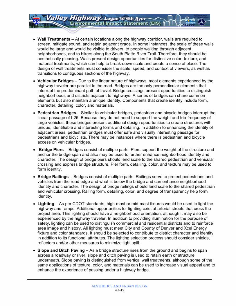
Figures 4.4-4, 4.4-5, 4.4-6, and 4.4-7 identify recommended locations for aesthetic mitigation for the Preferred Alternative and System Alternatives 1, 2, and 3, respectively. I-25 Improvements Most of the elements proposed for the I-25 and US 6 highway corridors (highway landscape, retaining walls, slope and ditch paving, and concrete barriers) are already present in the project area and therefore would not have an adverse impact or require mitigation. One exception is high-mast lighting, which is being used in other Denver area highways. Introduction of high-mast lighting would have a positive impact by providing more efficient coverage and therefore requiring fewer vertical elements, but it also has the potential to generate light pollution that would affect the upper-story occupants of residences near the highway. These fixtures should include reflectors to direct the light on the highway and away from residences, and their height should not infringe upon the view plane limits set by the City and County of Denver (see Washington Park View Plane on Figure 4.4-3). There are opportunities to enhance the design and to improve upon the appearance of some of the proposed typical highway elements. Highway landscapes throughout the project area, including the graded landscape slopes that retain sections of the highway and its ramps, topographical features and special plantings, should be more visually interesting and well-maintained. Plants should be chosen for low-maintenance and minimal water requirements as well as for visual interest. Slopes that are part of the linear highway corridor should be planted similarly so that the entire project area is consistent in vegetated appearance. Interchanges, or nodes - where the linear experience of the highway is interrupted - present opportunities for topographic or vegetative distinction to provide orientation and to reflect the identity and character of adjacent neighborhoods and districts (see the Aesthetics and Urban Design Report for example applications).

Legend
= Bridges
= Pedestrian and Bicycle Bridge
= Signage and Monumentation
= Bridge Piers and Railings
= Lighting
= Public Art and Special Features
= Highway Landscape - Graded Slope
= Highway Landscape - Feature
= Wall Treatment
= Slope and Ditch Paving
= Medians and Tree Lawns
= Pedestrian andBicycle Mobility
= Emphasis Area
= Wall Treatment
= Proposed Bike Route
= Proposed Slope andDitch Paving
= Landscape Improvements
= Existing Park
System Alternative 1Recommended Aesthetic Features
Figure 4.4-4
N o r t h
4.4-19

Legend
= Bridges
= Pedestrian and Bicycle Bridge
= Signage and Monumentation
= Bridge Piers and Railings
= Lighting
= Public Art and Special Features
= Highway Landscape - Graded Slope
= Highway Landscape - Feature
= Wall Treatment
= Slope and Ditch Paving
= Medians and Tree Lawns
= Pedestrian andBicycle Mobility
= Emphasis Area
= Wall Treatment
= Proposed Bike Route
= Proposed Slope andDitch Paving
= Landscape Improvements
= Existing Park
System Alternative 2Recommended Aesthetic Features
Figure 4.4-5
N o r t h
4.4-20

Legend
= Bridges
= Pedestrian and Bicycle Bridge
= Signage and Monumentation
= Bridge Piers and Railings
= Lighting
= Public Art and Special Features
= Highway Landscape - Graded Slope
= Highway Landscape - Feature
= Wall Treatment
= Slope and Ditch Paving
= Medians and Tree Lawns
= Pedestrian andBicycle Mobility
= Emphasis Area
= Wall Treatment
= Proposed Bike Route
= Proposed Slope andDitch Paving
= Landscape Improvements
= Existing Park
System Alternative 3Recommended Aesthetic Features
Figure 4.4-6
N o r t h
4.4-21
Preferred AlternativeRecommended Aesthetic Features
Figure 4.4-7
N o r t h
4.4-22

AESTHETICS AND URBAN DESIGN
4.4-23
Retaining walls, required to hold back adjacent grade, would be present throughout the project area. Walls present design opportunities for distinctive color, texture, patterns, and material treatments that would help to break down scale and to create a sense of place. Wall treatments within the linear corridor should be consistent and designed to enhance visual experience for the driver of a car traveling at high speeds. The design of wall treatments at interchanges should be distinctive in order to provide orientation and to reflect the identity and character of adjacent neighborhoods and districts. Where visible both from within the highway corridor and neighboring districts, wall treatments should operate both at the scale of the automobile and the pedestrian (see the Aesthetics and Urban Design Report for example applications). Slope and ditch paving is proposed to retain areas under arterial road bridges that pass over the highway and over the South Platte River corridor. Paving design should use a distinctive, yet simple, palette of materials, colors and textures that are visually stimulating to vehicular traffic traveling at highway speeds. Because it occurs at crossings that interrupt the linear experience of travel on the highway, slope and ditch paving should be different at each interchange to provide orientation and to reflect the identity and character of adjacent neighborhoods and districts (see Aesthetics and Urban Design Report for example applications). Because of the Broadway interchange area’s proximity to neighborhoods, transportation connections, and proposed mixed-use developments, the area has a growing pedestrian emphasis. Therefore, its open space plantings and topography should be distinctive from other sections of the highway to provide orientation and reflect the identity and character of this rapidly changing area. Public art and other special sculptural or landscape features should be considered (see Aesthetics and Urban Design Report for example applications). Improvements to the Broadway streetscape that are part of the separate I-25 Broadway viaduct replacement project will help to enhance the pedestrian and vehicular experience in an area dominated by transportation-related infrastructure. In the Santa Fe Drive interchange area, there are opportunities to enhance the design and improve upon the appearance of certain new elements that accompany the proposed changes. As mentioned in the consequences section (see Section 4.4.2), the joining of the north- and southbound I-25 lanes, and the moving of the loop ramp connecting Santa Fe Drive to northbound I-25, would create an additional open area in the vicinity of this interchange. These open areas and graded landscape slopes should be vegetated with plants chosen for low-maintenance, drainage enhancement, and visual interest. A water quality pond is proposed for the expanded open area between Kalamath Street and northbound I-25. This area could create a visual interest by using plants that exhibit distinctive seasonal color (see Aesthetics and Urban Design Report for example applications). Two bridges occur in the Santa Fe Drive interchange area—a ramp connecting northbound Santa Fe Drive to northbound I-25 and I-25 crossing over north- and southbound Santa Fe Drive. While their impact is not adverse due to the pre-existence of overhead structures in the area, there are opportunities to design distinctive structures, piers, and railings. If the new flyovers prove to be visible from the South Platte River Trail, additional trees could be planted along the river to increase the vegetated screen already provided by existing riparian vegetation. Slope and ditch paving that is proposed on either side of Santa Fe Drive, as it passes underneath I-25, should enhance visual interest for drivers by incorporating color and texture, or terracing to break down its scale.

AESTHETICS AND URBAN DESIGN
4.4-24
Walls that support the ramp connecting northbound Santa Fe Drive to northbound I-25, as well as those that retain the highway as it rises to a bridge over Santa Fe Drive, present design opportunities for distinctive color, texture, and material treatments that would enhance visual interest and help to break down scale (see the Aesthetics and Urban Design Report for example applications). In the Alameda Avenue interchange area, there are opportunities to enhance the design and improve upon the aesthetic qualities of the highway elements that accompany the proposed changes. Because of the Alameda Avenue interchange area’s proximity to neighborhoods, transportation connections, and recreation trail systems, this transitional area is developing a more pedestrian emphasis and distinct identity. Therefore, the design of all aesthetic applications to the interchange area should reflect neighborhood character, enhance safe and comfortable pedestrian and bicycle use, and provide orientation. The design of the structure, piers, rails, and lighting of the Alameda Avenue bridge over I-25, as well as the northbound I-25 on-ramp that departs from the west side of the Alameda Avenue bridge and crosses over the highway, should be strongly identifiable and achieve visual interest through distinctive forms, colors, materials, and details. If the new flyovers prove to be visible from the South Platte River Trail, additional trees could be planted along the river to increase the vegetated screen already provided by existing riparian vegetation. Slope and ditch paving that is proposed on either side of I-25 as it passes underneath Alameda Avenue should enhance visual interest for drivers and provide orientation by incorporating color and texture, or terracing to break down its scale. Walls that retain graded slopes at either side of I-25 as it passes under Alameda Avenue, as well as walls that retain the highway access ramps associated with this interchange should be treated with colors, textures, materials, and patterns that enhance recognition of the surrounding context, and are distinct from other interchanges in the system. Special treatment of highway retaining walls directly across from the Denver Waste Water Management facility should be considered also. Graded landscape slopes, supporting ramps, and inaccessible open spaces encircled by the loop ramps, present an opportunity for landscape features that enhance visual interest through the use of vegetation with seasonal color or distinctive forms. Medians proposed at the Alameda Avenue bridge should enhance safety, visual appeal, and neighborhood character with distinctive hardscape and vegetation materials. Signage, monuments, or public art should be considered to accentuate neighborhood identity. Possible locations for these applications include the Alameda Avenue bridge and graded landscape slopes at the northeast and southwest quadrants of the interchange. US 6 Improvements Avoidance, minimization, and mitigation measures for the US 6 improvements would be the same as those interchange-specific measures identified for the I-25 mainline improvements. No adverse impacts result from the loop ramp changes at the I-25/US 6 interchange. However, there are opportunities to improve the visual experience of the highway driver passing through the area, as well as bikers passing by on the South Platte River Trail underneath. Graded landscape slopes, supporting ramps and inaccessible open spaces encircled by the loop ramps, present an opportunity for landscape features that enhance visual interest through the use of vegetation with seasonal color or distinctive forms.

AESTHETICS AND URBAN DESIGN
4.4-25
Special features such as public art, sculpture, and monuments could provide visual interest and orientation by signaling arrival or departure at this transitional location between the regional US 6 highway and local 6th Avenue, which is a gateway to Denver. All improvements to this area should consider the safety and visual experience of bicyclists and pedestrians on the bike trail, which passes underneath along the South Platte River through Milstein Grove south of US 6 and Frog Hollow Park north of US 6. The visual experience of the highway by bicyclists and pedestrians could be improved with color, textural, and material changes to the undersides of the bridge structures that pass over the area. No adverse impacts have been identified at the US 6/Federal Boulevard interchange. However, there are opportunities to enhance the design and improve upon the aesthetic qualities of elements that accompany the proposed changes. Because of the proximity of the Federal Boulevard interchange to neighborhoods and recreational facilities, as well as other planned future improvements for the area (such as increased sidewalks), this area would develop a more pedestrian emphasis and distinct identity. Therefore, the design of all aesthetic applications to the interchange area should reflect neighborhood character, enhance safe and comfortable pedestrian and bicycle use, and provide orientation. The design of the structure, piers, rails, and lighting of the Federal Boulevard bridge over US 6 should be strongly identifiable and achieve visual interest through distinctive forms, colors, materials, and details. Slope and ditch paving that is proposed on either side of US 6 as it passes underneath Federal should enhance visual interest for drivers, provide orientation, incorporate color and texture, or include terracing to break down its scale. Walls that retain graded slopes at either side of US 6 as it passes under Federal Boulevard should be treated with colors, textures, materials, and patterns that enhance recognition of the surrounding context and make them distinct from other interchanges in the system. Medians proposed at the Federal Boulevard bridge should enhance safety, visual appeal, and neighborhood character with distinctive hardscape and vegetation materials. Signage, monuments, or public art should be considered to accentuate neighborhood identity. Possible locations for these applications include the Federal Boulevard bridge (see the Aesthetics and Urban Design Report for example applications). Santa Fe Drive / Kalamath Street Improvements The greatest impact resulting from the proposed Santa Fe Drive/Kalamath Street improvements at Alameda Avenue is grade-separating Santa Fe Drive and Kalamath Street beneath the railroad tracks. The adverse experience of driving below-grade in a dark canyon-like passage between retaining walls can be mitigated with wall treatments. Design of these treatments should provide a lightening effect, enhance visual interest, and break down the scale of large wall expanses by incorporating a mix of materials, colors, patterns, and textures. They should operate at the scale of the automobile and the pedestrian, and their themes or materials should enhance recognition of surrounding contexts (see the Aesthetics and Urban Design Report for example applications). The proposed pedestrian and bicycle bridge over the highway at Bayaud Avenue to connect the South Platte River Trail on the west side of the river to the Baker neighborhood on its east side presents an opportunity for creating a special feature that provides orientation and neighborhood distinction. The structure and its elements should incorporate unique forms, materials, and colors and incorporate public art and other forms of monuments (see the Aesthetics and Urban Design Report for example application).

AESTHETICS AND URBAN DESIGN
4.4-26
4.4.4 Mitigation Measures As described above, the replacement of aging transportation structures with new, more visually appealing structures will have a positive aesthetic effect in many areas. During final design, CDOT will identify appropriate aesthetic design elements and enhancements to ensure compatibility with the surrounding areas and provide a positive visual experience. Future design goals/considerations identified above will provide a guide during final design. Mitigation measures to soften and enhance the aesthetics character of the project will be detailed in final design and will include the following:
• Provide architectural interest and/or color into retaining wall, bridge, and lighting design.
• Reduce impacts of the overpasses and overhead bridges through careful architectural detailing of the railings and other features. Colors and textures would be compatible with those existing in the corridor.
• Where existing landscaped right-of-way areas are impacted by the project, re-landscape to provide continuity such that the existing landscaped areas do not become fragmented.
• Incorporate landscaping within the right-of-way wherever space is available, including interchange infields and gore areas, in order to screen adjacent neighborhoods and land uses from the highway corridor, as well as to visually enhance the over all corridor.
• Continue coordination with local agencies, communities, and business groups to identify features such as landscaping, slope and ditch paving, signage and monumentation and public art that can be implemented, either by CDOT or in cooperation with others, to add interest and appeal to transportation nodes.


![Mainline 1 [1]](https://img.pdfslide.us/doc/110x75/577d35831a28ab3a6b90a590/mainline-1-1.jpg)