Embed Size (px)
Citation preview
MapXtreme 2005 WMS
WMS MapXtreme2005 WMS WMS
WMS Open GeospatialConsortium (OGC) (http://www.opengeospatial.org/docs/01-068r3.pdf)
...
. . . . . . . . . . . . . . . . . . . . . . . . . . . . . . . . . . . . . . . . . . . . . . 2. . . . . . . . . . . . . . . . . . . . . . . . . . . . . . . . . . . . . . . . . . . 2
IIS WMS . . . . . . . . . . . . . . . . . . . . . . . . . . . . . . . 2 WMS . . . . . . . . . . . . . . . . . . . . . . . . . . . . . . . . . . . . 12
. . . . . . . . . . . . . . . . . . . . . . . . . . . . . . . . . 16WMS . . . . . . . . . . . . . . . . . . . . . . . . . . . . . . . . 20
. . . . . . . . . . . . . . . . . . . . . . . . . . . . . . . . . . . . 22
MapXtreme 2005 WMS
Web (WMS) Mapinfo WMS WMS 1.1.1 OGC WMS HTTP GIS
GIF JPG PNG -
WMS MapXtreme
OGC WMS (http://www.opengeospatial.org/docs/01-068r3.pdf)
MapXtreme 2005 Web
• MapXtreme 2005
• Internet (IIS)• ASP.NET v1.1.4322
Windows C:\Windows
MapXtreme 2005 ASP.NET
IIS WMS
MapXtreme 2005 WMS
WMS .
Web
1. MapInfo.WMS.Server 2.3. MapXtreme 2005 4.5. Web 6. IIS 7.8.
MapXtreme 2005 v6.5
© 2006 MapInfo Corporation. 2 MapXtreme2005_WMS_Server_Setup_Tutorial.pdf
MapXtreme 2005 WMS
1 Web.config MapInfo
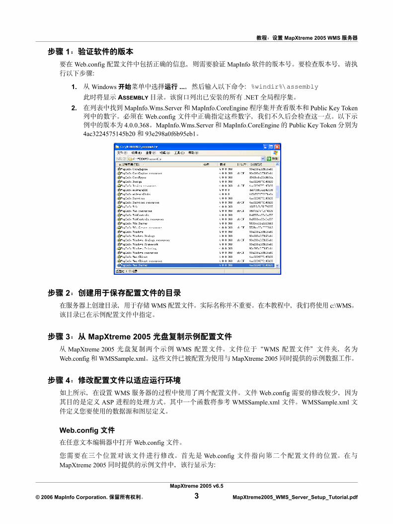
1. Windows ... %windir%\assembly
ASSEMBLY .NET 2. MapInfo.Wms.Server MapInfo.CoreEngine Public Key Token
Web.config 4.0.0.368 MapInfo.Wms.Server MapInfo.CoreEngine Public Key Token
4ac3224575145b20 93e298a0f6b95eb1
2 WMS c:\WMS
3 MapXtreme 2005 MapXtreme 2005 WMS WMS
Web.config WMSSample.xml MapXtreme 2005
4 WMS Web.config
ASP WMSSample.xml WMSSample.xml
Web.config Web.config
Web.config MapXtreme 2005
MapXtreme 2005 v6.5
© 2006 MapInfo Corporation. 3 MapXtreme2005_WMS_Server_Setup_Tutorial.pdf
MapXtreme 2005 WMS
<configuration><appSettings>
<add key="configFile" value="C:\wms\WMSSample.xml" />
MapInfo.Wms.Server MapInfo.CoreEngine Public Key Tokens 1
<system.web><httpHandlers>
<add verb="GET,POST" path="*.ashx" type="MapInfo.Wms.WmsHttpHandler,MapInfo.Wms.Server, Version=4.0.0.352, Culture=neutral,PublicKeyToken=4ac3224575145b20"/>
</httpHandlers><httpModules>
<add type="MapInfo.Engine.WebSessionActivator, MapInfo.CoreEngine, Version=4.0.0.352, Culture=neutral, PublicKeyToken=93e298a0f6b95eb1" name="WebSessionActivator" />
</httpModules>
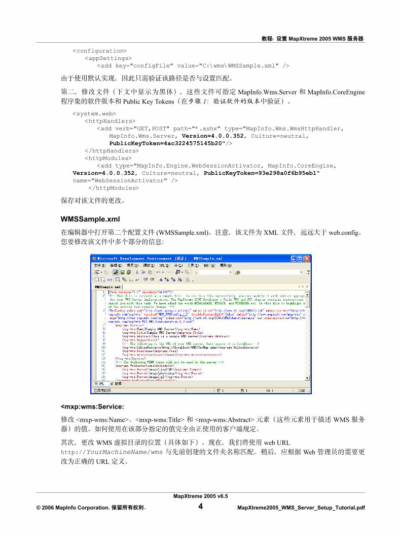
WMSSample.xml
(WMSSample.xml) XML web.config
<mxp:wms:Service:
<mxp-wms:Name> <mxp-wms:Title> <mxp-wms:Abstract> WMS
WMS web URL http://YourMachineName/wms Web
URL
MapXtreme 2005 v6.5
© 2006 MapInfo Corporation. 4 MapXtreme2005_WMS_Server_Setup_Tutorial.pdf
MapXtreme 2005 WMS
MITestServer MITestServer
<?xml version="1.0" encoding="utf-8"?><!-- This file is intended as a sample file. To use this file successfully, you must modify it with entries appropriate for your WMS Server implementation. The MapXtreme 2005 Developer's Guide WMS and WFS chapter contains instructions to assist you with this task. We have added the words MYDATABASE, MYPATH, and MYSERVER etc. in this file to highlight some of the entries that require change. --> <mxp-wms:WmsConfig xmlns:gml="http://www.opengis.net/gml" xmlns:xlink="http://www.w3.org/1999/xlink" xmlns:mxp-wms="http://www.mapinfo.com/mxp/wms" version="MXP_WMSConfig_1_0" disableFeatureInfo="false" xmlns="http://www.mapinfo.com/mxp/wms" xmlns:mxp="http://www.mapinfo.com/mxp" xmlns:xsi="http://www.w3.org/2001/XMLSchema-instance" xsi:schemaLocation="http://www.mapinfo.com/mxp/wms MXP_WMS_Configuration_1_0.xsd">
<mxp-wms:Service><mxp-wms:Name>Sample WMS Server</mxp-wms:Name><mxp-wms:Title>Sample WMS Server</mxp-wms:Title><mxp-wms:Abstract>This is a sample WMS server</mxp-wms:Abstract><mxp-wms:KeywordList/><!-- The following is the URL of the WMS server --><mxp-wms:OnlineResource>http://MITestServer/WMS/GetMap.ashx
</mxp-wms:OnlineResource><mxp-wms:Fees>none</mxp-wms:Fees><mxp-wms:AccessConstraints>none</mxp-wms:AccessConstraints>
</mxp-wms:Service><!-- The following MIME types will not be used by the server --><mxp-wms:WmsRasterFormatExcludeSet>
<mxp-wms:Format>image/jpeg2000</mxp-wms:Format><mxp-wms:Format>image/photoshop</mxp-wms:Format><mxp-wms:Format>image/jp2</mxp-wms:Format>
</mxp-wms:WmsRasterFormatExcludeSet>
<DataSourceDefinitionSet>
WMSSample.xml <DataSourceDefinitionSet>
<WMSLayer> WMSSample.xml MapXtreme 2005
<DataSourceDefinitionSet xmlns="http://www.mapinfo.com/mxp/wms"><!-- The following data sources reference local TAB files, you need to replace
MYPATH with the real path to those tab files. --><TABFileDataSourceDefinition id="id1" readOnly="false" xmlns="http://
www.mapinfo.com/mxp"><DataSourceName>STATES</DataSourceName><FileName>MYPATH\USA.TAB</FileName>
</TABFileDataSourceDefinition><TABFileDataSourceDefinition id="id2" readOnly="false" xmlns="http://
www.mapinfo.com/mxp"><DataSourceName>US_HIWAY</DataSourceName><FileName>MYPATH\US_HIWAY.TAB</FileName>
</TABFileDataSourceDefinition><TABFileDataSourceDefinition id="id5" readOnly="false" xmlns="http://
www.mapinfo.com/mxp"><DataSourceName>OCEAN</DataSourceName><FileName>MYPATH\OCEAN.TAB</FileName>
</TABFileDataSourceDefinition>
MapXtreme 2005 v6.5
© 2006 MapInfo Corporation. 5 MapXtreme2005_WMS_Server_Setup_Tutorial.pdf
MapXtreme 2005 WMS
<TABFileDataSourceDefinition> id <DataSourceName> Id id id1 id2 id5 States
US_Highways Ocean
<TABFileDataSourceDefinition> <FileName>
c:\Program Files\MapInfo\MapXtreme\<version number>\Samples\Data
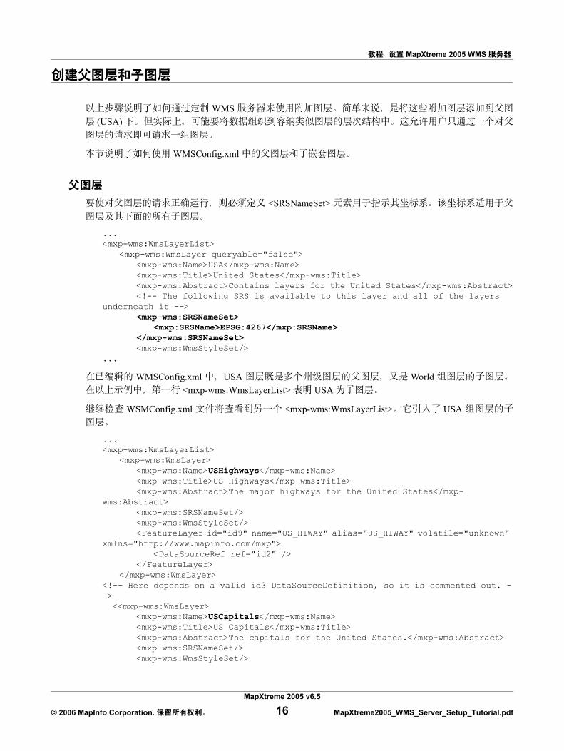
<wms:WmsLayerList>
WMS 13
WMSConfig.xml
<mxp-wms:WmsLayer><mxp-wms:Name>States</mxp-wms:Name><mxp-wms:Title>States</mxp-wms:Title><mxp-wms:SRSNameSet/><mxp-wms:WmsStyleSet>
...style information removed for clarity</mxp-wms:WmsStyleSet><FeatureLayer id="id8" name="STATES" alias="STATES" volatile="unknown"
xmlns="http://www.mapinfo.com/mxp"><DataSourceRef ref="States"/>
</FeatureLayer></mxp-wms:WmsLayer><mxp-wms:WmsLayer>
<mxp-wms:Name>USHighways</mxp-wms:Name><mxp-wms:Title>US Highways</mxp-wms:Title><mxp-wms:Abstract>The major highways for the United States</mxp-
wms:Abstract><mxp-wms:SRSNameSet/><mxp-wms:WmsStyleSet/><FeatureLayer id="id9" name="US_HIWAY" alias="US_HIWAY" volatile="unknown"
xmlns="http://www.mapinfo.com/mxp"><DataSourceRef ref="US_Highway"/>
</FeatureLayer></mxp-wms:WmsLayer>
<mxp-wms:WmsLayer><mxp-wms:Name>Oceans</mxp-wms:Name><mxp-wms:Title>Oceans</mxp-wms:Title><mxp-wms:Abstract>The oceans of the world</mxp-wms:Abstract><mxp-wms:SRSNameSet/><mxp-wms:WmsStyleSet/><mxp:FeatureLayer id="id12" name="OCEAN" alias="OCEAN" volatile="unknown">
<mxp:DataSourceRef ref="Ocean"/></mxp:FeatureLayer>
</mxp-wms:WmsLayer>
<DataSourceRef> <DataSourceDefinitionSet> <TABFileDataSourceDefinition> id
MapXtreme 2005 v6.5
© 2006 MapInfo Corporation. 6 MapXtreme2005_WMS_Server_Setup_Tutorial.pdf
MapXtreme 2005 WMS
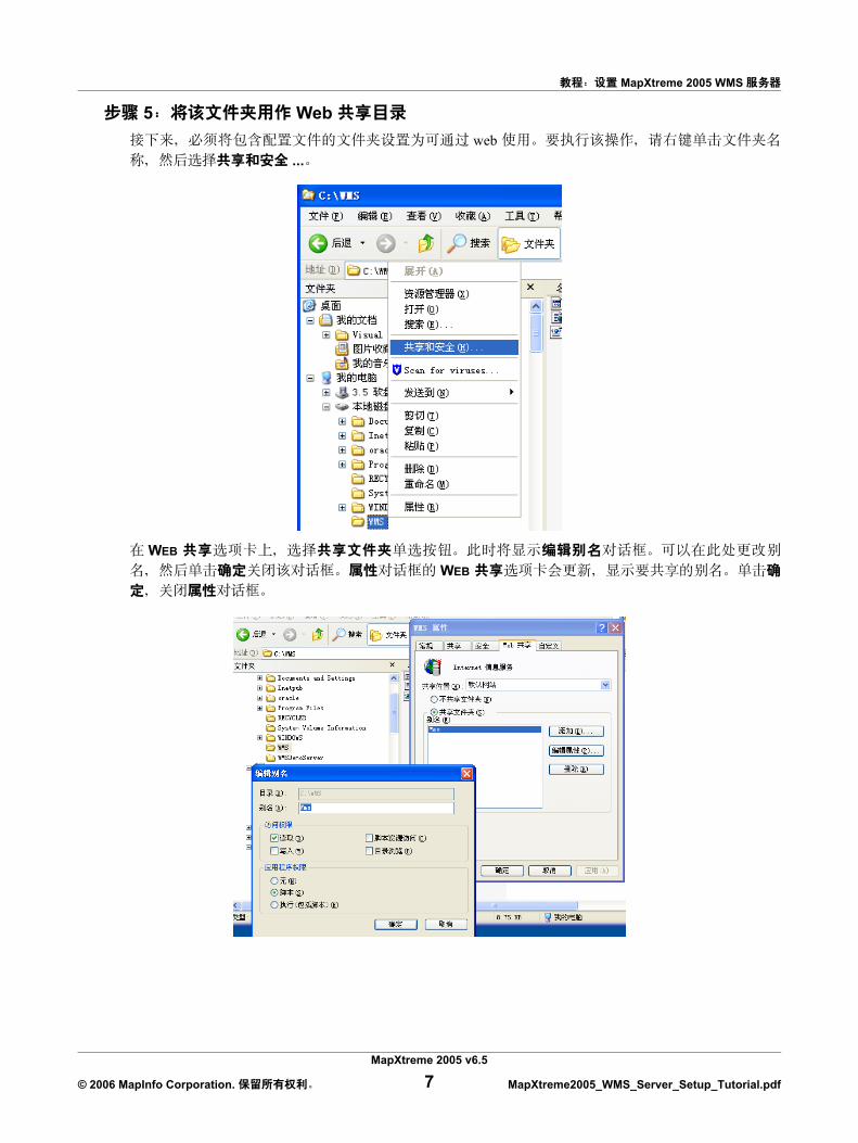
5 Web web
...
WEB WEB
MapXtreme 2005 v6.5
© 2006 MapInfo Corporation. 7 MapXtreme2005_WMS_Server_Setup_Tutorial.pdf
MapXtreme 2005 WMS
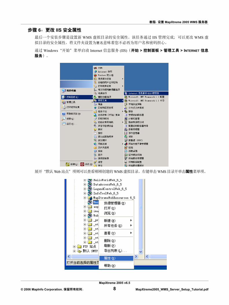
6 IIS WMS IIS WMS
Windows Internet (IIS) > > > INTERNET
Web WMS WMS
MapXtreme 2005 v6.5
© 2006 MapInfo Corporation. 8 MapXtreme2005_WMS_Server_Setup_Tutorial.pdf
MapXtreme 2005 WMS
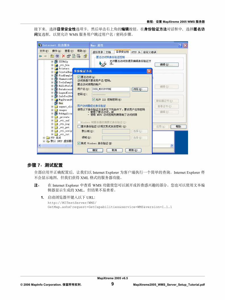
WMS /
7 Internet Explorer Internet Explorer
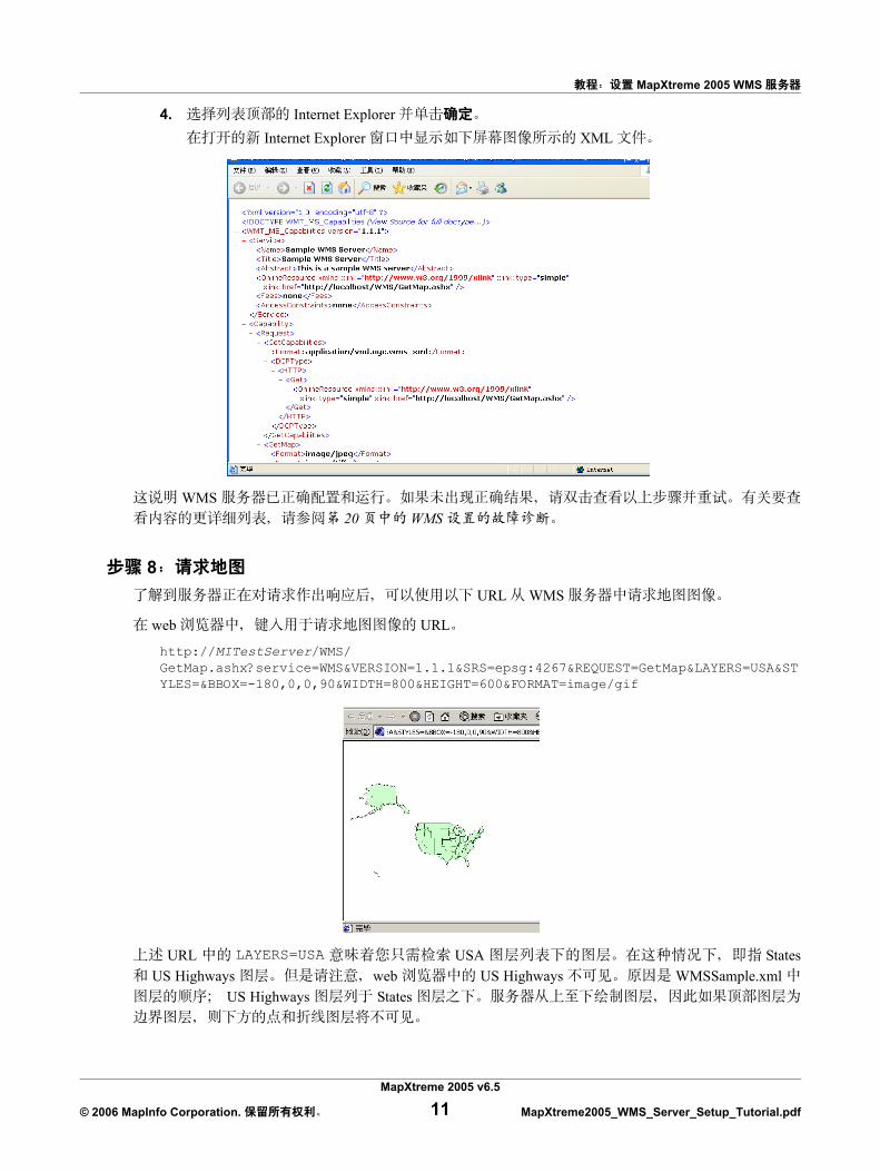
XML
Internet Explorer WMS XML
1. URLhttp://MITestServer/WMS/GetMap.ashx?request=GetCapabilities&service=WMS&version=1.1.1
MapXtreme 2005 v6.5
© 2006 MapInfo Corporation. 9 MapXtreme2005_WMS_Server_Setup_Tutorial.pdf
MapXtreme 2005 WMS
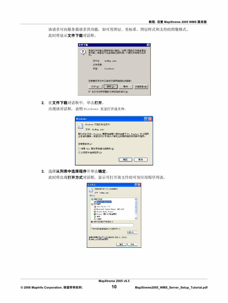
2. Windows
3.
MapXtreme 2005 v6.5
© 2006 MapInfo Corporation. 10 MapXtreme2005_WMS_Server_Setup_Tutorial.pdf
MapXtreme 2005 WMS
4. Internet Explorer Internet Explorer XML
WMS 20 WMS
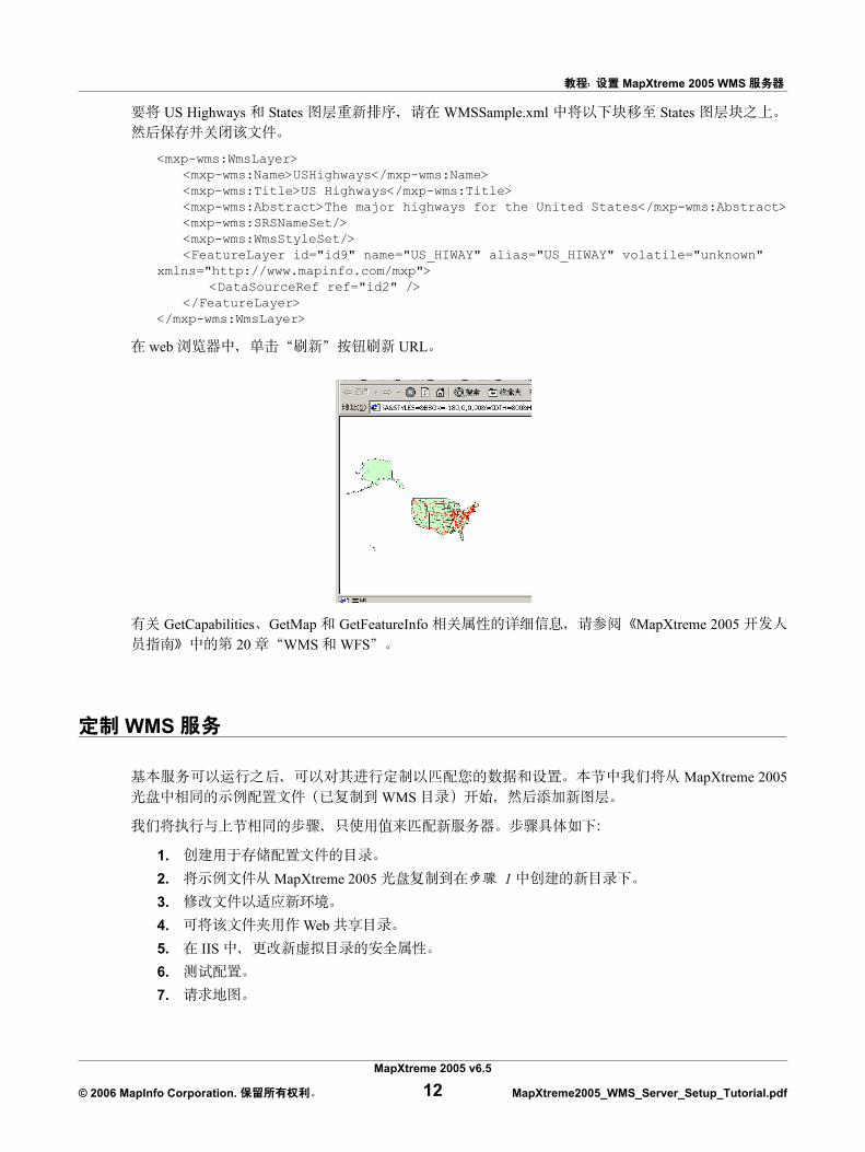
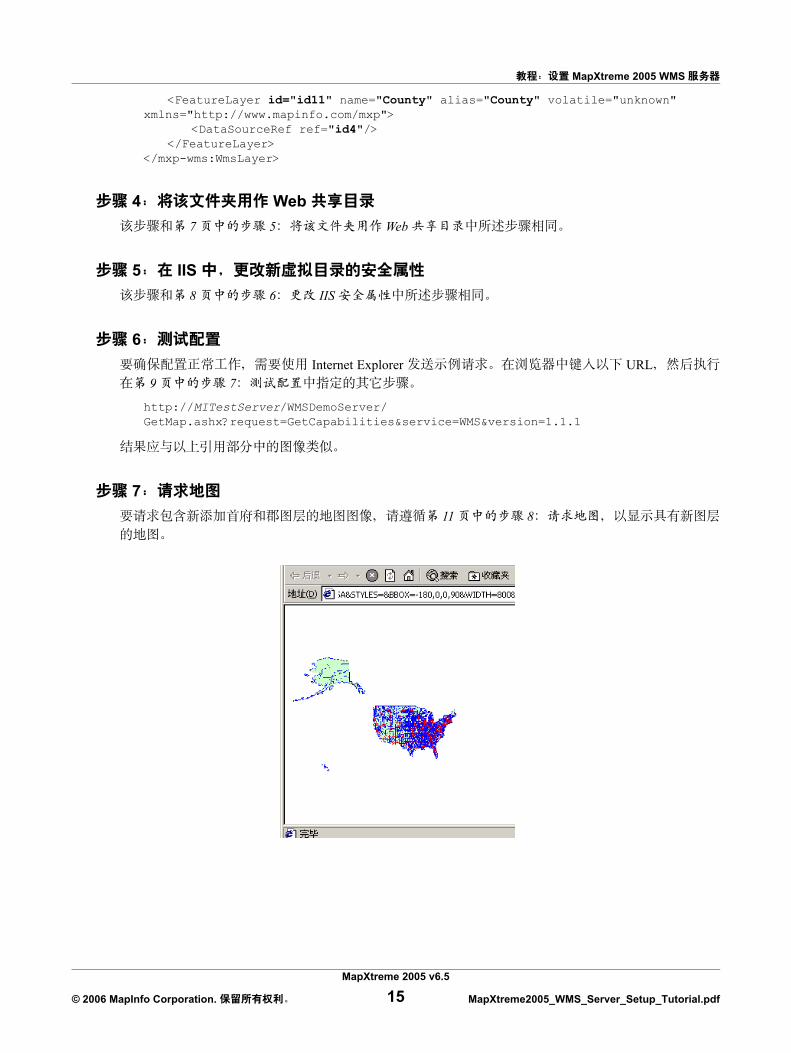
8 URL WMS
web URL
http://MITestServer/WMS/GetMap.ashx?service=WMS&VERSION=1.1.1&SRS=epsg:4267&REQUEST=GetMap&LAYERS=USA&STYLES=&BBOX=-180,0,0,90&WIDTH=800&HEIGHT=600&FORMAT=image/gif
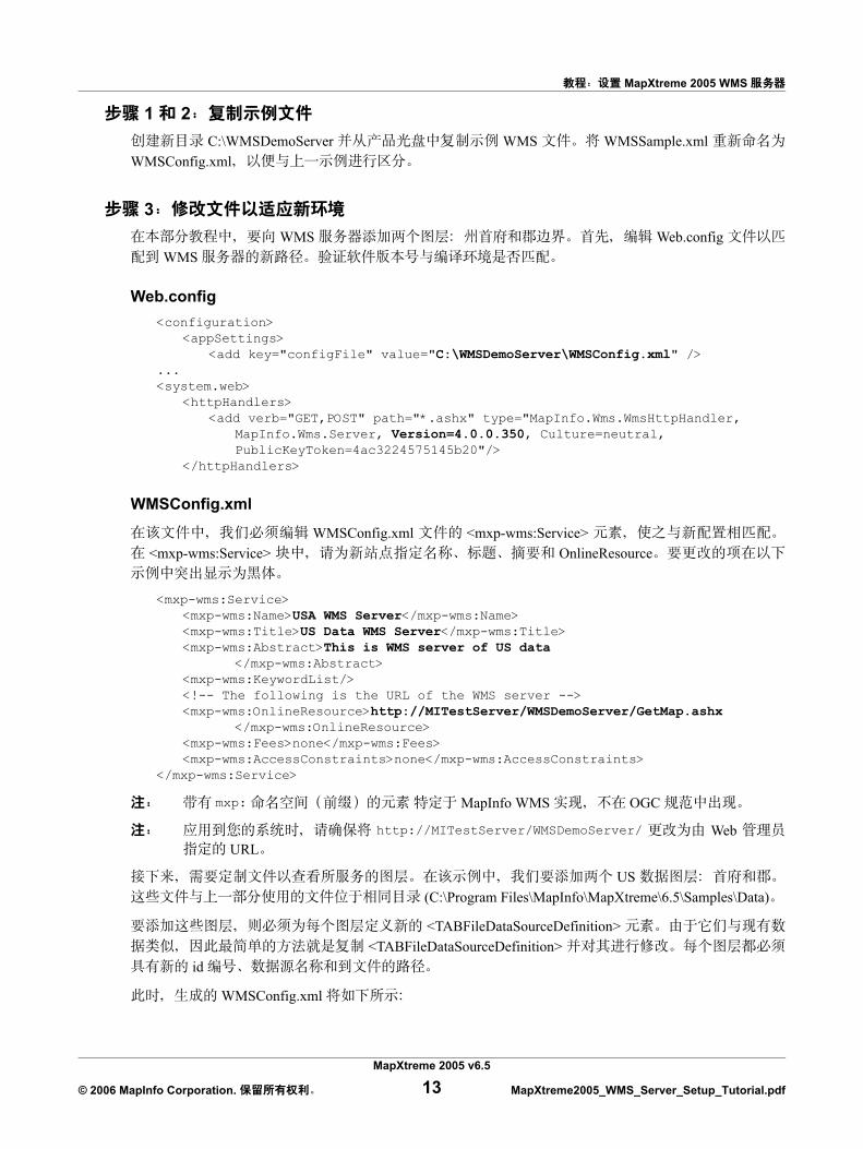
URL LAYERS=USA USA States US Highways web US Highways WMSSample.xml
US Highways States
MapXtreme 2005 v6.5
© 2006 MapInfo Corporation. 11 MapXtreme2005_WMS_Server_Setup_Tutorial.pdf
MapXtreme 2005 WMS
US Highways States WMSSample.xml States
<mxp-wms:WmsLayer><mxp-wms:Name>USHighways</mxp-wms:Name><mxp-wms:Title>US Highways</mxp-wms:Title><mxp-wms:Abstract>The major highways for the United States</mxp-wms:Abstract><mxp-wms:SRSNameSet/><mxp-wms:WmsStyleSet/><FeatureLayer id="id9" name="US_HIWAY" alias="US_HIWAY" volatile="unknown"
xmlns="http://www.mapinfo.com/mxp"><DataSourceRef ref="id2" />
</FeatureLayer></mxp-wms:WmsLayer>
web URL
GetCapabilities GetMap GetFeatureInfo MapXtreme 2005 20 WMS WFS
WMS
MapXtreme 2005 WMS
1.2. MapXtreme 2005 13.4. Web 5. IIS 6.7.
MapXtreme 2005 v6.5
© 2006 MapInfo Corporation. 12 MapXtreme2005_WMS_Server_Setup_Tutorial.pdf
MapXtreme 2005 WMS
1 2 C:\WMSDemoServer WMS WMSSample.xml
WMSConfig.xml
3 WMS Web.config
WMS
Web.config<configuration>
<appSettings><add key="configFile" value="C:\WMSDemoServer\WMSConfig.xml" />
...<system.web>
<httpHandlers><add verb="GET,POST" path="*.ashx" type="MapInfo.Wms.WmsHttpHandler,
MapInfo.Wms.Server, Version=4.0.0.350, Culture=neutral,PublicKeyToken=4ac3224575145b20"/>
</httpHandlers>
WMSConfig.xml
WMSConfig.xml <mxp-wms:Service> <mxp-wms:Service> OnlineResource
<mxp-wms:Service><mxp-wms:Name>USA WMS Server</mxp-wms:Name><mxp-wms:Title>US Data WMS Server</mxp-wms:Title><mxp-wms:Abstract>This is WMS server of US data
</mxp-wms:Abstract><mxp-wms:KeywordList/><!-- The following is the URL of the WMS server --><mxp-wms:OnlineResource>http://MITestServer/WMSDemoServer/GetMap.ashx
</mxp-wms:OnlineResource><mxp-wms:Fees>none</mxp-wms:Fees><mxp-wms:AccessConstraints>none</mxp-wms:AccessConstraints>
</mxp-wms:Service>
mxp: MapInfo WMS OGC
http://MITestServer/WMSDemoServer/ Web URL
US (C:\Program Files\MapInfo\MapXtreme\6.5\Samples\Data)
<TABFileDataSourceDefinition> <TABFileDataSourceDefinition>
id
WMSConfig.xml
MapXtreme 2005 v6.5
© 2006 MapInfo Corporation. 13 MapXtreme2005_WMS_Server_Setup_Tutorial.pdf
MapXtreme 2005 WMS
<TABFileDataSourceDefinition id="id1" readOnly="false" xmlns="http://www.mapinfo.com/mxp">
<DataSourceName>STATES</DataSourceName><FileName>C:\Program Files\MapInfo\MapXtreme\6.5\Samples\Data\USA.TAB</
FileName></TABFileDataSourceDefinition><TABFileDataSourceDefinition id="id2" readOnly="false" xmlns="http://www.mapinfo.com/mxp">
<DataSourceName>US_HIWAY</DataSourceName><FileName>C:\Program Files\MapInfo\MapXtreme\6.5\Samples\Data\US_HIWAY.TAB</
FileName></TABFileDataSourceDefinition><TABFileDataSourceDefinition id="id3" readOnly="false" xmlns="http://www.mapinfo.com/mxp">
<DataSourceName>US Capitals</DataSourceName><FileName>C:\Program Files\MapInfo\MapXtreme\6.5\Samples\Data\usa_caps.TAB</
FileName></TABFileDataSourceDefinition><TABFileDataSourceDefinition id="id4" readOnly="false" xmlns="http://www.mapinfo.com/mxp">
<DataSourceName>US County Boundaries</DataSourceName><FileName>C:\Program Files\MapInfo\MapXtreme\6.5\Samples\Data\us_cnty.TAB</
FileName></TABFileDataSourceDefinition><TABFileDataSourceDefinition id="id5" readOnly="false" xmlns="http://www.mapinfo.com/mxp">
<DataSourceName>OCEAN</DataSourceName><FileName>C:\Program Files\MapInfo\MapXtreme\6.5\Samples\Data\OCEAN.TAB</
FileName></TABFileDataSourceDefinition>
XML <WMSLayer> WMSLayer US Capitals (<!--) ( -- >) WMSConfig.xml
<!-- Here depends on a valid id3 DataSourceDefinition, so it is commented out. --><!--<<mxp-wms:WmsLayer><mxp-wms:Name>USCapitals</mxp-wms:Name><mxp-wms:Title>US Capitals</mxp-wms:Title><mxp-wms:Abstract>The capitals for the United States.</mxp-wms:Abstract><mxp-wms:SRSNameSet/><mxp-wms:WmsStyleSet/><FeatureLayer id="id10" name="STATECAP" alias="STATECAP" volatile="unknown"
xmlns="http://www.mapinfo.com/mxp"><DataSourceRef ref="id3" />
</FeatureLayer></mxp-wms:WmsLayer>-->
US Capitals States DataSourceRef id
<<mxp-wms:WmsLayer><mxp-wms:Name>US Counties</mxp-wms:Name><mxp-wms:Title>US County Boundaries</mxp-wms:Title><mxp-wms:Abstract>County boundaries for the United States.</mxp-wms:Abstract><mxp-wms:SRSNameSet/><mxp-wms:WmsStyleSet/>
MapXtreme 2005 v6.5
© 2006 MapInfo Corporation. 14 MapXtreme2005_WMS_Server_Setup_Tutorial.pdf
MapXtreme 2005 WMS
<FeatureLayer id="id11" name="County" alias="County" volatile="unknown" xmlns="http://www.mapinfo.com/mxp">
<DataSourceRef ref="id4"/></FeatureLayer>
</mxp-wms:WmsLayer>
4 Web 7 5 Web
5 IIS 8 6 IIS
6 Internet Explorer URL
9 7
http://MITestServer/WMSDemoServer/GetMap.ashx?request=GetCapabilities&service=WMS&version=1.1.1
7 11 8
MapXtreme 2005 v6.5
© 2006 MapInfo Corporation. 15 MapXtreme2005_WMS_Server_Setup_Tutorial.pdf
MapXtreme 2005 WMS
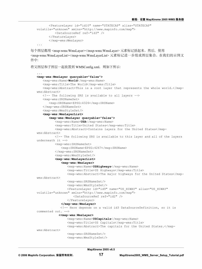
WMS (USA)
WMSConfig.xml
<SRSNameSet>
...<mxp-wms:WmsLayerList>
<mxp-wms:WmsLayer queryable="false"><mxp-wms:Name>USA</mxp-wms:Name><mxp-wms:Title>United States</mxp-wms:Title><mxp-wms:Abstract>Contains layers for the United States</mxp-wms:Abstract><!-- The following SRS is available to this layer and all of the layers
underneath it --><mxp-wms:SRSNameSet>
<mxp:SRSName>EPSG:4267</mxp:SRSName></mxp-wms:SRSNameSet><mxp-wms:WmsStyleSet/>
...
WMSConfig.xml USA World <mxp-wms:WmsLayerList> USA
WSMConfig.xml <mxp-wms:WmsLayerList> USA
...<mxp-wms:WmsLayerList>
<mxp-wms:WmsLayer><mxp-wms:Name>USHighways</mxp-wms:Name><mxp-wms:Title>US Highways</mxp-wms:Title><mxp-wms:Abstract>The major highways for the United States</mxp-
wms:Abstract><mxp-wms:SRSNameSet/><mxp-wms:WmsStyleSet/><FeatureLayer id="id9" name="US_HIWAY" alias="US_HIWAY" volatile="unknown"
xmlns="http://www.mapinfo.com/mxp"><DataSourceRef ref="id2" />
</FeatureLayer></mxp-wms:WmsLayer>
<!-- Here depends on a valid id3 DataSourceDefinition, so it is commented out. --> <<mxp-wms:WmsLayer>
<mxp-wms:Name>USCapitals</mxp-wms:Name><mxp-wms:Title>US Capitals</mxp-wms:Title><mxp-wms:Abstract>The capitals for the United States.</mxp-wms:Abstract><mxp-wms:SRSNameSet/><mxp-wms:WmsStyleSet/>
MapXtreme 2005 v6.5
© 2006 MapInfo Corporation. 16 MapXtreme2005_WMS_Server_Setup_Tutorial.pdf
MapXtreme 2005 WMS
<FeatureLayer id="id10" name="STATECAP" alias="STATECAP" volatile="unknown" xmlns="http://www.mapinfo.com/mxp">
<DataSourceRef ref="id3" /></FeatureLayer></mxp-wms:WmsLayer>
...
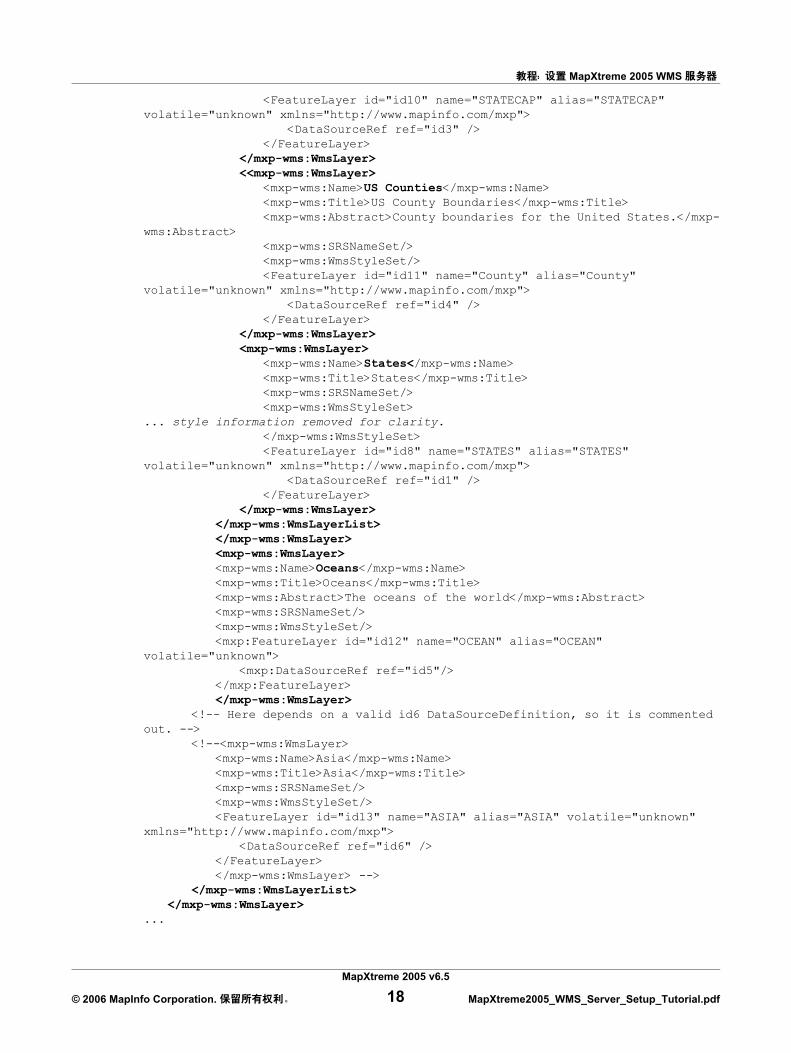
<mxp-wms:WmsLayer></mxp-wms:WmsLayer> <mxp-wms:WmsLayerList></mxp-wms:WmsLayerList>
WMSConfig.xml
...<mxp-wms:WmsLayer queryable="false">
<mxp-wms:Name>World</mxp-wms:Name><mxp-wms:Title>The World</mxp-wms:Title><mxp-wms:Abstract>This is a root layer that represents the whole world.</mxp-
wms:Abstract><!-- The following SRS is available to all layers --><mxp-wms:SRSNameSet>
<mxp:SRSName>EPSG:4326</mxp:SRSName></mxp-wms:SRSNameSet><mxp-wms:WmsStyleSet/><mxp-wms:WmsLayerList>
<mxp-wms:WmsLayer queryable="false"><mxp-wms:Name>USA</mxp-wms:Name><mxp-wms:Title>United States</mxp-wms:Title><mxp-wms:Abstract>Contains layers for the United States</mxp-
wms:Abstract><!-- The following SRS is available to this layer and all of the layers
underneath it --><mxp-wms:SRSNameSet>
<mxp:SRSName>EPSG:4267</mxp:SRSName></mxp-wms:SRSNameSet><mxp-wms:WmsStyleSet/><mxp-wms:WmsLayerList>
<mxp-wms:WmsLayer><mxp-wms:Name>USHighways</mxp-wms:Name><mxp-wms:Title>US Highways</mxp-wms:Title><mxp-wms:Abstract>The major highways for the United States</mxp-
wms:Abstract><mxp-wms:SRSNameSet/><mxp-wms:WmsStyleSet/><FeatureLayer id="id9" name="US_HIWAY" alias="US_HIWAY"
volatile="unknown" xmlns="http://www.mapinfo.com/mxp"><DataSourceRef ref="id2" />
</FeatureLayer></mxp-wms:WmsLayer>
<!-- Here depends on a valid id3 DataSourceDefinition, so it is commented out. -->
<<mxp-wms:WmsLayer><mxp-wms:Name>USCapitals</mxp-wms:Name><mxp-wms:Title>US Capitals</mxp-wms:Title><mxp-wms:Abstract>The capitals for the United States.</mxp-
wms:Abstract><mxp-wms:SRSNameSet/><mxp-wms:WmsStyleSet/>
MapXtreme 2005 v6.5
© 2006 MapInfo Corporation. 17 MapXtreme2005_WMS_Server_Setup_Tutorial.pdf
MapXtreme 2005 WMS
<FeatureLayer id="id10" name="STATECAP" alias="STATECAP" volatile="unknown" xmlns="http://www.mapinfo.com/mxp">
<DataSourceRef ref="id3" /></FeatureLayer>
</mxp-wms:WmsLayer><<mxp-wms:WmsLayer>
<mxp-wms:Name>US Counties</mxp-wms:Name><mxp-wms:Title>US County Boundaries</mxp-wms:Title><mxp-wms:Abstract>County boundaries for the United States.</mxp-
wms:Abstract><mxp-wms:SRSNameSet/><mxp-wms:WmsStyleSet/><FeatureLayer id="id11" name="County" alias="County"
volatile="unknown" xmlns="http://www.mapinfo.com/mxp"><DataSourceRef ref="id4" />
</FeatureLayer></mxp-wms:WmsLayer><mxp-wms:WmsLayer>
<mxp-wms:Name>States</mxp-wms:Name><mxp-wms:Title>States</mxp-wms:Title><mxp-wms:SRSNameSet/><mxp-wms:WmsStyleSet>
... style information removed for clarity.</mxp-wms:WmsStyleSet><FeatureLayer id="id8" name="STATES" alias="STATES"
volatile="unknown" xmlns="http://www.mapinfo.com/mxp"><DataSourceRef ref="id1" />
</FeatureLayer></mxp-wms:WmsLayer>
</mxp-wms:WmsLayerList></mxp-wms:WmsLayer><mxp-wms:WmsLayer><mxp-wms:Name>Oceans</mxp-wms:Name><mxp-wms:Title>Oceans</mxp-wms:Title><mxp-wms:Abstract>The oceans of the world</mxp-wms:Abstract><mxp-wms:SRSNameSet/><mxp-wms:WmsStyleSet/><mxp:FeatureLayer id="id12" name="OCEAN" alias="OCEAN"
volatile="unknown"><mxp:DataSourceRef ref="id5"/>
</mxp:FeatureLayer></mxp-wms:WmsLayer>
<!-- Here depends on a valid id6 DataSourceDefinition, so it is commented out. -->
<!--<mxp-wms:WmsLayer><mxp-wms:Name>Asia</mxp-wms:Name><mxp-wms:Title>Asia</mxp-wms:Title><mxp-wms:SRSNameSet/><mxp-wms:WmsStyleSet/><FeatureLayer id="id13" name="ASIA" alias="ASIA" volatile="unknown"
xmlns="http://www.mapinfo.com/mxp"><DataSourceRef ref="id6" />
</FeatureLayer></mxp-wms:WmsLayer> -->
</mxp-wms:WmsLayerList></mxp-wms:WmsLayer>
...
MapXtreme 2005 v6.5
© 2006 MapInfo Corporation. 18 MapXtreme2005_WMS_Server_Setup_Tutorial.pdf
MapXtreme 2005 WMS
WMSConfig.xml
OGC WMS (http://www.opengeospatial.org/docs/01-068r3.pdf)
<Name> <Title> OGC WMS Name TitleName Title
<wms:WMSLayer>
mxp: MapInfo WMS OGC
<Name>
<Name>NYSStreets</Name>
<Title>
<Title>New York State Streets</Title>
<Abstract>
<Abstract>Streets and roads in New York State</Abstract>
<SRSNameSet> <mxp:SRSName>
<mxp:SRSName> <mxp:SRSName>
<mxp:SRSName>
<mxp:SRSName>epsg:4326</mxp:SRSName>
<WmsStyleSet> <WmsStyle>
<WmsStyle> <WmsStyle> <Name> <Title> <Abstract>
mxp: namespace
MapXtreme 2005 v6.5
© 2006 MapInfo Corporation. 19 MapXtreme2005_WMS_Server_Setup_Tutorial.pdf
MapXtreme 2005 WMS
<WmsStyleSet><WmsStyle>
<Name>StreetStyle</Name><Title>Street Style</Title><Abstract>This is the line style for displaying streets.</Abstract><mxp:LineStyle stroke="black" width="1"
width-unit="mapinfo:imagesize pixel"><Pen>mapinfo:pen 2</Pen>
</mxp:LineStyle></WmsStyle>
</WmsStyleSet>
<mxp:FeatureLayer> <mxp:FeatureLayer> id
- WMS
<mxp:Featurelayer id="NYStreets" name="Streets" alias="streets">
<mxp:DataSourceRef> ref <mxp:DataSourceDefinitionSet>
(<mxp:TABFileDataSourceDefinition> element)
<mxp:DataSourceRef ref="Streets"/>
WMS
web WMS
MapXtreme 2005 v6.5
© 2006 MapInfo Corporation. 20 MapXtreme2005_WMS_Server_Setup_Tutorial.pdf
MapXtreme 2005 WMS
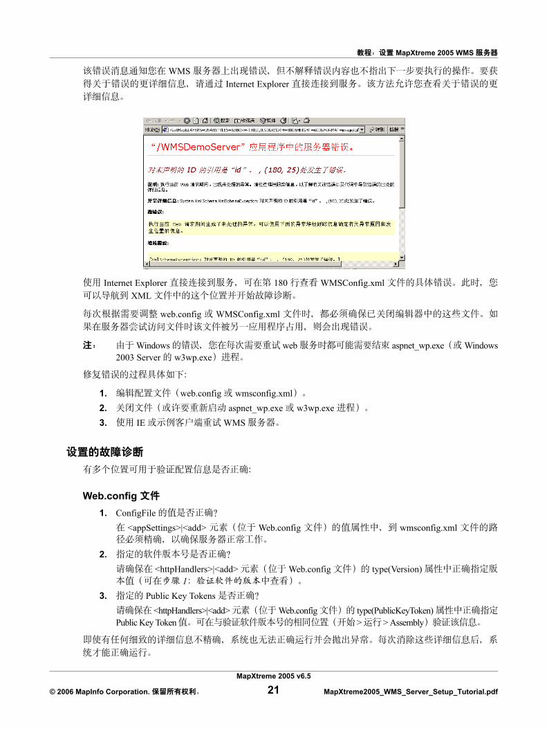
WMS Internet Explorer
Internet Explorer 180 WMSConfig.xml XML
web.config WMSConfig.xml
Windows web aspnet_wp.exe Windows2003 Server w3wp.exe
1. web.config wmsconfig.xml2. aspnet_wp.exe w3wp.exe 3. IE WMS
Web.config 1. ConfigFile
<appSettings>|<add> Web.config wmsconfig.xml
2. <httpHandlers>|<add> Web.config type(Version)
13. Public Key Tokens
<httpHandlers>|<add> Web.config type(PublicKeyToken) Public Key Token > > Assembly
MapXtreme 2005 v6.5
© 2006 MapInfo Corporation. 21 MapXtreme2005_WMS_Server_Setup_Tutorial.pdf
MapXtreme 2005 WMS
wmsconfig.xml 1. <mxp-wms:OnlineResource>
URL getmap.ashx 2. <DataSourceDefinitionSet>
id <DataSourceName> <FileName>
3. <WmsLayerList> a.
b. <mxp:FeatureLayer>
c. <DataSourceRef> ref <TABFileDataSourceDefinition>
<TABFileDataSourceDefinition> id
IIS 1.2. IIS 3. aspnet_wp.exe w3wp.exe
ASP.NET WMS ASP.NET (UNC)
\\server\data\ Z:\data
ASP.NET
IIS 5.0/5.1
ASP.NET
MYDOMAIN\WMSUser WMSUserPassword
1. Web.config 2. web.config <system.web>
<identity password="WMSUserPassword" userName="MYDOMAIN\WMSUser" impersonate="true" />
MapXtreme 2005 v6.5
© 2006 MapInfo Corporation. 22 MapXtreme2005_WMS_Server_Setup_Tutorial.pdf
MapXtreme 2005 WMS
3. WMS
web.config
MSDN
http://support.microsoft.com/default.aspx?scid=kb;en-us;329290
hotfix
http://support.microsoft.com/default.aspx?scid=kb;EN-US;329250
IIS 6.0 IIS5.0/5.1 IIS 6.0 ASP.NET
IIS 6.0
http://www.microsoft.com/technet/prodtechnol/WindowsServer2003/Library/IIS/26d8cee3-ec31-4148-afab-b6e089a0300b.mspx
MapXtreme 2005 v6.5
© 2006 MapInfo Corporation. 23 MapXtreme2005_WMS_Server_Setup_Tutorial.pdf