Embed Size (px)
Citation preview

ARCHAEOLOGISTS ON THE TOP OF THE WORLD HUNGARIAN ASSESSMENT WORK IN THE HIMALAYAS
ORSOLYA SZABÓ – ANNA SZEREDI
Even today, it is possible to fi nd in the harsh, wild land of the Himalayas the palace where the famous Hun-garian researcher Sándor Kőrösi Csoma1 (better known by the anglicized version of his name, Alexander Csoma de Kőrös) wrote the fi rst Tibetan-English dictionary. Thanks to the Csoma’s Room Foundation2, which is working to renovate the building and to develop the region, what a few years ago was a dilapidated ruin has now gone through a full rehabilitation, with the exception of the eastern wing, which is awaiting further renovation. Although the special religious signifi cance of the historic property protects it from the destructive impact of development, this cannot be said about the several hundred years old village that sur-rounds it. Since it is under no protection, the Foundation decided that it was important for professionals to work in the area and document what was still accessible. Within this context, archaeological examinations were performed around the palace in the 2013 and 2014 seasons.
1 http://csoma.mtak.hu/en/csoma-elete.htm Accessed 13 July 2016.2 http://csomasroom.kibu.hu/. Accessed 13 July 2016.
E-JOURNAL • 2016 AUTUMNHUNGARIAN ARCHAEOLOGY
www.hungarianarchaeology.hu
Figure 1: The location of the town within India
HUNGARIAN ARCHAEOLOGY E-JOURNAL • 2016 AUTUMN
Orsolya Szabó – Anna Szeredi • Archaeologists on the Top of the World 40
THE HISTORY OF ZANSKAR IN BRIEF
Zangla is a small village in the Ladakh region (the so-called Little Tibet) of Jammu and Kasmir in the north of India, located in the Zanskar River Valley, about a 9–10 day journey to the southwest of the city of Leh3.
The area’s history can be divided into three periods. The early period was from the beginning until the 10th century AD, which is followed by the medieval period until 1842, fi nally the ongoing modern era fi nish-es it.4 From the evidence of the petroglyphs found throughout the territory, settlement can be traced from the Bronze Age.5 These can also be found in the area of the fortifi ed palace of Zangla, but their typochronology is diffi cult to determine, since new petroglyphs are being created all the way up to the present day.
The fi rst people to settle in the region was probably the Dards, who were members of the Kushan Empire in the 2nd century AD6 In the 7th century, the Tibetans took power in the region,7 and in the middle of the 10th century independent kingdoms developed.8 In this period, Tibetan Buddhism began to spread, combined with elements of the earlier Bon religion.9 The founder of the independent Kingdom of Ladakh was Nyimagon, who succeeded in escaping the collapse of Tibet and established an independent state.10 Later, the kingdom was split up between his three sons. One was given the area around Mt. Sangpo, which included the territory of present-day Zanskar. As a response to the conquests of Islam in the 13th century, the region again turned to-wards Tibet, and – despite its religious diversity – retains a Buddhist majority all the way to the present day.11
In the 17th century, the ruler of Ladakh, Sengge Namgyal (1616–1642) extended his power over the neighbouring states, Zanskar and Guge,12 and established a state, which was strong and fl ourished for a brief period. However, his descendant was not able to maintain this and became fully in debt economically to Kashmir,13 though Ladakh only became a completely subject territory following the Dogra conquest.14
THE ZANGLA PALACE
The rulers of Zangla trace their family tree back to the 11th century,15 although the former palace stands empty now. The dynasty lost its power for good in the 19th century, and they were forced to relocate to the valley, the present day area of New Zangla. The kingdom was only made up of a few villages.16 The palace
3 Sándor Kőrösi Csoma’s letter to Captain Kennedy. Sabathu, 28 January 1825. In: Szilágyi, Ferenc: Kőrösi Csoma Sándor levelesládája (The mailbox of Sándor Kőrösi Csoma) (Budapest: Szépirodalmi Könyvkiadó, 1984).
4 Kiss-Csapó Gergely László: Hagyomány és modernizáció: Társadalmi s földrajzi átalakulás Ladakhban (Tradition and modernization. Social and geographic change in Ladakh). Doktori értekezés. ELTE Földtudományi Doktori Iskola, Földrajz-Meteorológia Doktori Program. (Budapest, 2009), 48–49.
5 For example, see: Thsangspa, Tashi Ldawa: Spatial Distribution of Petroglyphs of Ladakh. In: Rock Art Studies (Concept, Methodology, Context, Documentation and Conservation), Vol. I., ed. Malla, Bansi Lal (New Delhi: Indira Ghandi National Centre for the Arts/Aryan Books International, [1999] 2014), 177–205.
6 Bhasin, Veena: Ecology and Health: A Study Among Tribals of Ladakh. In: Studies of Tribes and Tribals 3 (1) (New Delhi: Kamla-Raj Enterprises, 2005), 1–13.
7 For more detail, see: Hudud al-’Alam ‘The Regions of the World’ – A Persian Geography 372 A.H. (982 AD). Translated by Vladimir Minorsky (London: Gibb Memorial Trust, 1937 [1970]).
8 Francke, A. H.: The Chronicles of Ladakh and Minor Chronicles. In: Archaeological Survey of India, New Imperial Series, Vol. 50 (Calcutta: Superintendent Government Printing, 1926).
9 Waddell, Laurence Austine: The Buddhism of Tibet or Lamaism: With Its Mystic Cults, Symbolism and Mythology, and in Its Relation to Indian Buddhism (Adamant Media Corporation, 2001).
10 Jina, Prem Singh: Ladakh – The Land and People (New Delhi: Indus Publishing Company, 1996).11 Howard, Neil: What happened between 1450 and 1550 AD? – Another question from the history of Ladakh. In: Recent
Research on Ladakh, Vol. 6, ed. Osmaston, Henry – Tsering, N. (Bristol: University of Bristol, 1997), 121–137.12 Jina, Prem Singh: Famous Western Explorers to Ladakh (New Delhi: Indus Publishing, 1995), 13.13 Kaul, H. N.: Rediscovery of Ladakh (New Delhi, Indus Publishing, 1998), 63–64.14 Kiss-Csapó: Hagyomány és modernizáció, 50–54.15 Francke, A. H.: Antiquities of Indian Tibet (Calcutta: S. Chand & Co. (P.Vt) LTD, 1926).16 The town of Padum, 30 km away, had its own ruling house. Their close relationships is proven by the fact that the current
prince of Padum married the sister of the ruler of Zangla.

HUNGARIAN ARCHAEOLOGY E-JOURNAL • 2016 AUTUMN
Orsolya Szabó – Anna Szeredi • Archaeologists on the Top of the World 41
is a characteristic Tibetan multistory building with a fl at roof and inward leaning walls. There are stables and a small entryway on the lower level. The next level up is an area crowded with zigzag little rooms for the former servants and the kitchens. Above this is the bright, open throne room, and then on the fourth story is the former library that now functions as a shrine, and a quite small room of about 10 m2, where Sándor Kőrösi Csoma once lived. Ervin Baktay, Hungarian orientalist and writer, carved the inscription ‘Csoma’s room’ into the door frame, in 1928. 17
ARCHITECTURE IN RELATION TO THE CHRONOLOGY
In Ladakh they worked with building techniques in different periods that are easily differentiated from one another. Bordering with wooden beams can be observed from the beginning of the 15th century. Rammed earth walls with plank framing and buildings of varying forms and sizes made of stones with earthen mortar were characteristic all the way to the 16th century. These structures of stone with mortar, which was later organized into rows, can be found until the last third of the 17th century, and then the earthen and stone solution again spreads in the 18th–20th century.
17 Fejes, Erik, Debreczeni, Ákos, Szeredi, Anna: The Palace of the Heavens: Zangla. Várjáró Magazin, number 25. Accessed 13 July 2016. (The measured drawings were made available to us by the Csoma’s Room Foundation.)
Figure 2: Measured drawings of the palace17
HUNGARIAN ARCHAEOLOGY E-JOURNAL • 2016 AUTUMN
Orsolya Szabó – Anna Szeredi • Archaeologists on the Top of the World 42
Three types of defensive towers are known: round, D-shaped, and square. These were related to the construction technology of the period, since the plank framed wall structure made only the square forms possible. The loopholes were rectangular or triangular, but in rammed earth walls the latter are more common.
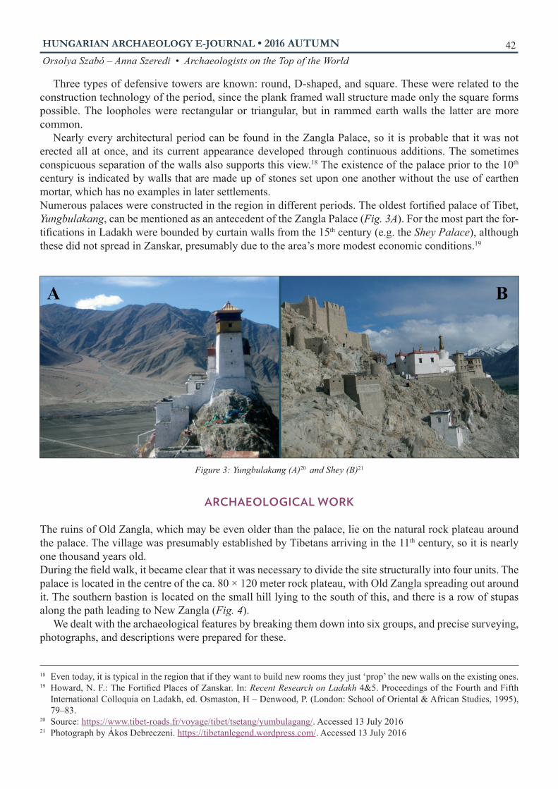
Nearly every architectural period can be found in the Zangla Palace, so it is probable that it was not erected all at once, and its current appearance developed through continuous additions. The sometimes conspicuous separation of the walls also supports this view.18 The existence of the palace prior to the 10th century is indicated by walls that are made up of stones set upon one another without the use of earthen mortar, which has no examples in later settlements. Numerous palaces were constructed in the region in different periods. The oldest fortifi ed palace of Tibet, Yungbulakang, can be mentioned as an antecedent of the Zangla Palace (Fig. 3A). For the most part the for-tifi cations in Ladakh were bounded by curtain walls from the 15th century (e.g. the Shey Palace), although these did not spread in Zanskar, presumably due to the area’s more modest economic conditions.19 20 21
ARCHAEOLOGICAL WORK
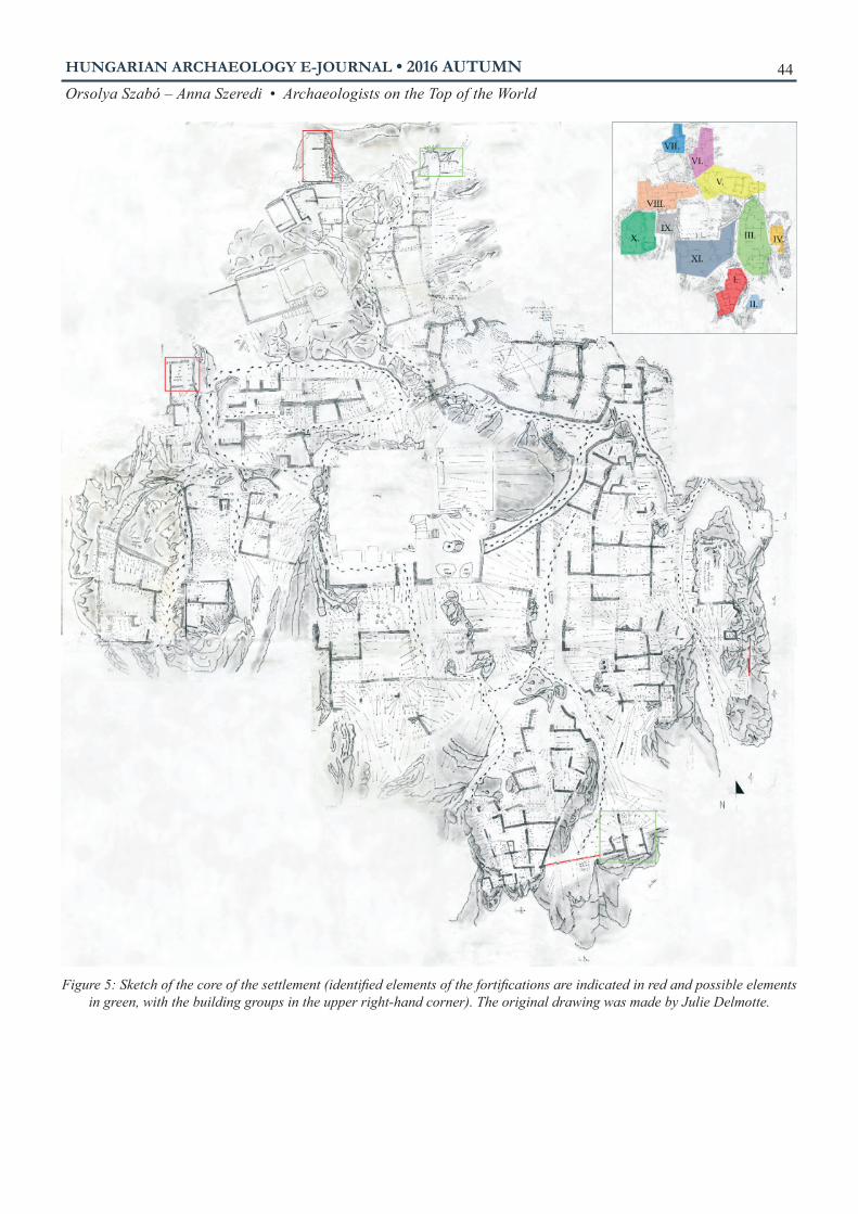
The ruins of Old Zangla, which may be even older than the palace, lie on the natural rock plateau around the palace. The village was presumably established by Tibetans arriving in the 11th century, so it is nearly one thousand years old. During the fi eld walk, it became clear that it was necessary to divide the site structurally into four units. The palace is located in the centre of the ca. 80 × 120 meter rock plateau, with Old Zangla spreading out around it. The southern bastion is located on the small hill lying to the south of this, and there is a row of stupas along the path leading to New Zangla (Fig. 4).
We dealt with the archaeological features by breaking them down into six groups, and precise surveying, photographs, and descriptions were prepared for these.
18 Even today, it is typical in the region that if they want to build new rooms they just ‘prop’ the new walls on the existing ones. 19 Howard, N. F.: The Fortifi ed Places of Zanskar. In: Recent Research on Ladakh 4&5. Proceedings of the Fourth and Fifth
International Colloquia on Ladakh, ed. Osmaston, H – Denwood, P. (London: School of Oriental & African Studies, 1995), 79–83.
20 Source: https://www.tibet-roads.fr/voyage/tibet/tsetang/yumbulagang/. Accessed 13 July 201621 Photograph by Ákos Debreczeni. https://tibetanlegend.wordpress.com/. Accessed 13 July 2016
Figure 3: Yungbulakang (A)20 and Shey (B)21

HUNGARIAN ARCHAEOLOGY E-JOURNAL • 2016 AUTUMN
Orsolya Szabó – Anna Szeredi • Archaeologists on the Top of the World 43
1. BUILDINGS
Utilizing the uneven surface of the rock, the builders created eleven groups of buildings on minor promi-nences, and these were comprised of one hundred and forty small connected houses or rooms. The streets were formed by gullies in the lower lying areas between these (Fig. 5).In most cases, they fi lled up the cracks in the plateau. The walls were placed on the fl at areas created in this way, adapting to the form of the rock and using it in the formation of the sides. Where possible they tried to make small square shapes. In less common cases, they built stone wall frames, which provided the shape of the structure, and only fi lled in the area within this, but to quite a high level (Fig. 7C). Foundations sunk into the ground are rare.
Considering the materials, there were three types of building walls: those made of stone, those made of earth, or those made using a mixed technique. Most were made in the latter manner.
The stone walls were constructed of rocks of varying sizes and using a varying amount of earthen binding material. The earliest period is indicated by structures that were built up with essentially no mortar.22 The simple walls were built from rocks irregularly stacked upon one another. Those planned to bear greater loads employed different techniques: the space between the two sides built up of large and medium sized stones was fi lled up with small rocks, pebbles, and earth. This technique appeared in Ladakh in the 17th century.23
22 Howard, N. F.: The Fortifi ed Places of Zanskar. In: Recent Research on Ladakh 4&5. Proceedings of the Fourth and Fifth International Colloquia on Ladakh, ed. Osmaston, H – Denwood, P. (London: School of Oriental & African Studies, 1995), 79–83.
23 Howard, N. F.: The Development of the Fortresses of Ladakh c. 950 to 1650 A.D. East and West 39 (1989)/4, 218.
Figure 4: The composition of the site (the southern bastion is not shown)
HUNGARIAN ARCHAEOLOGY E-JOURNAL • 2016 AUTUMN
Orsolya Szabó – Anna Szeredi • Archaeologists on the Top of the World 44
Figure 5: Sketch of the core of the settlement (identifi ed elements of the fortifi cations are indicated in red and possible elements in green, with the building groups in the upper right-hand corner). The original drawing was made by Julie Delmotte.

HUNGARIAN ARCHAEOLOGY E-JOURNAL • 2016 AUTUMN
Orsolya Szabó – Anna Szeredi • Archaeologists on the Top of the World 45
The earthen walls were made using large rammed earth elements made using plank frames. The frame-works made from planks were rectangular, 50 cm tall, 80–100 cm long and 45–55 cm wide, and were con-structed at the site (Fig. 6). It can be precisely observed how they constructed them atop one another or on the existing stone walls. This type of wall structure appeared in Zanskar in the 16th century.24 This technique is used up to the present day in New Zangla, although it is only fences that are made in this way, and with the passage of time corrugated cardboard has replaced the planks.
Walls using the mixed technique were begun with a stone structure, upon which the earthen wall was built. The stone wall was sometimes just a few rows tall, but in general the entire lower level was constructed in this manner. Their thickness was between 50–60 cm and they narrowed as they rose. However, we also observed buildings where one wall used this technique, while another wall a different one within the same structure.
Some of the houses had an upper story as well. This is indicated by the beam supports made in the walls, which sometimes still contain visible wood. Exact parallels can be observed in the present-day settlement as well. Doors were not found at a single site, and windows in only two cases (Fig. 7A, D). Presumably, the reason for this is that the area was abandoned slowly, and when they left they took everything that was salvageable. Since wood is particularly expensive here, even the door frames were removed from the abandoned houses.
24 Howard, N. F.: The Development of the Fortresses of Ladakh c 950. to 1650 A.D. East and West 39 (1989)/4, 221.
Figure 6: Rammed earth wall made using a plank frame in the past in Old Zangla (left) and today in Zangla (upper right)

HUNGARIAN ARCHAEOLOGY E-JOURNAL • 2016 AUTUMN
Orsolya Szabó – Anna Szeredi • Archaeologists on the Top of the World 46
The eleven building groups surround the palace, adapting to the natural conditions. All kinds of orienta-tions can be observed in the village in accordance with this.
Building groups I, II, III, and XI lie on the fl at area of the plateau, and these are in the worst condition. The reason for this may be that structures here were not intended to bear as great a burden. At the same time, the builders presumably fi rst used the most even areas, and thus these are the oldest parts of the village.
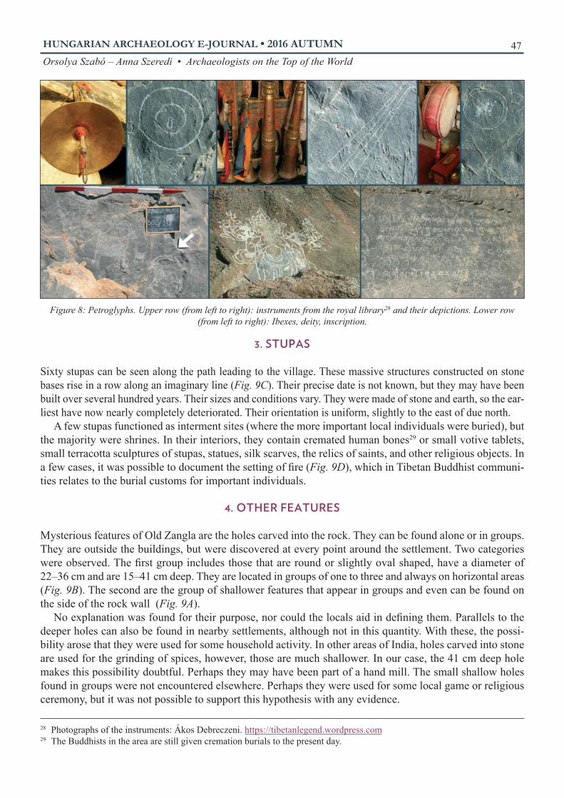
2. PETROGLYPHS
One hundred and twenty etchings were documented at the site. There are those that were etched deep and are of good quality, while other works can be observed that are sketch-like, made from a few strokes. The most common were inscriptions. Many times they were the name of some deity or the Tibetan mantra om mani padme hum, which is common practice to chisel in stone in this area. In this group there is one that can even be somewhat linked to a year. This inscription confi rms the position of a religious dignitary from the second half of the 19th century or the beginning of the 20th century (Fig. 8, lower right corner).25 The precise date of the other petroglyphs cannot be determined.
Other indications of religious life include the portrayal of instruments used in ceremonies, masks, gods, and various stupas.26 Particularly spectacular are the depictions of the ibex,27 the bearer of good luck.
25 This can be linked to the Tibetan dating cycle (a cycle is 60 years). The inscription just contains the information that it was made in an Iron-Pig year, which could have been either 1851 or 1911.
26 Buddhist burial site and reliquary. Originally, the ashes of the Buddha were interned in it, and later it slowly took on the role of a reliquary as well. Over the centuries, it slowly changed from a burial site to a sacred shrine.
27 The ibex is a wild goat, but the depictions of domesticated goats are also called ibexes in the area.
Figure 7: Buildings
HUNGARIAN ARCHAEOLOGY E-JOURNAL • 2016 AUTUMN
Orsolya Szabó – Anna Szeredi • Archaeologists on the Top of the World 47
3. STUPAS
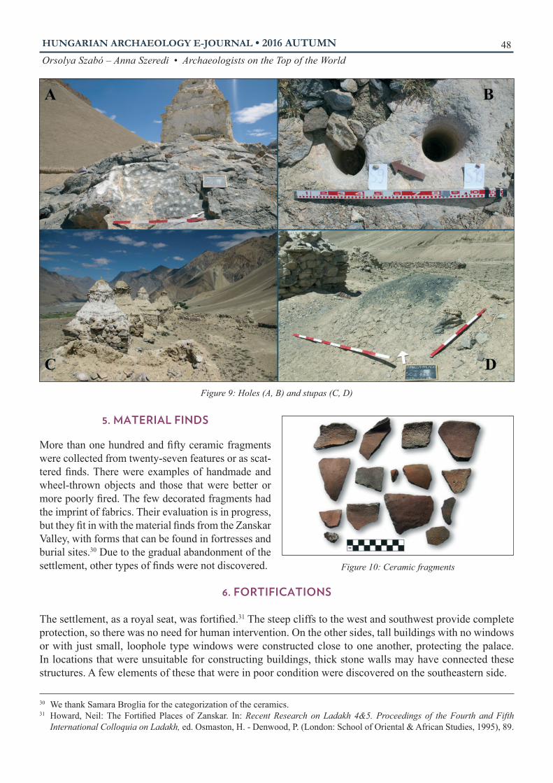
Sixty stupas can be seen along the path leading to the village. These massive structures constructed on stone bases rise in a row along an imaginary line (Fig. 9C). Their precise date is not known, but they may have been built over several hundred years. Their sizes and conditions vary. They were made of stone and earth, so the ear-liest have now nearly completely deteriorated. Their orientation is uniform, slightly to the east of due north. 28
A few stupas functioned as interment sites (where the more important local individuals were buried), but the majority were shrines. In their interiors, they contain cremated human bones29 or small votive tablets, small terracotta sculptures of stupas, statues, silk scarves, the relics of saints, and other religious objects. In a few cases, it was possible to document the setting of fi re (Fig. 9D), which in Tibetan Buddhist communi-ties relates to the burial customs for important individuals.
4. OTHER FEATURES
Mysterious features of Old Zangla are the holes carved into the rock. They can be found alone or in groups. They are outside the buildings, but were discovered at every point around the settlement. Two categories were observed. The fi rst group includes those that are round or slightly oval shaped, have a diameter of 22–36 cm and are 15–41 cm deep. They are located in groups of one to three and always on horizontal areas (Fig. 9B). The second are the group of shallower features that appear in groups and even can be found on the side of the rock wall (Fig. 9A).
No explanation was found for their purpose, nor could the locals aid in defi ning them. Parallels to the deeper holes can also be found in nearby settlements, although not in this quantity. With these, the possi-bility arose that they were used for some household activity. In other areas of India, holes carved into stone are used for the grinding of spices, however, those are much shallower. In our case, the 41 cm deep hole makes this possibility doubtful. Perhaps they may have been part of a hand mill. The small shallow holes found in groups were not encountered elsewhere. Perhaps they were used for some local game or religious ceremony, but it was not possible to support this hypothesis with any evidence.
28 Photographs of the instruments: Ákos Debreczeni. https://tibetanlegend.wordpress.com29 The Buddhists in the area are still given cremation burials to the present day.
Figure 8: Petroglyphs. Upper row (from left to right): instruments from the royal library28 and their depictions. Lower row (from left to right): Ibexes, deity, inscription.
HUNGARIAN ARCHAEOLOGY E-JOURNAL • 2016 AUTUMN
Orsolya Szabó – Anna Szeredi • Archaeologists on the Top of the World 48
5. MATERIAL FINDS
More than one hundred and fi fty ceramic fragments were collected from twenty-seven features or as scat-tered fi nds. There were examples of handmade and wheel-thrown objects and those that were better or more poorly fi red. The few decorated fragments had the imprint of fabrics. Their evaluation is in progress, but they fi t in with the material fi nds from the Zanskar Valley, with forms that can be found in fortresses and burial sites.30 Due to the gradual abandonment of the settlement, other types of fi nds were not discovered.
6. FORTIFICATIONS
The settlement, as a royal seat, was fortifi ed.31 The steep cliffs to the west and southwest provide complete protection, so there was no need for human intervention. On the other sides, tall buildings with no windows or with just small, loophole type windows were constructed close to one another, protecting the palace. In locations that were unsuitable for constructing buildings, thick stone walls may have connected these structures. A few elements of these that were in poor condition were discovered on the southeastern side.
30 We thank Samara Broglia for the categorization of the ceramics. 31 Howard, Neil: The Fortifi ed Places of Zanskar. In: Recent Research on Ladakh 4&5. Proceedings of the Fourth and Fifth
International Colloquia on Ladakh, ed. Osmaston, H. - Denwood, P. (London: School of Oriental & African Studies, 1995), 89.
Figure 9: Holes (A, B) and stupas (C, D)
Figure 10: Ceramic fragments

HUNGARIAN ARCHAEOLOGY E-JOURNAL • 2016 AUTUMN
Orsolya Szabó – Anna Szeredi • Archaeologists on the Top of the World 49
Presently it is possible to approach the cliff palace from the east. A gateway was not identifi ed, but ac-cording to locals this path always led to the entryway,32 and this area is the least steep, which was important from the aspect of leading animals up. There may have been another gateway to the north, but the road would have been too steep on the other sides.
Two bastions protected the northern side, and a third fortifi cation stood on the neighbouring hillock to the south. The walls of the western bastion, which survive to a height of 4.5 meters, provide an imposing site to the present day. It is square and constructed with a mixed technique using slatted earthen wall con-struction, which was characteristic of the 16th century.33 Only the lower level of the northern bastion has survived, which was built of large stones and the exposed cliff. Its ground plan was also square.
CONCLUSION
Old Zangla is an important site in the Zanskar Valley for several reasons. Its political role as the centre of the kingdom was crucial at times. Due to the Jumlam trade route (connecting the area with Leh, the seat of the territory) that ran alongside it, it controlled trade in the area. Its religious signifi cance is not only evi-denced by the fact that after the population had moved monks settled within its walls, but also by the fact that to the present day the locals come up here to pray, place obos amongst the ruins to appeal for protection and etch prayers into the rock. The village was built around the palace for this reason, and the splayed walls of the houses attached to one another, the bastions and the thick stone walls provided protection to the inhabitants. The structure of the settlement and the techniques employed show Tibetan architectural attributes,34 which is also underpinned by the history of the royal family. Its most distant parallels can be traced back to the fortifi ed settlements of Gyantse Dzong and Yungbulakang in Tibet. In the Zanskar Valley, the structures of Bardan35 and Basgo (Fig. 12) are most similar to the royal centre in Zangla. Based on the various building techniques, there were at least three periods of construction (in the 10th, 15th, and 16th centuries). This shows systematic use of the area over several centuries.
In the future, we will complete the full mapping of Old Zangla. It would be worthwhile to excavate one of the bastions and some of the dwellings that have survived in good condition. Some of the collapsed houses may hold a few fi nds, but it is almost certain that in the future Old Zangla will not be important for its fi nds, but instead for its settlement structure, its building techniques, and its parallels.
32 This is supported by the so-called gateway stupa constructed on the path, which is a characteristic of a path leading to a more important area.
33 Howard, N. F.: The development of the Fortresses of Ladakh c 950. to 1650 A.D. East and West 39 (1989)/4, 227.34 Hoffman, Helmut: A tibeti műveltség kézikönyve (Handbook of Tibetan Civilization) (Budapest: Terebess, 2011), 292–293.35 Howard, Neil: The Fortifi ed Places of Zanskar. In: Recent Research on Ladakh 4&5. Proceedings of the Fourth and Fifth
International Colloquia on Ladakh, ed. Osmaston, H. - Denwood, P. (London: School of Oriental & African Studies, 1995), 81.
Figure 11: The northern (B) and the western (A) bastions

HUNGARIAN ARCHAEOLOGY E-JOURNAL • 2016 AUTUMN
Orsolya Szabó – Anna Szeredi • Archaeologists on the Top of the World 50
ACKNOWLEDGEMENTS
We would hereby like to express our thanks to the Csoma’s Room Foundation and to Balázs Irimiás for the opportunity to do this research, to the Tibetologist Ákos Debreczeni for his expert assistance, and to Erik Fejes for certain photographs and graphics. 36 37
RECOMMENDED LITERATURE
HOFFMAN, HELMUT
A tibeti műveltség kézikönyve (Handbook of Tibetan civilization). Budapest: Terebess, 2011.
HOWARD, NEIL
The Fortifi ed Places of Zanskar. In: Recent Research on Ladakh 4&5. Proceedings of the Fourth and Fifth International Colloquia on Ladakh, ed. Osmaston, H. and Denwood, P., 79–99. London: School of Oriental and African Studies, 1995.
CROOK, JOHN – OSMASTON, HENRY
Himalayan Buddhist Villages, Environment, Resources and Religious Life in Zangskar, Ladakh. Bristol: University of Bristol, 1994.
Harrison, PeterFortress Monasteries of the Himalayas: Tibet, Ladakh, Nepal and Bhutan. Oxford: Osprey Publishing, 2011.
THSANGSPA, TASHI LDAWA
Spatial Distribution of Petroglyphs of Ladakh. In: Rock Art Studies (Concept, Methodology, Context, Doc-umentation and Conservation), Vol. I, ed. Malla Bansi Lal, 177–205. New Delhi: Indira Gandhi National Centre for the Arts/Aryan Books International, [1999] 2014.
36 Source: http://www.indianholiday.com/tourist-attraction/leh-ladakh/monasteries/bardan-monastery.html Accessed 13 July 2016.37 Source: https://itisemriarticles.wordpress.com/2012/08/08/v-ladakh-chronicles-a-photographic-journey-monasteries/ Acces-
sed 13 July 2016.
Figure 12: Bardan36 (A) and Basgo37 (B)