Embed Size (px)
Citation preview
SYSTEM MANAGEMENT: PRESERVATION,
MAINTENANCE AND OPERATIONS
REPORT
September 2012 Public Comment Draft

Illinois Long Range State Transportation Plan September 2012 System Management: Preservation, Maintenance and Operations Page i
Table of Contents 1.0 Introduction .................................................................................................................... 1 2.0 System Preservation & Maintenance .............................................................................. 2
2.1 Aviation .............................................................................................................................................. 2 2.2 Bicycle and Pedestrian ...................................................................................................................... 2 2.3 Highways and Bridges ...................................................................................................................... 3
2.3.1 The Current Highway Program Focus .................................................................................. 4 2.3.2 Pavement Condition Rating Program .................................................................................... 5 2.3.3 Highway Bridge Program......................................................................................................... 6 2.3.4 Truck Access Route Program ................................................................................................. 7
2.4 Public Transportation ....................................................................................................................... 7 2.4.1 Northeastern Illinois Public Transportation ......................................................................... 8 2.4.2 Downstate Transit .................................................................................................................... 9 2.4.3 Statewide Paratransit............................................................................................................... 10
2.5 Freight Rail ....................................................................................................................................... 10 2.5.1 Chicago Region Environmental Transportation and Efficiency Program ..................... 10
2.6 Intercity Passenger Rail .................................................................................................................. 11 2.7 Waterways......................................................................................................................................... 12
3.0 System Operations ........................................................................................................ 14
3.1 Communication and Information ................................................................................................. 14 3.1.1 Agency Websites ..................................................................................................................... 14 3.1.2 Real-Time Travel Conditions Websites ............................................................................... 15 3.1.3 Trip Planning ........................................................................................................................... 16 3.1.4 Highway Advisory Radio ....................................................................................................... 16 3.1.5 Dynamic Message Signs ......................................................................................................... 16 3.1.6 Rest Area Travel Information ............................................................................................... 18 3.1.7 Other Communication Tools ................................................................................................ 18
3.2 Traffic Operations ........................................................................................................................... 19 3.2.1 IDOT Operations Centers .................................................................................................... 20 3.2.2 Network Surveillance ............................................................................................................. 21 3.2.3 Ramp Metering ........................................................................................................................ 22 3.2.4 Smart Corridors and Traffic Signal Optimization .............................................................. 23 3.2.5 Signals ....................................................................................................................................... 23 3.2.6 Emergency Traffic Patrol ...................................................................................................... 24 3.2.7 Toll/Fare Collection ............................................................................................................... 25 3.2.8 Commercial Vehicle Operations ........................................................................................... 25
3.3 Construction and Maintenance Management ............................................................................. 26 3.3.1 Smart Work Zones ................................................................................................................. 26 3.3.2 Automated Work Zone Speed Enforcement ..................................................................... 27
3.4 Public Transit ................................................................................................................................... 27 3.5 Freight and Passenger Rail Shared Tracks ................................................................................... 27 3.6 System Capacity ............................................................................................................................... 28
3.6.1 Bus on Shoulder Pilot Program ............................................................................................ 28 3.6.2 Express / Reversible Lanes ................................................................................................... 28
Illinois Long Range State Transportation Plan September 2012 System Management: Preservation, Maintenance and Operations Page ii
Table of Contents (continued) 3.7 Emerging Strategies and Systems.................................................................................................. 28
3.7.1 Active Transportation and Demand Management ............................................................ 28 3.7.2 Bus Rapid Transit.................................................................................................................... 29

Illinois Long Range State Transportation Plan September 2012 System Management: Preservation, Maintenance and Operations Page 1
1.0 Introduction
Illinois has a significant investment in its transportation infrastructure. With more than 140,000 miles of roads and more than 26,400 bridges, Illinois ranks fourth in the nation in number of road miles. There are 110 airports in the State, 79 of which are public owned including O’Hare International Airport, the second busiest in the nation. Illinois has 1,095 miles of navigable waterways. The freight rail system is second nationally, with 7,792 operating miles. Amtrak, with more than 2 million riders in 2011, and Metra, the metropolitan Chicago commuter rail service provider, use those same railroad tracks with over 82.7 million riders in 2011. The CTA is the third busiest transit provider in the nation, operating rail transit on its own tracks and buses that run on city and suburban roads. Pace, Madison County Transit, MetroBus, all other transit providers, intercity buses, trucks, bicyclists and pedestrians also use the network of roads that cross Illinois. Sidewalks and multi-use trails throughout the state provide connections for pedestrians and bicycles. To facilitate this movement of people and goods, it is necessary that the infrastructure be well maintained and operated for the State’s economic well being and quality of life. IDOT and others, both public and private, are responsible for maintaining and operating this multimodal network. IDOT maintains and operates roads under its authority, and counties, townships, municipalities and the Illinois Toll Highway Authority maintain and operate roads under their jurisdiction. The transit providers are responsible for maintaining their infrastructure and vehicles. Intercity bus providers and railroads are privately owned, although the shared railroad tracks with Amtrak sometime require IDOT’s involvement. Pedestrian pathways and multi-use trails are most often the responsibility of local jurisdiction. The Illinois Department of Natural Resources (IDNR) and the US Army Corps of Engineers (Corp) manage and operate the State’s rivers, dams and locks, and the 15 waterway port districts and private companies with river landing facilities maintain their own property. IDOT’s primary responsibility is to maintain and operate the State’s road network. IDOT also distributes federal and state maintenance and operation funds for airports, Amtrak’s passenger services in Illinois, local roads and public transit.

Illinois Long Range State Transportation Plan September 2012 System Management: Preservation, Maintenance and Operations Page 2
2.0 System Preservation & Maintenance
2.1 Aviation
The Division of Aeronautics is charged with regulating and supervising aeronautics within the state. The State’s annual Airport Improvement Program (AIP) includes projects at airports to ensure continued safe and efficient operations at these facilities with a focus on creating opportunities for economic development. Since January 2009, Illinois has committed more than $251 million on more than 165 airport project agreements throughout Illinois. Current preservation and maintenance efforts at airports throughout the state include the rehabilitation of the primary runway at Quad City International Airport. The rehabilitation of this runway, which intersects the other two runways at the “bull’s eye”, will avoid any need to close all three runways at this very busy airport for the next 20-plus years. In addition, O’Hare International Airport, owned by the City of Chicago, is undergoing an intensive, long-term, $6.6 billion improvement project, the O’Hare Modernization Program. Also, Chicago/Rockford International Airport is in the process of upgrading various taxiways and runways, representing an investment of $31 million, which will reduce future maintenance needs and make the airport more efficient. The Division of Aeronautics is the sponsor of the proposed South Suburban Airport (SSA), located in Will County. The Inaugural Airport site is approximately 5,385 acres. The SSA will be a new supplemental air carrier airport, aimed at servicing Will County, Chicago’s south suburbs and beyond. The SSA will serve a vital role in the region by providing a convenient and accessible venue for commercial passenger service, cargo operations, as well as corporate and general aviation activities. While the Division of Aeronautics is the current sponsor, the Governor and General Assembly will determine the ultimate governing structure. The Airport Master Plan and Environmental Impact Statement are underway. The Federal Aviation Administration (FAA) has accepted and approved several planning reports.
2.2 Bicycle and Pedestrian
Maintenance of bicycle and pedestrian facilities depends on where the facility is located. For facilities integrated into State roads, such as paved shoulders or shared / dedicated on-road bicycle lanes, IDOT bears maintenance responsibilities, with highway funds used for maintenance. For facilities separate from the road, such as adjacent multi-use paths or sidewalks, maintenance responsibilities are often delegated to the local municipality and are defined in a Letter of Understanding between the two agencies. The local municipality or government agency will rely on a variety of funds from their budgets to maintain the facilities. On June 1, 2010, IDOT revised it bicycles and pedestrian policies to incorporate Complete Streets. The need for this change was because of Illinois legislation passed in 2007 that amended the Illinois Highway Code to give bicycles and pedestrian full consideration in the planning and development of transportation facilities.

Illinois Long Range State Transportation Plan September 2012 System Management: Preservation, Maintenance and Operations Page 3
2.3 Highways and Bridges
Prior to 2009, Illinois’ backlog of roads in need of repair was increasing significantly because the available resources were not keeping pace with the rate of deterioration. Recognizing the growing need for additional resources to maintain the roads, the State enacted the Jump Start Capital Plan and Illinois Jobs Now! funding programs. Along with federal money from the American Recovery and Reinvestment Act of 2009 and with authorization to accelerate construction, these funds enabled IDOT to reduce the backlog and repair more roads and bridges, resulting in the busiest highway construction season in Illinois history. As a result of these two funding initiatives, Illinois was able to plan to resurface nearly 2,100 miles of additional roadways and replace or rehabilitate more than 150 additional bridges. Figure 2.1 summarizes the historic and projected range of the road mileage backlog, reflecting the ebb and flow of funding over the past two decades. Figure 2.2 represents the backlog of bridges that are in need of rehabilitation.
Figure 2.1: Mileage Needs (Backlog), 1998 to 2018
2,021 1,993 1,784
1,505 1,462 1,425 1,670 1,725
2,051 2,145 2,314
1,879 1,727 1,969
2,560
3,527 3,849
4,294
4,689 4,939 5,047
1998 2000 2002 2004 2006 2008 2010 2012 2014 2016 2018Estimated
Illinois Long Range State Transportation Plan September 2012 System Management: Preservation, Maintenance and Operations Page 4
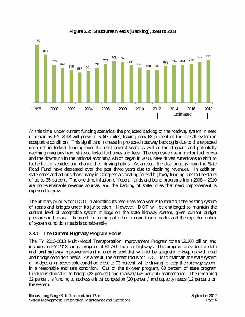
Figure 2.2: Structures Needs (Backlog), 1998 to 2018
At this time, under current funding scenarios, the projected backlog of the roadway system in need of repair by FY 2018 will grow to 5,047 miles, leaving only 68 percent of the overall system in acceptable condition. This significant increase in projected roadway backlog is due to the expected drop off in federal funding over the next several years as well as the stagnant and potentially declining revenues from state-collected fuel taxes and fees. The explosive rise in motor fuel prices and the downturn in the national economy, which began in 2008, have driven Americans to shift to fuel-efficient vehicles and change their driving habits. As a result, the distributions from the State Road Fund have decreased over the past three years due to declining revenues. In addition, statements and actions show many in Congress advocating federal highway funding cuts to the states of up to 35 percent. The one-time infusion of federal funds and bond programs from 2008 – 2010 are non-sustainable revenue sources, and the backlog of state miles that need improvement is expected to grow. The primary priority for IDOT in allocating its resources each year is to maintain the existing system of roads and bridges under its jurisdiction. However, IDOT will be challenged to maintain the current level of acceptable system mileage on the state highway system, given current budget pressures in Illinois. The need for funding of other transportation modes and the expected uptick of system condition needs is considerable.
2.3.1 The Current Highway Program Focus
The FY 2013-2018 Multi-Modal Transportation Improvement Program totals $9.168 billion and includes an FY 2013 annual program of $1.76 billion for highways. This program provides for state and local highway improvements at a funding level that will not be adequate to keep up with road and bridge condition needs. As a result, the current focus for IDOT is to maintain the state system of bridges at an acceptable condition close to 93 percent, while striving to keep the roadway system in a reasonable and safe condition. Out of the six-year program, 68 percent of state program funding is dedicated to bridge (23 percent) and roadway (45 percent) maintenance. The remaining 32 percent is funding to address critical congestion (20 percent) and capacity needs (12 percent) on the system.
1,067
881
693641
595556 581
637707
762 749687
643599 607
673 694 694 719 744781
1998 2000 2002 2004 2006 2008 2010 2012 2014 2016 2018Estimated

Illinois Long Range State Transportation Plan September 2012 System Management: Preservation, Maintenance and Operations Page 5
Most of the funding that addresses congestion and expansion needs consists of remaining funds from the Illinois Jobs Now! bond program. The condition of state highway system mileage is currently 88 percent acceptable with 92 percent of state bridges currently in acceptable condition. At the end of this proposed program, state highway system mileage is anticipated to drop to 68 percent acceptable with state bridges anticipated to be about 90 percent acceptable. The majority of the $2.5 billion local highway improvement program consists of the pass-through of federal funds for local projects. In addition to the federal funds, state funds to provide local benefit grants and local assistance remain at $431 million or at the same levels as during the Illinois FIRST capital program that ended in 2004. From the maintenance funds of $2.953 billion in the six-year program, IDOT anticipates repairing 418 miles of Interstates, 1,884 miles of US Highways and State Routes and 64 miles for safety improvements. Out of the bridge maintenance program of $1.533 billion, 134 Interstate bridges will be maintained, 374 other bridges will be repaired and 445 bridges will receive minor structural repairs. Twenty-three new bridges are also included in this program. To help identify the projects in most need of maintenance, IDOT has a number of programs and management systems in place designed to help manage and monitor the state’s roads and bridges.
2.3.2 Pavement Condition Rating Program
For decades, IDOT has made a concerted effort to track the pavement preservation needs of the more than 16,000 miles of roadways in the state highway system. IDOT conducts an annual Condition Rating Survey (CRS) of the state highway system to assess pavement conditions. In addition to providing information for IDOT on needed repairs, this information is also used by FHWA Office of Highway Policy Information as part of its Highway Performance Monitoring System (HPMS). IDOT collects data on approximately half of the state highway system each year and uses the results to determine the overall condition rating for each roadway segment on the state highway system. The condition rating is evaluated alongside other data, such as average daily traffic and the functional classification of individual roadways, to determine where the greatest needs for repair and maintenance on the state highway system are. The resulting pavement needs are assigned to two categories: “Needs Improvement” and “Acceptable.” The pavement of the highway segments in the Needs Improvement category has deteriorated to the point where an improvement is recommended immediately. Highway segments in the Acceptable category are further broken down into, “Accruing” and “Adequate.” Accruing segments are those anticipated to deteriorate and need improvement within six years of the evaluation. Adequate segments are expected to need little or no improvement within six years. The FY 2011 CRS1 showed that there are 14,025 miles (88 percent) of pavement in acceptable condition, with 1,969 miles (or about 12 percent) in the Needs Improvement category. This is an improvement from the FY 2006 CRS, which had 2,051 miles (13 percent) of roads in the Needs Improvement category. The 2011 CRS analysis estimates that about 5,035 miles (Accruing category) 1 Office of Planning and Programming. FY 2011 Condition Rating Survey Summary Report, December 2011. www.dot.il.gov/opp/FY%202011%20Condition%20Rating%20Survey%20Summary%20Report.pdf. Accessed August 7, 2012.

Illinois Long Range State Transportation Plan September 2012 System Management: Preservation, Maintenance and Operations Page 6
are expected to need improvement within the next six years. As the state highway system continues to age, construction costs increase, and funding for transportation becomes more scarce, the need for a more proactive and predictive approach will increase. Toward that end, IDOT continues to build upon the foundation that is represented by the CRS. Relying more on the predictive aspects of the CRS helps IDOT to create a system-wide approach toward preservation and maintenance that allocates available funds primarily based on need and not primarily on a strict geographic distribution.
2.3.3 Highway Bridge Program
IDOT is responsible for maintenance and safety of more than 8,0002 bridges on the Illinois state highway system. To assure that proper asset management of these structures is accomplished, IDOT utilizes a wide-ranging process that incorporates inspection and inventory data, needs analysis and funding allocation methods in order to maximize efficient and effective use of available funds. As part of this process, IDOT has set a 93 percent strategic objective for acceptable bridge condition statewide. As of October 2011, 92.4 percent of the State-maintained bridges are in acceptable condition. The Federal Highway Administration (FHWA) has developed the National Bridge Inspection Program. Federal regulations provide required inspection procedures, frequency of inspections, qualifications of personnel, inspection report content and maintenance of a state bridge inventory for all bridges more than 20 feet in length. IDOT has instituted additional requirements and procedures to assure that all structures open to public travel and under state or local responsibility are properly assessed for their adequacy to remain in service. Bridges can be structurally deficient, functionally obsolete, or both. Criteria for determining if a bridge is structurally deficient requires assessing the condition of the deck, superstructure, substructure, the culvert, the overall structural evaluation, and for water crossings, the adequacy of the waterway. Bridge functional obsolescence is determined by geometric standards, which have changed over the years since original construction. IDOT uses the Bridge Analysis and Monitoring System (BAMS) to manage its bridges. The system was developed by IDOT in the early 1980’s with input from its Office of Planning and Programming and Division of Highways; FHWA was also involved. BAMS is a program planning tool used to categorize bridges into a hierarchy of deficiency levels to help determine investment priorities for the multi-year and annual highway programs. This system is much more sophisticated than the National Bridge Inspection Program and allows IDOT to establish a priority ranking of bridge needs. This is a significant component of the program development process since safety is a primary goal and value of the State. BAMS provides 16 categories for bridge condition; the first nine dealing with backlog condition issues. The remaining seven categories are used to identify bridges that will accrue to backlog in the future.
2 The Federal Highway Administration bridge safety system accounts for bridges that are more than 20 feet in length, of which IDOT has slightly more than 7,700. IDOT has many bridges that are less than 20 feet that it is responsible for maintaining and operating, bringing the total number of bridges in the BAMS to more than 8,000.

Illinois Long Range State Transportation Plan September 2012 System Management: Preservation, Maintenance and Operations Page 7
Currently, all bridges open to traffic on the Illinois state highway system are safe. Using analysis from BAMS, 92.4 percent bridges on the system are in acceptable condition as of October 2011. This is slightly below the statewide goal of 93 percent. Table 2.1 contains information of the percent of bridges in acceptable condition and the percent of bridges in backlog condition.
Table 2.1: 2011 Bridge Needs Assessment System Type Acceptable Condition Backlog Condition
Interstate 95.4% 4.6% Non-Interstate 91.7% 8.3% Total System 92.4% 7.6%
Source: IDOT Bridge Analysis and Monitoring System, 2011.
2.3.4 Truck Access Route Program
Roads and bridges are built to standards that consider a number of design issues, including vehicle speed, anticipated travel volume and vehicle weight and size. Trucks are the vehicles that cause the most concern regarding weight and size. IDOT has enacted regulations to manage truck weight and size, with the intent of controlling the movement of vehicles that cause excessive damage3. To accommodate trucks, IDOT has designated roads as being Class I, II, or III for motor carriers, and provides maximum legal size and dimension guidelines for the various roads that motor carriers encounter. In general, Class I roads are constructed for travel by the biggest and heaviest trucks; local roads are the most restrictive for truck weight and size. To help local government agencies upgrade roads to accommodate 80,000 pound trucks, IDOT funds the Truck Access Route Program (TARP). The routes are to provide access to points for loading and unloading and to facilities for food, fuel, truck repair, and driver rest. Projects must connect to a truck route and end at another truck route or truck generator. IDOT will provide up to $45,000 per lane mile and $22,000 per intersection or up to 50 percent of the total construction cost, whichever is less. The state participation will not exceed $900,000. Each fall, IDOT solicits local projects that can be constructed during the upcoming fiscal year. This program is administered by IDOT’s Bureau of Local Roads and Streets.
2.4 Public Transportation
Public transportation preservation and maintenance programs are the responsibility of each public transportation agency. IDOT, through its Division of Public and Intermodal Transportation, supports the state’s transit providers by allocating federal and state and by providing technical assistance. Public transportation providers fall into one of two classes: large urban areas, or small urban and rural areas. The classification of service provider depends on the area’s population. Federal transportation law sets the funding programs for the two different types of providers. These funding programs are:
Urbanized Area Formula funds (known as Section 5307 funds); Capital Investments (Section 5309);
3 IDOT Legal Weight &/or Legal Dimension. www.dot.il.gov/road/Legalweight.html. Accessed June 25, 2012.

Illinois Long Range State Transportation Plan September 2012 System Management: Preservation, Maintenance and Operations Page 8
Transportation for Elderly Persons and Persons with Disabilities (Section 5310) Rural/Small Urban (Section 5311).
IDOT will use key federal, state and local funding mechanisms to meet the needs of Illinois’ transit systems. State funding often makes up the match needed to secure federal transit funds. The public transit program is divided into two parts: Northeastern and Downstate. The state makes major investments in public transportation infrastructure, with an average of 90 percent of funds going to transit needs in Northeastern Illinois with the remainder distributed to other agencies throughout Illinois.
2.4.1 Northeastern Illinois Public Transportation
The Regional Transportation Authority (RTA) consists of the Chicago Transit Authority (CTA), the Commuter Rail Division (Metra), and the Suburban Bus Division (Pace). The RTA is the planning, funding and oversight agency for the three transit operators that serve the six-county northeastern Illinois region. The CTA, Metra and Pace individually handle their respective transit operations and fare responsibilities. In 2007, the RTA presented its case for transit investment in its strategic plan entitled “Moving Beyond Congestion.” This report cited the need for $57 billion in capital investment needs over the next 30 years and laid out a specific plan for $18.35 billion in capital improvements over FY 2012-2017. The report’s proposed investment program would bring the Northeastern Illinois system into a state of good repair ($12.75 billion) and enhance and expand service to meet new demand ($5.6 billion). The plan allocated these funds among the service providers as shown below:
$13 billion – to CTA (for new rolling stock, infrastructure improvement, station modernization, communications, security systems and expansion projects)
$4.1 billion – to Metra (for new rolling stock, rehabilitation of track, ties and ballast) $1.2 billion – to Pace (for rolling stock for fixed route and paratransit service)
The funds needed to implement this program have not been secured. In 2009, Governor Quinn’s Jump Start and Illinois Jobs Now! capital programs, in addition to federal funding sources, were only able to provide $2.7 billion for transit in Northeastern Illinois. Unfortunately, the Jump Start funds have not been utilized due to the lack of reliable funding sources against which to sell bonds. The $1.8 billion Illinois Jobs Now! program for northeastern Illinois has thus far been packaged to provide almost $1.5 billion for the region’s transit systems, including $646 million for the reconstruction of the CTA’s Red Line, $585 million for new Metra Electric District railcars, and close to $40 million to Pace primarily for new rolling stock. These investments address only a portion of the RTA’s identified transit system needs. In August 2010, the RTA completed its Capital Asset Condition Assessment4, summarizing an 18-month effort to assess the condition of existing transit capital assets in northeastern Illinois and outlining its vision for moving the public transit system forward. This report states that the RTA’s
4 Regional Transportation Authority. Capital Asset Condition Assessment, August 2010. www.rtachicago.com/images/stories/final_RTA_imgs/RTA%20Asset%20Condition%20Assessment%20REPORT.pdfAccessed August 7, 2012.
Illinois Long Range State Transportation Plan September 2012 System Management: Preservation, Maintenance and Operations Page 9
ten-year capital program need is $24.6 billion, or nearly half of what the 2007 report determined was needed over 30 years. This condition assessment rated CTA, Metra, and Pace capital assets on a 1 to 5 scale, with a 1 meaning the asset was beyond its useful life, a 3 meaning that the asset was at a state of good repair (adequate, with no backlog), and a 5 meaning the asset was in excellent condition. The following summarizes the condition of the RTA system capital assets based on the 2010 condition assessment. Rail Passenger Cars (Average condition rating 2.29): 42 percent of CTA and Metra rail cars are past their useful life. At least 931 of the 2,225 rail vehicles would need to be replaced by 2019 to achieve a state of good repair, assuming continued required replacement and maintenance of the remaining rail vehicles. Passenger Train Stations (Average condition rating 3.0): 39 percent of CTA and Metra passenger stations are past their useful life. At least 150 of the 382 passenger stations would need to be renovated by 2019 to achieve a state of good repair. Assuming continued required replacement and maintenance of the remaining stations. Rail Bridges and Structures (Average condition rating 3.26): 11 percent of CTA and Metra rail bridges and structures are past their useful life. At least 151 of 1,361 bridges and structures would need to be renovated by 2019 to achieve a state of good repair, assuming continued required replacement and maintenance of the remaining rail bridges and structures. Fixed-Route Passenger Buses (Average condition rating 3.46): 16 percent of CTA and Pace fixed-route passenger buses are past their useful life. At least 457 of 2,918 buses would need to be replaced by 2019 to achieve a state of good repair, assuming continued required replacement and maintenance of the remaining fixed-route passenger buses. Rail Maintenance Facilities (Average condition rating 3.64): 14 percent of CTA and Metra rail maintenance facilities are past their useful life. At least 5 of 36 maintenance facilities would need to be renovated by 2019 to achieve a state of good repair, assuming continued required replacement and maintenance of the remaining rail maintenance facilities. Bus Garages (Average condition rating 3.37): 16 percent of CTA and Pace bus garages are past their useful life. At least 3 of 19 bus garages would need to be renovated by 2019 to achieve a state of good repair, assuming continued required replacement and maintenance of the remaining bus garages.
2.4.2 Downstate Transit
IDOT works closely with the Rural Transit Assistance Center (RTAC) at Western Illinois University and the Illinois Public Transportation Association (IPTA) to develop the annual Downstate Public Transportation Capital Needs Assessment for public transportation providers throughout Illinois (except the RTA service providers). Each fiscal year, capital asset data is collected and used to develop a needs analysis. This analysis helps to determine equipment and facility needs for all downstate transit operators. The 2009 assessment surveyed 43 agencies.

Illinois Long Range State Transportation Plan September 2012 System Management: Preservation, Maintenance and Operations Page 10
Preservation and maintenance in public transportation is known as keeping a system in a “state of good repair”. Although there is no official definition of good repair, the 2009 Downstate Public Transportation Capital Needs Assessment accounts for assets that have reached the end of their useful life and need to be replaced. The Downstate Public Transportation Capital Needs Assessment projected that $1,176 billion is needed for vehicles, facilities, technology enhancements, and other capital investments for small urban transit operators from 2009 to 2019. This projection contains a $305.3 million estimate to bring these systems to the state of good repair and a $174.1 million estimate for rural operators ten-year needs including $102.8 million for asset replacement. For St. Clair County, which provides funds for Metro services, an estimated $504.4 million is needed for the replacement of MetroLink’s bus and rail rolling stock and some facilities.
2.4.3 Statewide Paratransit
The program continues to provide federal and state capital assistance for purchasing vehicles to meet the needs of the elderly and persons with disabilities. During FY 2012, the capital program provided more than $6.57 million to purchase specialized vehicles for not-for-profit grantees or designated paratransit providers. Recipients of these vehicles may be located in either urbanized or non-urbanized areas.
2.5 Freight Rail
Freight railroads, as private companies, are responsible for all of their own maintenance and operations costs. However, IDOT plays an integral role in planning statewide freight rail projects. Through the Rail Freight and Passenger Rail Programs IDOT works to mitigate the negative impacts of rail abandonment, and facilitate economic development and job creation. . According to the Association of American Railroads, there are 41 railroad companies operating within Illinois including seven Class I railroads, three regional railroads, 12 short lines and 19 switching and terminal railroads. A railroad earning more than $398.7 million in annual operating revenue is in the Class I category. Class I railroads comprise only one percent of the number of railroads in this country but account for 69 percent of the industry’s mileage operated, 90 percent of railroad employees and 94 percent of freight revenue. A regional railroad generally operates at least 350 miles of track or earns revenue between $40 million and the Class I revenue threshold, and a short line railroad generally operates less than 350 miles. Switching and terminal railroads are primarily non-line-haul carriers and perform switching and/or terminal services for other railroads. The Rail Freight Assistance Program provides capital assistance to communities, railroads and shippers to preserve and improve rail freight service in Illinois. Local communities and businesses seeking access to adequate rail freight service normally oversubscribe this program. The current list of tentative projects exceeds $55 million. For FY 2013-2017, this program proposes $5 million from federal and state revenues for rail freight improvements.
2.5.1 Chicago Region Environmental Transportation and Efficiency Program
The Chicago Region Environmental Transportation and Efficiency Program (CREATE) program is a critical investment in Midwest railroad efficiency and Illinois’ economic future. Consisting of 70 rail and grade separation projects, CREATE will strengthen and reenergize the historical importance

Illinois Long Range State Transportation Plan September 2012 System Management: Preservation, Maintenance and Operations Page 11
of Chicago as the nation’s freight transportation hub. Every year, rail freight terminals in the metropolitan Chicago region handled one-quarter of the nation’s intermodal freight traffic, ranking the area the third busiest intermodal hub in the world. The program focuses a multi-billion dollar effort to improve Chicago’s extensive rail system by modernizing connections and grade separating highway and rail traffic. This program is aimed at increasing the efficiency and reliability of rail service within the Chicago region while also providing additional benefits to highway users through the elimination of at-grade crossing delays and other conflicts. The program utilizes a unique public-private partnership that is funded through local, state and federal sources, along with the freight railroads. Illinois Jobs Now! included $300 million for CREATE: the Association of American Railroads, representing the Class I freight carriers, increased its commitment to CREATE from $170 to $325 million; and the City of Chicago will provide $33 million. In addition, the program has also received $100 million in TIGER I and $10.44 million in TIGER IV funding from the federal government. Illinois also received funding from TIGER IV totaling 10.4 million for this program. In total, the program partners have pledged approximately $1.2 billion to the project. The total cost of the CREATE program is $3.6 billion, leaving $2.6 billion unfunded. Of this shortfall, $1.2 billion is needed for rail/highway grade separations. Slightly more than half of the remaining $1.4 billion is needed to complete four key projects included in the 75th Street Corridor Improvement Program. This latter program of projects adds several infrastructure improvements, flyovers and connectors that will benefit commuter and intercity rail passenger service, as well as freight movement.
2.6 Intercity Passenger Rail
Amtrak provides intercity passenger rail service in Illinois. As the national rail service operator, Amtrak has authority to operate on any host railroad track. Amtrak works with these railroads to ensure track conditions do not adversely affect service quality. In Illinois, the state provides for state-supported intercity rail passenger service to supplement national Amtrak service. Over the years, the state has provided an operating subsidy to Amtrak for this service. Originally based on costing formulas, the Illinois operating subsidy eventually evolved into a negotiated “fixed” cost. This has better enabled IDOT to request rail passenger service appropriations from the General Assembly without concern for potential cost increases. Over the past 13 years, IDOT has seen a marked increase in its subsidy, reflected in Table 2.2. This change in subsidy reflects the addition of eight more state-supported trains. Passenger ridership has increased markedly with the additional service options.

Illinois Long Range State Transportation Plan September 2012 System Management: Preservation, Maintenance and Operations Page 12
Table 2.2: Illinois Rail Passenger Subsidies By Year Year Expenditure 2000 $ 9,187,500 2001 $ 10,219,300 2002 $ 10,323,900 2003 $ 10,633,000 2004 $ 11,919,400 2005 $ 12,100,000 2006 $ 12,100,000 2007 $ 24,242,200 2008 $ 28,000,000 2009 $ 24,167,600 2010 $ 26,202,875 2011 $ 25,759,453 2012 $ 26,000,000
Source: IDOT, Division of Public and Intermodal Transportation (DPIT). Under the provisions of the federal Passenger Rail Investment and Improvement Act of 2008 (PRIIA), all short-distance Amtrak corridor services must become state-supported routes and states must pay the proportional costs associated with their respective corridor route. A single, nationwide standardized methodology has been established through a joint State-Amtrak working group and will allocate the operating and capital costs among the States and Amtrak. Illinois adopted the new policy in November 2011, and the Surface Transportation Board approved the Amtrak petition to implement it in March 2012. The costing methodology applies to services provided by Amtrak over routes of no more than 750 miles between endpoints. It provides for two types of expenditures:
operating expenses for routes using a formulation that defines direct route costs associated additives, and capital charges for the use of Amtrak-owned assets
The Federal Railroad Administration (FRA), the states and Amtrak are working on transition assistance to the states during the phase in of the new methodologies for route and capital costs. Implementation is expected in 2013.
2.7 Waterways
The U.S. Army Corp of Engineers is responsible for maintenance of the 1,095 miles of waterways throughout the State that are maintained for commercial navigation. There are five USACE Districts that oversee waterways in Illinois: Chicago and Louisville as part of the Great Lakes and Ohio River Division; and Rock Island, St. Louis and Memphis out of the Mississippi Valley Division. A primary goal of the Corps of Engineers is to maintain the inland waterway system for commercial navigation. Surveys of the river bottom are routinely conducted to determine where sand has accumulated in the navigation channel. Removal of this material (dredging) is accomplished with specialized equipment like a hydraulic dredge. An objective of the channel maintenance program is to use the sandy dredged material beneficially. Some of the uses are as fill material for environmental enhancement projects, to maintain recreational beaches, and for commercial and

Illinois Long Range State Transportation Plan September 2012 System Management: Preservation, Maintenance and Operations Page 13
construction materials aggregate. Long-term planning and coordination with other resource agencies is accomplished to assure that a safe, reliable navigation channel is maintained in an environmentally responsible manner. The Major Rehabilitation Program for the Locks and Dams on the Mississippi River and Illinois Waterway consists of reliability or efficiency improvements. Reliability improvements are considered when they significantly extend the physical life of a component, have direct consequences to navigation and the ecosystem, and can be economically justified by benefit-to-cost analysis. The region focuses on this method for major rehabilitation. Efficiency improvements are considered if they enhance operational efficiency of the component. Major maintenance is categorized as major repairs or improvements that do not qualify for major rehabilitation and must be funded out of the regular US Army Corps of Engineers Operations and Maintenance (O&M) budget. The remainder of the regular O&M budget dollars is used for baseline (routine) operation and maintenance. The O&M budget has not seen significant increases and has not been allowed to increase to match inflation. Currently, there are not sufficient funds to meet the needs of the Operations and Maintenance and Major Rehabilitation Programs. Major maintenance improvements not funded are added to a list of backlog maintenance. The longer repairs to the system are delayed, the more the repairs will cost in the future. Table 2.3 reflects some of the implications of not making the needed repairs on the system.
Table 2.3: Major Maintenance Need of Locks & Dams on Illinois Waterways Lock and Dam Needs Consequence of Delayed Repair Lock Miter Gates Miter gate failure would cause closure of locks to all navigation and
shipments. Auxiliary Miter Gates Continued deterioration and potential loss of pools for navigation and
ecosystem sustainability. Lock and Dam Electrical Systems
Electrical failures cause temporary power outages to lock and dam operating machinery. Such failures would impact lock operation as well as pool regulation for navigation and ecosystem sustainability.
Repair Dam Roller and Tainter Gates
Deterioration of gate structures is occurring with possible failure and inability to regulate pool for navigation and ecosystem management.
Lock and Dam Concrete Concrete supports and protects lock and dam operating machinery and gates. Concrete is deteriorating rapidly and concrete failures are more frequent creating a greater probability of damage to miter gates by transiting tows and making it more difficult to manage pools for navigation and ecosystem sustainability.

Illinois Long Range State Transportation Plan September 2012 System Management: Preservation, Maintenance and Operations Page 14
3.0 System Operations
The public’s reliance on safe, reliable and sustainable travel largely depends on the ability to effectively operate and manage the transportation system. Since the construction of the Interstate system, demographic growth and economic development have led to a steady increase in demand for transportation facilities, which has outpaced construction of new infrastructure. This increased demand has resulted in more congestion and travel delay. Unless demand declines or supply increases, congestion will expand beyond the traditional AM and PM peak-period travel times and spread to other adjoining roadways or other transportation modes. Some techniques that assist traffic operations include long standing programs such as IDOT’s deployment of the Emergency Traffic Patrol (Minutemen) service to address road incidents quickly and efficiently. Beginning in the early 1960’s, IDOT has also been using advanced technologies to improve system operations. These technologies, referred to collectively as Intelligent Transportation Systems (ITS), play a key role in the State’s efforts to improve safety and mobility while minimizing costs. Advancements in surveillance, communications, processing, and information dissemination has allowed ITS elements to detect, verify, and communicate situations affecting travel more quickly and effectively than at any time in the past. These advancements in turn have improved the manner in which the public chooses to travel, providing accurate real time information when and where it is needed most. Although these technologies come at a cost, their use and implementation represent significant savings compared to the construction of new transportation infrastructure.5 This section discusses the tools and techniques that are used by IDOT and others to operate the State’s existing transportation systems more efficiently and effectively. IDOT operates the State’s road network, while others operate the public transit, freight railroad, passenger railroad and waterways and ports systems. Discussions of the technology used in these systems are for information, and does not imply that IDOT provides these services.
3.1 Communication and Information
Accurate, relevant, and timely information can improve traveler decision-making, translating into reduced trip times, more predictable travel, an improved travel experience and most importantly, safer travel. With the internet, global positioning satellite (GPS) technology, new mapping tools, mobile communications devices, the use of social networking sites as information sources and other advances in technology, real-time traveler information is becoming more available to more users. This information can be used for pre-trip planning or be provided en-route through a number of methods. Efforts to provide travelers with accurate, relevant and timely information are detailed in the following sections.
3.1.1 Agency Websites
The internet offers significant advantages to providing traveler information. Websites are accessible at all hours, everyday and can be read from any device with an internet connection. Throughout the state, every major transportation provider (Amtrak, IDOT, the Tollway, the Chicago DOT and most
5 Illinois Statewide ITS Strategic Plan and Architecture Technical Assistance Project. www.dot.il.gov/ilits/documents.html. Accessed July 27, 2012.

Illinois Long Range State Transportation Plan September 2012 System Management: Preservation, Maintenance and Operations Page 15
public transit providers) has a website with relevant information for users, such as construction updates and alerts, system maps, schedules and routes, fares and fees, and other travel information. Based on the type of transportation, the websites also have other information related to the agency such as governance, history, programs, news releases, contracting information and contacts. IDOT has a number of websites. For travelers, IDOT has compiled a variety of information on its Getting Around Illinois website which features an interactive map and provides the following information:
Current road conditions based on weather conditions or construction Planned improvements The State’s Scenic Byways Truck routes, and other information of interest to truckers The location of bio-diesel and E-85 fueling stations Maps of Average Annual Daily Traffic and bicycling routes Links to other traveler information websites
3.1.2 Real-Time Travel Conditions Websites
Monitoring travel conditions with information systems is an on-going activity of IDOT, the Tollway and other transportation agencies. In Illinois, IDOT’s traffic information systems collects data, processes and distributes real-time traffic information for selected roads throughout the state. Other data sources for the information systems include transit providers, emergency management centers, roadway weather information and data from other state DOTs, depending upon location and coverage area. The information is processed and made available in a map-based format. Some of these road traffic conditions sites are hosted by IDOT or are contracted to a private company. The three traffic conditions information websites in the state are:
TravelMidwest.com covers metropolitan Chicago, Rockford and the Quad Cities; I-80/90/94 through northern Indiana; sections of southwest Michigan, and Milwaukee and Madison, Wisconsin.
GettingAroundPeoria.com. STL-Traffic.org covers the St. Louis region for
Illinois and Missouri, and is operated by IDOT. Both the City of Chicago and Lake County also have traffic information websites, currently shown as test sites.6 The Chicago website provides general aggregated congestion conditions, real-time travel speeds on major City roads, locations of traffic signals and the City’s red light cameras and traffic counts. The Lake County website provides real time travel speeds on major roads in the County and incorporates camera icons that provide updated snapshot views of traffic at numerous locations throughout the County. Public transit agencies also monitor vehicle locations and are beginning to relay this real-time information to transit users. This technology is currently available for a few transit systems in the
6 ChicagoTrafficTracker.com.
The TravelMidwest.com website was selected as ITS Midwest’s 2009 and 2010 Project of the Year.
Illinois Long Range State Transportation Plan September 2012 System Management: Preservation, Maintenance and Operations Page 16
State. The CTA keeps track of train locations, and the CTA, Pace, and the transit systems in Bloomington-Normal and Champaign-Urbana have in-vehicle GPS technology for their buses. The agencies share this information with users on their website or through mobile phone applications, some of which are provided by other, non-agency entities.
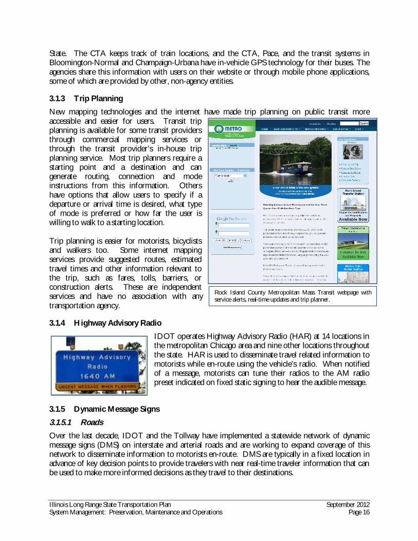
3.1.3 Trip Planning
New mapping technologies and the internet have made trip planning on public transit more accessible and easier for users. Transit trip planning is available for some transit providers through commercial mapping services or through the transit provider’s in-house trip planning service. Most trip planners require a starting point and a destination and can generate routing, connection and mode instructions from this information. Others have options that allow users to specify if a departure or arrival time is desired, what type of mode is preferred or how far the user is willing to walk to a starting location. Trip planning is easier for motorists, bicyclists and walkers too. Some internet mapping services provide suggested routes, estimated travel times and other information relevant to the trip, such as fares, tolls, barriers, or construction alerts. These are independent services and have no association with any transportation agency.
3.1.4 Highway Advisory Radio
IDOT operates Highway Advisory Radio (HAR) at 14 locations in the metropolitan Chicago area and nine other locations throughout the state. HAR is used to disseminate travel related information to motorists while en-route using the vehicle’s radio. When notified of a message, motorists can tune their radios to the AM radio preset indicated on fixed static signing to hear the audible message.
3.1.5 Dynamic Message Signs
3.1.5.1 Roads Over the last decade, IDOT and the Tollway have implemented a statewide network of dynamic message signs (DMS) on interstate and arterial roads and are working to expand coverage of this network to disseminate information to motorists en-route. DMS are typically in a fixed location in advance of key decision points to provide travelers with near real-time traveler information that can be used to make more informed decisions as they travel to their destinations.
Rock Island County Metropolitan Mass Transit webpage with service alerts, real-time updates and trip planner.
Illinois Long Range State Transportation Plan September 2012 System Management: Preservation, Maintenance and Operations Page 17
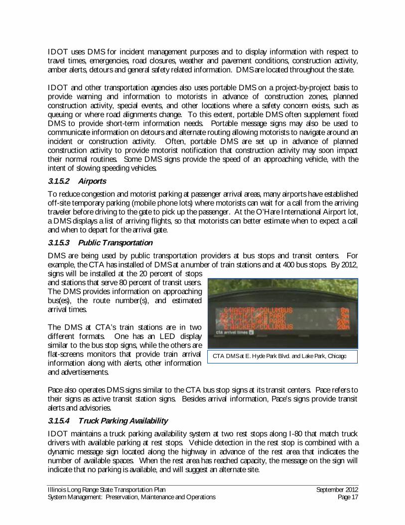
CTA DMS at E. Hyde Park Blvd. and Lake Park, Chicago
IDOT uses DMS for incident management purposes and to display information with respect to travel times, emergencies, road closures, weather and pavement conditions, construction activity, amber alerts, detours and general safety related information. DMS are located throughout the state. IDOT and other transportation agencies also uses portable DMS on a project-by-project basis to provide warning and information to motorists in advance of construction zones, planned construction activity, special events, and other locations where a safety concern exists, such as queuing or where road alignments change. To this extent, portable DMS often supplement fixed DMS to provide short-term information needs. Portable message signs may also be used to communicate information on detours and alternate routing allowing motorists to navigate around an incident or construction activity. Often, portable DMS are set up in advance of planned construction activity to provide motorist notification that construction activity may soon impact their normal routines. Some DMS signs provide the speed of an approaching vehicle, with the intent of slowing speeding vehicles.
3.1.5.2 Airports To reduce congestion and motorist parking at passenger arrival areas, many airports have established off-site temporary parking (mobile phone lots) where motorists can wait for a call from the arriving traveler before driving to the gate to pick up the passenger. At the O’Hare International Airport lot, a DMS displays a list of arriving flights, so that motorists can better estimate when to expect a call and when to depart for the arrival gate.
3.1.5.3 Public Transportation DMS are being used by public transportation providers at bus stops and transit centers. For example, the CTA has installed of DMS at a number of train stations and at 400 bus stops. By 2012, signs will be installed at the 20 percent of stops and stations that serve 80 percent of transit users. The DMS provides information on approaching bus(es), the route number(s), and estimated arrival times. The DMS at CTA’s train stations are in two different formats. One has an LED display similar to the bus stop signs, while the others are flat-screens monitors that provide train arrival information along with alerts, other information and advertisements. Pace also operates DMS signs similar to the CTA bus stop signs at its transit centers. Pace refers to their signs as active transit station signs. Besides arrival information, Pace’s signs provide transit alerts and advisories.
3.1.5.4 Truck Parking Availability IDOT maintains a truck parking availability system at two rest stops along I-80 that match truck drivers with available parking at rest stops. Vehicle detection in the rest stop is combined with a dynamic message sign located along the highway in advance of the rest area that indicates the number of available spaces. When the rest area has reached capacity, the message on the sign will indicate that no parking is available, and will suggest an alternate site.
Illinois Long Range State Transportation Plan September 2012 System Management: Preservation, Maintenance and Operations Page 18
3.1.6 Rest Area Travel Information
To improve the public’s travel experience, and to supplement efforts to disseminate traveler information, IDOT provides traveler information displays at rest areas across the state. The displays provide the following types of information:
Weather and pavement conditions Construction activity and detours Tourist and service information (i.e., restaurants, hotels, gas, etc.) Emergency alerts Road closures Incident information (at some locations)
3.1.7 Other Communication Tools
The proliferation of communication tools has been a benefit for transportation agencies and user. For example, the larger public transportation providers in Illinois communicate real-time traveler information through pre-recorded telephone messages, e-mail or text alerts, social media sites, Really Simple Syndication (RSS) feeds or subscription services.
3.1.7.1 Subscription Services E-mail subscription services are another way to engage and inform the public. In exchange for an e-mail address, users can chose to receive alerts on traffic conditions or general information based on their interest. Public transportation providers CTA, Metra, Pace, Madison County Transit, and Metro all offer e-mail notices. IDOT in Motion is another that provides periodic updates on many topics of interest including aviation, bicycling, grants, and IDOT district news. For residents of the metropolitan Chicago area, the Illinois Traffic Alert System7 provides customized traffic reports for 72 Interstate road segments. Subscribers are often given the choice to customize what information and how often they want to receive the updates.
3.1.7.2 Road Condition Hot Line IDOT offers a pre-recorded report on road conditions via telephone, at 800-452-IDOT (4368). Weather conditions and construction information is available for all non-Tollway Interstates, portions of US 20 and US 34 and on IL 394. There is also information available specifically for the Chicago metro area via telephone at 312-DOT-INFO (368-4636).
3.1.7.3 Mobile Communication Devices The growth in the use of “smart” mobile phones and the proliferation of applications (apps) that run on them is transforming transportation information. Most apps are developed by individuals or for-profit corporations and therefore are independent of any transportation agency. The most ubiquitous apps include mapping, direction and location applications. Other applications available today include numerous tools for the personal automobile including:
Car finders and remote lock & unlock Mileage logs, engine diagnostics and repair maintenance tracking Fuel efficiency monitors, fueling station locators and prices, Parking locators and payment system
7 www.iltrafficalert.com

Illinois Long Range State Transportation Plan September 2012 System Management: Preservation, Maintenance and Operations Page 19
Other apps include airplane and ship locators, flight trackers, public transportation bus and train locators, walking and bicycling route and mileage tracking, taxi locators, transportation system alerts, and services locators for motor carriers. In addition to delivering service alerts and bus / train tracking via text message or e-mail, some public transit providers offer a mobile phone interface that makes reading the agency website easier. This interface facilitates accessing the most pertinent travel information on the smaller screen of a mobile communication device. Rock Island Metro, Pace, CTA and Metra are some of the agencies that offer this mobile phone adaptation. IDOT is in the process of developing a mobile phone application also.
3.1.7.4 Social Media Over the last several years, social media websites have played an important role in the dissemination of information and the use of social media is likely expected to continue. Recognizing the value of these communication systems in sharing information and in marketing the agency, IDOT established a social media presence on Facebook and Twitter in 2009, and also use YouTube, LinkedIn and Flickr. These sites have allowed IDOT to provide traveler information to users in a quick, cost-effective manner. In addition to providing information, the sites allow two-way communication between IDOT and the public, providing the agency an immediate way to respond to the public’s questions. This has allowed IDOT to expand its relationship with the public. Public transportation agencies have also embraced the use of social media sites. Some of the larger agencies have a presence on multiple sites, and one rural transit provider uses a social media site, rather than a stand-alone website.
3.2 Traffic Operations
Intelligent Transportation System (ITS) is the integrated application of management strategies that improve mobility, capacity, and reliability, with sensors, computers, electronics and communication technologies. ITS is critical to IDOT’s ability to achieve its transportation safety and efficiency goals. There are a number of regional collaborative efforts currently underway to expand the use of ITS technologies. One activity is the Northeastern Illinois Regional Intelligent Transportation Systems

Illinois Long Range State Transportation Plan September 2012 System Management: Preservation, Maintenance and Operations Page 20
Architecture, which will guide the transportation systems integration in the six-county Chicago region over the next 15 years. The architecture was developed through a cooperative effort by the region’s transportation agencies, with active efforts from IDOT, covering all modes and all roads in the region. The architecture represents a shared vision of how each agency’s systems will work together to share information and resources to provide a safer, more efficient, and more effective transportation system for travelers in the region. A second collaborative effort is with Illinois Central Management Services, as part of the Illinois Broadband Opportunity Partnership program. To facilitate economic development opportunities occurring as a result of growth in the digital economy, the State is working to improve the broadband infrastructure in rural areas, and is doing so by installing fiber-optic cables in State road right-of-way. IDOT will have access to this new infrastructure, and will be able to expand the ITS network as a result. IDOT has long led the nation in using innovative methods and technologies to enhance freeway and highway performance. IDOT established one of the first expressway surveillance and management systems in the world by embedding sensors in the pavement of the Chicago area expressway system and by developing the Traffic Systems Center (TSC) in the 1960s. This system provided real time traffic information before the term “real time” was invented. Since that time, IDOT has recognized the need to develop and implement new ITS applications to increase the safety and efficiency of the state’s surface transportation system.
3.2.1 IDOT Operations Centers
In addition to the TSC in Oak Park, IDOT has four Operations and Communications Centers. One is located at the District 1 office in Schaumburg, one is in Peoria, one is in Springfield and the fourth is in the St Louis Metro East area. Each of these centers monitors, dispatches, and assists field forces to manage traffic through centralized incident and communications coordination year-round. Operators at the Communications Centers monitor, dispatch, and assist the Emergency Traffic Patrol (in Districts 1 and 8), IDOT maintenance, and other field forces by coordinating information with the Illinois State Police, local police and fire departments, other agencies, contractors, the news media and the general public. The Communications Centers receive real-time expressway information from the ITS system and provides monitoring and operational support for ramp metering and DMS. The Communications Center has centralized control over the HAR, closed circuit television cameras (CCTV) and in Chicago, is responsible for the Kennedy Expressway reversible lane control system. The Communications Center may operate resources of other transportation management centers such as DMS during off hours, and shares information with the real-time traffic website companies. IDOT’s Traffic Systems Center and the District 1 Communications Center collectively act as the nerve center for the management of expressways located in northeastern Illinois. The TSC monitors traffic conditions along 170 miles of expressway in real-time using devices installed along the roadway including CCTV, vehicle detectors and environmental sensors. When an incident, congestion, weather situation or other event is detected, operators at the Communications Center make decisions quickly to initiate an appropriate response. This may include notifying the public by posting messages to fixed DMS, recording messages that are played over HAR, or communicating information to the Gateway Traveler Information System for display on the Travel Midwest website,

Illinois Long Range State Transportation Plan September 2012 System Management: Preservation, Maintenance and Operations Page 21
which feeds information for the various real-time traffic conditions websites and the traveling public. The TSC is interconnected and operated from the District 1 Communications Center located in Schaumburg. The TSC manages and operates the following devices:
Vehicle detectors (2,400) Ramp meters (113) CCTV DMS (58) Portable DMS Wet pavement sensors
IDOT is currently developing a statewide system to monitor, in real-time, traffic and travel conditions along all interstates in Illinois and share the data with State and local governments and the traveling public. This program is being implemented in conjunction with the FHWA Real-Time System Management Information Program. The following information will be available for all Interstate highways in Illinois:
Construction activities affecting travel conditions, such as implementing or removing lane closures
Roadway or lane blocking traffic incident information Confirmed weather related hazardous conditions and roadway or lane closure information
updated with changes in conditions In addition, for the Chicago and St. Louis metropolitan areas, travel time information will be
available for interstate highways and routes of significance that are limited-access highways. When implemented, IDOT will be notified of traffic situations or events on all interstates in Illinois. Available information will then be reported to the public in a timely manner. The goal will be to report significant traffic incidents within 10 minutes in urban areas and 20 minutes in rural areas. The deadline for deployment of the system is November 2016. IDOT is expanding the Gateway Traveler Information System (GTIS) and the Travel Midwest website to assist in developing the necessary traveler information systems and data to comply with the FHWA requirements. The GTIS geographic coverage will be expanded to cover the remainder of the State to receive additional traveler information (weather, road construction, incident, special event, congestion, and travel time) from various IDOT highway districts. Maps will be added to the website for Peoria, Metro East (St. Louis), and Springfield. IDOT supports ITS in St. Louis and Peoria. These systems provide travelers with construction, incident, weather, and travel time/congestion information for interstates. Currently, District 8 (Collinsville) TMC, Station 1 (Springfield), District 4 (Peoria) and the District 1 Communication Center/GTIS (Schaumburg) are all 24/7 operations and will serve as information dissemination sources for traveler information.
3.2.2 Network Surveillance
The ITS devices that IDOT uses to monitor traffic at the Communications Center or TSC include sensors (in-pavement, side fire radar and Bluetooth readers) and cameras.

Illinois Long Range State Transportation Plan September 2012 System Management: Preservation, Maintenance and Operations Page 22
3.2.2.1 Vehicle Detection Vehicle detection sensors enable operators to monitor traffic volumes and congestion from a remote location. Traffic data can be stored in a database and used to enhance transportation operations, maintenance, and planning processes.
3.2.2.2 CCTV (Closed Circuit Television cameras) IDOT is using CCTV cameras installed along Illinois freeways to monitor traffic and roadway conditions in real-time from a centralized location, usually the Communications Centers. IDOT operators can monitor CCTV images and video to detect congestion, confirm incidents, and monitor weather and road surface conditions. The cameras improve agency decision making as operators can base decisions on visual observations, without having to travel to the site or receive a call from the public. Additionally, IDOT’s Bureau of Bridges and Structures operates and monitors cameras located at select bridges and other critically important structures for the same reasons. CCTV cameras have allowed IDOT to improve operations and save costs, and as a result, IDOT has been steadily increasing the number of CCTV cameras that are deployed along freeways. In Chicagoland, IDOT monitors roughly 90 centerline miles of freeway using 158 cameras. IDOT is planning to increase the number of deployed units to 400 in the coming years. IDOT is also making camera snapshot images available to the public, which is helping motorists with their route and travel decisions. There are more than 130 cameras in other parts of the State including approximately 60 in District 4 (Peoria) and 45 in District 8 (Collinsville).
3.2.2.3 Roadway Weather Information Systems (RWIS) Weather in Illinois has a significant impact on driving conditions. From cold winters with snow and ice to hot summers with severe thunderstorms and high winds, Illinois motorists experience it all. To help mitigate the impacts that weather has on travel, IDOT integrates, analyzes and disseminates data collected from a network of 60 environmental sensor stations (ESS) located throughout the state. This information is used to alert motorists to current and anticipated driving conditions. Each ESS is located at critical infrastructure along the roadway such as bridges, or at low-lying locations. These locations are susceptible to the formation of fog and ice, and are often the first to experience these conditions. The sensors continually monitor precipitation, temperature and pavement conditions. Data from each ESS is then funneled to the RWIS, which integrates the data and provides IDOT with the information needed to plan, evaluate resource needs and implement actions to clear snow and ice, and warn motorists of fog or other severe weather conditions. This improves the efficiency and safety of maintenance operations and motorists. IDOT is one of 33 states contributing Road Weather Information System (RWIS) Environmental Sensor Station (ESS) data to the U.S. DOT Clarus System. Illinois is working with Iowa and Indiana on a cooperative interstate program that will use Clarus data to enhance traveler information as well as improve communication between states.
3.2.3 Ramp Metering
Ramp metering is perhaps IDOT’s best historic example of how technology can be used to better manage traffic. IDOT first began using ramp meters in 1963 and was the first agency in the U.S. to implement such systems. Ramp meters are essentially traffic signals located along highway ramps that regulate the rate by which vehicles are permitted to enter a freeway facility. By regulating the
Illinois Long Range State Transportation Plan September 2012 System Management: Preservation, Maintenance and Operations Page 23
flow of traffic onto the freeway, ramp meters help to break up platoons of traffic entering the facility making it easier for entering motorists to find a gap in which to merge safely. By metering the entering vehicles, traffic is held on the ramp and reduces the potential for crashes, congestion at the bottom of the entrance ramp, and provides more reliable travel times. Ramp metering remains an innovative and sustainable traffic management strategy. IDOT operates 113 ramp meters throughout the state, mainly in the metropolitan Chicago area. These ramp meters are used primarily to manage recurrent congestion and to mange traffic more effectively when incidents occur.
3.2.4 Smart Corridors and Traffic Signal Optimization
The application of a mix of technologies and the commitment of multiple transportation agencies has the potential to change the way transportation corridors are operated and managed. IDOT is working with the Chicago Department of Transportation and other jurisdictions in the metropolitan Chicago area to implement various traffic signal and ITS improvements along arterials to improve corridor performance, air quality and to reduce fuel consumption. These “Smart Corridor” projects seek to implement dynamic message signs (DMS), closed circuit television cameras (CCTV), traffic signal optimization and other corridor improvements to reduce congestion. Traffic signal optimization is dependent upon ITS to function at its best. Traffic lights are timed to moderate traffic flow, with the goal to reduce delay and congestion. When an incident occurs or weather conditions disrupt normal traffic flow, the ability to adjust signal timing to respond to the new road condition is critical to managing traffic effectively. In the past, signal timing had to be adjusted on-site; with ITS, signals can quickly be adjusted from a remote location.
3.2.5 Signals
Traffic signals play a crucial role in traffic operations. Timed correctly, signals can increase roadway capacity, improve safety for all users, and make public transportation more competitive with personal vehicles in terms of travel time.
3.2.5.1 Emergency Vehicle Pre-emption Across the state, ITS is being used to improve emergency response. Improved notification, dispatch and guidance are some of the benefits that advance technology can provide. Automatic vehicle location (AVL) systems, similar to those used for transit, are being used to track and dispatch emergency vehicles. CCTV cameras located along roadways are being used to verify the location, nature and extent of collisions, and to provide emergency responders with critical details needed to determine the types of equipment and materials that may be needed when arriving at the scene of the incident. In addition, emergency vehicles are being equipped so that they can communicate with each other, to allow vehicles to proceed through signalized intersections without having to stop, thus reducing the possibility of a crash. In urban environments, emergency vehicles must often respond when congestion is present. This places the emergency responder at higher risk for involvement in crashes and introduces unpredictable delays in arriving at their destinations. To offset the effects that congestion has on emergency vehicle response times, IDOT is working closely with emergency responders and local agencies to implement traffic signal emergency vehicle pre-emption.

Illinois Long Range State Transportation Plan September 2012 System Management: Preservation, Maintenance and Operations Page 24
Emergency signal pre-emption systems work by overriding the signal cycle to favor the emergency response vehicle. For example, at a signalized intersection with pre-emption technology, the emergency vehicle can extend the green signal cycle as the vehicle approaches the intersections. These improvements are producing cost savings for local governments and the public through reduced insurance, medical costs and saved lives.
3.2.5.2 Public Transit To improve transit service and operations, IDOT is working with transit agencies across the state to implement systems that give “priority” to transit vehicles waiting at signalized intersections. Transit signal priority systems installed on transit vehicles interact with systems installed at the traffic signal to extend “green time” to allow the transit vehicle to progress through the intersection more quickly than would have otherwise occurred if the system was not in place. To this extent the transit signal priority system reduces delay and overall transit travel times, improves bus schedule adherence and generally enhances the customer’s experience and satisfaction. This system is similar to the emergency vehicle traffic signal pre-emption technology discussed previously. Although the primary purpose of traffic signal priority is to provide better transit service, it indirectly works to reduce congestion by encouraging transit use, thus reducing the number of vehicles using roadways. In the metropolitan Chicago region, IDOT is coordinating closely with the RTA, and other partners (CTA, Pace, CDOT, county transportation agencies and municipalities) to develop a Regional Transit Signal Priority Integration Plan (RTSPIP). This plan will provide a framework for the implementation of a regionally coordinated and integrated transit signal priority (TSP) system. The plan objectives include development of regional standards and guidelines for design, implementation, operation and maintenance of a multi-jurisdictional system.
3.2.6 Emergency Traffic Patrol
Traffic congestion is caused by two things: 1) demand that exceed supply (recurrent congestion) like that found during peak travel periods and 2) “non-recurring” events including crashes, disabled vehicles, debris and other road incidents. These “non-recurring” events can disrupt traffic flow resulting in unsafe, stop-and-go driving behavior. In a matter of minutes, conditions can degrade until the road becomes totally congested. To limit the impact and duration these events have on freeway operations, IDOT operates an emergency traffic patrol to assist stranded motorists, and to restore freeway operations as quickly as possible. The patrol helps to reduce congestion by locating, assisting and removing stalled or disabled vehicles from the roadway. Once these vehicles are pushed off the roadway, operators then assist motorists with minor vehicle repairs. Through these actions, the patrol reduces the impact that events have on traffic flow and help to improve safety and mobility on the highway. The emergency traffic patrol program is a key component of the incident management service provided on the regional expressway system in the Chicago and St. Louis metropolitan areas. In Chicago, the service operates 24/7 and provides more than 120,000 assists annually. The patrol trucks are equipped with advance technology “quick tow” devices to reduce response times and enhance operator and motorist safety. The enhanced incident management program improves overall system reliability and optimizes system performance. The emergency traffic patrol is supported by ITS. For instance, emergency traffic patrol vehicles are

Illinois Long Range State Transportation Plan September 2012 System Management: Preservation, Maintenance and Operations Page 25
equipped with automatic vehicle location (AVL) tracking units, which allow for operators at IDOT’s Communication Center to dispatch a nearby vehicle to an incident. Combined with CCTV, the Communication Center can supply the ETP driver with additional information about the incident. The ETP helps restore traffic flow and reduces the chances of secondary incidents at the location.
3.2.7 Toll/Fare Collection
Non-cash toll/fare collection on tollways or public transit is accomplished through the use of new revenue collection technologies. For open-road tolling, transponders are used and for public transit, “smart” cards are the method of fare collection. These collection methods reduce traveler delay by eliminating the wait at the toll booth or when boarding. In addition, the opportunity for fraud at the collection site is reduced and operating costs can be lowered by eliminating the need for collection staff and cash processing. Users can be assured that if the transponder or smart card is lost, the account balance can be recovered. Lastly, new data sources on demand and travel patterns become available, due to the ability to track transponder or smart card/credit card use.
3.2.7.1 Open Road Tolling Open road tolling uses ITS technology to collect toll fares electronically. Open road tolling uses transponder technology, which involves two devices that emit low-level radio frequency signals. The collection transponder emits a signal to the in-vehicle device, which transmits billing account information, and deducts the toll from the account.
3.2.7.2 Public Transit Fare collection for public transit users is done in a number of ways throughout the state, and includes simple cash to encoded “smart” cards that deduct the fare from pre-established accounts. Some transit providers collect when boarding; others use an on-your-honor system, requiring that tickets be purchased and shown upon request. “Smart” transit cards are similar to the transponder technology for open-road tolling: one device (the transit fare box) communicates with another (the smart card) to collect the fare or toll. The CTA and Pace are implementing an open fare system that will allow the use of rider’s own credit/debit cards, new, reloadable cards and eventually compatible cell phones in 2014
3.2.8 Commercial Vehicle Operations
Illinois is also using ITS to improve commercial vehicle operations. ITS technology in commercial vehicles and along the roadside are helping to improve safety and efficiency, while reducing the paperwork that would otherwise be needed to enforce and regulate operations. Illinois is using a commercial vehicle information system and network (CVISN) to assist in the regulation and enforcement of commercial vehicle operations. The CVISN is used to exchange motor carrier safety and credential administration data with other state and federal agencies.
3.2.8.1 Motor Carrier Enforcement Ensuring that motor carriers are in compliance with the State’s weight and size regulations is the responsibility of the Illinois State Police (ISP). The ISP monitors truck weight and size with weigh stations located on the Interstate and more recently by using weigh-in-motion (WIM) technology.

Illinois Long Range State Transportation Plan September 2012 System Management: Preservation, Maintenance and Operations Page 26
Motor carriers can avoid penalties for overages by applying for a permit through IDOT and paying a fee8. Permits are available for trucks, with non-divisible loads that will be over-weight, over-size or need to operate on roads that are restricted. Fees depend on distance, number of axles, and overages, and vary from $5.00 to $280.00 or more if additional permits are necessary. IDOT maintains a page on its website that helps motor carriers with the fee calculation. 9
3.2.8.2 PrePass: Automatic Vehicle Identification E-Screening and Weigh-in-Motion IDOT is working to improve the overall safety of commercial vehicle traffic in the state. As a part of this effort, IDOT has installed Automatic Vehicle Identification (AVI) e-Screening sites along highways throughout Illinois, as part of its participation in the national PrePass program. The PrePass (AVI) system enables participating transponder-equipped commercial vehicles to be pre-screened throughout the nation at designated weigh stations, commercial vehicle inspection facilities, port-of-entry facilities, and agricultural interdiction facilities. Cleared vehicles are then able to "bypass" the other weigh stations between their screening location and their destination, eliminating the need to stop, saving time, wear, and fuel. The AVI e-screening system consists of overhead antennas and roadside cameras, coupled with in-vehicle transponders. Vehicles participating in the PrePass program are pre-certified; and weight, safety records, and credentials are routinely verified with state and federal agencies to ensure adherence to the safety and bypass criteria established by PrePass and member states. If an approaching PrePass-equipped vehicle’s weight, safety record, and credentials are found to be satisfactory, a green light and audible signal from the windshield mounted PrePass transponder advises the driver to bypass the weigh station. Otherwise, a red light and audible signal advise the driver to pull into the weigh station for regular processing. IDOT operates 20 weigh stations with weigh-in-motion (WIM) technology throughout the state. Weigh-in-motion systems are designed to measure the vertical forces applied by commercial vehicles using sensors in the roadway, thereby providing an estimate of the axle weight. WIM data is used for:
Secondary weight enforcement Calculating equivalent axle load for pavement and bridge design Calculating average annual daily traffic (AADT) volumes and generating vehicle classification
reports Meeting federal requirements
3.3 Construction and Maintenance Management
3.3.1 Smart Work Zones
For over 10 years, IDOT has been making work zones “smarter” through use and application of technology. A “smart” work zone employs portable dynamic message signs, traffic sensors and CCTV linked via wireless communications to a central workstation. The workstation monitors traffic using the sensors that collect lane-by-lane vehicle speeds, volumes and occupancy data. This data is then analyzed automatically by the workstation and, based on predetermined thresholds, the
8 IDOT Informational Forms. Accessed June 25, 2012. www.dot.il.gov/road/infoforms.html. 9 IDOT Permits Online Application. Accessed June 25, 2012. permits.dot.state.il.us/permits/Estimatefee.aspx

Illinois Long Range State Transportation Plan September 2012 System Management: Preservation, Maintenance and Operations Page 27
system generates messages for the portable DMS. To this extent, the system provides motorists with advance warning of construction activity and real-time conditions occurring within the work zone. For instance, with advance knowledge the motorist may elect to take an alternate route or exit the freeway until congestion within the work zone subsides.
3.3.2 Automated Work Zone Speed Enforcement
In a road construction work zone, with narrowed, shifting lanes and workers moving about, speeding creates a safety hazard. Recently, IDOT began deployment of a camera surveillance system in construction zones to enforce speed limit laws. The goals of this technological initiative are to reduce crashes and the associated injuries/fatalities to both motorists and construction workers. IDOT is one of the first transportation agencies to implement such a program. The specially equipped vans have cameras and speed detection equipment used to identify speeders and take a picture of the vehicle’s license plate. A traffic ticket is then issued by the Illinois State Police to the owner of the vehicle. This form of automated enforcement is used at high-risk locations, where workers are the most vulnerable to high volume traffic.
3.4 Public Transit
Public transit providers also use Automatic Vehicle Location (AVL) systems. Knowing where vehicles are located at any point in time is important for transit systems, to ensure schedule adherence. AVL sensors installed on transit and maintenance vehicles are used to communicate with Global Positioning System (GPS) to provide real-time vehicle location. The information is then used by transit agencies to dispatch buses as needed to bolster service on a route, mitigate bus bunching due to unforeseen delays and provide real-time travel information to transit users.
3.5 Freight and Passenger Rail Shared Tracks
Positive Train Control (PTC) systems are integrated command, control, communications and information systems for monitoring train movements with safety, security, precision and efficiency. PTC relies on wireless communications and GPS sensors installed on trains to continuously monitor train positions and verify that trains are operating within the appropriate and authorized section of track. If the system detects unauthorized movements, the system can automatically implement real-time corrective actions prevent:
Train-to-train collisions; Over speed derailments; Work zone incursions; and Wrong way movements.
PTC systems reduce incidents due to operator error. Although these systems can be automated, they includes a map display that allows dispatchers to actively monitor train movements in real-time, and operating rules and procedures or take corrective actions. Per federal mandate, positive train control systems must be installed on tracks that carry passengers and hazardous materials by 2016. IDOT is working with railroads to implement positive train

Illinois Long Range State Transportation Plan September 2012 System Management: Preservation, Maintenance and Operations Page 28
control systems throughout the state. Besides the obvious safety benefits, PTC systems allow for decreased train spacing. This helps to increase train capacity on high-density corridors.
3.6 System Capacity
3.6.1 Bus on Shoulder Pilot Program
Adding new capacity in the form of new lanes is often needed to achieve transportation goals and objectives. However, in many instances, more can be done to increase the efficiency of existing pavement. For example, IDOT is conducting a two-year bus on shoulder demonstration on I-55 between Kedzie Avenue and I-355 in metropolitan Chicago. The nearly continuous 12 foot wide shoulder in the demonstration section can be used to alleviate some of the recurring congestion that this corridor experiences during the morning and afternoon peak commuting periods. In this case, the paved shoulder represents additional capacity that was not being used efficiently. IDOT worked with Pace, the RTA and the Illinois State Police to evaluate and implement this pilot program along I-55. Implemented in November 2011, the program allows Pace express buses to bypass congestion during peak travel periods when travel speeds are less than 35 mph. Even though the buses may not travel more than 15 mph above the prevailing traffic flow, the reduced delays enhance riders’ experience by offering more reliable travel times. This program will help to move greater numbers of people through congestion much more quickly and cost effectively than constructing new lanes.
3.6.2 Express / Reversible Lanes
With 343,000 vehicles per day at some locations, the Kennedy Expressway is one of Illinois’ most congested freeways. To provide additional capacity along this facility, IDOT operates a reversible express lane system comprised of two lanes located within the median of the expressway. The reversible lanes extend for approximately 6.27.5 miles from the Ohio Street interchange on the south to the I-90/I-94 junction on the north. The lanes, which are remotely controlled by operators at IDOT’s Region 1 Communications Center, provide additional capacity to accommodate the demand during the morning and evening peak travel periods. The lanes generally switch directions twice a day Monday through Friday. Lanes switch from inbound to outbound sometime between 11:30 A.M. and 1:30 P.M. and return from outbound to inbound between 11:00 P.M. and 1:00 A.M. Traffic congestion, special events major incidents or accidents and maintenance activities can all factor in the scheduling of when a directional switch occurs.
3.7 Emerging Strategies and Systems
3.7.1 Active Transportation and Demand Management
The principle aspect of Active Transportation and Demand Management (ATDM) is to dynamically manage and control traffic using and integrating strategies. This implies an approach that uses available technology to make operational changes before conditions warrant a response to them. In
IDOT’s Kennedy Expressway Reversible Lane system was featured in a Japanese television show call “Amazing Infrastructure from Around the World.”

Illinois Long Range State Transportation Plan September 2012 System Management: Preservation, Maintenance and Operations Page 29
the future, IDOT may look to ATDM strategies to improve safety, increase efficiencies, improve traffic flow and reduce congestion ATDM strategies are more common in Europe but in recent years, have begun to be implemented within the U.S. Transportation agencies are seeking ways to dynamically manage recurrent and non-recurrent congestion based on prevailing traffic conditions. ATM traffic management strategies can be combined with demand management strategies.
3.7.2 Bus Rapid Transit
Bus Rapid Transit (BRT) is an innovative, high capacity, lower cost public transit solution that combines the flexibility of buses with the efficiency of rail. To this extent, BRT is a special form of bus service that is oriented toward providing faster, more efficient, and more reliable service than traditional bus service and can be implemented at much lower cost compared with light rail. In 2009, the CTA, in cooperation with the Chicago Department of Transportation, began studying and subsequently implementing BRT on high ridership corridors throughout the City of Chicago. BRT will connect these corridors with key destination points such as employment centers, shopping destinations, rail stations and CTA transfer points. The CTA is expected to begin operating BRT on the Jeffery Corridor from 67th Street to 103rd Street in 2012. The CTA is also studying the application of BRT on the Western Avenue Corridor (Western and Ashland Avenues) from Howard to 95th Street. Construction of the Western Avenue BRT would not begin until 2015. Various ITS elements including, automatic vehicle location, transit signal priority and pre-board fare collection systems are typically integrated within BRT applications and used to satisfy operational goals and objectives.