Embed Size (px)
Citation preview

The Faculty of Exact Sciences and Engineering
SYLLABUS TOPOGRAPHY 1
Course Code: IG 1105 Type of course: compulsory
Language of instruction: English tutoring available for Erasmus students Name of lecturer: Ioan IENCIU, PhD Seminar tutor: Luciana OPREA, PhD
Full time studies
Form of instruction Number of teaching hours per semester
Number of teaching hours per week
Semester Form of receiving a credit for a course
Number of ECTS credits allocated
Class 56 4 Autumn Grade 5
COURSE AIMS: The final objectives of the course for 1st semest refereas to the preparation of field activities, field recognition, measurement planning, measurements and the calculations. Progress in building surveying and geodetic instruments, positioning the emergence of modern technologies should be presented in the course, meeting the requirements of a modern higher education. The specific objectives: - knowledge of surveying equipment; - making topographic measurements. ENTRY REQUIREMENTS: - COURSE CONTENTS: Course contents:
1. Object of discipline; 2. Notions of measurement error theory; 3. Planimetry; 4. Benchmarking; 5. Direct measurement of distances; 6. Angles measuring; 7. Indirect measurement of distances; 8. Triangulation networks; 9. The calculation of triangulation networks orientation; 10. The increasing of triangulation networks.
Laboratory contents: 1. Notion of Safety in Surveying; 2. Math in surveying; 3. Benchmarking alignments, Direct measurement of distances; 4. Theodolite - verification, measurements; 5. Measurement of horizontal angles - Simple Method; 6. Measurement of horizontal angles - method of repetition; 7. Measurement of horizontal angles - method of reiterations; 8. Measurement of horizontal angles - method of horizon tour and binary series; 9. Measurement of vertical angles; 10. Distances measuring - Tacheometric Method; 11. Distances measuring - Parallactic Method; 12. Distances measuring - Trigonometric Method; 13. Electronic measuring distances; 14. Test of the lab.
TEACHING METHODS: Instruction is a combination of lectures, conversation and theoretical and practical examples LEARNING OUTCOMES: C1. Designing and building networks for space geodetic topographical, cadastral and other engineering works C5. Determination of displacements and deformations of buildings and lands. C6. Making cadastre information systems and specialized fields, and their use for real estate advertising works and the property valuation.

The Faculty of Exact Sciences and Engineering
LEARNING OUTCOMES VERIFICATION AND ASSESSMENT CRITERIA: Exam at least 2 test subjects - oral / written examination and Partial test (60% of the final grade) Test of the lab - practical (40% of the final grade) RECOMMENDED READING:
• Deaconescu, C. - Topografie şi desen tehnic, Editura Didactică Pedagogică, Bucureşti, 1979; • Dima, N . ş.a. - Topografie minieră, Editura Corvin , Deva, 1996; • Dima, N. ş.a. – Topografie generală şi elemente de topografie minieră, Editura Universitas, Petroşani, 2005; • Leu, N. I. ş.a - Topografie şi Cadastru Editura Universul, 2002; • L. Oprea, I. Ienciu – Topografie I - îndrumător de laborator, Seria „Didactica”, Universitatea „1 Decembrie
1918”, Alba Iulia, 2009; • L. Oprea – Topografie - îndrumător de proiect, Seria „Didactica”, Universitatea „1 Decembrie 1918”, Alba
Iulia, 2009; • Pădure, I.; Kovacs L. - Topografie Generală, Editura Risoprint, Cluj Napoca, 2005; • Russu, A. - Topografie cu elemente de geodezie şi fotogrammetrie, Editura Agrosilvică, Bucureşti, 1968.
The Faculty of Exact Sciences and Engineering
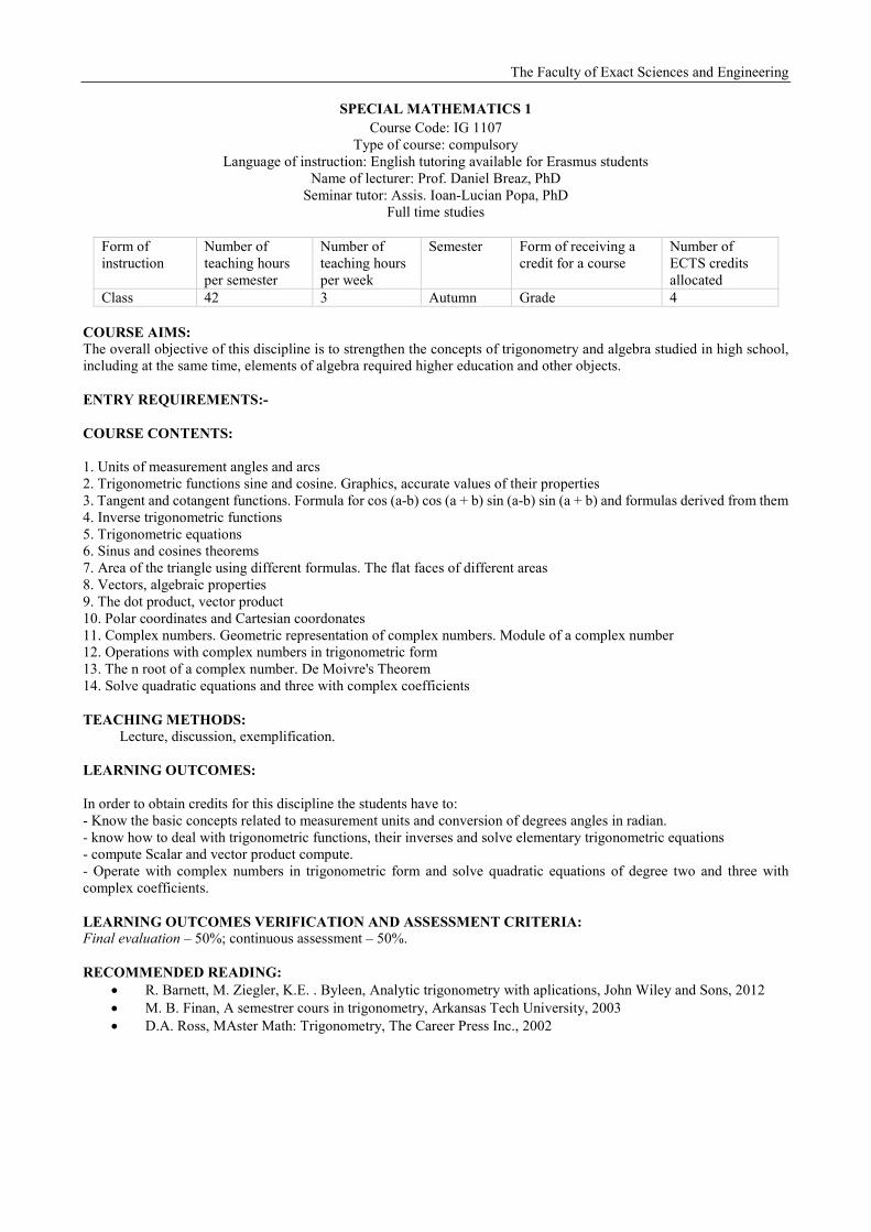
SPECIAL MATHEMATICS 1 Course Code: IG 1107
Type of course: compulsory Language of instruction: English tutoring available for Erasmus students
Name of lecturer: Prof. Daniel Breaz, PhD Seminar tutor: Assis. Ioan-Lucian Popa, PhD
Full time studies
Form of instruction
Number of teaching hours per semester
Number of teaching hours per week
Semester Form of receiving a credit for a course
Number of ECTS credits allocated
Class 42 3 Autumn Grade 4
COURSE AIMS: The overall objective of this discipline is to strengthen the concepts of trigonometry and algebra studied in high school, including at the same time, elements of algebra required higher education and other objects. ENTRY REQUIREMENTS:- COURSE CONTENTS: 1. Units of measurement angles and arcs 2. Trigonometric functions sine and cosine. Graphics, accurate values of their properties 3. Tangent and cotangent functions. Formula for cos (a-b) cos (a + b) sin (a-b) sin (a + b) and formulas derived from them 4. Inverse trigonometric functions 5. Trigonometric equations 6. Sinus and cosines theorems 7. Area of the triangle using different formulas. The flat faces of different areas 8. Vectors, algebraic properties 9. The dot product, vector product 10. Polar coordinates and Cartesian coordonates 11. Complex numbers. Geometric representation of complex numbers. Module of a complex number 12. Operations with complex numbers in trigonometric form 13. The n root of a complex number. De Moivre's Theorem 14. Solve quadratic equations and three with complex coefficients TEACHING METHODS: Lecture, discussion, exemplification. LEARNING OUTCOMES: In order to obtain credits for this discipline the students have to: - Know the basic concepts related to measurement units and conversion of degrees angles in radian. - know how to deal with trigonometric functions, their inverses and solve elementary trigonometric equations - compute Scalar and vector product compute. - Operate with complex numbers in trigonometric form and solve quadratic equations of degree two and three with complex coefficients. LEARNING OUTCOMES VERIFICATION AND ASSESSMENT CRITERIA: Final evaluation – 50%; continuous assessment – 50%. RECOMMENDED READING:
• R. Barnett, M. Ziegler, K.E. . Byleen, Analytic trigonometry with aplications, John Wiley and Sons, 2012 • M. B. Finan, A semestrer cours in trigonometry, Arkansas Tech University, 2003 • D.A. Ross, MAster Math: Trigonometry, The Career Press Inc., 2002

The Faculty of Exact Sciences and Engineering
GEODESIC INSTRUMENTS AND LAND SURVEYING METHODS Course Code: IG 1202
Type of course: compulsory Language of instruction: English tutoring available for Erasmus students
Name of lecturer: Ioan IENCIU, PhD Seminar tutor:
Full time studies
Form of instruction
Number of teaching hours per semester
Number of teaching hours per week
Semester Form of receiving a credit for a course
Number of ECTS credits allocated
Class 56 4 Summer Grade 4
COURSE AIMS: The general objectives of this course are: - the ability to collect, manage and process topographic information; - the ability to adapt to new situations, showing creativity. Progress in building surveying and geodetic instruments are subject to outstanding achievements in the fields of mechanics, physics, mathematics, electronics, etc.. Responding to this need, the course aims to present the main types of tools used in this field with emphasis on specific instruments surveyor work. ENTRY REQUIREMENTS: - COURSE CONTENTS:
1. Introduction, object of discipline; 2. Instruments for direct measurement of distances 3. Instruments for angles measuring; 4. Instruments for level difference measuring; 5. Instruments for level difference measuring - verification and calibration; 6. Electronic Instruments - verification, calibration, rectification; 7. Electronic theodolites; 8. Electronic levels; 9. Eotal Stations; 10. GPS; 11. Instruments for determining the size of surfaces.
TEACHING METHODS: Instruction is a combination of lectures, conversation and theoretical and practical examples LEARNING OUTCOMES: C2. Making topographical required to develop specific plans and topographic and thematic maps. LEARNING OUTCOMES VERIFICATION AND ASSESSMENT CRITERIA: Exam at least 2 test subjects - written examination (60% of the final grade) Test of the lab - practical (40% of the final grade) RECOMMENDED READING:
• Bianu, V. - Opticã geometricã, Editura Tehnicã Bucureşti, 1962; • Deaconescu, C. - Topografie şi desen tehnic, Editura Didactică Pedagogică, Bucureşti, 1979; • Ienciu, I.; Oprea, L.; Voicu, G. E.; Borşan, T. – Instrumente geodezice şi metode măsurare – îndrumător de
laborator, Seria Didactica, Universitatea „1 Decembrie 1918” Alba-Iulia, 2009; • Neamţu, M.; Ulea, E.; Atudorei, M.; Boceanu, I. - Instrumente Topografice şi Geodezice, Editura Tehnicã
Bucureşti, 1982; • Manual de utilizare al staţiei totale; • Manual de utilizare al teodolitului electronic; • Manual de utilizare al GPS.
The Faculty of Exact Sciences and Engineering
TECHNICAL AND CARTOGRAPHIC DRAWING
Course Code: IG 1203 Type of course: compulsory
Language of instruction: English tutoring available for Erasmus students Name of lecturer: Popa Dorin Victor, PhD
Seminar tutor: Popa Dorin Victor, PhD Full time studies
Form of instruction
Number of teaching hours per semester
Number of teaching hours per week
Semester Form of receiving a credit for a course
Number of ECTS credits allocated
Class 42 3 II Grade 4
COURSE AIM: Knowing the basics on the technical design’s purpose and importance COURSE CONTENTS: 1. General considerations; introduction to technical drawing 2. General standards used in technical drawing 3. Indicators and folding in technical drawing 4. Scales used 5. Projections layout and representation 6. Views and sections representation 7. Sections classification and tears/hatches representation 8. Dimensioning in the technical design 9. Elements of technical and cartographic drawing 10. Elements of mapping writing 11. Mapping the land originals of topographic maps and plans TEACHING METHODS: Lecture, conversation, exemplification. LEARNING OUTCOMES
- Knowing and applying the general standards of technical design - Developing the technical writing skills - Developing skills for representing various objects in view and in section - The ability to draw up the sketch and the survey for an existing object - Acquiring the ability to draw up the plan for drafting the maps and the topographical plans
LEARNING OUTCOMES VERIFICATION AND ASSESSMENT CRITERIA: Written test examination - 60%, Verification during the semester- 40%. RECOMMENDED READING:
• Leu, I.N. si colab, Topografie si cadastru agricol, Didactic and Pedagogic Publishing House, Bucharest,2000 • Achim, M, - Geometrie descriptiva si desen tehnic, Didactica series, Alba Iulia, 2004; • Ionasec, A., Radulescu, M si colab – Topografie si Desen Tehnic, Didactic and Pedagogic Publishing House,
Bucharest, 1980. • Precupetiu, P. si colab, T, Desen Tehnic Industrial, Didactic and Pedagogic Publishing House, Bucharest,
1982; • STAS 103-84- Linii utilizate in desenul industrial; • STAS 1434-83- Linii utilizate in desenul de construcţii • SR ISO 7200:1994 Indicatorul formatelor de desen tehnic • SR ISO 5457:1994 Formatele de desen tehnic
The Faculty of Exact Sciences and Engineering
TOPOGRAPHY 2 Course Code: IG 1204
Type of course: compulsory Language of instruction: English tutoring available for Erasmus students
Name of lecturer: Ioan IENCIU, PhD Seminar tutor: Luciana OPREA, PhD
Full time studies
Form of instruction
Number of teaching hours per semester
Number of teaching hours per week
Semester Form of receiving a credit for a course
Number of ECTS credits allocated
Class 56 4 Summer Grade 5
COURSE AIMS: The final objectives of the course for 1st semest refereas to the preparation of field activities, field recognition, measurement planning, measurements and the calculations. Progress in building surveying and geodetic instruments, positioning the emergence of modern technologies should be presented in the course, meeting the requirements of a modern higher education. The specific objectives: - knowledge of surveying equipment; - making topographic measurements. ENTRY REQUIREMENTS: -
COURSE CONTENTS: Course contents: 1. thickening topographic triangulation networks - intersection before 2. Thickening topographic triangulation networks - intersection back 3. Networks topographic suspended 4. Networks complete topographic 5. Networks and acolytes topograficenodale 6. Study precision topographic networks 7. Raising details planimetric 8. Calculation surfaces 9. Detaching surfaces 10. leveling (terrestrial elevation) 11. Raising the elevation details 12. leveling traverses 13. The preparation of topographical plans 14. Drawing profiles Laboratory contents: 1. Calculation Guidelines 2. Calculation sides and coordinates 3. The intersection before. solving trigonometric 4. The intersection before. solving analytical 5. Intersection back. solving trigonometric 6. Intersection back. Express Hansen 7. Intersection back. Express coordinates barycentre 8. Network topographical suspended 9. Complete Topographic Network 10. Topographic Nodal Network 11. Closure of planimetric details and calculation surfaces 12. Leveling geometric 13. The preparation of topographical plan and profiles 14. Supporting laboratory work TEACHING METHODS: Instruction is a combination of lectures, conversation and theoretical and practical examples LEARNING OUTCOMES: C1. Designing and building networks for space geodetic topographical, cadastral and other engineering works C5. Determination of displacements and deformations of buildings and lands.
The Faculty of Exact Sciences and Engineering
C6. Making cadastre information systems and specialized fields, and their use for real estate advertising works and the property valuation. LEARNING OUTCOMES VERIFICATION AND ASSESSMENT CRITERIA: Exam at least 2 test subjects - oral / written examination and Partial test (60% of the final grade) Test of the lab - practical (40% of the final grade) RECOMMENDED READING:
• Deaconescu, C. - Topografie şi desen tehnic, Editura Didactică Pedagogică, Bucureşti, 1979; • Dima, N . ş.a. - Topografie minieră, Editura Corvin , Deva, 1996; • Dima, N. ş.a. – Topografie generală şi elemente de topografie minieră, Editura Universitas, Petroşani, 2005; • Leu, N. I. ş.a - Topografie şi Cadastru Editura Universul, 2002; • L. Oprea, I. Ienciu – Topografie I - îndrumător de laborator, Seria „Didactica”, Universitatea „1 Decembrie
1918”, Alba Iulia, 2009; • L. Oprea – Topografie - îndrumător de proiect, Seria „Didactica”, Universitatea „1 Decembrie 1918”, Alba
Iulia, 2009; • Pădure, I.; Kovacs L. - Topografie Generală, Editura Risoprint, Cluj Napoca, 2005; • Russu, A. - Topografie cu elemente de geodezie şi fotogrammetrie, Editura Agrosilvică, Bucureşti, 1968.
The Faculty of Exact Sciences and Engineering
COMPUTER PROGRAMMING AND NUMERICAL METHODS Course Code: IG2101
Type of course: compulsory Language of instruction: English tutoring available for Erasmus students
Name of lecturer: Boca Maria Loredana, PhD Seminar tutor: Boca Maria Loredana, PhD
Full time studies
Form of instruction
Number of teaching hours per semester
Number of teaching hours per week
Semester Form of receiving a credit for a course
Number of ECTS credits allocated
Class 42 3 Autumn Grade 4
COURSE AIMS: • Understanding IT tool and it’s use in engineering applications. • Training the ability to select a specific tool for a specific issue.
ENTRY REQUIREMENTS:
• Fundamental knowledge in computer operation. COURSE CONTENTS: The course covers the following main topics:
• Elementary issues for operating systems • Using the Word editor for topography problems • Using the Excel editor for topography problems • Numerical methods for technical problems • Using numerical program and graphic diagram for topography problems • Using programming programs for solving engineering problems
TEACHING METHODS: Lecture, conversation, exemplification, exercises. LEARNING OUTCOMES:
- C4.1 Defining of basic concepts and principles of computer science and mathematical theories and models. - C4.2Interpretation of mathematical and informatics models (formal). - C4.3 Identifying the adequate models and methods to solve real problems. - C4.4 Using simulation to study the behavior patterns made and performance evaluation.
C4.5 Using of formal models in specific applications for various fields. LEARNING OUTCOMES VERIFICATION AND ASSESSMENT CRITERIA: Projects/Assignments –60%; continuous assessment – 40%. RECOMMENDED READING:
• B. Dėmidovitch et I. Maron, Ėlėments de calcul numėrique, Ėditions MIR, Moscou, 1973. • Visual Basic 2005, Beginning, Thearon Willis, Bryan Newsome • Matlab Programming, y. Kirani Singh, B. B. Chaudhuri • http://nptel.ac.in/courses/122106033/

The Faculty of Exact Sciences and Engineering
CIVIL, INDUSTRIAL AND AGRICULTURAL ENGINEERING ELEMENTS Course Code: IG 2103
Type of course: compulsory Language of instruction: English tutoring available for Erasmus students
Name of lecturer: Popa Dorin Victor, PhD Seminar tutor: Popa Dorin Victor, PhD
Full time studies
Form of instruction
Number of teaching hours per semester
Number of teaching hours per week
Semester Form of receiving a credit for a course
Number of ECTS credits allocated
Class 42 3 Autumn Grade 4
COURSE AIM: The course presents a unified conception of the elements related to both the structural and the non-structural components of the building. COURSE CONTENTS: 1. General formation and classification of constructions. Technical conditions 2. General formation of construction 3. Constructions classification 4. Buildings infrastructure 5. Waterproofing 6. Walls 7. Platforms 8. Stairs 9. Roofs 10. Finishing elements TEACHING METHODS: Lecture, conversation, exemplification; LEARNING OUTCOMES - Knowing and understanding the definition and classification of constructions, the general aspects of construction materials, technical conditions, structural frame (basements, foundations, walls, floors, stairs, roofs), waterproofing and finishing elements (plastering, painting, plating, platforms and woodwork) - Knowing and understanding the particularly useful to students specializing in surveying - cadastre, long-term education and to specialists (engineers, sub-engineers, technicians) working in the construction field. LEARNING OUTCOMES VERIFICATION AND ASSESSMENT CRITERIA: Written test examination - 70%, Verification during the semester- 30%. RECOMMENDED READING:
• Popa, D, - Construcţii Civile, Didactica Series, Alba Iulia, 2004; • Andreica, H. A., - Construcţii, Alcătuirea Şi Calculul Elementelor De Construcţie, U.T. Pres Publishing
House, Cluj Napoca, 2002 • Comşa, E., Moga, I., - Construcţii Civile, Vol. II, U.T.C – N, 1992 • Proca,G., Construcţii, Gh. Asachi University, Iaşi, 2007 • Stan, D., Construcţii si mediu, Construction Technique University, Bucharest, 2007 • Mirel, F.D., Construcţii. Subansambluri constructive, Construction Technique University, Bucharest, 2006;

The Faculty of Exact Sciences and Engineering
TOPOGRAPHY PROJECT Course Code: IG 2106
Type of course: compulsory Language of instruction: English tutoring available for Erasmus students
Name of lecturer: Luciana OPREA, PhD Full time studies
Form of instruction
Number of teaching hours per semester
Number of teaching hours per week
Semester Form of receiving a credit for a course
Number of ECTS credits allocated
Class 42 3 Autumn Grade 2
COURSE AIMS: The curriculum takes into account all necessary steps to achieve a topographical works endpoints of discipline referring to the actual preparation of a plan topographical and thematic plans in areas such as agriculture, construction, etc., which are always preceded documentation the surveying and geodetic, and finally the preparation of topographic maps or plans. ENTRY REQUIREMENTS: -
COURSE CONTENTS: 1. Recognition of the land and site takeover 2. Identification of support network 3. Drawing up the outline, choice of route network and picketing lift 4. Measuring angles and distances in the network terrain 5. Calculation Guidelines, sides and coordinates provisional 6. Compensation planimetric network 7. Calculation of elevation network quotas points 8. Raising details planimetric and altimetry 9. Calculation of coordinates of the points of detail 10. Reporting points 11. The preparation of topographical plan 12. The preparation of topographical plan – inscriptions 13. Presentation of the project TEACHING METHODS: practical examples LEARNING OUTCOMES: C1. Designing and building networks for space geodetic topographical, cadastral and other engineering works C6. Making cadastre information systems and specialized fields, and their use for real estate advertising works and the property valuation. LEARNING OUTCOMES VERIFICATION AND ASSESSMENT CRITERIA: Presentation of the project - practical (100% of the final grade) RECOMMENDED READING:
• Deaconescu, C. - Topografie şi desen tehnic, Editura Didactică Pedagogică, Bucureşti, 1979; • Dima, N . ş.a. - Topografie minieră, Editura Corvin , Deva, 1996; • Dima, N. ş.a. – Topografie generală şi elemente de topografie minieră, Editura Universitas, Petroşani, 2005; • I. Ienciu, L. Oprea – Topografie generală, Seria „Didactica”, Universitatea „1 Decembrie 1918”, Alba Iulia,
2014; • Ienciu, I.; Oprea, L.; Borşan, T. – Caiet de practică – Măsurători terestre şi cadastru – an I, Seria Didactica,
Universitatea „1 Decembrie 1918” Alba Iulia, 2008; • Leu, N. I. ş.a - Topografie şi Cadastru Editura Universul, 2002; • Pădure, I.; Kovacs L. - Topografie Generală, Editura Risoprint, Cluj Napoca, 2005; • Russu, A. - Topografie cu elemente de geodezie şi fotogrammetrie, Editura Agrosilvică, Bucureşti, 1968.
The Faculty of Exact Sciences and Engineering
INFOGRAPHICS FOR TOPOGRAPHY AND CADASTRE Course Code: IG 3103
Type of course: compulsory Language of instruction: English tutoring available for Erasmus students
Name of lecturer: Ioan IENCIU, PhD Seminar tutor: Luciana OPREA, PhD
Full time studies
Form of instruction
Number of teaching hours per semester
Number of teaching hours per week
Semester Form of receiving a credit for a course
Number of ECTS credits allocated
Class 56 4 Autumn Grade 4
COURSE AIMS: • The general objective of discipline is the implementation of a routine regarding computer-aided graphics. In order, to cover all topics, we chose to work with complementary themes applied to deepen the topics treated in the course. ENTRY REQUIREMENTS: - COURSE CONTENTS: 1. General concepts of graphical data processing; 2. Raster and vector images; 3. Surfer - software; 4. Vextractor - software; 5. AutoCAD - General remarks; 6. AutoCAD - Creating and editing objects; 7. AutoCAD - dimensioning objects; 8. AutoCAD - the georeferencing of raster topographic plans; 9. AutoCAD - „Topograph” application; 10. AutoCAD - „TopoLT” application; 11. AutoCAD - „Sirot” application; 12. AutoCAD - drafting and plotting plans and maps. Laboratory contents:
1. Notion of Safety in laboratory; 2. Vextractor – software: raster management, vectorization raster data, Export data; 3. Surfer – software: Graphic Mode Achieving Work, 2D models, 3D models, exporting data; 4. AutoCAD: Overview, settings, Import data, management work, creating layers objects, properties of objects,
toolbars, drawing plans, georeferencing raster image, plotting works. 5. AutoCAD - „Topograph” application; AutoCAD - „TopoLT” application; AutoCAD - „Sirot” application; 6. Test of the lab.
TEACHING METHODS: Instruction is a combination of lectures, conversation and theoretical and practical examples LEARNING OUTCOMES: C2. Making topographical required to develop specific plans and topographic and thematic maps. C3. Closure technical networks - the utility angular measurements, distances, differences in level in the geodetic purposes and to reduce them to the reference surface. C6. Making cadastre information systems and specialized fields, and their use for real estate advertising works and the property valuation. LEARNING OUTCOMES VERIFICATION AND ASSESSMENT CRITERIA: Colloquy at least 2 test subjects - written examination (60% of the final grade) Test of the lab - practical (40% of the final grade) RECOMMENDED READING:
• Ienciu, I.; Oprea, L. - Prelucrarea automată a datelor analitice şi grafice din topografie şi cadastru, Editura Aeternitas, Alba-Iulia, 2009;
• Ienciu, I.; Oprea, L. – Infografică pentru topografie şi cadastru, Seria Didactica, Universitatea „1 Decembrie 1918”, Alba-Iulia, 2009;

The Faculty of Exact Sciences and Engineering
• Ienciu, I. - Exploatarea programelor topografice, Seria Didactica, Universitatea „1 Decembrie 1918”, Alba-Iulia, 2006;
• Ienciu, I. - Optimizarea reţelelor geodezice în cadastru, Editura Risoprint, Cluj-Napoca, 2006; • Ienciu, I.; Rîşteiu, M.; Wainberg, D. - Suport informatic de digitizare a datelor din topografie şi cadastru,
Editura Aeternitas, Alba Iulia, 2003; • *** - Manualul inginerului geodez, Volumul II, Editura tehnică Bucureşti, 1985; • *** - Manualul inginerului geodez, Volumul III, Editura tehnică Bucureşti, 1985; • *** - Surfer, Help; • *** - Vextractor, Help; • *** - AutoCAD, Help; • Aplicaţia TopoLT, Help; • *** - Aplicaţia Topograph, Help.
The Faculty of Exact Sciences and Engineering
PHOTOGRAMMETRY 2 Course Code: IG 3105
Type of course: compulsory Language of instruction: English tutoring available for Erasmus students
Name of lecturer: Dreghici Alexandra, PhD Seminar tutor: Dreghici Alexandra, PhD
Full time studies
Form of instruction
Number of teaching hours per semester
Number of teaching hours per week
Semester Form of receiving a credit for a course
Number of ECTS credits allocated
Class 28 3 Autumn Grade 3
COURSE AIMS: • Using photogrammetric instruments and taking photogrammetric stereo couple images ENTRY REQUIREMENTS: Geometry, photogrammetry 1
COURSE CONTENTS:
- Introduction in Stereophotogrammetry - Stereoscopic natural view - Stereoscopic artificial view - Stereoscopic model deformations - Mathematical elements in stereophotogrammetry - Stereocamera - Taking stereo couple images - Processing methods
TEACHING METHODS: Lecture, conversation, exemplification, photogrammetric instruments and software LEARNING OUTCOMES:
• Using photogrammetric techniques of taking stereo couple images • Photogrammetric measurements
LEARNING OUTCOMES VERIFICATION AND ASSESSMENT CRITERIA: Written paper – interpretative essay – 60%; continuous assessment – 40%. RECOMMENDED READING:
• PALAMARIU M., DIMEN L., NOTIUNI DE FOTOGRAMMETRIE TERESTRA, SERIA DIDACTICA UAB, 2002
• VOROVENCI, I.., FOTOGRAMMETRIE, ED. MATRIXROM BUCURESTI, 2010 • RUSU A., (1978) FOTOGRAMMETRIE FORESTIERA, ED. CERES • ZAVOIANU FL FOTOGRAMMETRIE , ED. TEHNICA BUCURESTI, 1999 • TURDEANU L., FOTOGRAMMETRIE ANALITICA , ED. ACADEMIEI BUCURESTI, 1999 • NICULESCU ST., (1987) FOTOGRAMMETRIE, LITOGRAFIA UNIVERSITATII DIN PETROSANI • FRITSCH D., (2005), PHOTOGRAMMETRIC WEEK ’05, HERBERT WICHMANN VERLAG,
HEIDELBERG • FRITSCH D., (2007), PHOTOGRAMMETRIC WEEK ’07, HERBERT WICHMANN VERLAG,
HEIDELBERG
The Faculty of Exact Sciences and Engineering
AUTOMATION OF THE TOPOGRAPHICAL AND GEODETIC SURVEYS Course Code: IG 31071
Type of course: compulsory Language of instruction: English tutoring available for Erasmus students
Name of lecturer: Luciana OPREA, PhD Seminar tutor: George VOICU, PhD
Full time studies
Form of instruction
Number of teaching hours per semester
Number of teaching hours per week
Semester Form of receiving a credit for a course
Number of ECTS credits allocated
Class 56 4 Autumn Grade 4
COURSE AIMS: The course objectives follow the knowledge progress in building surveying and geodetic instruments and learning methods of automated data acquisition and processing using worksheet. ENTRY REQUIREMENTS: - COURSE CONTENTS: Course contents:
• Principles of topo-geodetic works; • Automation of data collection; • Laser distance meter. Automated drawing of surveying building; • Total Station; • Transferring data to and from the total station; • GPS; • Integrated system of GPS and total station; • Processing data; • Microsoft Excel – Overview; • Working with formulas and functions library; • Working with worksheets, transformation references with copy / move commands; • Templates used in surveying: calculation guidelines, sides and coordinates, calculation of surface; • Solving geodetic networks; • Thickening geodetic networks.
Laboratory contents:
1. Notion of Safety in laboratory; 2. Total Station - overview; 3. Total Station – „surveying” programme; 4. Total Station – „setting out” programme; 5. Total Station – „freestation” programme; 6. Total Station – „area” programme, „tie distance” programme; 7. Total Station – „remote high” programme; 8. Total Station – create formats for downloading; 9. Total Station – downloading and uploading data from total station; 10. Microsoft Excel – calculation of guidelines, sides, coordinates and surfaces; 11. Microsoft Excel – Solving geodetic networks; 12. Microsoft Excel – Thickening geodetic networks; 13. Microsoft Excel – charts performance monitoring land and buildings; 14. Lab test.
TEACHING METHODS: Instruction is a combination of lectures, conversation and theoretical and practical examples LEARNING OUTCOMES: C2. Making topographical required to develop specific plans and topographic and thematic maps. C3. Closure technical networks - the utility angular measurements, distances, differences in level in the geodetic purposes and to reduce them to the reference surface. C5. Determination of displacements and deformations of buildings and lands.
The Faculty of Exact Sciences and Engineering
LEARNING OUTCOMES VERIFICATION AND ASSESSMENT CRITERIA: Exam at least 2 test subjects - written examination (50% of the final grade) Test of the lab - practical (50% of the final grade) RECOMMENDED READING: • Dima, N. – Geodezie, Editura Universitas, Petroşani, 2005; • Ienciu, I.; Oprea, L. - Prelucrarea automată a datelor analitice şi grafice din topografie şi cadastru, Editura
Aeternitas, Alba-Iulia, 2009; • Ienciu, I. – Exploatarea programelor topografice, Seria Didactica, Universitatea „1 Decembrie 1918”, Alba-Iulia,
2006; • Ienciu, I.; Oprea, L.; Voicu, G. E. – Automatizarea lucrărilor topo - geodezice, Seria Didactica, Universitatea „1
Decembrie 1918”, Alba-Iulia, 2008; • Ienciu, I. – Optimizarea reţelelor geodezice în cadastru, Editura Risoprint, Cluj-Napoca, 2006; • Ienciu, I.; Rîşteiu, M.; Weinberg, D. – Suport informatic de digitizare a datelor din topografie şi cadastru, Editura
Aeternitas, Alba Iulia, 2003; • Tămâioagă, Gh.; Tămâioagă, D. – Automatizarea lucrărilor de cadastru, Editura Matrixrom, Bucureşti, 2007; • Vereş, I. – Automatizarea lucrărilor topo – geodezice, Editura Universitas, Petroşani, 2006; • *** – Manualul de utilizare al staţiei totale Leica TCR 705; • *** – Manualul de utilizare al Sistemului integrat staţie totală şi GPS; • *** – Microsoft Excel, Manual de utilizare.*** .
The Faculty of Exact Sciences and Engineering
ARCHAEOLOGICAL TOPOGRAPHY
Course Code: IG 31082 Type of course: elective
Language of instruction: English tutoring available for Erasmus students Name of lecturer: Voicu George Emanuel, PhD
Seminar tutor: Voicu George Emanuel, PhD Full time studies
Form of instruction
Number of teaching hours per semester
Number of teaching hours per week
Semester Form of receiving a credit for a course
Number of ECTS credits allocated
Class 56 4 Autumn Grade 4
COURSE AIMS: • Knowledge of the subject, the scientific areas related to methods and techniques, classical and modern research in archeology. • Familiarize students with the terrain prospecting methods and techniques in archaeological sites. ENTRY REQUIREMENTS: Introduction to archaeology; Auxiliary sciences of archeology.
COURSE CONTENTS:
• Archaeological topography - interdisciplinary science. • Highlights protohistory. • Archaeological culture. • Traditional research methods and techniques in archeology. • Modern methods and techniques of dating in archeology. • Archaeological project management. The systematic and preventive research. • Organizing archaeological sites. Management of archaeological excavation. • Cabinet investigations in the approaches to the archaeological objectives. • The field investigations in the approaches to the archaeological objectives. • Management of topographic works in a ante excavation step. • Topographic work management during excavation and / or post excavations. Impressive archaeological data
collection. • Evidence of the archaeological data from archaeological sites. Developing plans and thematic research reports. • Synthesis features of morphology surrounding area. Extrasitu analysis through GIS. • Spatial distribution analysis of the elements of archaeological interest. Intrasitu analysis through GIS.
TEACHING METHODS: Lecture, conversation, exemplification. LEARNING OUTCOMES:
• understanding the successive stages and steps taken to an archaeological site; • familiarity with the ways of completing the documentation site • development of interest in archaeological topography.
LEARNING OUTCOMES VERIFICATION AND ASSESSMENT CRITERIA: Written paper – interpretative essay – 60%; continuous assessment – 40%. RECOMMENDED READING:
• Al. Morintz, Chr. Schuster - Aplicaţii ale topografiei şi cartografiei în cercetarea arheologică, Târgovişte, 2004.
• F. Stănescu - Aplicaţiile calculatoarelor electronice in arheologie, Editura Ulise, Alba-Iulia, 2003. • T. Borşan, G.E. Voicu – Sisteme Informaţionale Geografice – aplicaţii, Seria Didactica, Alba Iulia, 2008.

The Faculty of Exact Sciences and Engineering
ENGINEERING PHOTOGRAMMETRY Course Code: IG3201
Type of course: compulsory Language of instruction: English tutoring available for Erasmus students
Name of lecturer: Dreghici Alexandra, PhD Seminar tutor: Dreghici Alexandra, PhD
Full time studies
Form of instruction
Number of teaching hours per semester
Number of teaching hours per week
Semester Form of receiving a credit for a course
Number of ECTS credits allocated
Class 56 4 Summer Grade 4
COURSE AIMS: • Using photogrammetric instruments and taking photogrammetric images • Photogrammetric measurements on the taken images, using certain instruments
ENTRY REQUIREMENTS: Geodesy, photogrammetry
COURSE CONTENTS:
• Digital models in photogrammetry • Taking terrestrial photogrammetric images • Taking aerial photogrammetric images • Photogrammetric images processing • Digital photogrammetric stations • Land 3D modeling • Building 3D modeling
TEACHING METHODS: Lecture, conversation, exemplification, photogrammetric instruments and software LEARNING OUTCOMES:
• Using photogrammetric techniques in engineering field activities • Designing 3D geodetic network for photogrammetric measurements and engineering activity
LEARNING OUTCOMES VERIFICATION AND ASSESSMENT CRITERIA: Written paper – interpretative essay – 60%; continuous assessment – 40%. RECOMMENDED READING:
• Ionescu, I., Fotogrammetrie inginerească, Editura MatrixRom, Bucureşti, 2004 • Palamariu, M., Dimen, L., Noţiuni de fotogrammetrie terestră, Seria Didactica, Universitatea „1 Decembrie
1918” Alba Iulia, 2003 • Popa, A., Fotogrammetrie inginerească. Îndrumător de laborator, Seria Didactica, Universitatea „1 Decembrie
1918” Alba Iulia, 2009 • Chiţea, Gh., Kiss, A., Vorovencii, I., Fotogrammetrie şi teledetecţie, Editura Universităţii „Transilvania” din
Braşov, 2003 • Kiss, A., Fotogrammetrie forestieră, Editura Universităţii „Transilvania” din Braşov, 1992 • Kiss, A., Vorovencii, I., Fotogrammetrie, Editura Universităţii „Transilvania” din Braşov, 2000 • Rusu, A., Fotografia aeriană şi teledetecţia în economia forestieră, Editura Ceres, Bucureşti, 1988 • Rusu, A., Fotogrammetrie forestieră, Editura Ceres, Bucureşti, 1978
The Faculty of Exact Sciences and Engineering
SPATIAL GEODESY Course Code: IG 3202
Type of course: compulsory Language of instruction: English tutoring available for Erasmus students
Name of lecturer: Tudor Borşan, PhD Eng Seminar tutor: Tudor Borşan, PhD Eng
Full time studies
Form of instruction
Number of teaching hours per semester Number of teaching hours per week Semester Form of receiving a
credit for a course Number of ECTS credits allocated
Class 70 3 hour of lecture per week / 2 hour of seminar per week Summer Grade 5
COURSE AIMS:
• Knowing, understanding and a correct using of fundamental ideas concerning concepts specific to GNSS. ENTRY REQUIREMENTS: Geodesy; Topography; Signals used in Geodetic Measurements. COURSE CONTENTS: The course covers the following main topics:
• Introduction in spherical astronomy; • Introduction to the GNSS. Background and history; • Earth's atmosphere; • Basic signal structure and error. GPS signal structure map; • Positioning techniques; • Data correction techniques and high resolution accuracy; • Geodetic coordinate systems; • Data collection techniques; • Receiver structures; • Receiver types; • Accuracy and error terms; • Areas of GPS applicability; • The future of GPS in our country; • Strategies for measuring and processing of GPS data.
The seminar covers the following main topics: • GPS principles; • Predictive modelling for GPS networks; • GPS project planning; • GPS Leica SR 510 presentation; • Static surveys; • Data post-processing; • Rapid – static surveying. Wake up-sessions; • Kinematic and Stop & Go surveying - using static initialization; • Data post-processing - using Stop&Go surveying method; • Computing transformation parameters between WGS84 and local coordinates; • Using a Coordinate System with a Project; • Creating a Format Template File. Uploading a Format Template File to the Sensor; • GIS/CAD export; • Laboratory testing.
TEACHING METHODS: Conversation, exemplification. LEARNING OUTCOMES:
• After completing the course, the students shall have knowledge about how satellites positions objects on and above surface of the Earth, as well as in space, knowledge of methods and techniques for determination of Earth size and shape and its deformation and change in time using positioning satellites;
• Knowledge of global positioning satellites applications in for example Construction and building industry, Transport systems, Navigation, and Oceanography.

The Faculty of Exact Sciences and Engineering
LEARNING OUTCOMES VERIFICATION AND ASSESSMENT CRITERIA: • A two-hour written examination (75% of the final grade) • Carrying out practical work. (25% of the final grade)
RECOMMENDED READING:
• ACKROYD N., LORIMER R., Global navigation – a GPS user’s guide, Lloyd’s of London, 1990; • DUMVILLE M., Autonomous Guidance and CONTROL of Construction Plant by GPS, Institut of Engineering
Surveying and Space Geodesy, Nottingham, 1997 • FRENCH, G.T., - Understanding the GPS, GeoResearch Inc., 1996; • HOFFMANN – WELLENHOF B., LICHTENEGGER H., COLLINS J., GPS – Theory and practice, third
revised edition, Springer – Verlag Wien, 1994 • LEICA 2001- GPS Basic.

The Faculty of Exact Sciences and Engineering
URBANISM Course Code: IG 3205
Type of course: compulsory Language of instruction: English tutoring available for Erasmus students
Name of lecturer: Popa Dorin Victor, PhD Seminar tutor: Popa Dorin Victor, PhD
Full time studies
Form of instruction
Number of teaching hours per semester
Number of teaching hours per week
Semester Form of receiving a credit for a course
Number of ECTS credits allocated
Class 42 2 Summer Grade 3
COURSE AIM: Knowing the basics of the importance of urbanism; COURSE CONTENTS: 1. General aspects of urbanism 2. Methodology for drawing up the urbanism documentation 3. Categories of urbanism documentation 4. The framework content of the general urban plan and the local urbanism rules for GUP 5. GUP foundation studies 6. The framework content of ZUP and the local legal regulation for ZUP 7. Structure of the ZUP framework 8. The content of the Detailed Urban Plan 9. DUP foundation studies TEACHING METHODS: Lecture, conversation, exemplification. LEARNING OUTCOMES - Developing the skills for achieving the urbanism documentation; - Developing the skills and aptitudes for drawing up the studies for ZUP and GUP foundation - Developing the skills and aptitudes for drawing up the studies for DUP foundation LEARNING OUTCOMES VERIFICATION AND ASSESSMENT CRITERIA: Written test examination - 60%, Verification during the semester- 40%. RECOMMENDED READING:
• Cornelia Bărbulescu, Integrare tehnologică în arhitectura contemporană, Presa Universitară Clujană Publishing House, Cluj-Napoca, 2002;
• Cantacuzino G. M., Despre o estetică a reconstrucţiei, Paideia Publishing House, Bucharest, 2001 • Iancu Adrian, Elemente de arhitectură şi urbanism, U.T. Pre Publishing House”, Cluj-Napoca,2002 • Niculescu Doina, Elemente de urbanism, Publishing House of the Polytechnic University of Timisoara,2000; • Popa Cristin Nicolae, Rolul administraţiei publice în procesul de urbanizare,Doctoral dissertation, Babeş-
Bolyai University, Cluj-Napoca, 2002 • ***Legislatie privind urbanismul, vol. I,II, MATRIX ROM Publishing House, Bucharest, 2008
The Faculty of Exact Sciences and Engineering
MONITORING LAND AND CONSTRUCTION BEHAVIOUR Course Code: IG 4102
Type of course: compulsory Language of instruction: English tutoring available for Erasmus students
Name of lecturer: Dreghici Alexandra, PhD Seminar tutor: Dreghici Alexandra, PhD
Full time studies
Form of instruction
Number of teaching hours per semester
Number of teaching hours per week
Semester Form of receiving a credit for a course
Number of ECTS credits allocated
Class 56 4 Autumn Grade 5
COURSE AIMS: • Measuring methods for land and building monitoring • Displacemet and deformation analysis
ENTRY REQUIREMENTS: Geodesy, measurement adjustment
COURSE CONTENTS:
• Monitoring objectives, phases • Displacement and deformation • Factors that influence the deformation phenomena • Displacement and deformation parameters • Monitoring geodetic network • Measuring methods for horizontal displacements • Measuring methods for vertical displacements • Deformation analysis
TEACHING METHODS: Lecture, conversation, exemplification, field measurements, data processing. LEARNING OUTCOMES:
• Field measurements in order to determine any land/building displacement or deformation • Comparative analysis of monitoring systems, usinf repeated measurements. Results interpretation
LEARNING OUTCOMES VERIFICATION AND ASSESSMENT CRITERIA: Written paper – interpretative essay – 60%; continuous assessment – 40%. RECOMMENDED READING:
• Dragomir, V., Ghiţău, D., Mihăilescu, M., Rotaru, M., (1977): Teoria Figurii Pământului, Editura Tehnică Bucureşti
• Ghiţău, D., (1983): Geodezie Şi Gravimetrie Geodezică, Editura Didactică Şi Pedagogică Bucureşti • Moldoveanu, C., (2002): Geodezie. Noţiuni De Geodezie Fizică Şi Elipsoidală, Poziţionare, Editura Matrix
Rom Bucureşti • Neamţu, M., Onose, D., Neuner, J., (1988): Măsurarea Topografică A Deplasărilor Şi Deformaţiilor
Construcţiilor, Institutul De Construcţii Bucureşti • Nistor, Gh.: Geodezie Aplicată La Studiul Construcţiilor, Editura Gh. Asachi Iaşi • Ortelecan, M., Pop, N., (2005): Metode Topografice De Urmărire A Comportării Construcţiilor Şi Terenurilor
Înconjurătoare, Editura Academicpres Cluj-Napoca • Palamariu, M., Popa, A., (2008): Urmarirea Comportatii Terenurilor Si Constructiilor, Seria Didactica,
Universitatea „1 Decembrie 1918” Alba Iulia • Pelzer, H., (1985): Geodätische Netze In Landes- Und Ingenieurvermessung Ii, Konrad Wittwer Stuttgart

The Faculty of Exact Sciences and Engineering
MINING TOPOGRAPHY Course Code: IG 4103
Type of course: compulsory Language of instruction: English tutoring available for Erasmus students
Name of lecturer: Ioan IENCIU, PhD Seminar tutor: Andreea BEGOV-UNGUR, PhD
Full time studies
Form of instruction
Number of teaching hours per semester
Number of teaching hours per week
Semester Form of receiving a credit for a course
Number of ECTS credits allocated
Class 56 4 Autumn Grade 4
COURSE AIMS: Complex technical activities at a mine, mining area or perimeter of operation requires in most cases the presence of topographic representation. For troubleshooting skills required mining topography surveying, geodesy and specific knowledge mining. Training course offers students the opportunity to activate an updated mining or underground. ENTRY REQUIREMENTS: - COURSE CONTENTS:
• General terms of mining activities; • Topographical work at mine surfaces; • Marking and Signalling points from underground; • Junctions; • The projection of reference system from surface to underground; • Junction of design work with topographycal network from underground; • The planimetric system from underground; • Level project at the mine surface; • Underground levelling; • Surveying the underground details. Reception and evidence of mining works. Reception and evidence of
underground production; • Mining problems; • Surveying work for surface mining; • Development of topographic plans and stock assessment
TEACHING METHODS: Instruction is a combination of lectures, conversation and theoretical and practical examples LEARNING OUTCOMES: C4. Land application projects of urban and spatial planning, civil engineering, transport networks and artwork, hydraulic engineering and land reclamation etc. C5. Determination of displacements and deformations of buildings and lands LEARNING OUTCOMES VERIFICATION AND ASSESSMENT CRITERIA: Colloquy at least 2 test subjects - written examination (60% of the final grade) Test of the lab - practical (40% of the final grade) RECOMMENDED READING:
• Dima, N. ş.a. – Topografie generală şi elemente de topografie minieră, Editura Universitas, Petroşani, 2005; • Leu, I. N., ş.a. - Topografie şi cadastru, Editura Universul, Bucureşti, 2002; • Neamţu, M.; Ulea, E., ş.a. - Instrumente topografice şi geodezice, Editura Tehnică, Bucureşti, 1982; • Ortelecan, M.; ş.a. - Trasarea lucrărilor miniere, Editura "Infomin", Deva, 1999; • Pădure, I. - Topografie minieră, lucrări practice, Editura Risoprint, Cluj-Napoca, 2005; • Pădure, I. - Topografie minieră, Editura Corvin, Deva, 1996.
The Faculty of Exact Sciences and Engineering
CADASTRE 2 PROJECT Course Code: IG 4105
Type of course: compulsory Language of instruction: English tutoring available for Erasmus students
Name of lecturer: Luciana OPREA, PhD Full time studies
Form of instruction
Number of teaching hours per semester
Number of teaching hours per week
Semester Form of receiving a credit for a course
Number of ECTS credits allocated
Class 28 2 Autumn Grade 2
COURSE AIMS: Curriculum intends to present the relevant legislation on how to prepare cadastral documentation, and finally drawing up a practical thematic project and public presetation of them. ENTRY REQUIREMENTS: - COURSE CONTENTS: 1. Land Legislation 2. Order no. 700/2014 regarding the content and the documentation topographic 3. Documentation of land located in extravilan Property register 4. Documentation tabulation of land located in town 5. Documentation tabulation of lands with forest 6. Documentation detachment a building land 7. Documentation for a real estate land and construction detachment 8. Documentation for a real estate joining 9. Documentation for registering a definitive construction in the land 10. File external verification of topographic works 11. Presentation of the project TEACHING METHODS: Instruction is a combination of lectures, conversation and theoretical and practical examples LEARNING OUTCOMES: C4. Land application projects of urban and spatial planning, civil engineering, transport networks and artwork, hydraulic engineering and land reclamation etc. C6. Making cadastre information systems and specialized fields, and their use for real estate advertising works and the property valuation. LEARNING OUTCOMES VERIFICATION AND ASSESSMENT CRITERIA: Presentation of the project - practical (100% of the final grade) RECOMMENDED READING:
• Leu, I.N. ş.a - Topografie şi Cadastru, Editura Universul, Bucureşti, 2000; • Mihăilă, M., ş.a. - Cadastru general şi publicitatea imobiliară, Editura Ceres, Bucureşti, 1995; • Olaru, Gh., ş.a. - Cadastru funciar, Editura Ceres, Bucureşti, 1978; • Oprea, L. - Cadastru – Îndrumător de proiect şi practică cadastrală, Editura Aeternitas, Alba Iulia, 2009; • Oprea, L. - Cadastru – Îndrumător de proiect, Seria Didactica, Universitatea „1 Decembrie 1918” Alba Iulia,
2008; • Pădure, I. - Cadastru funciar, Editura Risoprint, Cluj-Napoca, 2006; • Pădure, I., Tudoraşcu, M., Oprea, L. - Cadastru funciar, Seria Didactica, Universitatea „1 Decembrie 1918”
Alba Iulia, 2005; • Pădure, I., Tudoraşcu, M., Oprea, L. - Cadastru funciar: in memoriam, Editura Risoprint, Cluj-Napoca, 2009; • Ordin nr. 700/2014
The Faculty of Exact Sciences and Engineering
ENGINEERING TOPOGRAPHY 1 Course Code: IG 41062
Type of course: Compulsory - elective Language of instruction: English tutoring available for Erasmus students
Name of lecturer: Ioan IENCIU, PhD Seminar tutor: George VOICU, PhD
Full time studies
Form of instruction
Number of teaching hours per semester
Number of teaching hours per week
Semester Form of receiving a credit for a course
Number of ECTS credits allocated
Class 56 4 Autumn Grade 5
COURSE AIMS: • The final objectives of the course covers the activities of the office preparing for the calculation of trace elements or coordinates, recognizing land tracings planning, execution tracing and mapping a network characteristic elements. Progress in building surveying and geodetic instruments, positioning the emergence of modern technologies help achieve the objectives, to the demands of modern higher education. ENTRY REQUIREMENTS: - COURSE CONTENTS: Course contents:
1. Object of discipline; 2. Planimetric and altimetric setting out network; 3. Setting out of angles; 4. Setting out of distances; 5. Setting out the level points and slope lines; 6. Setting out the constructions – generalities; 7. Methods of setting out the constructions; 8. Setting out terrestrial communication ways– generalities; 9. Methods of setting out the terrestrial communication ways; 10. Accuracy in setting out the terrestrial communication ways; 11. Connection of communication – calculus of setting out elements; 12. Connection of communication - application projects; 13. Specific problems of engineering topography .
Laboratory contents:
1. Getting the topography safety 2. Draw horizontal angle – methods 3. Plotting distances field roulette – methods 4. Draw distances in the field with theodolite – methods 5. Setting out in the field with the total station by polar method 6. Setting out the land with total station in coordinated 7. Drawing shares with classical instruments 8. Drawing quotas with electronic instruments 9. Plotting platforms 10. construction stakeout - Location Highlights 11. construction stakeout - specific elements of construction 12. Drawing paths of communication 13. Drawing waterworks 14. Verification Test
TEACHING METHODS: Instruction is a combination of lectures, conversation and theoretical and practical examples LEARNING OUTCOMES: C3. Closure technical networks - the utility angular measurements, distances, differences in level in the geodetic purposes and to reduce them to the reference surface. C4. Land application projects of urban and spatial planning, civil engineering, transport networks and artwork, hydraulic engineering and land reclamation etc. C5. Determination of displacements and deformations of buildings and lands.

The Faculty of Exact Sciences and Engineering
LEARNING OUTCOMES VERIFICATION AND ASSESSMENT CRITERIA: Exam at least 2 test subjects - written examination (60% of the final grade) Test of the lab - practical (40% of the final grade) RECOMMENDED READING:
• Coşarcă, C. - Topografie inginerească, Editura Matrixrom, Bucureşti, 2003; • Dima, N. ş.a. – Topografie generală şi elemente de topografie minieră, Editura Universitas, Petroşani, 2005; • Ienciu, I.; Oprea, L.; Borşan, T. – Caiet de practică – Măsurători terestre şi cadastru – an I, Seria Didactica, Universitatea „1 Decembrie 1918” Alba Iulia, 2008; • Leu, N. I. ş.a - Topografie şi Cadastru Editura Universul, 2002; • Pădure, I.; Kovacs L. - Topografie Generală, Editura Risoprint, Cluj Napoca, 2005.
The Faculty of Exact Sciences and Engineering
GEOGRAPHIC INFORMATION SYSTEMS Course Code: IG 41072 Type of course: optional
Language of instruction: English tutoring available for Erasmus students Name of lecturer: Tudor Borşan, PhD Eng
Seminar tutor: Tudor Borşan, PhD Eng Full time studies
Form of instruction
Number of teaching hours per semester
Number of teaching hours per week Semester Form of receiving a
credit for a course Number of ECTS credits allocated
Class 56 2 hour of lecture per week / 2 hour of seminar per week Autumn Grade 5
COURSE AIMS:
• Knowing, understanding and a correct using of fundamental ideas concerning concepts specific to GIS. ENTRY REQUIREMENTS: Cartography; Geomorphology; CAD techniques.
COURSE CONTENTS: The course covers the following main topics:
• Introduction and theoretical issues in GIS; • Areas of GIS applicability; • GIS components; • GIS functions; • Spatial data structures. Internal representation of vector layers. Internal encoding of a raster; • Databases; • Spatial data acquisition; • Data conversions. Data import. Import from other GIS software. Import from CAD software; • Data structures. Designing a database for attribute data; • Acquiring and integrating data; • Attribute and spatial queries; • Building surface models; • Exploratory data analysis; • Maps and digital cartography. Thematic mapping techniques.
The seminar covers the following main topics: • Preparation of a GIS project; • GIS products; • Arc Gis Desktop’s modules; • Conversion of analog cartographic products; • Building new shapefile; • Building new geodatabase; • Map rectification, georeferencing and digitizing; • The digitizing process. Digitizing regimes; • Using symbols and creating annotations in GIS; • Integrating and manipulating attribute data; • Attribute and spatial queries; • Building surface models; • Spatial analysis; • Thematic mapping techniques.
TEACHING METHODS: Conversation, exemplification. LEARNING OUTCOMES:
• Using GIS enhances students' ability to think critcally about analyzing data. • Using GIS promotes students' ability to use numbers and numeric skills, and to use tools that facilitate processing
and transferreing information.; • This technology enables students to visualize spatial patterns, linkages, and relationships. GIS is used not only
in geography courses, but in environmental studies, earth science, history, mathematics, chemistry, biology, language arts,and other subjects.

The Faculty of Exact Sciences and Engineering
LEARNING OUTCOMES VERIFICATION AND ASSESSMENT CRITERIA: • A two-hour written examination (75% of the final grade) • Carrying out practical work. (25% of the final grade)
RECOMMENDED READING:
• GIS by ESRI – Michael Minami, Using Arc Map, Enviromental Systems Research Institute, Inc., 380 New York Street, Redlands, CA 92373-8100, USA;
• GIS by ESRI – ***, Editing in Arc Map, Enviromental Systems Research Institute, Inc., 380 New York Street, Redlands, CA 92373-8100, USA;
• GIS by ESRI – Aleta Vienneau, Using Arc Catalog, Enviromental Systems Research Institute, Inc., 380 New York Street, Redlands, CA 92373-8100, USA;
• Wheatley,D., Gillings, M., Spatial Technology and Archaeology – The Archaeological Applications of GIS, 2002.

The Faculty of Exact Sciences and Engineering
DESIGN AND OPTIMIZATION OF GEODETIC NETWORKS Course Code: IG 4201
Type of course: compulsory Language of instruction: English tutoring available for Erasmus students
Name of lecturer: Begov Ungur Andreea, PhD Eng. Seminar tutor: Begov Ungur Andreea, Lecturer PhD Eng.
Full time studies
Form of instruction
Number of teaching hours per semester
Number of teaching hours per week Semester Form of receiving a credit for a
course Number of ECTS credits allocated
Class 48 4 Summer Exam 4
COURSE AIMS: • knowing, understanding and a correct using of fundamental ideas concerning concepts specific to design and
optimization of geodetic networks; • knowing how to design a geodetic network; • knowing the categories and criteria of optimization and applying them in the design of geodetic networks.
ENTRY REQUIREMENTS: Statistics and measurements compensation, Geodesy, Satellite geodesy
COURSE CONTENTS:
1. Generalities. 2. Geodetic network design. Principles for develop the geodetic networks.
The component parts of geodetic network project. 3. Methods to design geodetic networks. 4. The materialisation of geodetic networks on the field. 5. Optimization generalities. The matrix form of linear programming problem.
The problem of subdimesionate linear systems. The problem of supradimesionate linear systems.
6. Scope functions and restrictions to geodetic network optimization. 7. Local precision indicators. Global precision indicators. Economic indicators. 8. Categories and criteria of optimization. Classification of optimization criteria. 9. Optimizing the initial data. 10. Optimizing the configuration of geodetic networks. 11. Optimizing the measurements related to the geodetic networks. 12. Examples of optimal elements in geodetic networks
TEACHING METHODS: Lecture, conversation, exemplification. LEARNING OUTCOMES:
• to accustom students with terminology, methods, equipment and instruments specific of this discipline; • to give students the basics concepts needed to design and optimization of a geodetic networks; • understanding of issues they will encounter in their future profession.
LEARNING OUTCOMES VERIFICATION AND ASSESSMENT CRITERIA: Written exam – 60%; Portfolio of practical work – 40%. RECOMMENDED READING: • Bălăcescu O.- Optimizarea bazelor geodezice şi topografice utilizate în exploatările miniere la zi, Teză de doctorat,
Petroşani, 2004; • Fotescu N.- Contribuţii privind optimizarea construcţiei reţelelor geodezice, Teză de doctorat, ICB, 1979; • Ghiţău D.- Geodezie şi gravimetrie geodezică, Ed. Didactică şi pedagogică, Bucureşti, 1983; • Ienciu, I. – Optimizarea reţelelor geodezice în cadastru, Editura Risoprint, Cluj-Napoca, 2006; • Moldoveanu, C. - Geodezie. Noţiuni de geodezie fizică şi elipsoidală, poziţionare, Editura Matrix Rom, Bucureşti,
2002; • Palamariu, M. -Geodezie, Editura RISOPRINT, Cluj Napoca, 2006; • Palamariu, M. - Cartografie şi Geodezie (Aplicaţii), Editura RISOPRINT, Cluj Napoca, 2004; • *** - Manualul inginerului geodez; • *** - Instrucţiuni pentru realizarea reţelelor geodezice ale localităţilor, Bucureşti, 1983.
The Faculty of Exact Sciences and Engineering
SPATIAL PLANNING AND URBANISM Course Code: IG 4203
Type of course: compulsory Language of instruction: English tutoring available for Erasmus students
Name of lecturer: Popa Dorin Victor, PhD Seminar tutor: Popa Dorin Victor, PhD
Full time studies
Form of instruction
Number of teaching hours per semester
Number of teaching hours per week
Semester Form of receiving a credit for a course
Number of ECTS credits allocated
Class 48 4 Summer Grade 3
COURSE AIM: Developing the capacity for knowing and understanding the importance of spatial planning COURSE CONTENTS: 1. General considerations; 2. Background elements; 3. Drawing up the technical documentation (studies, plans) for national, county, municipal spatial planning; 4. Characteristics of rural spatial planning; 5. Categories of spatial planning documentation; 6. SP documentation elaboration procedure; 7. The procedure of acquiring the spatial planning documentation; 8. Principles and procedures for updating the spatial planning documentation; 9. Population’s involvement in drawing up the spatial planning documentation 10. Relationship with the urbanism documentation 11. Content of the spatial planning documentation TEACHING METHODS: Lecture, conversation, exemplification; LEARNING OUTCOMES -The ability to understand and apply the Romanian current legal framework and the alignment to the EU principles and directions; - Developing the skills and aptitudes for drawing up the spatial planning documentation; - Developing the skills to achieve relationships with the spatial planning documentation; LEARNING OUTCOMES VERIFICATION AND ASSESSMENT CRITERIA: Written test examination - 60%, Verification during the semester- 40%. RECOMMENDED READING:
• Bold, I., Organizarea teritoriului. Mirton Publishing House, Bucharest, 1999 • Minciu, R., - Amenajarea turistică a teritoriului – Sylvi Publishing House, Bucharest, 1995. • Mitrache St., Manole V., Bran, F., Stoian, M, Istrate I. - Agroturism si turism rural - Fax-Press Publishing
House, Bucharest, 1996. • Popa Cristin Nicolae, Rolul administraţiei publice în procesul de urbanizare, Doctoral dissertation, “Babeş-
Bolyai” University, Cluj-Napoca, 2002 • ***Legislaţie privind urbanismul si amenajarea teritoriului, vol I,II, MATRIX ROM Publishing House,
Bucharest, 2008 • Popa D -Amenajarea Teritoriului si Urbanismul,Ed. Risoprint,Cluj Napoca,2010
The Faculty of Exact Sciences and Engineering
METHODS AND TECHNIQUES OF PROJECT PRESENTATION Course Code: IG 4204
Type of course: compulsory Language of instruction: English tutoring available for Erasmus students
Name of lecturer: Voicu George Emanuel, PhD Seminar tutor: Voicu George Emanuel, PhD
Full time studies
Form of instruction
Number of teaching hours per semester
Number of teaching hours per week
Semester Form of receiving a credit for a course
Number of ECTS credits allocated
Class 24 2 Summer Grade 2
COURSE AIMS: • Familiarity with the methods of presentation of a project; • Editing and archiving of documents related to a presentation; • Use of databases; • Troubleshooting form of presentation;
ENTRY REQUIREMENTS: Efficient allocation of communication and networking techniques at the organizational level or professional group assuming specific roles under different hierarchical levels. COURSE CONTENTS:
• Elements editing documents; • Archiving techniques; • Solving problems methodology; • Team Activity ; • Use of network resources; • Making presentation objectives; • Text edit; • Using the database; • Conditions teamwork; • Planning and making the presentation; • Animation ,time publication on Internet; • Presentation of the project;
TEACHING METHODS: Lecture, conversation, exemplification. LEARNING OUTCOMES:
• Planning, execution and publication on the Internet of the presentation of the project; • Acquiring the qualities of teamwork.
LEARNING OUTCOMES VERIFICATION AND ASSESSMENT CRITERIA: Written paper – 50%; continuous assessment – 50%. RECOMMENDED READING:
• Mihaela Brut, //Instrumente pentru elearning. Ghidul informatic al profesorului modern//, Polirom, Iaşi, 2006, cap. 4, „Crearea de tutoriale utilizând Microsoft PowerPoint”.
• Bogdan Pătruţ, Monica Pătruţ, //Aplicatii PowerPoint educationale//, EduSoft, Bacău, 2005, cap. 1, „Utilizarea programului PowerPoint”.
• Negrino, Tom, //Cum sa realizam o prezentare in PowerPoint - ghid rapid de proiecte prin imagini//, Editura Corint, Bucuresti, 2005.
• Gilgen, Read, //Office PowerPoint 2003 pentru incepatori,// Bucuresti, ALL, 2004.
The Faculty of Exact Sciences and Engineering
GEOINFORMATICS Course Code: IG 42091
Type of course: compulsory Language of instruction: English tutoring available for Erasmus students
Name of lecturer: Luciana OPREA, PhD Seminar tutor: George Voicu, PhD
Full time studies
Form of instruction
Number of teaching hours per semester
Number of teaching hours per week
Semester Form of receiving a credit for a course
Number of ECTS credits allocated
Class 48 6 I Grade 4
COURSE AIMS: Curriculum is considering implementation of a routine regarding the use of software modules E-Terra developed by A.N.C.P.I., given the dynamics of geodesy laws. To cover all topics, it has opted to work with complementary themes applied to deepen the topics covered in the course. ENTRY REQUIREMENTS: COURSE CONTENTS: Course contents: 1. Introduction to geoinformatics. Evidence of topographical fund; 2. Systems for topographical and cadastral registration of the fund in an international context; 3. Organization of cadastral activity in Romania; 4. Legislation land; 5. Legal systems of the property evidence in Romania; 6. Take cadastral works; 7. The organization of cadastre and land registry; 8. Techniques of data storage in databases; 9. Establishment of the cadastre database - The "Body property"; 10. E-Terra program; 11. The computer system of managing land registers; 12. Ways of carrying out surveying work. Laboratory contents: 1. E-Terra Program - the first real estate registration 2. E-Terra Program - dismemberment 3. E-Terra Program - joining 4. E-Terra Program - real estate data update 5. E-Terra Program - apartment 6. E-Terra Program - reapartamnt 7. E-Terra Program - grinding abroad 8. Supporting laboratory work TEACHING METHODS: Instruction is a combination of lectures, conversation and theoretical and practical examples LEARNING OUTCOMES: C1. Designing and building networks for space geodetic topographical, cadastral and other engineering works C3. Closure technical networks - the utility angular measurements, distances, differences in level in the geodetic purposes and to reduce them to the reference surface. C6. Making cadastre information systems and specialized fields, and their use for real estate advertising works and the property valuation. LEARNING OUTCOMES VERIFICATION AND ASSESSMENT CRITERIA: Exam at least 2 test subjects - oral / written examination and Partial test (50% of the final grade) Test of the lab - practical (50% of the final grade) RECOMMENDED READING:
• Drăgoi, A. - Elemente de drept civil, drept funciar şi publicitate imobiliară, Editura Aeternitas, Alba Iulia, 2004; • Ienciu, I. - Exploatarea programelor topografice, Seria Didactica, Universitatea „1 Decembrie 1918”, Alba-
Iulia, 2006;

The Faculty of Exact Sciences and Engineering
• Ienciu, I. – Optimizarea reţelelor geodezice în cadastru, Editura Risoprint, Cluj-Napoca, 2006; • Pădure, I., Tudoraşcu, M.; Oprea, L. – Cadastru funciar, Seria Didactica, Universitatea „1 Decembrie 1918”,
Alba-Iulia, 2005; • A.N.C.P.I. – e-Terra – suport tehnic; • A.N.C.P.I. – „Fisa corpului de proprietate” – suport tehnic; • A.N.C.P.I. – SIGCF – suport ethnic.