Embed Size (px)
Citation preview
Page 1 of 58 19 July 2019 Private Route Histories 101 – 125
SYDNEY PRIVATE BUS ROUTES
Brief histories from 1925 to the present of private bus services in the metropolitan area of Sydney, New South Wales, Australia
Route Histories
Routes 101 – 125
in the 1925 number system
A work in progress. Corrections and comments welcome – [email protected]
All routes in this section have ceased.
Route 101
HOMEBUSH – STATE ABATTOIRS
(The State Abattoirs occupied most of what is now Sydney Olympic Park at Homebush Bay.)
Timeline As at date of Govt Gazette 13 November 1925: Being operated by Arthur Stokes/Stokes Brothers.
By date of Govt Gazette 15 October 1926: Ceased.
Streets 1925 (Source: Govt Gazette of 13 November 1925)
From Homebush (Loftus Cr at station) via Loftus Cr, Rochester St, Parramatta Rd to Abattoir gates [approx opposite
current Bombay St] (State Abattoirs). Reverse on return.
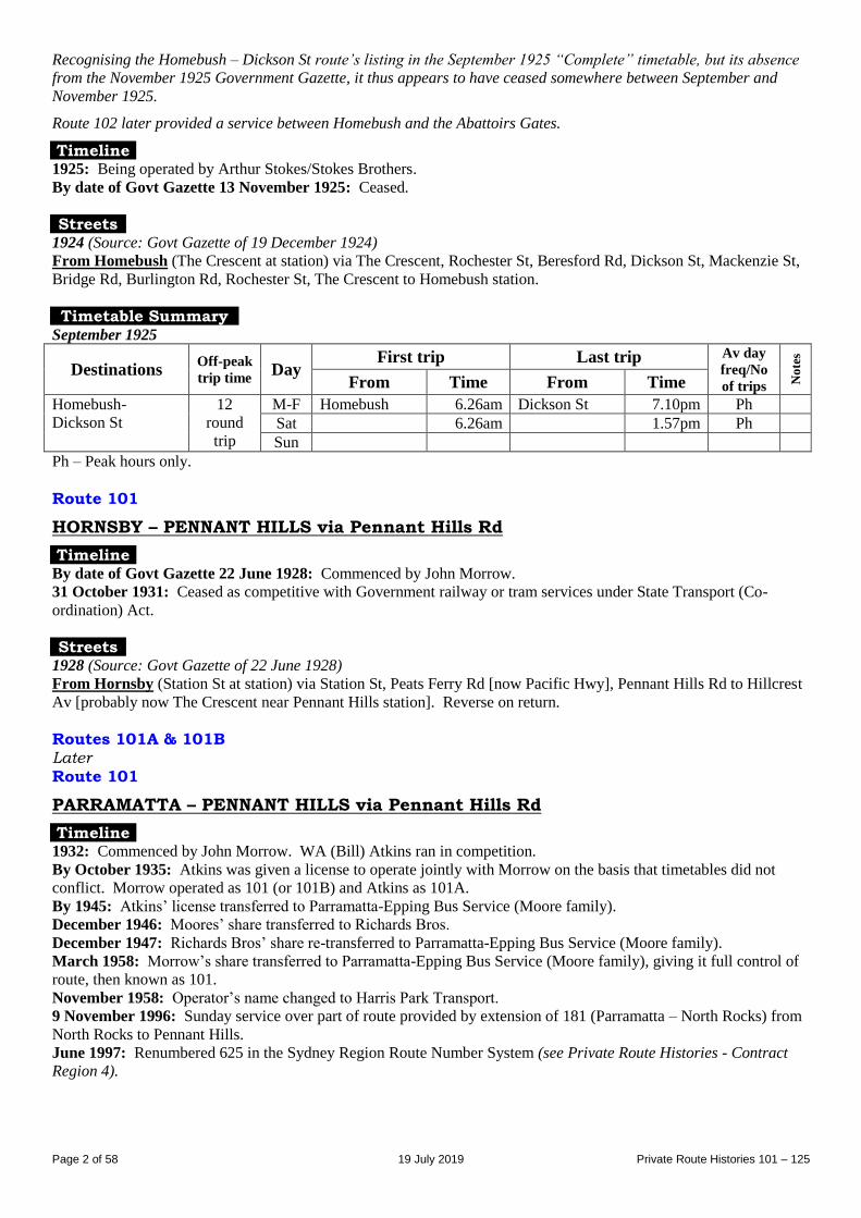
Timetable Summary September 1925
Destinations Off-peak
trip time Day
First trip Last trip Av day
freq/No
of trips No
tes
From Time From Time
Homebush-State
Abattoirs
15 M-F Homebush 10.50am Abattoirs 4.30pm 60 Sat Sun
Route 101
HOMEBUSH – DICKSON ST & BERESFORD RD [in current Strathfield]
General note: Unlike other routes listed as being in operation in 1925, this route is not listed in the Government
Gazette of 13 November 1925. However, it was in operation during 1925, as evidenced by its appearance in (1) the
Doran Report and (2) the“Complete Timetable of Metropolitan Motor Bus Services” dated September 1925.
It and its associated route, Homebush – State Abattoirs (see above), were, however, both listed in the the Government
Gazette of 19 December 1924 as Route 84. They were both operated by A Stokes. The State Abattoirs route was
renumbered 101 in the 1925 Government Gazette. So, if the Dickson St route had survived until November 1925, it is
likely it would also have been renumbered 101.
Page 2 of 58 19 July 2019 Private Route Histories 101 – 125
Recognising the Homebush – Dickson St route’s listing in the September 1925 “Complete” timetable, but its absence
from the November 1925 Government Gazette, it thus appears to have ceased somewhere between September and
November 1925.
Route 102 later provided a service between Homebush and the Abattoirs Gates.
Timeline 1925: Being operated by Arthur Stokes/Stokes Brothers.
By date of Govt Gazette 13 November 1925: Ceased.
Streets 1924 (Source: Govt Gazette of 19 December 1924) From Homebush (The Crescent at station) via The Crescent, Rochester St, Beresford Rd, Dickson St, Mackenzie St,
Bridge Rd, Burlington Rd, Rochester St, The Crescent to Homebush station.
Timetable Summary September 1925
Destinations Off-peak
trip time Day First trip Last trip Av day
freq/No
of trips No
tes
From Time From Time
Homebush-
Dickson St
12
round
trip
M-F Homebush 6.26am Dickson St 7.10pm Ph
Sat 6.26am 1.57pm Ph
Sun
Ph – Peak hours only.
Route 101
HORNSBY – PENNANT HILLS via Pennant Hills Rd
Timeline By date of Govt Gazette 22 June 1928: Commenced by John Morrow.
31 October 1931: Ceased as competitive with Government railway or tram services under State Transport (Co-
ordination) Act.
Streets 1928 (Source: Govt Gazette of 22 June 1928) From Hornsby (Station St at station) via Station St, Peats Ferry Rd [now Pacific Hwy], Pennant Hills Rd to Hillcrest
Av [probably now The Crescent near Pennant Hills station]. Reverse on return.
Routes 101A & 101B Later Route 101
PARRAMATTA – PENNANT HILLS via Pennant Hills Rd
Timeline 1932: Commenced by John Morrow. WA (Bill) Atkins ran in competition.
By October 1935: Atkins was given a license to operate jointly with Morrow on the basis that timetables did not
conflict. Morrow operated as 101 (or 101B) and Atkins as 101A.
By 1945: Atkins’ license transferred to Parramatta-Epping Bus Service (Moore family).
December 1946: Moores’ share transferred to Richards Bros.
December 1947: Richards Bros’ share re-transferred to Parramatta-Epping Bus Service (Moore family).
March 1958: Morrow’s share transferred to Parramatta-Epping Bus Service (Moore family), giving it full control of
route, then known as 101.
November 1958: Operator’s name changed to Harris Park Transport.
9 November 1996: Sunday service over part of route provided by extension of 181 (Parramatta – North Rocks) from
North Rocks to Pennant Hills.
June 1997: Renumbered 625 in the Sydney Region Route Number System (see Private Route Histories - Contract
Region 4).
Page 3 of 58 19 July 2019 Private Route Histories 101 – 125
Streets Circa 1946 (Source: Gregory’s Street Directory)
From Parramatta [station] via Argyle St, Church St, Pennant Hills Rd (Carlingford), Yarrara St [now Rd] (Pennant
Hills).
1963 (Source: RGH notes)
From Parramatta (Argyle St at station) via Valentine Av, Parkes St, Station St, Darcy St, Church St, Pennant Hills
Rd (Carlingford), Yarrara Rd to Pennant Hills station.
From Pennant Hills (Yarrara Rd at station) via Pennant Hills Rd, Church St, Argyle St to Parramatta station.
Prindle St diversion: Ex Parramatta from Pennant Hills Rd via Gollan Av, Gowen Brae Av, Prindle St, Charles St,
Bettington Rd to Pennant Hills Rd. Reverse on return.
Tintern Av diversion: Ex Parramatta from Pennant Hills Rd via Tintern Av, Robert St, Adderton Rd to Pennant
Hills Rd. Reverse on return.
Baker St diversion: Ex Parramatta from Pennant Hills Rd via Baker St, Jenkins Rd, Post Office Rd to Pennant Hills
Rd. Reverse on return.
Alterations
From 15 September 1985 (date of opening of Church St mall)
To approach Parramatta from Church St via George St, Smith St to Parramatta interchange. From Parramatta
(interchange, Station St) via Darcy St, Church St, Argyle St, Marsden St, George St, Church St.
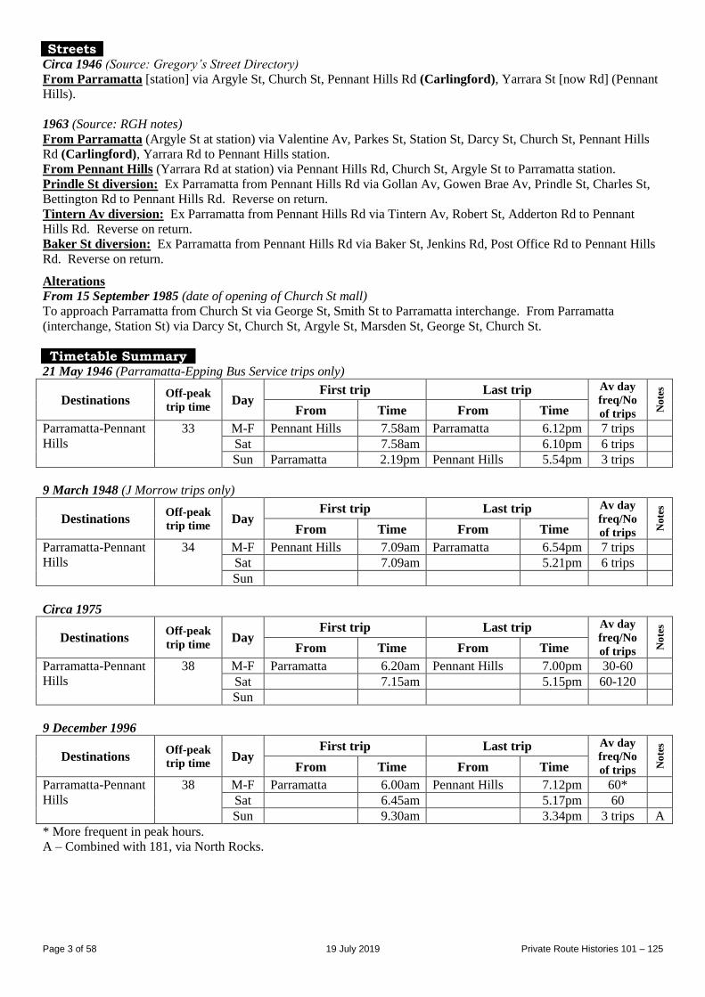
Timetable Summary 21 May 1946 (Parramatta-Epping Bus Service trips only)
Destinations Off-peak
trip time Day
First trip Last trip Av day
freq/No
of trips No
tes
From Time From Time
Parramatta-Pennant
Hills
33 M-F Pennant Hills 7.58am Parramatta 6.12pm 7 trips
Sat 7.58am 6.10pm 6 trips
Sun Parramatta 2.19pm Pennant Hills 5.54pm 3 trips
9 March 1948 (J Morrow trips only)
Destinations Off-peak
trip time Day
First trip Last trip Av day
freq/No
of trips No
tes
From Time From Time
Parramatta-Pennant
Hills
34 M-F Pennant Hills 7.09am Parramatta 6.54pm 7 trips
Sat 7.09am 5.21pm 6 trips
Sun
Circa 1975
Destinations Off-peak
trip time Day
First trip Last trip Av day
freq/No
of trips No
tes
From Time From Time
Parramatta-Pennant
Hills
38 M-F Parramatta 6.20am Pennant Hills 7.00pm 30-60
Sat 7.15am 5.15pm 60-120
Sun
9 December 1996
Destinations Off-peak
trip time Day
First trip Last trip Av day
freq/No
of trips No
tes
From Time From Time
Parramatta-Pennant
Hills
38 M-F Parramatta 6.00am Pennant Hills 7.12pm 60*
Sat 6.45am 5.17pm 60
Sun 9.30am 3.34pm 3 trips A
* More frequent in peak hours.
A – Combined with 181, via North Rocks.
Page 4 of 58 19 July 2019 Private Route Histories 101 – 125
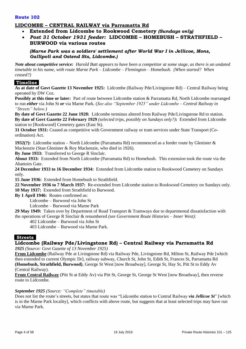
Route 102
LIDCOMBE – CENTRAL RAILWAY via Parramatta Rd Extended from Lidcombe to Rookwood Cemetery (Sundays only)
Post 31 October 1931 feeder: LIDCOMBE – HOMEBUSH – STRATHFIELD –
BURWOOD via various routes
(Marne Park was a soldiers' settlement after World War I in Jellicoe, Mons,
Gallipoli and Ostend Sts, Lidcombe.)
Note about competitive service: Harold Batt appears to have been a competitor at some stage, as there is an undated
timetable in his name, with route Marne Park – Lidcombe – Flemington – Homebush. (When started? When
ceased?)
Timeline As at date of Govt Gazette 13 November 1925: Lidcombe (Railway Pde/Livingstone Rd) – Central Railway being
operated by DW Coz.
Possibly at this time or later: Part of route between Lidcombe station & Parramatta Rd, North Lidcombe rearranged
to run either via John St or via Marne Park. (See also “September 1925” under Lidcombe – Central Railway in
“Streets” below.)
By date of Govt Gazette 22 June 1928: Lidcombe terminus altered from Railway Pde/Livingstone Rd to station.
By date of Govt Gazette 22 February 1929 (selected trips, possibly on Sundays only?): Extended from Lidcombe
station to [Rookwood] Cemetery gates (East St).
31 October 1931: Ceased as competitive with Government railway or tram services under State Transport (Co-
ordination) Act.
1932(?): Lidcombe station – North Lidcombe (Parramatta Rd) recommenced as a feeder route by Glenister &
Mackenzie (Stan Glenister & Roy Mackenzie, who died in 1926).
By June 1933: Transferred to George R Sinclair.
About 1933: Extended from North Lidcombe (Parramatta Rd) to Homebush. This extension took the route via the
Abattoirs Gate.
24 December 1933 to 16 December 1934: Extended from Lidcombe station to Rookwood Cemetery on Sundays
only.
15 June 1936: Extended from Homebush to Strathfield.
22 November 1936 to 7 March 1937: Re-extended from Lidcombe station to Rookwood Cemetery on Sundays only.
10 May 1937: Extended from Strathfield to Burwood.
By 1 April 1946: Routes confirmed as:
Lidcombe – Burwood via John St
Lidcombe – Burwood via Marne Park
29 May 1949: Taken over by Department of Road Transport & Tramways due to departmental dissatisfaction with
the operations of George R Sinclair & renumbered (see Government Route Histories – Inner West):
402 Lidcombe – Burwood via John St
403 Lidcombe – Burwood via Marne Park.
Streets
Lidcombe (Railway Pde/Livingstone Rd) – Central Railway via Parramatta Rd 1925 (Source: Govt Gazette of 13 November 1925)
From Lidcombe (Railway Pde at Livingstone Rd) via Railway Pde, Livingstone Rd, Milton St, Railway Pde [which
then extended to current Olympic Dr], railway subway, Church St, John St, Edith St, Frances St, Parramatta Rd
(Homebush, Strathfield, Burwood), George St West [now Broadway], George St, Hay St, Pitt St to Eddy Av
(Central Railway).
From Central Railway (Pitt St at Eddy Av) via Pitt St, George St, George St West [now Broadway], then reverse
route to Lidcombe.
September 1925 (Source: “Complete” timetable)
Does not list the route’s streets, but states that route was “Lidcombe station to Central Railway via Jellicoe St” [which
is in the Marne Park locality], which conflicts with above route, but suggests that at least selected trips may have run
via Marne Park.
Page 5 of 58 19 July 2019 Private Route Histories 101 – 125
Lidcombe (station) – Central Railway via Parramatta Rd Alteration
1928 (Source: Govt Gazette of 22 June 1928): Lidcombe terminus moved to station (John St at Church St).
Lidcombe (station) – Central Railway via Parramatta Rd (possibly selected trips
extended to [Rookwood] Cemetery Gates) Alteration
1929 (Source: Govt Gazette of 22 February 1929): Extended from Lidcombe station (John St) via Church St,
Railway St, East St to [Rookwood] Cemetery gates. Reverse on return.
Lidcombe – Homebush – Strathfield – Burwood Circa 1946 (likely routes based on Gregory’s Street Directory & Department of Road Transport & Tramways
timetable for routes 402 & 403, which replaced 102 in May 1949)
Via John St From Lidcombe (Church St at station) via Church St, John St, Parramatta Rd, Station St, Loftus Cr (Homebush),
Rochester [now Knight] St, Parramatta Rd, Concord Rd [now Swan Av], Cooper St, Moseley St (Strathfield),
Everton Rd, Moseley St, Cooper St, Rowley St, Park Rd, Park Av, Burwood Rd, George St East, Mary St, Deane St
(Burwood station).
From Burwood (Deane St at station) via Burwood Rd, then reverse route to John St, then Mary St, Swete St, Church
St to Lidcombe station.
Via Marne Park From Lidcombe (Church St at station) via Church St, John St, Mary St, Swete St, Rawson St, Platform St, Belgium
St, Jellicoe St, Nicholas St, Mons St, Parramatta Rd, then same route as “via John St” to Burwood station.
From Burwood (Deane St at station) via Burwood Rd, then reverse route to Swete St, then Church St to Lidcombe
station.
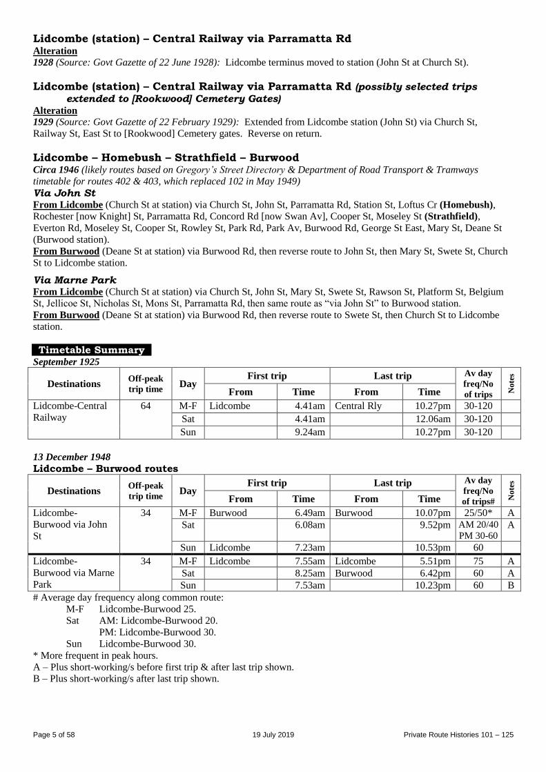
Timetable Summary September 1925
Destinations Off-peak
trip time Day
First trip Last trip Av day
freq/No
of trips No
tes
From Time From Time
Lidcombe-Central
Railway
64 M-F Lidcombe 4.41am Central Rly 10.27pm 30-120 Sat 4.41am 12.06am 30-120 Sun 9.24am 10.27pm 30-120
13 December 1948
Lidcombe – Burwood routes
Destinations Off-peak
trip time Day
First trip Last trip Av day
freq/No
of trips# No
tes
From Time From Time
Lidcombe-
Burwood via John
St
34 M-F Burwood 6.49am Burwood 10.07pm 25/50* A
Sat 6.08am 9.52pm AM 20/40
PM 30-60 A
Sun Lidcombe 7.23am 10.53pm 60
Lidcombe-
Burwood via Marne
Park
34 M-F Lidcombe 7.55am Lidcombe 5.51pm 75 A
Sat 8.25am Burwood 6.42pm 60 A
Sun 7.53am 10.23pm 60 B
# Average day frequency along common route:
M-F Lidcombe-Burwood 25.
Sat AM: Lidcombe-Burwood 20.
PM: Lidcombe-Burwood 30.
Sun Lidcombe-Burwood 30.
* More frequent in peak hours.
A – Plus short-working/s before first trip & after last trip shown.
B – Plus short-working/s after last trip shown.
Page 6 of 58 19 July 2019 Private Route Histories 101 – 125
Route 102
INGLEBURN – INGLEBURN TOWNSHIP MACQUARIE FIELDS – HOUSING COMMISSION AREA (Eucalyptus Dr) MACQUARIE FIELDS – INGLEBURN – CAMPBELLTOWN
MINTO – EAGLE HEIGHTS MINTO – MINTO HOUSING ESTATE (Mortimer St & Pendergast Av areas)
MINTO – ST ANDREWS
(Eagle Heights is now known as Raby.)
(The Point is now known as Long Point.)
Timeline February 1953: Macquarie Fields – Ingleburn – Campbelltown via The Point (Wills Rd/Kingdon Pde) renumbered
from part of 92, operated by Herbert P Harrison.
1 September 1961: Transferred to Oliveri Bros (later Oliveri Transport Services).
By June 1970: Transferred to one branch of the Oliveri family & operator’s name changed to Ingleburn Bus Service.
By 21 July 1975: New route, Macquarie Fields – Housing Commission area (Eucalyptus Dr), commenced.
By 7 July 1980:
Macquarie Fields – Campbelltown extended from Campbelltown to Macarthur Square (Macarthur Square
shops opened on 10 September 1979).
New routes commenced:
Ingleburn – Ingleburn Township
Minto – Minto Housing Estate (Mortimer St & Pendergast Av areas)
Minto – St Andrews Estate (new suburb).
By 1 December 1980: New route, Minto – Eagle Heights (new suburb), commenced.
26 June 1983: Sunday-only service commenced & given numbers in the Sydney Region Route Number System (see
Private Route Histories - Contract Region 2):
871 Macquarie Fields – Eucalyptus Dr via Saywell Rd
872 Macquarie Fields – Eucalyptus Dr via Parliament Rd
4 December 1983: Entire route reorganized and renumbered into Sydney Region Route Number System (see Private
Route Histories - Contract Region 2):
870 Macquarie Fields – Macarthur Square
871 Macquarie Fields – Eucalyptus Dr via Saywell Rd
872 Macquarie Fields – Eucalyptus Dr via Parliament Rd
873 Ingleburn – Minto via Lagonda Dr & Mortimer St
874 Minto – St Andrews – Raby.
Streets
Macquarie Fields – Ingleburn – Campbelltown Circa 1962 (Source: Collins Street Directory)
From Macquarie Fields (station) via Railway Pde, Saywell Rd, [intermediate details not on maps], Bensley Rd,
Oxford St [now Rd] to Ingleburn station, then Oxford St [now Rd], Cumberland Rd, Minto Rd (Minto), Redfern Rd,
Pembroke Rd, [Old] Leumeah Rd, O’Sullivan Rd (Leumeah), Rudd Rd [part now Beverley Rd], Chamberlain St,
Queen St (Campbelltown).
1970 (Source: RGH notes)
From Macquarie Fields (Railway Pde at station) via Saywell Rd [including current Groundsel Av, Astelia St], Wills
Rd to Kingdon Pde (The Point), then Wills Rd [including current Linum St], Oakley Rd, Bensley Rd, Oxford Rd,
Nardoo St, Norfolk St, Ingleburn Rd (Ingleburn), Oxford Rd, Carlisle St, Chester St, Brenda St, Sackville St,
Cumberland Rd, Minto Rd (Minto), Redfern Rd, Pembroke Rd, [Old] Leumeah Rd, O’Sullivan Rd (Leumeah), Rudd
Rd [part now Beverley Rd], Chamberlain St, Queen St, Dumaresq St, Oxley St [now Moore-Oxley Bypass], Allman
St, Queen St to Campbelltown Post Office.
From Campbelltown (Queen St at Post Office) via Queen St, Chamberlain St, then reverse route to Carlisle St, then
Nardoo St, Norfolk St, Ingleburn Rd (Ingleburn), Oxford Rd, Bensley Rd, then reverse route to Macquarie Fields
station.
Trips via Macquarie Rd: Ex Macquarie Fields from Saywell Rd via Fields Rd, Macquarie Rd, Cumberland Rd to
Oxford Rd. Reverse on return.
Kingsclare St diversion: Ex Macquarie Fields from O’Sullivan Rd via Kingsclare St to Rudd Rd. Reverse on return.
Page 7 of 58 19 July 2019 Private Route Histories 101 – 125
Macquarie Fields – Housing Commission Area (Eucalyptus Dr) Circa 1980 (Source: Public Transport Map of Sydney & suburbs)
From Macquarie Fields (Railway Pde at station) via Saywell Rd, Parliament Rd, Rosewood Dr, Eucalyptus Dr
(Housing Commission Area), Rosewood Dr, Parliament Rd, Saywell Rd to Macquarie Fields station.
Ingleburn – Ingleburn Township Circa 1980 (Source: Public Transport Map of Sydney & suburbs)
From Ingleburn (station) via Oxford Rd, Bensley Rd, Chester Rd [part now Mercedes Rd], Collins Prom, Oxford Rd
to Ingleburn station.
Minto – Eagle Heights [now Raby] 1 December 1980 (Source: timetable)
From Minto (western side of station) via Redfern Rd, Campbelltown Rd, Raby Rd, Spitfire Dr, Hurricane Dr (Eagle
Heights), Mustang Dr, Raby Rd, then return to Minto station.
Macquarie Fields – Ingleburn via Eucalyptus Dr (Sundays only) From 30 June 1982 (Source: timetable)
From Macquarie Fields (Railway Pde at station) via Saywell Rd, Parliament Rd, Harold St, Rosewood Dr,
Eucalyptus Dr, Evelyn St, Saywell Rd [including current Groundsel Av, Astelia St], Fields Rd, Collins Prom, Chester
Rd, Cumberland Rd, Sackville St, Brenda St, Chester Rd, Ingleburn Rd to Ingleburn station.
From Ingleburn (Ingleburn Rd at station) via Oxford Rd, Carlisle St, Chester St, Brenda St, then reverse route to
Macquarie Fields station.
Timetable Summary 16 September 1963
Destinations Off-peak
trip time Day
First trip Last trip Av day
freq/No
of trips No
tes
From Time From Time
Macquarie Fields-
Ingleburn-
Campbelltown
Fr M Flds
Cm27
Cp48
M-F Macquarie Fds 8.28am Campbelltown 5.40pm A
Sat 8.00am 12.20pm 4 trips B
Sun
A – 7 trips from Macquarie Fields to Campbelltown, 10 trips from Campbelltown to Macquarie Fields. Plus peak
hour short-workings Ingleburn-Ingleburn (Brenda St) & Macquarie Fields-Ingleburn (Bensley Rd/Kings Rd).
Trips routed via The Point: morning, mainly trips to Macquarie Fields, afternoon mainly trips from Macquarie
Fields (other trips ran via Macquarie Rd).
B – All Saturday trips via The Point. Plus short-working/s before first trip & after last trip shown. Plus picture bus to
Campbelltown Saturday night.
Cm – To Campbelltown direct via Macquarie Rd.
Cp – To Campbelltown via The Point.
21 July 1975
Destinations Off-peak
trip time Day
First trip Last trip Av day
freq/No
of trips No
tes
From Time From Time
Macquarie Fields-
Ingleburn-
Campbelltown
31 M-F Macquarie Fds 6.55am Campbelltown 5.35pm 60
Sat 8.40am 12.20pm 60
Sun
Macquarie Fields-
Housing
Commission Area
20
round
trip
M-F Macquarie Fds 5.36am Macquarie Fds 6.37pm 60*
Sat 7.09am 1.00pm 30
Sun
Also limited service Ingleburn-Macquarie Fields via The Point.
* More frequent in peak hours.
Page 8 of 58 19 July 2019 Private Route Histories 101 – 125
7 July 1980
Destinations Off-peak
trip time Day
First trip Last trip Av day
freq/No
of trips No
tes
From Time From Time
Macquarie Fields-
Campbelltown
51 M-F Macquarie Flds 6.20am Macarthur Sq 5.40pm 35
Sat 7.44am 12.40pm 45
Sun
Macquarie Fields-
Eucalyptus Dr
20
round
trip
M-F Macquarie Flds 5.21am Eucalyptus Dr 7.26pm 30*
Sat 7.05am 1.19pm 30
Sun
Minto-Minto
Housing Estate
17
round
trip
M-F Minto 5.36am Minto 7.09pm 30*
Sat 7.21am 1.11pm 30
Sun
Minto-St Andrews 16
round
trip
M-F Minto 5.55am Minto 6.36pm 120*
Sat 9.12am 12.12pm 2 trips
Sun
Ingleburn-
Ingleburn
Township
12
round
trip
M-F Ingleburn 5.44am Ingleburn 6.51pm 30*
Sat
Sun
* More frequent in peak hours.
Route 103
HURLSTONE PARK – CENTRAL RAILWAY via Denison St & Parramatta Rd
Timeline As at date of Govt Gazette 13 November 1925: In operation.
By date of Govt Gazette 15 October 1926: Ceased.
Timetable Summary September 1925
Destinations Off-peak
trip time Day
First trip Last trip Av day
freq/No
of trips No
tes
From Time From Time
Hurlstone Park-
Central Railway
35 M-F Hurlstone Pk 6.38am Central Rly 7.56pm 30-60 A
Sat 6.38am 11.28pm 30-60
Sun 7.52am 10.06pm 80
A – Extra trips Friday night.
Route 103
HORNSBY – GALSTON – BIRRALEE via Galston Gorge HORNSBY – HORNSBY (Somerville Rd) via various routes
HORNSBY – HORNSBY NORTH Extended from Birralee to Berowra Creek (selected trips, 1935-1950s?)
(“Birralee” has also been spelt “Birrilee”. Current spelling is “Berrilee”.)
(Somerville Rd, Hornsby terminus is in current Hornsby Heights.)
Timeline By date of Govt Gazette 22 June 1928: Hornsby – Galston – Arcadia commenced by Jack Scott.
By October 1935: Transferred to F Black.
5 October 1935: Extended from Arcadia to Berowra Creek via Birralee.
April 1943: Transferred to Berowra Coach Services (Roy H Corrigan).
After 1948: Extra route, Hornsby – Hornsby (Somerville Rd), commenced.
Page 9 of 58 19 July 2019 Private Route Histories 101 – 125
By 1 August 1955:
Hornsby – Hornsby (Somerville Rd) ran via various combinations of route, including short-workings. Typical
trips were:
Hornsby – Hornsby (Somerville Rd) direct via Galston Rd
Hornsby – Hornsby (Somerville Rd) via Lodge St
Hornsby – Hornsby (loop via Lodge St & Rosamond St).
Service between Birralee & Berowra Creek ceased or became a school-only route.
By 9 April 1963: Following the opening of new streets in Asquith, most “via Lodge St” trips rerouted via Asquith.
23 November 1970: Additional weekday off-peak route commenced on trial, Hornsby – Hornsby North (loop), via
Bouvardia St, Hazelmead Rd West [former street] & Mittabah Rd.
By November 1973: Hornsby – Hornsby (Somerville Rd) & short-workings thereof & Hornsby – Hornsby North
(loop) reorganised into two standard routes:
Hornsby – Hornsby Heights (Somerville Rd) via Galston Rd direct
Hornsby – Hornsby North (via a revised loop, anti-clockwise in morning and clockwise in afternoon)
(originally weekday daytime, but also Saturday mornings by October 1974).
1 July 1974: Berowra Coach Services transferred to Jim Knox (becoming part of the Hornsby Bus Group).
12 August 1974: Hornsby – Birralee replaced by new 203 Pennant Hills – Birralee, operated by Glenorie Bus Co.
28 September 1987: As part of general reorganization of Hornsby Bus Group’s routes, renumbered into the Sydney
Region Route Number System (see Private Route Histories - Contract Region 12):
596 Hornsby – Hornsby Heights
Hornsby – Hornsby North became part of 595 (Hornsby – Mt Colah loops).
Streets
Hornsby – Arcadia 1928 (Source: Govt Gazette of 22 June 1928) From Hornsby (Railway premises near parcels office) via Station St, Coronation St, Peats Ferry Rd [now Pacific
Hwy], Galston Rd (Galston), Arcadia Rd to Arcadia Post Office. Reverse on return.
Hornsby – Birralee – Berowra Waters Circa 1946 (Source: Gregory’s Street Directory)
From Hornsby [station] via Station St, Coronation St, Pacific Hwy, Galston Rd (Galston), Arcadia Rd (Arcadia),
Berowra Creek [now Bay] Rd (Birralee) to Berowra Waters.
Hornsby – Birralee 1963 (Source: RGH notes)
From Hornsby (Station St at station) via Station St, Coronation St, Pacific Hwy, Galston Rd (Galston), Arcadia Rd
(Arcadia), Bay Rd to Chilcott Rd (Birralee).
From Birralee (Bay Rd at Chilcott Rd) via reverse route to Pacific Hwy, then Station St to Hornsby station.
Hornsby – Hornsby (Somerville Rd) & short-workings 1955 (likely routes based on 1 August 1955 timetable &1963 RGH notes)
Hornsby – Hornsby (Somerville Rd) via Lodge St From Hornsby (Station St at station) via Jersey St, Citrus Av, Pacific Hwy, Lodge St, Amor St, Old Berowra Rd,
Ethel St, Galston Rd, Somerville Rd (Hornsby).
From Hornsby (Somerville Rd) via reverse route to Jersey St, then Coronation St, Pacific Hwy, Station St to Hornsby
station.
Hornsby – Hornsby (Somerville Rd) direct via Galston Rd From Hornsby (Station St at station) via Coronation St, Pacific Hwy, Galston Rd, Somerville Rd (Hornsby).
From Hornsby (Somerville Rd) via reverse route to Pacific Hwy, then Station St to Hornsby station.
Hornsby – Hornsby (loop via Lodge St & Rosamond St) From Hornsby (Station St at station) via Jersey St, Citrus Av, Pacific Hwy, Lodge St, Amor St, Old Berowra Rd,
Ethel St, Rosamond St,Carrington St, Pacific Hwy, Station St to Hornsby station. Some trips: Reverse route.
1963 (Source: RGH notes)
Hornsby – Hornsby (Somerville Rd) via Asquith From Hornsby (Station St at station) via Jersey St, Pacific Hwy (Asquith), Amor St, Old Berowra Rd, Ethel St,
Galston Rd, Somerville Rd (Hornsby).
Page 10 of 58 19 July 2019 Private Route Histories 101 – 125
From Hornsby (Somerville Rd) via reverse route to Jersey St, then Coronation St, Pacific Hwy, Station St to Hornsby
station.
Hornsby – Hornsby (loop via Asquith & Rosamond St) From Hornsby (Station St at station) via Jersey St, Pacific Hwy (Asquith), Amor St, Old Berowra Rd, Ethel St,
Rosamond St, Carrington St, Pacific Hwy, Station St to Hornsby station. Some trips: Reverse route.
Alteration
By 1964: Ex Hornsby from Ethel St via Alan Av, Clarinda St, Rosamond St. Reverse on return.
Hornsby – Hornsby Heights By November 1973 (Source: based on 1986 RGH notes)
From Hornsby (Station St at station) via Coronation St, Pacific Hwy, Galston Rd, Somerville Rd to Binya Cl
(Hornsby Heights).
From Hornsby Heights (Somerville Rd at Binya Cl) via reverse route to Pacific Hwy, then Station St to Hornsby
station.
Brett Av diversion (morning ex Hornsby Heights, afternoon ex Hornsby): From Galston Rd/Somerville Rd via
Galston Rd, Brett Av, Ulolo Av (clockwise loop), Brett Av, Galston Rd to Somerville Rd.
Hornsby – Hornsby North Loop By October 1974
Mornings From Hornsby (Station St at station) via Jersey St, Mildred Av, Citrus St, Pacific Hwy, Lodge St, Amor St,
Bouvardia St, Mittabah Rd (Hornsby North), Old Berowra Rd, Ethel St, Alan Av, Clarinda St, Rosamond St,
Carrington Rd, Galston Rd, Pacific Hwy, Station St to Hornsby station.
Afternoons From Hornsby (Station St at station) via Coronation St, Pacific Hwy, Galston Rd, then reverse of morning route to
Jersey St, then Coronation St, Pacific Hwy, Station St to Hornsby station.
Alteration
By September 1982: From Hornsby via Coronation St, Pacific Hwy, Lodge St. Return from Lodge St via Pacific
Hwy, Station St.
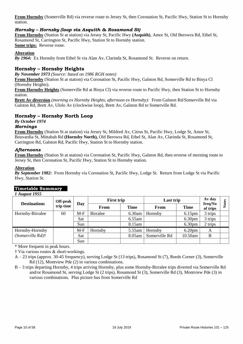
Timetable Summary 1 August 1955
Destinations Off-peak
trip time Day
First trip Last trip Av day
freq/No
of trips No
tes
From Time From Time
Hornsby-Birralee 60 M-F Birralee 6.30am Hornsby 6.15pm 3 trips
Sat 6.55am 6.30pm 3 trips
Sun 8.15am 6.30pm 2 trips
Hornsby-Hornsby
(Somerville Rd)†
M-F Hornsby 5.55am Hornsby 6.20pm A
Sat 8.05am Somerville Rd 10.50am B
Sun
* More frequent in peak hours.
† Via various routes & short-workings.
A – 23 trips (approx. 30-45 frequency), serving Lodge St (13 trips), Rosamond St (7), Reeds Corner (3), Somerville
Rd (12), Montview Pde (2) in various combinations.
B – 3 trips departing Hornsby, 4 trips arriving Hornsby, plus some Hornsby-Birralee trips diverted via Somerville Rd
and/or Rosamond St, serving Lodge St (2 trips), Rosamond St (3), Somerville Rd (3), Montview Pde (3) in
various combinations. Plus picture bus from Somerville Rd
Page 11 of 58 19 July 2019 Private Route Histories 101 – 125
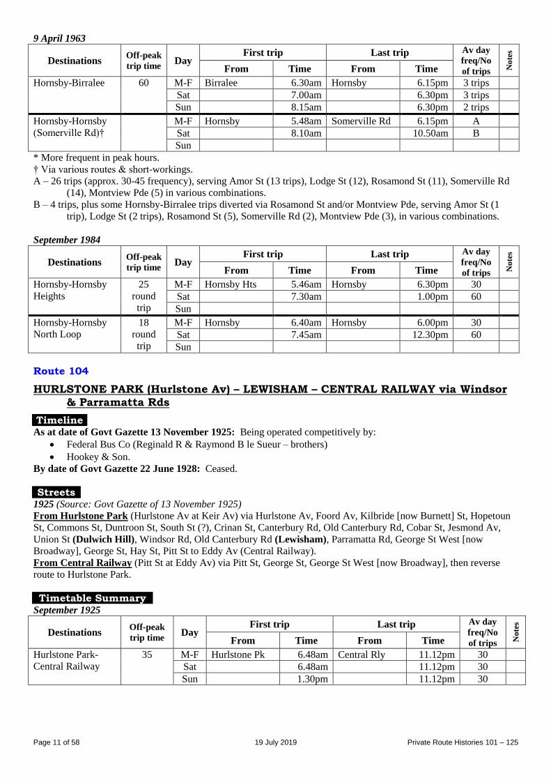
9 April 1963
Destinations Off-peak
trip time Day
First trip Last trip Av day
freq/No
of trips No
tes
From Time From Time
Hornsby-Birralee 60 M-F Birralee 6.30am Hornsby 6.15pm 3 trips
Sat 7.00am 6.30pm 3 trips
Sun 8.15am 6.30pm 2 trips
Hornsby-Hornsby
(Somerville Rd)†
M-F Hornsby 5.48am Somerville Rd 6.15pm A
Sat 8.10am 10.50am B
Sun
* More frequent in peak hours.
† Via various routes & short-workings.
A – 26 trips (approx. 30-45 frequency), serving Amor St (13 trips), Lodge St (12), Rosamond St (11), Somerville Rd
(14), Montview Pde (5) in various combinations.
B – 4 trips, plus some Hornsby-Birralee trips diverted via Rosamond St and/or Montview Pde, serving Amor St (1
trip), Lodge St (2 trips), Rosamond St (5), Somerville Rd (2), Montview Pde (3), in various combinations.
September 1984
Destinations Off-peak
trip time Day
First trip Last trip Av day
freq/No
of trips No
tes
From Time From Time
Hornsby-Hornsby
Heights
25
round
trip
M-F Hornsby Hts 5.46am Hornsby 6.30pm 30
Sat 7.30am 1.00pm 60
Sun
Hornsby-Hornsby
North Loop
18
round
trip
M-F Hornsby 6.40am Hornsby 6.00pm 30
Sat 7.45am 12.30pm 60
Sun
Route 104
HURLSTONE PARK (Hurlstone Av) – LEWISHAM – CENTRAL RAILWAY via Windsor
& Parramatta Rds
Timeline As at date of Govt Gazette 13 November 1925: Being operated competitively by:
Federal Bus Co (Reginald R & Raymond B le Sueur – brothers)
Hookey & Son.
By date of Govt Gazette 22 June 1928: Ceased.
Streets 1925 (Source: Govt Gazette of 13 November 1925)
From Hurlstone Park (Hurlstone Av at Keir Av) via Hurlstone Av, Foord Av, Kilbride [now Burnett] St, Hopetoun
St, Commons St, Duntroon St, South St (?), Crinan St, Canterbury Rd, Old Canterbury Rd, Cobar St, Jesmond Av,
Union St (Dulwich Hill), Windsor Rd, Old Canterbury Rd (Lewisham), Parramatta Rd, George St West [now
Broadway], George St, Hay St, Pitt St to Eddy Av (Central Railway).
From Central Railway (Pitt St at Eddy Av) via Pitt St, George St, George St West [now Broadway], then reverse
route to Hurlstone Park.
Timetable Summary September 1925
Destinations Off-peak
trip time Day
First trip Last trip Av day
freq/No
of trips No
tes
From Time From Time
Hurlstone Park-
Central Railway
35 M-F Hurlstone Pk 6.48am Central Rly 11.12pm 30
Sat 6.48am 11.12pm 30
Sun 1.30pm 11.12pm 30
Page 12 of 58 19 July 2019 Private Route Histories 101 – 125
Route 104
GLADESVILLE – TENNYSON POINT – PUTNEY POINT – RYDE
Timeline By date of Govt Gazette 22 February 1929: Commenced by Sidney Armitage & Frederick J Waller.
By 1931: Absorbed into 152.
Streets 1929 (Source: Govt Gazette of 22 February 1929) From Gladesville (Meriton St at memorial [at Great North Rd, now Victoria Rd]) via Meriton St, Morrison Rd,
Tennyson Rd (Tennyson Point), Champion Rd, Morrison Rd, Charles St, [Delange Rd ?], Pellisier Rd to Putney
Point, then Pellisier Rd, [Delange Rd ?], Charles St, Great North [now Victoria] Rd to Pope St (Ryde). Reverse on
return.
Route 104
HORNSBY – EAST HORNSBY (Palmerston Rd)
Extended from East Hornsby to Normanhurst (1933)
Timeline 24 August 1932: Hornsby – East Hornsby (Palmerston Rd) [at or near Hornsby Hospital] commenced by AA (Alex)
Newson.
26 August 1933: Extended from East Hornsby (Palmerston Rd) to Normanhurst.
20 October 1933: Extension from East Hornsby (Palmerston Rd) to Normanhurst ceased.
By 1946(?): Ceased. Replaced by existing 107 Hornsby – Hornsby Hospital. (Did 104 & 107 run to Hornsby
Hospital simultaneously?)
Streets
From 26 August 1933 (Source: Sydney Morning Herald, 12 August 1933)
Normanhurst extension: From East Hornsby (Palmerston Rd) via Myra St, Ingram Rd, [Pacific Hwy,] Pennant Hills
Rd, Normanhurst Rd, Denman Pde to Normanhurst station.
Route 104
HORNSBY – ASQUITH GOLF LINKS – MT COLAH (Bolton Av) HORNSBY – HORNSBY (Pretoria Pde)
Timeline 1946: New routes commenced by AA (Alex) Newson:
Hornsby – Asquith Golf Links
Hornsby – Hornsby (Pretoria Pde)
August 1959: Transferred to Hornsby District Bus Co (AJ (Jack) Leighton).
18 March 1967: Selected trips on Saturday mornings extended from Asquith Golf Links to Mt Colah (Bolton Av),
providing a service to east side of Mt Colah, as 220 did not operate on Saturdays.
June 1967:
Hornsby District Bus Co transferred to Jim Knox. As Jim Knox acquired other routes from 1968 onwards, the
overall operation became known as the Hornsby Bus Group.
Extended from Asquith Golf Links to Mt Colah (Bolton Av) on weekdays, replacing 220 on east side of Mt
Colah.
By 29 August 1973: Hornsby – Hornsby (Pretoria Pde) replaced by rerouting of 148 via Pretoria Pde, leaving
104 as Hornsby – Asquith Golf Links – Mt Colah (Bolton Av). 28 September 1987: Amalgamated with Parklands Rd part of 55 & renumbered part of 593 in the Sydney Region
Route Number System as part of general reorganization of Hornsby Bus Group’s routes (see Private Route Histories -
Contract Region 12).
Streets
Hornsby – Asquith Golf Links Circa 1946 (Source: Gregory’s Street Directory)
From Hornsby via Station St, Jersey St, Bridge St, Railway Pde, Stephen St, Lessing St, Lockwood St, Olive St,
Winston St, Haldane Av, Royston Pde (Asquith Golf Links).
Page 13 of 58 19 July 2019 Private Route Histories 101 – 125
1963 (Source: RGH notes)
From Hornsby (Station St at station) via Jersey St, Bridge Rd, Railway Pde, Stephen St, Lessing St, Lockwood St,
Sherbrook Rd, Royston Pde to Queens Rd (Asquith Golf Links).
From Asquith Golf Links (Royston Pde at Queens Rd) via reverse route to Jersey St, then Coronation St, Pacific
Hwy, Station St to Hornsby station.
Hornsby – Asquith Golf Links – Mt Colah (Bolton Av) 1967 (Source: RGH notes)
From Hornsby (Station St at station) via Jersey St, Bridge Rd, Railway Pde, Stephen St, Lessing St, Lockwood St,
Sherbrook Rd (Asquith), Royston Pde, Kuring-gai Chase Rd, Bolton Av (Mt Colah), Gray St, Cowan Rd, Belmont
Pde, Royston Pde, then reverse route to Jersey St, then Coronation St, Pacific Hwy, Station St to Hornsby station.
Hornsby – Hornsby (Pretoria Pde) 1963 (Source: RGH notes)
From Hornsby (Station St at station) via Pacific Hwy, Pretoria Pde to Milner St (Hornsby). Reverse on return.
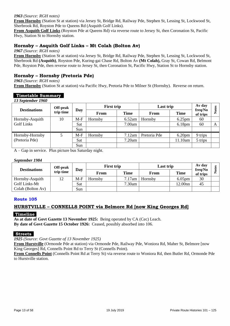
Timetable Summary 13 September 1960
Destinations Off-peak
trip time Day
First trip Last trip Av day
freq/No
of trips No
tes
From Time From Time
Hornsby-Asquith
Golf Links
10 M-F Hornsby 6.52am Hornsby 6.25pm 60
Sat 7.00am 6.18pm 60 A
Sun
Hornsby-Hornsby
(Pretoria Pde)
5 M-F Hornsby 7.12am Pretoria Pde 6.20pm 9 trips
Sat 7.20am 11.10am 5 trips
Sun
A – Gap in service. Plus picture bus Saturday night.
September 1984
Destinations Off-peak
trip time Day
First trip Last trip Av day
freq/No
of trips No
tes
From Time From Time
Hornsby-Asquith
Golf Links-Mt
Colah (Bolton Av)
12 M-F Hornsby 7.17am Hornsby 6.05pm 30
Sat 7.30am 12.00nn 45
Sun
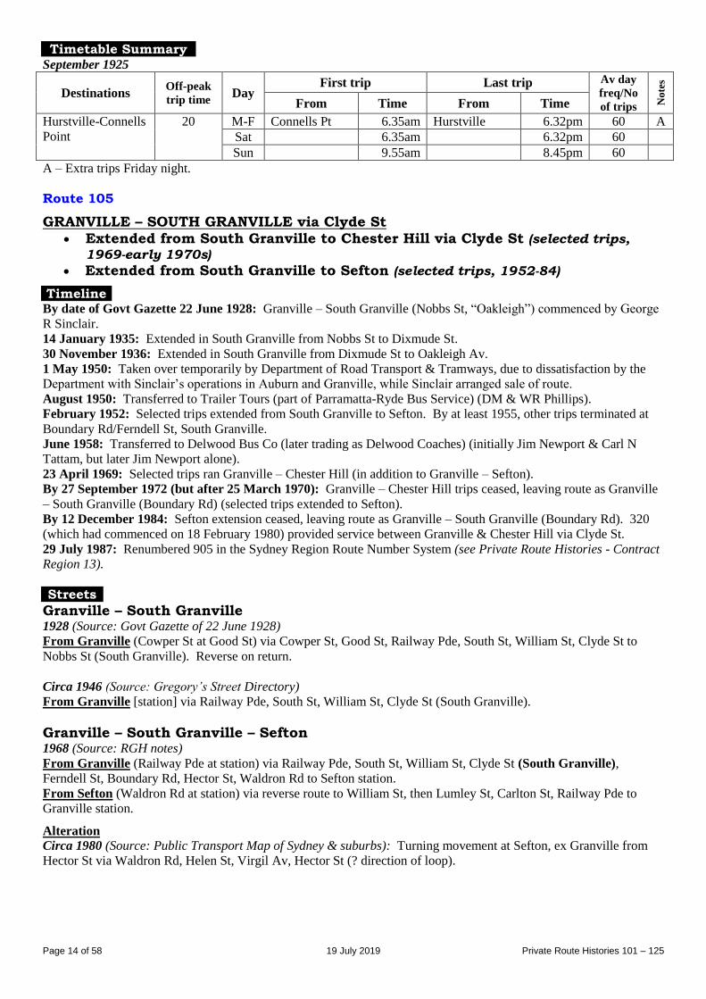
Route 105
HURSTVILLE – CONNELLS POINT via Belmore Rd [now King Georges Rd]
Timeline As at date of Govt Gazette 13 November 1925: Being operated by CA (Cec) Leach.
By date of Govt Gazette 15 October 1926: Ceased, possibly absorbed into 106.
Streets 1925 (Source: Govt Gazette of 13 November 1925)
From Hurstville (Ormonde Pde at station) via Ormonde Pde, Railway Pde, Woniora Rd, Maher St, Belmore [now
King Georges] Rd, Connells Point Rd to Terry St (Connells Point).
From Connells Point (Connells Point Rd at Terry St) via reverse route to Woniora Rd, then Butler Rd, Ormonde Pde
to Hurstville station.
Page 14 of 58 19 July 2019 Private Route Histories 101 – 125
Timetable Summary September 1925
Destinations Off-peak
trip time Day
First trip Last trip Av day
freq/No
of trips No
tes
From Time From Time
Hurstville-Connells
Point
20 M-F Connells Pt 6.35am Hurstville 6.32pm 60 A
Sat 6.35am 6.32pm 60
Sun 9.55am 8.45pm 60
A – Extra trips Friday night.
Route 105
GRANVILLE – SOUTH GRANVILLE via Clyde St Extended from South Granville to Chester Hill via Clyde St (selected trips,
1969-early 1970s)
Extended from South Granville to Sefton (selected trips, 1952-84)
Timeline By date of Govt Gazette 22 June 1928: Granville – South Granville (Nobbs St, “Oakleigh”) commenced by George
R Sinclair.
14 January 1935: Extended in South Granville from Nobbs St to Dixmude St.
30 November 1936: Extended in South Granville from Dixmude St to Oakleigh Av.
1 May 1950: Taken over temporarily by Department of Road Transport & Tramways, due to dissatisfaction by the
Department with Sinclair’s operations in Auburn and Granville, while Sinclair arranged sale of route.
August 1950: Transferred to Trailer Tours (part of Parramatta-Ryde Bus Service) (DM & WR Phillips).
February 1952: Selected trips extended from South Granville to Sefton. By at least 1955, other trips terminated at
Boundary Rd/Ferndell St, South Granville.
June 1958: Transferred to Delwood Bus Co (later trading as Delwood Coaches) (initially Jim Newport & Carl N
Tattam, but later Jim Newport alone).
23 April 1969: Selected trips ran Granville – Chester Hill (in addition to Granville – Sefton).
By 27 September 1972 (but after 25 March 1970): Granville – Chester Hill trips ceased, leaving route as Granville
– South Granville (Boundary Rd) (selected trips extended to Sefton).
By 12 December 1984: Sefton extension ceased, leaving route as Granville – South Granville (Boundary Rd). 320
(which had commenced on 18 February 1980) provided service between Granville & Chester Hill via Clyde St.
29 July 1987: Renumbered 905 in the Sydney Region Route Number System (see Private Route Histories - Contract
Region 13).
Streets
Granville – South Granville 1928 (Source: Govt Gazette of 22 June 1928)
From Granville (Cowper St at Good St) via Cowper St, Good St, Railway Pde, South St, William St, Clyde St to
Nobbs St (South Granville). Reverse on return. Circa 1946 (Source: Gregory’s Street Directory)
From Granville [station] via Railway Pde, South St, William St, Clyde St (South Granville).
Granville – South Granville – Sefton 1968 (Source: RGH notes)
From Granville (Railway Pde at station) via Railway Pde, South St, William St, Clyde St (South Granville),
Ferndell St, Boundary Rd, Hector St, Waldron Rd to Sefton station.
From Sefton (Waldron Rd at station) via reverse route to William St, then Lumley St, Carlton St, Railway Pde to
Granville station.
Alteration
Circa 1980 (Source: Public Transport Map of Sydney & suburbs): Turning movement at Sefton, ex Granville from
Hector St via Waldron Rd, Helen St, Virgil Av, Hector St (? direction of loop).
Page 15 of 58 19 July 2019 Private Route Histories 101 – 125
Timetable Summary 30 October 1944
Destinations Off-peak
trip time Day
First trip Last trip Av day
freq/No
of trips No
tes
From Time From Time
Granville-South
Granville
(Oakleigh Av)
10 M-F Granville 9.17am Oakleigh Av 6.23pm 60
Sat 9.32am 7.00pm 6 trips A
Sun 9.48am 9.58pm 60
A – Plus picture bus Saturday night.
June 1956
Destinations Off-peak
trip time Day
First trip Last trip Av day
freq/No
of trips No
tes
From Time From Time
Granville-South
Granville
(Boundary Rd)†
Fr Gran
16B
21S
M-F Granville 5.34am Boundary Rd 12.00mn 40* A
Sat 7.06am 12.33am AM 15
PM 30
C
Sun 6.51am 11.23pm 40 D
* More frequent in peak hours.
† Selected trips extended to Sefton.
A – 11 trips extended from South Granville (Boundary Rd) to Sefton. Plus picture bus Wednesday & Friday nights.
B – To South Granville (Boundary Rd).
C – 10 trips extended from South Granville (Boundary Rd) to Sefton. Plus picture bus Saturday night.
D – Most trips extended from South Granville (Boundary Rd) to Sefton.
S – To Sefton.
25 March 1970
Destinations Off-peak
trip time Day
First trip Last trip Av day
freq/No
of trips No
tes
From Time From Time
Granville-South
Granville
(Boundary Rd)†
Fr Gran
13B
17S
20C
M-F Granville 5.32am Boundary Rd 11.46pm 30* A
Sat 5.45am 11.54pm AM 15
PM 30
D
Sun 7.26am 10.26pm 60
* More frequent in peak hours.
† Selected trips extended to Sefton. Selected trips extended to Chester Hill.
A – 6 trips extended from South Granville (Boundary Rd) to Sefton. 7 trips extended from South Granville (Boundary
Rd) to Chester Hill.
B – To South Granville (Boundary Rd).
C – To Chester Hill.
D – 6 trips extended from South Granville (Boundary Rd) to Chester Hill.
S – To Sefton.
Route 106
HURSTVILLE – CONNELLS POINT via Woniora Rd
HURSTVILLE – KYLE BAY
Timeline As at date of Govt Gazette 13 November 1925: Hurstville – Connells Point being operated by CA (Cec) Leach.
By date of Govt Gazette 15 October 1926: 105 possibly absorbed into 106. Selected trips on 106 (later 74/106)
continued to run via former 105 until 2004.
13 December 1937: Extra route, Hurstville – Kyle Bay, commenced.
October 1945: Transferred to HC (Cliff) Mallam.
December 1946: Transferred to AJ (Archie) Moore.
1947: Hurstville – Kyle Bay renumbered 74.
By 1970: Selected off-peak, most Saturday and all Sunday trips on 74 & 106 ran via combined routes 74/106
Hurstville – Kyle Bay – Connells Point – Hurstville. The proportion of trips via the combined route increased until 1
April 1996.
1 April 1996: All trips ran via combined routes 74/106 (see entry following 74).
Page 16 of 58 19 July 2019 Private Route Histories 101 – 125
Streets
Hurstville – Connells Point 1925 (Source: Govt Gazette of 13 November 1925)
From Hurstville (Ormonde Pde at station) via Ormonde Pde, Railway Pde, Woniora Rd, Connells Point Rd to Terry
St (Connells Point).
From Connells Point (Connells Point Rd at Terry St) via reverse route to Woniora Rd, then Butler Rd, Ormonde Pde
to Hurstville station.
Circa 1946 (Source: Gregory’s Street Directory)
From Hurstville (station) via Ormonde Pde, Railway Pde, Woniora Rd, Connells Point Rd, Queens Rd, Connells
Point Rd (Connells Point).
1970 (Source: RGH notes)
From Hurstville (Ormonde Pde at station) via Ormonde Pde, Railway Pde, Woniora Rd, Connells Point Rd, Terry St
(Connells Point), Queens Rd, Connells Point Rd, Woniora Rd, Greenbank St to Hurstville station.
Trips via Maher St: Ex Hurstville from Woniora Rd via Maher St, King Georges Rd, Connells Point Rd. Reverse
on return.
Hurstville – Kyle Bay Circa 1946 (Source: Gregory’s Street Directory)
From Hurstville (station) via Ormonde Pde, Butler Rd, Woniora Rd, Maher St, Belmore [now King Georges] Rd,
Connells Point Rd, Resthaven Rd, Terry St, Kyle Pde.
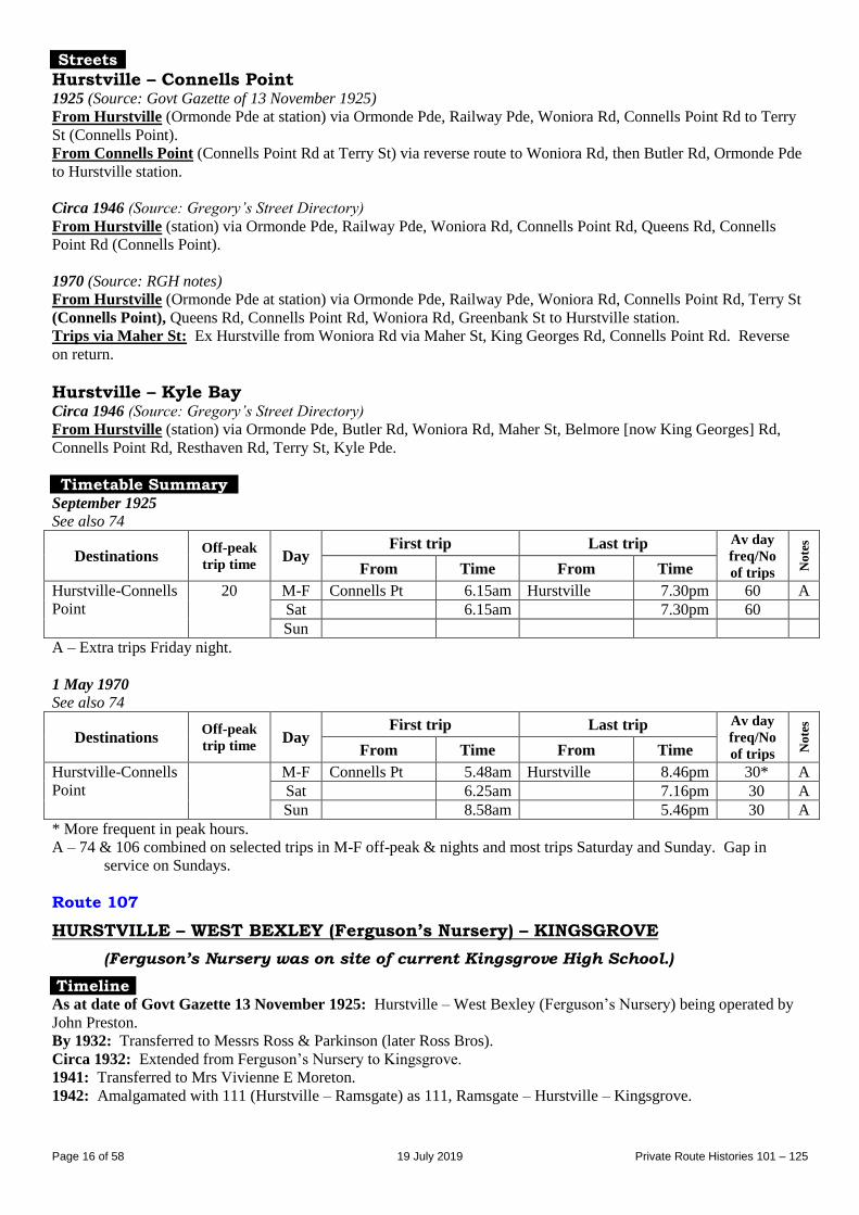
Timetable Summary September 1925
See also 74
Destinations Off-peak
trip time Day
First trip Last trip Av day
freq/No
of trips No
tes
From Time From Time
Hurstville-Connells
Point
20 M-F Connells Pt 6.15am Hurstville 7.30pm 60 A
Sat 6.15am 7.30pm 60
Sun
A – Extra trips Friday night.
1 May 1970 See also 74
Destinations Off-peak
trip time Day
First trip Last trip Av day
freq/No
of trips No
tes
From Time From Time
Hurstville-Connells
Point
M-F Connells Pt 5.48am Hurstville 8.46pm 30* A
Sat 6.25am 7.16pm 30 A
Sun 8.58am 5.46pm 30 A
* More frequent in peak hours.
A – 74 & 106 combined on selected trips in M-F off-peak & nights and most trips Saturday and Sunday. Gap in
service on Sundays.
Route 107
HURSTVILLE – WEST BEXLEY (Ferguson’s Nursery) – KINGSGROVE
(Ferguson’s Nursery was on site of current Kingsgrove High School.)
Timeline As at date of Govt Gazette 13 November 1925: Hurstville – West Bexley (Ferguson’s Nursery) being operated by
John Preston.
By 1932: Transferred to Messrs Ross & Parkinson (later Ross Bros).
Circa 1932: Extended from Ferguson’s Nursery to Kingsgrove.
1941: Transferred to Mrs Vivienne E Moreton.
1942: Amalgamated with 111 (Hurstville – Ramsgate) as 111, Ramsgate – Hurstville – Kingsgrove.
Page 17 of 58 19 July 2019 Private Route Histories 101 – 125
Streets 1925 (Source: Govt Gazette of 13 November 1925) From Hurstville (Railway Square at station) via Forest Rd, McMahon St, Park Rd, Queens Rd, The Avenue, Bristol
St, Clevedon St, Kimberley Rd, Croydon Rd to Stoney Creek Rd (Ferguson’s Nursery [site of current Kingsgrove
High School], West Bexley). Reverse on return.
Alteration
1927 (Source: Govt Gazette of 27 May 1927): Extended from Railway Square, Hurstville via Forest Rd, Rose St to
Forest Rd (Hurstville). Reverse on return.
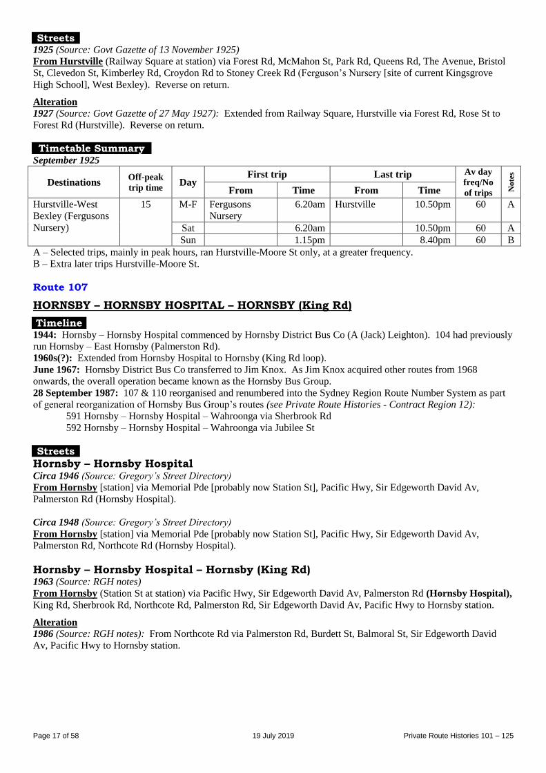
Timetable Summary September 1925
Destinations Off-peak
trip time Day
First trip Last trip Av day
freq/No
of trips No
tes
From Time From Time
Hurstville-West
Bexley (Fergusons
Nursery)
15 M-F Fergusons
Nursery
6.20am Hurstville 10.50pm 60 A
Sat 6.20am 10.50pm 60 A
Sun 1.15pm 8.40pm 60 B
A – Selected trips, mainly in peak hours, ran Hurstville-Moore St only, at a greater frequency.
B – Extra later trips Hurstville-Moore St.
Route 107
HORNSBY – HORNSBY HOSPITAL – HORNSBY (King Rd)
Timeline 1944: Hornsby – Hornsby Hospital commenced by Hornsby District Bus Co (A (Jack) Leighton). 104 had previously
run Hornsby – East Hornsby (Palmerston Rd).
1960s(?): Extended from Hornsby Hospital to Hornsby (King Rd loop).
June 1967: Hornsby District Bus Co transferred to Jim Knox. As Jim Knox acquired other routes from 1968
onwards, the overall operation became known as the Hornsby Bus Group.
28 September 1987: 107 & 110 reorganised and renumbered into the Sydney Region Route Number System as part
of general reorganization of Hornsby Bus Group’s routes (see Private Route Histories - Contract Region 12):
591 Hornsby – Hornsby Hospital – Wahroonga via Sherbrook Rd
592 Hornsby – Hornsby Hospital – Wahroonga via Jubilee St
Streets
Hornsby – Hornsby Hospital Circa 1946 (Source: Gregory’s Street Directory)
From Hornsby [station] via Memorial Pde [probably now Station St], Pacific Hwy, Sir Edgeworth David Av,
Palmerston Rd (Hornsby Hospital).
Circa 1948 (Source: Gregory’s Street Directory)
From Hornsby [station] via Memorial Pde [probably now Station St], Pacific Hwy, Sir Edgeworth David Av,
Palmerston Rd, Northcote Rd (Hornsby Hospital).
Hornsby – Hornsby Hospital – Hornsby (King Rd) 1963 (Source: RGH notes)
From Hornsby (Station St at station) via Pacific Hwy, Sir Edgeworth David Av, Palmerston Rd (Hornsby Hospital),
King Rd, Sherbrook Rd, Northcote Rd, Palmerston Rd, Sir Edgeworth David Av, Pacific Hwy to Hornsby station.
Alteration
1986 (Source: RGH notes): From Northcote Rd via Palmerston Rd, Burdett St, Balmoral St, Sir Edgeworth David
Av, Pacific Hwy to Hornsby station.
Page 18 of 58 19 July 2019 Private Route Histories 101 – 125
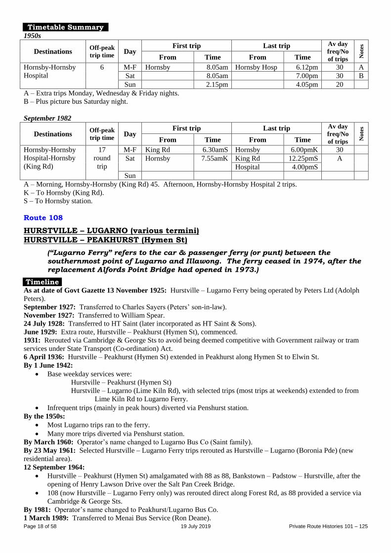
Timetable Summary 1950s
Destinations Off-peak
trip time Day
First trip Last trip Av day
freq/No
of trips No
tes
From Time From Time
Hornsby-Hornsby
Hospital
6 M-F Hornsby 8.05am Hornsby Hosp 6.12pm 30 A
Sat 8.05am 7.00pm 30 B
Sun 2.15pm 4.05pm 20
A – Extra trips Monday, Wednesday & Friday nights.
B – Plus picture bus Saturday night.
September 1982
Destinations Off-peak
trip time Day
First trip Last trip Av day
freq/No
of trips No
tes
From Time From Time
Hornsby-Hornsby
Hospital-Hornsby
(King Rd)
17
round
trip
M-F King Rd 6.30amS Hornsby 6.00pmK 30
Sat Hornsby 7.55amK King Rd 12.25pmS A
Hospital 4.00pmS
Sun
A – Morning, Hornsby-Hornsby (King Rd) 45. Afternoon, Hornsby-Hornsby Hospital 2 trips.
K – To Hornsby (King Rd).
S – To Hornsby station.
Route 108
HURSTVILLE – LUGARNO (various termini) HURSTVILLE – PEAKHURST (Hymen St)
(“Lugarno Ferry” refers to the car & passenger ferry (or punt) between the
southernmost point of Lugarno and Illawong. The ferry ceased in 1974, after the
replacement Alfords Point Bridge had opened in 1973.)
Timeline As at date of Govt Gazette 13 November 1925: Hurstville – Lugarno Ferry being operated by Peters Ltd (Adolph
Peters).
September 1927: Transferred to Charles Sayers (Peters’ son-in-law).
November 1927: Transferred to William Spear.
24 July 1928: Transferred to HT Saint (later incorporated as HT Saint & Sons).
June 1929: Extra route, Hurstville – Peakhurst (Hymen St), commenced.
1931: Rerouted via Cambridge & George Sts to avoid being deemed competitive with Government railway or tram
services under State Transport (Co-ordination) Act.
6 April 1936: Hurstville – Peakhurst (Hymen St) extended in Peakhurst along Hymen St to Elwin St.
By 1 June 1942:
Base weekday services were:
Hurstville – Peakhurst (Hymen St)
Hurstville – Lugarno (Lime Kiln Rd), with selected trips (most trips at weekends) extended to from
Lime Kiln Rd to Lugarno Ferry.
Infrequent trips (mainly in peak hours) diverted via Penshurst station.
By the 1950s:
Most Lugarno trips ran to the ferry.
Many more trips diverted via Penshurst station.
By March 1960: Operator’s name changed to Lugarno Bus Co (Saint family).
By 23 May 1961: Selected Hurstville – Lugarno Ferry trips rerouted as Hurstville – Lugarno (Boronia Pde) (new
residential area).
12 September 1964:
Hurstville – Peakhurst (Hymen St) amalgamated with 88 as 88, Bankstown – Padstow – Hurstville, after the
opening of Henry Lawson Drive over the Salt Pan Creek Bridge.
108 (now Hurstville – Lugarno Ferry only) was rerouted direct along Forest Rd, as 88 provided a service via
Cambridge & George Sts.
By 1981: Operator’s name changed to Peakhurst/Lugarno Bus Co.
1 March 1989: Transferred to Menai Bus Service (Ron Deane).
Page 19 of 58 19 July 2019 Private Route Histories 101 – 125
July 1989: Operator’s name altered to Southtrans.
14 August 1989: Transferred to Punchbowl Bus Co (Griffin family/Steve Scott).
By 1990: Hurstville – Lugarno Ferry trips curtailed to Tate Pl, Lugarno, by way of a delayed response to the cessation
of the Lugarno-Illawong Ferry in 1974.
18 August 1997: Renumbered 943 in the Sydney Region Route Number System (see Private Route Histories -
Contract Region 5).
Streets
Hurstville – Lugarno Ferry 1925 (Source: Govt Gazette of 13 November 1925) From Hurstville (Railway Square at station) via Forest Rd, Penshurst St [to Penshurst station & return], Forest Rd
(Peakhurst) to Georges River (Lugarno Ferry). Reverse on return.
1927 (Source: Govt Gazette of 27 May 1927)
From Hurstville (Rose St at Forest Rd) via Rose St, Forest Rd, Penshurst St [to Penshurst station & return], Forest
Rd (Peakhurst) to Georges River (Lugarno Ferry). Reverse on return.
Circa 1946 (Source: Gregory’s Street Directory)
From Hurstville (station) via Tracey [now Treacy] St, Forest Rd (Peakhurst), Cambridge St, George St, Forest Rd
(Peakhurst) to Lugarno [Ferry].
Trips to/from Penshurst station: From Penshurst station via Railway Pde [now Bridge St], Penshurst St, Forest Rd
(Peakhurst) to Lugarno.
Circa 1948 (Source: Gregory’s Street Directory)
From Hurstville (station) via Tracey [now Treacy] St, Forest Rd, Cambridge St, George St, Forest Rd (Peakhurst) to
Lugarno [Ferry].
1970 (Source: RGH notes)
From Hurstville (Treacey St) via Forest Rd, Connelly St, Bridge St (Penshurst), Penshurst St, Forest Rd
(Peakhurst) to Lugarno Ferry.
From Lugarno (Forest Rd at Ferry) via reverse route to Connelly St, then Forest Rd, Alfred St, Treacy St
(Hurstville).
Hurstville – Lugarno (Tate Pl) Alteration
By 1990 (Source: timetable): Lugarno Ferry terminus altered to Forest Rd at Tate Pl.
Hurstville – Lugarno (Boronia Pde) 1970 (Source: RGH notes)
From Hurstville (Treacey St) via Forest Rd, Connelly St, Bridge St, Penshurst St, Forest Rd (Peakhurst), Lime Kiln
Rd, Woodlands Av to Boronia Pde (Lugarno).
From Lugarno (Woodlands Av at Boronia Pde) via reverse route to Connelly St, then Forest Rd, Alfred St, Treacy St
(Hurstville).
Hurstville – Peakhurst (Hymen St) 1927 (Source: Govt Gazette of 27 May 1927) From Hurstville (Rose St at Forest Rd) via Rose St, Forest Rd, Penshurst St to Penshurst station & return, Forest Rd,
Hymen St [now Henry Lawson Dr] to Belmore Rd (Peakhurst). Reverse on return.
Page 20 of 58 19 July 2019 Private Route Histories 101 – 125
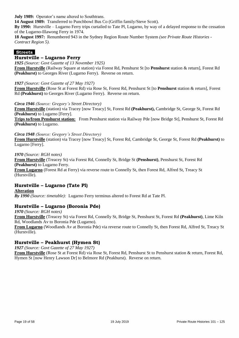
Timetable Summary 1 June 1942
Destinations Off-peak
trip time Day
First trip Last trip Av day
freq/No
of trips No
tes
From Time From Time
Hurstville-Lugarno
(various termini)
23 M-F Lugarno 6.02am Hurstville† 7.30pm A
Sat 6.00am 7.35pm B
Sun Hurstville 9.11am Lugarno Ferry 8.39pm 60 C
Hurstville-
Peakhurst (Hymen
St)
18 M-F Hymen St 6.42am Hurstville† 6.31pm 60
Sat 8.30am 6.56pm 14 trips D
Sun 7.16am Hymen St 1.50pm E
* More frequent in peak hours.
† Penshurst in peak hours.
A – Hurstville-Forest Rd/Hymen St 60, Hurstville-Lime Kiln Rd 120, Hurstville-Lugarno Ferry 5 trips.
B – Hurstville-Lime Kiln Rd: 9 trips from Lime Kiln Rd, 8 trips from Hurstville; Hurstville-Lugarno Ferry 5 trips.
Plus picture bus Saturday night.
C – Plus short-working/s before first trip and after last trip shown.
D – Plus picture bus Saturday night.
E – 3 trips from Peakhurst (Hymen St), 1 trip from Penshurst.
18 June 1951
Destinations Off-peak
trip time Day
First trip Last trip Av day
freq/No
of trips No
tes
From Time From Time
Hurstville-Lugarno
(various termini)
27 M-F Lugarno 5.50am Hurstville† 11.05pm A
Sat 7.03am 11.05pm B
Sun Hurstville 7.40am 10.05pm 30 C
Hurstville-
Peakhurst (Hymen
St)
22 M-F Hymen St 6.04am Hurstville 11.05pm 30* D
Sat 7.12am 10.05pm 30 E
Sun 7.15am 10.05pm 4 trips F
* More frequent in peak hours.
† Penshurst in peak hours.
A – Day, Hurstville-Lugarno (Lime Kiln Rd) 30*, Hurstville-Lugarno Ferry 60. Night, Hurstville-Lugarno (Lime
Kiln Rd).
B – Morning, Hurstville-Baumans Rd 4 trips her hour, Hurstville-Lugrno Ferry 30. Afternoons, Hurstville-Lugarno
Ferry 30. Night, Hurstville-Lugarno (Lime Kiln Rd).
C – Day & most night trips, Hurstville-Lugarno Ferry.
D – Includes night trips to Lugarno diverted via Hymen St on request.
E – Gap in service. Includes early morning & night trips to Lugarno diverted via Hymen St on request. Plus picture
bus Saturday night.
F – Includes night trip to Lugarno diverted via Hymen St on request.
14 July 1968
Destinations Off-peak
trip time Day
First trip Last trip Av day
freq/No
of trips No
tes
From Time From Time
Hurstville-Lugarno
(various termini)
24 M-F Lugarno 6.10am Hurstville 9.20pm 30*
Sat 6.50am 10.50pm AM 30
PM 60
A
Sun 7.14am 8.10pm 60
Lugarno termini: On weekdays (daytime) & Saturday mornings generally alternate trips ran to Lugarno Ferry &
Boronia Pde. Some early morning trips & those at night ran to Lime Kiln Rd only. On Saturday afternoons
and all day Sunday all trips ran to Lugarno Ferry.
* More frequent in peak hours.
A – Plus picture bus Saturday night.
Page 21 of 58 19 July 2019 Private Route Histories 101 – 125
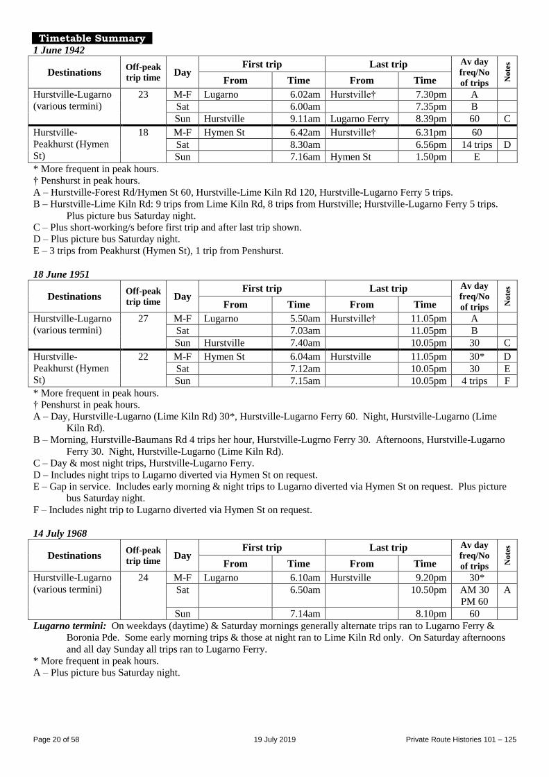
Route 109
HURSTVILLE – MORTDALE – OATLEY (Short St)
Timeline As at date of Govt Gazette 13 November 1925: Being operated by Peters Ltd (Adolph Peters).
By date of Govt Gazette 15 October 1926: Ceased.
Streets 1925 (Source: Govt Gazette of 13 November 1925) From Hurstville (Railway Square at station) via Forest Rd, Penshurst St, Victoria Av, Morts Rd (Mortdale), Pitt St,
Woronora Pde, Mulga St [now Rd], Gungah Bay Rd, Lloyd George [now Lloyd] St to Short St (Oatley). Reverse on
return.
Timetable Summary September 1925
Destinations Off-peak
trip time Day
First trip Last trip Av day
freq/No
of trips No
tes
From Time From Time
Hurstville-Oatley
(Short St)
18 M-F Short St 8.45am Hurstville 4.45pm 60
Sat 8.45am 4.45pm 60
Sun
Route 109
HURSTVILLE – CARSS PARK via various routes HURSTVILLE – GEORGE & WEST STS
(Conway Rd is now the southern end of Woniora Rd.)
Timeline 1930s: Hurstville – Carss Park Entrance (via Park Rd ?) commenced by Terence M Jamieson, then or later trading as
Jamieson Bus Service. (A list dated October 1935 shows operator as Mrs EM Jamieson.) Shared parts of route at
different times with 197 & 228.
21 February 1952: Terence Jamieson died and ownership passed to his family.
By 27 July 1953:
New route, Hurstville – George & West Sts, commenced.
Hurstville – Carss Park via Conway Rd renumbered from 228.
Routes were:
Hurstville – Carss Park via Conway Rd
Hurstville – Carss Park via Park Rd
Hurstville – George & West Sts
Circa 1960: Hurstville – Carss Park via Conway Rd & Hurstville – Carss Park via Park Rd rearranged into a sinlge
route running in a loop Hurstville – Carss Park & return (normally from Hurstville via Bellevue Pde & Lower West St
& return from Carss Park via Conway Rd & Woniora Rd between Princes Hwy & Blakeskey Rd). Service to the Park
Rd area provided by existing 197.
9 September 1976: Transferred to Green’s Bus Lines (Fred Green).
1978: Green’s Bus Lines transferred to AA (Alan) Witham (also trading as Carss Coaches).
December 1984: Green’s Bus Lines transferred to O’Nains family.
December 1987: Transferred to Green’s Charter (Deborah Jane Unwin).
2 June 1989: Transferred to Carss Park Charter Tours (O’Nains family).
By 2 March 1992: Renumbered 958 in the Sydney Region Route Number System (see Private Route Histories -
Contract Region 10/11).
Streets
Hurstville – Carss Park via Park Rd Circa 1946 (Source: Gregory’s Street Directory)
From Hurstville (station) via Ormonde Pde, Butler Rd, Woniora Rd, Connells Point Rd, Belmore [now King
Georges] Rd, Blakesley Rd, Woids Av, Planthurst Rd, Park Rd, Princes Hwy, Carwar Av (Carss Park).
Page 22 of 58 19 July 2019 Private Route Histories 101 – 125
Circa 1948 (Source: Gregory’s Street Directory)
From Hurstville (station) via Ormonde Pde, Railway St, Woniora Rd, Connells Point Rd, Belmore [now King
Georges] Rd, Blakesley Rd, Woids Av, Planthurst Rd, Park Rd, Princes Hwy, Carwar Av (Carss Park).
Hurstville – Carss Park via Bellevue Pde & return via Woniora Rd 1970 (Source: RGH notes)
From Hurstville (Ormonde Pde at station) via Railway Pde, Woniora Rd, Connells Point Rd, Blakesley Rd, Woids
Av, Planthurst Rd, Bellevue Pde, Lower West St, Princes Hwy (Carss Park), Woniora Rd, Blakesley Rd, Connells
Point Rd, Woniora Rd, Greenbank St, Ormonde Pde to Hurstville station.
Carss Park entrance diversion (originally selected trips, later all trips): From Princes Hwy/Carwar Av via Carwar
Av to Carss Bush Park entrance & return.
Alteration
1986 (Source: RGH notes): To approach Hurtstville station from Woniora Rd via Butlers Rd (not Greenbank St),
Ormonde Pde. Return from Hurstville (Ormonde Pde) via West St, Cole St, Woniora Rd.
Hurstville – George & West Sts 1970 (Source: RGH notes)
From Hurstville (Ormonde Pde at station) via Railway Pde, West St, Cole St, George St, King St, West St, Railway
Pde, Woniora Rd, Greenbank St, Ormonde Pde to Hurstville station.
Alteration
1986 (Source: RGH notes): To approach Hurtstville station from West St via Cole St, Woniora Rd, Butlers Rd,
Ormonde Pde.
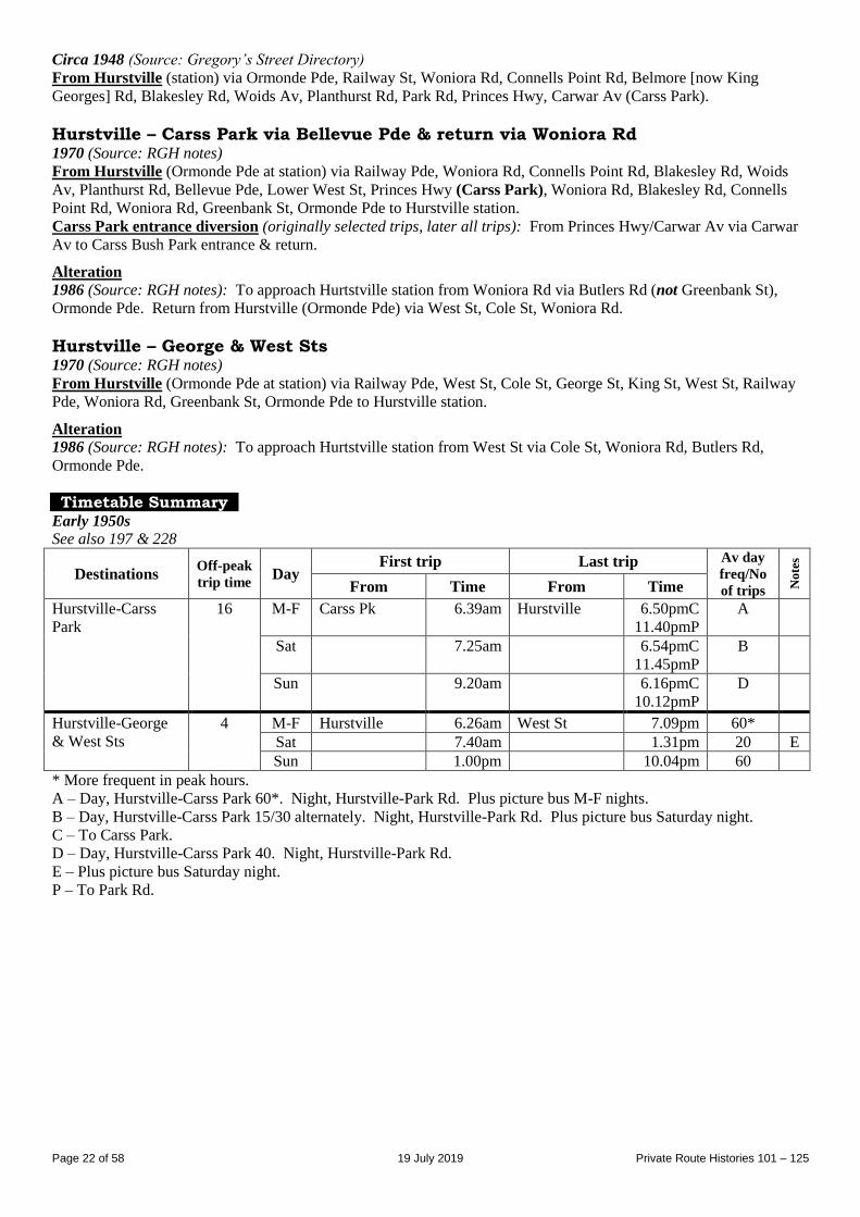
Timetable Summary Early 1950s See also 197 & 228
Destinations Off-peak
trip time Day
First trip Last trip Av day
freq/No
of trips No
tes
From Time From Time
Hurstville-Carss
Park
16 M-F Carss Pk 6.39am Hurstville 6.50pmC
11.40pmP
A
Sat 7.25am 6.54pmC
11.45pmP
B
Sun 9.20am 6.16pmC
10.12pmP
D
Hurstville-George
& West Sts
4 M-F Hurstville 6.26am West St 7.09pm 60*
Sat 7.40am 1.31pm 20 E
Sun 1.00pm 10.04pm 60
* More frequent in peak hours.
A – Day, Hurstville-Carss Park 60*. Night, Hurstville-Park Rd. Plus picture bus M-F nights.
B – Day, Hurstville-Carss Park 15/30 alternately. Night, Hurstville-Park Rd. Plus picture bus Saturday night.
C – To Carss Park.
D – Day, Hurstville-Carss Park 40. Night, Hurstville-Park Rd.
E – Plus picture bus Saturday night.
P – To Park Rd.
Page 23 of 58 19 July 2019 Private Route Histories 101 – 125
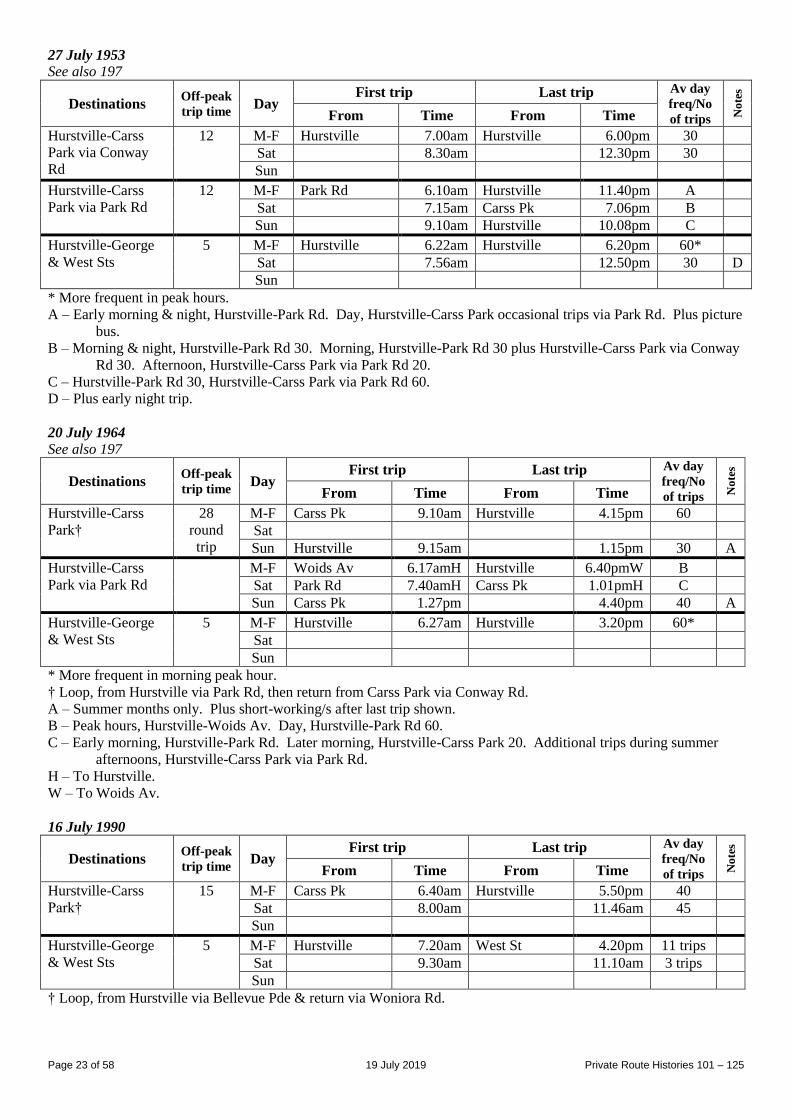
27 July 1953
See also 197
Destinations Off-peak
trip time Day
First trip Last trip Av day
freq/No
of trips No
tes
From Time From Time
Hurstville-Carss
Park via Conway
Rd
12 M-F Hurstville 7.00am Hurstville 6.00pm 30
Sat 8.30am 12.30pm 30
Sun
Hurstville-Carss
Park via Park Rd
12 M-F Park Rd 6.10am Hurstville 11.40pm A
Sat 7.15am Carss Pk 7.06pm B
Sun 9.10am Hurstville 10.08pm C
Hurstville-George
& West Sts
5 M-F Hurstville 6.22am Hurstville 6.20pm 60*
Sat 7.56am 12.50pm 30 D
Sun
* More frequent in peak hours.
A – Early morning & night, Hurstville-Park Rd. Day, Hurstville-Carss Park occasional trips via Park Rd. Plus picture
bus.
B – Morning & night, Hurstville-Park Rd 30. Morning, Hurstville-Park Rd 30 plus Hurstville-Carss Park via Conway
Rd 30. Afternoon, Hurstville-Carss Park via Park Rd 20.
C – Hurstville-Park Rd 30, Hurstville-Carss Park via Park Rd 60.
D – Plus early night trip.
20 July 1964
See also 197
Destinations Off-peak
trip time Day
First trip Last trip Av day
freq/No
of trips No
tes
From Time From Time
Hurstville-Carss
Park†
28
round
trip
M-F Carss Pk 9.10am Hurstville 4.15pm 60
Sat
Sun Hurstville 9.15am 1.15pm 30 A
Hurstville-Carss
Park via Park Rd
M-F Woids Av 6.17amH Hurstville 6.40pmW B
Sat Park Rd 7.40amH Carss Pk 1.01pmH C
Sun Carss Pk 1.27pm 4.40pm 40 A
Hurstville-George
& West Sts
5 M-F Hurstville 6.27am Hurstville 3.20pm 60*
Sat
Sun
* More frequent in morning peak hour.
† Loop, from Hurstville via Park Rd, then return from Carss Park via Conway Rd.
A – Summer months only. Plus short-working/s after last trip shown.
B – Peak hours, Hurstville-Woids Av. Day, Hurstville-Park Rd 60.
C – Early morning, Hurstville-Park Rd. Later morning, Hurstville-Carss Park 20. Additional trips during summer
afternoons, Hurstville-Carss Park via Park Rd.
H – To Hurstville.
W – To Woids Av.
16 July 1990
Destinations Off-peak
trip time Day
First trip Last trip Av day
freq/No
of trips No
tes
From Time From Time
Hurstville-Carss
Park†
15 M-F Carss Pk 6.40am Hurstville 5.50pm 40
Sat 8.00am 11.46am 45
Sun
Hurstville-George
& West Sts
5 M-F Hurstville 7.20am West St 4.20pm 11 trips
Sat 9.30am 11.10am 3 trips
Sun
† Loop, from Hurstville via Bellevue Pde & return via Woniora Rd.
Page 24 of 58 19 July 2019 Private Route Histories 101 – 125
Route 110
HURLSTONE PARK – MARRICKVILLE – LEICHHARDT
Timeline As at date of Govt Gazette 13 November 1925: Being operated by (1) Joseph Northey, (2) WB Brady & (3) Mick
Fitzgibbons (also trading as White Deluxe Bus Service).
31 October 1931: Ceased as competitive with Government railway or tram services under State Transport (Co-
ordination) Act.
Streets 1925 (Source: Govt Gazette of 13 November 1925) From Hurlstone Park (Floss St at station) via Floss St, Garnet St, Ewart St, Beauchamp St, Warren Rd, Illawarra Rd
(Marrickville), Marrickville Rd, Livingstone Rd, New Canterbury Rd, Palace [now Audley] St, Trafalgar St
(Petersham), Crystal St, Croydon St, Railway St, Parramatta Rd to Norton St (Leichhardt).
From Leichhardt (Parramatta Rd at Norton St) via Parramatta Rd, Crystal St, then reverse route to Hurlstone Park
station.
Alteration
1920s?: Undated timetable shows Hurlstone Park terminus at Terrace Rd (no other details listed).
Timetable Summary September 1925
Destinations Off-peak
trip time Day
First trip Last trip Av day
freq/No
of trips No
tes
From Time From Time
Hurlstone Park-
Leichhardt
23 M-F Hurlstone Pk 7.55am Leichhardt 11.20pm AM 60
PM 30
Sat 7.55am 11.20pm AM 60
PM 30
Sun 7.55am 11.20pm AM 60
PM 30
Undated (1920s?)
Destinations Off-peak
trip time Day
First trip Last trip Av day
freq/No
of trips No
tes
From Time From Time
Hurlstone Park-
Leichhardt
40
round
trip
M-F Hurlstone Pk 8.20am Leichhardt 10.47pm 30
Sat 8.20am 10.47pm 30
Sun 8.50am 10.47pm AM 60
PM 30
Route 110
HORNSBY – WAHROONGA
Timeline 1947: Commenced by Hornsby District Bus Co (AJ (Jack) Leighton).
June 1967: Hornsby District Bus Co transferred to Jim Knox. As Jim Knox acquired other routes from 1968
onwards, the overall operation became known as the Hornsby Bus Group.
By May 1975: Routes rearranged as:
Hornsby – Wahroonga via Burdett St
Hornsby – Wahroonga via King Rd.
28 September 1987: 107 & 110 reorganised and renumbered into the Sydney Region Route Number System as part
of general reorganization of Hornsby Bus Group’s routes (see Private Route Histories - Contract Region 12):
591 Hornsby – Hornsby Hospital – Wahroonga via Sherbrook Rd
592 Hornsby – Hornsby Hospital – Wahroonga via Jubilee St
Streets Circa 1948 (Source: Gregory’s Street Directory)
From Hornsby (station) via George St, Florence St, Albert St, Burdett St, Jubilee St, Sir Edgeworth David Av,
Coonanbarra Rd, Millewa Av (Wahroonga).
Page 25 of 58 19 July 2019 Private Route Histories 101 – 125
1963 (Source: RGH notes)
From Hornsby (George St at station) via Burdett St, Hunter St, Linda St, Muriel St, Burdett St, Jubilee St, Edgeworth
David Av, Coonanbarra Rd, Millewa Av to Wahroonga station.
From Wahroonga (Millewa Av at station) via Illoura Av, Stuart St, Coonanbarra Rd, then reverse route to Hunter St,
then Florence St, George St to Hornsby station.
1986 (Source: RGH notes)
Via Burdett St From Hornsby (Station St at station) via Pacific Hwy, Edgeworth David Av, Muriel St, Burdett St, Jubilee St,
Edgeworth David Av, Coonanbarra Rd, Millewa Av to Wahroonga station.
From Wahroonga (Millewa Av at station) via Illoura Av, Stuart St, Coonanbarra Rd, then reverse route to Burdett St,
then Sherbrook Rd, Bridge Rd, Jersey St, Station St to Hornsby station.
Via King Rd From Hornsby (Station St at station) via Pacific Hwy, Edgeworth David Av, Muriel St, Burdett St, Sherbrook Rd,
King Rd, Burdett St, Jubilee St, Edgeworth David Av, Coonanbarra Rd, Millewa Av to Wahroonga station.
From Wahroonga (Millewa Av at station) via Illoura Av, Stuart St, Coonanbarra Rd, then reverse route to King Rd,
then Bridge Rd, Jersey St, Station St to Hornsby station.
Timetable Summary 13 September 1960
Destinations Off-peak
trip time Day
First trip Last trip Av day
freq/No
of trips No
tes
From Time From Time
Hornsby-
Wahroonga
12 M-F Hornsby 7.20am Wahroonga 6.40pm 60* A
Sat 9.00am 10.45am 30 B
Sun
* More frequent in peak hours.
A – Gap in service. Selected peak hour trips ran Wahroonga-Palmerston Rd.
B – Plus short-working/s before first trip and after last trip shown.
September 1984
Destinations Off-peak
trip time Day
First trip Last trip Av day
freq/No
of trips No
tes
From Time From Time
Hornsby-
Wahroonga
10 M-F Hornsby 7.05am Wahroonga 6.30pm 14 trips A
Sat
Sun
A – Gap in service. Selected peak hour trips ran Wahroonga-Palmerston Rd.
Route 111
HURSTVILLE – MORTDALE – OATLEY (Rosa St) [now Oatley Bay]
Timeline As at date of Govt Gazette 13 November 1925: Being operated by Peters Ltd (Adolph Peters).
By date of Govt Gazette 17 December 1926: Ceased.
Streets 1925 (Source: Govt Gazette of 13 November 1925) From Hurstville (Railway Square at station) via Forest Rd, Penshurst St, Victoria Av, Morts Rd (Mortdale), Pitt St,
Woronora Pde, Wonoona Pde, Oatley Pde, Frederick St, Letitia St, Neville St, Rosa St to Algernon St (Oatley).
Reverse on return.
Page 26 of 58 19 July 2019 Private Route Histories 101 – 125
Timetable Summary September 1925
Destinations Off-peak
trip time Day
First trip Last trip Av day
freq/No
of trips No
tes
From Time From Time
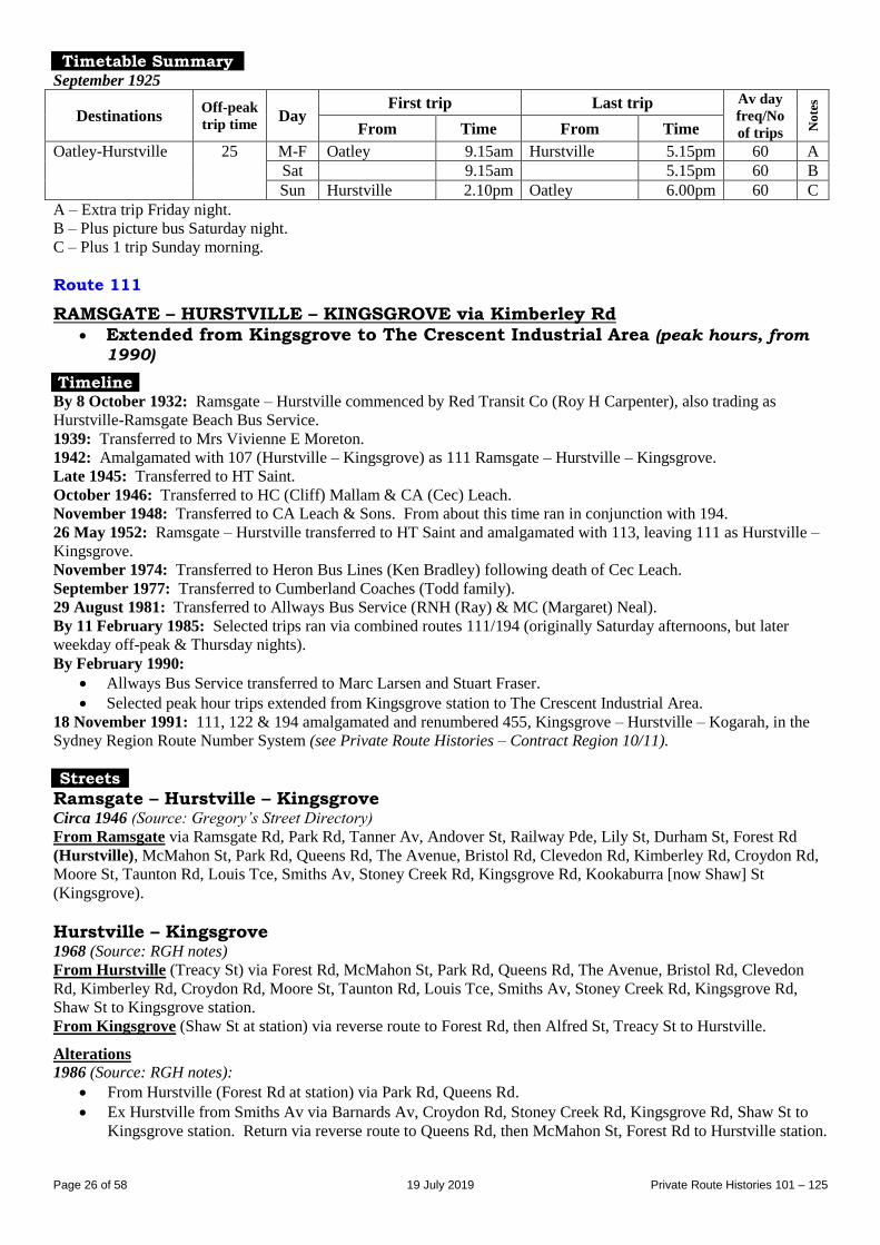
Oatley-Hurstville 25 M-F Oatley 9.15am Hurstville 5.15pm 60 A
Sat 9.15am 5.15pm 60 B
Sun Hurstville 2.10pm Oatley 6.00pm 60 C
A – Extra trip Friday night.
B – Plus picture bus Saturday night.
C – Plus 1 trip Sunday morning.
Route 111
RAMSGATE – HURSTVILLE – KINGSGROVE via Kimberley Rd Extended from Kingsgrove to The Crescent Industrial Area (peak hours, from
1990)
Timeline By 8 October 1932: Ramsgate – Hurstville commenced by Red Transit Co (Roy H Carpenter), also trading as
Hurstville-Ramsgate Beach Bus Service.
1939: Transferred to Mrs Vivienne E Moreton.
1942: Amalgamated with 107 (Hurstville – Kingsgrove) as 111 Ramsgate – Hurstville – Kingsgrove.
Late 1945: Transferred to HT Saint.
October 1946: Transferred to HC (Cliff) Mallam & CA (Cec) Leach.
November 1948: Transferred to CA Leach & Sons. From about this time ran in conjunction with 194.
26 May 1952: Ramsgate – Hurstville transferred to HT Saint and amalgamated with 113, leaving 111 as Hurstville –
Kingsgrove.
November 1974: Transferred to Heron Bus Lines (Ken Bradley) following death of Cec Leach.
September 1977: Transferred to Cumberland Coaches (Todd family).
29 August 1981: Transferred to Allways Bus Service (RNH (Ray) & MC (Margaret) Neal).
By 11 February 1985: Selected trips ran via combined routes 111/194 (originally Saturday afternoons, but later
weekday off-peak & Thursday nights).
By February 1990:
Allways Bus Service transferred to Marc Larsen and Stuart Fraser.
Selected peak hour trips extended from Kingsgrove station to The Crescent Industrial Area.
18 November 1991: 111, 122 & 194 amalgamated and renumbered 455, Kingsgrove – Hurstville – Kogarah, in the
Sydney Region Route Number System (see Private Route Histories – Contract Region 10/11).
Streets
Ramsgate – Hurstville – Kingsgrove Circa 1946 (Source: Gregory’s Street Directory)
From Ramsgate via Ramsgate Rd, Park Rd, Tanner Av, Andover St, Railway Pde, Lily St, Durham St, Forest Rd
(Hurstville), McMahon St, Park Rd, Queens Rd, The Avenue, Bristol Rd, Clevedon Rd, Kimberley Rd, Croydon Rd,
Moore St, Taunton Rd, Louis Tce, Smiths Av, Stoney Creek Rd, Kingsgrove Rd, Kookaburra [now Shaw] St
(Kingsgrove).
Hurstville – Kingsgrove 1968 (Source: RGH notes)
From Hurstville (Treacy St) via Forest Rd, McMahon St, Park Rd, Queens Rd, The Avenue, Bristol Rd, Clevedon
Rd, Kimberley Rd, Croydon Rd, Moore St, Taunton Rd, Louis Tce, Smiths Av, Stoney Creek Rd, Kingsgrove Rd,
Shaw St to Kingsgrove station.
From Kingsgrove (Shaw St at station) via reverse route to Forest Rd, then Alfred St, Treacy St to Hurstville.
Alterations
1986 (Source: RGH notes):
From Hurstville (Forest Rd at station) via Park Rd, Queens Rd.
Ex Hurstville from Smiths Av via Barnards Av, Croydon Rd, Stoney Creek Rd, Kingsgrove Rd, Shaw St to
Kingsgrove station. Return via reverse route to Queens Rd, then McMahon St, Forest Rd to Hurstville station.
Page 27 of 58 19 July 2019 Private Route Histories 101 – 125
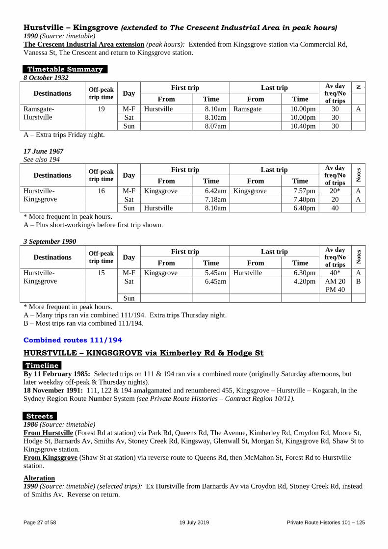
Hurstville – Kingsgrove (extended to The Crescent Industrial Area in peak hours) 1990 (Source: timetable)
The Crescent Industrial Area extension (peak hours): Extended from Kingsgrove station via Commercial Rd,
Vanessa St, The Crescent and return to Kingsgrove station.
Timetable Summary 8 October 1932
Destinations Off-peak
trip time Day
First trip Last trip Av day
freq/No
of trips
N o t e s
From Time From Time
Ramsgate-
Hurstville
19 M-F Hurstville 8.10am Ramsgate 10.00pm 30 A
Sat 8.10am 10.00pm 30
Sun 8.07am 10.40pm 30
A – Extra trips Friday night.
17 June 1967
See also 194
Destinations Off-peak
trip time Day
First trip Last trip Av day
freq/No
of trips No
tes
From Time From Time
Hurstville-
Kingsgrove
16 M-F Kingsgrove 6.42am Kingsgrove 7.57pm 20* A
Sat 7.18am 7.40pm 20 A
Sun Hurstville 8.10am 6.40pm 40
* More frequent in peak hours.
A – Plus short-working/s before first trip shown.
3 September 1990
Destinations Off-peak
trip time Day
First trip Last trip Av day
freq/No
of trips No
tes
From Time From Time
Hurstville-
Kingsgrove
15 M-F Kingsgrove 5.45am Hurstville 6.30pm 40* A
Sat 6.45am 4.20pm AM 20
PM 40
B
Sun
* More frequent in peak hours.
A – Many trips ran via combined 111/194. Extra trips Thursday night.
B – Most trips ran via combined 111/194.
Combined routes 111/194
HURSTVILLE – KINGSGROVE via Kimberley Rd & Hodge St
Timeline By 11 February 1985: Selected trips on 111 & 194 ran via a combined route (originally Saturday afternoons, but
later weekday off-peak & Thursday nights).
18 November 1991: 111, 122 & 194 amalgamated and renumbered 455, Kingsgrove – Hurstville – Kogarah, in the
Sydney Region Route Number System (see Private Route Histories – Contract Region 10/11).
Streets
1986 (Source: timetable)
From Hurstville (Forest Rd at station) via Park Rd, Queens Rd, The Avenue, Kimberley Rd, Croydon Rd, Moore St,
Hodge St, Barnards Av, Smiths Av, Stoney Creek Rd, Kingsway, Glenwall St, Morgan St, Kingsgrove Rd, Shaw St to
Kingsgrove station.
From Kingsgrove (Shaw St at station) via reverse route to Queens Rd, then McMahon St, Forest Rd to Hurstville
station.
Alteration
1990 (Source: timetable) (selected trips): Ex Hurstville from Barnards Av via Croydon Rd, Stoney Creek Rd, instead
of Smiths Av. Reverse on return.
Page 28 of 58 19 July 2019 Private Route Histories 101 – 125
Route 112
BEVERLY HILLS – HURSTVILLE – ROCKDALE
Extended from Rockdale to Brighton-le-Sands (until 1931)
Timeline As at date of Govt Gazette 13 November 1925: Hurstville – Rockdale – Brighton-le-Sands being operated by Con
Iffland.
31 October 1931: Route classed as competitive under State Transport (Co-ordination) Act and split into two routes:
Rockdale – Bexley (Mimosa St) remained as 112
Willison Rd – Hurstville amalgamated with Harry Iffland’s 118 as 118 Bexley (Waratah St) – Hurstville –
East Dumbleton [now Hurstville] (Patrick St).
Rockdale – Brighton-le-Sands ceased.
December 1931: Rockdale – Bexley (Mimosa St) extended to Croydon Rd, thus overlapping 118 Bexley (Waratah
St) – Hurstville – East Dumbleton (Patrick St).
February 1932: 112 & 118 amalgamated as 112, Rockdale – Bexley – Hurstville – East Dumbleton (Patrick St).
29 November 1934: Operator incorporated as Pioneer Coaches.
June 1949: Extended from Patrick St to Beverly Hills.
December 1986: Pioneer Coaches transferred to the Harbridge family.
1 April 1997: Renumbered 452 in the Sydney Region Route Number System (see Private Route Histories - Contract
Region 10/11).
Streets
Hurstville – Rockdale – Brighton-le-Sands 1925 (Source: Govt Gazette of 13 November 1925) From Hurstville (Railway Square at station) via Forest Rd (Bexley), Harrow Rd, Watkins St, Frederick St, Railway
St (Rockdale), Frederick St, Bay St, Grand Pde to Bay St (Mondays to Saturdays) or near Princess St (Sundays &
Public Holidays) (Brighton-le-Sands).
From Brighton-le-Sands (Grand Pde) via Grand Pde, Princess St, The Avenue [now Moate Av], Bay St, then reverse
route to Hurstville station.
Alteration
1927 (Source: Govt Gazette of 27 May 1927): Extended from Hurstville station via Forest Rd, McMahon St to near
Forest Rd. Reverse on return.
Rockdale – Hurstville – Hurstville (Patrick St) Circa 1946 (Source: Gregory’s Street Directory)
From Rockdale [station] via Railway St, Frederick St, Watkin St, Harrow Rd, Forest Rd (Bexley), McMahon St,
Patrick St (Hurstville).
Rockdale – Hurstville – Beverly Hills Circa 1948 (Source: Gregory’s Street Directory)*
From Rockdale via Railway St, Frederick St, Watkin St, Harrow Rd, Forest Rd (Bexley, Hurstville), McMahon St,
Patrick St, Stoney Creek Rd, Gloucester Rd, Morgan St (Beverly Hills).
* The extension from Patrick St to Beverly Hills took place in June 1949, but the extension had probably been
approved in advance, hence its appearance in the circa 1948 Gregory’s Street Directory.
1970 (Source: RGH notes)
From Rockdale (Railway St at station) via Frederick St, Watkin St, Harrow Rd, Forest Rd (Bexley, Hurstville),
McMahon St, Patrick St, Stoney Creek Rd, Lee Av, Morgan St to Beverly Hills station.
From Beverly Hills (Morgan St at station) via King Georges Rd, Stoney Creek Rd, then reverse route to Watkin St,
then Walz St, Railway St to Rockdale station.
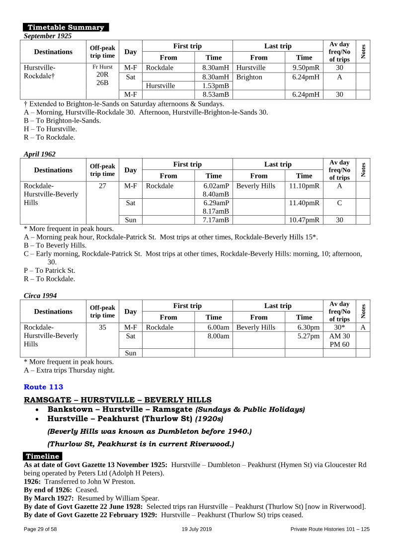
Page 29 of 58 19 July 2019 Private Route Histories 101 – 125
Timetable Summary September 1925
Destinations Off-peak
trip time Day
First trip Last trip Av day
freq/No
of trips No
tes
From Time From Time
Hurstville-
Rockdale†
Fr Hurst
20R
26B
M-F Rockdale 8.30amH Hurstville 9.50pmR 30 Sat 8.30amH Brighton 6.24pmH A
Hurstville 1.53pmB
M-F 8.53amB 6.24pmH 30 † Extended to Brighton-le-Sands on Saturday afternoons & Sundays.
A – Morning, Hurstville-Rockdale 30. Afternoon, Hurstville-Brighton-le-Sands 30.
B – To Brighton-le-Sands.
H – To Hurstville.
R – To Rockdale.
April 1962
Destinations Off-peak
trip time Day
First trip Last trip Av day
freq/No
of trips No
tes
From Time From Time
Rockdale-
Hurstville-Beverly
Hills
27 M-F Rockdale 6.02amP
8.40amB
Beverly Hills 11.10pmR A
Sat 6.29amP
8.17amB
11.40pmR C
Sun 7.17amB 10.47pmR 30
* More frequent in peak hours.
A – Morning peak hour, Rockdale-Patrick St. Most trips at other times, Rockdale-Beverly Hills 15*.
B – To Beverly Hills.
C – Early morning, Rockdale-Patrick St. Most trips at other times, Rockdale-Beverly Hills: morning, 10; afternoon,
30.
P – To Patrick St.
R – To Rockdale.
Circa 1994
Destinations Off-peak
trip time Day
First trip Last trip Av day
freq/No
of trips No
tes
From Time From Time
Rockdale-
Hurstville-Beverly
Hills
35 M-F Rockdale 6.00am Beverly Hills 6.30pm 30* A
Sat 8.00am 5.27pm AM 30
PM 60
Sun
* More frequent in peak hours.
A – Extra trips Thursday night.
Route 113
RAMSGATE – HURSTVILLE – BEVERLY HILLS Bankstown – Hurstville – Ramsgate (Sundays & Public Holidays)
Hurstville – Peakhurst (Thurlow St) (1920s)
(Beverly Hills was known as Dumbleton before 1940.)
(Thurlow St, Peakhurst is in current Riverwood.)
Timeline As at date of Govt Gazette 13 November 1925: Hurstville – Dumbleton – Peakhurst (Hymen St) via Gloucester Rd
being operated by Peters Ltd (Adolph H Peters).
1926: Transferred to John W Preston.
By end of 1926: Ceased.
By March 1927: Resumed by William Spear.
By date of Govt Gazette 22 June 1928: Selected trips ran Hurstville – Peakhurst (Thurlow St) [now in Riverwood].
By date of Govt Gazette 22 February 1929: Hurstville – Peakhurst (Thurlow St) trips ceased.
Page 30 of 58 19 July 2019 Private Route Histories 101 – 125
June 1929: HT Saint commenced in competition with Spear.
1929: Saint became sole operator (later incorporated as HT Saints & Sons).
November 1946: Operated either via Carrington Av or via Gloucester Rd.
26 May 1952: Hurstville – Ramsgate section of CA Leach’s 111 transferred to HT Saint and amalgamated with 113
as 113, Ramsgate – Hurstville – Peakhurst.
By March 1960: Operator’s name changed to Peakhurst Bus Co (Saint family).
1964: On Sundays and Public Holidays 88 amalgamated with 113 as 113, Bankstown – Hurstville – Ramsgate.
1 March 1989 (date of transfer of 88 to Menai Bus Service): Sundays & Public Holidays service reverted to
Ramsgate – Hurstville – Peakhurst.
By 1992: All trips ran via Gloucester Rd. Service along Carrington Av not replaced.
By April 1995: Amalgamated with 32 as 32/113, Peakhurst – Hurstville – Ramsgate – Kogarah (see entry for
combined routes 32/113 following 32).
Streets
Hurstville – Dumbleton – Peakhurst (Hymen St) 1925 (Source: Govt Gazette of 13 November 1925) From Hurstville (Railway Square at station) via Forest Rd, Gloucester Rd, Stoney Creek Rd, Kingsgrove Rd [now
part of Stoney Creek Rd ?], Forest Rd to Hymen St [now Henry Lawson Dr] (Peakhurst). Reverse on return.
Alterations
1927 (Source: Govt Gazette of 27 May 1927): Extended to start from Hurstville (Rose St at Forest Rd) via
Rose St, Forest Rd. Reverse on return.
1929 (Source: Govt Gazette of 22 February 1929): Extended from Hymen St/Forest Rd via Hymen St [now
Henry Lawson Dr] to Belmore Rd (Peakhurst). Reverse on return.
Hurstville – Peakhurst (Thurlow St) 1928 (Source: Govt Gazette of 22 June 1928)
From Hurstville (Rose St at Forest Rd) via Forest Rd, Gloucester Rd, Stoney Creek Rd, Baumans Rd, Bungalow Rd,
Bonds Rd to Thurlow St (Peakhurst [now Riverwood]). Reverse on return.
Hurstville – Beverly Hills – Peakhurst (Hymen St) Circa 1946 (Source: Gregory’s Street Directory)
From Hurstville (station) via Tracey [now Treacy] St, Forest Rd, Gloucester Rd, Stoney Creek Rd (Beverly Hills),
Forest Rd, Hymen St [now part of Henry Lawson Dr] (Peakhurst).
Ramsgate – Hurstville – Peakhurst (Baumans Rd) 1968 (Source: RGH notes)
From Ramsgate (Ramsgate Rd at The Grand Pde) via Ramsgate Rd, Park Rd, Tanner Av, Andover St, Railway Pde,
Lily St, Durham St, Forest Rd (Hurstville), then
either Gloucester Rd
or Carrington Av, then
Stoney Creek Rd to Baumans Rd (Peakhurst). Reverse on return.
1986 (Source: RGH notes)
From Ramsgate (Alfred St, south of Ramsgate Rd) via Ramsgate Rd, Park Rd, Tanner Av, Andover St, Railway Pde,
Lily St, Durham St, Forest Rd (Hurstville), then
either Gloucester Rd,
or Gloucester Rd, Pearl St, Carrington Av,
then Stoney Creek Rd, then
either Central Rd, Junction Rd, Baumans Rd to Stoney Creek Rd (Peakhurst),
or Forest Rd, Holley Lane, Holley Rd to Stoney Creek Rd (Peakhurst).
From Peakhurst (Stoney Creek Rd at Baumans Rd/Holley Rd) via Stoney Creek Rd, then either Gloucester Rd or
Carrington Av, then reverse route to Ramsgate.
Page 31 of 58 19 July 2019 Private Route Histories 101 – 125
Timetable Summary September 1925
Destinations Off-peak
trip time Day
First trip Last trip Av day
freq/No
of trips No
tes
From Time From Time
Hurstville-
Peakhurst (Hymen
St)
20 M-F Hurstville 7.35am Hymen St 7.05pm 60
Sat 7.35am 7.05pm 60
Sun
15 September 1959
Destinations Off-peak
trip time Day
First trip Last trip Av day
freq/No
of trips No
tes
From Time From Time
Ramsgate-
Hurstville-
Peakhurst
(Baumans Rd)
30 M-F Peakhurst 5.52am Ramsgate 7.30pm 15 A
Hurstville 9.45pm
Sat 6.17am Ramsgate 7.58pm AM 15
PM 30
A
Hurstville 9.45pm
Sun 8.40am Ramsgate 8.02pm 45
Hurstville 9.45pm
Day, Peakhurst-Ramsgate. Night, Peakhurst-Hurstville.
A – Plus picture bus Monday to Saturday nights.
17 October 1989
Destinations Off-peak
trip time Day
First trip Last trip Av day
freq/No
of trips No
tes
From Time From Time
Ramsgate-
Hurstville-
Peakhurst
(Baumans Rd)
28 M-F Peakhurst 5.57am Ramsgate 6.50pm 20 A
Sat 7.02am 6.30pm AM 30
PM 60
Sun 9.00am 5.30pm 60
A – Extra trip Thursday night.
Route 114
HURSTVILLE – SYLVANIA – MIRANDA – YOWIE POINT via Port Hacking Rd HURSTVILLE – SYLVANIA HEIGHTS – SUTHERLAND (Kingsway) HURSTVILLE – SYLVANIA HEIGHTS – MIRANDA – CARINGBAH
HURSTVILLE – SYLVANIA WATERS – MIRANDA Extended from Tom Uglys Point to Cronulla (Saturday afternoons & Sundays)
Trips to/diversions via Bald Face
Trips to/diversions via Kangaroo Point
(Yowie Point is now known as Yowie Bay. The 15 September 1949 timetable uses the name “Yowie Bay”.)
General note: Route between Miranda & Yowie Bay operated as part of 220 until 1929.
Timeline As at date of Govt Gazette 13 November 1925: Hurstville –Tom Uglys Point (extended from Tom Uglys Point to
Cronulla on Saturday afternoons, Sundays & Public Holidays, at least for a period in 1925; when ceased?) being
operated by Bill Walker.
1929: Transferred to Blakesley Bus Co (Jamieson family).
April 1929 (opening date of Tom Uglys Bridge): Extended from Tom Uglys Point to Garnet Rd, Miranda via Port
Hacking Rd.
June 1933: Extended from Garnet Rd, Miranda to Yowie Point.
1940: Transferred to Kogarah Bus Service (Brian W LeQuesne).
By 1941: Extra route, Hurstville – Sutherland (Kingsway/Princes Hwy), commenced.
Page 32 of 58 19 July 2019 Private Route Histories 101 – 125
By 15 September 1949:
Hurstville – Sutherland (Kingsway/Princes Hwy) altered to become Hurstville – Sylvania Heights – Kangaroo
Point (loop ex Hurstville via Sylvania Heights (Crystal St), then Kangaroo Point, then return to Hurstville).
Off-peak & Saturday mornings trips diverted via Bald Face. Service in Bald Face shared with 64, which
provided a more regular service until 28 May 1952, when 64 ceased. Service to Bald Face then provided by
121.
September 1952: Miranda – Yowie Point transferred to EL Bell and renumbered 130.
By 5 December 1957: At most times (but not at night) Hurstville – Sylvania Heights – Kangaroo Point split into:
Hurstville – Sylvania Heights
Hurstville – Kangaroo Point
25 January 1960:
Hurstville – Sylvania Heights extended to Miranda.
Selected Hurstville – Sylvania Heights – Miranda trips in weekday off-peak further extended from Miranda to
Caringbah over part of 139. By 24 May 1962 selected Saturday morning trips also similarly extended.
Service on 139 later correspondingly reduced.
31 July 1961: Hurstville – Bald Face, recommenced on trial. Service to Bald Face shared between 114 and 121
(from Kogarah), until 121 curtailed from Bald Face to Kogarah Bay/Carss Park by September 1963.
24 May 1962: Hurstville – Bald Face service made permanent.
By 2 November 1964:
New route, Hurstville – Sylvania Waters North – Miranda via Port Hacking Rd, commenced.
Hurstville – Bald Face & Hurstville – Kangaroo Point amalgamated as Hurstville – Bald Face – Kangaroo
Point.
By January 1965: Selected Hurstville – Sylvania Waters (North or South?) – Miranda trips ran via Bellingara Rd
By 5 May 1968: Service to Bald Face and Kangaroo Point mainly provided by diversions of various Hurstville –
Miranda trips.
By 16 September 1971: Main routes rearranged as:
Hurstville – Bald Face (peak hours only); service at other times on weekdays provided by diversions of
Hurstville – Miranda trips and on Saturdays by diversions of Hurstville – Kangaroo Point trips
Hurstville – Kangaroo Point (peak hours and Saturdays only); service at other times provided by diversions of
Hurstville – Miranda trips
Hurstville – Sylvania Heights – Miranda – Caringbah
Hurstville – Sylvania Waters North – Miranda via Bellingara Rd
Hurstville – Sylvania Waters South – Miranda via Port Hacking Rd
1970s(?): Kogarah Bus Service transferred to Keith Dodd.
20 May 1976: Transferred to Hurstville Bus Lines (Max Holman).
By 1978: Trips via Sylvania Waters South ceased. Routes rearranged as:
Hurstville – Bald Face (peak hours only); service at other times provided by diversions of Hurstville –
Miranda trips
Hurstville – Kangaroo Point (peak hours only); service at other times provided by diversions of Hurstville –
Miranda trips
Hurstville – Miranda via Port Hacking Rd
Hurstville – Sylvania Heights – Miranda – Caringbah
Hurstville – Sylvania Waters North – Miranda via Bellingara Rd
October 1979: Operator’s name changed to South Western Coach Lines.
April 1985: South Western Coach Lines transferred to Michael Holman (Max’s son).
8 October 1990: South Western Coach Lines deregistered and service operated by Southtrans under contract to the
Department of Transport.
28 January 1992: Following discussions between Department of Transport and affected operators:
Hurstville – Sylvania Heights – Miranda, Hurstville – Sylvania Waters – Miranda & trips to/diversions via
Kangaroo Point transferred to Southtrans (RR (Ron) Deane)
Miranda – Caringbah transferred to Caringbah Bus Service and incorporated into its 50
Hurstville – Bald Face transferred to Carss Park Charter Tours (O’Nains family) & (probably at the same
time) renumbered 959.
12 October 1992: As part of general reorganisation of Southtrans’ Hurstville/Miranda/Sutherland/Menai area routes,
Hurstville – Miranda routes renumbered into the Sydney Region Route Number System (see Private Route Histories -
Contract Region 10/11):
970 Hurstville – Sylvania Heights – Miranda
971 Hurstville – Sylvania Waters – Miranda
972 Hurstville – Sylvania Heights.
Page 33 of 58 19 July 2019 Private Route Histories 101 – 125
Streets
Hurstville – Tom Uglys Point 1925 (Source: Govt Gazette of 13 November 1925) From Hurstville (Ormonde Pde at station) via Ormonde Pde, Railway Pde, Woniora Rd [incl current Connells Point
Rd, King Georges Rd & Princes Hwy] to the Sea Breeze Hotel (Tom Uglys Point).
From Tom Uglys Point (Woniora Rd [now Princes Hwy] at the Sea Breeze Hotel) via Woniora Rd [incl current
Princes Hwy, King Georges Rd & Connells Point Rd], Butlers Rd, Ormonde Pde to Hurstville station.
Hurstville – Sylvania – Miranda – Yowie Point Circa 1946 (Source: Gregory’s Street Directory)
From Hurstville (station) via Ormonde Pde, Butler Rd, Woniora Rd, Connells Point Rd, Belmore [now King
Georges] Rd, Princes Hwy, Georges River [now Tom Uglys] Bridge, Princes Hwy (Sylvania), Madiera Rd [now Port
Hacking Rd], Port Hacking Rd, Kiora Rd (Miranda), Warrah Rd, Attunga Rd (Yowie Point).
Circa 1948 (Source: Gregory’s Street Directory)
From Hurstville (station) via Ormonde Pde, Railway St, Woniora Rd, Connells Point Rd, Belmore [now King
Georges] Rd (Blakehurst), Princes Hwy, Georges River [Tom Uglys] Bridge, Princes Hwy (Sylvania), Madiera Rd
[now Port Hacking Rd], Port Hacking Rd, Kiora Rd (Miranda), Warrah Rd, Attunga Rd (Yowie Point).
Hurstville – Sylvania Heights – Kangaroo Point By 15 September 1949 (Source: timetable & Gregory’s Street Directory)
From Hurstville (station) via Ormonde Pde, Railway St, Woniora Rd, Connells Point Rd, Belmore [now King
Georges] Rd (Blakehurst), Princes Hwy, Georges River [Tom Uglys] Bridge, Princes Hwy to Crystal St (Sylvania),
then Princes Hwy, Birdwood St, Tara St, Kangaroo Point Rd to Ilma Av (Kangaroo Point), then Kangaroo Point Rd,
Tara St, Corea Rd, Princes Hwy, Georges River [Tom Uglys] Bridge & return to Hurstville station.
Bald Face diversion (off-peak): Ex Hurstville from King Georges Rd via Stuart St, Joseph St, Gold St, Castle St,
Townson St, Princes Hwy, King Georges Rd. Reverse on return.
Hurstville – Sylvania Heights – Miranda – Caringbah 1968 (Source: RGH notes)
From Hurstville (Ormonde Pde at station) via Railway Pde, Woniora Rd, Connells Point Rd, King Georges Rd
(Blakehurst), Princes Hwy, Crystal St (Sylvania Heights), Sylvania Rd, The Boulevarde, Wandella Rd, Kingsway,
Kiora Rd (Miranda), Karimbla Rd, Miranda Rd, President Av, Mackay St, Hay St to Caringbah station.
From Caringbah (Hay St at station) via Kingsway, President Av, then reverse route to Woniora Rd, then Greenbank
St to Hurstville station.
Kangaroo Point diversion: Ex Hurstville from Princes Hwy via Corea St, Tara St, Kangaroo Point Rd to Ilma Av
(Kangaroo Point), then Kangaroo Point Rd, Tara St, Birdwood St to Princes Hwy. Reverse on return.
Trips terminating at Miranda: Ex Hurstville from Kingsway via Jackson Av, Urunga Pde to Kiora Rd (Miranda).
Return via Kiora Rd, Kingsway.
Alteration
1983 (Source: RGH notes): Ex Hurstville from Princes Hwy via Box Rd, Macfarlane Pde, Crystal St. Reverse on
return.
Hurstville – Sylvania Waters North – Miranda via Port Hacking Rd 1968 (Source: RGH notes)
From Hurstville (Ormonde Pde at station) via Railway Pde, Woniora Rd, Connells Point Rd, King Georges Rd
(Blakehurst), Princes Hwy, Ellis St, Belgrave Esp (Sylvania Waters), Richmond Rd, Evelyn St, Melrose Av,
Canberra Rd, Pembroke St, Port Hacking Rd, Kiora Rd, Kingsway, Jackson Av, Urunga Pde to Kiora Rd (Miranda).
From Miranda (Urunga Pde at Kiora Rd) via Kiora Rd, then reverse route to Woniora Rd, then Greenbank St to
Hurstville station.
Hurstville – Sylvania Waters South – Miranda via Port Hacking Rd 1969 (Source: RGH notes)
From Hurstville (Ormonde Pde at station) via Railway Pde, Woniora Rd, Connells Point Rd, King Georges Rd
(Blakehurst), Princes Hwy, Ellis St, Belgrave Esp, Roper Cr, Cordeaux Cr, Roper Cr (Sylvania Waters South),
Belgrave Esp, Box Rd, Port Hacking Rd, Kiora Rd, Kingsway, Jackson Av, Urunga Pde to Kiora Rd (Miranda).
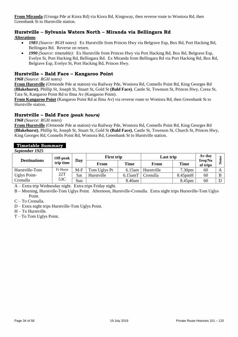
Page 34 of 58 19 July 2019 Private Route Histories 101 – 125
From Miranda (Urunga Pde at Kiora Rd) via Kiora Rd, Kingsway, then reverse route to Woniora Rd, then
Greenbank St to Hurstville station.
Hurstville – Sylvania Waters North – Miranda via Bellingara Rd Alterations
1983 (Source: RGH notes): Ex Hurstville from Princes Hwy via Belgrave Esp, Box Rd, Port Hacking Rd,
Bellingara Rd. Reverse on return.
1990 (Source: timetable): Ex Hurstville from Princes Hwy via Port Hacking Rd, Box Rd, Belgrave Esp,
Evelyn St, Port Hacking Rd, Bellingara Rd. Ex Miranda from Bellingara Rd via Port Hacking Rd, Box Rd,
Belgrave Esp, Evelyn St, Port Hacking Rd, Princes Hwy.
Hurstville – Bald Face – Kangaroo Point 1968 (Source: RGH notes)
From Hurstville (Ormonde Pde at station) via Railway Pde, Woniora Rd, Connells Point Rd, King Georges Rd
(Blakehurst), Phillip St, Joseph St, Stuart St, Gold St (Bald Face), Castle St, Townson St, Princes Hwy, Corea St,
Tara St, Kangaroo Point Rd to Ilma Av (Kangaroo Point).
From Kangaroo Point (Kangaroo Point Rd at Ilma Av) via reverse route to Woniora Rd, then Greenbank St to
Hurstville station.
Hurstville – Bald Face (peak hours) 1968 (Source: RGH notes)
From Hurstville (Ormonde Pde at station) via Railway Pde, Woniora Rd, Connells Point Rd, King Georges Rd
(Blakehurst), Phillip St, Joseph St, Stuart St, Gold St (Bald Face), Castle St, Townson St, Church St, Princes Hwy,
King Georges Rd, Connells Point Rd, Woniora Rd, Greenbank St to Hurstville station.
Timetable Summary September 1925
Destinations Off-peak
trip time Day
First trip Last trip Av day
freq/No
of trips No
tes
From Time From Time
Hurstville-Tom
Uglys Point-
Cronulla
Fr Hurst
22T
53C
M-F Tom Uglys Pt 6.15am Hurstville 7.30pm 60 A
Sat Hurstville 6.15amT Cronulla 8.45pmH 60 B
Sun 8.40am 8.45pm 60 D
A – Extra trip Wednesday night. Extra trips Friday night.
B – Morning, Hurstville-Tom Uglys Point. Afternoon, Hurstville-Cronulla. Extra night trips Hurstville-Tom Uglys
Point.
C – To Cronulla.
D – Extra night trips Hurstville-Tom Uglys Point.
H – To Hurstville.
T – To Tom Uglys Point.
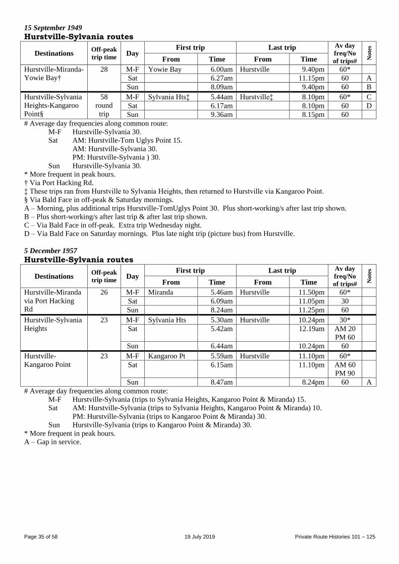
Page 35 of 58 19 July 2019 Private Route Histories 101 – 125
15 September 1949
Hurstville-Sylvania routes
Destinations Off-peak
trip time Day
First trip Last trip Av day
freq/No
of trips# No
tes
From Time From Time
Hurstville-Miranda-
Yowie Bay†
28 M-F Yowie Bay 6.00am Hurstville 9.40pm 60*
Sat 6.27am 11.15pm 60 A
Sun 8.09am 9.40pm 60 B
Hurstville-Sylvania
Heights-Kangaroo
Point§
58
round
trip
M-F Sylvania Hts‡ 5.44am Hurstville‡ 8.10pm 60* C
Sat 6.17am 8.10pm 60 D
Sun 9.36am 8.15pm 60
# Average day frequencies along common route:
M-F Hurstville-Sylvania 30.
Sat AM: Hurstville-Tom Uglys Point 15.
AM: Hurstville-Sylvania 30.
PM: Hurstville-Sylvania ) 30.
Sun Hurstville-Sylvania 30.
* More frequent in peak hours.
† Via Port Hacking Rd.
‡ These trips ran from Hurstville to Sylvania Heights, then returned to Hurstville via Kangaroo Point.
§ Via Bald Face in off-peak & Saturday mornings.
A – Morning, plus additional trips Hurstville-TomUglys Point 30. Plus short-working/s after last trip shown.
B – Plus short-working/s after last trip & after last trip shown.
C – Via Bald Face in off-peak. Extra trip Wednesday night.
D – Via Bald Face on Saturday mornings. Plus late night trip (picture bus) from Hurstville.
5 December 1957
Hurstville-Sylvania routes
Destinations Off-peak
trip time Day
First trip Last trip Av day
freq/No
of trips# No
tes
From Time From Time
Hurstville-Miranda
via Port Hacking
Rd
26 M-F Miranda 5.46am Hurstville 11.50pm 60*
Sat 6.09am 11.05pm 30
Sun 8.24am 11.25pm 60
Hurstville-Sylvania
Heights
23 M-F Sylvania Hts 5.30am Hurstville 10.24pm 30*
Sat 5.42am 12.19am AM 20
PM 60
Sun 6.44am 10.24pm 60
Hurstville-
Kangaroo Point
23 M-F Kangaroo Pt 5.59am Hurstville 11.10pm 60*
Sat 6.15am 11.10pm AM 60
PM 90
Sun 8.47am 8.24pm 60 A
# Average day frequencies along common route:
M-F Hurstville-Sylvania (trips to Sylvania Heights, Kangaroo Point & Miranda) 15.
Sat AM: Hurstville-Sylvania (trips to Sylvania Heights, Kangaroo Point & Miranda) 10.
PM: Hurstville-Sylvania (trips to Kangaroo Point & Miranda) 30.
Sun Hurstville-Sylvania (trips to Kangaroo Point & Miranda) 30.
* More frequent in peak hours.
A – Gap in service.
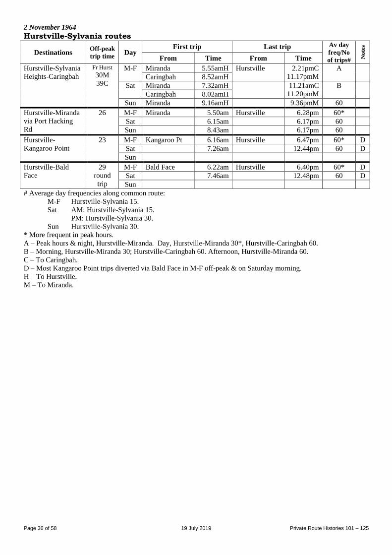
Page 36 of 58 19 July 2019 Private Route Histories 101 – 125
2 November 1964
Hurstville-Sylvania routes
Destinations Off-peak
trip time Day
First trip Last trip Av day
freq/No
of trips# No
tes
From Time From Time
Hurstville-Sylvania
Heights-Caringbah
Fr Hurst
30M
39C
M-F Miranda 5.55amH Hurstville 2.21pmC
11.17pmM
A
Caringbah 8.52amH
Sat Miranda 7.32amH 11.21amC
11.20pmM
B
Caringbah 8.02amH
Sun Miranda 9.16amH 9.36pmM 60
Hurstville-Miranda
via Port Hacking
Rd
26 M-F Miranda 5.50am Hurstville 6.28pm 60*
Sat 6.15am 6.17pm 60
Sun 8.43am 6.17pm 60
Hurstville-
Kangaroo Point
23 M-F Kangaroo Pt 6.16am Hurstville 6.47pm 60* D
Sat 7.26am 12.44pm 60 D
Sun
Hurstville-Bald
Face
29
round
trip
M-F Bald Face 6.22am Hurstville 6.40pm 60* D
Sat 7.46am 12.48pm 60 D
Sun
# Average day frequencies along common route:
M-F Hurstville-Sylvania 15.
Sat AM: Hurstville-Sylvania 15.
PM: Hurstville-Sylvania 30.
Sun Hurstville-Sylvania 30.
* More frequent in peak hours.
A – Peak hours & night, Hurstville-Miranda. Day, Hurstville-Miranda 30*, Hurstville-Caringbah 60.
B – Morning, Hurstville-Miranda 30; Hurstville-Caringbah 60. Afternoon, Hurstville-Miranda 60.
C – To Caringbah.
D – Most Kangaroo Point trips diverted via Bald Face in M-F off-peak & on Saturday morning.
H – To Hurstville.
M – To Miranda.
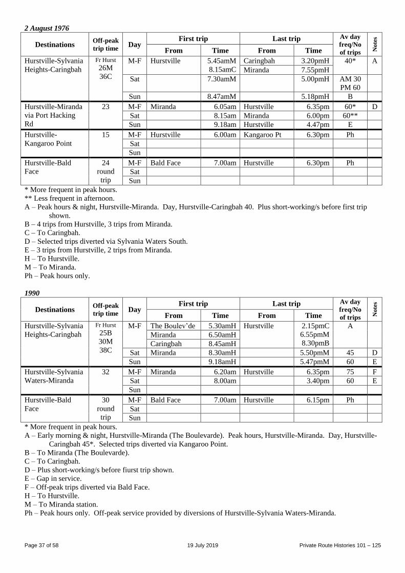
Page 37 of 58 19 July 2019 Private Route Histories 101 – 125
2 August 1976
Destinations Off-peak
trip time Day
First trip Last trip Av day
freq/No
of trips No
tes
From Time From Time
Hurstville-Sylvania
Heights-Caringbah
Fr Hurst
26M
36C
M-F Hurstville 5.45amM
8.15amC
Caringbah 3.20pmH 40* A
Miranda 7.55pmH
Sat 7.30amM 5.00pmH AM 30
PM 60
Sun 8.47amM 5.18pmH B
Hurstville-Miranda
via Port Hacking
Rd
23 M-F Miranda 6.05am Hurstville 6.35pm 60* D
Sat 8.15am Miranda 6.00pm 60**
Sun 9.18am Hurstville 4.47pm E
Hurstville-
Kangaroo Point
15 M-F Hurstville 6.00am Kangaroo Pt 6.30pm Ph
Sat
Sun
Hurstville-Bald
Face
24
round
trip
M-F Bald Face 7.00am Hurstville 6.30pm Ph
Sat
Sun
* More frequent in peak hours.
** Less frequent in afternoon.
A – Peak hours & night, Hurstville-Miranda. Day, Hurstville-Caringbah 40. Plus short-working/s before first trip
shown.
B – 4 trips from Hurstville, 3 trips from Miranda.
C – To Caringbah.
D – Selected trips diverted via Sylvania Waters South.
E – 3 trips from Hurstville, 2 trips from Miranda.
H – To Hurstville.
M – To Miranda.
Ph – Peak hours only.
1990
Destinations Off-peak
trip time Day
First trip Last trip Av day
freq/No
of trips No
tes
From Time From Time
Hurstville-Sylvania
Heights-Caringbah
Fr Hurst
25B
30M
38C
M-F The Boulev’de 5.30amH Hurstville 2.15pmC
6.55pmM
8.30pmB
A
Miranda 6.50amH
Caringbah 8.45amH
Sat Miranda 8.30amH 5.50pmM 45 D
Sun 9.18amH 5.47pmM 60 E
Hurstville-Sylvania
Waters-Miranda
32 M-F Miranda 6.20am Hurstville 6.35pm 75 F
Sat 8.00am 3.40pm 60 E
Sun
Hurstville-Bald
Face
30
round
trip
M-F Bald Face 7.00am Hurstville 6.15pm Ph
Sat
Sun
* More frequent in peak hours.
A – Early morning & night, Hurstville-Miranda (The Boulevarde). Peak hours, Hurstville-Miranda. Day, Hurstville-
Caringbah 45*. Selected trips diverted via Kangaroo Point.
B – To Miranda (The Boulevarde).
C – To Caringbah.
D – Plus short-working/s before fiurst trip shown.
E – Gap in service.
F – Off-peak trips diverted via Bald Face.
H – To Hurstville.
M – To Miranda station.
Ph – Peak hours only. Off-peak service provided by diversions of Hurstville-Sylvania Waters-Miranda.
Page 38 of 58 19 July 2019 Private Route Histories 101 – 125
Route 115
HURSTVILLE – MORTDALE – OATLEY HURSTVILLE – OATLEY (Waitara Pde) – OATLEY – OATLEY WEST
Extended from Hurstville to Brighton-le-Sands (weekends 1929-31)
(Waitara Pde, Oatley is in current Hurstville Grove.)
Timeline As at date of Govt Gazette 13 November 1925: Hurstville – Mortdale – Oatley being operated by:
Arthur Ashover
H Dale.
By date of Govt Gazette 17 December 1926: Altered to run Hurstville – Oatley (Waitara Pde).
By date of Govt Gazette 22 February 1929: Extended from Hurstville to Brighton-le-Sands on Saturday afternoons,
Sundays and Public Holidays.
1931: Brighton-le-Sands extension ceased as competitive under State Transport (Co-ordination) Act, leaving route as
Hurstville – Hurstville Grove.
1930-1: Transferred to Jack Iffland.
By 1941: Transferred to Red Transit Co (Roy H Carpenter, who had been Jack Iffland’s manager and related to the
Ifflands by marriage).
1957 or later: Red Transit Co transferred to Mrs Rodda.
1 July 1979: Transferred to Moore’s Tours (Trevor Moore).
By 20 February 1986: Extra route, Hurstville – Oatley commenced. Selected trips ran Hurstville – Hurstville Grove
– Oatley.
29 December 1987: Hurstville – Oatley extended from Oatley to Oatley West to replace part of Harris Park
Transport’s 146, which ceased at the same time.
By October 1988: Hurstville – Oatley – Oatley West trips renumbered 146, leaving 115 as Hurstville – Hurstville
Grove again. Selected trips provided by combined 115/146.
1 April 1996:
115, 146 & combined 115/146 renumbered 954 in the Sydney Region Route Number System (see Private
Route Histories - Contract Region 5).
Night and Sunday trips on AJ Moore’s 74/106 and Moore’s Tours’ 115, combined as 950, Hurstville –
Connells Point – Hurstville Grove – Oatley, in the Sydney Region Route Number System (see Private Route
Histories - Contract Region 5).
Streets
Hurstville – Mortdale – Oatley 1925 (Source: Govt Gazette of 13 November 1925) From Hurstville (Ormonde Pde at station) via Ormonde Pde, Railway Pde, Woniora Rd, Hillcrest Av, Landsdowne
St, Princes St, Grove St, Railway Pde (Mortdale), Morts Rd [now Coleborne Av], Judd St, Rosa St to Neville St
(Oatley).
From Oatley (Rosa St at Neville St) via reverse route to Woniora Rd, then Butlers Rd, Ormonde Pde to Hurstville
station.
Hurstville – Oatley (Waitara Pde) 1926 (Source: Govt Gazette of 17 December 1926)
From Hurstville (Ormonde Pde at station) via Ormonde Pde, Railway Pde, Woniora Rd, Hillcrest Av, Landsdowne
St, Waitara Pde to The Crescent (Oatley) [now Hurstville Grove].
From Oatley (Waitara Pde at The Crescent) via reverse route to Woniora Rd, then Butlers Rd, Ormonde Pde to
Hurstville station.
Hurstville – Oatley (Waitara Pde) (extended from Hurstville to Brighton-le-Sands on
weekends & Public Holidays) 1929 (Source: Govt Gazette of 22 February 1929) Brighton-le-Sands extension: Extended from Hurstville station via Ormonde Pde, Railway Pde, Elizabeth St,
Balfour St, Norman St, Augusta St [prior to realignment of Elizabeth St/Park Rd along Swanns Lane], Park Rd,
Kogarah Rd [now Princes Hwy], Rocky Point Rd, President Av, The Esplanade [now The Grand Pde] to Bay St
(Brighton-le-Sands). Return via The Grand Pde, Bay St, Trafalgar St, Duke St, The Grand Pde, then reverse route to
Hurstville.
Page 39 of 58 19 July 2019 Private Route Histories 101 – 125
Hurstville – Hurstville Grove Circa 1946 (Source: Gregory’s Street Directory)
From Hurstville (station) via Ormonde Pde, Butler Rd, Woniora Rd, Hillcrest Av, Lansdowne St, Waitara Pde
(Hurstville Grove).
Circa 1948 (Source: Gregory’s Street Directory)
From Hurstville (station) via Ormonde Pde, Railway Pde, Woniora Rd, Hillcrest Av, Lansdowne St, Waitara Pde
(Hurstville Grove).
1968 (Source: RGH notes)
From Hurstville (Ormonde Pde at station) via Ormonde Pde, Railway Pde, Woniora Rd, Hillcrest Av, Lansdowne St,
Waitara Pde to Whitfield Pde (Hurstville Grove).
From Hurstville Grove (Waitara Pde at Whitfield Pde) via Waitara Pde, Lansdowne St, Hillcrest Av, Woniora Rd,
Greenbank St, Ormonde Pde to Hurstville station.
Hurstville – Oatley 1986 (Source: timetable)
From Hurstville (Ormonde Pde at station) via Ormonde Pde, Railway Pde, Woniora Rd, Hillcrest Av, Hurstville Rd,
Rosa St, Wonoona Pde, Frederick St, Oatley Pde to Oatley station.
From Oatley (Oatley Pde at station) via reverse route to Hillcrest Av, then Woniora Rd, Greenbank St, Ormonde Pde
to Hurstville station.
Hurstville Grove diversion: Ex Hurstville from Hillcrest Av/Lansdowne St via Lansdowne St, Waitara Pde to
Whitfield Pde, then Waitara Pde, Lansdowne St to Hillcrest Av.
Timetable Summary September 1925
Destinations Off-peak
trip time Day
First trip Last trip Av day
freq/No
of trips No
tes
From Time From Time
Hurstville-Oatley
(Waitara Pde†)
20 M-F Waitara Pde 6.25am Hurstville 6.50pm 60 A
Sat 6.50am 7.16pm 60 B
Hurstville 9.15am Oatley 6.55pm
Sun Waitara Pde 6.40pm Hurstville 8.45pm 2 trips
† Shown in timetable as Landsdowne St.
A – Extra trip Thursday night. Extra trips Friday night.
B – Plus picture bus Saturday night.
October 1943
Destinations Off-peak
trip time Day
First trip Last trip Av day
freq/No
of trips No
tes
From Time From Time
Hurstville-
Hurstville Grove
Approx
10
M-F Hurstville Grv 6.07am Hurstville 11.41pm 60*
Sat 6.10am 11.57pm AM 30
PM 60
Sun 12.55pm 9.11pm 60
* More frequent in peak hours.
25 December 1966
Destinations Off-peak
trip time Day
First trip Last trip Av day
freq/No
of trips No
tes
From Time From Time
Hurstville-
Hurstville Grove
Approx
10
M-F Hurstville Grv 5.53am Hurstville 9.45pm 30*
Sat 6.00am 9.45pm AM 15
PM 30
Sun 8.55am 6.45pm 30
* More frequent in peak hours.
Page 40 of 58 19 July 2019 Private Route Histories 101 – 125
Circa 1995
Destinations Off-peak
trip time Day
First trip Last trip Av day
freq/No
of trips No
tes
From Time From Time
Hurstville-
Hurstville Grove
Approx
10
M-F Hurstville Grv 5.42am Hurstville 6.40pm 30* A
Sat 7.25am 6.15pm 30
Sun
* More frequent in peak hours.
A – Extra trips Thursday night. Includes combined 115/146 in inter-peak & afternoon peak hour.
Combined routes 115/146
HURSTVILLE – HURSTVILLE GROVE – OATLEY – OATLEY WEST
Timeline 10 October 1988: Selcted trips on 115 & 146 ran via a combined route (trips from Hurstville to Oatley station only,
trips to Hurstville from Oatley West). Operated by Moore’s Tours (Trevor Moore).
1 April 1996: Renumbered 954 in the Sydney Region Route Number System (see Private Route Histories - Contract
Region 10/11).
Streets From 10 October 1988 (Source: timetable)
From Hurstville (Ormonde Pde at station) via Railway Pde, Woniora Rd, Hillcrest Av, Lansdowne St, Waitara Pde to
Whitfield Pde (Hurstville Grove), then Waitara Pde, Lansdowne St, Hillcrest Av, Hurstville Rd, Rosa St, Frederick
St, Oatley Pde to Oatley station.
From Oatley West (Lansdowne Pde/Baker St) via (Lansdowne Pde loop?) Baker St, Douglas Haig Av, Short St,
Lloyd St, Gungah Bay Rd, Mulga St, railway underpass, (?), Hurstville Rd, then reverse route to Woniora Rd, then
Greenbank St, Ormonde Pde to Hurstville station.
Route 116
HURSTVILLE – DUMBLETON – LAKEMBA
(Dumbleton was renamed Beverly Hills in 1940.)
Timeline As at date of Govt Gazette 13 November 1925: Being operated by William S Hall.
By date of Govt Gazette 15 October 1926: Ceased. 34 was rerouted as Burwood – Lakemba – Hurstville at about
the same time as 116 ceased.
Streets 1925 (Source: Govt Gazette of 13 November 1925) From Hurstville (Railway Square at station) via Forest Rd, Belmore [now King Georges] Rd (Dumbleton [now
Beverly Hills], Canarys [now King Georges] Rd, Shorter Av, Penshurst Rd, Canarys Rd [part now King Georges Rd],
Canterbury Rd, Haldon St, Godfrey St [now The Boulevarde] to Haldon St (Lakemba). Reverse on return.
Timetable Summary September 1925
Destinations Off-peak
trip time Day
First trip Last trip Av day
freq/No
of trips No
tes
From Time From Time
Hurstville-Lakemba 28 M-F Lakemba 6.30am Hurstville 5.40pm 30-90 A
Sat 6.30am 4.17pm 30-90 B
Sun 9.25am 8.15pm 6 trips
A – Plus later trips from Hurstville to Shorter Av. Extra trips Wednesday night.
B – Plus later trips from Hurstville to Shorter Av.
Page 41 of 58 19 July 2019 Private Route Histories 101 – 125
Route 116
KOGARAH – RAMSGATE BEACH via Rocky Point Rd & Ramsgate Rd
Timeline Circa December 1928: Commenced by Thornton E Harrigan, as noted in Govt Gazette of 22 February 1929.
Probably late 1931: Ceased, as it probably would have been considered competitive with the Koragah-Sans Souci
steam tram line under State Transport (Co-ordination) Act.
Streets 1929 (Source: Govt Gazette of 22 February 1929) From Kogarah (Railway Pde at Montgomery St) via Railway Pde, Belgrave St, Kensington St, Queens Av, Ocean St,
Shaw St, Rocky Point Rd, Ramsgate Rd to Carruthers Dr [now The Grand Pde] (Ramsgate Beach). Reverse on return.
Timetable Summary December 1928
Destinations Off-peak
trip time Day
First trip Last trip Av day
freq/No
of trips No
tes
From Time From Time
Kogarah-Ramsgate
Beach
Approx
15
M-F Ramsgate Bch 6.15am Kogarah 9.45pm 40 A
Sat 7.50am 7.50pm AM 40
PM 60
A
Sun 8.20am 10.45pm 40
A – Plus picture bus Monday-Saturday.
Route 116
ALLAWAH – HURSTVILLE – OATLEY – OATLEY WEST
Timeline By early 1946: Hurstville – Oatley commenced by Roy H Carpenter.
January 1947: Transferred to HW Colson.
March 1947: Transferred to FA Wallis.
October 1951: Transferred to Sandy Beach Bus Co (AJ (Archie) Moore) (later part of the Harris Park Transport
group).
At or after transfer to Sandy Beach Bus Co:
Extended from Oatley to Oatley West (Lansdowne Pde)
Extended from Hurstville to Allawah (Illawarra St/Mona St)
Became a mainly off-peak & Saturday service.
After 146 was extended from Mortdale to Allawah, 116 worked in conjunction with 146, sharing Mortdale –
Hurstville – Allawah.
June 1957: Absorbed into 146.
Streets
Hurstville – Mortdale – Oatley Circa 1946 (Source: Gregory’s Street Directory)
From Hurstville (station) via Ormonde Pde, Butler Rd, Woniora Rd, Greenbank St, Belmore [now King Georges]
Rd, Penshurst Av, Laycock St, The Strand, The Broadway, Laycock St, Princes St, Coleborne Av to Mortdale station,
then return via Coleborne Av, Judd St, Hurstville Rd, Rosa St, Frederick St, Oatley Av, Oatley Pde (Oatley).
Circa 1948 (Source: Gregory’s Street Directory)
From Hurstville (station) via Ormonde Pde, Railway St, Woniora Rd, Greenbank St, Belmore [now King Georges]
Rd, Penshurst Av, Laycock St, The Strand, The Broadway, Laycock St, Princes St, Coleborne Av to Mortdale station,
then return via Coleborne Av, Judd St, Hurstville Rd, Rosa St, Frederick St, Oatley Av, Oatley Pde (Oatley).
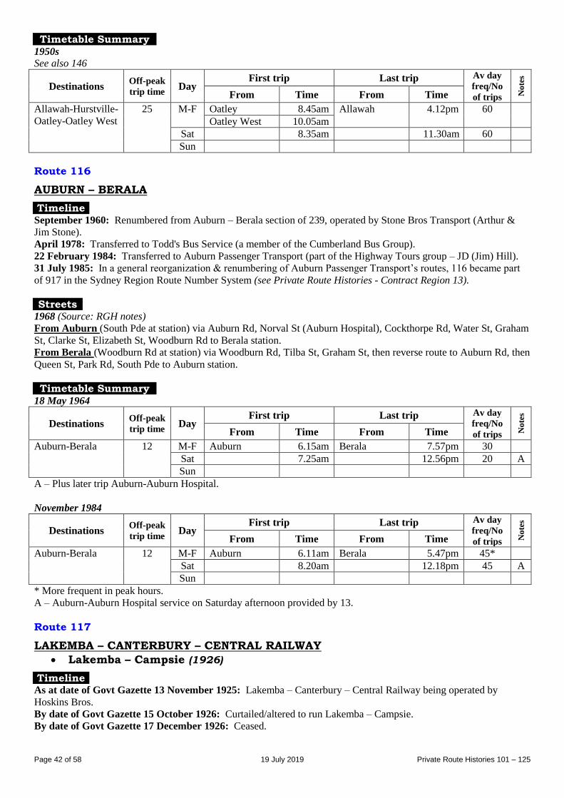
Page 42 of 58 19 July 2019 Private Route Histories 101 – 125
Timetable Summary 1950s
See also 146
Destinations Off-peak
trip time Day
First trip Last trip Av day
freq/No
of trips No
tes
From Time From Time
Allawah-Hurstville-
Oatley-Oatley West
25 M-F Oatley 8.45am Allawah 4.12pm 60
Oatley West 10.05am
Sat 8.35am 11.30am 60
Sun
Route 116
AUBURN – BERALA
Timeline September 1960: Renumbered from Auburn – Berala section of 239, operated by Stone Bros Transport (Arthur &
Jim Stone).
April 1978: Transferred to Todd's Bus Service (a member of the Cumberland Bus Group).
22 February 1984: Transferred to Auburn Passenger Transport (part of the Highway Tours group – JD (Jim) Hill).
31 July 1985: In a general reorganization & renumbering of Auburn Passenger Transport’s routes, 116 became part
of 917 in the Sydney Region Route Number System (see Private Route Histories - Contract Region 13).
Streets 1968 (Source: RGH notes)
From Auburn (South Pde at station) via Auburn Rd, Norval St (Auburn Hospital), Cockthorpe Rd, Water St, Graham
St, Clarke St, Elizabeth St, Woodburn Rd to Berala station.
From Berala (Woodburn Rd at station) via Woodburn Rd, Tilba St, Graham St, then reverse route to Auburn Rd, then
Queen St, Park Rd, South Pde to Auburn station.
Timetable Summary 18 May 1964
Destinations Off-peak
trip time Day
First trip Last trip Av day
freq/No
of trips No
tes
From Time From Time
Auburn-Berala 12 M-F Auburn 6.15am Berala 7.57pm 30
Sat 7.25am 12.56pm 20 A
Sun
A – Plus later trip Auburn-Auburn Hospital.
November 1984
Destinations Off-peak
trip time Day
First trip Last trip Av day
freq/No
of trips No
tes
From Time From Time
Auburn-Berala 12 M-F Auburn 6.11am Berala 5.47pm 45*
Sat 8.20am 12.18pm 45 A
Sun
* More frequent in peak hours.
A – Auburn-Auburn Hospital service on Saturday afternoon provided by 13.
Route 117
LAKEMBA – CANTERBURY – CENTRAL RAILWAY
Lakemba – Campsie (1926)
Timeline As at date of Govt Gazette 13 November 1925: Lakemba – Canterbury – Central Railway being operated by
Hoskins Bros.
By date of Govt Gazette 15 October 1926: Curtailed/altered to run Lakemba – Campsie.
By date of Govt Gazette 17 December 1926: Ceased.
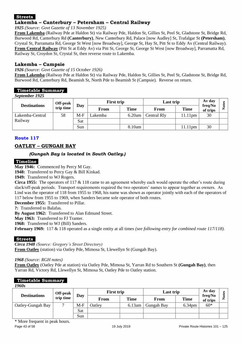
Page 43 of 58 19 July 2019 Private Route Histories 101 – 125
Streets
Lakemba – Canterbury – Petersham – Central Railway 1925 (Source: Govt Gazette of 13 November 1925) From Lakemba (Railway Pde at Haldon St) via Railway Pde, Haldon St, Gillies St, Peel St, Gladstone St, Bridge Rd,
Burwood Rd, Canterbury Rd (Canterbury), New Canterbury Rd, Palace [now Audley] St, Trafalgar St (Petersham),
Crystal St, Parramatta Rd, George St West [now Broadway], George St, Hay St, Pitt St to Eddy Av (Central Railway).
From Central Railway (Pitt St at Eddy Av) via Pitt St, George St, George St West [now Broadway], Parramatta Rd,
Railway St, Croydon St, Crystal St, then reverse route to Lakemba.
Lakemba – Campsie 1926 (Source: Govt Gazette of 15 October 1926) From Lakemba (Railway Pde at Haldon St) via Railway Pde, Haldon St, Gillies St, Peel St, Gladstone St, Bridge Rd,
Burwood Rd, Canterbury Rd, Beamish St, North Pde to Beamish St (Campsie). Reverse on return.
Timetable Summary September 1925
Destinations Off-peak
trip time Day
First trip Last trip Av day
freq/No
of trips No
tes
From Time From Time
Lakemba-Central
Railway
58 M-F Lakemba 6.20am Central Rly 11.11pm 30 Sat Sun 8.10am 11.11pm 30
Route 117
OATLEY – GUNGAH BAY
(Gungah Bay is located in South Oatley.)
Timeline May 1946: Commenced by Percy M Gay.
1948: Transferred to Percy Gay & Bill Kinkad.
1949: Transferred to WJ Rogers.
Circa 1955: The operators of 117 & 118 came to an agreement whereby each would operate the other’s route during
slack/off-peak periods. Transport requirements required the two operators’ names to appear together as owners. As
Lind was the operator of 118 from 1955 to 1968, his name was shown as operator jointly with each of the operators of
117 below from 1955 to 1969, when Sanders became sole operator of both routes.
December 1955: Transferred to Pillar.
?: Transferred to Balafas.
By August 1962: Transferred to Alan Edmund Street.
May 1963: Transferred to FJ Tranter.
1968: Transferred to WJ (Bill) Sanders.
February 1969: 117 & 118 operated as a single entity at all times (see following entry for combined route 117/118).
Streets Circa 1948 (Source: Gregory’s Street Directory)
From Oatley (station) via Oatley Pde, Mimosa St, Llewellyn St (Gungah Bay).
1968 (Source: RGH notes)
From Oatley (Oatley Pde at station) via Oatley Pde, Mimosa St, Yarran Rd to Southern St (Gungah Bay), then
Yarran Rd, Victory Rd, Llewellyn St, Mimosa St, Oatley Pde to Oatley station.
Timetable Summary 1960s
Destinations Off-peak
trip time Day
First trip Last trip Av day
freq/No
of trips No
tes
From Time From Time
Oatley-Gungah Bay 7 M-F Oatley 6.13am Gungah Bay 6.34pm 60*
Sat
Sun
* More frequent in peak hours.
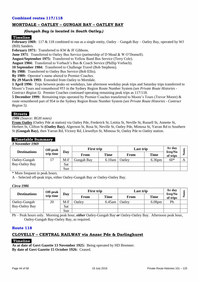
Page 44 of 58 19 July 2019 Private Route Histories 101 – 125
Combined routes 117/118
MORTDALE – OATLEY – GUNGAH BAY – OATLEY BAY
(Gungah Bay is located in South Oatley.)
Timeline February 1969: 117 & 118 combined to run as a single entity, Oatley – Gungah Bay – Oatley Bay, operated by WJ
(Bill) Sanders.
February 1971: Transferred to KW & JF Gibbons.
June 1971: Transferred to Oatley Bus Service (partnership of D Mead & W O’Donnell).
August/September 1975: Transferred to Yellow Band Bus Service (Terry Cole).
August 1984: Transferred to Vorbach’s Bus & Coach Service (Phillip Vorbach).
10 September 1984: Transferred to Challenge Travel (Bob Stephens).
By 1988: Transferred to Oatley Bus Service (Bob Ellis).
By 1989: Operator’s name altered to Premier Coaches.
By 29 March 1993: Extended from Oatley to Mortdale.
1 April 1996: Trips between peaks on weekdays, late afternoon weekday peak trips and Saturday trips transferred to
Moore’s Tours and renumbered 953 in the Sydney Region Route Number System (see Private Route Histories -
Contract Region 5). Premier Coaches continued operating remaining peak trips as 117/118.
5 December 1999: Remaining trips operated by Premier Coaches transferred to Moore’s Tours (Trevor Moore) &
route renumbered part of 954 in the Sydney Region Route Number System (see Private Route Histories - Contract
Region 5).
Streets 1986 (Source: RGH notes)
From Oatley (Oatley Pde at station) via Oatley Pde, Frederick St, Letitia St, Neville St, Russell St, Annette St,
Herbert St, Clifton St (Oatley Bay), Algernon St, Rosa St, Neville St, Oatley Pde, Mimosa St, Yarran Rd to Southern
St (Gungah Bay), then Yarran Rd, Victory Rd, Llewellyn St, Mimosa St, Oatley Pde to Oatley station.
Timetable Summary 3 November 1969
Destinations Off-peak
trip time Day
First trip Last trip Av day
freq/No
of trips No
tes
From Time From Time
Oatley-Gungah
Bay-Oatley Bay
17 M-F Gungah Bay 6.10am Oatley 6.36pm 60* A
Sat
Sun
* More frequent in peak hours.
A – Selected off-peak trips, either Oatley-Gungah Bay or Oatley-Oatley Bay.
Circa 1986
Destinations Off-peak
trip time Day
First trip Last trip Av day
freq/No
of trips No
tes
From Time From Time
Oatley-Gungah
Bay-Oatley Bay
20 M-F Oatley 6.45am Oatley 6.08pm Ph
Sat
Sun
Ph – Peak hours only. Morning peak hour, either Oatley-Gungah Bay or Oatley-Oatley Bay. Afternoon peak hour,
Oatley-Gungah Bay-Oatley Bay, as required.
Route 118
CLOVELLY – CENTRAL RAILWAY via Anzac Pde & Darlinghurst
Timeline As at date of Govt Gazette 13 November 1925: Being operated by HD Bremner.
By date of Govt Gazette 15 October 1926: Ceased.
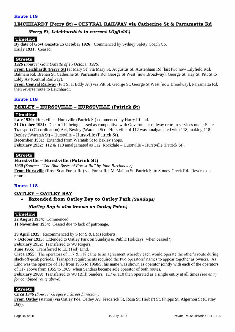
Page 45 of 58 19 July 2019 Private Route Histories 101 – 125
Route 118
LEICHHARDT (Perry St) – CENTRAL RAILWAY via Catherine St & Parramatta Rd
(Perry St, Leichhardt is in current Lilyfield.)
Timeline By date of Govt Gazette 15 October 1926: Commenced by Sydney Safety Coach Co.
Early 1931: Ceased.
Streets 1926 (Source: Govt Gazette of 15 October 1926) From Leichhardt (Perry St) (at Mary St) via Mary St, Augustus St, Austenham Rd [last two now Lilyfield Rd],
Balmain Rd, Brenan St, Catherine St, Parramatta Rd, George St West [now Broadway], George St, Hay St, Pitt St to
Eddy Av (Central Railway).
From Central Railway (Pitt St at Eddy Av) via Pitt St, George St, George St West [now Broadway], Parramatta Rd,
then reverse route to Leichhardt.
Route 118
BEXLEY – HURSTVILLE – HURSTVILLE (Patrick St)
Timeline Late 1930: Hurstville – Hurstville (Patrick St) commenced by Harry Iffland.
31 October 1931: Due to 112 being classed as competitive with Government railway or tram services under State
Transport (Co-ordination) Act, Bexley (Waratah St) – Hurstville of 112 was amalgamated with 118, making 118
Bexley (Waratah St) – Hurstville – Hurstville (Patrick St). December 1931: Extended from Waratah St to Bexley shops.
February 1932: 112 & 118 amalgamated as 112, Rockdale – Hurstville – Hurstville (Patrick St).
Streets
Hurstville – Hurstville (Patrick St) 1930 (Source: “The Blue Buses of Forest Rd” by John Birchmeier)
From Hurstville (Rose St at Forest Rd) via Forest Rd, McMahon St, Patrick St to Stoney Creek Rd. Reverse on
return.
Route 118
OATLEY – OATLEY BAY Extended from Oatley Bay to Oatley Park (Sundays)
(Oatley Bay is also known as Oatley Point.)
Timeline 22 August 1934: Commenced.
11 November 1934: Ceased due to lack of patronage.
29 April 1935: Recommenced by S (or S & LM) Roberts.
7 October 1935: Extended to Oatley Park on Sundays & Public Holidays (when ceased?).
February 1952: Transferred to WJ Rogers.
June 1955: Transferred to EE (Ted) Lind.
Circa 1955: The operators of 117 & 118 came to an agreement whereby each would operate the other’s route during
slack/off-peak periods. Transport requirements required the two operators’ names to appear together as owners. As
Lind was the operator of 118 from 1955 to 1968/9, his name was shown as operator jointly with each of the operators
of 117 above from 1955 to 1969, when Sanders became sole operator of both routes.
February 1969: Transferred to WJ (Bill) Sanders. 117 & 118 then operated as a single entity at all times (see entry
for combined route above).
Streets Circa 1946 (Source: Gregory’s Street Directory)
From Oatley (station) via Oatley Pde, Oatley Av, Frederick St, Rosa St, Herbert St, Phipps St, Algernon St (Oatley
Bay).
Page 46 of 58 19 July 2019 Private Route Histories 101 – 125
1968 (Source: RGH notes)
From Oatley (Oatley Pde at station) via Oatley Pde, Frederick St, Rosa St, Neville St, Annette St, Herbert St, Clifton
St (Oatley Bay), Algernon St, Rosa St, Neville St, Letitia St, Frederick St, Oatley Pde to Oatley station.
Timetable Summary 1960s
Destinations Off-peak
trip time Day
First trip Last trip Av day
freq/No
of trips No
tes
From Time From Time
Oatley-Oatley Bay M-F Oatley Bay 6.14am Oatley 6.30pm 60*
Sat
Sun
* More frequent in peak hours.
Route 119
LEICHHARDT – SOUTH ANNANDALE – NEWTOWN BRIDGE
Post 31 October 1931 feeder (& later extensions): NEWTOWN BRIDGE –
WHITE BAY via Johnston St
Extended from White Bay to Lilyfield (Sundays, 1940s)
Timeline As at date of Govt Gazette 13 November 1925: Leichhardt – Newtown being operated by T Brien or Brien & Brien
(?).
Latter half of 1930: Transferred to Rozelle-Newtown Bus Co (a group of Brien’s employees).
31 October 1931: Declared as partly competitive with trams under State Transport (Co-ordination) Act.
1931/2: Restored as a feeder, Newtown – Johnston St, Annandale.
1932/3: Extended from Johnston St, Annandale to Rozelle Bay.
16 August 1933: Extended from Rozelle Bay to White Bay (Barnes St/Commercial Rd [now Victoria Rd/The
Crescent]).
15 September 1938: Transferred to WJ Brien, by 1941 trading as Briens Bus Service. By 1960s, Charlie Westwood
was manager. (A list dated October 1935 shows the operator as WJ Brien.)
By 1944: Sunday & Public Holiday service extended from White Bay to Lilyfield.
1950 or after: Sunday & Public Holiday extension from White Bay to Lilyfield ceased.
1 August 1987: Transferred to ABC Coach Lines (incorporating Briens Bus Service) (Peter Brewer & Charlie
Westwood).
16 November 1987: Extended from Newtown to Marrickville Metro (shopping centre) upon its opening and
renumbered into the Sydney Region Route Number System (see Private Route Histories - Routes transferred to State
Transit Authority):
451 Marrickville Metro – White Bay
452 Marrickville Metro – Annandale (Pritchard St, short diversion of 451).
Streets
Newtown Bridge – Leichhardt 1925 (Source: Govt Gazette of 13 November 1925) From Newtown Bridge (Australia St at King St) via Australia St, Salisbury Rd, Bridge Rd, Parramatta Rd, Renwick
St, Marion St to Norton St (Leichhardt). Reverse on return.
Newtown Bridge – White Bay – Lilyfield Circa 1946 (Source: Gregory’s Street Directory)
From Newtown Bridge via Australia St, Salisbury Rd, Bridge Rd, Parramatta Rd, Johnston St (Annandale), The
Crescent, Commercial Rd [now The Crescent], Victoria Rd (White Bay), Storey St [now Lilyfield Rd], Burt St,
Denison St, Storey St [now Lilyfield Rd], New Abattoirs Rd, Austenham Rd, Augustus St [last three now part of
Lilyfield Rd] to Norton St (Lilyfield).
Newtown Bridge – White Bay 1968 (Source: RGH notes)
From Newtown Bridge (Australia St at Bedford St) via Australia St, Salisbury Rd, Bridge Rd, Parramatta Rd,
Johnston St (Annandale), The Crescent, Commercial Rd, Victoria Rd, Robert St to Mullens St (White Bay).
Page 47 of 58 19 July 2019 Private Route Histories 101 – 125
From White Bay (Robert St at Mullens St) via reverse route to Australia St, then Lennox St, Denison St, Bedford St,
Australia St to Bedford St (Newtown).
Alteration
1986 (Source: RGH notes): Extended in White Bay from Robert St/Mullens St via Robert St to Buchanan St.
Reverse on return.
Timetable Summary September 1925
Destinations Off-peak
trip time Day
First trip Last trip Av day
freq/No
of trips No
tes
From Time From Time
Newtown Bridge-
Leichhardt
14 M-F Leichhardt 6.30am Newtown 10.35pm 20
Sat 6.30am 10.35pm 20-30
Sun
1944-1950s period
Destinations Off-peak
trip time Day
First trip Last trip Av day
freq/No
of trips No
tes
From Time From Time
Newtown Bridge-
White Bay†
M-F White Bay 6.40am Newtown 11.20pm 20
Sat 6.40am 11.20pm 20
Sun Lilyfield 10.00am 10.30pm AM 60
PM 30
† Extended to Lilyfield (referred to in timetable as Leichhardt) on Sundays & Public Holidays.
March 1983
Destinations Off-peak
trip time Day
First trip Last trip Av day
freq/No
of trips No
tes
From Time From Time
Newtown Bridge-
White Bay
20 M-F White Bay 6.40am Newtown 6.20pm 40*
Sat 6.40am 2.00pm 40
Sun
* More frequent in peak hours.
Route 120
LEICHHARDT (various termini) – CITY (York St) via Pyrmont Bridge
Post 31 October 1931 feeder: ASHFIELD – LEICHHARDT
Timeline As at date of Govt Gazette 13 November 1925: Leichhardt (Marion St) –City (York St) being operated by Angus
Chisholm.
By date of Govt Gazette 27 May 1927: Extended from Marion St to Allen & Flood Sts, Leichhardt.
31 October 1931: Ceased as competitive with trams under State Transport (Co-ordination) Act.
1932: Recommenced as a feeder, Leichhardt – Ashfield, operator unknown.
31 May 1933: Ceased due to lack of patronage.
Streets
Leichhardt (Marion St) – City (York St) 1925 (Source: Govt Gazette of 13 November 1925 From Leichhardt (Marion St) (at Norton St) via Marion St, Renwick St, Parramatta Rd, Pyrmont Bridge Rd,
Pyrmont Bridge, Market St, York St to near Market St (City).
From City (York St) (at Market St) via York St, Druitt St, Clarence St, Market St, then reverse route to Leichhardt.
Leichhardt (Allen St) – City (York St) Alteration
1927 (Source: Govt Gazette of 27 May 1927): Extended in Leichhardt from Marion St/Renwick St via Marion St,
Cromwell St, Allen St to Flood St. Reverse on return.
Page 48 of 58 19 July 2019 Private Route Histories 101 – 125
Timetable Summary September 1925
Destinations Off-peak
trip time Day
First trip Last trip Av day
freq/No
of trips No
tes
From Time From Time
Leichhardt (Marion
St)-City (York St)
M-F Marion St 6.55am York St 6.10pm 60 A
Sat 6.55am 1.05pm 60-90
Sun
A – Extra trips Friday night.
Route 120
ENMORE – STANMORE – LILYFIELD – ROZELLE (Alfred St)
Timeline 30 March 1937: Stanmore – Lilyfield commenced by Tom Brien.
26 July 1937: Extended from Stanmore to Enmore.
March 1953: Transferred to Spencer Lowe.
August 1955: Transferred to Roy A Berglund.
July 1957: Extended from Lilyfield to Rozelle (Alfred St).
May 1963: Transferred to Arthur L Appleby & RD (Ray) Nelson (later trading as Tempe Bus Service).
6 December 1965: 120, 129 & 227 amalgamated as 129 Rockdale – Enmore – Lilyfield – Rozelle (Alfred St).
Streets
Enmore – Lilyfield Circa 1946 (Source: Gregory’s Street Directory)
From Enmore (tram terminus [Stanmore Rd/Enmore Rd]) via Stanmore Rd, Liberty St, Railway Av, Douglas St
(Stanmore), Percival Rd, Parramatta Rd, Catherine St to Brenan St (Lilyfield).
Circa 1956 (Source: timetable)
Lilyfield terminus in Justin St [timetable claims Justin St was in Rozelle, but street directories show it in Lilyfield].
Timetable Summary Circa 1956
Destinations Off-peak
trip time Day
First trip Last trip Av day
freq/No
of trips No
tes
From Time From Time
Enmore-Lilyfield 20 M-F Enmore 6.00am Lilyfield 7.30pm 20
Sat 6.30am Enmore 7.30pm AM 20
PM 40
Sun
Route 121
LEICHHARDT (William St) – CENTRAL RAILWAY via Parramatta Rd
Timeline As at date of Govt Gazette 13 November 1925: Being operated by Sydney Safety Coaches and/or Mrs Meyer (?).
By date of Govt Gazette 27 May 1927: Ceased.
Streets 1925 (Source: Govt Gazette of 13 November 1925
From Leichhardt (William St) (at Elswick St) via William St, Flood St, Allen St, Cromwell St, Marion St,
Renwick St, Parramatta Rd, George St West [now Broadway], George St, Hay St, Pitt St to Eddy Av (Central
Railway).
From Central Railway (Pitt St at Eddy Av) via Pitt St, George St, George St West [now Broadway], Parramatta Rd,
then reverse route to Leichhardt.
Page 49 of 58 19 July 2019 Private Route Histories 101 – 125
Timetable Summary September 1925
Destinations Off-peak
trip time Day
First trip Last trip Av day
freq/No
of trips No
tes
From Time From Time
Leichhardt
(William St)-
Central Railway
24 M-F Leichhardt 6.39am Central Rly 11.52pm 15-30 A
Sat 6.39am 11.52pm 15-30 A
Sun 1.24pm 12.52am 30
A – Extra trips Friday & Saturday night.
Route 121
KOGARAH – CARSS PARK Extended from Carss Park to Bald Face (1952-63)
Timeline Late 1920s: Kogarah – Carss Park via Carwar Av commenced.
By October 1935: Being operated by AG Harrigan.
By the late 1930s: Transferred to D Scott.
August 1943: Transferred to Kogarah Bus Service (Brian W LeQuesne).
28 May 1952: Amalgamated with 195 & extended as 121, Kogarah – Carss Park – Bald Face, following completion
of connecting bridge over drain in Carss Park, as part of a general reorganisation of Kogarah Bus Service’s 64, 121 &
195. The extension partly replaced 64, which ceased at the same time.
By September 1963: Curtailed to run Kogarah – Kogarah Bay – Carss Park (loop around Kogarah Bay/Carss Park
operated anti-clockwise till about 11am, then clockwise). Service to Bald Face then entirely provided by diversion of
114 from Hurstville (114 had provided a Hurstville – Bald Face service since 31 July 1961).
1970s(?): Kogarah Bus Service transferred to Keith Dodd.
May 1978: Kogarah Bus Service transferred to LW (Len) Reynolds.
June 1989: Transferred to EH Blythe (Neville Blythe), also trading as Kogarah-Carss Park Bus Service.
2 April 1994: Transferred to Southtrans (Ron Deane).
26 September 1994: Amalgamated with 958, Hurstville – Carss Park, as 958 Hurstville – Carss Park – Kogarah, in
the Sydney Region Route Number System (see Private Route Histories - Contract Region 10/11).
Streets
Kogarah – Carss Park Circa 1946 (Source: Gregory’s Street Directory)
From Kogarah (station) via Railway Pde, Bowns Rd, Princes Hwy, Carwar Av (Carss Park).
Kogarah – Carss Park – Bald Face Circa 1962 (Source: Collins Street Directory)
From Kogarah (Railway Pde at station) via Railway Pde, Bowns Rd, Princes Hwy, Park Rd, Wyee St, Wharf Rd,
Carlton Cr (Carss Park), Carwar Av, Princes Hwy (Blakehurst), Stuart St, Gold St (Bald Face), Castle St, Townson
St, Church St, Princes Hwy, Carwar Av, then reverse route to Kogarah station.
Trips direct via Princes Hwy: Via Princes Hwy direct between Park Rd & Carwar Av.
Kogarah – Carss Park – Kogarah Bay 1968 (Source: RGH notes/timetable)
Mornings From Kogarah (Railway Pde at station) via Railway Pde, Bowns Rd, Princes Hwy, Carwar Av, Carlton Cr (Carss
Park), Wharf Rd, Wyee St (Kogarah Bay), Park Rd, Princes Hwy, Bowns Rd, Railway Pde to Kogarah station.
Afternoons From Kogarah (Railway Pde at station) via Railway Pde, Bowns Rd, Princes Hwy, Park Rd, Wyee St (Kogarah
Bay), Wharf Rd, Carlton Cr (Carss Park), Carwar Av, Princes Hwy, Bowns Rd, Railway Pde to Kogarah station.
Alteration
1986 (Source: RGH notes): To approach Kogarah from Railway Pde via Regent St, Gladstone St, Railway Pde to
Regent St.
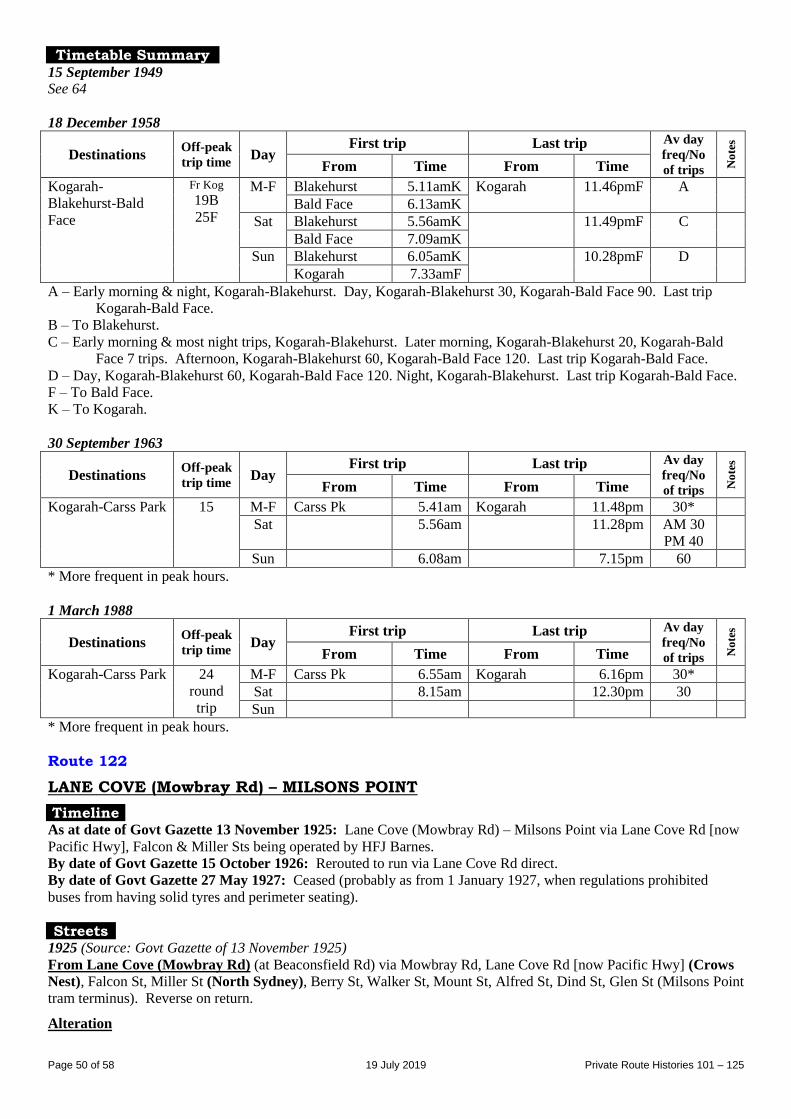
Page 50 of 58 19 July 2019 Private Route Histories 101 – 125
Timetable Summary 15 September 1949
See 64
18 December 1958
Destinations Off-peak
trip time Day
First trip Last trip Av day
freq/No
of trips No
tes
From Time From Time
Kogarah-
Blakehurst-Bald
Face
Fr Kog
19B
25F
M-F Blakehurst 5.11amK Kogarah 11.46pmF A
Bald Face 6.13amK
Sat Blakehurst 5.56amK 11.49pmF C
Bald Face 7.09amK
Sun Blakehurst 6.05amK 10.28pmF D
Kogarah 7.33amF
A – Early morning & night, Kogarah-Blakehurst. Day, Kogarah-Blakehurst 30, Kogarah-Bald Face 90. Last trip
Kogarah-Bald Face.
B – To Blakehurst.
C – Early morning & most night trips, Kogarah-Blakehurst. Later morning, Kogarah-Blakehurst 20, Kogarah-Bald
Face 7 trips. Afternoon, Kogarah-Blakehurst 60, Kogarah-Bald Face 120. Last trip Kogarah-Bald Face.
D – Day, Kogarah-Blakehurst 60, Kogarah-Bald Face 120. Night, Kogarah-Blakehurst. Last trip Kogarah-Bald Face.
F – To Bald Face.
K – To Kogarah.
30 September 1963
Destinations Off-peak
trip time Day
First trip Last trip Av day
freq/No
of trips No
tes
From Time From Time
Kogarah-Carss Park 15 M-F Carss Pk 5.41am Kogarah 11.48pm 30*
Sat 5.56am 11.28pm AM 30
PM 40
Sun 6.08am 7.15pm 60
* More frequent in peak hours.
1 March 1988
Destinations Off-peak
trip time Day
First trip Last trip Av day
freq/No
of trips No
tes
From Time From Time
Kogarah-Carss Park 24
round
trip
M-F Carss Pk 6.55am Kogarah 6.16pm 30*
Sat 8.15am 12.30pm 30
Sun
* More frequent in peak hours.
Route 122
LANE COVE (Mowbray Rd) – MILSONS POINT
Timeline As at date of Govt Gazette 13 November 1925: Lane Cove (Mowbray Rd) – Milsons Point via Lane Cove Rd [now
Pacific Hwy], Falcon & Miller Sts being operated by HFJ Barnes.
By date of Govt Gazette 15 October 1926: Rerouted to run via Lane Cove Rd direct.
By date of Govt Gazette 27 May 1927: Ceased (probably as from 1 January 1927, when regulations prohibited
buses from having solid tyres and perimeter seating).
Streets 1925 (Source: Govt Gazette of 13 November 1925) From Lane Cove (Mowbray Rd) (at Beaconsfield Rd) via Mowbray Rd, Lane Cove Rd [now Pacific Hwy] (Crows
Nest), Falcon St, Miller St (North Sydney), Berry St, Walker St, Mount St, Alfred St, Dind St, Glen St (Milsons Point
tram terminus). Reverse on return.
Alteration
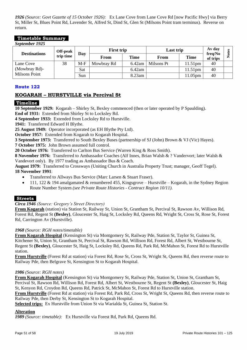
Page 51 of 58 19 July 2019 Private Route Histories 101 – 125
1926 (Source: Govt Gazette of 15 October 1926): Ex Lane Cove from Lane Cove Rd [now Pacific Hwy] via Berry
St, Miller St, Blues Point Rd, Lavender St, Alfred St, Dind St, Glen St (Milsons Point tram terminus). Reverse on
return.
Timetable Summary September 1925
Destinations Off-peak
trip time Day
First trip Last trip Av day
freq/No
of trips No
tes
From Time From Time
Lane Cove
(Mowbray Rd)-
Milsons Point
38 M-F Mowbray Rd 6.42am Milsons Pt 11.51pm 40 Sat 6.42am 11.51pm 40 Sun 8.23am 11.05pm 40
Route 122
KOGARAH – HURSTVILLE via Percival St
Timeline 10 September 1929: Kogarah – Shirley St, Bexley commenced (then or later operated by P Spaulding).
End of 1931: Extended from Shirley St to Locksley Rd.
4 September 1933: Extended from Locksley Rd to Hurstville.
1941: Transferred Edward H Blythe.
25 August 1949: Operator incorporated (as EH Blythe Pty Ltd).
October 1957: Extended from Kogarah to Kogarah Hospital.
3 September 1973: Transferred to South Bexley Buses (partnership of SJ (John) Brown & VJ (Vic) Hayes).
7 October 1975: John Brown assumed full control.
20 October 1976: Transferred to Carlton Bus Service (Warren King & Ross Smith).
8 November 1976: Transferred to Ambassador Coaches (Alf Innes, Brian Walsh & ? Vandervort; later Walsh &
Vandevort only). By 1977 trading as Ambassador Bus & Coach.
August 1979: Transferred to Crossways (Uniting Church in Australia Property Trust; manager, Geoff Tegel).
18 November 1991:
Transferred to Allways Bus Service (Marc Larsen & Stuart Fraser).
111, 122 & 194 amalgamated & renumbered 455, Kingsgrove – Hurstville – Kogarah, in the Sydney Region
Route Number System (see Private Route Histories - Contract Region 10/11).
Streets Circa 1946 (Source: Gregory’s Street Directory)
From Kogarah (station) via Station St, Railway St, Union St, Grantham St, Percival St, Rawson Av, Willison Rd,
Forest Rd, Regent St (Bexley), Gloucester St, Haig St, Locksley Rd, Queens Rd, Wright St, Cross St, Rose St, Forest
Rd, Carrington Av (Hurstville).
1968 (Source: RGH notes/timetable)
From Kogarah Hospital (Kensington St) via Montgomery St, Railway Pde, Station St, Taylor St, Guinea St,
Kitchener St, Union St, Grantham St, Percival St, Rawson Rd, Willison Rd, Forest Rd, Albert St, Westbourne St,
Regent St (Bexley), Gloucester St, Haig St, Locksley Rd, Queens Rd, Park Rd, McMahon St, Forest Rd to Hurstville
station.
From Hurstville (Forest Rd at station) via Forest Rd, Rose St, Cross St, Wright St, Queens Rd, then reverse route to
Railway Pde, then Belgrave St, Kensington St to Kogarah Hospital.
1986 (Source: RGH notes)
From Kogarah Hospital (Kensington St) via Montgomery St, Railway Pde, Station St, Union St, Grantham St,
Percival St, Rawson Rd, Willison Rd, Forest Rd, Albert St, Westbourne St, Regent St (Bexley), Gloucester St, Haig
St, Kenyon Rd, Croydon Rd, Queens Rd, Patrick St, McMahon St, Forest Rd to Hurstville station.
From Hurstville (Forest Rd at station) via Forest Rd, Park Rd, Cross St, Wright St, Queens Rd, then reverse route to
Railway Pde, then Derby St, Kensington St to Kogarah Hospital.
Selected trips: Ex Hurstville from Union St via Warialda St, Guinea St, Station St.
Alteration
1989 (Source: timetable): Ex Hurstville via Forest Rd, Park Rd, Queens Rd.
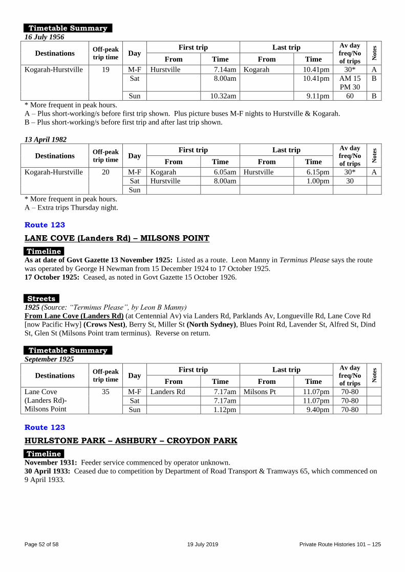
Page 52 of 58 19 July 2019 Private Route Histories 101 – 125
Timetable Summary 16 July 1956
Destinations Off-peak
trip time Day
First trip Last trip Av day
freq/No
of trips No
tes
From Time From Time
Kogarah-Hurstville 19 M-F Hurstville 7.14am Kogarah 10.41pm 30* A
Sat 8.00am 10.41pm AM 15
PM 30
B
Sun 10.32am 9.11pm 60 B
* More frequent in peak hours.
A – Plus short-working/s before first trip shown. Plus picture buses M-F nights to Hurstville & Kogarah.
B – Plus short-working/s before first trip and after last trip shown.
13 April 1982
Destinations Off-peak
trip time Day
First trip Last trip Av day
freq/No
of trips No
tes
From Time From Time
Kogarah-Hurstville 20 M-F Kogarah 6.05am Hurstville 6.15pm 30* A
Sat Hurstville 8.00am 1.00pm 30
Sun
* More frequent in peak hours.
A – Extra trips Thursday night.
Route 123
LANE COVE (Landers Rd) – MILSONS POINT
Timeline As at date of Govt Gazette 13 November 1925: Listed as a route. Leon Manny in Terminus Please says the route
was operated by George H Newman from 15 December 1924 to 17 October 1925.
17 October 1925: Ceased, as noted in Govt Gazette 15 October 1926.
Streets 1925 (Source: “Terminus Please”, by Leon B Manny) From Lane Cove (Landers Rd) (at Centennial Av) via Landers Rd, Parklands Av, Longueville Rd, Lane Cove Rd
[now Pacific Hwy] (Crows Nest), Berry St, Miller St (North Sydney), Blues Point Rd, Lavender St, Alfred St, Dind
St, Glen St (Milsons Point tram terminus). Reverse on return.
Timetable Summary September 1925
Destinations Off-peak
trip time Day
First trip Last trip Av day
freq/No
of trips No
tes
From Time From Time
Lane Cove
(Landers Rd)-
Milsons Point
35 M-F Landers Rd 7.17am Milsons Pt 11.07pm 70-80
Sat 7.17am 11.07pm 70-80
Sun 1.12pm 9.40pm 70-80
Route 123
HURLSTONE PARK – ASHBURY – CROYDON PARK
Timeline November 1931: Feeder service commenced by operator unknown.
30 April 1933: Ceased due to competition by Department of Road Transport & Tramways 65, which commenced on
9 April 1933.
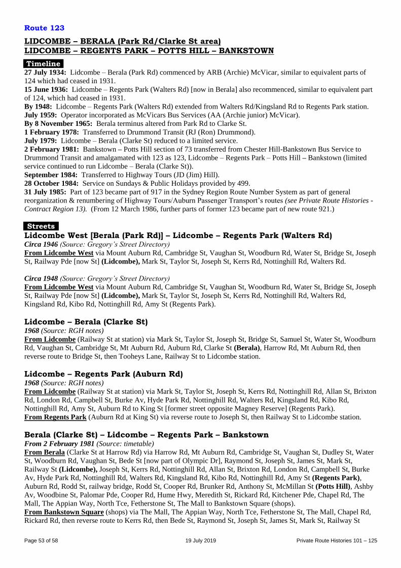
Page 53 of 58 19 July 2019 Private Route Histories 101 – 125
Route 123
LIDCOMBE – BERALA (Park Rd/Clarke St area) LIDCOMBE – REGENTS PARK – POTTS HILL – BANKSTOWN
Timeline 27 July 1934: Lidcombe – Berala (Park Rd) commenced by ARB (Archie) McVicar, similar to equivalent parts of
124 which had ceased in 1931.
15 June 1936: Lidcombe – Regents Park (Walters Rd) [now in Berala] also recommenced, similar to equivalent part
of 124, which had ceased in 1931.
By 1948: Lidcombe – Regents Park (Walters Rd) extended from Walters Rd/Kingsland Rd to Regents Park station.
July 1959: Operator incorporated as McVicars Bus Services (AA (Archie junior) McVicar).
By 8 November 1965: Berala terminus altered from Park Rd to Clarke St.
1 February 1978: Transferred to Drummond Transit (RJ (Ron) Drummond).
July 1979: Lidcombe – Berala (Clarke St) reduced to a limited service.
2 February 1981: Bankstown – Potts Hill section of 73 transferred from Chester Hill-Bankstown Bus Service to
Drummond Transit and amalgamated with 123 as 123, Lidcombe – Regents Park – Potts Hill – Bankstown (limited
service continued to run Lidcombe – Berala (Clarke St)).
September 1984: Transferred to Highway Tours (JD (Jim) Hill).
28 October 1984: Service on Sundays & Public Holidays provided by 499.
31 July 1985: Part of 123 became part of 917 in the Sydney Region Route Number System as part of general
reorganization & renumbering of Highway Tours/Auburn Passenger Transport’s routes (see Private Route Histories -
Contract Region 13). (From 12 March 1986, further parts of former 123 became part of new route 921.)
Streets
Lidcombe West [Berala (Park Rd)] – Lidcombe – Regents Park (Walters Rd) Circa 1946 (Source: Gregory’s Street Directory)
From Lidcombe West via Mount Auburn Rd, Cambridge St, Vaughan St, Woodburn Rd, Water St, Bridge St, Joseph
St, Railway Pde [now St] (Lidcombe), Mark St, Taylor St, Joseph St, Kerrs Rd, Nottinghill Rd, Walters Rd.
Circa 1948 (Source: Gregory’s Street Directory)
From Lidcombe West via Mount Auburn Rd, Cambridge St, Vaughan St, Woodburn Rd, Water St, Bridge St, Joseph
St, Railway Pde [now St] (Lidcombe), Mark St, Taylor St, Joseph St, Kerrs Rd, Nottinghill Rd, Walters Rd,
Kingsland Rd, Kibo Rd, Nottinghill Rd, Amy St (Regents Park).
Lidcombe – Berala (Clarke St) 1968 (Source: RGH notes)
From Lidcombe (Railway St at station) via Mark St, Taylor St, Joseph St, Bridge St, Samuel St, Water St, Woodburn
Rd, Vaughan St, Cambridge St, Mt Auburn Rd, Auburn Rd, Clarke St (Berala), Harrow Rd, Mt Auburn Rd, then
reverse route to Bridge St, then Tooheys Lane, Railway St to Lidcombe station.
Lidcombe – Regents Park (Auburn Rd) 1968 (Source: RGH notes)
From Lidcombe (Railway St at station) via Mark St, Taylor St, Joseph St, Kerrs Rd, Nottinghill Rd, Allan St, Brixton
Rd, London Rd, Campbell St, Burke Av, Hyde Park Rd, Nottinghill Rd, Walters Rd, Kingsland Rd, Kibo Rd,
Nottinghill Rd, Amy St, Auburn Rd to King St [former street opposite Magney Reserve] (Regents Park).
From Regents Park (Auburn Rd at King St) via reverse route to Joseph St, then Railway St to Lidcombe station.
Berala (Clarke St) – Lidcombe – Regents Park – Bankstown From 2 February 1981 (Source: timetable)
From Berala (Clarke St at Harrow Rd) via Harrow Rd, Mt Auburn Rd, Cambridge St, Vaughan St, Dudley St, Water
St, Woodburn Rd, Vaughan St, Bede St [now part of Olympic Dr], Raymond St, Joseph St, James St, Mark St,
Railway St (Lidcombe), Joseph St, Kerrs Rd, Nottinghill Rd, Allan St, Brixton Rd, London Rd, Campbell St, Burke
Av, Hyde Park Rd, Nottinghill Rd, Walters Rd, Kingsland Rd, Kibo Rd, Nottinghill Rd, Amy St (Regents Park),
Auburn Rd, Rodd St, railway bridge, Rodd St, Cooper Rd, Brunker Rd, Anthony St, McMillan St (Potts Hill), Ashby
Av, Woodbine St, Palomar Pde, Cooper Rd, Hume Hwy, Meredith St, Rickard Rd, Kitchener Pde, Chapel Rd, The
Mall, The Appian Way, North Tce, Fetherstone St, The Mall to Bankstown Square (shops).
From Bankstown Square (shops) via The Mall, The Appian Way, North Tce, Fetherstone St, The Mall, Chapel Rd,
Rickard Rd, then reverse route to Kerrs Rd, then Bede St, Raymond St, Joseph St, James St, Mark St, Railway St
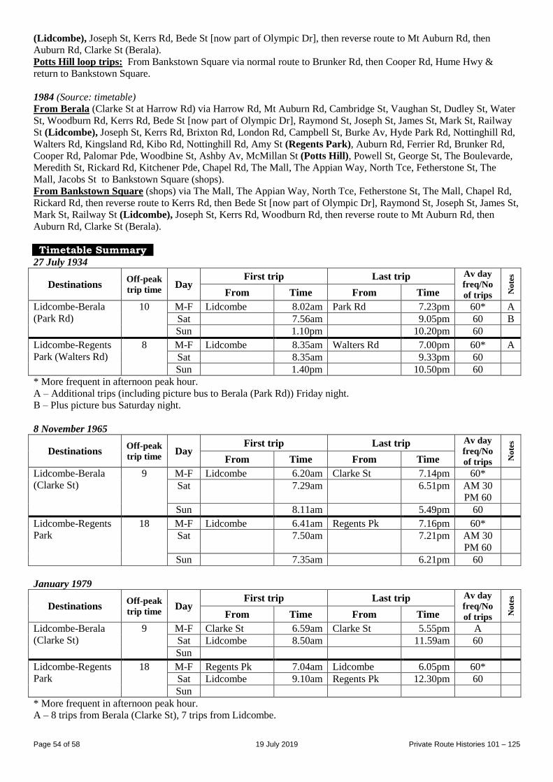
Page 54 of 58 19 July 2019 Private Route Histories 101 – 125
(Lidcombe), Joseph St, Kerrs Rd, Bede St [now part of Olympic Dr], then reverse route to Mt Auburn Rd, then
Auburn Rd, Clarke St (Berala).
Potts Hill loop trips: From Bankstown Square via normal route to Brunker Rd, then Cooper Rd, Hume Hwy &
return to Bankstown Square.
1984 (Source: timetable)
From Berala (Clarke St at Harrow Rd) via Harrow Rd, Mt Auburn Rd, Cambridge St, Vaughan St, Dudley St, Water
St, Woodburn Rd, Kerrs Rd, Bede St [now part of Olympic Dr], Raymond St, Joseph St, James St, Mark St, Railway
St (Lidcombe), Joseph St, Kerrs Rd, Brixton Rd, London Rd, Campbell St, Burke Av, Hyde Park Rd, Nottinghill Rd,
Walters Rd, Kingsland Rd, Kibo Rd, Nottinghill Rd, Amy St (Regents Park), Auburn Rd, Ferrier Rd, Brunker Rd,
Cooper Rd, Palomar Pde, Woodbine St, Ashby Av, McMillan St (Potts Hill), Powell St, George St, The Boulevarde,
Meredith St, Rickard Rd, Kitchener Pde, Chapel Rd, The Mall, The Appian Way, North Tce, Fetherstone St, The
Mall, Jacobs St to Bankstown Square (shops).
From Bankstown Square (shops) via The Mall, The Appian Way, North Tce, Fetherstone St, The Mall, Chapel Rd,
Rickard Rd, then reverse route to Kerrs Rd, then Bede St [now part of Olympic Dr], Raymond St, Joseph St, James St,
Mark St, Railway St (Lidcombe), Joseph St, Kerrs Rd, Woodburn Rd, then reverse route to Mt Auburn Rd, then
Auburn Rd, Clarke St (Berala).
Timetable Summary 27 July 1934
Destinations Off-peak
trip time Day
First trip Last trip Av day
freq/No
of trips No
tes
From Time From Time
Lidcombe-Berala
(Park Rd)
10 M-F Lidcombe 8.02am Park Rd 7.23pm 60* A
Sat 7.56am 9.05pm 60 B
Sun 1.10pm 10.20pm 60
Lidcombe-Regents
Park (Walters Rd)
8 M-F Lidcombe 8.35am Walters Rd 7.00pm 60* A
Sat 8.35am 9.33pm 60
Sun 1.40pm 10.50pm 60
* More frequent in afternoon peak hour.
A – Additional trips (including picture bus to Berala (Park Rd)) Friday night.
B – Plus picture bus Saturday night.
8 November 1965
Destinations Off-peak
trip time Day
First trip Last trip Av day
freq/No
of trips No
tes
From Time From Time
Lidcombe-Berala
(Clarke St)
9 M-F Lidcombe 6.20am Clarke St 7.14pm 60*
Sat 7.29am 6.51pm AM 30
PM 60
Sun 8.11am 5.49pm 60
Lidcombe-Regents
Park
18 M-F Lidcombe 6.41am Regents Pk 7.16pm 60*
Sat 7.50am 7.21pm AM 30
PM 60
Sun 7.35am 6.21pm 60
January 1979
Destinations Off-peak
trip time Day
First trip Last trip Av day
freq/No
of trips No
tes
From Time From Time
Lidcombe-Berala
(Clarke St)
9 M-F Clarke St 6.59am Clarke St 5.55pm A
Sat Lidcombe 8.50am 11.59am 60
Sun
Lidcombe-Regents
Park
18 M-F Regents Pk 7.04am Lidcombe 6.05pm 60*
Sat Lidcombe 9.10am Regents Pk 12.30pm 60
Sun
* More frequent in afternoon peak hour.
A – 8 trips from Berala (Clarke St), 7 trips from Lidcombe.
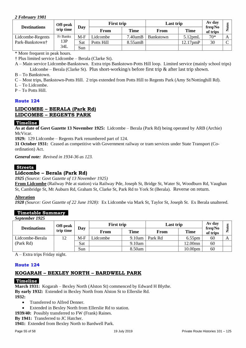
Page 55 of 58 19 July 2019 Private Route Histories 101 – 125
2 February 1981
Destinations Off-peak
trip time Day
First trip Last trip Av day
freq/No
of trips No
tes
From Time From Time
Lidcombe-Regents
Park-Bankstown†
Fr Banks
13P
34L
M-F Lidcombe 7.40amB Bankstown 5.12pmL 70* A
Sat Potts Hill 8.55amB 12.17pmP 30 C
Sun
* More frequent in peak hours.
† Plus limited service Lidcombe – Berala (Clarke St).
A – Main service Lidcombe-Bankstown. Extra trips Bankstown-Potts Hill loop. Limited service (mainly school trips)
Lidcombe – Berala (Clarke St). Plus short-working/s before first trip & after last trip shown. B – To Bankstown.
C – Most trips, Bankstown-Potts Hill. 2 trips extended from Potts Hill to Regents Park (Amy St/Nottinghill Rd).
L – To Lidcombe.
P – To Potts Hill.
Route 124
LIDCOMBE – BERALA (Park Rd) LIDCOMBE – REGENTS PARK
Timeline As at date of Govt Gazette 13 November 1925: Lidcombe – Berala (Park Rd) being operated by ARB (Archie)
McVicar.
1929: 129 Lidcombe – Regents Park renumbered part of 124.
31 October 1931: Ceased as competitive with Government railway or tram services under State Transport (Co-
ordination) Act.
General note: Revived in 1934-36 as 123.
Streets
Lidcombe – Berala (Park Rd) 1925 (Source: Govt Gazette of 13 November 1925)
From Lidcombe (Railway Pde at station) via Railway Pde, Joseph St, Bridge St, Water St, Woodburn Rd, Vaughan
St, Cambridge St, Mt Auburn Rd, Graham St, Clarke St, Park Rd to York St (Berala). Reverse on return.
Alteration
1928 (Source: Govt Gazette of 22 June 1928): Ex Lidcombe via Mark St, Taylor St, Joseph St. Ex Berala unaltered.
Timetable Summary September 1925
Destinations Off-peak
trip time Day
First trip Last trip Av day
freq/No
of trips No
tes
From Time From Time
Lidcombe-Berala
(Park Rd)
12 M-F Lidcombe 9.10am Park Rd 6.55pm 60 A
Sat 9.10am 12.00mn 60
Sun 8.50am 10.00pm 60
A – Extra trips Friday night.
Route 124
KOGARAH – BEXLEY NORTH – BARDWELL PARK
Timeline March 1931: Kogarah – Bexley North (Alston St) commenced by Edward H Blythe.
By early 1932: Extended in Bexley North from Alston St to Ellerslie Rd.
1932:
Transferred to Alfred Denner.
Extended in Bexley North from Ellerslie Rd to station.
1939/40: Possibly transferred to FW (Frank) Raines.
By 1941: Transferred to JC Hatcher.
1941: Extended from Bexley North to Bardwell Park.
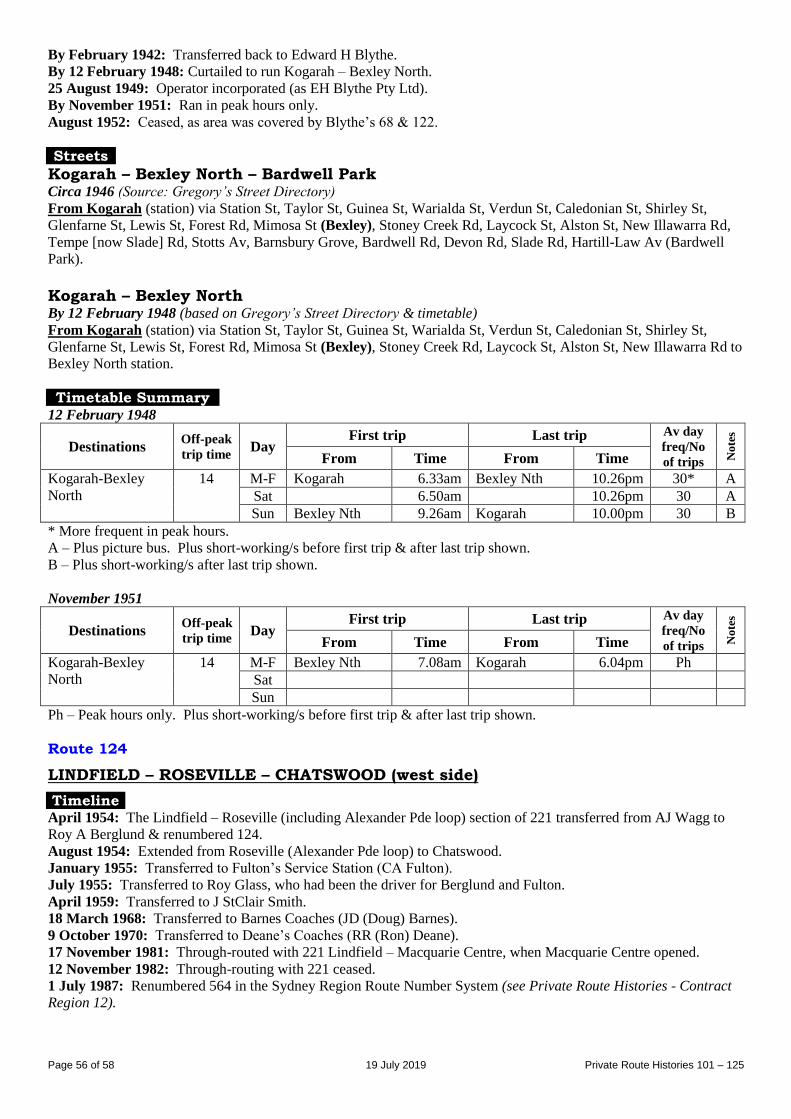
Page 56 of 58 19 July 2019 Private Route Histories 101 – 125
By February 1942: Transferred back to Edward H Blythe.
By 12 February 1948: Curtailed to run Kogarah – Bexley North.
25 August 1949: Operator incorporated (as EH Blythe Pty Ltd).
By November 1951: Ran in peak hours only.
August 1952: Ceased, as area was covered by Blythe’s 68 & 122.
Streets
Kogarah – Bexley North – Bardwell Park Circa 1946 (Source: Gregory’s Street Directory)
From Kogarah (station) via Station St, Taylor St, Guinea St, Warialda St, Verdun St, Caledonian St, Shirley St,
Glenfarne St, Lewis St, Forest Rd, Mimosa St (Bexley), Stoney Creek Rd, Laycock St, Alston St, New Illawarra Rd,
Tempe [now Slade] Rd, Stotts Av, Barnsbury Grove, Bardwell Rd, Devon Rd, Slade Rd, Hartill-Law Av (Bardwell
Park).
Kogarah – Bexley North By 12 February 1948 (based on Gregory’s Street Directory & timetable)
From Kogarah (station) via Station St, Taylor St, Guinea St, Warialda St, Verdun St, Caledonian St, Shirley St,
Glenfarne St, Lewis St, Forest Rd, Mimosa St (Bexley), Stoney Creek Rd, Laycock St, Alston St, New Illawarra Rd to
Bexley North station.
Timetable Summary 12 February 1948
Destinations Off-peak
trip time Day
First trip Last trip Av day
freq/No
of trips No
tes
From Time From Time
Kogarah-Bexley
North
14 M-F Kogarah 6.33am Bexley Nth 10.26pm 30* A
Sat 6.50am 10.26pm 30 A
Sun Bexley Nth 9.26am Kogarah 10.00pm 30 B
* More frequent in peak hours.
A – Plus picture bus. Plus short-working/s before first trip & after last trip shown.
B – Plus short-working/s after last trip shown.
November 1951
Destinations Off-peak
trip time Day
First trip Last trip Av day
freq/No
of trips No
tes
From Time From Time
Kogarah-Bexley
North
14 M-F Bexley Nth 7.08am Kogarah 6.04pm Ph
Sat
Sun
Ph – Peak hours only. Plus short-working/s before first trip & after last trip shown.
Route 124
LINDFIELD – ROSEVILLE – CHATSWOOD (west side)
Timeline April 1954: The Lindfield – Roseville (including Alexander Pde loop) section of 221 transferred from AJ Wagg to
Roy A Berglund & renumbered 124.
August 1954: Extended from Roseville (Alexander Pde loop) to Chatswood.
January 1955: Transferred to Fulton’s Service Station (CA Fulton).
July 1955: Transferred to Roy Glass, who had been the driver for Berglund and Fulton.
April 1959: Transferred to J StClair Smith.
18 March 1968: Transferred to Barnes Coaches (JD (Doug) Barnes).
9 October 1970: Transferred to Deane’s Coaches (RR (Ron) Deane).
17 November 1981: Through-routed with 221 Lindfield – Macquarie Centre, when Macquarie Centre opened.
12 November 1982: Through-routing with 221 ceased.
1 July 1987: Renumbered 564 in the Sydney Region Route Number System (see Private Route Histories - Contract
Region 12).
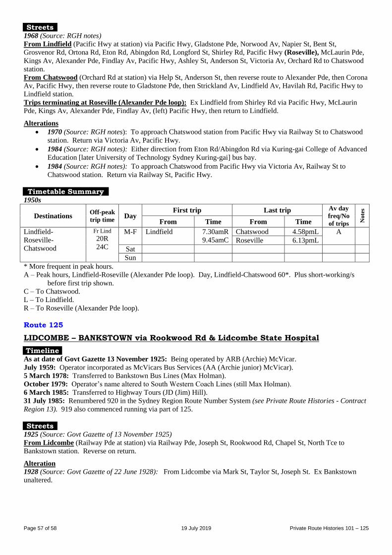
Page 57 of 58 19 July 2019 Private Route Histories 101 – 125
Streets 1968 (Source: RGH notes)
From Lindfield (Pacific Hwy at station) via Pacific Hwy, Gladstone Pde, Norwood Av, Napier St, Bent St,
Grosvenor Rd, Ortona Rd, Eton Rd, Abingdon Rd, Longford St, Shirley Rd, Pacific Hwy (Roseville), McLaurin Pde,
Kings Av, Alexander Pde, Findlay Av, Pacific Hwy, Ashley St, Anderson St, Victoria Av, Orchard Rd to Chatswood
station.
From Chatswood (Orchard Rd at station) via Help St, Anderson St, then reverse route to Alexander Pde, then Corona
Av, Pacific Hwy, then reverse route to Gladstone Pde, then Strickland Av, Lindfield Av, Havilah Rd, Pacific Hwy to
Lindfield station.
Trips terminating at Roseville (Alexander Pde loop): Ex Lindfield from Shirley Rd via Pacific Hwy, McLaurin
Pde, Kings Av, Alexander Pde, Findlay Av, (left) Pacific Hwy, then return to Lindfield.
Alterations
1970 (Source: RGH notes): To approach Chatswood station from Pacific Hwy via Railway St to Chatswood
station. Return via Victoria Av, Pacific Hwy.
1984 (Source: RGH notes): Either direction from Eton Rd/Abingdon Rd via Kuring-gai College of Advanced
Education [later University of Technology Sydney Kuring-gai] bus bay.
1984 (Source: RGH notes): To approach Chatswood from Pacific Hwy via Victoria Av, Railway St to
Chatswood station. Return via Railway St, Pacific Hwy.
Timetable Summary 1950s
Destinations Off-peak
trip time Day
First trip Last trip Av day
freq/No
of trips No
tes
From Time From Time
Lindfield-
Roseville-
Chatswood
Fr Lind
20R
24C
M-F Lindfield 7.30amR
9.45amC
Chatswood 4.58pmL A
Roseville 6.13pmL
Sat
Sun
* More frequent in peak hours.
A – Peak hours, Lindfield-Roseville (Alexander Pde loop). Day, Lindfield-Chatswood 60*. Plus short-working/s
before first trip shown.
C – To Chatswood.
L – To Lindfield.
R – To Roseville (Alexander Pde loop).
Route 125
LIDCOMBE – BANKSTOWN via Rookwood Rd & Lidcombe State Hospital
Timeline As at date of Govt Gazette 13 November 1925: Being operated by ARB (Archie) McVicar.
July 1959: Operator incorporated as McVicars Bus Services (AA (Archie junior) McVicar).
5 March 1978: Transferred to Bankstown Bus Lines (Max Holman).
October 1979: Operator’s name altered to South Western Coach Lines (still Max Holman).
6 March 1985: Transferred to Highway Tours (JD (Jim) Hill).
31 July 1985: Renumbered 920 in the Sydney Region Route Number System (see Private Route Histories - Contract
Region 13). 919 also commenced running via part of 125.
Streets 1925 (Source: Govt Gazette of 13 November 1925)
From Lidcombe (Railway Pde at station) via Railway Pde, Joseph St, Rookwood Rd, Chapel St, North Tce to
Bankstown station. Reverse on return.
Alteration
1928 (Source: Govt Gazette of 22 June 1928): From Lidcombe via Mark St, Taylor St, Joseph St. Ex Bankstown
unaltered.
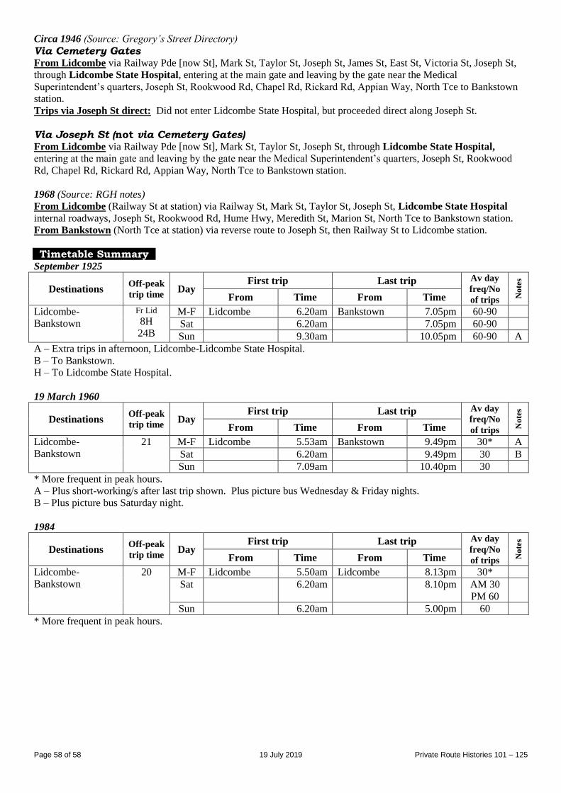
Page 58 of 58 19 July 2019 Private Route Histories 101 – 125
Circa 1946 (Source: Gregory’s Street Directory)
Via Cemetery Gates From Lidcombe via Railway Pde [now St], Mark St, Taylor St, Joseph St, James St, East St, Victoria St, Joseph St,
through Lidcombe State Hospital, entering at the main gate and leaving by the gate near the Medical
Superintendent’s quarters, Joseph St, Rookwood Rd, Chapel Rd, Rickard Rd, Appian Way, North Tce to Bankstown
station.
Trips via Joseph St direct: Did not enter Lidcombe State Hospital, but proceeded direct along Joseph St.
Via Joseph St (not via Cemetery Gates) From Lidcombe via Railway Pde [now St], Mark St, Taylor St, Joseph St, through Lidcombe State Hospital,
entering at the main gate and leaving by the gate near the Medical Superintendent’s quarters, Joseph St, Rookwood
Rd, Chapel Rd, Rickard Rd, Appian Way, North Tce to Bankstown station.
1968 (Source: RGH notes)
From Lidcombe (Railway St at station) via Railway St, Mark St, Taylor St, Joseph St, Lidcombe State Hospital
internal roadways, Joseph St, Rookwood Rd, Hume Hwy, Meredith St, Marion St, North Tce to Bankstown station.
From Bankstown (North Tce at station) via reverse route to Joseph St, then Railway St to Lidcombe station.
Timetable Summary September 1925
Destinations Off-peak
trip time Day
First trip Last trip Av day
freq/No
of trips No
tes
From Time From Time
Lidcombe-
Bankstown
Fr Lid
8H
24B
M-F Lidcombe 6.20am Bankstown 7.05pm 60-90
Sat 6.20am 7.05pm 60-90
Sun 9.30am 10.05pm 60-90 A
A – Extra trips in afternoon, Lidcombe-Lidcombe State Hospital.
B – To Bankstown.
H – To Lidcombe State Hospital.
19 March 1960
Destinations Off-peak
trip time Day
First trip Last trip Av day
freq/No
of trips No
tes
From Time From Time
Lidcombe-
Bankstown
21 M-F Lidcombe 5.53am Bankstown 9.49pm 30* A
Sat 6.20am 9.49pm 30 B
Sun 7.09am 10.40pm 30
* More frequent in peak hours.
A – Plus short-working/s after last trip shown. Plus picture bus Wednesday & Friday nights.
B – Plus picture bus Saturday night.
1984
Destinations Off-peak
trip time Day
First trip Last trip Av day
freq/No
of trips No
tes
From Time From Time
Lidcombe-
Bankstown
20 M-F Lidcombe 5.50am Lidcombe 8.13pm 30*
Sat 6.20am 8.10pm AM 30
PM 60
Sun 6.20am 5.00pm 60
* More frequent in peak hours.