Embed Size (px)
Citation preview
SWDP 45: Directions for Growth Outside the City Administrative Boundary
Worcester urban extensions
Within the areas identified on the Policies Map, six sustainable, well-designed urban
extension are proposed. These sites will come forward in accordance with individual
masterplans / delivery plans (to be agreed with the local planning authority) and the
requirements in A – F below.
A. SWDP45/1 Broomhall Community and Norton Barracks Community (Worcester
South urban extension):
i. Delivery of approximately 20ha of employment land and around 2,600
dwellings. The rate of delivery will be dependent upon the phased
implementation of the Worcester Transport Strategy and in particular
the dualling of the A4440 Southern Link Road.
ii. The dwellings will be of mixed size and type in accordance with the
requirements of policy SWDP 14, and up to 40% will be affordable
housing in accordance with the requirements of policy SWDP 15.
iii. The diagram for SWDP45/1 below shows the broad distribution of land
uses as well as the various policy requirements, which include a
centrally located Local Centre incorporating:
a range of community facilities and services including a two-form
entry primary school, community building, emergency services
infrastructure, children’s centre and youth facilities;
local convenience and comparison retailing; and
mixed uses comprising modest scale business development (B1
only) and A2 uses, plus A3, A4 and A5 use class development of
a scale appropriate to serving the local community.
iv. The Local Centre should include no more than 2,500 square metres net
of retail floorspace and no single convenience store should exceed
2,000 square metres net.
v. There will be no built development in the parts of the site liable to
flooding, as defined in the Strategic Flood Risk Assessment and / or a
site specific Flood Risk Assessment.
vi. New and enhanced sports and social facilities at Norton Barracks.
vii. Subject to A viii and ix below, in the Significant Gap to the south of
Norton Barracks, between Norton Road and the M5, only uses that
maintain the openness of the land will be permitted.
viii. No more than 85 of the 2,600 dwellings will be permitted east of Norton
Road. Up to 40 of these will be in the Significant Gap, to provide
surveillance of the proposed community, sports and recreation facilities.
ix. Provision of a site for Travellers of up to 10 pitches within the urban
extension1.
x. Contributions to infrastructure, in accordance with SWDP7 C, including
education, sporting and recreational facilities, and emergency services
infrastructure.
xi. Measures, including proportionate contributions directly related to the
development, to support and safeguard the implementation of relevant
schemes set out in the Worcestershire LPT3, including the adopted
Worcester Transport Strategy, such as: improvements to the A4440
(including phased dualling), the A38 and associated highways, public
transport, cycle and walking infrastructure and services which shall
include at least two grade-separated pedestrian / cycle crossings;
improved accessibility by non-car modes to Worcester city centre,
including a potential parking hub close to the A4440, to be agreed in
consultation with Worcestershire County Council.
xii. Safeguarding land on the southern side of the A4440 for the dualling of
the road and the provision of the pedestrian and cycle bridges needed
to provide sustainable transport links between the development and
Worcester city walk and cycle networks.
xiii. A road network hierarchy and legible road layout within and adjoining
the urban extension supporting the functions of the new
neighbourhood, including traffic calming measures to safeguard the
amenity of the Norton Barracks community.
xiv. Footpath and cycle networks within the development including safe
links to Worcester city, the Local Centre and Norton Barracks.
xv. The provision of Local Green Network, including:
Play facilities, sporting and informal recreational facilities such
as allotments.
Sustainable urban drainage systems.
A Local Green Network buffer to the west of Norton Road
separating the Broomhall and Norton Barracks communities, of a
scale that maintains their individual identities.
A Local Green Network buffer along the whole southern
boundary immediately to the north of Broomhall Lane, providing
a framework for the built development consistent with local
landscape character.
A Local Green Network buffer to the north of Norton Barracks,
between Norton Road and the railway line, designed to overcome
visual and noise impacts of business development to the north
by separating new and existing uses.
1 See also SWDP 17 – Travellers and Travelling Showpeople.
Local Green Network adjacent to the A4440 (after allowing for
dualling or other improvements), to provide a framework for the
built development, mitigate noise and flood risk and maintain the
individual identities of Broomhall and St Peter the Great to the
north.
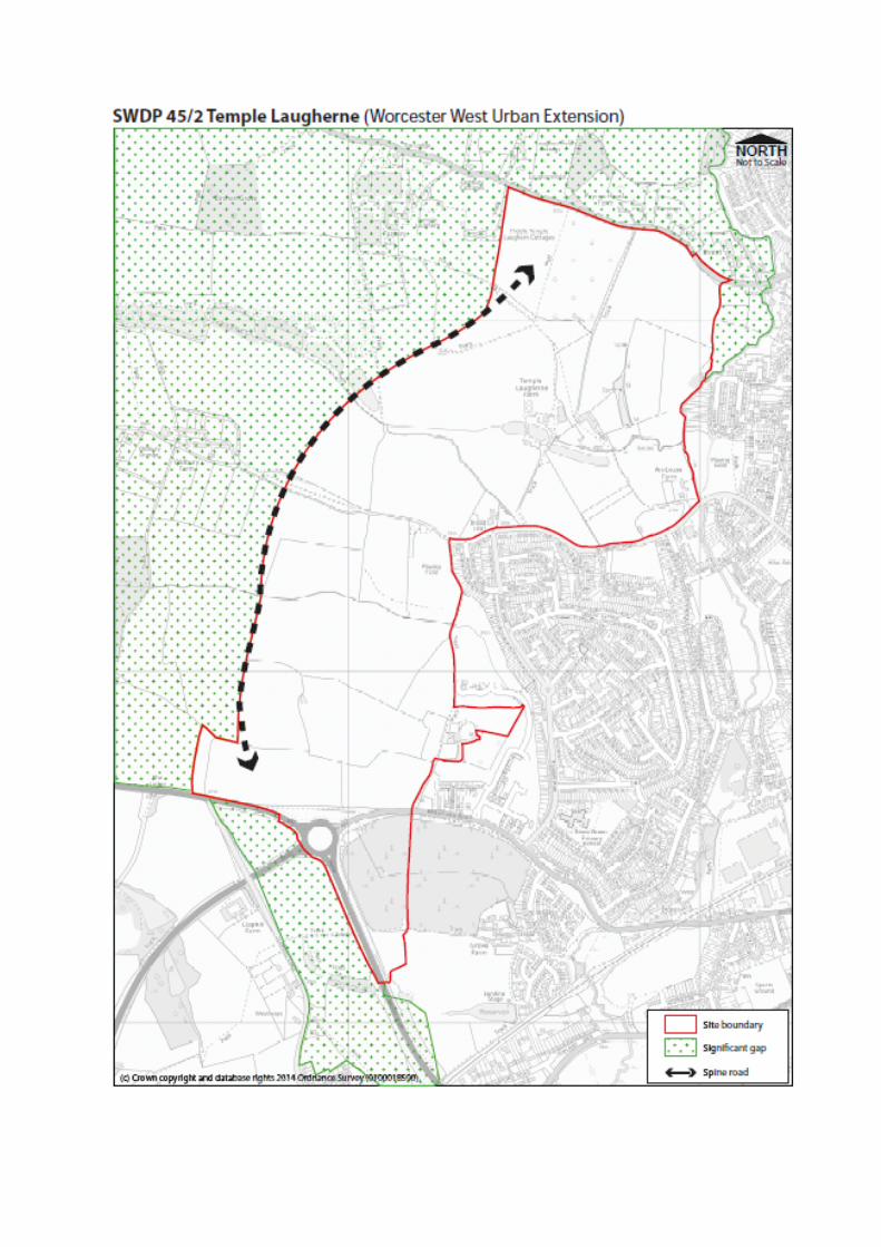
B. SWDP45/2 Temple Laugherne (Worcester West urban extension):
The diagram for SWDP45/2 below, shows the area that relates to this allocation.
i. Delivery of approximately 5ha of employment land.
ii. Delivery of around 2,150 dwellings. The rate of delivery will be
dependent upon the phased implementation of the Worcester Transport
Strategy and, in particular, the dualling of the A4440 Southern Link
Road. The disposition of proposed uses within the allocation boundary
will need to ensure the comprehensive development of the allocation as
a whole and provide an integrated and cohesive urban design
facilitating movements within the site and to / from the City.
iii. The dwellings will be of mixed size and type in accordance with the
requirements of policy SWDP 14, and up to 40% will be affordable
housing in accordance with the requirements of policy SWDP 15.
iv. Local convenience and comparison retailing within a Neighbourhood
Centre; the Neighbourhood Centre should include not more than 1,500
square metres of net retail floorspace and no single convenience store
should exceed 1,000 square metres net.
v. A range of community facilities and services, including a two-form entry
primary school and community hall.
vi. Provision of a site for Travellers of up to 10 pitches within the urban
extension2.
vii. There will be no built development in the parts of the site liable to
flooding, as defined in the Strategic Flood Risk Assessment and / or a
site specific Flood Risk Assessment.
viii. The development of a Local Green Network, including:
A network of open spaces, including play facilities, sporting and
informal recreational facilities such as allotments.
Measures for the protection and enhancement of the Earl’s Court
Scheduled Monument and its setting.
Measures which will deliver both Green Infrastructure and water
management objectives.
ix. Measures to maintain separation of the urban extension from Crown
East and Lower Broadheath.
x. Contributions to infrastructure, in accordance with SWDP 7C, including
transportation, education, sporting and recreational facilities, and
emergency services infrastructure.
2 See also SWDP 17 – Travellers and Travelling Showpeople
xi. Measures, including proportionate contributions directly related to the
development, to support and safeguard the implementation of relevant
schemes set out in the Worcestershire LPT3, including the adopted
Worcester Transport Strategy, which includes the phased dualling of the
A4440 Southern Link Road; the delivery of a spine road within the site
between the A44 and the Martley Road; and improved accessibility by
non-car modes to Worcester city centre, including a potential parking
hub close to the A4440, to be agreed in consultation with
Worcestershire County Council.
C. SWDP45/3 Kilbury Drive (Worcester East urban extension):
i. Delivery of around 250 dwellings.
ii. The dwellings will be of mixed size and type in accordance with the
requirements of policy SWDP 14, and up to 40% will be affordable
housing in accordance with the requirements of policy SWDP 15.
iii. There will be no built development in the parts of the site liable to
flooding, as defined in the Strategic Flood Risk Assessment and / or a
site specific Flood Risk Assessment.
iv. Contribute to public realm enhancements related to local shopping
provision at Baynham Drive.
v. Measures to maintain a physical and visual separation from Swinesherd
Way, apart from access to the pedestrian crossing.
vi. A network of open spaces including play facilities, informal open space
and allotments.
vii. The development of the Local Green Network.
viii. Measures to improve accessibility by non-car modes to Worcester city
centre, local employment areas, schools, Sixth Form College, sports
centre, hospital and Worcester Woods Country Park.
ix. Contributions to infrastructure, in accordance with SWDP 7C, including
transportation, education, sporting and recreational facilities,
emergency services infrastructure and village hall.
x. A traffic-calmed central spine road linking Spetchley Road to
Whittington Road with appropriate public transport facilities..
xi. Only built development for uses compatible with the flood risk
vulnerability classification in the 2012 Technical Guidance to the
National Planning Policy Framework will be permitted in Flood Risk
Zones 2, 3a or 3b.
D. SWDP45/4 Gwillam’s Farm (Worcester North urban extension):
i. Delivery of approximately 250 dwellings.
ii. The dwellings will be of mixed size and type in accordance with the
requirements of policy SWDP 14, and up to 40% will be affordable
housing in accordance with the requirements of policy SWDP 15.
iii. Enhanced local shopping provision.
iv. Measures to maintain a physical and visual separation from Bevere in
order to protect the setting of the Conservation Area and preserve the
setting of the Listed Buildings.
v. A network of open spaces including play facilities, informal open space
and allotments.
vi. The development of the Local Green Network.
vii. Contributions to infrastructure, in accordance with SWDP 7C, including
transportation, education, sporting and recreational facilities, and
emergency services infrastructure.
viii. Measures to improve accessibility by non-car modes to Worcester city
centre, Bevere, River Severn, local employment areas, schools and
leisure centre.
E. SWDP45/5 Land at Swinesherd Way
i. Delivery of around 300 dwellings.
ii. The dwellings will be of mixed size and type in accordance with the
requirements of policy SWDP 14, and up to 40% will be affordable
housing in accordance with the requirements of policy SWDP 15.
iii. There will be no built development in the parts of the site liable to
flooding, as defined in the Strategic Flood Risk Assessment and / or a
site specific Flood Risk Assessment.
iv. Provision of a cycle / pedestrian bridge across the A4440 to connect
with Spetchley Road, together with measures to secure safe access to
local services at Whittington and employment opportunities provided by
SWDP43/23.
v. Provision of a new principal vehicular access on the site frontage to the
A4440, together with measures to prevent or limit vehicular use of other
accesses to / from the site.
vi. The development of a Local Green Network to include open spaces,
including equipped play space, which will deliver both Green
Infrastructure and water management objectives.
vii. A comprehensive landscaping scheme and other appropriate measures
which achieves a good standard of amenity in the site, taking account of
the acoustic environment including traffic noise arising from the A4440
and M5.
viii. Contributions to infrastructure, in accordance with SWDP 7C, including
transportation infrastructure necessary to improve accessibility, in
particular by non-car modes; education; sporting and recreational
facilities; and emergency services infrastructure.
F. SWDP45/6 Worcester Technology Park (South Phase):
i. Delivery of a sustainable, well-designed technology park of
approximately 16ha (Worcester Technology Park South Phase) for
research and development and manufacturing related to environmental
and new technologies or associated businesses, to be integrated with
the land to the north that already has permission for business uses.
ii. Off-site highway works and financial contributions, in accordance with
SWDP 7C, necessary to support access to the site.
iii. Landscaping that contributes to the Local Green Network and the
setting of existing and altered public routes through the site.
iv. Measures to support and safeguard the implementation of relevant
schemes set out in the Worcester LTP3, including the adopted
Worcester Transport Strategy, and to provide adequate accessibility by
non-car modes to Worcester city centre and key residential and
transport (interchange) destinations, facilities and services across
Worcester city as a whole.
v. The safeguarding of pedestrian and cycle access through the allocation
through the retention or relocation of public rights of way.
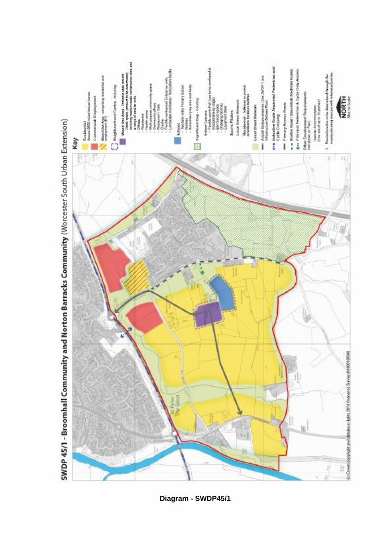
Diagram - SWDP45/1
Reasoned Justification
The Development Strategy
1. When other sources of supply including the urban capacity of the city are taken into
account, the evidence underpinning SWDP 3 shows that about 41ha of employment
land and about 5,560 dwellings will be required around the urban edge of the city, of
which 80 are within the city and the rest within the districts of Malvern Hills and
Wychavon.
2. The analysis of the evidence indicates that the best prospect for achieving a
sustainable pattern of development is by urban concentration, through the creation of
five new urban extensions adjoining Worcester city to accommodate housing and
mixed use development. This will enable high-quality design concepts to be pursued
via masterplans. Issues to be addressed / incorporated will include:
a. Housing of mixed size and tenure.
b. Targeted local employment opportunities.
c. The extension of the existing Local Green Network.
d. Open space, sporting and recreational facilities.
e. Educational provision.
f. Neighbourhood shopping facilities.
g. Infrastructure for the emergency services.
h. Community facilities, including primary health care.
3. The five locations are:
a. South of Worcester (Broomhall Community and Norton Barracks Community).
b. West of Worcester (Temple Laugherne).
c. East of Worcester (Kilbury Drive).
d. East of Worcester (Swinesherd Way).
e. North of Worcester (Gwillam’s Farm).
4. The only two areas that could reasonably accommodate large-scaledevelopment are
located to the south and west of the city. Both will provide the following:
a. Economic benefits through the provision of new employment opportunities in line
with market demand.
b. New housing.
c. Support to the improvement of links from east to west and particularly to the M5.
d. Links into the city through the provision of improved pedestrian / cycle and public
transport facilities.
5. A somewhat greater proportion of development will go to the south (20ha of
employment development and 2,600 dwellings) than to the west (5ha of employment
and 2,150 dwellings).
6. In addition, the evidence supports the allocation of a sub-regional employment site as
a sixth urban extension to meet Worcester’s employment needs, to be located to the
southeast of Junction 6 of the M5. The city successfully accommodated growth at
Warndon Villages in the 1990s. The objective is to use the best examples of that
development, together with improvements that have emerged in urban design and
green infrastructure planning, to create high quality places to live and work. Four
issues play a significant role in defining how and where Worcester should grow to
meet its economic and housing growth requirements. These are:
A. Accessibility and Sustainable Transport
7. Providing access to jobs and essential services is a crucial part of delivering
sustainable, economically-led and inclusive communities. Development at locations
that can be accessed by means other than the private car and that provide efficient,
accessible and attractive links to the city and the key employment, residential,
health, education, leisure and transport (interchange) facilities, services and
destinations across the city as a whole is essential. In conjunction with improvements
to highway infrastructure at key points across the south Worcestershire area, this
integrated and multi-modal approach will increase the efficiency of the transport
network, help to reduce transport related carbon emissions and can improve the local
environment and promote social inclusion.
8. It is vital that areas of growth link into the sustainable transport network and this can
be achieved through the principles of sustainable development identified in SWDP 1
and sustainable transport in SWDP 4. This would bring benefits in terms of
accessibility, economy, environment, air quality, health and overall quality of life. By
allocating development in a number of strategic locations around the city, rather than
in a single location, the potential to enhance public transport services via key
transport corridors to / from Worcester is maximised. New or improved local public
transport (bus) services will be provided to link the new developments with the city
centre and key employment, residential, health, education, leisure and transport
(interchange) facilities, service and destinations across the city as a whole and also
the new housing areas and link to the existing settlements beyond the city. As part of
the strategy to reduce congestion on the key arterial corridors into and across the city
additional parking hubs could be delivered at or close to the urban extensions
providing the opportunity to capture inbound car-borne traffic movement.
9. Every transport component is essential in making the whole strategy work.
Worcestershire County Council’s transport assessment looked at all aspects of
transport including public transport, cycling and walking. This identified:
a. The impact of the planned development on the capacity and the operation of the
Worcester city network and the south Worcestershire strategic transport network
as a whole.
b. The package of transport infrastructure and service enhancement schemes
needed to accommodate the travel demand generated by the planned
development.
c. The costs of mitigating transport schemes.
B. Sustaining and Enhancing the Historic Character and Setting of
Worcester
10. Worcester is a county town within a rural setting that is locally distinctive. Retaining
important views and defining local character are considered to be very important.
Much of the city’s distinctive and historic character is maintained through sustaining
and enhancing heritage assets such as the conservation areas and listed buildings
within its boundaries, as well as promoting the Local Green Network and protecting
significant strategic views. In addition, the green belt to the north of Worcester fulfils
the green belt purpose set out in the Framework “… to preserve the setting and
special character of historic towns”, as well as preventing the neighbouring towns
of Worcester city and Droitwich Spa from merging into one another and checking the
unrestricted sprawl of the West Midlands conurbation. Evidence from the Green Belt
Review suggests that regardless of the extent to which the city may have to identify
further land to meet its development requirements and needs, there would be areas
of land outside the built-up areas of the city that should be retained as open land.
This will be necessary to avoid the coalescence of villages whose individual identity
and separation contribute to the distinctive rural setting of the city. The evidence from
the Review demonstrates that the boundaries of the Green Belt at Worcester are
robust and defendable.
C. Nature Conservation
11. The protection of areas with nature conservation value is a key element in ensuring
sustainable development. The Framework requires that for local plans to contribute to
the natural and local environment, planning policies should “… minimise impacts
on biodiversity and geodiversity”. The focus is on the preservation, restoration and
recreation of priority habitats, ecological networks and the protection and recovery of
priority species. Worcester’s Green Network is well established and valued and the
Green Infrastructure Study (2007) that was carried out supports this approach and
promotes a similar approach in the development areas. Furthermore, by linking local
green network extensions with existing routes, opportunities for walking and cycling
will be spread into the wider Worcester area.
D. Flooding
12. The identification of the urban extensions took full account of information on flood risk
and the vulnerability of land uses, informed by the Strategic Flood Risk Assessment
(Levels 1 and 2) as updated in 2012 and 2014. The SFRA takes into account sources
of flooding and the impacts of climate change. The aim is to direct development away
from areas at highest risk, but where development is necessary, making it safe
without increasing flood risk elsewhere. Having applied the sequential test,
development has been steered to areas with the lowest probability of flooding. The
search for sites avoided land wholly in the higher flood risk zones. Only small areas
of some of the urban extensions have land that has a higher flood risk zone warning.
On the basis of the SFRA evidence, the urban extensions are capable of
accommodating the development proposed on Flood Risk Zone 1, including the more
vulnerable development. Planning applications will need to be accompanied by site-
specific flood risk assessments where necessary.
Broomhall Community and Norton Barracks Community (SWDP45/1)
13. In assessing the development to the south, there are some important objectives that
need to be fulfilled and these would be an integral part of a comprehensive
masterplan. These objectives carry equal weight:
a. To create an environment that will be attractive to business investment, including
high technology, manufacturing and knowledge-based services.
b. To create a sustainable, balanced mix of uses and a distinctive new community
at Broomhall, which is self-sufficient in meeting its local needs.
c. To create Local Green Networks at a scale and layout that retain the individual
identities of the new Broomhall development and the existing Norton Barracks
settlement, allow for direct access to local services for pedestrians and cyclists ,
do not allow vehicular journeys, except where crossed by the Norton Road / Local
Centre / A38 link, and function as a biodiversity corridor and recreational space.
d. To ensure that the most important views of the Malvern Hills from the east of the
site are not impeded by the new development.
e. To ensure that appropriate measures are employed to avoid or mitigate water
course and surface water flooding and water quality concerns. The existing
watercourses will need to be retained in open areas of Local Green Network and
linked to appropriate SuDS techniques.
f. To enable appropriate improvements to the A4440 (Crookbarrow Way, Broomhall
Way and Teme Way) together with associated junction improvements, which will
include the provision of at least two grade-separated pedestrian / cycle crossings
(east and west).
g. To reduce car dependency by enabling efficient public transport, walking and
cycling movements within the development, whilst providing two-way
opportunities for access to services within the existing city as well as out to the
countryside.
h. To provide emergency services infrastructure serving the local community.
14. The Plan has extended the Significant Gap (previously the M5 Protection Corridor,
Worcester, and Strategic Gap, Wychavon) to the west of the M5 motorway so that
land to the east and south-east of Norton Barracks is now subject to SWDP 2 D. In
addition, land between Kempsey and the southern limit of the urban extension
remains as Significant Gap. Care will be needed in the treatment of the edges of the
development area. In order to help minimise the impact on the Norton Barracks
community, the Worcester South extension must include well-designed green buffer
areas and set out a clear road hierarchy, with the road beyond any commercial
development being traffic-calmed particularly in the vicinity of Norton Barracks. The
road network within the urban extension will need to provide a route through to the
Neighbourhood Centre from Norton Road roundabout and the A38.
Temple Laugherne (SWDP45/2)
15. The development to the west of Worcester would relate closely to the existing city,
but certain important objectives would need to be achieved. These are:
a. Provision for modern high technology and knowledge-based services, including
links to the University of Worcester and the opportunity to provide business start-
up units.
b. Create a sustainable, balanced mix of uses that will be an extension to the
existing city area.
c. Maintain a Significant Gap that provides physical and visual separation between
the development and the surrounding villages of Crown East and Lower
Broadheath so that their unique characters and the setting of the city are both
protected.
d. Ensure that the existing views across the area of the skyline of the city are not
adversely impacted by the new development.
e. Reduce car dependency by enabling efficient public transport, walking and
cycling within the development, whilst providing two-way opportunities for access
to services within the existing city as well as to the countryside.
f. Create a cohesive place that relates to the existing city while recognising the
importance of the landscape setting in providing an attractive living environment
for a wide range of household types. Managing the transition between urban and
rural will be essential in enabling the countryside to flow naturally into the
development area from north and west.
g. Ensure there is safe and attractive access connecting the urban extension and
Dines Green, to ensure enhanced connectivity between existing and new
settlements. Two points of vehicular access are needed to serve the site. One of
these will need to have direct access to the primary road network west of the city
linking to the A4440. The second will need to link to the city road network such
that impacts on traffic flows further into the city can be managed.
16. It will be important to ensure there is a smooth transition from the open countryside
into the urban area, so the green corridors must be sufficiently wide to allow the
countryside to flow into the area. Where possible, development will be defined by
natural physical boundaries, but in certain places (particularly the western boundary)
it will be guided by landscape and topographical evidence.
17. The protection of the Earl’s Court Scheduled Monument is consistent with SWDP 1, 6
and 24 and section 12 of the Framework.
18. The three smaller urban extensions are Kilbury Drive and Swinesherd Way (to the
east) and Gwillam’s Farm (to the north). Kilbury Drive and Gwillam’s Farm consist of
approximately 250 dwellings each, while Swinesherd Way will provide around 300.
Kilbury Drive (SWDP45/3)
19. This site is located to the east of the city on land between Kilbury Drive and
Swinesherd Way. It is well linked to the city and has good access to local facilities.To
be sustainable the development of this site would need to meet the following
objectives:
a. The creation of a sustainable and distinctive extension to the urban area,
providing an attractive living environment for a variety of household types.
b. The provision of a biodiversity rich open space, including recreational space, on
the sensitive higher ground to the north.
c. Reducing car dependency by facilitating efficient public transport, walking and
cycling movements within the development, whilst providing opportunities for
access to local shops, employment areas, local schools and other services within
the city as well as to the countryside.
d. Providing appropriate visual and physical treatment to the boundary with
Swinesherd Way.
e. Ensuring that appropriate measures are employed to mitigate noise and air
pollution from the A4440.
f. Ensuring that appropriate measures are employed to avoid or mitigate surface
water flooding and water quality concerns. The existing watercourse will need to
be retained in an open area and linked to an appropriate Sustainable Drainage
System.
Gwillam’s Farm (SWDP45/4)
20. This site lies immediately to the north of the city boundary, outside and to the west of
the Green Belt and relates well to the city. In order to achieve a sustainable
development here certain objectives would need to be met. These are:
a. The creation of a sustainable and distinctive extension to the urban area without
barriers that would hinder integrating new development with the existing urban
form.
b. A high standard of design, ensuring the development makes a positive
contribution to the quality of the environment consistent with its gateway location
and provides an attractive living environment for a variety of household types.
c. Retail development, including the existing retail use, must be restricted to a scale
appropriate to serving the local community and should not create a new centre or
retail destination.
d. To sustain and enhance the significance of heritage assets including the setting
of the Bevere Conservation Area and nearby listed buildings. The sensitive area
in the west of the site close to the Bevere Conservation Area will be used for
managed planting, open space and recreational provision serving the
development, which will create a buffer separating the new development and the
listed buildings, with development and landscaping being well-related to the
topography of the site and the entrance to the Conservation Area adjacent to
South Bevere.
e. To accommodate existing rights of way within the buffer to the west and on the
periphery of the site to the north, providing views of historic assets beyond the
site itself.
f. Reducing car dependency by enabling efficient public transport movements,
walking and cycling within the development whilst providing opportunities for
access to local shops, employment areas, local schools and other services.
Swinesherd Way (SWDP45/5)
21. This site lies to the east of Kilbury Drive between Swinesherd Way and the M5,
immediately to the north of Whittington. In order for development to be suitably
sustainable here the following objectives need to be achieved:
a. Minimise car dependency by securing bus penetration and safe cycle and
walking access by means of a bridge across Swinesherd Way, enabling
residents to reach local services and employment opportunities.
b. A comprehensive SuDS scheme that deals with surface water flooding.
c. No built development beyond Flood Zone 1.
d. An agreed landscaping scheme and other measures that will mitigate noise
pollution from the A4440 and M5 to acceptable levels.
e. Emergency vehicle and cycle / walking access only to Whittington village.
f. To create a Local Green Network at a scale and layout that functions as a
biodiversity corridor and recreational space.
Worcester Technology Park (SWDP45/6)
22. Although provision has been made for local employment opportunities within the city
and the urban extensions, there is evidence to support a 70ha (gross) sub-regional
employment site providing opportunities for existing manufacturing companies in the
area to consolidate and expand by relocating to this site. The land is located
immediately south-east of Junction 6 of the M5, a key gateway to the city. It lies
within Wychavon District, but as the site abuts the city boundary it will provide
serviced employment land to meet the growth of Worcester.
23. The North Phase of the Technology Park development (previously referred to as
Phase 1) is counted as a commitment for SWDP 3 purposes. Within the North Phase,
development will occupy up to 140,000 square metres on 27ha (net) next to J6 and
could potentially provide for new headquarters, manufacturing, distribution and
research and development facilities.
24. SWDP45/6 is the South Phase on the remainder of Worcester Technology Park,
providing space for a cluster of other commercial companies, potentially involved in
environmental and other high-technology sectors. Within the gross site allocation
delineated on the Policies Map, about 16ha (net) is identified for SWDP 3 purposes.
25. The completed development will be designed and landscaped to appear as a single
Technology Park and will include public open space, primary highway improvements
and an ecological corridor. Two points of access will be provided. The current
permission includes access to the Technology Park directly on to Crowle Lane at a
point between Crowle Lane / Pershore Lane roundabout and Trotshill Lane. This
route provides access to Warndon Villages and the city centre via the Trotshill
motorway bridge. Development proposals will be tested through the Worcester
Transport Models and the developer will fund any mitigation works, along with
improvements to public transport, walking and cycling links.
26. Worcester Technology Park is identified as a priority employment project within the
Game Changer Programme and has the full support of the local councils, as well as
the Worcestershire Local Enterprise Partnership, all of whom have invested in the
site.