Embed Size (px)
Citation preview

Suzhou FOIF Co., Ltd.
Tel: +86-512-65224904
Fax:+86-512-65230619
+86-512-65234905
E-mail: [email protected]
Web: http://www.foif.com.cn
Headquarters: Lat N31°18'12.8" , Long E120°37'53.8"
It´s professional
Since 1958
Bro
ch
ure
(E)
09
.10
Suzhou

A Brief Instruction to the Company
FOIF equipped with an advanced CNC (Computerised Numerical Control) machining centre,
turning machine centre, three coordinate measuring machines and testing equipments, and use
NX3 CAD/CAM computer assistant system for designing and manufacturing. “FOIF” is the
renowned brand in the survey & industry in the world. And the high quality was accepted
in most of customers. In 1996 FOIF's quality management system had attained ISO9001:
1994 Certification of DNV (Det Norske Veritas) and review the Certification of ISO9001:
2000 in 2002.
The quality of products keeps on high level and won several titles of honour by the National
Quality Supervise Department, China Machinery Industry Fine Products, etc. FOIF has set
up a sales net cover the whole China and the market share is always in the leading position.
The exports are more than 40%, the products export to Europe, America, Australia, Africa and
Asia, it also has a sales net cover the world.
In recently years, FOIF has expanded through joint venture and now includes a professional
factory manufacturing precision parts, a professional factory producing automatic levels and
a professional factory for accessories.
FOIF established an R & D Center for the research into advanced technology and creation of
new products. There are currently forty professional engineers, fifteen senior engineers and
thirteen technicians working on products development and annual research expenditure is
more than 5 per cent of sales.
FOIF's main products are surveying instruments, construction instruments, laser instruments
and tools in recent years FOIF have been establishing 8 series and approximately 100 models
products, including GNSS products, total station, electronic theodolite, optical theodolite, auto-
matic level, laser plummet, laser level and architecture installing instruments, etc.
Laser Plummet
Rotating Laser
Suzhou FOIF Co., Ltd. was set up on the basis of legal reform
from Suzhou irst ptical nstrument actory in August 1999. F O I F
Suzhou First Optical Instrument Factory was founded in 1958,
it produced the first 1" grade optical theodolite, the J2 optical
theodolite in 1968 and the DS3 in 1968, the first automatic
level in China. The first DCH1 EDM was developed in 1987
and the first total station DQZ2 in 1996. From 1986 to 1996
the company worked successively on the manufacturing and
assembly technology of Wild T2 and Leica DI1600. Suzhou
FOIF also assembled the Sokkia DT2 EDM in 1992. FOIF is
a professional enterprise of designing, manufacturing and sale
for surveying products, it is high-tech enterprise and was awar-
ded a certificate from Chinese government as an “Honouring
Contracts and Keeping Promise Enterprise” for Grade AAA in
Jiangsu province. FOIF is the first enterprise in China which
produces a total station used reflectorless technology.
Line Laser
Automatic Level
Accessories
Total Station
Data Collector
Theodolite
Laser Meter
GNSS Product
1966 EDM 5B 1968 Level DS3 1986 Rotating laser JP1
1968 Theodolite J2
1975 Laser Theodolite 1987 EDM DCH1 1986/1996 T2+DI1600
Certificate for ManufactoryWild T2
ISO 9001 Certificate CE Certificate Brand Name Products China Product TOP500
Software
1
4
7
8
9
12
13
14
15
18
16
Content
2010 Product Brochure
2010 Product Brochure
Note:Illustrations, descriptions and technical specifications are not binding and may change

GNSS Product GNSS Product
2
Features
Technical Data
A20 GNSS Receiver
1
Dimensions (h*d*w*)
Static
Position Accuracy
A20
22.7cm 20.3cm 9.5cm
5mm+0.5ppm(Horizontal); 10mm+0.5ppm(Vertical)
IP67 (IEC60529)
60s/35s/1s
Channels
Time to first fix (C/W/R)
Up to 76 universal channels(Factory Optional)
Water and dust protection
RTK 10mm+1ppm(Horizontal); 20mm+1ppm(Vertical)
2.0m(6.6 ft) pole drop
Shock
3G satellite tracking (GPS, Glonass, Galileo)
Advanced GNSS tracking performance
Advanced multipath mitigation
Advanced rugged design
All-in-one; Flexibility
Base and rover communications options to suit any application
Voice messages
Up to 76 universal tracking channels options
OLED display with superior brightness & temperature range
5mm+1ppm(Horizontal); 10mm+1ppm(Vertical)
10mm+1ppm(Horizontal); 20mm+1ppm(Vertical)
2.0m(6.6 ft) pole drop
16.9cm 15.2cm 10.6cm
Parallel 26 channels
IP67 (IEC60529)
SGS828
60s/35s/1s
The base/rover station could be used as a rover/base station by change the setting
Advanced GNSS tracking performance
Integrated, Cable-free GPS system
Advanced multipath mitigation
SGS828 Integrated RTK GPS Receiver
All-in-one; Flexibility
Advanced rugged design
Dimensions (h*d*w*)
Water and dust protection
Time to first fix (C/W/R)
Technical Data
Position Accuracy
Channels
Static
Shock
Features
RTK
The base/rover station could be used as a rover/base station by change the setting
SD2GB
SDSD4GB
IP67
IP67

GNSS Product Total Station
Technical Data
128M large-capacity memory
Long life Li-ion battery
Features
43
SGS818 Integrated Static GPS Receiver
Integrated GPS antenna, data memory and batteries
Dimensions (h*d*w*)
Position Accuracy
SGS818
16.1cm 15.2cm 10.6cm
5mm+1ppm(Horizontal); 10mm+1ppm(Vertical)
IP67 (IEC60529)
Channels
Parallel 12 channels
Water and dust protection
1.2m(4 ft) drop
Shock
SD2GB
USB host/USB slave/RS-232C/Bluetooth (Factory optional)
2mm+2ppm
1 to 2000m
1 to 2500m
7 8 9
4 5 6
1 2 3
0 ¡À
RTS810
/
/
/
0.5 /1 (or 0.1mgon/0.2mgon)
1GB standard, extendible(2GB)
Pa
IP55 (IEC60529)
1 /2 /3 /5
Absolute encoder
1 30
x30
2mm+2ppm
1 to 5000m
3mm+2ppm
1 to 200m
1 to 700m
Professional onboard software: FOIF Survey_TS or FOIF FieldGenius (Optional)
OTS810
/
Built-in temperature and pressure sensors
OTS/RTS810 seriesWindows CE Total Station
Windows CE 5.0 operating system
Large full colour graphic display, touch screen
Measurement range (Good condition)
Multiple interface options
Water and dust protection
Dual-speed drives
Distance measurement
Reflective sheet/RP30
Guide light system
Technical Data
Angle measurement
Reading system
Reflectorless
Single prism
Three prisms
Reflectorless
Magnification
Field of view
Telescope
Features
Accuracy
Accuracy
Display resolution
Interface
Memory
Prism
.
Data processing software
FOIF Geomatics Office 2008
CLASS 2 LASER PRODUCT
Total Station Total Station
h t tp : / /www. fo i f . com.cn h t tp : / /www. fo i f . com.cn
7 8 9
4 5 6
1 2 3
0 ¡ À
>12h
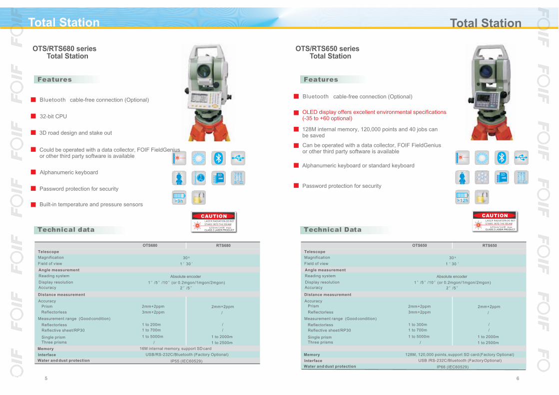
OTS/RTS650 series Total Station
Technical Data
Features
Distance measurement
Measurement range (Good condition)
Accuracy
2mm+2ppm
1 to 300m
Magnification
Telescope
Reflectorless
Reflective sheet/RP30 1 to 700m
OTS650 RTS650
2mm+2ppm
x30
1 to 5000m Single prism
Three prisms
1 to 2000m
1 to 2500m
/
/
/
3mm+2ppm
Accuracy 2 /5
Angle measurement
Reading system
1 /5 /10 (or 0.2mgon/1mgon/2mgon)Display resolution
Absolute encoder
Memory
/ Reflectorless
Prism
Field of view 1 30
128M, 120,000 points, support SD card (Factory Optional)
Water and dust protection IP66 (IEC60529)
Interface USB /RS-232C/Bluetooth (Factory Optional)
7 8 9
4 5 6
1 2 3
0 ¡À
OTS/RTS680 series Total Station
Technical data
Features
Distance measurement
Measurement range (Good condition)
Accuracy
2mm+2ppm
1 to 200m
Magnification
Telescope
Reflectorless
Reflective sheet/RP30 1 to 700m
OTS680 RTS680
2mm+2ppm
x30
1 to 5000m Single prism
Three prisms
1 to 2000m
1 to 2500m
/
/
/
3mm+2ppm
Accuracy 2 /5
Angle measurement
Reading system
1 /5 /10 (or 0.2mgon/1mgon/2mgon)Display resolution
Absolute encoder
Memory
/ Reflectorless
Prism
Field of view 1 30
Water and dust protection IP55 (IEC60529)
Interface USB/RS-232C/Bluetooth (Factory Optional)
Pa
SD2GB
Password protection for security
Alphanumeric keyboard
32-bit CPU
3D road design and stake out
cable-free connection (Optional)
Could be operated with a data collector, FOIF FieldGenius or other third party software is available
Can be operated with a data collector, FOIF FieldGenius or other third party software is available
OLED display offers excellent environmental specifications(-35 to +60 optional)
Bluetoothcable-free connection (Optional)Bluetooth
>9h
128M internal memory, 120,000 points and 40 jobs can be saved
Password protection for security
Alphanumeric keyboard or standard keyboard
65
Built-in temperature and pressure sensors
SD2GB
CLASS 2 LASER PRODUCTCLASS 2 LASER PRODUCT
16M internal memory, support SD card

Data Collector Software
.
87
GETAC PS535E & PS535F
Data collectors and software
WORKABOUT PRO 7527
Microsoft Windows Mobile 5.0 OS
3.5inch transflective sunlight readable LCD
MIL-STD-810F and IP54 compliance
Long battery life provides all-day power
400MHz Intel XScale PXA255 processor
Microsoft Windows Mobile 5.0 OS
3.5inch transflective sunlight readable LCD
IP54 compliance
Can withstand 1.1M multiple drops
Full alphanumeric keyboard optional(PRO7525C)
PS535 series includes PS535E and PS535F, PS535F is
a handheld GPS receiver, which can be used for
additional work such as pre-survey and GIS data
collection. It has the following advanced features:
Based on industry standard WORKABOUT PRO is a
flexible, programmable and expandable rugged hand-held
design for GPS data collection.
FOIF Geomatics CAD
Office Software
FOIF FieldGenius
FOIF Survey for GPS
Field Software
In addition, the controller with or field software provide a rich feature set for high-end field operation. FOIF FieldGenius also supports the FOIF TS810 Windows CE Total Station and other TS&GNSS receivers, allowing you to use one controller for both types of instrument
FOIF Survey for GPS FOIF FieldGenius
Software
Standard Windows pull down menus for ease of use with minimal training requiredFully live editable databaseSwap between coordinate systems with the push of a buttonPerform surveys in one coordinate system and download in any other system as required, including local systemsEdit errors in the field, such as Target or Antenna height errors, "on the go" and get immediate recalculation of coordinates no need to edit after the surveyUse control points from any coordinate system transformation into your current coordinate system is instantaneousWhen working on the edge of a zone, download data in both zones as requiredPerform TS surveys and assign/change backsights at your convenience/ Import and stake directly from a DXF File/ Following data format are support: DXF, SHP, RW5,LandXML(FOIF FieldGenius support).
MIL-STD-810F and IP54 compliance
Microsoft Windows Mobile 6.1 OS
E-Compass and Altimeter
3M Pixels Auto-focus Camera
VGA Display
Embedded high sensitivity GPS receiver
Long battery life provides all-day power
PS535E features
PS535F features
FOIF Geomatics Office(FGO) is a comprehensive software package with all of the tools required
to successfully process GPS survey data. Focusing on simplicity, the software guides you through
mission preparation planning, processing, quality control, reporting and data exporting.
FOIF Geomatics Office can handle post-processing data. The software includes advanced blunder
detection and quality analysis tools to ensure extremely accurate and reliable results. New in FGO
is the ability to download data from multiple reference stations to provide a post processed network
solution for measurements quality control. The innovative approach to presenting survey data in
graphical and tabular form makes post processing with FGO a simple and enjoyable experience.
FOIF Geomatics CAD is a complete Desktop Survey and Design
program created for Surveyors, Contractors, and Engineers. No
plug-ins or modules are necessary. Complete Survey Drafting,
COGO, DTM, Traversing, Volumes, Contouring and Data
Collection interfacing are included. With FOIF Geomatics
CAD you get unbeatable functionality at a lower price.
FOIF Survey FOIF FieldGeniusor are graphical field software programs for topography and construction, fully re-designed to optimize the functionality and performance of GNSS system. The ability to collect single coordinate shots, full RTK vectors, raw GNSS data and all data types concurrently, provides a flexible solution for your changing needs. FOIF Survey or FOIF FieldGenius are both powerful and easy to use. The scalable map-view screen displays points and lines as they are surveyed, offering large-print controls for rapid, reliable data collection. Rich attributing, full editing in the field and saves both time and effort.

Features
Technical Data
Optical plummet and laser plummet (Factory optional)
Continuous operating time of 4 AA Alkaline batteries is about hours80
Absolute horizontal angle measurement
Large LCD display
Easy to connect with PC
DT200 Series Electronic Theodolite
109
Theodolite Theodolite
DT202C(L) DT205C(L) DT205D(L)
Telescope
Magnification x30
Minimum focus 2m, 1m (Factory Optional)
Angle measurement
Reading system Photoelectric incremental encoder
1 /5 /10 /20 or 0.2mgon/1mgon/2mgonDisplay resolution
5 Accuracy 2
Compensator Yes /
Compensating range /3'
Power
4.8V Ni-MH rechargeable battery/4 AA Alkaline battery
45 hours(rechargeable battery)/80 hours(Alkaline battery)
Dimension 150(L)x175(W)x328(H)mm
/ Interface RS-232C
Water and dust protection IP54 (IEC60529)
24 hours(rechargeable battery)/45 hours(Alkaline battery)
4.8V Ni-MH rechargeable battery/4 AA Alkaline battery
LP215(L)
1 /5 /10 /20 or 0.2mgon/1mgon/2mgon
5
Photoelectric incremental encoder
150(L)x175(W)x328(H)mm
200m(Day, cloudy)
2m, 1m (Factory optional)
IP54 (IEC60529)
Integrated design. The laser device is integrated with telescope
2.5mm/50m
635nm
x30
RS-232C
Yes
3'
LP212(L)
2
LP200 series Laser Theodolite
Laser brightness and focus adjustable
Laser spot visible from eyepiece
Laser plummet is available
Wide range of application
Ï µ Á Ð
Water and dust protection
Technical Data
Angle measurement
Compensating range
Display resolution
Reading system
Laser spot size
Features
Magnification
Minimum focus
Compensator
Wave length
Laser Range
Telescope
Dimension
Accuracy
Interface
Power
Laser
>80h>24h
CLASS 2 LASER PRODUCT
CLASS 2 LASER PRODUCT

Theodolite Laser Plummet
12
DZJ200
JC100
Technical Data
Features
Laser brightness and focus adjustable
Laser spot visible from eyepiece
Protection against water/dust
Laser plummet
Electronic auto-leveling
Upward and downward laser
Remote control
Telescope
Magnification
Minimum focus distance
Measurement accuracy
Upward
Downward
Upward laser
Wave length
Laser Range
Laser spot size
Power
Battery
Dimension
Operating temperature
Water and dust protection
Working time
150m(Day, cloudy), 250m(Night), 100m(Visible from eyepiece)
2AA Alkaline battery
2.5mm/100m
130x130x260mm
IP54 (IEC60529)
1mm/1.5m
-20 ~ +50
Erect image
DZJ200
3mm/50m
>10 hours
x25
0.8m
635nm
Ï µ Á Ð
150m(Upward), 150m(Downward)
DC 4.8V~6V
160 h230 mm
1mm/100m
1mm/100m
20mm/100m
-10 ~ +50
>10 hours
Ï µÁ Ð
JC100
635nm
/
/
IP54 (IEC60529)
J2-2 Opatical Theodolite
Technical Data
Features
A wide range of accessories fits theodolite to many tasks, such as diagonal eyepiece
Automatic index improves accuracy and simplifies vertical anglemeasurement
Telescope gives a bright, high-contrast erect image
Reading microscope easily
High angle measurement accuracy: 2
Safe for mining survey
Smallest interval of optical micrometer
Horizontal angle measurement
Shortest focussing distance
Vertical angle measurement
Automatic vertical index
Operating temperature
Compensating range
Accuracy
Objective aperture
Magnification
Telescope
Net weight
Magnetic damping
-30 ~ +50
Erect image
40mm
J2-2
x30
1.6m
2
6
3'
6kg
1
11
Ï µ Á Ð
CLASS 2 LASER PRODUCT

Rotating Laser Line Laser
V1V2
V2
V1
Zenithpoint
H1
Plummet
14
V1V2
V2
Zenithpoint
H1
Plummet
V1
H1
H2
H2
H1
V2
V1
Zenith point
Plummet
LX210T LX410T
LX442DTLX412DT
Features
LX Series Line Laser
Electronic self-levelling(for D series) and mechanical self-levelling
Auto warning when out of levelling range
With indoor and outdoor function
Easy operating with fine-adjustment function
Zenith accuracy
Laser line width
Working angle
Working range
LX410T
H-accuracy
V-accuracy
2mm/5m
LX412DT
Radius 7m
LX442DTLX212T
About 110
1mm/3m
1mm/5m
1mm/5m
Technical Data
1mm/1mPlummet accuracy 1mm/0.5m1mm/1m
13
3 635nm,1 650nm
142 h185mm
Laser(class 2)
Leveling range
Operating time 8 hours with all laser on
Dimension
4
140 h210mm135 h205mm
5 635nm,1 650nm
2.0kg
8 635nm,1 650nm
6 hours with all laser on
2.5
Weight 2.5kg 2.2kg
**T: modulation laser; D: electronic leveling
3pcs batteries/4.5VPower 4pcs batteries/4.8V
FJP10
20
30
JP220
1.9kg
135(L) 135(W) 155(H) mm
Precision: 1mm ( 0.04 in)Normal: 2mm ( 0.08 in)
150(L) 79(W) 24(H)mm
DC9V alkaline battery
LCD both sides, buzzer
Approx. 20 hours
Radius 150m
JP210/JP220
DC 4.8V~6V
15~600 rpm
50mm (2.0 in)
635nm
FJP10
10min
0.2Kg
JP210
1.8kg
20
/
Stable electronic self-levelling
Offering high precision horizontal laser plane and plumb line or vertical plane andhorizontal line(only Jp220)
Scanning function
Slope function
Safety laser class, red laser and green laser selectable
Remote control
JP200 Series Rotating Laser
Display and indication
Beam detection range
Beam rotating speed
Detecting accuracy
Technical Data
Working Range
Operating time
Power supply
Wave length
Power supply
Horizontal
Dimension
Auto-off time
Accuracy
Dimension
Vertical
Weight
Laser
Weight
Features
V1V2
V2
V1
Zenithpoint
H1
PlummetCLASS 2 LASER PRODUCT
CLASS 2 LASER PRODUCT

We know that compensator is made up of metal material, the temperature can affect these material, and result
in slight changes of compensator, then causes change of I angle. The instrument without temperature offsetis always not to reach the standard of nation (GB/T10156-1997). In the diagram, the green area wherebetween the red l ines is acceptable area when the compensator is changed along with the temperature schange (Company standard: 0.5 / ). The red thick line A is a change curve for angle I of level withouttemperature offset. Our DS05/DSZ2/DSZ3 levelsadd a device of temperature offset, it can correct theChange value of angle I when changing the temperature. The green thick line B is a change curve for angle I after offset, the instrument can be good work in the mal-conditions of larger temperature change, especiallyapply to transformation observation at a long time.
DSZ3
DSZ2+FS1
DSZ2
DSZ2
DSZ3
Standard deviation of 1km double run: 0.5mm
Wide compensating range: 14
Equipped with a press button for compensator checking
With metal and sealed body, it has high stability and goodwater-proof
Diagonal eyepiece could be used
With metal and sealed body, it has high stabilityand good water-proof
Equipped with a press button for compensator checking
Each level passed vibratory test and temperature test from -25 to +50
Temperature compensation
-30 -20 -10 0 10 3020 40 50
Curve A without offset A
B
A
i=-0.5 T
i=0.5 TAcceptable area
Curve B after offset
Theory diagram for temperature offset of compensator
Each level passed vibratory test and temperaturetest from -25 to +50
1615
Laser Meter Auomatic Level
-0
-80
-70
-60
-45
-30
-15
15
30
45
60
CLASS 2 LASER PRODUCT
* The measuring range and accuracy is depending on how well the laser light is reflected from thesurface of the target and with increased brightness of the laser point to the amblent light intensity.
Up to 5000 measurement times
104.7mm 61mm 32mm
650nm, class2, <1mW
9V, alkaline battery
180 seconds
0.5m to 50m
30 seconds
0.001m
2mm
0.5 sec
-20~60
0~40
DL300
Tracking measurement
Pythagorean function
Battery working times
Operation temperature
Quick and easy to use
Storage temperature
Automatic power off
DL300 Laser Meter
Humanistic design
Space calculation
Technical Data
Measure range*
Measure speed
Resolution
Accuracy
Laser type
Dimension
-Laser
-DL300
Battery
Features
DS05/DSZ2/DSZ3 Automatic Level
DS05
DS05: Built-in parallel plate micrometer integration
Ds05
Standard deviation of 1km double run: 1.0mmDSZ2 with Parallel plate micrometer FS1: 0.5mm
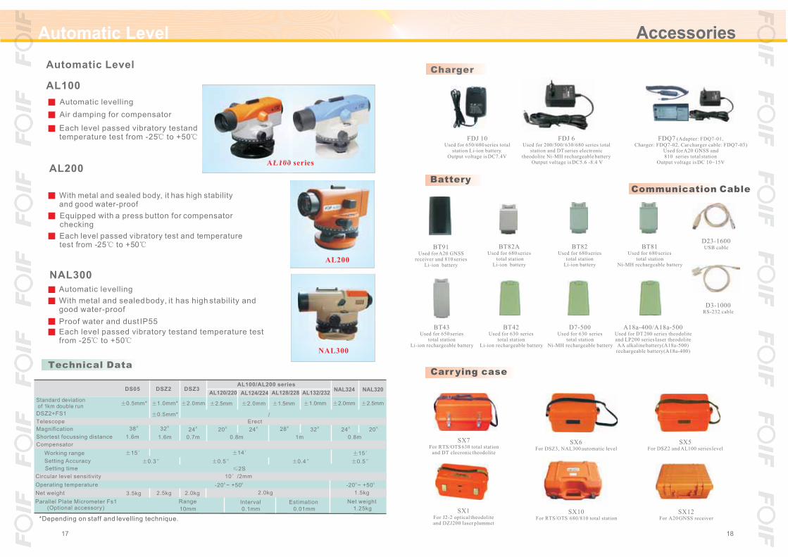
Automatic Level Accessories
A18a-400/A18a-500Used for DT 200 series theodoliteand LP200 series laser theodoliteAA alkaline battery(A18a-500)rechargeable battery(A18a-400)
FDJ 6Used for 200/500/ 630/680 series total
station and DT series electronic theodolite Ni-MH rechargeable battery
Output voltage is DC5.6 -8.4 V
Battery
Carrying case
SX7For RTS/OTS 630 total station
and DT elecronic theodolite
SX1For J2-2 optical theodoliteand DZJ200 laser plummet
SX6For DSZ3, NAL300 automatic level
SX5For DSZ2 and AL100 series level
Charger
BT42Used for 630 series
total stationLi-ion rechargeable battery
1817
SX10For RTS/OTS 680/810 total station
FDQ7 (Adapter: FDQ7-01,
Charger: FDQ7-02, Car charger cable: FDQ7-03)Used for A20 GNSS and810 series total station
Output voltage is DC 10~15V
FDJ 10Used for 650/680 series total
station Li-ion battery.Output voltage is DC7.4V
BT43Used for 650 series
total station Li-ion rechargeable battery
BT91Used for A20 GNSS
receiver and 810 seriesLi-ion battery
BT82AUsed for 680 series
total station Li-ion battery
2.5mm
NAL320
X20
Net weight
o o-20 ~ +50
0.8m
15
1.25kg
1.5kg
AL200
NAL300
2.0mm
NAL324
0.5
X24
AL100 series
AL132/232
1.0mm
X32
Estimation
0.01mm
0.4
1m
AL128/228
1.5mm
AL100/AL200 series
X28
With metal and sealed body, it has high stability and good water-proof
Each level passed vibratory test and temperature test from -25 to +50
/
2.0kg
AL124/224
2.0mm
0.1mm
Interval
Erect
With metal and sealed body, it has high stabilityand good water-proof
Equipped with a press button for compensator checking
Each level passed vibratory test and temperaturetest from -25 to +50
X24
14
10 /2mm
0.8m
o o-20 ~ +50
2S
AL120/220
2.5mm
X20
0.5
Each level passed vibratory test and temperature test from -25 to +50
10mm
Range
2.0mm
DSZ3
0.7m
2.0kg
Air damping for compensator
X24
Proof water and dust IP55
1.0mm*
0.5mm*
DSZ2
X32
1.6m
0.3
2.5kg
Automatic levelling
Automatic levelling
Technical Data
Parallel Plate Micrometer Fs1 (Optional accessory)
Shortest focussing distance
Circular level sensitivity
Operating temperature
Setting Accuracy
Standard deviation of 1km double run
Working range
NAL300
Magnification
Compensator
Setting time
AL200
AL100
Telescope
DSZ2+FS1
Net weight
SX12For A20 GNSS receiver
Communication Cable
D23-1600USB cable
D3-1000RS-232 cable
BT82Used for 680 series
total stationLi-ion battery
Automatic Level
*Depending on staff and levelling technique.
0.5mm*
DS05
X38
1.6m
3.5kg
15
D7-500Used for 630 series
total stationNi-MH rechargeable battery
BT81Used for 680 series
total stationNi-MH rechargeable battery

Refelective prism accessories for total station
RP60(60mm 60mm)
RP30(30mm 30mm)
YGFDQ2BSingle prism system
(0 offset)
YGFDQ2ASingle prism
YGFDQ3Triple prisms system
(0 offset)
Reflective sheet
YGFDQ2ASingle prism system
(0/-30 offset)
Diagonal Eyepiece
FJ19Can be equipped on DT,Level and Total Station
FJ13ACan be equipped on J2-2
theodolite
Three-jaw Tribrach
FJ16 /FJ16DFJ16 without optical plummetFJ16D with optical plummet
FJ21/FJ21DFJ21 without optical plummetFJ21D with optical plummet
FDC9BTribrach adapter with optical plummet
2019
AccessoriesAccessories Accessories
YGFDQ4A L PrismYGFDQ4D
H Wooden Tripod For Theodolite Flat Wing nut
7 H Wooden Tripod For Theodolite 66 02.0 Flat Wing nut 5.8
H Wooden Tripod For Theodolite Flat Quick release
Wooden Tripod For Level Flat Quick r elease
Aluminium Tripod For Theodolite Flat Wing nut
Aluminium Tripod For Theodolite Flat Two clamp mode
Aluminium Tripod For Level Flat Quick release
Wooden Tripod For Level Flat Wing nut
Wooden Tripod For Level Flat Wing nut
Aluminium Tripod For Theodolite Dome Wing nut 4
Aluminium Tripod For Theodolite Flat Quick release
Aluminium Tripod For Level Flat Wing nut
Column
Central
Aluminium Tripod For Rotating laser Flat Wing nut
Weight
YGRJ170
Of head
Inner diameter
Quick release clamp
Wing nut clamp
Of head
Outer diameter
YGM170H
Model No. Description Opened length Closed length Head Clamp mode
Closed parts
YGMJ170H
YGMJ165SC
YGM165HC
Dome head
Flat head
YGLJ165C
Technical Data
YGL165
Tripod
FDC10Tribrach adapter with optical plummet
YGFDQ2A0Single prism(0/-30 offset)
YGFDQ2B0Single prism
(0 offset)
YGFDQ2C0Single prism
(0 offset)
YGFDQ2LSingle prism system
(0 offset)

Accessories Accessories
Technical Data
Prism Poles & Bipods
D3/5m D3/3m D3/2m D2/2m D2-1 D2-2
Standard joint Leica type(left) & Sokkia type(right) Leica type(left) & Topcon type(right)
Name Opened lengthModel
2100mm
Prism poles
Prism poles
Prism poles
Prism poles
Bipods
Bipods
D3/2m
D2/2m
D3/3m
D3/5m
D2-1
D2-2
1360mm
3100mm 1420mm
5100mm 1680mm
1920mm
1920mm
1120mm
Minimum length Joint type Minimum reading
10mm
10mm
10mm
10mm
Equipment ofPoles & Bipods
D2-1 D2-2
D3
D3
D3
D2
D2
Optional:
LEICA
D3/4.6m
Prism poles
2100mm
4700mm 10mm D31580mm
2221
Pole's bag D3
Bipods D3 D2 D3
Serial number
Levelling staff
Levelling staff
Reading model of graduation
Specifications
Figures of mini-reading
3 meters
4 meters
5 meters
5 meters
Length
01
02
03
04
Length
Face side: 10 mm
Back side: 1mm
01
Section amount
Mini-reading
S - X X 0 X
3 sections
4 sections
5 sections
Face side
4 sections
10mm
10mm
10mm
0.1 ft
Back side: 1mm/reading from up to down
overall length
1mm/reading from up to down
2mm
2mm
3mm
Error of
Face side: 10mm
3mm
Reading model of graduation (01 to 04)
Section amount
Back sideMini-reading
02
1 inch
1mm
5mm
Levelling staff
each meter
0.5mm
0.5mm
0.5mm
Error of
0.5mm
Face side: 10mm
Back side: 5mm
03
Aluminium-alloy staff
Back side: 1 inch
Face side: 0.1 ft
Fibre-glass staff(5m, 4 sections,3mm, 0.5mm)
04
Invar staff

Accessories
Surveyor s P oles
Reading mode of graduation
Connection of the pulling stake Connection of the loose joint stake
Name
Loose joint stake
Specifications
JHG 2m
JHG 2.5m
JHG 3m
1mm
Error of each meter At a distance
Loose joint stake
Loose joint stake
Loose joint stake
Pulling type stake I
Pulling type stake I
Pulling type stake I
Pulling type stake I
Pulling type stake II
Pulling type stake II
Pulling type stake II
JHG 5m
CHHG 2m
CHHG 2.5m
CHHG 3m
CHHG 5m
CHHG 2m
CHHG 3m
CHHG 5m
1mm
1mm
1mm
1mm
1mm
1mm
1mm
1mm
1mm
1mm
Error of overall length
2mm
2.5mm
3mm
3mm
2mm
2.5mm
3mm
4mm
2mm
3mm
4mm
2mm
2.5mm
3mm
4mm
0.5mm
0.5mm
0.5mm
0.5mm
2mm
2mm
2mm
23
New Factory
GPS Poles & Tirpods for GNSS Receiver
Quick Lock
Quick Lock
D4-2
D4-1
D4/2A D4/2B for GPSD4/2C for GPS and prism