Embed Size (px)
Citation preview

Options Méditerranéennes, A n° 88, 2009 - Technological Perspectives for Rational Use of Water Resources in the Mediterranean Region
Sustainable management of reservoirs and preservation of water quality
Şahnaz Tiğrek1, Özge Göbelez2 and Tuce Aras1
1 Middle East Technical University, Civil Engineering Department, Hydraulic Lab Ankara, Turkey. 2 Ada HES Engineering, Consultancy Company, Construction Company, Ankara, Turkey.
Abstract. Sustainable development of water structures have been in hot debate for more than a decade. Further sustainable development of water basins or integrated management of water basins are the following ideas. However, after 150 years of dam construction, the number of undeveloped water basins is not too high. Today, we need better tools to manage the basins which have already been developed. In this aspect management of reservoir siltation is a backbone for sustainability of dams and water resources of the respective basin. Therefore, in the present paper the mechanics of reservoir siltation, several alternatives for desiltation process and new research on the topic are discussed. Consequently, a new approach to Sustainable Development of Basin Water Storage Capacity is described.
Keywords. Sediment transport – Reservoir sedimentation – Delta formation.
Gestion durable des réservoirs et préservation de la qualité de l’eau
Résumé. Pendant plus de dix ans, le développement durable des ouvrages hydriques a fait l’objet d’un débat considérable qui a mis en évidence la nécessité de promouvoir un développement plus durable et/ou une gestion intégrée des basins versants. Toutefois, 150 ans après la construction du barrage, le nombre de basins versants sous-développés est peu important. Il est donc nécessaire de mettre au point des outils plus performants pour gérer les basins déjà développés. A cet sujet, la gestion de l’envasement du réservoir est fondamentale pour la durabilité des barrages et des ressources en eau dans le bassin. Par conséquent, dans le présent travail on passée en revue la mécanique de l’envasement du réservoir, les diverses alternatives pour le processus de désenvasement et les nouvelles orientations de la recherche dans ce domaine, pour présenter, enfin, une nouvelle approche de Développement Durable de la Capacité de Stockage de l’Eau de Bassin.
Mots-clés. Transport des sédiments – Sédimentation du réservoir – Formation du delta.
I – IntroductionCivilization is known to have started with the invention of the wheel but the first wall built by men has an undeniable importance, too. Walls have various purposes mainly as separation and conservation. When a high structure which may be simply called as a wall is built right across a river, it prevents the flow of water and forms a reservoir at the upstream. In civilization, these types of structures, i.e. dams, which are designed as more complex walls, are built in order to provide the use of water for life, such as irrigation, domestic uses, hydropower purposes and also for water control during floods etc. In today’s world, when a problem takes place in the operation in time, it is inadmissible to abandon a huge structure without any effort. In technological perspective, while considering the rational use of water, keeping the basin water storage at its original level has great significance. However, siltation prevents the rational usage of basin water storage. The adverse effect of trapping sediment in reservoirs does not only influence the upstream face of the dams but also affect the downstream face of the dams. For a basin near the coast, the continuity of flow of solid particles together with water up until the coastline is very important, because these particles form a delta by being deposited right at the region where the river meets the sea. This influences the conservation of ecology in the downstream negatively. The prevention

42 Options Méditerranéennes A 88
of the continuity of flow of solid particles will help avoiding the downstream delta formation and destructive effects on the downstream face. Since, the water spilled from the spillway is not loaded with solid particles, they have the ability to gain more velocity being unsaturated. Thus, the scour rate will increase at the downstream and the fertility of the downstream plains decreases. Because of these reasons, the most important criterion after the structural stability is sediment transport blockage of reservoirs.
There are 40 000 dams in the world and their number grows steadily. The world records in sediment production measured in arid climate conditions are as high as 6000-8000 m3/km2/year. Every year 0.5-1.0% of the world’s reservoir capacity is lost due to sedimentation (White, 2000).Therefore, sediment data should be included in the design procedure of a reservoir in conjunction with the hydrological data. These data are used in the analysis of operational optimization including the economic life of the reservoir. In Turkey, the economic life of a dam is taken as 50 years, whereas it can change for other countries to 75 or 100 years. In this design approach, only environmental and social issues are included in the initial stage of the project but any change over the operation and maintenance period is not included (Palmieri et al., 2003). This period, which actually depends on sedimentation, should be taken into consideration at the design stage in order to achieve the sustainable development of basin water storage. The sediment accumulation starts firstly along the upstream of reservoir and if no intervention is done at this stage, the sediment transport of the river will be stopped and the reservoir will start to fill up. However, modeling techniques and some precautions and interventions during operation can solve these major problems. As a matter of fact there are three approaches for sustainable development of basin water storage capacity such as preventing sediment inflow, sustainable management of the reservoir and search for new storage alternatives. These techniques should be also considered at the design stage. Today, the World Bank is promoting life cycle management approach. In this approach, sedimentation, decommissioning of the dam, different reservoir sedimentation management alternatives, social and environmental safeguards, economic optimizations for all of the management techniques can be included in pre-feasibility study.
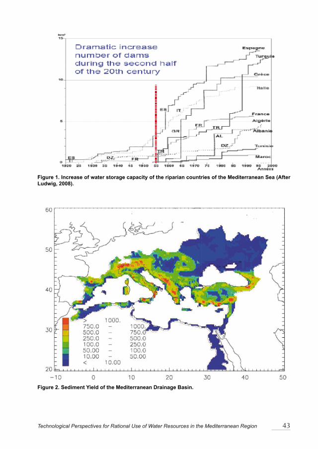
1. Reservoir Siltation in the World and in the Mediterranean Region According to ICOLD, if the height of a dam is higher than 15 m from the foundation or the volume of the reservoir is equal to or more than 3 hm3, the dam is classified as a large dam. Today, there are 45 000 large dams around the world and the largest share with 22 000 of them belong to China. In the Mediterranean Area, Spain is the champion with 1196 dams. Turkey comes second with 625 dams and France ranks third with 566. The life-time of a reservoir depends on several natural factors, among which climatic parameters and geographic – geological factors are the most important. As a matter of fact, these factors determine the sediment production. The world records in sediment production measured in arid climate conditions are as high as 6000 – 8000 m3/km2/year. Table 1 shows the storage, power and sedimentation of the corresponding dams in given areas. Coming specifically to the Mediterranean Region, Ludwig (2008) gives the number of dams in the riparian countries during the second half of the 20th century (Figure 1).
In Figure 2, sediment yield of the Mediterranean Basin can be seen. The Mediterranean drainage basin incorporates more than 160 rivers with a catchment greater than 200 km2, of which only a few are larger than 50 x 103 km2. This observation emphasizes the role of the smaller rivers (Poulus, 2005; Poulus and Collins, 2002). Poulus and Collins (2002) examined 69 rivers out of 169 of the Mediterranean drainage basin and concluded that the construction of hundreds of dams around the Mediterranean Sea, especially over the last 50 years, has led to a dramatic reduction in the sediment supply to approximately 50% of the potential (natural) sediment supply. Such a reduction is considered to be the primary factor responsible for the loss of coastal (mainly deltaic) land, with annual rates of erosion ranging from tens (Ebro, Po) to hundreds of meters (Nile).
Technological Perspectives for Rational Use of Water Resources in the Mediterranean Region 43
Figure 1. Increase of water storage capacity of the riparian countries of the Mediterranean Sea (After Ludwig, 2008).
Figure 2. Sediment Yield of the Mediterranean Drainage Basin.

44 Options Méditerranéennes A 88
Table 1. Worldwide Storage, Power and Sedimentation.
RegionNumber of large dams
Storage (km3)
Total Power (GW)
Hydropower Production in 1995 (TWh/yr)
Annual loss due to sedimentation
(% of residual sto-rage)
Worldwide 45 571 6325 675 2643 0.5 – 1Europe 5497 1083 170 552 0.17 – 0.2North America 7205 1845 140 658 0.2South and Central America 1498 1039 120 575 0.1North Africa 280 188 4.5 14 0.08 – 1.5Sub Saharian Africa 966 575 16 48 0.23Middle East 895 224 14.5 57 1.5Asia (excluding China) 7230 861 145 534 0.3 – 1.0China 22 000 510 65 205 2.3Source: RESCON Manual Volume I, 2003, After White, 2000
2. Siltation of Turkey’s damsThe diversity in the topography brings diversity in the climate of Turkey like many other Mediterranean Countries. As a result, large variations in precipitation take place. The average annual precipitation depth in Turkey is around 643 mm, which is lower than 800 mm, the average precipitation depth of the world (Usul, 2005). Inner Anatolia and East Anatolia receive heavy snow in winter. The annual flows of many of the large basins have a trend of fluctuation. Nearly every 30 years, a drought period takes place. However, the periods between these drought seasons have shortened after 1960. The last drought was in 1994 and lasted five years (Komuscu et al., 2005). Average annual surface water in Turkey is 193 billion m3 and groundwater is 41 billion m3. The total amount of exploitable surface water is 110 billion m3 and groundwater safe yield is 12 billion m3. The quantity of water per capita is around 1700 m3/year for a population of 67.8 millions. Today, Turkey utilizes only 39.3 billion m3 of its capacity. However, it is expected that in 2030, the amount of available water per capita will be less than 1000 m3 per year. As a result, dam construction in Turkey will continue although there are 555 large ones already built up. The first dam built in Turkey during the Republic Era is Cubuk I Dam, completed in 1936, built for the domestic water requirement of the city of Ankara. After the second World War, an increase in construction of dams and hydroelectric power plants could be observed in Turkey. The state constructed more than 1000 dams and most of the rivers were taken under control. Most of these dams have reservoir volume smaller than 100 hm3, and their technical accessories are simpler than in the large dams. Consequently, they are even endangered by siltation. The specific sediment-yield of the watersheds in mountainous areas of Turkey where the most dams are and will be constructed is considerably high.
3. Literature Review for TurkeyFakioglu (2005) studied Seyhan Dam which is located in Seyhan Basin, near the Mediterranean Sea. In this study, the author has evaluated the sediment yield by comparing the hydrographical maps produced in different periods and considered the causes of sedimentation and countermeasures accordingly. It is found out that the active volume of the reservoir was 1238 hm3 in 1966 and has decreased to 831 hm3 until 2005. Also, the accumulated sediment volume was 407 hm3 in 2005.
Another case study on the effect of flow change and sediment transport on the river bed scour downstream is made by Işık et al., 2005. Sediment rating curves in Lower Sakarya River are

Technological Perspectives for Rational Use of Water Resources in the Mediterranean Region 45
determined and compared by using measured suspended load before and after the construction of Gökçekaya Dam in the Middle Sakarya Basin. It was observed that the sediment transport decreased at a rate of 40-65% after the construction of Gökçekaya Dam and consequently, the comparison of cross section measurements in 1965 and 2003 pointed out an enlargement in the width and a scour up to 7 m in the depth of the river.
A case study on Kızılırmak Basin (located nearby the Black Sea, also the third largest basin of Turkey) shows that 12 important dams on Kizilirmak River (İmranlı, Yamula, Bayramhacılı, Hirfanlı Kesikkopru, Kapulukaya, Bura, Obruk, Dutludere, Boyabat, Altınkaya and Derbent Dams), which were built with the aim of energy, flood control and irrigation, have been trapping the alluvium; therefore, the solid material reaching the coastline has decreased by 98%. This has resulted in a decrease or even a stop in the increase rate of the delta; the coastal stream and waves cause erosion of delta. A numeric illustration for the second consequence is studied by many authors. Guler et al. (2002) points out that the yearly setback is around 30 m and Kokpinar et al. (2000) gives the total number between 1990 – 2000 as 1 km back.
Although there are significant environmental effects, siltation starts to appear under the coastline of the Black Sea after 50 years of dam construction; the design life approach is being used in the design stage of new dams. There are limited studies about reservoir siltation, focusing on the design life of the dam (Yalcinkaya, 1991; Yilmaz, 2005; Yilmaz et al., 2005). Sonmez and Dincsoy (2002) prepared a report for the determination of annual sediment yield and possible precautions for Ivriz Dam, which is located in the Central Anatolia, by using Geographical Information System (GIS).
4. Siltation mechanism Nevertheless, in order to understand the complex mechanism and to find a universal solution, both experimental and numerical studies by hydraulic engineers are needed. The main problem in modeling desiltation is the determination of the particles’ motion behavior. Fan and Morris (1992) divide the principal sedimentation into three categories: the deltaic deposition of primarily coarse materials; deposition of fine sediments from homogenous material; and transportation and deposition of fine sediment from stratified flow.
Coarser particles deposit mostly at the entrance of the reservoir forming a delta as shown in Figure 3. Deposited coarser sediment materials at the upstream reach of a reservoir will cause the water level to rise during flood time; spillway capacity will be overloaded. Delta formation is modeled by using available semi-empirical sediment transport equations for the river flow (Pulcuoglu, 2008). This kind of models can be useful for saving time while calculating and comparing several approaches of sediment load carried by a river and its accumulation profile. The profile of accumulation is also very useful for the location of intake structures in reservoirs since any sediment particles cause great harm to the intake structures, pipes, turbines, gates of hydropower equipment or irrigation systems, etc.
The state of flow after delta is a quasi-homogeneous flow. Since water within the reservoir has a lower density than the incoming flow which carries sediment, the flow becomes gradually stratified and plunges into the bottom. The plunge point may migrate forward. Lee and Yu (1997) reported a limiting value of densimetric Froude number for plunge. Then, density current or gravity currents occur. Due to their turbulence, they are generally called turbidity currents. Turbidity currents are accepted to be the governing process in reservoir sedimentation (De Cesare et al., 2001). They move sediment further towards the dam body. If there is an outlet on the dam body facing turbidity currents, sediment can continue its voyage (outlet B in Figure 3). Otherwise, sediment is gradually deposited on the bed... this condition reduces their capacity over time; consequently, replacement of storage becomes necessary. On the other hand, finer sediment is carried by quasi-homogeneous flow to nearer parts of the body of a dam (Yu et al., 2004). A muddy lake

46 Options Méditerranéennes A 88
eventually forms and deposits sediments which decrease the storage capacity of the reservoir and also reduces sediment supply into downstream river. In stably stratified reservoir, selective withdrawal is accomplished by placing slit or slot outlets at different levels. An outlet at the upper layer (outlet C in Figure 3) for intake to the turbines or water supply takes clear water. At this process, initiation of muddy lake is an undesired situation. In some situations, dam is abandoned due to sedimentation even if it is not completely silted. Sediment accumulation in the dead volume of a dam after a certain time may interfere with the operation of bottom outlets (outlet A in Figure 3). On the other hand, sediment accumulation in the active volume will reduce the useful storage of reservoir and the water stored in reservoir will not be sufficient for intended purposes.
Muddy Bottom Outlet A
Delta
Turbidity Currents
Outlet B
Outlet C Plunge point
Figure 3. Typical reservoir cross section.
Majority of selective withdrawal experiments are made with brine and fresh water because sand particles may create unsteadiness in the flow. There are also many studies on the initiation of motion of sediment starting from the beginning of the last century. The most commonly used chart is plotted by Shields (1936). This chart could not have been replaced because it is entirely empirical, but many developments are made and many points are added to the plot by many researchers, e.g. Vanoni (1964), White (2000), Mantz (1977) and others.
As mentioned before, initiation of motion of sediment particles has been studied by many researchers among which Shields plotted a band in a dimensionless chart. On this plot, the band is assumed to be region where the motion starts; therefore, above this band, the motion is assumed to be started already, whereas the below region means that the particles do not move. But the most important property of this diagram is the assumption of logarithmic law of velocity distribution because all of the experiments are accomplished under open channel flow conditions. Gobelez (2008) made several experiments on the initiation of motion using sand particles in a model reservoir. This study gives an idea about the conditions of flow at the threshold of motion of particles. A further experimental study on the quantity of transported material is needed for the desiltation procedure. These studies can serve in the purpose of design of bottom outlets of dams. The properties of the outlet directly influence the flow conditions (Cobanoglu, 2008). Furthermore, the flow pattern within the reservoir and concentration of sediment is to be measured by advanced measurement techniques such as Particle Image Velocimeter (PIV) in the laboratory conditions. Additionally, the amount of sediment which is carried out will be measured. This kind of studies can result to get realistic entrainment rate of sediment. Then, the amount of total transported sediment as a function of flow properties and outlet dimensions can be obtained.
Figure 4 reports a sample measurement to visualize the streamlines of the flow in a model reservoir which has a one outlet (Gobelez, 2008; Yilmaz and Tigrek, 2007)

Technological Perspectives for Rational Use of Water Resources in the Mediterranean Region 47
Figure 4. A sample measurement visualizing streamlines in a reservoir when bottom outlet is open.
5. Sustainable Development of Basin Water Storage CapacityWater has a vital importance for human being for the purposes of basic needs such as drinking and providing hygiene. In addition, water provides agricultural and industrial development, hydropower generation, navigation and ecosystem conservation; therefore, water also provides development. However, the amount of fresh water is limited and also qualified resources are not sufficient for the increasing human population. Thus, the existing water resources should be managed properly to fulfill the needs of human beings and to reach the developed country level as well. In other words, the water resources should be used in a sustainable manner; that “use and discard” philosophy should no longer be followed.
The concept of Sustainable Development is defined as “development that meets the needs of the present without compromising the ability of the future generations to meet their own needs” by the World Commission on Environment and Development in 1987 (Tortajada, 2001). In addition, for the water-based development projects the concept of sustainable development includes determination and planning of the demands for the water through the project region, rational water use, participation of the stakeholders, equitable development for human development, achievement of the environmental and social protection by a sensible economic growth, comprehensive observation and assessment, effective supervision and provision of the necessary conditions for the protection of water related structures (Tortajada, 2001). Sustainable development in water is actually accomplished by using the basin water storage capacity in a sustainable manner. This object is called “Sustainable Development of Basin Water Storage Capacity”. In order to attain “Sustainable Development of Basin Water Storage Capacity”, three courses should be followed such as Preventing Sediment Inflow, Sustainable Management of the Reservoir and Search Lost Storage Replacement or Decommissioning of Dam.
Preventing Sediment Inflow can be applied by Watershed Management, Upstream Check Structures (Debris Dams) and Reservoir Bypass.
– Watershed Management. Watershed management is a method which is used to reduce the reservoir siltation coming from the upstream basin of the reservoir by using some techniques such as forestation, prevention of erosion by vegetation and tillage management, sediment trap and change in land usage. As a matter of fact, watershed management aims to conserve soil and consequently conserve water. In order to achieve this aim, techniques should be combined efficiently. However, especially in semi-arid regions it is impossible to manage the watershed effectively.

48 Options Méditerranéennes A 88
– Upstream Check Structures (Debris Dams). Debris dams are relatively smaller dams than the main dam provided by spillway structures. Their function is to stop the main sediment coming from tributaries to the reservoir of a dam which will be used to supply either power or water. It can extend the life of the dam but the debris dam itself will require reservoir sediment management program.
From the economic viability point of view, short lifetime and relatively high cost of debris dams are a problem. Sediment concentration of tributary conversely affects the lifetime of debris dam. This means that if sediment concentration in the tributary is large, lifetime of the dam is short. In addition, debris dams are not active in design flood reduction. The cost of a debris dam is another problem, since a debris dam implies the construction of a dam, of auxiliary structures and the foundation treatment. Increasing the main dam capacity weighed against debris dam capacity is more economical and useful than building a new additional dam.
However, if accumulated sediment in the debris dam is used for construction purposes, like roadway constructions etc., debris dams’ usage will be cost effective by making arrangements at institutional level.
– Reservoir Bypass. Reservoir bypassing is to let the sediment-laden flow pass from a channel, meanwhile keeping the sediment-free water.
Actually, reservoir bypass system is very hard to apply. First of all, it should be designed correctly and operation should be planned carefully since it is a very expensive system. As a matter of fact in order get a feasible Bypass System, some special conditions should be provided at the same time. For example, topography conditions and size distribution of sediment load are very important factors that should be bewared.
Furthermore, bypassing sediment-laden water from channel is not acceptable for arid areas where water is really needed.
Sustainable Management of the Reservoir can be achieved by Evacuation of Sediments from Reservoir and Management of Reservoir.
– Evacuation of Sediments from Reservoir
– Flushing: Flushing is a sediment removal technique by which the deposited sediment is scoured from the reservoir by increasing flow velocity and then transported through low level outlets. Flushing can be operated in two ways such as by lowering water level or without lowering water level, called “flushing under pressure” and “free-flow flushing” respectively. Flushing under pressure is to release water through the bottom outlets by keeping reservoir water level high. On the other hand, free-flow flushing releases water by emptying the reservoir and also routes inflowing water from upstream by providing riverine conditions (Morris & Fan, 1998). For semi-arid regions, “flushing under pressure” applicability is suitable because of water scarce.
Another categorizing of flushing is done again by Fan & Morris and summarized in Table 2.

Technological Perspectives for Rational Use of Water Resources in the Mediterranean Region 49
Tabl
e 2.
Typ
es o
f flus
hing
.
Se
dim
ent d
isch
arge
(2)
Ope
ratin
g ru
le (3
)O
utle
t typ
e (4
)M
ode
of a
ctio
n (5
)A
dvan
tage
s an
d di
sadv
anta
ges
(6)
Sed
imen
t rou
ting
durin
g flo
ods
Dis
char
ge <
inflo
w:
Sed
imen
tatio
n ra
te s
igni
fican
tly
redu
ced
if hy
drau
lic d
eten
tion
time
is g
reat
ly re
duce
d du
ring
sedi
men
t dis
char
ge e
vent
s
Out
lets
ope
ned
as e
arly
as
pos
sibl
e, o
r res
ervo
ir le
vel r
emai
ns s
easo
nally
lo
w, t
o m
inim
ize
stor
age
durin
g se
dim
ent-l
aden
flo
od p
erio
ds
Low
-leve
l out
let
requ
ired
to a
chie
ve
sign
ifica
nt re
duct
ion
in
rese
rvoi
r poo
l lev
el
Impe
de d
epos
ition
of
slow
ly s
ettin
g si
lt an
d cl
ay
parti
cles
by
min
imiz
ing
dete
ntio
n pe
riod
Use
ful a
t man
y ty
pes
of
site
s. C
an u
tiliz
e ex
cess
w
ater
dur
ing
flood
s fo
r se
dim
ent c
ontro
l; ca
nnot
sto
p se
dim
enta
tion
Dra
wdo
wn
flush
ing
Dis
char
ge >
inflo
w:
Und
er fa
vora
ble
circ
umst
ance
s se
dim
ent a
ccum
ulat
ion
can
be
arre
sted
Out
lets
ope
ned
as e
arly
as
pos
sibl
e to
cre
ate
rapi
d flo
w th
roug
h re
serv
oir
durin
g ris
ing
limb
of fl
ood
Bot
tom
out
lets
ca
pabl
e of
dis
char
ging
se
dim
ent-l
aden
floo
d flo
w w
ith m
inim
um
back
wat
er
Turb
ulen
t flow
mai
ntai
ns
sedi
men
t in
susp
ensi
on,
and
can
rem
obili
ze s
ome
prev
ious
ly d
epos
ited
sedi
men
ts b
y er
osio
n
Und
er p
rope
r con
ditio
ns,
capa
ble
of a
rres
ting
sedi
men
tatio
n.
Em
ptyi
ng &
Fl
ushi
ng
Dis
char
ge >
inflo
w:
Und
er fa
vora
ble
cond
ition
s,
sedi
men
t acc
umul
atio
n ca
n be
ar
rest
ed a
nd lo
st c
apac
ity c
an
be re
gain
ed b
y er
osio
n
Res
ervo
ir em
pty
durin
g flo
od s
easo
n to
per
mit
scou
r of s
edim
ent
depo
sits
by
flood
s
Bot
tom
out
lets
requ
ired
to p
erm
it re
serv
oir
to b
e dr
aine
d; o
utle
t ca
paci
ty m
ay b
e le
ss
than
the
flood
flow
Turb
ulen
t flow
mai
ntai
ns
sedi
men
t in
susp
ensi
on,
and
som
e se
dim
ent
depo
sits
rem
oved
by
retro
gres
sive
ero
sion
The
only
stra
tegy
whi
ch
can
reco
ver l
ost c
apac
ity,
but i
t req
uire
s em
ptyi
ng th
e re
serv
oir o
n a
regu
lar b
asis
Vent
ing
Den
sity
C
urre
nt
Dis
char
ge <
inflo
w:
Und
er s
peci
al c
ircum
stan
ces,
ac
cum
ulat
ion
of fi
ne s
edim
ents
ca
n be
sig
nific
antly
redu
ced
Ope
n bo
ttom
ven
ts w
hen
dens
ity c
urre
nt re
ache
s da
m s
ite; w
ater
leve
l dr
aw-d
own
not r
equi
red
Low
ele
vatio
n bo
ttom
ou
tlets
of m
oder
ate
capa
city
to m
inim
ize
back
wat
er o
f mud
dy
flow
A po
rtion
of t
he d
ensi
ty
curr
ent c
onta
inin
g si
lt an
d cl
ay is
ven
ted
Doe
s no
t req
uire
dra
wdo
wn
of re
serv
oir p
ool l
evel

50 Options Méditerranéennes A 88
Sluicing: Sediment sluicing is an operational design. In most cases the reservoir is drawn down in flood season and then sediment carrying inflow directly passes through the reservoir. The sediment has no chance to settle down. After flood season the clear water will be stored and reservoir will be raised for the next season usage. In the worldwide usage, generally sluicing and flushing are used together.
Density Current Venting: Density current venting means to route the sediment-laden flow through the stored water in the reservoir. In order to have successful density current venting, the incoming sediment-laden flow would have enough velocity and fine particles to form turbid flow. If these favorable conditions are got, current should be able to reach dam. At this time the bottom outlet will be opened and the current will be vented through. In this method, it is not necessary to decrease the reservoir water level contrary to flushing or sluicing.
Mechanical Removal
Dredging: Dredging is the mechanical removal of accumulated sediment in the reservoir from a reservoir bed by pumping (traditional hydraulic dredging) or by mechanical equipment without emptying the reservoir and then dumping the dredged sediment at a suitable area. Dredging method is suitable for medium- and small-sized reservoirs, which do not have enough water for flushing.
Trucking: Trucking is the excavation of the accumulated sediment from a reservoir like dredging but it requires the drawdown of the reservoir. Then the excavated sediment is transported to a suitable disposal area by using traditional earth moving equipment. Cost of drawdown, transportation cost and suitable area cost make the method very expensive. This is why trucking is not widely used.
HSRS: Hydrosuction Removal System (HSRS) is similar to traditional hydraulic dredging and it is simply a siphon and airlift system, which uses the potential energy stored by the hydraulic head at the dam, removes the sediments through a floating or submerged pipeline to an outlet. This system is named Hydrosuction Removal System (HSRS) and Sediment Evacuation Pipeline System (SEPS) in the USA, Geolidro System in Italy. This method has some advantages with respect to traditional dredging. For example, since potential energy stored by hydraulic head is used there is no need for any equipment to produce energy. Therefore, the operating costs are substantially lower than those of traditional dredging. In addition, finding suitable disposal site is not needed in HSRS, because sediment goes to the downstream end of the reservoir, which is also environment friendly. The reason to use this technique is the lack of water for flushing. The released water and sediment can be used for irrigation.
6. Management of ReservoirOperational Rules. The reservoir operating rule can effect how the sediment deposition occurs. For example, during flood season if reservoir water level is high, the sediment is mostly deposited in the upper reaches of the reservoir. On the contrary, during flood season if the reservoir is drawn down, the sediments tend to deposit in the dead storage zone of the reservoir.
Tactical Dredging: Tactical dredging is the same as traditional dredging; the difference is to remove accumulated sediment in the reservoir locally. For example, in hydropower dams it is important to keep the vicinity of the outlets clear. If the outlets of the reservoir get blocked, the hydropower production will stop. In addition, the mechanical equipment like turbines used to produce energy will be damaged because of sediments. Therefore, by tactical dredging the useful life of the reservoir will decrease, also operation and maintenance costs will increase unexpectedly. It is understood that localized dredging can be an effective tool to prolong the reservoir life.

Technological Perspectives for Rational Use of Water Resources in the Mediterranean Region 51
7. Search Lost Storage Replacement or Decommissioning of DamRaising Dam Height. Raising dam height is to increase the reservoir capacity in order to compensate the storage loss due to sedimentation. Especially in arid regions raising should be seen as a cost-effective method. Nevermore, in the long term period it is not a solution for sediment problem. In addition this method requires very careful engineering.
Building New Dam. In order to replace the storage lost of an existing dam, a new dam can be built downstream or upstream of the existing reservoir or on another river. Generally, in Turkey it is used this to replace the lost storage capacity but it is a temporary solution.
Decommissioning (Retirement of Dam). Decommissioning is removing all the structures of a dam project so as to end the operational life of a dam. Decommissioning of a dam is not a reservoir sediment technique; on the contrary it is an economic option if the dam useful life is finished. In other words, if operation costs of the reservoir are higher than the benefits gained from the reservoir, decommissioning is an economic option for further actions.
Aras (2008) and Cetinkaya (2006) studied the economic aspects of the sustainable development of basin water storage capacity. In this study, the methods that provide extension of reservoir life are discussed from the hydraulic, economic and applicability point of view. In addition, an already existing, free of charge, program RESCON, which examines and compares some sediment evacuation methods and decommissioning, economically and also hydraulically, is used. Moreover, some sensitivity analyses are presented and construed for Turkey Dams to understand the program suitability under Turkish conditions. RESCON is a spreadsheet-based program written in Visual Basic programming language and works with macros. There are two pages to input the required data. There are eight types of data the user should input for the program RESCON in these two pages. These are as follows: Reservoir Geometry, Water Characteristics, Sediment Characteristics and Removal Parameters, Economic Parameters, Flushing Benefits Parameters, Capital Investment, and Environmental Parameters.
II – Discussion and ConclusionThe need of hydraulic structures for energy, flood control, and irrigation purposes will always take place as long as civilization continues. The design and construction of hydraulic structures control not only the rivers, but also the solid particles naturally carried by streams. Especially, large dams are the subject of many studies in this area. This is because their large bodies cause huge problems. When sediment particles are trapped by the construction of a body on the river bed, the transport process stays incomplete which is observed as the decrease or stop in formation of deltas. Also the trapped particles reduce the active volume of the reservoirs. Most of the time, the nature may not be calculated sensitively with math and science. Therefore, all design and optimization procedures of hydraulic structures may not serve in the most efficient way in the economic life of them. In order to provide a sustainable future for both nature and man-made structures, many researchers study today both the determination of the problems and their solutions. For determination of problem, different GIS and manual observation techniques on the river morphology and evaluation methods for these observation data are being studied. For the solution of the problem, the trapping effect of the large hydraulic structure and solutions for the removal of trapped particles to continue the transport process are being studied.
The perverse effect of trapping sediment in reservoirs is observed both on the downstream ecology of the river, and on the active volume of the reservoir. The consequences of sediment problems can not be observed in short time interval such as hours or days. The large dams are designed to be filled up in nearly 50 years. Consequently, it takes months and years for a coastline to backset because of the loss of material to be supplied by the river. In order to cope with this problem, careful observation and determination of effective parameters is very important. There

52 Options Méditerranéennes A 88
are studies based on GIS and other manual observation methods to determine the changes in the river morphology. Likewise, many solution methods are also studied as discussed above. Dams are large bodies affecting the nature seriously; therefore in designing such a structure, many aspects should be considered because they cannot be treated easily when a problem takes place when it is in operation. When the first dam is built on a river, the problem of accumulation of sediment particles has begun. There are several ways to avoid the problem but the procedure starts with the well understanding of the complete process. Many computer programs together with model experiments have been and are still being studied for this purpose. But in addition to the massive laboratory works done, the experiences in the world should also be taken into account while developing and comparing methods. Also whatever the protection and the solution method is, the economic optimization is the most important criterion in engineering applications.
ReferencesAras T., 2008. Cost Prediction of Sedımentatıon Removal From Reservoir, Ms Thesis, Dept. of Civil
Engineering, Hydromechanics Laboratory, Middle East Technical University, Ankara, METU. Cetinkaya O.K., 2006. Reservoır Sedımentatıon And Reservoir Conservatıon Case Studıes From Turkey,
Ms Thesis, Dept. of Civil Engineering, Hydromechanics Laboratory, Middle East Technical University, Ankara, METU.
Cobanoglu I., 2008. Experımental Study Of Sıngle And Multıple Outlets Under Constant Head, Ms Thesis, Dept. of Civil Engineering, Hydromechanics Laboratory, Middle East Technical University, Ankara, METU.
De Cesare G., Schless A. and Hermann F., 2001. F. Impact of Turbidity Currents on Reservoir Sedimentation. Journal of Hydraulic Engineering 127(1), 6-16.
Göbelez Ö., 2008. Experimental Analysis of the Flow Through a Bottom Outlet on the Threshold of Motion of Particles. Ms Thesis, Dept. of Civil Engineering, Hydromechanics Laboratory, Middle East Technical University, Ankara, METU.
Güler I., Drama Y., and Kökpınar M.A., 2002. Kızılırmak Ağzı Kıyı Çizgisi Degisimi, 4. Kıyı Mühendisliği Ulusal Sempozyumu Bildiriler Kitabı, Cilt: 2, s. 713-730, Antalya.
Isik S., Sasal M. and Dogan E., 2005. Investigation of Downstream Effects of Damsin the Sakarya River, J. of Fac. Eng. Arc. Gazi University. Vol. 21, No 3, pp 401-408.
Kokpinar M.A., Guler I. and Darama Y., 2000. Bafra Ovası Kizilirmak-Karadeniz Birleşimindeki Kıyı Erozyonunun İncelenmesi. III. Ulusal Kıyı Muhendisligi Sempozyumu, s. 507-524, Canakkale.
Komuscu A.U., Erkan A. and Turgu E., 2005. Normalleştirilmiş Yagis Indeksi Metodu (SPI) ile Turkiye’de Kuraklik Oluşumunun Cografik Analizi. http://www.meteor.gov.tr/2005/arastirma/dogalafetler/kuraklik.htm
Lee H.Y. and Yu W.S., 1997. Experimental Study of Reservoir Turbidity Current, Journal of Hydraulic Engineering, 123 (6), 520-528.
Ludwig W., 2008. http://www.cnrm.meteo.fr/hymex/global/documents/Presentations_janvier_2007/Session _E/Rivers_input_Ludwig_Wolfgang.pdf
Mantz P. A., 1997. Incipient Transport of Fine Grains and Flakes by Fluids-Extended Shields Diagram. Journal of Hydraulic Division, Proceedings of ASCE 103 (HY6), 601-615.
Palmieri A., Shah, F., Annandale G.W. and Dinar A., 2003. Reservoir Conservation, Volume I: The RESCON Approach. The World Bank, Washington DC, USA.
Paul T.C. and Dhillon G.S., 1988. Sluice Dimensioning for Desilting Reservoirs. Power and Dam Construction, May 1988.
Poulos S., 2005. Modern Fluvial Water And Sediment Fluxes In The Mediterranean And Black Sea Basıns: A Comparison http://www.cosis.net/abstracts/EGU04/07611/EGU04-A-07611.pdf
Poulos S.E. and Collins M.B., 2002. Fluviatile sediment fluxes to the Mediterranean Sea: a quantitative approach and the influence of dams, Geological Society, London, Special Publications; 2002; v. 191; p. 227-245.
Pulcuoglu B., 2008. Prediction of Bed Load Deposition In Reservoirs, Ms Thesis, Dept. of Civil Engineering, Hydromechanics Laboratory, Middle East Technical University, Ankara, METU.
Shields A., 1936. “Anwendung der Aehnlichkeitsmechanik und der Turbulenzforchung auf die Geschiebebewegung.” Mitteilungen der Preusssiischen Versuchsanstalt für Wasserbau and Schiffhau,

Technological Perspectives for Rational Use of Water Resources in the Mediterranean Region 53
Heft 26, Berlin, Germany (in German), (English translation by W. P. Ott and J. C. van Uchelen available as Hydromechanics Lab., California Inst. of Tech., Pasadena).
Tortajada C., 2001. “Environmental Sustainability of Water Projects” Doctoral Thesis Royal Institute of Technology , Stockholm, 2001.
Vanoni V.A., 1964. Sedimentation engineering, the ASCE Task Committee for the Preparation of the Manual on Sedimentation of the Sedimentation Committee of the Hydraulics Division, New York : The Society, 1964.
White W.R., 2000. Contributing Paper: Flushing of Sediments from Reservoirs,. prepared for Thematic Review IV.5: Operation, Monitoring and Decommissioning of Dams. HR Wallingford, UK.
Yılmaz B. and Tigrek S., 2007. Modeling of sediment flushing from reservoirs, HYDRO 2007, Granada, Spain.
Yılmaz C., 2005. Kızılırmak Deltasında Meydana Gelen Erozyonun Coğrafi Analizi, Türkiye Kuvaterner Sempozyumu, sayfa 227-234.
Yu W.S., Hsu S. M. and Fan K.L., 2004. Experiments on Selective Withdrawal of Codirectional Two Layer Flow through a Line Sink. Journal of Hydraulic Engineering, ASCE 130, (12), 1156-1166.