Embed Size (px)
Citation preview
Susceptibility of catchments to INTense RAinfall and flooding (Project SINATRA)
Track Record We assemble a multidisciplinary team of world-leading experts from academia, industry, and government to advance scientific understanding of the drivers, thresholds, and impacts of flooding from intense rainfall in ‘at-risk’ catchments and to translate this small-scale process understanding into new open source model architectures and parameterisations to enable the development of decision-support tools, improving the capacity of forecasting agencies to deliver impacts-based warnings and predictions needed for managing Flooding From Intense Rainfall (FFIR).
Project Director Dr Hannah CLOKE is Reader in Hydrology at the University of Reading. An expert in flood modelling with a 15 year track record spanning basic research, tool development for operational forecasting and policy engagement, she has successfully led several major research projects involving multi-institutional consortia. Her NERC Flood Risk from Extreme Events (FREE) project involved 3 Universities, the Environment Agency and Met Office Hadley Centre to quantify the full cascade of uncertainties in coupled climate-hydrological model predictions of future flood risk, while a BIS-funded UK-China international consortium project involved several industrial partners in the development of a commercial prototype for a multi-ensemble probabilistic flood warning system. She is currently leading the flood forecasting package of NERC Storm Risk Mitigation project DEMON. She played an integral role in the early development of the European Flood Awareness System (EFAS) and has worked as an expert for the Environment Agency, with Halcrow Ltd, to develop a decision-support to enable operational use of probabilistic forecasts.
The Institutions The consortium is led by University of Reading (UoR), which offers a wealth of experience leading NERC research, with 226 NERC grants worth >£48m since 2000. Its Department of Meteorology is Europe’s largest and was the highest rated department focusing on the fundamental science of weather, climate and oceanography in the 2008 RAE, while the Aquatic Environments Research Centre in the Department of Geography and Environmental Science was highlighted as a world-leading centre for integrated catchment hydrological research in RAE 2008.
Newcastle University (UNEW) and the School of Civil Engineering and Geosciences (CEG) were in the top 3 civil engineering schools in the 2008 RAE and have a distinguished track record of RCUK-funded research: advancing stochastic space-time modelling of rainfall extremes, investigating trends and changes in UK rainfall extremes (including convective extremes) and their relation to flood risk, probabilistic methods in climate scenarios, and impacts on drought and flood risk. UNEW were a partner in both phases of the recent EPSRC Flood Risk Management Research Consortium (FRMRC), had two projects in NERC FREE and many funded flood risk projects for DEFRA, including FD2114. The University of Bristol (UoB) led FRMRC and FRMRC2 and has been involved in all significant flood research consortium projects over the last decade. UoB has the only UK geography department to have been in the top category in every national research assessment exercise, and the UoB Hydrology Group is internationally recognized for hydrological model development (e.g. LISFLOOD-FP, Dynamic TOPMODEL etc). The Hazards & Risk Group at King’s College London (KCL) combines natural and social scientific expertise on risk assessment, communication and governance, with members playing leading roles in the Cabinet Office’s Natural Hazards Partnership, the ongoing review for the Chief Scientist of Future Disaster Anticipation and Resilience, and as immediate past president of the EGU’s Natural Hazards Division. The Centre for Water Systems (CWS) at the University of Exeter (UoE) has a 15-year history of applying cross-disciplinary expertise in hydraulics and numerical modelling to address practical problems of urban drainage and flooding in Europe and the developing world. The Department of Geography, University of Hull (UoH) has an established track record of research in fluvial geomorphology and flow dynamics, which saw it lead the independent review of the June 2007 floods in Hull.
These academic partners are joined by a number of leading public sector research establishments, including the UK Met Office (UKMO) and their joint Flood Forecasting Centre (with the Environment Agency), who are the national weather service and world leader in weather and climate services; British Geological Survey (BGS), which provides SINATRA with access to unique datasets on groundwater flooding; and the Health and Safety Laboratory (HSL), which supports the Health & Safety Executive and other organisations with risk assessment and hazard

Susceptibility of Catchments to Intense Rainfall and Flooding (SINATRA)
2
control services (including in relation to flood risk and associated hazards). Their work is coordinated through the Cabinet Office’s Natural Hazards Partnership (NHP), the leading source across government for analysis of natural hazards.
The SINATRA consortium also includes two leading private sector industrial partners, Halcrow and JBA, who are at the forefront of applied research for flood forecasting, risk assessment and management. In addition to their track record of customer-focused research, they also bring valuable experience of designing and delivering decision-support tools for operational application.
The team Team members have a long and distinguished track record of delivering leading edge flood science, having served as PI or Co-I on 47 separate RCUK research grants worth >£25 million, including research under NERC FREE, Changing Water Cycle (CWC), Storm Risk Management, PURE, and EPSRC FRMRC1&2. Significant work in this area has also been undertaken for the UK Met Office and Environment Agency R&D and DEFRA. Together, they offer the full range of disciplinary expertise necessary to improve understanding of the complex processes leading to flooding from intense rainfall, to model its incidence and impacts, and to translate that knowledge into practical tools to improve operational forecasting and flood risk management.
Hydroclimatology: Expertise in quantifying the links between atmospheric circulation patterns, extreme rainfall and flooding in the UK, recent trends in extreme rainfall and future projections, including for convective extremes from the CWC CONVEX project (Prof Hayley FOWLER) and in understanding the underpinning physical processes behind changes in the global water cycle including extreme rainfall (Dr Richard ALLAN) and responses in extreme rainfall to climate change globally (NERC PREPARE project and CWC PAGODA and HydEF projects). They have a strong track record in funding from NERC, EPSRC, EU FP6 and FP7, Defra and EA and collaborative links with the UK Met Office NWP and climate model development, and evaluation and contributions to the IPCC. FOWLER HJ and Wilby RL (2010) Detecting changes in seasonal precipitation extremes using regional climate model projections: Implications for managing fluvial flood risk. Water Resources Research, 46, W03525, doi:10.1029/2008WR007636.
Lavers, DA., ALLAN RP, Wood EF, Villarini G, Brayshaw DJ and Wade AJ (2011) Winter floods in Britain are connected to atmospheric rivers, Geophys. Res. Lett. , 38, L23803, doi: 10.1029/2011GL049783, ALLAN RP (2012) Regime dependent changes in global precipitation. Climate Dynamics. 39, 827-840 10.1007/s00382-011-1134-x
Chan SC, Kendon EJ, FOWLER HJ, Blenkinsop S, Ferro CAT, Stephenson DB (in press) Does increasing the spatial resolution of a regional climate
model improve the simulated daily precipitation? Climate Dynamics.
FOWLER HJ, Kilsby CG (2003) Implications of changes in seasonal and annual extreme rainfall. Geophysical Research Letters, 30(13), 1720,
doi:10.1029/2003GL017327.
Data assimilation: Expertise in the development and testing of data assimilation tools, such as the automated extraction of information from remotely sensed Synthetic Aperture Radar (SAR) and airborne LiDAR data, and the use of these data to improve flood models (Dr David MASON, Dr Sarah DANCE, Dr Javier GARCIA-PINTADO). Our experts have a strong track record of competitive research funding in this area, including NERC CONNECT-B, EPSRC NEXGEN, EPSRC FRMRC-1 and 2, NERC TPOC, NERC FREE, and a major role in the NERC DEMON project improving hydraulic flood models by assimilating SAR-derived water levels. MASON DC, Schumann GJ-P, Neal JC, GARCIA-PINTADO J, BATES PD (2012). Automatic near real-time selection of flood water levels from high
resolution Synthetic Aperture Radar images for assimilation into hydraulic models: a case study. Remote Sensing of Environment, 124, 705-716.
Smith PJ, Thornhill GD, DANCE SL, Lawless AS, MASON DC, Nichols NK, (2012), Data assimilation for state and parameter estimation: application
to morphodynamic modelling. Q.J.R. Meteorol. Soc. doi: 10.1002/qj.1944
Hydromorphology: Expertise in process-led river management, changes in river morphology induced by flooding, variations in river geomorphological forcing on different time and spatial scales. Our experts have a strong research pedigree in distributed and cellular modelling of fluvial and landscape systems (Prof Tom COULTHARD) including funding from FRMRC 1 and 2 and several NERC grants (GT4/95/147/F, GST/02/0758, NER/A/S/2001/00454), and long experience in the collection of during- and immediate post-flood data sets to quantify flood process and impact within catchments in the UK (Prof Andrew RUSSELL and Dr Andy LARGE) e.g. NERC Urgency Grants on flood impacts: Northumberland 2008, NE/G011141/1 and Cumbria, 2009, NE/H025189/1, Demonstration Test Catchment, River Eden. We also have expertise in applying innovative statistical analysis techniques to flood hazard datasets (Dr Bruce MALAMUD), including the use of newspaper

Susceptibility of Catchments to Intense Rainfall and Flooding (SINATRA)
3
reports and other historical data sources to examine the statistical distribution and clustering of natural hazards over 102-103 year timescales (David ARCHER). COULTHARD TJ, Ramirez J, FOWLER HJ, Glenis V: Using the UKCP09 probabilistic scenarios to model the amplified impact of climate change on river basin sediment yield, Hydrol. Earth Syst. Sci. Discuss., 9, 8799-8840
Orr HG, LARGE A, et al (2008) A predictive typology for characterising hydromorphology Geomorphology 100: 32-40. MALAMUD BD and Turcotte DL (2006) The applicability of power-law frequency statistics to floods: J. Hydr., 322(1–4):168–180 ARCHER D (2010) Applying historical information to flood risk assessment in northeast England, Pro., Brit. Hydrological Soc. Conf., Newcastle.
Hydrological process and land surface modelling Expertise in hydrological processes, catchment dynamics and the development and application of rainfall-runoff and land surface models (Prof Jim FREER, Dr Hannah CLOKE, Dr Anne VERHOEF, David MACDONALD) including Dynamic TOPMODEL, LISFLOOD-catchment, HTESSEL and JULES land surface codes, parameterisation and uncertainty analysis techniques to quantify the reliability of model predictions and linking of subsurface flow and river hydraulic models to assess groundwater flood risk. Recent funding includes National Demonstration Test Catchment project (Defra), NERC projects FREE, DEMON, Environmental Virtual Observatory Pilot, SWELTER-21 ICWALPA and FUSE. Our experts have advised NERC, the EA and Defra through scoping studies, science steering groups and national reports to UK Government, including the National Ecosystem Services Evaluation. MACDONALD DMJ, Dixon A, Newell AJ, Hallaways A (2012) Groundwater flooding within an urbanised flood plain. J.Flood Risk Management 5: 68–80. McMillan H, FREER, J.E, Pappenberger F, Krueger T & Clark M.P. (2010) 'Impacts of uncertain flow data on rainfall-runoff model calibration and discharge predictions in a mobile-bed river', Hydrological Processes, 24(10), (pp. 1270-1284), 2010. 10.1002/hyp.7587
Garcia Gonzalez, R., A. VERHOEF, P. L. Vidale, and Braud, I. (2012) Incorporation of water vapour transfer in the JULES land surface model: Implications for key soil variables and land surface fluxes. Water Resour. Res. 48, W05538.
Pappenberger F, CLOKE HL, Balsamo G-P, Oki T (2010) Global runoff routing with the hydrological component of the ECMWF NWP system. Int. J. Climatology. 30: 2155–2174
Flood hydraulic modelling Expertise focuses on the improvement of reach scale flood inundation prediction through development of new numerical models and innovations in model calibration, validation and uncertainty analysis, including the respected LISFLOOD-FP code (Prof Paul BATES) as well as on the development and application of urban flood models incorporating interactions between river and drainage networks under intense rainfall (Prof Slobodan DJORDEVIC, Prof Dragan SAVIC), with including leadership of a major four-year FP7 consortium CORFU – COllaborative Research on Flood resilience in Urban areas, with 17 partners from Asia and Europe. We also have expertise in a variety of techniques for developing new numerical schemes for faster hydrodynamic simulations (Dr Qiuhua LIANG) and implementing them into hydroinformatic tools for water management such as predicting pluvial floods over large urban areas (Dr Vedrana KUTIJA). We have developed novel crowd-sourcing approaches to reconstruct dynamic urban flood responses for model validation (Dr Geoff PARKIN). BATES, P.D . and De Roo, A.P.J., (2000). A simple raster-based model for floodplain inundation. Journal of Hydrology, 236, 54-77. de Almeida, G., BATES, P.D., FREER, J.E. and Souvignet, M. 2012. Improving the stability of a simple formulation of the shallow water equations for 2D flood modeling, Water Resources Research, W05528, DOI: 10.1029/2011WR011570
Leandro J, Chen AS, DJORDJEVIĆ S and SAVIĆ DA (2009). A comparison of 1D/1D and 1D/2D coupled (sewer/surface) hydraulic models for urban flood simulation, Journal of Hydraulic Engineering, 135(6), 495-504.
LIANG, Q., Borthwick, A.G.L. and Stelling, G. (2004) Simulation of Dam and Dyke-break Hydrodynamics on Dynamically Adaptive Quadtree Grids. International Journal for Numerical Methods in Fluids, 46: 127-162.
Flood risk assessment, communication, and policymaking SINATRA includes social scientists (Prof David DEMERITT) and flood risk analysts (Prof Enda O’CONNELL, Prof John EWEN, CLOKE and COULTHARD) with expertise in impact assessment and flood risk management and a track record of engaging with the Met Office, Environment Agencies, Defra, and other members of the Natural Hazards Partnership, as well as operational forecasters internationally, to deliver practical, policy-relevant advice and develop decision-support tools to communicate forecasts and other risk information generated by past ESRC, EPSRC, and NERC (including FREE and FRMRC2) funded research to policymakers and the public. COULTHARD, T., Frostick,L., Hardcastle, H., Jones, K., Rogers, D., Scott, M., Bankoff, G. (2007) The June 2007 floods in Hull: final report by the Independent
Review Body. Independent Review Body: Kingston-upon-Hull, UK, 66pp. DEMERITT D, Nobert S, CLOKE H, Pappenberger F. (2010) Challenges in communicating and using ensembles in operational flood forecasting
Meteorological Applications 17: 209-22. DEMERITT D (2012) The perception and use of public weather services by emergency and resiliency professionals in the UK. Report for the Met Office
Public Weather Service Customer Group. 2 March. 38 pp O'DONNELL G, EWEN J, O'CONNELL PE. (2010) Sensitivity maps for impacts of land management on an extreme flood in the Hodder catchment, UK, Physics and Chemistry of the Earth, 36(13), 630–637.
Porter J, DEMERITT D. (2012) Flood risk management, mapping and planning: the institutional politics of decision-support in England Environment and Planning A DOI:10.1068/a44660

Susceptibility of Catchments to Intense Rainfall and Flooding (SINATRA)
1
Description of Proposed Research 1. Introduction
Flooding from Intense Rainfall (FFIR) has caused widespread disruption and damage right across Britain over recent years. Such flooding arises from complex, hydrological, hydrodynamic and hydro-morphological processes whose dynamics and non-linear interactions challenge conventional approaches both to short-term forecasting for warning and emergency response and to longer term assessments of risk for spatial planning and climate change adaptation policies. There are fundamental challenges to understanding process operation and interactions under (often highly localised) extreme rainfall, which can give rise to different types and mixes of flooding (e.g. debris flows, rapid in-channel flood waves, pluvial runoff, water table rise) under different conditions. Further challenges arise in predicting how FFIR then translates through related hazards, such as debris flow, into loss of life and other societal impacts that depend on poorly understood vulnerability and exposure characteristics of particular catchments and communities. In particular, the underlying evidence-base about the frequency, intensity, spatial distribution, and impacts of past FFIR events is poor, and few, if any, systematic data collection studies during such events have ever been attempted. Short duration, high intensity rainfall events challenge the skill of Numerical Weather Prediction models, while their Land Surface components fail to route intense rainfall runoff correctly. Hydrologic and hydraulic modelling tools to predict FFIR impacts at both local and catchment scales have fundamental limitations, and models to predict debris transport and erosion during extreme floods are currently over-simplistic in terms of the flow physics they include. Yet during major flood episodes the flood damage associated with intense rainfall can account for up to two thirds of all losses and cause billions of pounds of damage (Pitt, 2008). New modelling frameworks and parameterisations are therefore urgently needed to simulate these spatiotemporally variable process dynamics, to assess the validity and uncertainty of the resulting predictions, and provide the support needed by decision-makers to reduce the risks of damage and loss of life from surface water and flash floods. The SINATRA project responds to these challenges and to NERC’s Announcement of Opportunity (AO) for a WP2 within a wider FFIR Research Programme with an interdisciplinary programme of research that directly addresses all aspects of the AO. SINATRA capitalises on recent ground-breaking work in this area by its team of leading researchers to develop tools which allow: (i) characterization of catchments prone to FFIR events; (ii) collection of critical data sets using within and post event forensic analysis; (iii) development of models which better represent the complexity of catchment response during extreme events; and (iv) the generalization of these findings to provide national scale strategic analyses and forecasting tools. Such work requires skills, tools, techniques and data sets that are uniquely available to the SINATRA team and without which the programme requirements cannot be delivered. These include state-of the-art models for hazard impact assessment and Land Surface Modelling, debris flow, surface water hydraulics and national scale hydrological characterization, benchmark data sets which will allow these models to be refined specifically to deal with the unique needs of FFIR, and novel uncertainty analysis techniques to support optimal decision making in the face of limited knowledge. To address the scientific challenges identified above and to set the foundations for improving operational capacity to manage risk in WP3, the SINATRA project therefore assembles a multidisciplinary team of leading scientists from academia, industry, and government who will collaborate to:
1. identify and characterise the processes determining the probability, incidence and magnitude of FFIR through innovative use of historical data sources, new field investigations, and state-of-the-art modelling;
2. develop new modelling architectures, parameterisations, and data assimilation routines to better represent FFIR processes and reduce uncertainty about catchment susceptibility to FFIR;
3. improve understanding, measurement, and prediction of FFIR impacts and the differential local vulnerabilities to them on a catchment by catchment basis;
4. translate those improvements in science into the foundations for practical tools (to be further developed in WP3 as specified by the AO) for FFIR management
In so doing SINATRA will deliver a step-change in both scientific understanding of flooding from intense rainfall and in operational capabilities for managing the risks it poses to life and property.

Susceptibility of Catchments to Intense Rainfall and Flooding (SINATRA)
2
2. Rationale for research With the Pitt Review (2008) and the 2010 Flood and Water Management Act, the focus of the
Government’s flood risk management strategy has expanded beyond the comparatively well-defined hazards posed by fluvial and coastal flooding to address the more complex, variegated, and multiply determined risks of FFIR. The joint Flood Forecasting Centre (FFC) was established to improve coordination between the previously separate severe weather warnings issued by the UK Met Office (UKMO) and flood warnings from the Environment Agency (EA) and Scottish Environment Protection Agency (SEPA). However, significant challenges remain in the forecasting of convection and other atmospheric drivers of intense rainfall and in linking those events through the full chain of dynamic, non-linear, hydrological and hydro-morphological processes which initiate, extend and intensify risks of FFIR for particular catchments and the people and places within them. As well as better predictions of the probability, location, timing, and intensity of intense rainfall and FFIR, emergency responders are also demanding information “about the likely impact of severe weather” (PWSCG 2010) to inform more proportionate and risk-based responses.
Improved understanding of the incidence and impacts of FFIR is also needed for longer-term planning and climate change adaptation. The EA is continuing to seek best practice in characterising rapid response catchments and mapping hazard zones for surface water flooding to support Local Authorities in assuming lead responsibility under the 2010 Flood and Water Management Act. Nationally, there is also increasing concern with improving preparedness and resilience to FFIR, which features prominently in the National Risk Register of Civil Emergencies. The new cross-government Natural Hazards Partnership (NHP) plans to use the case of surface water flooding to pilot development of an all-hazards impact model to support impacts-based warnings and the Cabinet Office review of natural hazards in the National Risk Assessment.
More research is needed to underpin government efforts to respond to the calls of the Pitt Review (2008: vii) for “a step change in the quality of flood warnings” and in the capacity to anticipate and manage FFIR. The UK Flood and Coastal Erosion Risk Management Research Strategy recognizes that the drivers of FFIR, and the processes shaping catchment susceptibility to it, are poorly understood. These knowledge gaps create a number of well recognised problems with the operational tools used in real-time flood forecasting and incident management and for longer term preparedness planning and adaptation. For example, catchment hydrology models are implemented for flood forecasting without full consideration of the uncertainties introduced by process representation, parameterisation and by the nature of extreme rainfall itself, which can lead to poor prediction of FFIR (Thielen et al, 2009). Additionally, techniques used to map likely surface water flooding, such as those used by the EA, are based on assumptions about design rainfall that do not reflect its spatial and temporal heterogeneity or the hydrodynamic processes controlling catchment susceptibility to FFIR. In both cases the relationship of the flood hazard to its likely impact is also very poorly understood (Merz et al. 2010). The scientific challenges in understanding and predicting FFIR are therefore multiple and interconnected.
First, the current generation of Numerical Weather Prediction (NWP) models still struggle to forecast the spatial location, intensity, and duration of intense rainfall events leading to FFIR with the skill and lead-time needed by emergency responders. One reason for this is that the atmospheric precursors of FFIR events, particularly for convective precipitation, are poorly understood. In particular, intense ‘deluges’ from convective cells are the least predictable and least adequately covered in existing flood forecasting and warning systems, and yet they have the potential for the greatest impact because the rapid nature of these events and the high volumes of runoff they can generate, particularly when localised over small catchments, can overwhelm natural and urbanised drainage networks, which can be altered hydro-morphologically by the stream power and erosive capacity of the water, or blocked by debris with disastrous consequences (e.g. Lynmouth, 1952). Furthermore reliable thresholds for flooding from rainfall (in terms of intensity, duration, extent, clustering) have not been identified. End user complaints about the Extreme Rainfall Alert (ERA) highlight the difficulties of relying on rainfall forecasts alone to predict FFIR, whose incidence and impact also depend upon catchment response processes that are not reflected in the purely meteorological thresholds of the ERA (Hurford et al., 2012).
Thus a second major challenge is to understand and quantify the unique hydrological processes that come into play in FFIR events, such as surface and fast subsurface runoff, pluvial ponding, rapid in-channel water rise, water table rise. These hydrological dynamics depend on

Susceptibility of Catchments to Intense Rainfall and Flooding (SINATRA)
3
initial soil moisture conditions and are also influenced by catchment characteristics such as soil type, vegetation and land cover, by geomorphic processes such as sediment erosion and entrained debris flows, and by human management decisions (e.g. barrier closures and weir operation). The interplay between these factors will vary for different storm and catchment types, sizes, locations and initial conditions, and our ability to make reliable inferences about ungauged catchments remains poor despite many decades of research (Lee et al. 2006).
A third major obstacle is the lack of suitable, observational data to inform process understanding and model development. There is a paucity of robust real time data on the hydrological, hydraulic and hydro-morphological processes operating during FFIR: nearly all existing data come from evidence left after the event. Catching a FFIR event in action and gathering high resolution data on rainfall, runoff, flood hydraulics, sediment, and debris transport and vectors would present a significant step forward in understanding FFIR processes. Over longer-time scales, multi-decadal data time series are available for identifying extreme rainfall events (e.g. Fowler & Kilsby 2003) and their atmospheric precursors (e.g. Lavers et al. 2012), but matching them to the flood record to identify critical thresholds or estimate return periods is difficult, because: (a) available gauge records are often short (e.g. the EA’s hiflows dataset); (b) the smaller catchments of interest for FFIR are rarely gauged, and; (c) spatial coverage of flood records is typically partial and disparate. Newspapers and other historical records can be used to extend the time series (e.g. Archer, 1992; Black & Law, 2004) and new digital archives provide the potential to develop national scale spatial time series of FFIR events. Another approach is through palaeo-sedimentological reconstruction (Macklin et al. 2006), which can offer extended time series, but only poor spatio-temporal resolution. Additionally, the large uncertainties surrounding palaeo-flood estimations (Chiverrell et al. 2011) and problems with environmental non-stationarity severely limit their practical use in model calibration and operational forecasting and warning. Fourthly, there are challenges in designing appropriate model architectures to represent FFIR processes - and in accounting for uncertainties in FFIR predictions. FFIR involves processes occurring over a range of temporal and spatial scales, where small scale processes (e.g. flow patterns, in-channel rapid rise) can cascade and have significant impacts on catchment dynamics (e.g. flood waves, hydro-morphological changes). Small scale flow features (e.g. hydraulic jumps) and the sudden rises in flow and water levels during flash floods need to be simulated with fully hydrodynamic models (Wass at al. 2008; Hapuarachchi et al. 2011). Furthermore Cao et al. (2011) suggest that 2D fully hydrodynamic shock-capturing models may be required to provide accurate prediction of flash flood hydrodynamics, though their fine resolution and high complexity make them difficult to apply at the catchment scale. Similarly, no assessment has been made of the ability of commonly used larger scale flood models such as Lisflood-FP to reproduce these FFIR features through subgrid scale parameterisation. Although such models have been applied to the catchment scale they are relatively untested for FFIR events and may need to be tailored specifically for this application so in order to model rapidly varying flows (Bates et al., 2010). Modelling hydro-morphology presents significant challenges with sediment rich flows affecting hydraulics and debris flows behaving as non-newtonian flows. Hydro-morphological models have been developed with some success when applied to FFIR-type events (e.g. Coulthard et al., 2012), but their greatest shortcoming is the lack of appropriate data for validation and uncertainty estimation. At larger scales computational difficulties have long prevented explicit representation of processes such as river routing, surface water flooding and sediment transport in land surface schemes for regional and national scale models. However, the recent move to hyper-resolution (Wood et al, 2011; Beven & Cloke, 2012) allows land surface schemes to be applied at <1km grids, demonstrating the possibility of integrating catchment hydrology modelling techniques into land surface models and their use in prediction of catchment susceptibility to flooding across ungauged catchments (Pappenberger et al., 2012). Further testing of such modelling cascade approaches is required to determine the extent to which predictive skill is increased through process representation at each scale of application. To improve simulation and prediction of FFIR impacts we need to improve the characterisation of uncertain processes by historical event reconstruction using a fusion of field studies and modelling studies, tying this to data assimilation and real-time updating within a modelling framework.
Finally, and perhaps most importantly there is an urgent need to understand the societal impacts of FFIR and to develop practical decision-support tools to support the Government’s

Susceptibility of Catchments to Intense Rainfall and Flooding (SINATRA)
4
WT1 Process Understanding &Measurement
•ST1.1: Building the time series of events & impacts
•ST1.2: FLood Action Team (FLoAT)
•ST1.3: Atmospheric Precursors
WT2 Modelling & Prediction
•ST2.1: Detailed FFIR processes in flood models
•ST2.2: Scaling up to the Catchment
•ST2.3: Representing Large Scale processes
WT3 Impacts and Decision
Support
•ST3.1: Impacts of FFIR
•ST3.2 Transferable Knowledge and Tools
risk-based approach to managing the consequences and recovery from FFIR (Johnson & Priest 2008). The challenges are enormous. Compared to the huge advances in flood hazard modelling, impact assessment is still in its infancy; the recent IPCC SREX report (2012) highlighted the need to collect better data about flooding impacts and to improve understanding of their drivers and the ways in which vulnerability shapes the scale and social distribution of flood losses. Responding to demands from the civil contingencies community, the UKMO and FFC now issue ‘impacts-based’ warnings in which warning levels reflect both the probability of FFIR and its anticipated impact. While preliminary evidence suggests that warning recipients find this new ‘impacts-based’ format to be more meaningful (Demeritt 2012), impacts-forecasting rests heavily on imprecise and subjective expert opinion, and there is no common framework for assessing impacts, for collecting data to validate impacts-based warnings, or for setting robust evidence-based thresholds for issuing them. As demonstrated by our letters of support from the FFC, UKMO, and Public Weather Service Customer Group, there is an urgent need for more research and development to generate better decision-support tools to predict FFIR impacts for both short-term emergency response and longer-term planning and climate change adaptation.
3. Proposed Plan for Research Work Tasks (WTs) & Subtasks
SINATRA responds to all of these research challenges with a programme of 3 major Work Tasks (WTs), comprised by 8 constitutive subtasks (STs) designed to meet the specifications set out in
NERC’s AO. WT1 is designed to advance process understanding by generating the data and measurements needed to support the improvements in modelling and uncertainty assessment developed in WT2. WT3 takes up the challenge of assessing FFIR impacts and of developing decision-support tools to integrate SINATRA findings. It lays the foundations for a future WP3 to build on the outputs from SINATRA and WP1 and engage further with end users as specified in NERC’s
AO. Sitting alongside these 3 WTs is a parallel programme of synergistic studentships (WT4) tied to particular SINATRA STs. The details of these WTs and STs are described in detail below, with numbered milestones (e.g. M1.1.1) and deliverables (e.g. D1.1.1) for each ST whose timing is shown in the GANTT diagram included as part of the separate project management attachment, which also deals with arrangements for dissemination and engagement with end users, with the NERC Programme Executive Board, and with those involved in the WPs1-3 set out in the AO.
WT1: Measuring FFIR Processes and Drivers
This WT will build the evidence base needed to identify and characterise FFIR processes and support modelling and prediction of their dynamics through three interlinked STs that exploit existing historical data sets, develop novel methods to extract new information about past events from previously unused sources, and collect new field measurements of ongoing FFIR events.
ST 1.1 Building the time series of FFIR events & impacts [ST Lead: Fowler]
Improved data on the incidence, location, and timing of past FFIR is a prerequisite for improving our ability to predict its future occurrence. ST1.1 will assemble a comprehensive archive of spatio-temporally explicit FFIR events in Britain, along with associated impact data, in three parallel steps. First, we will use national 15-minute river flow data to create a new national data base of rapid
WT
4. S
tud
en
tship
s
Figure 1. SINATRA Worktasks (WT) and Subtasks (STs)
Susceptibility of Catchments to Intense Rainfall and Flooding (SINATRA)
5
rises in river levels. Such rapid rising ‘wall of water’ events pose a serious threat to river users (Archer, 1992) and have major flooding and hydro-morphological impacts. By using high resolution river flow data, we will be able to provide the basis for a more complete description of FFIR events than traditional FEH flood frequency analysis based on peak flows and design flood hydrograph estimation based on lower resolution data. Coupled to EA and UKMO data on rainfall rates, this will provide a basis for assessing return periods, frequency-size relations (Malamud & Turcotte 2006), design flood hydrographs, and catchment susceptibility thresholds. Second, to extend the time series of FFIR events and provide a more robust basis for estimating return periods, the comprehensive historical reconstruction (ca.1800-present) already performed for NE England by Archer (1992) will be repeated for regions prone to catastrophic flash flooding (Cornwall, Cumbria and Yorkshire) using these historical datasets: (i) British Rainfall (1861-1968), (ii) Chronology of British Hydrological Events up to 1935 (BHS: http://www.dundee.ac.uk/geography/cbhe) (Black and Law, 2004); (iii) Previous published analysis of extreme rainfall (e.g. Bleasdale, 1963; Rodda, 1967, 1973; Jackson, 1974; Hand et al., 2004; Rodda et al, 2009); (iv) information on groundwater flooding (e.g. Oxford 2007) and landslides held by BGS (v) the British Newspaper Archive of >200 scanned 19thcentury newspapers.
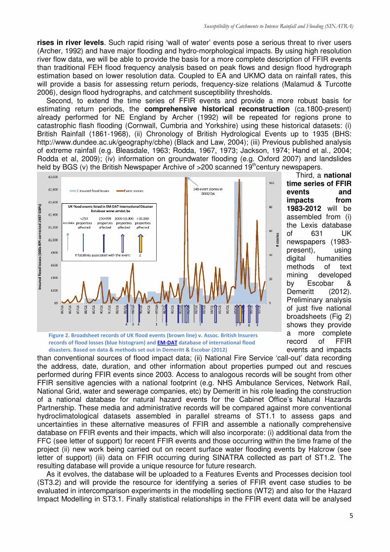
Third, a national time series of FFIR events and impacts from 1983-2012 will be assembled from (i) the Lexis database of 631 UK newspapers (1983-present), using digital humanities methods of text mining developed by Escobar & Demeritt (2012). Preliminary analysis of just five national broadsheets (Fig 2) shows they provide a more complete record of FFIR events and impacts
than conventional sources of flood impact data; (ii) National Fire Service ‘call-out’ data recording the address, date, duration, and other information about properties pumped out and rescues performed during FFIR events since 2003. Access to analogous records will be sought from other FFIR sensitive agencies with a national footprint (e.g. NHS Ambulance Services, Network Rail, National Grid, water and sewerage companies, etc) by Demeritt in his role leading the construction of a national database for natural hazard events for the Cabinet Office’s Natural Hazards Partnership. These media and administrative records will be compared against more conventional hydroclimatological datasets assembled in parallel streams of ST1.1 to assess gaps and uncertainties in these alternative measures of FFIR and assemble a nationally comprehensive database on FFIR events and their impacts, which will also incorporate: (i) additional data from the FFC (see letter of support) for recent FFIR events and those occurring within the time frame of the project (ii) new work being carried out on recent surface water flooding events by Halcrow (see letter of support) (iii) data on FFIR occurring during SINATRA collected as part of ST1.2. The resulting database will provide a unique resource for future research. As it evolves, the database will be uploaded to a Features Events and Processes decision tool (ST3.2) and will provide the resource for identifying a series of FFIR event case studies to be evaluated in intercomparison experiments in the modelling sections (WT2) and also for the Hazard Impact Modelling in ST3.1. Finally statistical relationships in the FFIR event data will be analysed
Figure 2. Broadsheet records of UK flood events (brown line) v. Assoc. British Insurers
records of flood losses (blue histogram) and EM-DAT database of international flood
disasters. Based on data & methods set out in Demeritt & Escobar (2012)

Susceptibility of Catchments to Intense Rainfall and Flooding (SINATRA)
6
to classify events based on rainfall thresholds (spatial, temporal intensities, duration, clustering – with linkages to WT1.3) and flooding processes and hydromorphological impacts. Event classification will enable the time series to be assessed in terms of an index of catchment susceptibility to FFIR, which would be complementary to more traditional methods of flood frequency analysis.
Milestones and deliverables M1.1.1 assemble a comprehensive set of FFIR events and impacts (M12) M1.1.2 classification of events by varying characteristics (M18) D1.1.1 identify and document case study set for WT2 (M12) D 1.1.2 peer reviewed articles for NHESS, J. Flood Risk Management, Global Env. Change (M18)
ST 1.2 Flood Action Team (FloAT) [ST Lead: Russell]
The aim of this subtask is to gather high quality data for FFIR events that occur during the timeframe of the project, and in between such events to focus on the reconstruction of conditions in historical event case studies which will provide essential evidence of system response to FFIR and enable parameters for the high resolution modelling to be quantified.
FFIR is frequently highly localised, affecting small and often un-instrumented catchments. Understanding, predicting and modelling the impacts of FFIR requires critical observations and data on floods and flood-generating processes DURING events as well as post-event surveys and surveys to support historical-event reconstruction by modelling. This is particularly true of measurements of rapid geomorphological change and flood peak hydrodynamics, which are vital for understanding FFIR impacts and validating numerical models, but very rarely taken. This subtask will use fieldwork and novel crowd-sourcing methods to capture past and present FFIR process data providing: key input/validation data for case study catchments for (a) hydraulic modelling of FFIR events (ST2.1/2.2), (b) hydrodynamic modelling of rapid sub-catchment response to intense rainfall (ST.2.1/2.2), (c) identification and characterisation of processes DURING FFIR events (ST1.1).
First, alerted by FFC Flood Guidance Statements and in consultation with regional flood teams at the EA (procedure successfully tested for NERC Storm Risk integration project FloAT; see letter of support FFC), a FLood Action Team (FloAT SINATRA) will mobilise to record the hydrodynamics of FFIR events that occur within the timeframe of the project. Portable equipment will be used to monitor rising limb, peak (or as near to peak as practicable) flow depths, velocities and suspended sediment loads. Although located in the north of the UK, FloAT will ensure that it operates across mainland UK, and will record key FFIR processes and collect ‘immediate’ time-limited post flood data (e.g. flood levels, sediment/debris distribution/volume/calibre). Following the FFIR rapid (hrs-days) post-flood surveys will capture essential evidence of system response to FFIR, such as trashlines and major changes in flood channel morphology using dGPS and robotic Total Station. Remote sensing from airborne LiDAR will be used to quantify post-event inundation area and morphological change by comparing to pre-FFIR data sets. FFIR ‘chasing’ carries the inherent risk of ‘missing’ events, but the FloAT is specifically structured to garner high amounts of post flood data, and the high rates of FFIR ascertained by previous work (ST1.1) suggest there will be several FFIR events to record during the project duration.
Second, public-sourced information on FFIRs, both DURING the project and historical, will be collected through (a) key organisations (e.g. libraries, community groups, FAGs, newspapers), (b) publicising requests for photos, videos and other information to be emailed or uploaded directly to a crowd-sourcing website (built on the OpenSource mapping tools used for recent NE floods e.g. Morpeth and Newcastle, http://ceg-morpethflood.ncl.ac.uk), including use of a novel mobile phone App to upload geotagged and time-stamped images and comments directly and rapidly. These data and responses will be logged and placed in a GIS database and used with the field surveys to reconstruct catchment and urban dynamic flood levels, velocities, debris build-up and release, and evidence of significant geomorphological change (bank collapse, gravel bed change for historical events etc). This will be supplemented by use of the Met Office WoW system (http://wow.metoffice.gov.uk/, see Letter of Support) and its Twitter followers. Use of public-sourcing methods provides the opportunity for close community engagement which can also support gathering of evidence on societal impacts.
Third, forensic examination of FFIR selected from the analysis of historical data in ST1.1 and

Susceptibility of Catchments to Intense Rainfall and Flooding (SINATRA)
7
the above crowd sourcing information will allow a reconstruction of key hydraulic parameters (e.g. maximum flow stage, at-a-point short-term stage variation, sediment/debris dynamics and volumes, channel cross sections). Field surveys (dGPS, TLS from FloAT) will augment these data providing key data for model parameterisation and validation (ST2.1-ST2.3).
Finally, the field quantification of FFIR processes will identify sites of remobilisation of flood-deposited and hillslope sediments, and also identify ‘hotspots’ of erosion for incorporation into new models of rapid catchment response to extreme flash floods caused by intense rainfall events over smaller catchments (ST2.1) . Field data for FFIR events allows critical assessment of existing hydraulic models (ST2.1 – ST2.3) within a range of FFIR catchments. Field data collection from FFIR will be entered into the Features, Events and Processes (FEP) analysis tool described in ST3.2 and the field data will be available (with a short time lag for data quality checking) to the public, with an interactive webpage fronting the data repository.
Milestones and deliverables M1.2.1 Quantification of processes determining incidence and magnitude of FFIR through targeted
cases studies of historical FFIR events, field investigations and modelling (M24 interim;M39 final) M1.2.2 Crowdsourcing & augmentation of historical data (ST2.1) (M24-interim/M39-final) D1.2.1 Analysed field data to inform parameterisation of high resolution hydrodynamic-hydro-
morphological model (ST2.1) (M24-interim/M39-final) D1.2.2 peer reviewed articles for Earth Surface Processes and Landforms, HESS (M39)
ST 1.3 Atmospheric precursors of FFIR [ST Lead: Allan]
This task will quantify and characterise the physical drivers for summer flooding events in the UK through (i) identification of past synoptic situations associated with FFIR impacts (linking strongly with WP1 regarding process representation in NWP models), (ii) analysis of present characteristics and clustering of events including the time and space-scales associated with flood-generating rainfall (spatial extent, duration, intensity, clustering) and (iii) link the large-scale atmospheric conditions and intensity/duration/extent thresholds to catchment types (thereby informing ST3.2 on how to generalise to all catchment types including ungauged cases). Novel diagnostic and statistical techniques will be applied to gridded and in situ observations, atmospheric reanalysis models and climate simulations, such as those from the NERC-funded CONVEX (Fowler PI). We propose to link flooding impacts identified in ST1.1 with the associated large-scale atmospheric conditions, which coarse-scale models, such as those used to generate
reanalysis datasets, are able to represent (e.g. Lavers et al. 2011, 2012). This will provide more reliable assessment of future projections of FFIR (D1.3.3).
Impacts from summer flooding throughout the 20th century (generated in ST1.1) will be linked with large-scale atmospheric properties (D1.3.1) diagnosed using 20CR-V2 (Compo et al. 2011) and pre-release ERACLIM (www.era-clim.eu/) reanalysis 6-hourly fields from which we will compute moisture flux, a key ingredient for FFIR (Lavers et al. 2012) over the last century.
Previous work linking UK winter large-scale fluvial flooding with “Atmospheric Rivers” (narrow ribbons of intense moisture flux) (Lavers et al. 2011, 2012)
will be extended (M1.3.1) to summer FFIR (Fig. 3) with both large-scale and convective processes (Lenderink et al. 2011). The influence of extent, duration, intensity and clustering of systems on the nature and impacts generated from flood events will be analysed using observed hourly gauge datasets from MIDAS and the EA (1960 onwards), high-resolution spatial precipitation fields from radar (2000 onwards) and 1km CHESS data. This will allow identification of rainfall intensity and duration thresholds for
Figure 3. Atmospheric River shown by 900 hPa specific humidity (g/kg)
at 6am on 26 June 2012, a precursor for the Flooding near Newcastle on
28th
June

Susceptibility of Catchments to Intense Rainfall and Flooding (SINATRA)
8
flash-floods in different catchment types, defined by FEH catchment descriptors and other characteristics (D1.3.2). Extreme value statistics (e.g. Fowler and Kilsby, 2003) will be used to determine intensity thresholds, intensity-duration and spatiotemporal characteristics of identified events, extending methods for daily extremes (Jones et al. 2012) to hourly scales. This will advance understanding of future FFIR responses to warming which are highly sensitive to duration/intensity characteristics (Haerter et al. 2010). Since climate models are able to represent large-scale precursor environments (Brooks 2012), our new techniques will provide more reliable, industry and policy-relevant assessments of future FFIR (D1.3.3). Reading and Newcastle provide the expertise in NWP models, satellite datasets and hourly rainfall observations necessary to deliver the outputs required for use in the project and for linkages with both WP1 and WP3. The identification of key atmospheric precursors and rainfall duration/intensity characteristics (determining catchment susceptibility thresholds) will be reported to WT3 (M1.3.2), informing the generalization to all catchment types.
Milestones and Deliverables M1.3.1 Identification of precursors and time/space scales of FFIR events (M12) M1.3.2 Identification of clusters of events and links to catchment types (M24) D1.3.1 Development of a case study set for WT2 intercomparison experiments (M33) D1.3.2 peer reviewed articles for Journal of Climate, Journal of Geophysical Research (M36)
Work Task 2 Improving modelling capability
Worktask 2 aims to improve the physical representation in FFIR models to include currently unrepresented processes known to be crucial during intense rainfall events. It will then upscale these results to parameterise larger scale models for prediction of FFIR risk in ungauged catchments (incorporating uncertainty). It links the local detailed processes of FFIR through to larger scale predictions across a multi model cascade with three tiers: (1) detailed flood process models, (2) catchment scale flood and hydro-morphological models and (3) large scale land surface prediction tools (figure 4). Each modelling approach will be developed, parameterised, validated (with uncertainty) and used in model intercomparison experiments on selected case studies of FFIR. Data for parameterisation and validation will be provided by the database, fieldwork and statistical analysis undertaken in Worktask 1, and through unique flood observation data sets already available to the research team (e.g. Neal et al., 2009, 2011). FFIR case studies will cover a range of data qualities (data-rich to ‘near’-ungauged), and will capture a range of flood processes and catchment types (candidate cases include e.g. Oxford 2007, Morpeth 2008, Carlisle 2005, Tewkesbury 2007, Cockermouth 2009). Higher resolution modelling will be used together with WT1 data in the parameterisation of larger scale models, both of which will be benchmarked against operational methods such as the surface water flood tool of the EA.
ST 2.1 Detailed FFIR processes in flood models [ST Lead: Djordjevic]
Utilising a set of complementary cutting-edge modelling tools this ST will: (i) better capture catchment FFIR hydraulics and local hydro-morphological change at high spatial (<1m) and temporal resolutions; (ii) combine this with urban drainage models to simulate FFIR impacts in urban areas. Based on these findings we also recalibrate and revisit the FFC Surface Water Decision tool for assessment of surface water flood risk. Tools: We will use a multi-model approach using: (i) the Dynamically Adaptive Shock-capturing Hydrodynamic (DASH) model (Liang 2012) (ii) The DASH-Morph model that dynamically couples DASH with bed-load transport for quantifying high resolution hydro-morphological processes and (iii) the Object-oriented shock capturing CityCAT, which can model the rapid response of steep urban catchments to intense rainfall (Glennis at al. 2010); (iv) the 2D UIM (Urban Inundation Model) coupled with the GIS-based multi-layered approach which implements Building Coverage Ratios and Conveyance Reduction Factors (Chen et al., 2012); (v) the SIPSON (Simulation of
Detailed flood process models
•GPU-DASH-Morph
•UIM/SIPSON
•CityCATBos
Catchment flood models
•FUSE
•Lisflood-fp
•CAESAR
Large scale models
•JULES
•Lisflood-fp
Figure 4. The FFIR modelling hierarchy

Susceptibility of Catchments to Intense Rainfall and Flooding (SINATRA)
9
Interaction between Pipe flow and Surface Overland flow in Networks) 1D pipe/channel network model (Djordjević et al., 2005), which is fully coupled with UIM. First, we will increase the speed of the DASH model with the use of GPU parallel computing, which will enable its implementation at very fine resolutions (<1m) across catchments and sub-reaches. We will also further develop and test the DASH-Morph component to simulate interactions between detailed flow patterns and erosion/deposition (e.g. around river structures, bridges, culverts, buildings etc.) and develop relationships to upscale shock capturing effects to WT2.2. Here it is important to evaluate whether or not small scale flow/sediment interactions are important (for example the hydraulic response with and without hydro-morphology feedbacks) during FFIR and to feed this information into the larger scale models of ST2.2. GPU-DASH will then be applied to data-rich case studies such as the Morpeth floods of 2008 and 2012 and used to provide dynamic boundary conditions for the urban flood inundation models. Second, the DASH and SIPSON/UIM models will be combined in order to ensure that all processes at small catchment and urban scales are captured by adequate concepts and in adequate resolution. Two modes will be considered: (1) DASH will be used for simulation of flash floods in the upstream catchment producing boundary conditions for UIM/SIPSON simulations of the surface and pipe network in the urban area and representing both fluvial and pluvial flooding. (2) DASH and SIPSON will be fully coupled, such that interactions between all flows are simulated explicitly throughout an event. For steep urban catchments the additional approach of CityCAT will also be implemented as this captures shock processes in the flood waves. The three approaches will be compared and the catchment parameterisation assessed within an uncertainty framework. First the models will be used to hindcast data rich events (e.g. Morpeth floods of 2008 and 2012 ) and the models will then be run in real time simulation mode driven by high resolution ensemble nowcast/NWP forecasts. The computational speed required for real time applications will be ensured through both the GPU enhancements of DASH and the multi-layered approach within the UIM model. This simulation of high resolution catchment hydraulics and urban drainage, is highly novel and highly relevant to FFIR management.
Finally, using results from above WT PDRA’s, in collaboration with Halcrow, will recalibrate and revisit the FFC Surface Water Flooding Decision tool for assessment of surface water flood risk.
Milestones and Deliverables
M2.1.1 Development of improved GPU-DASH partially and fully coupled with UIM/SIPSON (M15) M2.1.2 Report to WT3 on predictive ability for different catchment types (M21) D2.1.1 peer reviewed articles Water Resources Research, Journal of Hydraulic Research (M30) D2.1.2 Enhanced FFC Surface Water Flooding Decision tool (M33)
Subtask 2.2 Scaling up to the larger catchment [ST Lead: Freer]
This task aims to improve the representation of fast riverine and surface water flooding and hydro-morphological changes in regional scale numerical models of FFIR and to comprehensively evaluate the uncertainties in predictions, boundary conditions, and validation data for these simulations. We assess the hydrology and hydro-morphology of FFIR events numerically with larger catchment and regional scale tools in order to: (i) identify and differentiate catchment vulnerability (to flooding, debris flows, large increases in sediment delivery) at these scales (ii) predict the impact and cost of FFIR on water, sediment, topography, contaminants and infrastructure (iii) deliver a cohesive modelling system concept that can be applied to the UK and readily used by end users (the EA) (iv) quantify uncertainties and associated risks of coupled and integrated models for the above FFIR process representations. Tools: We use a multi-model approach: (i) The unique and newly developed national multi-modelling framework, FUSE, which predicts streamflow at high spatio temporal resolution in >1100 UK catchments (from NERC funded Environmental Virtual Observatory pilot study, Freer) (ii) Lisflood-fp (Bates et al, 2010) a state-of-the-art and computationally-efficient flood inundation model, which is modular, parallelized and has recently been extended to simulate wide area runoff for urban flooding applications (Sampson et al., in press). It is now available as shareware and used across the world in research, commercial, and insurance industry versions and currently being written into the JULES land surface model of the UK Met Office; (iii) e-GLUE, novel limits of acceptability analysis of uncertainty improving assessment of observational uncertainties; (iv)

Susceptibility of Catchments to Intense Rainfall and Flooding (SINATRA)
10
CAESAR-Lisflood, state-of-the-art hydro-morphological change tool incorporating new coupling with LISFLOOD-FP, SCIDDICA (debris flows) and ZOOMQ3D (Groundwater hydrology). First we will analyse Monte Carlo simulations of FUSE across the UK for all catchments for FFIR events which will incorporate different model structure and parameter representations of rainfall-runoff processes evaluated in an uncertainty framework (eGLUE – Liu et al, 2009). This framework improves upon relying on a single model structure representation based on grids (e.g. Bell, et al. 2008) through focus on different hydrologically functional structural representations, which significantly improve their predictive ability of flood responses in different geoclimatic regions and catchment types and sizes across the UK. We base these simulations on data from WT1. The computationally efficient nature of FUSE means that new processes e.g. representation of groundwater can be implemented, along with a comprehensive treatment of predictive uncertainty, including analysis of stage-discharge rating curves and their inherent uncertainties including rating curve extrapolation uncertainties (Krueger et al., 2010). We then implement a linked cascaded representation of uncertain input boundary conditions to generate ensemble simulations of flood inundation extent with Lisflood-fp, producing uncertain flood risk maps for selected data rich test sites for which we already possess high quality models (Carlisle, Neal et al., 2009; Tewkesbury, Neal et al., 2011) and other studies developed in WT2.1. The dominant uncertainties and their propagation through the hydrologic-hydraulic modelling chain will be tested, including the hypothesis that uncertain inflows might mean that lower resolution models, or models built with lower accuracy terrain data or fewer physics, can perform just as well as more expensive implementations, including those in ST2.1, and will establish the trade-off that is possible between spatial resolution, accuracy and precision in order to provide FFIR models tractable for operational practice. The third component of this task models hydro-morphological change through implementation and further development of CAESAR-Lisflood (a recently developed blend of the morphological CAESAR and Lisflood-FP models). CAESAR has already shown the amplification from changes in rainfall to flow to sediment movement for future extreme events in the UK (Coulthard et al., 2012). Here enhancements to deal with rapidly varying flow and LISFLOOD-FP directional biases (de Almeida et al., 2012) will be incorporated along with findings from ST2.1 (high resolution hydraulic/hydromorphic interactions). Debris flows will be added by incorporating the SCIDDICA model (D’Ambrosio et al., 2003; Webb and Wainer, 2008) and groundwater with the ZOOMQ3D model. THE fundamental knowledge gap facing hydro-morphological models is the validation of erosion and deposition. Here we will robustly validate and calibrate CAESAR-Lisflood to sediment yields (at a point and bulk reach values) and measure patterns of erosion and deposition. This step is vital, as hydraulic uncertainties are largely tractable and have a comparatively small impact on final model sediment outcomes – whereas changes in grainsize, and sediment transport models can have a much greater impact upon
erosion and deposition (Coulthard, et al., 2012). For this, (a) palaeo data will be used to retrovalidate predictions by simulating late Holocene upland extreme events that have formed large boulder berm style deposits in the Northern UK (e.g. Macklin and Rumsby, 2007). (b) hydrometric and LiDAR based topographic data from the Cumbria 2009 floods will be used to validate sediment outputs from CAESAR-Lisflood as well as morphological changes (see Figure 5). (c) measurements taken by the FloAT (SWT1.2) will allow validation of CAESAR-Lisflood simulations of flash flood events occurring during this project. Model uncertainty will be determined at all stages of this process and this will provide unprecedented validation against a range of catchment types and sizes. Lastly ensembles of simulations will be used to simulate likely hydro-morphological impacts and vulnerabilities for FFIR events on a range of UK catchments based on data from WP1.
Figure 5. Erosion and deposition derived from before and after
LiDAR images from the 2009 Cockermouth floods

Susceptibility of Catchments to Intense Rainfall and Flooding (SINATRA)
11
Milestones and Deliverables
M2.2.1 Detailed analysis of dominant uncertainties and predictive capability of extreme rainfall flooding events for UK catchments (M24)
M2.2.2 Report to WT3 on modelling approaches, dominant process representation and predictive ability for different catchment types (M30)
D2.2.1 peer reviewed articles HESS, Advances in Water Res., Hydrological Processes (M36) D2.2.2 Updated and validated CAESAR-Lisflood model and national modelling framework, data
and documentation for endusers (e.g. EA), providing tools to identify flood and hydro-morphological risk from FFIR for UK catchments. Online support material and user base support. (M36/42)
Subtask 2.3 Large scale process representation [ST Lead: Mason]
The aim of this task is to provide proof of concept of an integrated land surface modelling approach for predicting FFIR, through model developments that lead to a more realistic representation of surface water, river flow and soil moisture. First, representation of river routing and fast land surface runoff will be developed in the JULES model (Best et al., 2011), along with new strategies of stochastic subgrid parameterisation of hydro-morphological processes such as sediment transport for 100m-1km gridscales. Second, high resolution data assimilation of soil moisture and river discharge will be used to improve ground and channel initial model conditions. The new developments will be validated and then implemented for FFIR events modelled in ST2.1 and ST2.2, and then expanded to assess predictive ability for all UK catchments, including those that are ungauged using information from ST1.1/1.3. As land surface models are usually run as part of weather and climate models, developments in modelled hydrology have the potential to improve water fluxes to the atmosphere and ultimately lead to enhanced meteorological predictions (e.g. Cloke et al, 2011) within a seamless prediction system, a concept coveted by forecasting centres around the world (Pappenberger et al, 2010). Tools: (i) JULES, (the Joint UK Land Environment Simulator), is the UK community land surface model designed to represent the land surface in UK Met Office weather, seasonal and Hadley Centre climate models. (ii) Lisflood-fp (as for ST2.2); (iii) Joint data assimilation of remotely sensed soil moisture and gauged river discharge. JULES currently relies on rather simple surface tile and soil layer representation of the hydrological processes (Richards equation based vertical soil moisture transfers). First we will improve the way JULES deals with key processes such as infiltration overland flow, specifically by making these processes dependent on subgrid pre-rainfall event soil moisture, upslope contributing area and terrain slope (a development of Gedney & Cox, 2003). The 2D hydraulic model LISFLOOD-FP is currently being incorporated into JULES in the NERC DEMON project and here we will also evaluate and test this. We will also develop intelligent subgrid parameterisations developed from the modelling undertaken in ST2.1 and 2.2 in order to represent thresholds of rapid riverine flooding, subgrid surface ponding, sediment transport including debris flow impacts on morphology and blockage, urban drainage and subsurface flow dynamics. Hindcasts will be carried out for test events used in ST2.1/2.2 using the Met Office’s new high resolution ensembles, thus taking account of the meteorological uncertainty with which these tools will have to provide predictions (Cloke & Pappenberger, 2009). It is currently an open question how much assimilation of remotely sensed soil moisture into a hydrologic model can aid runoff prediction in un-gauged basins (Crow & Ryu 2009). A reason for this may be the low spatial resolution of the passive microwave soil moisture data (e.g. ASCAT, SMOS) used in many previous studies (e.g. Brocca et al. 2012). A SMOS pixel (40x40km) is a lot larger than a typical un-gauged small catchment (say 10x10km). A higher resolution (~1km, matching that of a typical hydrological model) would allow soil moisture variations within a small catchment to be detected, and these may have a strong effect on runoff. The advent of the COSMO-SkyMed (CSK) active X-band SAR constellation means that surficial soil moisture (SSM) can now be measured at high spatial (~30m) and temporal (12 hour repeat interval) resolutions using a change detection technique (Balenzano et al. 2011). To cope with the fact that X-band penetrates only a few millimetres into the soil, we propose to retrieve SSM using a segmentation step to identify regions whose backscatter is not dominated by volume scattering from vegetation. SSM would only be measured in large homogeneous regions having low local backscatter

Susceptibility of Catchments to Intense Rainfall and Flooding (SINATRA)
12
variation, such as fields containing pasture. A related aspect to investigate is joint assimilation of both soil moisture and discharge data into the hydrologic model. Model discharge predictions in un-gauged catchments should be improved by taking advantage of nearby gauged catchments. Assimilation of observed discharges into the model of a gauged catchment should improve the estimate of its parameters, and these should generally change only slowly from gauged to neighbouring un-gauged catchments. Sequential assimilation using an EnKF will be used to estimate parameters of the hydrologic model as well as its state variables. We will thus select site and acquire SAR and flow data, extract calibrated SSM observations from CSK SAR and validate against deeper-penetrating ALOS PALSAR L-band data, set up the hydrologic model (dovetailing with the first workflow), set up assimilation system, perform experiments to assess the benefits of assimilating soil moisture using high resolution SAR, and compare with ECMWF’s low resolution (25km) SM-ASS-1 product.
Milestones and Deliverables
M2.3.1 Calibrated/validated SAR soil moisture assimilation (M33) M2.3.2 Interim JULES modules with improved process representation (M24) D2.3.1 peer reviewed articles Journal of Hydrology, Meteorological Applications, IEEE. Trans.
Geoscience Rem. Sens. (M36) D2.3.2 Report to UKMO on predictive capability of JULES for FFIR (M36)
Work Task 3: Impacts and Decision-Support
WT3 address SINATRA objectives 3 and 4 by drawing on results from WT1 and WT2 and developing decision-support tools to integrate SINATRA findings and feed into a subsequent WP3 of the NERC programme.
Subtask 3.1 Improving FFIR impact assessment & impact-based warnings [ST lead: Demeritt]
Building on the improved measurement of FFIR impacts developed in ST1.1, the objective of this subtask is to advance understanding of the underlying drivers of those impacts, in terms of vulnerability and exposure, and to translate that knowledge into tools to enable prediction of future FFIR impacts and support the FFC and Met Office in issuing new ‘impacts-based’ warnings about their occurrence. In particular, this ST will involve close collaboration with project partners at the Met Office and Health & Safety Laboratory (see letters of support), who are working to develop the Hazard Impact Model (HIM) for the Cabinet Office’s Natural Hazard Partnership. The current HIM prototype has fields for the hazard footprint, for exposure and for vulnerability, but there are important questions about how to parameterize the relationships between these determinates of impact, or indeed even about how these fields are conceptualized and whether the secondary effects of FFIR from debris flows and blocked drainage systems should be treated as functions of hazard, vulnerability, or exposure.
ST3.1 will explore these questions by reconstructing 5 case studies of FFIR (as per WT2). Cases are likely to include the 28 June 2012 flooding of central Newcastle and the well documented 2007 groundwater flooding of Oxford (e.g. Macdonald et al. 2012; Chatterton et al 2010), but final selection will be determined by (i) the richness of available impact data collected about them in ST1.1; (ii) the potential to exploit fieldwork and hydrodynamic modelling conducted in WT2; (iii) the need to illuminate a wide range of FFIR processes (ie urban flooding; flash flooding; etc) and impacts (i.e. loss of life, damage to property, disruption to critical infrastructure). For each case additional data on the event and its local impacts will be sought through interviews with members of the Local Resiliency Forum responsible for mobilizing the emergency response and other stakeholders (n=3 per case). These cases will be used to identify generalizable exposure and vulnerability parameters and to assign values relating these functions to impact, paying particular attention to emergency rescues and loss of life, which are not only the best documented impacts, but also the ones of greatest concern to the emergency services and forecasting agencies who serve them. The statistical relationships derived from detailed study of these cases will then be calibrated and tested against the larger FFIR events and impacts database developed in ST1.1 to derive functions for a national scale HIM for FFIR that could be used operationally by FFC and the Met Office to set warning-levels (ie yellow, amber, red) in a more objective, evidence-based way that reflects the specific vulnerabilities and impacts of FFIR.

Susceptibility of Catchments to Intense Rainfall and Flooding (SINATRA)
13
Milestones and Deliverables
M3.1.1 identify suitable case studies for reconstruction (M30) M3.1.2 Integrate vulnerability/exposure/hazard fields of HIM (M39) D 3.1.1 Report on updating HIM to NHP (M42) D 3.1.2 peer reviewed articles Transactions of the Institute of British Geographers, Environment
and Planning A, NHESS (M42)
3.2 Bringing it all together [ST Lead: O’Connell]
Part of the project comes together in SST3.1 above, in the work on “improving FFIR impact assessment and impact-based warnings”. Arguably, though, the FFIR problem involves “tran-science”, because it is very complex and currently beyond science (Weinberg, 1972). The objective of this subtask is therefore to adapt an approach used in another field: safety assessments for radioactive waste management, which also involves complexity, incomplete scientific information, active public interest, and the need to asses risks associated with rare events. A Features, Events and Processes (FEP) analysis model will be designed, developed, populated and tested in an open-source transparent environment, to benefit from direct contributions from the experts in this project and from the wider community. The raw data for the FEP model will be drawn from wide sources because they must cover everything associated with FFIR. This includes knowledge about FFIR, the properties and capability of models, existing data sets and model outcomes, the published literature, and the outcomes from this project.
The FEP model will basically be a database with integrated simple tools for assessing information, importance, hazard, risk, and impact using weighted trees of association. Populating the model (by far the largest task in the PDRA work in ST3.2a) involves gathering, analysing, summarising, linking and giving weights to the numerous physical, mathematical and sociological FEPs that contribute to the understanding of hazard, risk and catchment susceptibility for FFIR. A simple calculation engine will be designed, built and tested in ST3.2b that creates estimates using trees and weights, including estimates for outcomes such as risk. The surprising power of this simple approach comes from the fact that the database holds a “live” comprehensive summary of what is known, what is currently being studied (internationally, as well as in this project), and what is not known. This makes it possible for the calculation engine to generate contextual information alongside its numerical estimates, so for example it can generate a narrative that explains an estimate and says how it could be improved
The deliverable from ST3.2 is the FEP model, in the form of a practical tool to support better decision making, designed for use in knowledge transfer and the scientific exploration of the FFIR problem. It will have calculation tools giving FEP-generated estimates and narratives for importance, hazard and risk in gauged and ungauged catchments. These FEP-generated estimates and narratives will automatically take into account what has been learned in SINATRA because the new knowledge and capabilities generated in SINATRA will be summarised in a subset of the FEPs that describe all the various tasks, concepts, milestones, tools and outcomes for the project. For example, the narrative will include pointers to all the tools from SINATRA (and elsewhere) that could be used to obtain better/alternative estimates for any given level of resource and data availability.
Milestones and Deliverables
M3.2.1 Develop database and programme calculation tools (M15) M3.2.2 Prototype FEP model released, as basis for discussion within the project (M18) D 3.2.1.Live version of SINATRA FEP implemented with peer reviewed article Geosci. Model Dev.
(M42) D 3.2.2 Project Data delivered to data centres (M42)
4. Studentships
Leading edge research projects like SINATRA provide an ideal environment for training the next generation of flood scientists within an interdisciplinary team of leading academic, industrial, and government experts. The 3 student projects have been carefully designed so that they are scientifically novel, but the overall project success is not critically dependent on them. They provide clear added value for both the student research, which would be difficult to achieve outside the

Susceptibility of Catchments to Intense Rainfall and Flooding (SINATRA)
14
bounds of involvement with project SINATRA, and the project itself as they enhance project breadth and depth and visibly strengthen project collaboration.
4.1. Understanding vulnerability and the epidemiology of flood fatalities in the UK [Demeritt & Health
Protection Agency]
Although preventing loss of life is the primary focus for the emergency services during flood events, mortality from flooding in the UK and the risk factors associated with it are poorly understood (Jonkman & Kelman 2005). It is often asserted that the old, the disabled and the poor are the most vulnerable to flooding (e.g. Parker et al 2009), but evidence from France and the US suggests that the demographic profile of flash flood victims (typically young, male and wealthy enough to be driving in cars or participating in outdoor recreation) is very different to those killed by slow onset fluvial and coastal floods, who tend to be elderly, handicapped, or otherwise immobile (Ruin et al. 2008). Building on the database of FFIR impacts and events developed in ST1.1, this studentship project will also draw on ONS death registrations and the National Water Safety Forum’s WAter Incident Database (WAID) of drowning to document the scale of fatalities from flooding in the UK and the ways in which mortality risk may vary between groups and by location or type of flood event. It will deliver improved understanding of vulnerability and so enable forecasting agencies to improve the targeting of warnings to reach those most vulnerable to particular events.
4.2 Extending the flood record: Assessing the uncertainty and viability of Palaeo flood data [Coulthard, Freer]
Using historical and palaeo-data to enhance the length and magnitude of gauged flood records can be an important approach but may have significant limitations. For example; (i) the Carbon and Luminescence dating of flood units contains significant error bounds (14C +-50-100 years, TL/OSL +-100-200 years) making it impossible to precisely date events; (ii) The context of sedimentary records – where they lie in a catchment - is highly important and (iii) fluvial records are palimpsest – they can be overwritten by subsequent events. To address this, early approaches used histograms of multiple dated flood deposits and later PDF’s based on the error bars of the dates (Macklin et al, 2006) . However, important methodological shortcomings in such approaches were identified by Chiverrell et al. (2011). This raises key questions: is palaeo data reliable enough to help extend flood records? How does uncertainty propagate through this process? Here, for the first time, we aim to comprehensively determine the uncertainty associated with palaeo-flood records and to assess the robustness of this method for augmenting flood recurrence data.
4.3 Discrete Element Modelling of Floating Debris [Liang, Large, Parkin]
The rapidly-varying flows related to flash floods can pick up and transport a cargo of debris, threatening lives and causing severe damage to structures. Yet, no research has been reported to quantify the interactive processes between the flood wave, floating objects and impacted structures. This student project is designed to fill the current knowledge gap and develop new analytical and modelling tools for understanding the hydrodynamic flow processes associated with floating debris and their implications for flood risk in terms of creating local blockages and changing flood routes. The student will join the Flood Action Team (FloAT) working on ST1.2 to carry out field work and collect data for understanding the behaviour of floating debris driven by rapidly-varying flood waves. A range of approaches for quantifying the amount of woody debris entering rivers under investigation streams will be reviewed and tested using the empirical data collected. With regard to modelling, Stockstill et al. (2009) have shown the potential of using a decoupled discrete element model (DDEM) for simulating floating objects (e.g. ice and debris) in river flows. In the context of flash floods, a fully coupled hydrodynamic and DDEM model is required to represent the active interaction between background flow and floating objects in a much more violent hydrodynamic context. Therefore, the Newcastle DASH model will be further developed to enable full dynamic coupling with a DDEM achieved by including the counter-forces of floating objects acting on the fluid in the governing equations as extra source terms. After being calibrated and validated against field data, the new DASH-DDEM model will be used to carry out parameter studies to quantify debris flow processes and their impact on flood hydrodynamics and hence flood risk. This student project will deliver new field datasets and tools for quantifying the impacts of floating debris during flash flood events.

Susceptibility of Catchments to Intense Rainfall and Flooding (SINATRA)
15
5. Expected outcomes and long-term legacies from SINATRA
As a result of the above research SINATRA will deliver a step-change in both scientific understanding of flooding from intense rainfall and in the operational capabilities for managing the risks it poses to life and property. The long term legacy of our work will be a continuing reduction in the risks and losses caused by surface water and flash floods. SINATRA addresses all aspects of NERC’s Research Programme on Flooding from Intense Rainfall. The scientific innovation and impacts delivered by its integrated programme of data analysis, physical process modelling, and societal impact assessment go significantly beyond those envisaged in the AO for WP2 to include:
1. benchmark data on historic FFIR events and their impacts that will provide the evidence-base needed to identify ‘at risk’ gauged and ungauged catchments and target warnings and other policy interventions so as to reach the groups and communities most vulnerable to FFIR;
2. new high resolution data on runoff, hydraulics, sediment transport and other FFIR processes to underpin future breakthroughs in understanding and predicting their event dynamics;
3. the first ever climatological analysis of large scale atmospheric precursors of FFIR needed to extend forecast lead times and provide earlier warnings to the public;
4. innovative hydraulic models (DASH and SIPSON/UIM) capable of representing, for the first time, the full detailed process dynamics, physics, and length scales typical of FFIR events, thus substantially improving the accuracy of predictions;
5. unique regional scale hydrological tools (FUSE) to translate detailed process understanding into robust predictions at scales needed for strategic planning and decision making;
6. the world’s first catchment scale model for debris flow and erosion based on true shallow water hydraulics (CAESAR-lisflood) which radically improves our predictive ability across all catchment types for understanding hydro-morphological susceptibility to FFIR;
7. a major upgrade to the JULES land surface scheme that will enhance the UKMO unified model, and thereby improve flood and drought forecasting as well as seasonal and climate prediction;
8. joint work with UKMO and HSLE for the Cabinet Office’s Natural Hazard Partnership to develop the Hazard Impact Model to improve FFIR impact assessment & impact-based warnings.
Our ability to generate this added value stems from the skills, tools, techniques and data sets that are uniquely available to the SINATRA team and without which, we believe, the programme and AO requirements cannot be addressed. The multidisciplinary team of world-leading experts from academia, industry, and government assembled to deliver the SINATRA programme is therefore uniquely placed to deliver the innovative programme of high impact science needed by the UK to meet the challenge of reducing and managing intense rainfall flood risk.
6. References De Almeida, G et al (2012). Improving the stability of a simple
formulation of the shallow water equations for 2D flood modelling. Water Resources Research, 48, paper W05528.
Archer, D. R. (1992) Land of Singing Waters - Rivers and Great Floods of Northumbria, Spredden Press
Balenzano et al. (2011). Dense temporal series of C- and L-band SAR data for soil moisture retrieval over agricultural crops. IEEE JSTARS, 4(2), 439-450
Bates, P.D et al (2010). A simple inertial formulation of the shallow water equations for efficient two dimensional flood inundation modelling. Journal of Hydrology, 387, 33-45.
Bell VA et al. (2007) Development of a high resolution grid-based river flow model for use with regional climate model output. Hydrology and Earth System Sciences, 11(1): 532-549
Best, M., et al. (2011) The Joint UK Land Environment Simulator (JULES), Model description – Part 1: Energy and water fluxes. Geosci. Model Dev. Discuss., 4, 595–640.
Beven KJ and Cloke HL (2012), Comment on “Hyperresolution global land surface modeling: Meeting a grand challenge for monitoring Earth's terrestrial water” by Eric F. Wood et al., Water Resour. Res., 48, W01801, doi: 10.1029/2011WR010982
Black AR, Law FM (2004) Development and utilization of a national web-based chronology of hydrological events. Hydrolog. Sci. J. 49, 237-246;
Bleasdale A (1963) The distribution of exceptionally heavy falls of rain in the United Kingdom, 1863-1960, J. Inst. Water Engrs, 17
Brocca et al. (2012). Assimilation of surface- and root-zone ASCAT soil moisture products into rainfall-runooff modelling. IEEE. Trans. GeoScience Rem. Sens., 50(7), 2542-2555
Cao Z, et al. (2011) Hydrodynamic modelling in support of flash flood warning. Pro. ICE, Water Management 163 (WM7): 327-40
Chatterton J et al (2010) The Costs of the Summer 2007 Floods in England Project: EA-Defra FCERM R&D Programme project SC070039/R1
Chen A.Set al., (2012). Multi-layered coarse grid modelling in 2D urban flood simulations, Journal of Hydrology, (in press).
Chiverrell RC, et al. (2011) Cumulative probability functions and their role in evaluating the chronology of geomorphological events during the Holocene. J. Quaternary Sci.26 76-85
Clark, M.P., et al. (2008) Framework for Understanding Structural Errors (FUSE): A modular framework to diagnose differences between hydrological models. Water Res. Research
Cloke HL, & Pappenberger F (2009) Ensemble Flood Forecasting: A Review. J. Hydrology 375 613-626
Cloke, H.L., et al. (2011) Representing uncertainty in land surface hydrology: fully coupled simulations with the ECMWF land surface scheme, in Proceedings of the ECMWF/WMO/WCRP workshop on "Representing Model Uncertainty and Error in Numerical Weather and Climate Prediction Models”

Susceptibility of Catchments to Intense Rainfall and Flooding (SINATRA)
16
Coulthard TJ et al (2012) Using the UKCP09 probabilistic scenarios to model the amplified impact of climate change on river basin sediment yield. Hyd. Earth Syst.Sci. Dis. 9: 8799–8840.
Crow WT, Ryu D (2009). A new data assimilation approach for improving runoff prediction using remotely-sensed soil moisture retrievals. Hydrol. Earth. Syst. Sci., 13, 1-16
D’Ambrosio D et al (2003), First simulations of the Sarno debris flows through Cellular Automata modelling. Geomorphology 54, 91–117
Demeritt D. (2012) The perception and use of public weather services by emergency and resiliency professionals in the UK. Report for the Met Office Public Weather Service Customer Group. 2 March. 38 pp
Djordjević S., et al. (2005). SIPSON – Simulation of Interaction between Pipe flow and Surface Overland flow in Networks, Water Science and Technology, 52(5), 275-283
Escobar M, Demeritt, D (2012) Flooding and the framing of risk in British broadsheets, 1985-2010 Public Understanding of Science DOI: 10.1177/0963662512457613
Fowler HJ, Kilsby (2003) A regional frequency analysis of United Kingdom extreme rainfall from 1961 to 2000. Int.J Climatology 23: 1313-34.
Gedney N, Cox PM (2003) The sensitivity of global climate model simulations to the representation of soil moisture heterogeneity, J. Hydromet. 4: 1265–1275.
Glennis, V, et al., (2010), CITY CAT – Urban flood modelling and analysis software, Report to EA
Haerter, J. O., et al., (2010). Heavy rain intensity distributions on varying time scales and at different temperatures. Journal of Geophysical Research, 115. D17102
Hand W et al. (2004) A study of 20th century extreme rainfall
events in the UK. Met.Applications 11: 15--‐31 Hapuarachchi HAP et al. (2011). A review of advances in flash
flood forecasting. Hydro. Pro. 25:2771-84 Hurford AP et al. (2012), The effectiveness of extreme rainfall
alerts in predicting surface water flooding in England and Wales. Int. J. Climatol., 32: 1768–1774.
IPCC (2012) Managing the Risks of Extreme Events and Disasters to Advance Climate Change Adaptation. Cambridge UP
Jackson MC (1974) Largest two-hour falls of rain in the British Isles, Weather, 29
Johnson C, Priest S (2008) Flood Risk Management in England: A Changing Landscape of Risk Responsibility?” Water Resour. Dev. 24: 513-25.
Jones, MR, et al., (2012). An assessment of changes in seasonal and annual extreme rainfall in the UK between 1961 and 2009. International Journal of Climatology.
Jonkman, S. N. and Kelman, I. (2005), An Analysis of the Causes and Circumstances of Flood Disaster Deaths. Disasters, 29: 75–97
Krueger, T., et al. (2010) Ensemble evaluation of hydrological model hypotheses. Water Resour. Res 46(W07516): 1-17
Lavers DA et al (2011) Winter floods in Britain are connected to atmospheric rivers, Geophys. Res. Lett. , 38, L23803,
Lavers, DA., et al., (2011) Winter floods in Britain are connected to atmospheric rivers, Geophys. Res. Lett. , 38, L23803,
Lee H et al., (2006) Predicting runoff in ungauged UK catchments, Proc. Inst. Civ. Eng. Water Management., 159, 129-38
Lenderink, G. et al., (2011). Scaling and trends of hourly precipitation extremes in two different climate zones—Hong Kong and the Netherlands. Hydrology and Earth System Sciences, 15(9), 3033.
Liang Q (2012) A simplified adaptive Cartesian grid system for solving the 2D shallow water equations. Int. J. Numerical Methods in Fluids, 69: 442–458
Liu, Y.L., Freer, J., Beven, K., Matgen, P., (2009) Towards a limits of acceptability approach to the calibration of hydrological models: Extending observation error. J. Hydrology, 367: 93-103.
Macdonald DMJ, et al (2012) Groundwater flooding within an urbanised flood plain. J.Flood Risk Management 5: 68–80
Macklin, M.G., et al (2006) Past hydrological events reflected in the Holocene fluvial history of Europe Catena 66 145-54.
Macklin, M & Rumsby, B. (2007), Changing climate and extreme floods in the British uplands. Trans. Inst. Brit. Geog. 168–186.
Malamud BD & Turcotte DL (2006) The applicability of power-law frequency statistics to floods: J. Hydr., 322(1–4):168–180
Merz B et al. (2010) Assessment of economic flood damage. Nat. Hazards Earth Syst. Sci. 10: 1697-1724
Neal JC et al (2009) Distributed whole city water level measurements from the Carlisle 2005 urban flood event and comparison with hydraulic model simulations. J. Hydrology, 368(1), 42-55.
Neal, J., et al., (2011). Evaluating a new LISFLOOD‐FP formulation with data from the summer 2007 floods in Tewkesbury, UK. J Flood Risk Management, 4: 88-95.
Pappenberger, F., Cloke, H. L., et al. (2010), Global runoff routing with the hydrological component of the ECMWF NWP system. Int. J. Climatol., 30: 2155–2174. doi: 10.1002/joc.2028Cloke
Pappenberger F et al. (2012) Deriving Global flood hazard maps of fluvial floods Hydrology an d Earth System Science, doi:10.5194/hessd-9-6615-2012
Parker D et al. (2009) Understanding and enhancing the public’s behavioural response to flood warning information. Meteorol. Appl. 16, 103–114
Pitt Review (2008) Learning Lessons from the 2007 Floods. PWSCG (2010) Public Weather Warning Service Review-
Consultation. Report by the UKMO Public Weather Service Customer Group.
Rodda, JC (1967) A country wide study of intense rainfall for the United Kingdom, J. Hydrol., 5
Rodda, JC (1973) The study of magnitude, frequency and distribution of intense rainfall in the United Kingdom, British Rainfall 1966, 3
Rodda, H.J.E., et al (2009) A digital archive of extreme rainfall in the British Isles from 1866 to 1968 based on British Rainfall, Weather, 64(3) 71-75.
Ruin, I, et al. (2008) Human exposure to flash floods - Relation between flood parameters and human vulnerability during a storm of September 2002 in Southern France. J. Hydrology, 361, 199-213.
Sampson, CC et al. (in press). An automated routing methodology to enable direct rainfall in high resolution shallow water models. Hydrological Processes.
Stockstill RL, et al. (2009) Modeling floating objects at river structures. ASCE-Journal of Hydraulic Engineering, 135(5) 403 – 414
Thielen et al (2009) The European Flood Alert System: Concept and Development. Hydrology & Earth Syst. Sci. 13, 125-40
Wass, P., D et al., (2008) Flash Flood! A lucky escape for 10,000 bikers, BHS 10th National Hydrology symposium, Exeter.
Webb, B.& Wainer, G.A. (2008), Implementing the SCIDDICA landslide model in Cell-DEVS 15.
Weinberg AM (1972) Science and trans-science Minerva 10:209-22 Wood, EF, et al., (2011). Hyperresolution global land surface
modeling: Meeting a grand challenge for monitoring Earth's terrestrial water. Water Resour. Res. 47(5), W05301.