Embed Size (px)
Citation preview
SUSAN ISLAND NATURE RESERVE
DRAFT PLAN OF MANAGEMENT NSW National Parks and Wildlife Service Part of the Department of Environment and Climate Change (NSW) April 2009

Acknowledgments This draft plan of management was prepared by staff of the North Coast Region of NPWS, part of the Department of Environment and Climate Change (DECC). Valuable information and comments were provided by DECC specialists, the Regional Advisory Committee, current and former members of Susan and Elizabeth Islands Recreation Trust, and other members of the public. Inquiries about Susan Island Nature Reserve should be directed to NPWS Clarence South Area, 49 Victoria Street (PO BOX 361), GRAFTON NSW 2460 or by telephone on 02 6641 1500. Disclaimer: This publication is for discussion and comment only. Publication indicates the proposals are under consideration and are open for public discussion. Provisions in the final management plan might not be the same as those in this draft management plan. © Department of Environment and Climate Change (NSW) 2009: Use permitted with appropriate acknowledgment. ISBN 978 1 74232 214 8 DECC 2009/254

INVITATION TO COMMENT
The National Parks and Wildlife Act 1974 (NPW Act) requires that a plan of management be prepared that outlines how an area will be managed by the NSW National Parks and Wildlife Service (NPWS). The procedures for the exhibition and adoption on plans of management are specified in the NPW Act and involve the following stages: • The draft plan is placed on public exhibition for at least 90 days and any person may
comment on it; • The plan and submissions received on the plan are referred to the Regional Advisory
Committee for consideration; • The plan, submissions and any advice from the Regional Advisory Committee are
referred to the National Parks and Wildlife Advisory Council for consideration; • The plan, submissions and the recommendations of the Advisory Council are referred
to the Minister administering the NPW Act, and a copy referred to the Regional Advisory Committee;
• After considering the submissions, the recommendations of the Advisory Council and any advice from the Regional Advisory Committee, the Minister may adopt the plan or may refer the plan back to the NPWS and Council for further consideration.
Members of the public, whether as individuals or as members of community interest groups, are invited to comment on this plan of management. Submissions should be in writing, and as detailed and specific as possible. However any comments, no matter how brief, are welcome. Comments should be forwarded to:
The Planner, Susan Island NR NPWS
PO BOX 361 GRAFTON NSW 2460
The closing date for comments on the plan is Monday 31st August 2009. All submissions received by NPWS are a matter of public record and are available for public inspection upon request to NPWS. Your comments on this draft plan may contain information that is defined as "personal information" under the Privacy and Personal Information Protection Act 1998. The submission of personal information with your comments is voluntary.
SUSAN ISLAND NATURE RESERVE AND LOCALITY

1
1. SUSAN ISLAND NATURE RESERVE: LOCATION, GAZETTAL AND REGIONAL SETTING
Susan Island Nature Reserve is located in north-eastern NSW on the Clarence River, adjacent to the city of Grafton (29°41.4'S, 152°55.8'E). It was gazetted on 14 May 1982 to protect the rainforest remnant at the north-western (upstream) end of Susan Island.
The current area of the nature reserve is approximately 18 hectares, of which 16.5 hectares are rainforest. The boundary of the nature reserve is the river bank (mean high water mark), and a line across the island which is defined as being 50 metres north-west of the centreline of the (now underground) transmission line (see map). Another transmission line traverses the reserve’s north-western tip. The remainder of the island (currently approximately 70 hectares) is a Crown Reserve which is managed by the Susan and Elizabeth Islands Recreation Trust (referred to in this plan as the Trust). This section of island was largely cleared and now comprises abandoned pasturelands and woodland, with some isolated rainforest trees that have been the focus for regeneration efforts. Until 1982, the Trust managed the whole of Susan Island.
The Clarence River is a major feature within the region, and has played a significant part in shaping the surrounding landscape over time. Susan Island and nearby Carrs Island are the most upstream of the major islands located within the Clarence River’s large estuary. Susan Island takes its name from the schooner “Susan”, which in 1838 was one of the first ships to travel up the Clarence River and the first to transport cedar logs from the Clarence Valley to Sydney (Mackey 2001).
Susan Island Nature Reserve protects an important remnant of floodplain rainforest, a rare survivor of the once extensive areas of lowland subtropical rainforest that covered the banks of the coastal rivers prior to European settlement. As such, it has important biogeographical links to other floodplain rainforest found, for example, in Stotts Island Nature Reserve in the Tweed River, Wingham Brush Nature Reserve in the Manning Valley, and on Bellingen Island in the Bellinger River. Coramba Nature Reserve on the Orara River is the only other significantly intact area of floodplain rainforest protected in the Clarence catchment.
The reserve is a prominent and notable landscape feature, and is of significance to both indigenous and non-indigenous people. The island has iconic value to the local Grafton community due to its history of recreational use. In addition, Aboriginal women have a close and ongoing association with the island and its rainforest. A group of Aboriginal women, Nyami Julgaa, is recognised and acknowledged as the cultural custodians of Susan Island.
As well as having highly significant botanical and cultural values, the reserve is also an important roosting and breeding area for flying-foxes. During summer months in some years, the nightly flight of flying-foxes from the island at dusk is a spectacular event.
Susan Island Nature Reserve is located within the boundaries of the Clarence Valley local government area, the Grafton-Ngerrie Local Aboriginal Land Council and the North Coast Livestock Health and Pest Authority. The reserve is in close proximity to the central business districts of Grafton and South Grafton. The landscape surrounding the reserve supports a range of land uses, including cattle grazing, urban and rural residential development, and industrial uses. The river adjacent to the reserve is a major recreation resource for the local community and is also used for fishing and the extraction of sand and gravel.
2
2. MANAGEMENT CONTEXT 2.1 Legislative and Policy Framework
The management of nature reserves in NSW is in the context of a legislative and policy framework, primarily the National Parks and Wildlife Act 1974 (NPW Act), the NPW Regulation, the Threatened Species Conservation Act 1995 (TSC Act) and the policies of the National Parks and Wildlife Service (NPWS). These policies are based on the legislative background and internationally accepted principles of park management, and relate to nature conservation, Aboriginal and historic heritage conservation, recreation, commercial use, research and communication.
Other legislation, international agreements and charters may also apply to management of the area. In particular, the Environmental Planning and Assessment Act 1979 (EPA Act) may require the assessment and mitigation of environmental impacts of works proposed in this plan. The Commonwealth Environment Protection and Biodiversity Conservation Act 1999 (EPBC Act) also applies in relation to actions that may impact on matters of national environmental significance, such as migratory species and threatened species listed under that Act.
A plan of management is a statutory document under the NPW Act. Once the Minister has adopted a plan, no operations may be undertaken within the reserve, except in accordance with the plan. The plan will also apply to any future additions to Susan Island Nature Reserve. Where management strategies or works are proposed for the reserve or any additions that are not consistent with the plan, an amendment to the plan will be required.
2.2 Management Purposes and Principles
Nature reserves are reserved under the NPW Act to protect and conserve areas containing outstanding, unique or representative ecosystems, species, communities or natural phenomena.
Under the Act (section 30J), nature reserves are managed to: • conserve biodiversity, maintain ecosystem functions, and protect geological and
geomorphological features and natural phenomena; • conserve places, objects, features and landscapes of cultural value; • promote public appreciation, enjoyment and understanding of the reserve’s natural and
cultural values; and • provide for appropriate research and monitoring.
Nature reserves differ from national parks in that the provision for sustainable visitor use and enjoyment is not a management principle.
2.3 Management Directions
In addition to the management principles given above, the following specific directions apply to the management of Susan Island Nature Reserve: § Continued close cooperation with Nyami Julgaa and with the Trust over management of
the reserve. § Ongoing enhancement of the long-term viability of the island’s rainforest through weed
control and active rainforest regeneration works while simultaneously managing it as an important flying-fox roost.
§ Interpretation of the reserve’s cultural and biological values primarily through guided tours and displays off reserve.

3
3. VALUES OF THE RESERVE
3.1 Landform, Hydrology and Soils
At 22 660 square kilometres, the Clarence River has the largest catchment of the east-flowing rivers in New South Wales. At a point upstream of Grafton and still more than 70 kilometres from the coast, the river enters its estuary, which is characterised by an extensive floodplain and islands. Susan Island and nearby Carrs Island and Rabbit Island (also known as Peanut Island) are the most upstream of the major islands. The tidal influence in this reach of the Clarence River estuary is limited; however water quality can still become brackish, particularly during periods of drought.
The island is a mobile vegetated shoal in the river, formed as a result of riverine processes. It consists of alluvial materials, such as sandy and loamy sediments and occasional gravels, sourced from the upstream catchment. It is generally flat with the exception of several shallow gullies and minor rises which reach an elevation of about 8 metres above normal river levels. Its long and narrow tapering landform has lengthened considerably in the past 200 years through continued deposition of sediment at its eastern (downstream) tip (Peck & Cooney 2004). At the same time, the upstream end of the island (within the nature reserve) is subject to ongoing erosion, particularly along the unstable vertical cliffs of its southern bank. The oldest parts of the island and its highest point occur within the nature reserve.
The southern channel of the Clarence River immediately adjoining the southern edge of Susan Island is subject to extraction of gravel and sand under a licence from the Department of Lands, and this maintains deep water in the channel. It is not known whether the impacts of this operation are affecting the stability of the southern bank of the island.
In contrast to sediments in other rivers on the North Coast, alluvial soils in the Clarence Valley primarily derive from sandstone and associated parent material rather than from volcanic origins. Hence, soils in the reserve are of generally low fertility. They are of moderate to high surface erosion hazard, with potential for mass movement particularly along the island’s steep southern bank.
The Clarence River is considered a stressed river system and its water quality is variable, often carrying elevated volumes of sediment (HRC 1999). While increased sediments in the river contribute to the growth of the island through the deposition of silt, the river’s waters also transport weed propagules from upstream sources. During major flood events, the island is completely inundated. Floods can cause damage to vegetation in the reserve, scour exposed soils and increase the rate of bank erosion. Bank erosion is also increased by wave activity from wind and power boats.
3.2 Native Plants
Except for approximately 0.5 hectare of clearing under the transmission line that traverses the reserve’s north-western tip, the nature reserve is forested, in clear contrast to the abandoned pasturelands and woodland which dominate the rest of the island. The rainforest of the island is listed as part of an endangered ecological community under the TSC Act: Lowland Rainforest on Floodplain in the NSW North Coast Bioregion. The stand of rainforest on Susan Island is the largest remaining example of this type of rainforest in the Clarence Valley. It is isolated, very small in size and at risk of potentially catastrophic damage from storms, floods and other events.
The Susan Island rainforest is an example of Floyd’s subtropical rainforest suballiance 3 (Floyd 1990), typically characterised by pepperberry tree (Cryptocarya obovata), giant

4
stinging tree (Dendrocnide excelsa), figs (Ficus spp.) and hoop pine (Araucaria cunninghamii). Due to the lower rainfall and poorer soil conditions present at Susan Island than is typical for this vegetation type, the most common canopy species in the reserve are associated with the dry rainforest subform of this suballiance, namely: shiny-leaved stinging tree (Dendrocnide photinophylla), tulipwood (Harpullia pendula), lacebark (Brachychiton discolor) and forest red gum (Eucalyptus tereticornis) (Floyd 1990). Four species of fig are present, including several large Moreton Bay figs (Ficus macrophylla) which are conspicuous elements of the rainforest canopy. The reserve features the largest remaining stand of tulipwood in NSW, and large specimens of formerly prized commercial timber species such as black bean (Castanospermum australe), red bean (Dysoxylum mollissimum subsp. molle) and white cedar (Melia azederach). Red cedar (Toona ciliata) was reportedly cut from the island between 1838 and 1842 and there is no regeneration of this species (Floyd 1990). It is thought that other prized rainforest timber species (e.g. rosewood (Dysoxylum fraserianum), blue quandong (Elaeocarpus grandis) and silky oak (Grevillea robusta)) may have been present at the time of settlement but were also harvested to local extinction on the island (M. Clarke, pers. comm. 2008).
The native flora occurring in the reserve consists of 57 tree species, 8 shrubs, 19 herbs and 21 vines (as at November 2006). Following poaching of ferns and orchids in the 19th and early 20th centuries (Law 1973), there is now only one epiphytic orchid recorded from the reserve. It is presumed that the absence of cabbage-tree palms (Livistona australis) until 2006 may also be related to earlier poaching efforts (D. Fahey, pers. comm. 2008). The reserve contains a small population of white bean (Ailanthus triphysa), comprising a single large individual and several suckers, at this species’ southern limit of distribution.
3.3 Native Animals
An early record of the natural history of Susan Island described a diverse animal life, including koalas, quolls, possums, gliders, pademelons, echidnas and flying-foxes (Wilcox 1870). In the early 1920s, wildlife in the rainforest was a major attraction for visitors and still included a wealth of species, although ‘even then the older members of the community said it could not be compared with what it was when they first knew it’ (Law 1973, p.1). The reserve’s rainforest and riparian vegetation still support a diverse bird life, as well as 11 reptile and 15 mammal species (Clancy & Clancy 2001); some of these are listed as threatened under the TSC Act (see Table 1).
The reserve is an important refuge for species that are dependent or semi-dependent on rainforest, such as the noisy pitta (Pitta versicolor), which is near the southern limit of its distribution in the reserve. A number of other birds that generally use more open forest, such as the white-bellied sea eagle (Haliaeetus leucogaster) and some shorebirds, also inhabit the edges of the reserve.
Flying-foxes are the most conspicuous animals found in Susan Island Nature Reserve, which is the most significant traditional major roost site between the Bellinger and Richmond rivers (Lunney & Moon 1997). The reserve contains major roost sites for three species of flying-fox, including the grey-headed flying-fox (P. poliocephalus), little red flying-fox (P. scapulatus) and black flying-fox (Pteropus alecto). The little red and grey-headed flying-foxes have used the same area of rainforest on Susan Island as a major maternity roost site since at least 1870 and more than likely well before European settlement (Lunney & Moon 1997). Black flying-foxes were first recorded on the island in 1996 (Clancy & Clancy 2001), and numbers of this species appear to be increasing every year. Black flying-foxes now also use the reserve as a maternity camp in increasing numbers.

5
Depending on the season, there may be many tens of thousands of flying-foxes on the island, with numbers in summer sometimes exceeding 100 000. There is some history of attempts to control flying-fox numbers on the island up until at least the 1950s (Anon. 2000, 2001), including an attempted ‘total destruction’ in 1877 (Lunney & Moon 1997). In recent decades however, this camp is noteworthy for lacking the controversy and problems that surround many other contemporary urban flying-fox camps.
The number of flying-foxes using the camp has increased manyfold over the years, more than likely due to the decreasing availability of suitable alternative locations in the region as a result of the habitat clearing that has occurred (Law 1973; Lunney & Moon 1997). Over time, the increasing use of the reserve by flying-foxes has damaged the rainforest through roosting bats breaking and defoliating upper and middle branches in the canopy. Repeated use of a roost site in consecutive years tends to suppress regrowth of canopy foliage, making this a major problem (Hall 2002). Considerable gaps in the forest canopy have been opened through this process and also due to storm events, creating favourable conditions for weed species to establish and flourish.
It has been speculated since the late 1950s that the canopy damage on Susan Island caused by flying-foxes threatens the integrity and viability of this rainforest, and that there is a conflict between protecting the rainforest and protecting its use as a flying-fox camp (Law 1973; Lunney & Moon 1997).
Assisted and ongoing bush regeneration in the areas affected by roosting flying-foxes is necessary to allow both the rainforest and the flying-fox camp to survive into the future. Expanding the area of rainforest available, to provide options for the flying-foxes to move their roosting area around could lessen damage to vegetation (Hall 2002).
Table 1 Threatened fauna species occurring in Susan Island Nature Reserve
Common name Scientific Name Status* Osprey Pandion cristatus Vulnerable Large bent-wing bat Miniopterus schreibersii Vulnerable Eastern free-tail bat Mormopterus norflokensis Vulnerable Large-footed myotis Myotis adversus Vulnerable Grey-headed flying-fox Pteropus poliocephalus Vulnerable # Yellow-bellied sheathtail bat Saccolaimus flaviventris Vulnerable Greater broad-nosed bat Scoteanax rueppellii Vulnerable * Status under TSC Act # Denotes species also listed as nationally threatened under the EPBC Act.
3.4 Aboriginal Cultural Heritage
Evidence of Aboriginal settlement on the banks of the Clarence River 12 kilometres upstream of Susan Island has been dated at 6500 years before present (McBryde 1966). It is therefore likely that Susan Island and its rainforest has been used by Aboriginal people for many thousands of years.
Aboriginal communities have an association and connection to the land. The land, the water, and the plants and animals found within the whole landscape are the centre of Aboriginal spirituality and contribute to Aboriginal identity. Aboriginal communities associate natural resources with the use and enjoyment of valued foods and medicines, caring for the land, passing on cultural knowledge and strengthening social bonds. Aboriginal heritage and nature are inseparable from each other and need to be managed in an integrated manner across the landscape.
6
The traditional use of the forest as a source of food and traditional medicines has continued since European arrival. Almost half of the native plants on the island are known as useful plants to the Aboriginal women of the area. Aboriginal foods are obtained from seeds, fruit, leaves, stems and underground parts. Bark, vine, stems, roots and leaves are used for making string and rope for bags, nets, fishing line and decorations. Vine stems are woven into baskets or fish traps, while many plants on the island also have traditional medicinal uses. Traditional and contemporary use of these resources forms part of the ongoing use of the nature reserve by Aboriginal people.
Forests are also traditionally places of religious and spiritual value to Aboriginal people, both in terms of tracts of country and specific sites (Hall & Lomax 1993). Susan Island is a registered site of significance to the Aboriginal women of the Clarence Valley. A group of women, Nyami Julgaa, are recognised and acknowledged as the cultural custodians of Susan Island.
3.5 Historic Heritage
The Clarence Valley was settled by Europeans in the late 1830s, initially by cedar getters and quickly followed by graziers. By 1842, the easily accessible red cedar on the Clarence floodplain had been cut and lands around Grafton were being cleared. The small rainforest remnant in Susan Island Nature Reserve, although now devoid of red cedar, is all that remains of the once extensive cedar brushes of the Clarence Valley which first attracted Europeans to the area (Floyd 1973).
Susan Island was first dedicated as a reserve for public recreation in February 1870 and for the preservation of birds in 1893. A community-based trust was appointed in March 1870 to manage the island; and a trust has managed all or part of the island ever since.
Susan Island has a well-documented history as a popular recreation place for the communities of Grafton and South Grafton until the 1940s. At its peak in the 1920s, weekly visitation numbered in the hundreds. Most of the recreation use was concentrated near the south-eastern end of the island, outside what is now the nature reserve. This use was facilitated by the Trust, through the construction of facilities such as picnic areas, bathing sheds, toilets, water tanks, a rotunda and a dance pavilion. A rifle range and a scout camp were also located on the island. The opportunity to explore the rainforest was one of the island’s attractions. It featured ‘cool, pleasant walking trails and a fig tree over 100 foot (30 metres) high’ (Lunney & Moon 1997, p.257).
Before 1932, access to the island was provided by the ferry linking Grafton and South Grafton. Visitation to the island declined markedly after the Grafton Bridge was opened in 1932, which led to the termination of the regular ferry service across the Clarence River. Access after this time relied on boats (which were available for hire from near the Prince St wharf). The tragic drowning of 13 cub scouts in 1943 and the loss of all facilities on the island in a wild fire in 1944 further reduced interest in visiting the island. With the decline in recreational use, the Trust’s revenue was much reduced, being limited to grazing permits from the 1940s until 1997 (B. Fahey, pers. comm. 2007). In the 1940s, Susan Island was considered as a potential site for a National Fitness Camp but interest in this proposal waned in the 1950s. A cross-island fence along the edge of the rainforest was constructed by the Trust in 1974 to protect the remaining rainforest vegetation, although cattle still continued to stray into the forest on occasions.
In 1975 a proposal to protect the island’s rainforest as a nature reserve was made by the Clarence Valley Field Naturalists Club, gaining the support of the Trust in 1979. Attempts by the Trust to expand the area of the nature reserve by 16 hectares in the early 1990s were stymied by objections from the Department of Mineral Resources (now part of the Department

7
of Primary Industries). The Trust continues to manage the south-eastern three-quarters of the island.
4. THREATS TO RESERVE VALUES
4.1 Introduced Species
4.1.1 Weeds
Weeds pose the major problem in the nature reserve due to their interference with natural regeneration processes. Gap dynamics is a major driver of rainforest growth and regeneration. Disturbances, such as the death of old trees or damage by flying-foxes and storms, lead to openings in the canopy which allow sunlight to penetrate to the forest floor. This encourages growth by suppressed seedlings and vines to fill the available niches in the gap. To maintain the structural and floristic integrity of a rainforest community, it is important that these gaps regenerate with native species that will grow to restore the upper canopy. Natural regeneration, however, has often been hampered by a proliferation of weed species which out-compete native species or stifle their growth.
Lantana (Lantana camara) and other weeds had reportedly established on the island by 1922 (Law 1973). Within the reserve, the number of weed species has been increasing over time; currently 56 introduced plants are recorded. Lantana, privets (Ligustrum spp.), white mulberry (Morus alba), Cocos palm (Syagrus romanzoffiana), Chinese elm (Celtis sinensis), ochna (Ochna serrulata), green cestrum (Cestrum parqui), orange jessamine (Murraya paniculata) and camphor laurel (Cinnamomum camphora) are common in Grafton, and are probably dispersed to the island by birds and/ or flying-foxes. The establishment of escaped exotic garden plants has been preliminarily determined to be a key threatening process under the TSC Act.
Flood waters also transport weed propagules to the reserve from upstream infestations. It is thought that most of the major vine weeds present in the nature reserve were introduced by floods, including balloon vine (Cardiospermum grandiflorum) (only recorded since the 2001), cat’s claw creeper (Macfadyena unguis-cati) (absent for many years before the 1996 flood), Dutchman’s pipe (Aristolochia elegans), Madeira vine (Anredera cordifolia) and morning glory (Ipomoea spp.). Dense infestations of common trad (Tradescantia fluminensis), which prevent seed germination and smother ground plants, probably also originally arrived in earlier floods. Invasion and establishment of exotic vines and scramblers is listed as a key threatening process under the TSC Act. These have significant adverse effects on biodiversity, smothering native vegetation, choking the canopy and preventing recruitment.
Outside the reserve, native revegetation of the island has been stymied by lack of resources and the dense growth and invasive nature of exotic grasses. Scattered infestations of exotic grasses such as kikuyu (Pennisetum clandestinum) and Rhodes grass (Chloris gayana) are also present in the nature reserve where the canopy is broken. Invasion of native plant communities by exotic perennial grasses is also listed as a key threatening process.
The major management operation on the island is rainforest regeneration, undertaken by staff and contractors, and in a cooperative effort with the Trust. As part of the regeneration efforts, weeds are controlled and trees planted.
4.1.2 Pest Animals
A number of pest animals have been recorded in the reserve. Sightings of European red fox (Vulpes vulpes) on the island extend back to the 1930s, after which time most ground-dwelling fauna disappeared (Law 1973). Observations of this species indicate that
8
populations tend to remain relatively stable, with several foxes persisting each year. As individuals are controlled, it is believed that new individuals swim across the river and establish territories on the island. Thus any control program needs to be ongoing and coordinated with other agencies and landholders in the district.
At least two records of feral cats (Felis catus) have been made on Susan Island. Little was known of the population size and dynamics and there have been no sightings for many years. Introduced rodent species known to occur on the island include the black rat (Rattus rattus) and house mouse (Mus musculus). The black rat is common in the rainforest and the house mouse is generally found outside the reserve (Clancy & Clancy 2001).
While the fox and black rat are present on the island, ground-dwelling mammal and reptile fauna, as well as ground-foraging or low nesting bird species, will continue to be threatened or will be excluded from the island (Clancy & Clancy 2001).
4.2 Floods
As an island on the floodplain, floods have always had a major role in shaping both the island and its vegetation. Floods deposit sediment and plant propagules. Floods are also a form of disturbance that can create canopy gaps within the rainforest and, with the increasing prevalence of weed species in riverbank vegetation upstream of the island, introduce weed propagules to the reserve from upstream infestations.
Susan Island is significantly inundated in small flood events (as low as a 5 year event) and, in the 100 year events, flood depths over the island exceed 4 metres with an average estimated velocity of about 1 metre/second (WBM Oceanics Australia 2004). In the river channels and along the banks of the island, velocities may be up to 3 metres/second. The shearing force of these flood waters can uproot trees and scour riverbanks, particularly in the vicinity of shallow-rooted trees such as the introduced camphor laurel.
Flood dynamics are strongly influenced by the levee banks on both sides of the Clarence River. These have increased flood levels in the vicinity of Susan Island by as much as 0.8 metres (as measured at the gauge near the wharf at the end of Prince Street). The majority of this increase was as a result of levee works constructed prior to 1974 which effectively narrowed the channel for flood water flow, resulting in higher and faster flood waters in the vicinity of the island.
During the March 2001 flood, which reached the level of 7.7 metres at the Prince Street gauge and was the fourth highest flood recorded in 170 years, the island was fully submerged for a long period of time, leading to significant levels of dieback and vegetation damage.
4.3 Fire
Fire is a feature of the landscape of the Clarence Valley and is one of the continuing physical factors influencing the Australian environment. Inappropriate fire regimes can cause loss of particular plant and animal species and communities; frequent fires have been identified as a key threatening process affecting the biological diversity of NSW.
The fire history of the reserve is poorly documented. Fires are thought to be relatively infrequent due to its location and the persistence of rainforest vegetation. A survey plan of the island prepared in 1926 indicates an extensive area outside the current boundaries of the reserve of ‘old burnt brush now thick lantana with some green timber’. Plants that grow in subtropical rainforest have few adaptations to surviving fire and generally do not support fire, and a single wildfire in the rainforest may be potentially devastating. The continued presence of rainforest in the reserve therefore indicates that fires may not have occurred in this part of the island for centuries.

9
In contrast, the long grass which dominates the vegetation of the island outside the reserve poses a higher bushfire risk due to its greater flammability and potential to carry fires. In previous decades, grazing was the primary tool used to manage the grass on the island; the removal of all livestock in the early 1940s during a tick eradication program is blamed for the devastating fire in 1944 which destroyed all the old visitor facilities in the south-east of the island, including the dance pavilion (Law 1973). There appears to have been an absence of fire on the island during the 1980s and 1990s but one fire occurred in 2000 and another two fires occurred in late 2006. It is presumed that the fires that have occurred on the island have been deliberately lit.
4.4 Fragmentation and Isolation
The current rainforest on Susan Island is a small isolated remnant, and approximately one third of the size that it was at the time of European settlement. While the extent of this rainforest area was always limited it was supported ecologically by the presence of similar rainforest on the surrounding banks of the river (Lang 1847, printed in Peck & Cooney 2004). This is now cleared and the rainforest on Susan Island is therefore highly isolated. A number of local extinctions of plant and animal species, both documented and extrapolated, have occurred on the island.
Edge effects from the abrupt transition to pasture on the eastern boundary of the reserve also affect the rainforest’s ecology. Measurable microclimatic changes in the physical environment can extend 15-60 metres from the edge into a rainforest remnant, which can have profound effects on some species of plants and animals. Edges are also more prone to increased windshear forces, which may lead to increased frequency of tree fall and other disturbances (Hunter 1999).
Plant species in small remnants are frequently represented in very low numbers, often few or single trees. Such species are acutely prone to local extinction due to flood, fire or storm impacts. When remnants are as isolated as on Susan Island, inbreeding can lead to reduced seedling recruitment. In the case of species that cannot self-pollinate, such as the white bean, single individuals are considered functionally extinct (Williams & Adam 1999) and hence enhancement by planting seedlings sourced elsewhere may be appropriate.
4.5 Climate Change
Anthropogenic climate change has been listed as a key threatening process under the TSC Act due to its anticipated impacts on biodiversity, through changes in the geographical extent of habitats and ecosystems, and subsequent changes in population size and distribution of species.
Sea-level rise is one of the projected outcomes of climate change, with a sea-level rise of between 18 and 59 centimetres expected by 2100 in the absence of icesheet melt (IPCC 2007). This will result in: increased intensity and frequency of storm surges; increased shore erosion; impacts on coastal ecosystems; and impacts on human settlements and infrastructure (CSIRO 2004). These impacts will be exacerbated by the expected increased frequency of extreme storm events.
While the potential impact of climate change for the reserve is difficult to predict with any accuracy (since it depends on the compounding effects of other pressures), the most immediate impacts are likely to be felt in terms of increased disturbance to the rainforest from storms and floods, and increased duration of periods of drought stress and exposure to saline water, reducing the extent and viability of the rainforest.
10
5. USE OF THE RESERVE 5.1 Access and Visitor Use
Access to the island is by boat. The nearest boat ramps are located at South Grafton and Grafton, and the Trust currently maintains a wharf on the island (see map). In the 1980s, free boating access was organised by the Trust in conjunction with the Grafton Water Brigade. In the 1990s, NPWS Discovery Tours were regularly conducted in the reserve on public holidays, also relying on the Grafton Water Brigade. These ceased following a boat accident in 2000.
The Trust maintains a picnic area near to the wharf. A mown path formerly linked the picnic area on the Trust’s land to the nature reserve. This is currently overgrown. Within the nature reserve itself, there is a 300 metre loop natural surface walking track through the rainforest, which used to have trackside signage highlighting the features of the rainforest. NPWS maintains a landing place near the eastern powerlines and a mown path to the start of the walking track, primarily for management access.
Visitor numbers to the reserve are low and primarily focused on nature-based activities such as bushwalking and bird watching. Volunteers occasionally undertake bush regeneration activities on the Trust’s section of Susan Island, and often visit the reserve while on the island.
5.2 Other Uses
Two Country Energy 66 kilovolt electricity transmission lines traverse Susan Island. One of these traverses the north-western end of the reserve in a north-south direction. This line is above ground, located within a cleared corridor and supported by a single pole in the nature reserve. The line was constructed prior to gazettal of the nature reserve and no formal easement for the line was granted at that time.
The other line is located outside the nature reserve (50 metres east of the boundary). This was originally installed above-ground in 1932 (Lunney & Moon 1997), also without a formal easement. When the line required replacing in the 1990s, the Trust negotiated the replacement of the line underground where it crossed the island. A formal easement for this line is within lands managed by the Trust and, while rainforest regeneration can now be promoted within the broader easement, Country Energy requires that a narrow corridor (approximately 2 metres wide) along the cable alignment be kept relatively clear for maintenance access purposes. The fence that was constructed in the 1970s along the edge of the cleared corridor under the powerlines has now fallen into disrepair since the removal of livestock from the island in 1996 and has become heavily overgrown with kikuyu, vines and other weeds.
Commercial fishing operators occasionally use parts of the shores of Susan Island for small scale beach hauling. Rarely if ever does this occur on the steep, narrow banks of the nature reserve. The Grafton Rowing Club has installed and uses markers for its boat races at several points alongside the island, one of which occurs in waters adjacent to the nature reserve.

11
6. MANAGEMENT ISSUES AND RESPONSES
Current Situation Desired Outcomes MANAGEMENT RESPONSE Priority
6.1 Soil Conservation
The alluvial soils in the reserve have a moderate to high potential hazard for erosion. As the reserve is situated on the upstream end of the island, it is exposed to continued erosive shear from river flow. This is a natural process, and sediment continues to be deposited on the downstream end of the island (outside the reserve).
Construction of the Grafton levees in the 1960s has resulted in higher and faster flood waters on the island. During the floods in 2001 the island was fully submerged for a long period and there was extensive flood damage to soils and also vegetation.
Erosion, particularly during floods, has created unstable vertical cliffs of alluvium along the southern bank of the reserve. It is not known if this is exacerbated by dredging in the river next to the reserve. Accessing the reserve from the southern bank impacts on recolonising vegetation, aggravating the situation.
Soil disturbance also exists within the reserve as a result of tree fall and vegetation damage during floods, particularly in the vicinity of shallow-rooted trees such as the introduced camphor laurels.
• Erosion within the
reserve resulting from human activity is minimised.
• Natural fluvial
processes are maintained.
6.1.1 Undertake all works, such as walking track maintenance and weed control, in a manner that minimises soil erosion and water pollution. 6.1.2 Minimise disturbance to the southern bank by discouraging access along this bank through signage. Contractors and staff will access the reserve from the northern bank. 6.1.3 Work with the Department of Lands to assess potential causes of erosion along the southern bank of the reserve and investigate ways to improve bank stability.
High
Medium
Medium
6.2 Native Biodiversity
The rainforest on Susan Island is a rare and important rainforest remnant, listed as an endangered ecological community. It is small in size and isolated from other similar remnants. Several plant species are believed to have become locally extinct on the island due to past
• There is an
increased understanding and knowledge of the biodiversity values of the reserve.
6.2.1 Undertake or encourage appropriate research that increases knowledge of native plants and animals within the reserve, particularly their historic and current populations, distribution and ecological needs, with particular emphasis on significant and isolated species.
Medium

12
Current Situation Desired Outcomes MANAGEMENT RESPONSE Priority activities. White bean occurs in the reserve at its southern limit. While the single large individual appears to have produced several suckers, it is unlikely to produce viable seed given its isolation from other mature individuals.
Seven threatened animal species have been recorded in or near the reserve. The reserve is a significant maternity roosting site for the threatened grey-headed flying-fox and other flying-fox species. Flying-fox populations are monitored by NPWS staff and local wildlife carers. Avian populations are monitored by local ornithologists.
Threats to the short-term viability of the rainforest include established weed populations particularly of exotic vines, the continued reintroduction of weed propagules by birds, bats and flood waters, and canopy damage from flying-foxes. The latter is exacerbated by frequent use of the reserve as a camp due to limited alternative camp sites in the region.
Significant weed control and rainforest restoration projects have been undertaken in the nature reserve since 1989. Considerable improvement in the overall health of the rainforest community has been achieved. The nature of the threats, however, requires ongoing weed management to prevent further decline.
As the island is gradually moving downstream through fluvial processes, the long-term viability of the rainforest will require revegetation outside the reserve on Susan Island. The majority of the Trust-managed lands are currently managed to encourage the regeneration of native forest, with only limited areas at the south-eastern end of the island to be maintained as open space (NCEP 2006).
• The reserve
continues to be both an important rainforest remnant and flying-fox camp.
• The long-term
viability of the island’s rainforest is enhanced by rainforest revegetation on the floodplain outside the nature reserve.
6.2.2 Establish a “Friends of Susan Island” community group to support bush regeneration programs in the reserve, and across the island with the agreement of the Trust, and the monitoring of bird and flying-fox populations. 6.2.3 Promote and monitor regeneration of native vegetation in disturbed or degraded areas. As required, assist natural regeneration through weed control and strategic planting of both rainforest and open forest species. Non-local provenance seedlings, preferably sourced from the next nearest remnant in the Clarence Valley, may be used in the case of plants with suspected non-viable populations or to reintroduce locally extinct species. 6.2.4 Work with the Clarence Valley Council, the Susan and Elizabeth Islands Recreation Trust, Landcare groups and other landholders to expand the area of rainforest on the Clarence floodplain through revegetation of cleared areas outside the reserve.
High
High
High
6.3 Cultural Heritage
13
Current Situation Desired Outcomes MANAGEMENT RESPONSE Priority
Susan Island is a recorded Aboriginal site. While the significance of the site to the Aboriginal women of the Clarence Valley is primarily associated with the rainforest, the whole island has cultural value. The continued understanding and use of the native plants which occur in the reserve is also culturally important. Continued weed control and rainforest restoration works aid in the cultural protection of the area.
It is important that the local Aboriginal community is involved in the protection of cultural values in the reserve. A group of Aboriginal women, Nyami Julgaa, are recognised and acknowledged as the cultural custodians of Susan Island. There is ongoing consultation with this group to ensure that cultural values of the reserve are protected. The members of Nyami Julgaa have indicated their desire for the nature reserve to be renamed to better reflect its importance to the Aboriginal community. They have also requested that no facilities be put in the reserve.
Historic values of Susan Island are largely located outside the reserve, on lands managed by the Trust. While there are no known historical sites within the reserve, the rainforest itself has heritage value as an important remnant of the early landscape of Grafton and is listed on the Register of the National Estate.
• Cultural features
are identified, conserved and managed in accordance with their significance.
• Aboriginal heritage
values are recognised and protected in partnership with the local Aboriginal community.
• Aboriginal
community continues to have access to plants for traditional purposes.
• The local
community are aware of the cultural values of the island.
6.3.1 Work with Nyami Julgaa, other members of the local Aboriginal community, the Grafton-Ngerrie Local Aboriginal Land Council and knowledge holders to identify and manage Aboriginal cultural heritage sites, places and values. 6.3.2 Assist in the nomination of Susan Island as an Aboriginal Place to formally recognise its importance. 6.3.3 Work with Nyami Julgaa to identify a suitable, culturally appropriate name for the nature reserve, and seek to have the reserve renamed. 6.3.4 Undertake or encourage appropriate cultural heritage surveys and other appropriate research to identify and record Aboriginal or historic cultural sites and values within the reserve. 6.3.5 Liaise with Nyami Julgaa and the Trust on the interpretation of the cultural values of Susan Island.
High
High
Medium
Medium
Medium
6.4 Introduced Species
The NPWS North Coast Regional Pest Management Strategy (DECC 2008) identifies the priorities for the management of pest plant and animal species in the national parks and reserves across the North Coast Region. For Susan Island Nature Reserve, the strategy recognises the established and widespread infestations
• The impact of
introduced species on native species is controlled and reduced.
• The population and
6.4.1 Monitor and control noxious and environmental weeds in accordance with the Regional Pest Management Strategy. Priority will be given to the control of exotic vines, camphor laurels and smothering ground covers. Intensify weed efforts after floods. 6.4.2 Develop, in conjunction with the Trust, a
High
Medium

14
Current Situation Desired Outcomes MANAGEMENT RESPONSE Priority of exotic vines, woody weeds (such as mulberries and privets), and herbaceous weeds (such as ground asparagus and common trad). Invasion by vines is recognised as a key threatening process and the control of vines is a priority. Privet, lantana, green cestrum and camphor laurel are listed as noxious weeds in the Clarence Valley local government area and these are also priorities for control.
A comprehensive, planned approach to weed management is currently being implemented and is based around 6 monthly bush regeneration and weed control programs undertaken by contractors. Restoration works are monitored and the program adapted accordingly.
Efforts to control weeds on the island date from the 1920s (Law 1973; Lunney & Moon 1997). Given the reserve’s position in the catchment and the continual re-introduction of weed propagules from outside sources, reactive weed control must continue to ensure the viability of the rainforest.
While black rats and European red foxes are known to be present in the reserve, little pest animal management has taken place (being limited to fox den fumigation when located). The reserve’s location on an island and the absence of most suitable prey species has meant that pest control has not been considered a regional priority in the absence of control measures in surrounding areas.
distribution of introduced species do not expand beyond their current extent.
• Control measures
have minimal negative impacts on native species.
• There is increased
community support and cooperation for control measures.
vegetation management plan for the island to prioritise weed control and rainforest regeneration efforts. 6.4.3 Monitor the implementation of bush regeneration programs and weed control methods undertaken in the reserve to determine the effectiveness of treatments and to inform ongoing control priorities. 6.4.4 Continue to liaise with the Susan and Elizabeth Islands Recreation Trust, Clarence Valley Council, the North Coast Livestock Health and Pest Authority, and other stakeholders in implementing coordinated weed and pest animal control programs. 6.4.5 Provide information to the community regarding the impacts of weeds and pest animal species. 6.4.6 In conjunction with the Trust, investigate the potential for an island-wide fox and rodent baiting program and implement if feasible. 6.4.7 In liaison with the Northern Rivers Catchment Management Authority, promote efforts in the upper Clarence catchment to control priority weed species, particularly exotic vines.
High
Medium
High
Medium
Medium
6.5 Fire Management
A separate fire management strategy has been prepared for Susan Island Nature Reserve. In accordance with the Clarence Valley Zone Bush Fire
• Fire is excluded
from the reserve. • The potential for
6.5.1 Implement the fire management strategy for the nature reserve to exclude fire from the reserve. Suppress all unplanned fires as quickly as possible and install signs to indicate that the lighting of fires in the nature reserve is
High
15
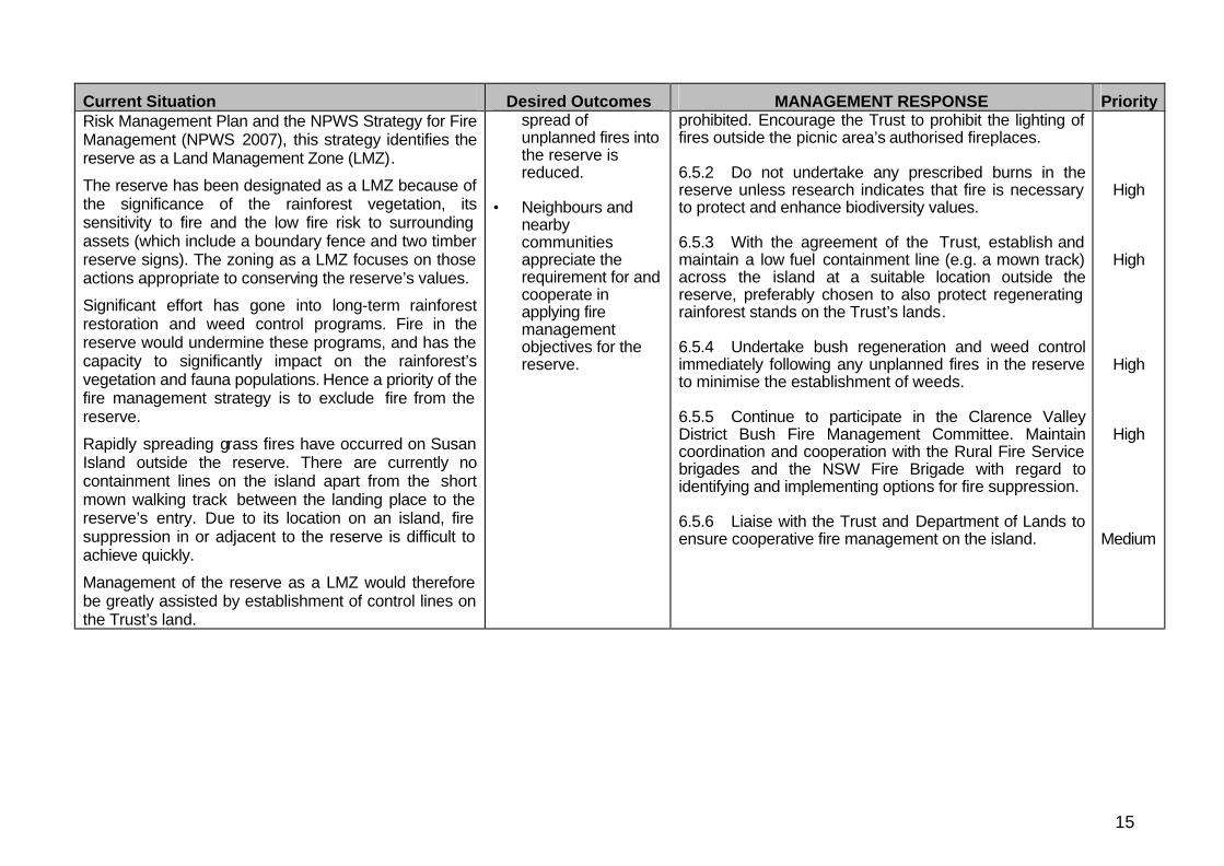
Current Situation Desired Outcomes MANAGEMENT RESPONSE Priority Risk Management Plan and the NPWS Strategy for Fire Management (NPWS 2007), this strategy identifies the reserve as a Land Management Zone (LMZ).
The reserve has been designated as a LMZ because of the significance of the rainforest vegetation, its sensitivity to fire and the low fire risk to surrounding assets (which include a boundary fence and two timber reserve signs). The zoning as a LMZ focuses on those actions appropriate to conserving the reserve’s values.
Significant effort has gone into long-term rainforest restoration and weed control programs. Fire in the reserve would undermine these programs, and has the capacity to significantly impact on the rainforest’s vegetation and fauna populations. Hence a priority of the fire management strategy is to exclude fire from the reserve.
Rapidly spreading grass fires have occurred on Susan Island outside the reserve. There are currently no containment lines on the island apart from the short mown walking track between the landing place to the reserve’s entry. Due to its location on an island, fire suppression in or adjacent to the reserve is difficult to achieve quickly.
Management of the reserve as a LMZ would therefore be greatly assisted by establishment of control lines on the Trust’s land.
spread of unplanned fires into the reserve is reduced.
• Neighbours and
nearby communities appreciate the requirement for and cooperate in applying fire management objectives for the reserve.
prohibited. Encourage the Trust to prohibit the lighting of fires outside the picnic area’s authorised fireplaces. 6.5.2 Do not undertake any prescribed burns in the reserve unless research indicates that fire is necessary to protect and enhance biodiversity values. 6.5.3 With the agreement of the Trust, establish and maintain a low fuel containment line (e.g. a mown track) across the island at a suitable location outside the reserve, preferably chosen to also protect regenerating rainforest stands on the Trust’s lands. 6.5.4 Undertake bush regeneration and weed control immediately following any unplanned fires in the reserve to minimise the establishment of weeds. 6.5.5 Continue to participate in the Clarence Valley District Bush Fire Management Committee. Maintain coordination and cooperation with the Rural Fire Service brigades and the NSW Fire Brigade with regard to identifying and implementing options for fire suppression. 6.5.6 Liaise with the Trust and Department of Lands to ensure cooperative fire management on the island.
High
High
High
High
Medium
16
Current Situation Desired Outcomes MANAGEMENT RESPONSE Priority
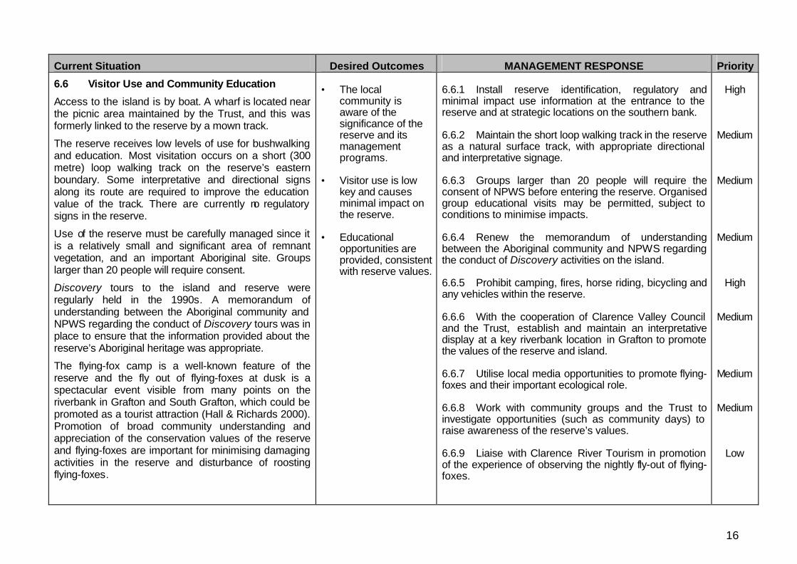
6.6 Visitor Use and Community Education
Access to the island is by boat. A wharf is located near the picnic area maintained by the Trust, and this was formerly linked to the reserve by a mown track.
The reserve receives low levels of use for bushwalking and education. Most visitation occurs on a short (300 metre) loop walking track on the reserve’s eastern boundary. Some interpretative and directional signs along its route are required to improve the education value of the track. There are currently no regulatory signs in the reserve.
Use of the reserve must be carefully managed since it is a relatively small and significant area of remnant vegetation, and an important Aboriginal site. Groups larger than 20 people will require consent.
Discovery tours to the island and reserve were regularly held in the 1990s. A memorandum of understanding between the Aboriginal community and NPWS regarding the conduct of Discovery tours was in place to ensure that the information provided about the reserve’s Aboriginal heritage was appropriate.
The flying-fox camp is a well-known feature of the reserve and the fly out of flying-foxes at dusk is a spectacular event visible from many points on the riverbank in Grafton and South Grafton, which could be promoted as a tourist attraction (Hall & Richards 2000). Promotion of broad community understanding and appreciation of the conservation values of the reserve and flying-foxes are important for minimising damaging activities in the reserve and disturbance of roosting flying-foxes.
• The local
community is aware of the significance of the reserve and its management programs.
• Visitor use is low
key and causes minimal impact on the reserve.
• Educational
opportunities are provided, consistent with reserve values.
6.6.1 Install reserve identification, regulatory and minimal impact use information at the entrance to the reserve and at strategic locations on the southern bank. 6.6.2 Maintain the short loop walking track in the reserve as a natural surface track, with appropriate directional and interpretative signage. 6.6.3 Groups larger than 20 people will require the consent of NPWS before entering the reserve. Organised group educational visits may be permitted, subject to conditions to minimise impacts. 6.6.4 Renew the memorandum of understanding between the Aboriginal community and NPWS regarding the conduct of Discovery activities on the island. 6.6.5 Prohibit camping, fires, horse riding, bicycling and any vehicles within the reserve. 6.6.6 With the cooperation of Clarence Valley Council and the Trust, establish and maintain an interpretative display at a key riverbank location in Grafton to promote the values of the reserve and island. 6.6.7 Utilise local media opportunities to promote flying-foxes and their important ecological role. 6.6.8 Work with community groups and the Trust to investigate opportunities (such as community days) to raise awareness of the reserve’s values. 6.6.9 Liaise with Clarence River Tourism in promotion of the experience of observing the nightly fly-out of flying-foxes.
High
Medium
Medium
Medium
High
Medium
Medium
Medium
Low
17
Current Situation Desired Outcomes MANAGEMENT RESPONSE Priority
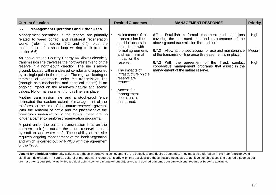
6.7 Management Operations and Other Uses
Management operations in the reserve are primarily related to weed control and rainforest regeneration works (refer to section 6.2 and 6.4), plus the maintenance of a short loop walking track (refer to section 6.6).
An above-ground Country Energy 66 kilovolt electricity transmission line traverses the north-western end of the reserve in a north-south direction. The line is above ground, located within a cleared corridor and supported by a single pole in the reserve. The regular clearing or trimming of vegetation under the transmission line (through both mechanical and chemical means) is an ongoing impact on the reserve’s natural and scenic values. No formal easement for this line is in place.
Another transmission line and a stock-proof fence delineated the eastern extent of management of the rainforest at the time of the nature reserve’s gazettal. With the removal of cattle and the placement of the powerlines underground in the 1990s, these are no longer a barrier to rainforest regeneration programs.
A point under the eastern transmission lines on the northern bank (i.e. outside the nature reserve) is used by staff to land water craft. The usability of this site requires ongoing management of the bank vegetation, and which is carried out by NPWS with the agreement of the Trust.
• Maintenance of the
transmission line corridor occurs in accordance with formal agreements and has minimal impact on the reserve.
• The impacts of
infrastructure on the reserve are reduced.
• Access for
management operations is maintained.
6.7.1 Establish a formal easement and conditions covering the continued use and maintenance of the above-ground transmission line and pole. 6.7.2 Allow authorised access for use and maintenance of the transmission line once this easement is in place. 6.7.3 With the agreement of the Trust, conduct cooperative management programs that assist in the management of the nature reserve.
High
Medium
High
Legend for priorities: High priority activities are those imperative to achievement of the objectives and desired outcomes. They must be undertaken in the near future to avoid significant deterioration in natural, cultural or management resources; Medium priority activities are those that are necessary to achieve the objectives and desired outcomes but are not urgent.; Low priority activities are desirable to achieve management objectives and desired outcomes but can wait until resources become available.

18
REFERENCES
Anon. 2001. Backward Glances: Extracts from the Daily Examiner 50 years ago today. The Daily Examiner, 17 December 2001
Anon. 2000. Backward Glances: Extracts from the Daily Examiner 50 years ago today. The Daily Examiner, 15 December 2000, p.12
Clancy, G.P. & Clancy, V.A. 2001. The Fauna of Susan Island, Grafton. Unpublished report prepared for the Susan and Elizabeth Islands Recreation Trust and the NSW National Parks and Wildlife Service.
CSIRO (2004). The Facts: Global Sea Level Rise. Accessed on 22 June 2006 from http://www.marine.csiro.au/LeafletsFolder/45slevel/45.html
DECC 2008. NPWS North Coast Region Pest Management Strategy 2008-11. Department of Environment and Climate Change NSW, Sydney
Floyd, A.G. 1973. Deterioration of Rainforest on Susan Island. Unpublished letter to Grafton City Council, dated 4 September 1973.
Floyd, A.G. 1990. Australian Rainforests in New South Wales: Volume 2. Surrey Beatty & Sons, Chipping Norton, NSW.
Hall, L. & Richards, G. 2000. Flying foxes: Fruit and blossom bats of Australia. University of New South Wales Press, Kensington.
Hall, L.S. 2002. Management of flying fox camps: What have we learnt in the last twenty five years? Pp. 215-224 in P. Eby & D. Lunney (eds) Managing the Grey-headed Flying Fox as a Threatened Species in NSW. Royal Zoological Society of NSW, Mosman.
Hall, R. & Lomax, K. 1993. Archaeological report, Casino Management Area, Northern Region, State Forests of NSW: Casino Management Area EIS Supporting Document No. 1. State Forests of NSW, Pennant Hills, NSW.
HRC 1999. Independent Inquiry into the Clarence River System. Final report November 1999. Healthy Rivers Commission of New South Wales.
Hunter, R.J. 1999. Fragmentation – the Consequences. Pp.19-28 in S. Horton (ed) Rainforest Remnants: A decade of growth. NSW National Parks and Wildlife Service, Hurstville.
IPCC (2007) Climate Change 2007: The Physical Science Basis. Contribution of Working Group I to the Fourth Assessment Report of the Intergovernmental Panel on Climate Change [Solomon, S., D. Qin, M. Manning, Z. Chen, M. Marquis, K.B. Averyt, M.Tignor and H.L. Miller (eds.)]. Cambridge University Press, Cambridge, United Kingdom and New York, NY, USA.
Lang, J.D. 1847. Drawing of Susan Island published in his book, Cooksland. Photograph of drawing on p.19 of Peck & Cooney 2004.
Law, D.R. 1973. Susan Island. Unpublished report submitted to NPWS, Sydney, written in early 1973, and subsequently printed in The Daily Examiner on 26 October 1973.

19
Lunney, D. & Moon, C. 1997. “Flying foxes and their camps in the remnant rainforests of north-east New South Wales”, pp. 247-277 in J. Dargavel (ed.) Australia’s Ever-Changing Forests III: Proceedings of the third national conference on Australian forest history. Centre for Resource and Environmental Studies, Australian National University Canberra.
Mackey, N.M. 2001. European Settlement in the Clarence River District before 1850. Grafton Family History Centre, Whiteman Creek via Grafton, NSW.
McBryde, I. 1966. Radiocarbon Dates for Northern New South Wales. Antiquity. 11: 285-292.
NCEP 2006. Susan and Elizabeth Island Crown Reserves – draft plan of management. Preliminary draft produced by North Coast Environmental Planning for the Susan and Elizabeth Islands Recreation Trust, dated 26 September 2006.
NPWS 2007. Fire Management Manual. 7th revision. NSW National Parks and Wildlife Service, Hurstville.
Peck, D. & Cooney, M. 2004. From Rivertree to the Sea: Early days along the Clarence River. Clarence River Historical Society, Grafton, NSW.
WBM Oceanics Australia 2004. Lower Clarence River Flood Study Review – Final Report. Unpublished report to Clarence Valley Council documenting the development and calibration of a 2D flood model of the Lower Clarence River floodplain. Accessed on 14 October 2008 from http://www.clarence.nsw.gov.au/cmst/cvc009/lp.asp?cat=210
Wilcox, J.F. 1870. Susan Island. Letter to the Editor, published in The Clarence and Richmond Examiner, 19 April 1870.
Williams, G. & Adam, P. 1999. Pollination ecology of Australian subtropical rainforests – implications for the conservation of remnant lowland communities. Pp. 122-137 in S. Horton (ed.) Rainforest Remnants: A decade of growth. NSW National Parks and Wildlife Service, Hurstville.