Embed Size (px)
Citation preview
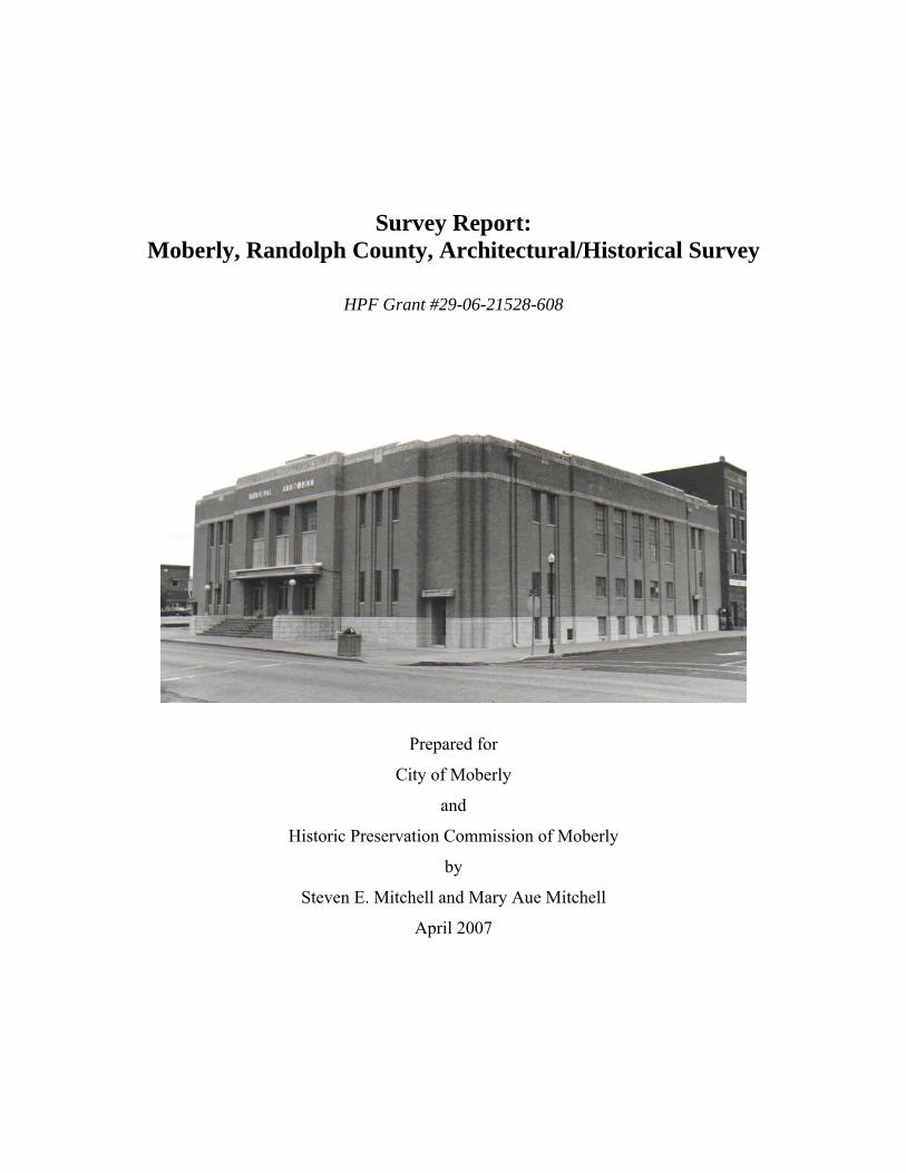
Survey Report: Moberly, Randolph County, Architectural/Historical Survey
HPF Grant #29-06-21528-608
Prepared for
City of Moberly
and
Historic Preservation Commission of Moberly
by
Steven E. Mitchell and Mary Aue Mitchell
April 2007
Moberly Architectural/Historic Survey Survey Report
Page ii
Table of Contents I. Objectives . . . . . . . . . . . . . . . . . . . . . . . . . . . . . . . . . . . . . . . . . . . . . . . . . . . . . . . . . . . . . . 1 II. Geographical Description and Historic Contexts . . . . . . . . . . . . . . . . . . . . . . . . . . . . . . . . 1 Moberly and Its Railroads, 1866—1872. . . . . . . . . . . . . . . . . . . . . . . . . . . . . . . . . . . . . . . 3 Moberly Business and Industry, 1873—1909 . . . . . . . . . . . . . . . . . . . . . . . . . . . . . . . . . . 12 Omar N. Bradley and Moberly, 1908—1911 . . . . . . . . . . . . . . . . . . . . . . . . . . . . . . . . . . . 18 Ludwig Abt and Twentieth Century Architecture in Moberly, 1910—1965 . . . . . . . . . . . 25 III. Methodology . . . . . . . . . . . . . . . . . . . . . . . . . . . . . . . . . . . . . . . . . . . . . . . . . . . . . . . . . . . . 31 IV. Results and Recommendations . . . . . . . . . . . . . . . . . . . . . . . . . . . . . . . . . . . . . . . . . . . . . . 33 Selected Bibliography . . . . . . . . . . . . . . . . . . . . . . . . . . . . . . . . . . . . . . . . . . . . . . . . . . . . . 46
Figures Figure 1: North Missouri Railroad advertisement . . . . . . . . . . . . . . . . . . . . . . . . . . . . . . . . . . . . 4 Figure 2: 1876 Moberly Map . . . . . . . . . . . . . . . . . . . . . . . . . . . . . . . . . . . . . . . . . . . . . . . . . . . . 9 Figure 3: 1891 Map Showing Wabash System in Missouri . . . . . . . . . . . . . . . . . . . . . . . . . . . . 11 Figure 4: Brown Shoe Company, Plant No. 6, Moberly . . . . . . . . . . . . . . . . . . . . . . . . . . . . . . 18 Figure 5: Omar Bradley, Time Magazine, May 1, 1944 . . . . . . . . . . . . . . . . . . . . . . . . . . . . . . . 24 Figure 6: Ludwig Abt. . . . . . . . . . . . . . . . . . . . . . . . . . . . . . . . . . . . . . . . . . . . . . . . . . . . . . . . . . 26 Figure 7: First Baptist Church, 514 West Rollins Street . . . . . . . . . . . . . . . . . . . . . . . . . . . . . . 45 Figure 8: Coates Street Presbyterian Church, 601 West Coates Street . . . . . . . . . . . . . . . . . . . 45
Tables Table 1: Population of Moberly, 1900-2000 . . . . . . . . . . . . . . . . . . . . . . . . . . . . . . . . . . . . . . . . 28 Table 2: Property Types Listed by Exterior Materials . . . . . . . . . . . . . . . . . . . . . . . . . . . . . . . . . 34
Appendices Appendix 1: Summary List of Surveyed Properties . . . . . . . . . . . . . . . . . . . . . . . . . . . . . . . . . . 48 Appendix 2: Summary List of Properties Recommended as Eligible . . . . . . . . . . . . . . . . . . . . 51 Appendix 3: Streetscape Views . . . . . . . . . . . . . . . . . . . . . . . . . . . . . . . . . . . . . . . . . . . . . . . . . . 55
Maps (following page 71)
Moberly Downtown Commercial Historic District, Inventory #s 1-15, 18-64, 66-67, 71-75, 80-81; and The Levee Historic District, Inventory #s 16-17 and 65
#68, Pacific Express Company Building, N. Sturgeon #69, Second Baptist Church, 314 N. Fifth; and #70, Grant Chapel AME, 411 N. Fifth #76, Bradley House #1, 119 S. Tannehill #77, Bradley House #2, 604 S. Fourth #78, Bradley House #3, 1226 Myra #79, Quayle House, 605 S. Fourth #82, Junior High School, 101 N. Johnson
Moberly Architectural/Historic Survey Survey Report
Page 1
I. Objectives
The initial objective of the Moberly historic/architectural survey was to identify, photograph, and
describe on inventory forms approximately sixty-nine historic properties that retained integrity
and represented one or more historic themes or trends significant in the development and
persistence of Moberly. Those properties selected for this inventory would then be evaluated to
further identify those eligible, either individually or as part of a district, for listing in the National
Register of Historic Places.
A total of eighty-one properties were eventually surveyed and a Missouri State Historic
Preservation Office (SHPO) Architectural/Historical Inventory Form completed for each
property. In addition, at least one five inch by seven inch black and white photograph documents
each property. Individual properties and a recommended historic district were mapped on a large
scale (at least one inch equals two hundred feet) map, and a final survey report, including historic
context, analysis of property types, evaluations of properties based on the National Register
Criteria of Eligibility, and recommendations for registration and additional survey was prepared.
II. Geographical Description and Historic Contexts
Most of the original properties proposed for survey were within an area roughly bounded on the
north by Hagood Street, on the south by Ault Street, on the east by Taylor and Sturgeon streets,
and on the west by Logan Street. The survey area included the original, historic commercial area
of the town. The majority of the properties included in the final report were along the 200 blocks
of North Coates, North Williams, North Fourth, North Fifth, and North Johnson streets; along the
100 through 500 blocks of West Reed Street; and along the 100 through 500 blocks of West
Coates Street.
According to Will Rothwell, in the Encyclopedia of Missouri (1901), Moberly was “situated
upon the highest point in Randolph County, and rests upon the topmost summit of the great
Moberly Architectural/Historic Survey Survey Report
Page 2
divide separating the basin of the Mississippi River from that of the Missouri.”1 From its
conception, Moberly was a railroad town, its location selected, its commerce sustained, and its
geography shaped by the converging rail lines. In his description of the town, Rothwell defined
it by the rail lines upon which it was located and its relation to the nearest rail centers:
. . . [Moberly was] situated on the Wabash and the Missouri, Kansas & Texas Railways,
148 miles from St. Louis, 128 miles from Kansas City, 131 miles from Ottumwa, Iowa,
and seventy miles from Hannibal, Missouri. It is the junction point of the main line of
the Wabash Railroad system from St. Louis to Kansas City, and the north branch of the
same system from Moberly to Des Moines, Iowa, and the main line of the Missouri,
Kansas & Texas Railway.2
According to geographer John C. Hudson, a railroad town was one element in the strategy of a
railroad "to populate and control the territory along its line." Despite whether the town
succeeded or, like most railroad towns, failed, it represented a portion of the corporation's larger
efforts "to manipulate people and resources, to command space and consolidate position, in order
to maximize profits for the company" by creating and controlling business along the line.3 Most
railroad towns were conceived as trade centers. Their businesses served the surrounding
population of farmers, who, in turn, supplied the agricultural products that were shipped on rail
lines and sustained the railroads.
Missourians were eager to explore the possibilities of rail transportation, holding their first
railroad convention in 1836, six years after the first U.S. railroad, the Baltimore & Ohio began
operation. Progress was not rapid, however. Sixteen years later, Missouri's first railroad, the
Pacific, had only completed a five-mile stretch of track. By the beginning of the Civil War, the
Missouri General Assembly had granted charters for 104 railroad lines, most of which were
1 Will A. Rothwell, "Moberly," in Howard L. Conard, ed., Encyclopedia of the History of Missouri, 6 vols. (New York: Southern History Company, 1901), p. 442. 2 Rothwell, pp. 441-442. 3 John C. Hudson, "Towns of the Western Railroads," Great Plains Quarterly 2 (Winter 1982), pp. 42-43.
Moberly Architectural/Historic Survey Survey Report
Page 3
never built.4 With the proliferation of rail lines large and small, access to a railroad became a
determinant of success for most towns, but the history of railroad colonization and town
formation in Missouri remains largely unwritten.
Moberly and Its Railroads, 1866--1872
The early history of Moberly was synonymous with much of the history of the two major
railroads constructed in northern Missouri. On February 16, 1847, the Hannibal & St. Joseph
Railroad was chartered. Twelve years later, in 1859, the route was completed, the first line to
extend across the state.5 The Hannibal & St. Joseph was also the first line completed in north
Missouri and passed north of Randolph County, as close as neighboring Macon County. On
March 1, 1851, the North Missouri Railroad was chartered and authorized to build a road from
St. Louis, through St. Charles, along the dividing ridge of the Missouri and Mississippi river
watersheds, to the Iowa line and Des Moines. In August 1855, the railroad was completed to St.
Charles. By August 1857, it reached Warrenton; in May 1858, it extended to Mexico; and, in
February 1859, it was completed to Macon and a junction with the Hannibal & St. Joseph.6
In 1858, the Chariton & Randolph Railroad Company was incorporated to construct a railroad
from Brunswick, in Chariton County, to a point on the still incomplete North Missouri line in
Randolph County. On December 5, 1859, the Missouri General Assembly incorporated the
Missouri River Valley Railroad to construct a line from a point on the North Missouri Railroad
in Randolph County, through Brunswick, Chariton County, to Weston, Platte County. Between
the North Missouri Railroad and Brunswick, the Missouri River Valley Railroad overlapped with
that of the Chariton & Randolph Railroad. On July 4, 1860, William Roberts, who owned a
4 Donald B. Oster, "The Hannibal and St. Joseph Railroad, Government and Town Founding, 1846-1861," Missouri Historical Review 87 (July 1993): 404-405. 5 Oster, p. 406; and Paul W. Gates, "The Railroads of Missouri, 1850-1870," Missouri Historical Review 26 (October 1931): 130. 6 Ralph E. Gerhard, The Early Day History of Moberly, Missouri, 3 vols., volume 2: 1868—1869—1870 (Moberly, MO: Randolph County Historical Society, n.d.), pp. 3-4.
Moberly Architectural/Historic Survey Survey Report
Page 4
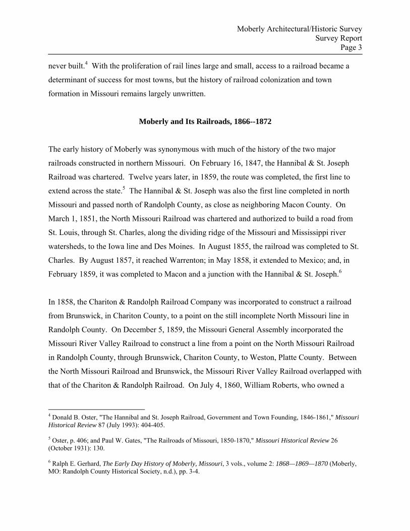
Figure 1: North Missouri Railroad advertisement that referenced stage connections at Allen. Source: Heimberger, p. 14.
Moberly Architectural/Historic Survey Survey Report
Page 5
substantial portion of the land where the city of Moberly would eventually rise along the route of
the North Missouri Railroad, negotiated an agreement with the Chariton & Randolph Railroad.
The terms of the agreement included the requirement that the railroad would locate its line on
Roberts's land, would plat a town at the junction of the two rail lines, and Roberts and the
railroad would share in the proceeds of the auction of the town lots. Further, the agreement
specified that the new town lots would be marketed as soon as possible.
The nearest settlement to the proposed town was Allen, little more than a post office and a few
buildings at the junction of the stage road from Glasgow to Paris and the North Missouri
Railroad. Although Allen was initially considered for the junction of the two railroads, it was
snubbed in favor of a point about one mile south on the North Missouri. The new town site was
named Moberly, for Chariton & Randolph president William E. Moberly of Brunswick in
Chariton County.7 In order to interest the residents of Allen in the new town site, the directors of
the Chariton & Randolph Railroad offered any person who owned land in Allen a similar amount
in the new junction town.
In a series of events that seem apocryphal, only one resident of Allen accepted the offer of the
Chariton & Randolph. Patrick Lynch, a thirty-six year old Irish laborer, dragged his house to the
offered land, Lots 11 and 12 in Block 12 (the south side of Reed Street, near the alley running
north and south between Sturgeon and Clark streets), at the new town site. Lynch remained the
only inhabitant of the phantom town for the duration of the Civil War,8 eventually plowing over
the surveyor's stakes and farming a large part of the platted but unpeopled town. After the war,
7 William E. Moberly, born about 1822, was a native of Madison County, Kentucky, the son of John Moberly. By 1850, he lived in Brunswick, Chariton County, Missouri, with his wife, Martha, also a native of Kentucky. Moberly was a merchant, with property valued at $2,000. By 1860, Moberly's fortunes had improved considerably. His occupation was listed as lawyer, and he owned real estate valued at $70,000 and personal property valued at $19,300. He and Martha had three children. During the Civil War, Moberly served successively as a Captain, Lieutenant Colonel, and Colonel of the 35th Regiment Enrolled Missouri Militia. Ten years later, Moberly and his family lived at No. 1717 Christy Avenue in St. Louis. He worked as a real estate dealer, with his own real estate holdings valued at $300,000 and personal property valued at $20,000. 8 According to the 1860 census, taken on August 28 while Lynch was a resident of Allen, his household consisted of his wife; one daughter, 5, and two sons, 4 and 2; and two boarders, both laborers. It was not specified whether all his household members followed Lynch to Moberly or remained in Allen.
Moberly Architectural/Historic Survey Survey Report
Page 6
Lynch was awarded Lots 11 and 12 for the cost of the one dollar recorder's fee, in consideration
of his having "'held the city during the war without the loss of a life or a house.'"9
On February 10, 1864, the General Assembly authorized the Missouri River Valley and Chariton
& Randolph railroads, subject to the approval of the majority of their stockholders, to assign all
their interests to the North Missouri Railroad. Upon such action, the two lines would cease to
exist and their routes would be designated the West Branch of the North Missouri Railroad, to
begin at the still un-established town of Moberly.10
On April 28, 1864, the Chariton & Randolph Railroad sold its assets, including its interest in the
proposed Moberly town site, to the North Missouri Railroad. In July 1866, the new owners
resumed construction on the former Chariton & Randolph, now the West Branch of the NMRR,
which was completed in 1868 to Birmingham, Missouri, near Kansas City.11 The original town
site was more substantial in size than most fledgling Missouri towns. It consisted of four blocks
south of the railroad and north of Franklin Street; five full blocks and five half blocks to the west
of the railroad and bordered by Wightman Street on the south to the railroad on the north; and
fourteen blocks east of the railroad, from Sturgeon Street on the west to Morley Street on the
east, and from Wightman Street on the south to a township road on the north. The first sale of
lots in the re-surveyed town site was held on September 27, 1866. The first sale was less than a
resounding success; in the summer of 1867, there were still less than a hundred residents of the
town and a second sale was deemed necessary. On May 25, 1868, the Randolph County Court
incorporated the town of Moberly and appointed a board of trustees. On April 17, 1869, the city
held its first elections.
Little time passed before entrepreneurs moved to take advantage of the nascent city's position on
a major railroad. After the first lot sale, S.P. Tate began construction of a two-story, frame hotel
9 History of Randolph and Macon Counties (St. Louis: National Historical Company, 1884), p. 181. 10 Ray County v. Vansycle (96 U.S. 675), pp. 677-679. 11 Gerhard, 3:8.
Moberly Architectural/Historic Survey Survey Report
Page 7
at the southwest corner of Clark and Reed streets. However, a second hotel, the American Hotel
(or the Grimes Hotel) on Sturgeon Street, constructed by John Grimes, was completed before
Tate's.12
In the ensuing two years, Moberly saw a respectable expansion of the number of its commercial
concerns. In 1869, the Moberly Herald published a directory of twenty-nine businesses, located
primarily on Coates, Clark, Reed, Sturgeon, and Williams streets. The businesses included two
dry goods stores, two milliners, two groceries, a meat market, a druggist, a hardware store, three
real estate agents, four building contractors, a hotel, two doctors, a dentist, and two saloons. The
list may not have been complete, since John Grimes's American Hotel was not listed:
J.J. & G.W. Jones, dry goods, Coates Street, east of railroad T.P. White, dry goods and clothing, corner Clark and Reed streets Mrs. Foose, milliner, south side of Reed Street Mrs. E. Werden, milliner, north side Reed Street Berry & Harmon, groceries, Clark Street E.H. Miller, grocery and bakery, Sturgeon Street H. Overberg, meat market, Reed Street William Seelen, hardware and cutlery, Reed Street B.Y.N. Clarkson, reapers, mowers and threshers, Reed Street Chandler & Adams, druggists, corner Reed and Clark streets L. Brandt, boots and shoes, corner Reed and Sturgeon streets William E. Grimes, real estate, south side Reed Street J.D. Werden, real estate and insurance, Reed Street I.B. Porter, attorney at law, real estate and insurance agent, Reed Street North Missouri Coal & Mining Company, Sturgeon Street J.S. Clarkson & Company, fruit trees, hedge and shrubbery, Reed Street E.H. Petering, lumber and builder, Williams Street True & Briggs, contractors and builders, Clark Street Joseph Anson, carpenter and builder, Williams Street J.D. Bailey, carpenter and builder, Williams Street J.H. McQuaid, lumber dealer, Moulton Street east of railroad W.K. Christian, dentist, Fifth Street (residence) Dr. J.C. Tedford, physician, Coates Street Dr. C. Adams, physician, corner Clark and Reed streets Tate's Hotel, S.P. Tate, proprietor, corner Clark and Reed streets William Teeters, restaurant, Reed Street O.N. Kaan, barber and hair dresser, Reed Street
12 History of Randolph and Macon Counties, pp. 181-182.
Moberly Architectural/Historic Survey Survey Report
Page 8
Manlin & Company, saloon, southwest corner Reed and Sturgeon streets P. McLarney, Moberly Saloon, Sturgeon Street13
By 1870, only three years after the first lot sale, the population of Moberly had reached an
impressive 1,521.14 However, Moberly’s businessmen and city leaders may have been aware
that most railroad towns were failures, and hundreds of towns founded upon bright promises
stagnated or withered and died in the late nineteenth and early twentieth centuries. The towns
were spaced on average every seven to ten miles along rail lines, so growth of any town could
only be at the expense of its neighbors. Moberly residents quickly resolved that their town
would not only persist but also prosper. Perhaps because the creation of their town was the act
of a railroad, the citizens of Moberly determined that stronger ties to the North Missouri Railroad
and connections with additional rail lines promised the best chances for the continuance and
growth of the town. As early as 1868, some citizens of Moberly began agitating for the location
of machine shops of the NMRR in their town and offered the railroad the choice of three tracts of
land, each about sixty acres, as a site for the shops. At an election held August 31, 1869, the
offer of land was increased to one hundred acres. In 1870, two additional elections were held to
authorize the acquisition of a 104-acre tract; the first election was ruled unlawful, but the second
approved the purchase. On March 25, 1871, yet another election was held to approve the
purchase and donation of two tracts, one of two hundred acres, for the location of the machine
shops, and one of 618 acres, and to exempt both tracts from city taxes for twenty years. As
tangible evidence of the town's growth, in 1871, the following parcels were added to Moberly:
Hunt and Godfrey’s Addition; Hunt, Godfrey and Porter’s Addition; Young and Stephen’s
Addition; Robert’s Addition; Porter’s Addition; and Burkholder and True’s Addition.15
13 John E. Lynch, comp., Moberly Fifty Years Ago—and To-Day (Moberly: Democrat, 1916; reprint ed., Moberly: Randolph County Historical Society, n.d.), n.p. History of Randolph and Macon Counties (p. 182) provided a slightly different list of early businesses: “Dry goods, Tate & Bennett; drugs, O.F. Chandler; groceries, — Lampton, who was immediately succeeded by Martin Howlett; hardware, William Seelen; furniture, H.H. Forcht, and, immediately after, J.G. Zahn, both houses being owned by E.H. Petering; lumber, sash, doors and blinds, H.H. Forcht for E.H. Petering; jewelry, John N. Dring; livery, White Bros.; clothing, Levy & Krailsheimer; boots and shoes, L. Brandt; butcher, Henry Overberg; barber, O.N. Kaare.” 14 Ralph E. Gerhard, The Early Day History of Moberly, Missouri, volume 2: 1868—1869—1870, 3 vols. (Moberly, MO: Randolph County Historical Society, n.d.), p. 70. 15 History of Randolph and Macon Counties, pp. 183-185; and Gerrhard, 3:58.
Moberly Architectural/Historic Survey Survey Report
Page 9
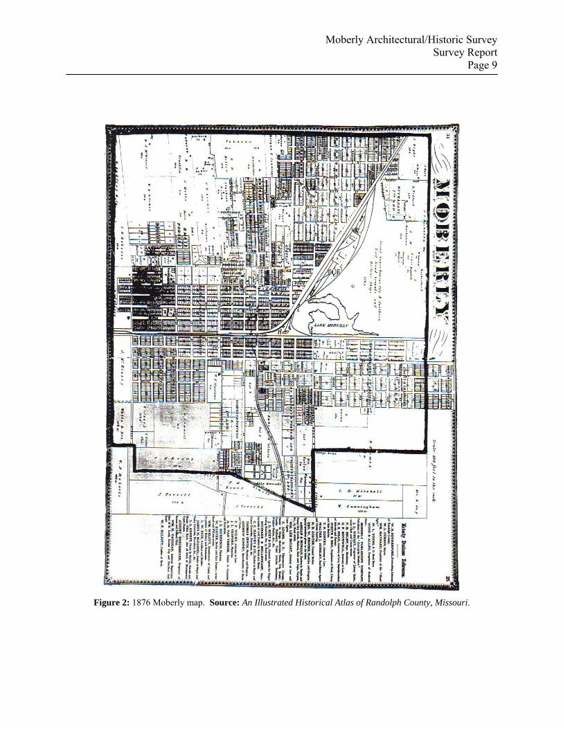
Figure 2: 1876 Moberly map. Source: An Illustrated Historical Atlas of Randolph County, Missouri.
Moberly Architectural/Historic Survey Survey Report
Page 10
According to historian Ralph E. Gerhard, “1872 [was] the most important year in the whole
history of Moberly, Missouri,”16 as its quest for additional railroads and rail facilities succeeded.
On January 16, 1860, the Tebo and Neosho Railroad was chartered to construct a line from
Sedalia in a southerly or southwesterly direction to the Missouri-Kansas state line. The charter
also secured the right for the railroad to build in a northeasterly direction from Sedalia. In an
election held January 4, 1871, the citizens of Sugar Creek Township, which included Moberly,
voted to subscribe $65,000 in bonds to the Tebo & Neosho, provided that railroad built its line to
Moberly. In January 1872, it was confirmed that the Tebo & Neosho's seventy-two mile long
Northeastern Extension would connect with the St. Louis, Kansas City and Northern Railroad
(the former North Missouri Railroad) at Moberly. On March 23, 1872, the Tebo & Neosho was
acquired by the Missouri, Kansas & Texas Railroad (MKT), and, later that year, construction
was complete to Moberly. On August 10, 1873, through service began. The same year, the
MKT purchased the Hannibal and Central Railroad, a seventy-mile short line completed in
August 1871 between Hannibal and the Tebo and Neosho connection at Moberly. Chartered in
1867 as the Hannibal and Moberly, the railroad had been leased since 1871 to the Toledo,
Wabash and Western.17
On March 26, 1872, the citizens of Moberly once again approved the subsidies previously
offered the St. L, KC & N's predecessor, and, by early April, both parties to the agreement had
signed a contract that was the culmination of four years’ efforts to transform the city into a
railroad center. In November 1879, the St. Louis, Kansas City and Northern merged with the
Toledo, Wabash and Western to form the Wabash, St. Louis and Pacific, which, after several
additional reorganizations over the next ten years, became the Wabash Railroad.18
16 Gerhard, 3:73. ` 17 Gerhard, 3:19-20, 32-32, 40, and 74; V.V. Masterson, The Katy Railroad and the Last Frontier, with a new forward by Donovan L. Hofsommer (Norman: University of Oklahoma Press, 1942; reprint ed., Columbia: University of Missouri Press, 1988), pp. 36 and 196; and Cass County v. Gillett, 100 U.S. 585, p. 586. On August 1, 1923, the former Hannibal and Central route was leased to the Wabash, which purchased the line on December 15, 1944. Masterson, pp. 284-285. In 1964, the Wabash merged with the Norfolk & Western. 18 Donald Heimburger, Wabash (River Forest, IL: Heimburger House Publishing Company, 1984), p. 29.
Moberly Architectural/Historic Survey Survey Report
Page 11
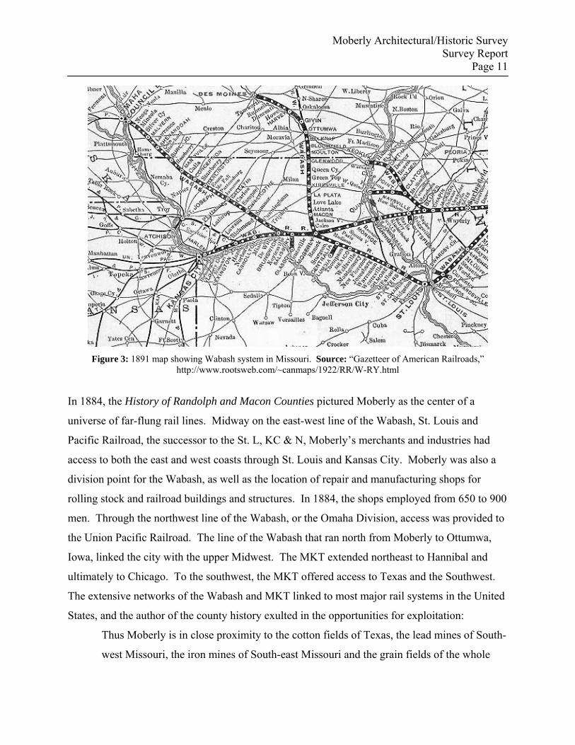
Figure 3: 1891 map showing Wabash system in Missouri. Source: “Gazetteer of American Railroads,”
http://www.rootsweb.com/~canmaps/1922/RR/W-RY.html
In 1884, the History of Randolph and Macon Counties pictured Moberly as the center of a
universe of far-flung rail lines. Midway on the east-west line of the Wabash, St. Louis and
Pacific Railroad, the successor to the St. L, KC & N, Moberly’s merchants and industries had
access to both the east and west coasts through St. Louis and Kansas City. Moberly was also a
division point for the Wabash, as well as the location of repair and manufacturing shops for
rolling stock and railroad buildings and structures. In 1884, the shops employed from 650 to 900
men. Through the northwest line of the Wabash, or the Omaha Division, access was provided to
the Union Pacific Railroad. The line of the Wabash that ran north from Moberly to Ottumwa,
Iowa, linked the city with the upper Midwest. The MKT extended northeast to Hannibal and
ultimately to Chicago. To the southwest, the MKT offered access to Texas and the Southwest.
The extensive networks of the Wabash and MKT linked to most major rail systems in the United
States, and the author of the county history exulted in the opportunities for exploitation:
Thus Moberly is in close proximity to the cotton fields of Texas, the lead mines of South-
west Missouri, the iron mines of South-east Missouri and the grain fields of the whole
Moberly Architectural/Historic Survey Survey Report
Page 12
trans-Mississippi Valley. It is on the direct line of travel between New York and San
Francisco; it is located on one of the railroads that carry the products of the great South-
west to the great St. Louis, Chicago and eastern markets. It stretches its iron arms into
remote territories and enables the manufacturer to ship his wares direct from this point to
almost every prominent place on the continent, and especially to the thriving towns and
villages of the West.19
Moberly Business and Industry, 1873—1909
Once the immediate future of the town seemed secure, other institutions associated with
permanent, healthy settlement quickly followed. In 1872, the first graded public school was
organized in Moberly. Classes were originally conducted on the second floor of the Rothwell
and Porter Block at the northwest corner of Reed and Fourth streets. In 1876, Central School
was constructed at Johnson and Rollins streets; it burned in 1894. In March 1873, the General
Assembly approved a special act incorporating the city of Moberly, and the previous
incorporation was abandoned. In March 1889, the citizens of Moberly voted to relinquish the
special incorporation and organize under general state law as a city of the third class. In 1873, a
gas works was established. In 1874, a fire swept West Reed Street from North Clark to the
depot. In 1875, the General Assembly established by special act a Court of Common Pleas in
Moberly, and one-half of all county courts were held in Moberly, with alternate terms in the
county seat, Huntsville. In 1876, and again in 1882, efforts were mounted to relocate the county
seat from Huntsville to Moberly. In both cases, the measure received a majority of votes but fell
short of the two-thirds vote needed to effect the change. Reflective of the rapid growth of
Moberly, the first modern infrastructure improvements appeared within the first decade. In
1881, a telephone exchange was established. Work began on a city sewer system in 1884, and
by 1901 there were about fifteen miles of sewers. In 1885, a waterworks was established.20 In
19 History of Randolph and Macon Counties, pp. 186-188. 20 Rothwell, 4:449.
Moberly Architectural/Historic Survey Survey Report
Page 13
1888, the first vitrified brick street paving was laid, and an electric light plant was in operation;
by 1894, an enlarged electric plant provided power for appliances other than lights.
In 1890, a $30,000 hospital for Wabash Railroad employees was built. The railroad also
maintained a one thousand volume library for its employees. In 1892, a $12,000 city hall was
constructed, and in 1889, a union station to serve the two major rail lines was built at a cost of
$35,000. In 1900, a Y.M.C.A. building for railroad employees was constructed. By the opening
of the twentieth century, Moberly businesses included an eight hundred seat opera house; three
large hotels and an unspecified number of smaller hotels and boarding houses; two daily and five
weekly newspapers; two banks; two building and loan associations; two brick factories, which
manufactured and shipped hundreds of carloads of paving brick, building and ornamental brick,
tiling, sewer and drainage pipe, and earthenware; an iron foundry; two non-railroad machine
shops; a flour and feed mill; a saw and planing mill; an ice plant, with connected cold storage;
two steam laundries; five cigar factories; grocery, drug, oil, cigar, and confectionary wholesalers;
and approximately two hundred other stores and businesses.21
According to the 1884 county history, vast beds of coal underlay all of Randolph County, and, in
1900, another writer averred that Moberly was "the center of one of the greatest coal-mining and
shipping regions in Missouri, and coal is mined in vast quantities within sight of the city
limits."22 Within the county, mine shafts were located at Renick; Higbee; Bevier; between
Moberly and Huntsville, less than a mile northwest of Moberly; and even within the limits of the
city. One of the more famous mining locations was Monkey’s Nest, near Moberly, the
birthplace, on December 5, 1898, of proletarian writer and editor John Wesley “Jack” Conroy.23
21 Rothwell, 4:450; and History of Randolph and Macon Counties, p. 188. 22 Rothwell, 4:450. 23 "John Wesley ‘Jack’ Conroy Clippings, 1933-1966,” Department of Special Collections and Archives, Kent State Libraries and Media Services, http://speccoll.library.kent.edu/literature/prose/conroy.html, accessed December 16, 2006; and “Jack Conroy Biographical Data,” Jack Conroy American Studies Collection, Kate Stamper Wilhite Library, Moberly Area Community College, http://www.macc.cc.mo.us/~conroy/bio.htm, accessed December 16, 2006.
Moberly Architectural/Historic Survey Survey Report
Page 14
At the peak of production in Randolph County, over 1,500 men produced about one million tons
of coal per year.24
By 1900, the population of Moberly was 8,012. The State of Missouri: An Autobiography
described Moberly as Randolph County's "chief city" and "one of the most important railroad
centers of north Missouri." Moberly had settled comfortably into its role as a rail center and
railroad town. According to the Autobiography,
From five directions trains enter [Moberly's] union station. The main western
shops of the Wabash railroad are located here where are also the offices of three
main divisions of the road. Two divisions of the Missouri, Kansas & Texas meet
here.25
On April 2, 1901, Moberly voters approved a one-mill tax to support a city library. This was not
the first effort to provide a library for the community. In November 1872, the Moberly Library
Association, a group of citizens with no official affiliation, opened a small reading room with a
collection of 335 books and eight magazines. Membership was $5.00 a year. The association
lasted only three years. The second attempt was by railroad employees, who formed the
Railroad Library Club. Their attempts to form a permanent library were also unsuccessful. For
the new efforts, the Railroad Library Club donated its small collection and fixtures, and, on
August 1, 1901, the city library was opened in the space previously occupied by the Railroad
Library Club.
In January 1902, Moberly Mayor Willard P. Cave wrote Andrew Carnegie requesting a library
building. On April 26, 1902, Carnegie’s staff responded that, if the City Council would pledge
by resolution to support a free public library in the amount of not less that $1,500 a year and
provide a suitable location, Carnegie would contribute $15,000 towards a building. Later, the
amount of city support was raised to $2,000 a year, and Carnegie's donation increased to 24 History of Randolph and Macon Counties, p. 285. 25 Walter Williams, ed., The State of Missouri: An Autobiography (Columbia: Press of E.W. Stephans, 1904), pp. 490-491.
Moberly Architectural/Historic Survey Survey Report
Page 15
$20,000. The Moberly library was one of thirty-three Carnegie libraries constructed in twenty-
six Missouri communities. Grants awarded in Missouri ranged from $5,000, for the Marshfield
library, to $500,000, for the St. Louis City central library.
Missouri received $1,460,143 of Carnegie grants for public library buildings during the period
1898-1919, ranking ninth in the states by the total amount contributed. Nationwide, Missouri
ranked seventeenth in number of libraries constructed, as well as seventeenth in number of
communities that received libraries. The earliest Carnegie pledges in Missouri were made
between 1899-1903, with the later ones between 1910-1917. According to statistics published in
1967 and updated by Jones in 1997, of the thirty-three Carnegie public library buildings in
Missouri, twenty-nine were still being used as a library and one had been demolished. A
statewide survey of Carnegie public library buildings has not been undertaken. However, there
are five Carnegie library buildings listed individually in the National Register of Historic Places
(Albany, Joplin, Louisiana, Saint Joseph, and Sedalia) and seven within historic districts (one
each in districts in Jefferson City, Carthage, and Fayette, and one in each of four districts in St.
Louis). Carnegie library buildings in Aurora and Mexico have been determined eligible for
listing.27
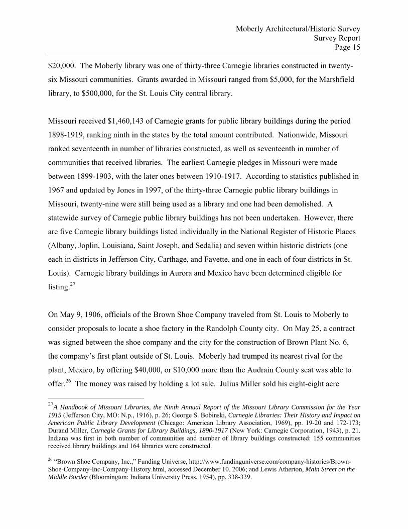
On May 9, 1906, officials of the Brown Shoe Company traveled from St. Louis to Moberly to
consider proposals to locate a shoe factory in the Randolph County city. On May 25, a contract
was signed between the shoe company and the city for the construction of Brown Plant No. 6,
the company’s first plant outside of St. Louis. Moberly had trumped its nearest rival for the
plant, Mexico, by offering $40,000, or $10,000 more than the Audrain County seat was able to
offer.26 The money was raised by holding a lot sale. Julius Miller sold his eight-eight acre
27A Handbook of Missouri Libraries, the Ninth Annual Report of the Missouri Library Commission for the Year 1915 (Jefferson City, MO: N.p., 1916), p. 26; George S. Bobinski, Carnegie Libraries: Their History and Impact on American Public Library Development (Chicago: American Library Association, 1969), pp. 19-20 and 172-173; Durand Miller, Carnegie Grants for Library Buildings, 1890-1917 (New York: Carnegie Corporation, 1943), p. 21. Indiana was first in both number of communities and number of library buildings constructed: 155 communities received library buildings and 164 libraries were constructed.
26 “Brown Shoe Company, Inc.,” Funding Universe, http://www.fundinguniverse.com/company-histories/Brown-Shoe-Company-Inc-Company-History.html, accessed December 10, 2006; and Lewis Atherton, Main Street on the Middle Border (Bloomington: Indiana University Press, 1954), pp. 338-339.
Moberly Architectural/Historic Survey Survey Report
Page 16
Miller Park Fairgrounds, located in southeast Moberly, to Amos Gibson for $24,000. Gibson
represented the Committee of Citizens, formed to lure a shoe factory to Moberly. The eighty-
eight acre parcel was divided into eighteen blocks and 336 lots. Citizens paid two hundred
dollars for each lot, with the final selection of lot location made by lottery. The sale yielded
$67,200, which earned the Committee $43,200 after the $24,000 paid for the Miller parcel was
deducted.
The agreement between the Brown Company and Moberly specified that Moberly would pay
Brown $40,000 and provide a site for the factory building; connect the facility with water, gas,
and electricity; construct a walk from the plant to the nearest, most accessible paved street; and
guarantee that city taxes would not exceed $75.00 per year for the next five years. In return, the
Brown Shoe Company agreed to construct the factory building; hire 300 or more employees;
increase the payroll consistent with business increases; operate the facility for ten years or more;
and, if the facility was ever closed, the building and site would revert to the city.27
As early as 1860, the boot and shoe industry was a significant component in Missouri's
burgeoning industrial development. In that year, the industry ranked fourth in value of
manufacturers in the state. Beginning about 1890, however, "extensive development," or large-
scale mechanization of the boot and shoe industry began and substantial amounts of capital were
invested.28 With the shift from small-scale production to mass production, over the next ten
years, the amount of capital required for production of one hundred dollars of product declined
more than one-half, from $76.70 in 1890 to $37.18 in 1900. During the same period, the value
of products manufactured increased $6,412,198, while the capital required increased only
$471,064. By 1897, St. Louis had twenty-six boot and shoe factories that employed 5,500
workers and paid $2,500,000 in wages. By 1909, the fifty-nine establishments that manufactured
boots, shoes, cut stock, and findings employed 17,396 workers, more than any other Missouri
industry. The industry's national ranking also reflected its pronounced growth. In 1899, the 27 Moberly, Missouri: 100th Anniversary History, 1866-1966 (n.p., n.d.), pp. 56-57. 28 U.S. Department of Commerce, Census Office, Twelfth Census of the United States, Taken in the Year 1900: Manufactures, part 3, Special Reports on Selected Industries, p. 753.
Moberly Architectural/Historic Survey Survey Report
Page 17
Missouri boot and shoe industry ranked eighth among the states. By 1904, it was fourth, and, by
1909, it was ranked second in the country.29
With few exceptions, from its introduction in Missouri, the boot and shoe industry had been
centered in St. Louis. In 1900, the boot and shoe manufacturing establishments in St. Louis
accounted for 78 percent of the value of products manufactured in that industry in the entire
state, and, by 1904, St. Louis still retained twenty-two of the thirty-seven boot and shoe factories
in Missouri. As early as 1899, some relocation from St. Louis into the rest of the state and into
neighboring states had begun. Primarily an effort to obtain cheaper labor, the major exodus
began after 1906 and continued to increase after World War I. By 1928, the five largest St.
Louis shoe companies had established plants in fifty-six small towns within a two hundred mile
radius of St. Louis, employing over 30,000 workers.30
In 1878, in St. Louis, partners George Warren Brown, Alvin Bryan, and Jerome Desnoyers
formed Bryan, Brown & Company to manufacture and market shoes. In 1893, the company's
name was changed to Brown Shoe Company. In 1904, the company scored a marketing coup
when the rights to Richard F. Outcault's cartoon character, Buster Brown, were purchased at the
St. Louis World's Fair. Brown Shoe hired a troupe of actors to dress as Buster Brown,
accompanied by his dog, Tige, and perform in shoe stores, department stores, and theaters. By
1906, Brown Shoe Company operated five factories in St. Louis. The Moberly plant was
Brown’s first factory outside of St. Louis.31 The Moberly plant operated until the 1950s. When
it closed, the city leased it to the Narragansett Gymnasium Company. The building was
demolished by the City of Moberly in 2005. 29 Ibid., pp. 745 and 753-754; Idem., Bureau of the Census, Thirteenth Census of the United States Taken in the Year 1910, volume 9, Manufactures, 1909: Reports by States, with Statistics for Principal Cities, pp. 636, 644-645, and 653; and Floyd Calvin Shoemaker, Missouri and Missourians: Land of Contrasts and People of Achievements, 5 volumes (Chicago: Lewis Publishing Company, 1943), 2:557. 30 U.S. Department of Commerce, Bureau of the Census, Census of Manufactures, 1914, volume 1: Reports by States with Statistics for Principal Cities and Metropolitan Districts, p. 788; and Rosemary Feurer, "Shoe City, Factory Towns: St. Louis Shoe Companies and the Turbulent Drive for Cheap Rural Labor, 1900-1940," Gateway Heritage 9 (Fall 1988): 5. 31 "Our History," Brown Shoe, http://www.brownshoe.com/history/index.asp, accessed December 13, 2006.
Moberly Architectural/Historic Survey Survey Report
Page 18
Figure 4: Brown Shoe Company, Plant No. 6, Moberly. Source: A Pictorial History of Moberly, Missouri, p. 36.
Omar N. Bradley and Moberly, 1908—1911
Moberly's most famous resident was General of the Army Omar Nelson Bradley, and four
residential properties associated with his tenure in Moberly are extant. Bradley lived in Moberly
less than four years, departing in 1911 for West Point. His mother remained in Moberly until her
death in 1931, and his military career provided little opportunity to visit the Randolph County
town after she died. On July 5, 1943, Moberly honored its favorite son, then preparing for the
invasion of Sicily, by naming its municipal airport for him, and, in 1956, by renaming the
remodeled and desegregated Lincoln School for the general. After World War II, Bradley
returned at least twice to Moberly, on the rededication of the airport, on June 9, 1945, which was
proclaimed Bradley Day, and, on September 23, 1966, during the centennial celebration, again
designated Bradley Day.
In 1909, the year after Omar Bradley and his mother moved to Moberly, the Democrat
Publishing Company, publisher of three Moberly newspapers, the Moberly Evening Democrat,
the Sunday Morning Democrat, and the Twice-A-Week Democrat, printed Moberly, Missouri:
The Magic City (titled Moberly 1909 on its cover). The booklet provided an idealized portrait of
Moberly Architectural/Historic Survey Survey Report
Page 19
the community and its prospects as it was in the first full year in which the future general lived
there and forty-three years after the first sale of lots in the nearly barren town site. According to
the anonymous author, his goal was “to present to the prospective newcomer and the stranger the
facts that have caused [Moberly’s] phenomenal growth and which may be of interest to him as a
future resident.”32
The city government was “in the hands of capable and wide-awake men" and the current slate of
officials were described as "The Booster Administration.” The publication's author claimed an
inflated population of 13,500, although the city would not achieve this figure for over twenty
years. The city owned the water system, and sewer districts had been planned and were
scheduled for completion by 1911. Moberly Gas and Electric Company served over eight
hundred customers. Among the attractions and accomplishments of the city were fifteen miles of
shady streets paved with vitrified paving blocks, “in the Lincoln style, lined with beautiful, well-
kept parkings on either side.” The paving blocks used, it was noted, were of Moberly brick made
from locally obtained shale and laid by local labor.
One purpose of the booklet was to showcase Moberly as a paradise for business and industry,
and an unflaggingly optimistic overview of the commercial life of the city in 1909 was painted
for the prospective resident or entrepreneur. The Wabash Railroad, which employed Omar in
1909 and 1910, was credited with contributing “largely toward making Moberly the best city
between Kansas City and St. Louis.” Moberly was the headquarters of the Moberly Division,
which encompassed all Wabash lines west of the Mississippi River; the site of the Wabash
shops; and the terminus of five Wabash lines. The value of the railroad’s property in Moberly
was estimated at one million dollars. The Wabash was probably Moberly’s largest employer,
with 1,775 men. Of that number, 1,050 worked in the shops, forty-five in the yards, seventy-five
in offices, 130 in the maintenance of way department, and 475 trainmen resided in Moberly.
32 Moberly, Missouri: The Magic City (Moberly, MO: Democrat Publishing Company, 1909). The pages are unnumbered.

Moberly Architectural/Historic Survey Survey Report
Page 20
The businesses and industries listed in Magic City were calculated to bolster the image of
Moberly as an established and expanding center of commerce. Many of the industries catered to
both the needs of a city still in its formative stage and to the miners or farmers in the surrounding
area who still struggled to exploit the largely underdeveloped resources. The Moberly Foundry
and Machine Company, established in 1906, manufactured mining equipment, as well as
architectural elements such as store fronts, including columns, lintels, sills, and beams. Moberly
Cornice Works, established by A. Kensteiner and purchased by Frank B. Wegs in January 1908,
also manufactured galvanized iron fronts, as well as pressed steel ceilings; copper work;
skylights; roofing, including tin, slate, asbestos, gravel, and ruberoid [sic]; gutters; spouting;
cresting; pressed steel brick; furnaces; and heating plants. Originally located at 111 North
Coates (destroyed by fire on January 16, 1911), in an ornate building that visually proclaimed
most of the firm’s architectural products, the business continued until 2006 under the name of
Wegs Sheet Metal Company (see form #9). The oldest company that produced architectural
features was P. Stauffer & Company, established in 1896. Located at 213-215 Sturgeon (not
extant), the company manufactured cornices, galvanized ironwork, and metal ceilings, and it also
dealt in slate, composition, tile, tin, and cement roofing.
The Corrugated Culvert Company specialized in the relatively new industry of corrugated,
galvanized iron culverts, and the Faessler Manufacturing Company, established in 1883 by J.
Faessler, produced boiler maker’s tools. Formed by the purchase of the Moberly Brick and
Earthenware Company in 1906, the Moberly Paving Brick Company may have provided some or
most of the paving for Moberly’s fifteen miles of paved streets. Fennel Carriage and Wagon
Works, founded in 1872 by William Fennel, was equipped to manufacture buggies, delivery
wagons, wagonettes, and farm wagons. One of the city’s larger employers, Brown Shoe,
received an abbreviated notice in Magic City. The producer of men’s and boy’s work shoes, it
was noted, “gives employment to hundreds of young men and women” (see Figure #4).
Moberly’s situation as a rail center encouraged the establishment of a number of firms that dealt
with agricultural products that could be distributed throughout the Midwest and beyond. Several
wholesale produce and grocery businesses operated from Moberly, including Davidson Brothers
Moberly Architectural/Historic Survey Survey Report
Page 21
Company, the Moberly branch of a Des Moines firm that specialized in fruits and other produce,
confectionary items, and tobacco; Franklin J. Overberg wholesale grocer, since 1908 the
successor to F. Hegarty & Brother (see form #6); Esry Richmond grocery at 217 North Clark
(not extant), with a warehouse on Coates; and O’Keefe Brothers Grocer Company. Other firms
distributed or refined other agricultural products or supplied feed for livestock: the McAfee Mill
& Commission Company dealt in hay, grass, flour, and meal, and it produced “Milk-O dairy feed
and Hosfat horse feed; F.M. Stamper Company, established in 1890 at Clifton and later relocated
to Moberly, dealt in poultry and eggs; the Millbank-Scampton Milling Company was established
in 1904; and D. White, Flour, formed in 1907 when White purchased the wholesale flour and
feed business of H.H. Wayland.
According to Magic City, the retail establishments of Moberly drew their trade from a fifty-mile
radius about the town. A selection or sampling of the city’s retail businesses, possibly inserted
as paid advertisements, was provided, including: Harlan’s Pharmacy, 401 West Reed (not
extant); Miss Laura Gregory, Millinery, 402 West Reed (altered; noncontributing); Hamilton
Abstract Company, 209 North Williams; Globe Mercantile Company, 408-410 West Reed,
which specialized in house furnishings; and Van Cleve, Martin, and Mahan, 209-213 North
Clark (see forms #12 and #13), furniture and undertaking. Other businesses noted in Magic City
were: Harlan’s Plumbing, 401 West Reed (not extant); People’s Laundry, purchased in 1899 by
H. Frank Holman; Hamilton Abstract Company, originally established at Huntsville, but its
branch office, 209 North Williams (not extant) was shared with Shivell and Victor, real estate;
John N. Taylor, pianos and organs, also originally established at Huntsville, but with a Moberly
branch since about 1889; Tedford Plumbing Company, 409 Reed (also see form #67),
established in 1900; the Bank of Moberly, organized in May 1895 and located on the first floor
of the building at the southwest corner of West Reed and North Williams (altered); and the
Moberly Trust Company, established July 30, 1906, which may have shared the building with
the Bank of Moberly.
Omar Nelson Bradley was born July 25, 1892, on the farm of his maternal grandparents, Mr. and
Mrs. Henry Clay Hubbard, three and one-half miles west of Clark, Randolph County, and about
Moberly Architectural/Historic Survey Survey Report
Page 22
fifty-five miles from General of the Armies John J. Pershing’s birthplace of Laclede, Linn
County. Bradley's parents were John Smith Bradley, a schoolteacher, and Sarah Elizabeth
“Bessie” Hubbard. At Omar's birth, on February 12, 1893, his father was teaching at a rural
school southwest of Sturgeon. In the fall of 1899, Omar began his formal education in a one-
room school, taught by his father, at Pemberton, Randolph County. The following year, his
father taught at Locust Grove School in Howard County. In 1903, the family moved to Boone
County, where his father taught at the Baldridge School, in Harrisburg. In 1905, when Omar was
twelve, the family returned to Randolph County, to Higbee.
In 1908, John Bradley was teaching at Ebenezer School when he contracted pneumonia. He died
on June 30 of that year. Later that year, Omar and his mother moved to Moberly (Omar’s name
was listed as Homer in the city directory). They first lived in a rented house at 119 South
Tannehill Street (form #76). Although Omar had completed his sophomore year in Higbee,
Moberly school authorities forced him to repeat the tenth grade. During the summer of 1909, he
worked in the supply department of the Wabash Railroad.
In the fall of 1909, Omar Bradley began the eleventh grade; however, at midterm, he was
advanced from the eleventh grade to the twelfth, and he graduated high school in May 1910.
According to the 1910 census and the city directory, Bessie Bradley, 35, employed as a general
seamstress, and Omar, 17, rented a house at 604 South Fourth Street (form #77). Bessie also
rented two rooms to boarders to supplement the family income.
Omar planned to become a lawyer, and, to raise money to attend the University of Missouri at
Columbia, he resumed his job in the Wabash supply department, and, later, in the boiler shop.
He worked nine hours a day, six days a week, for seventeen cents an hour, about forty dollars a
week. On December 25, 1910, Bessie Bradley married John Robert Maddox, a car carpenter for
the Wabash whose wife had recently died. In addition to his new stepfather, Omar also acquired

Moberly Architectural/Historic Survey Survey Report
Page 23
two stepbrothers, David and Charles. In 1911, the city directory listed John and Bessie Maddox,
along with Omer [sic] N. Bradley, as residents at 1226 Myra Street (form #78).33
In that same year, at the suggestion of his Sunday school superintendent, Omar applied for West
Point. He wrote to second district Congressman William M. Rucker, of Keytesville, requesting
an appointment, but was informed a Keytesville boy was Rucker's principal candidate. Omar
was submitted as an alternate candidate. In July 1911, the Wabash provided Omar with time off
and a free railroad pass to Jefferson Barracks in St. Louis, in order to take the qualifying mental
and physical examinations, which stretched over four days. On July 27, Omar received a
telegram that announced his appointment to West Point. The preferred candidate had failed to
pass all of his examinations, but Omar had earned the required grades in all of them. On August
1, he reported to West Point.
Bradley graduated West Point on June 12, 1915, 44th in his class of 164, which included Dwight
David Eisenhower. On December 28, 1916, he married Mary Elizabeth Quayle (July 25, 1882—
December 1, 1965), daughter of Charles L. and Eudora Goodfellow Quayle. Charles Quayle
served as Moberly's chief of police from 1898 until his death on December 4, 1902. In 1910, the
Quayles had lived at 605 South Fourth Street, directly across the street from the house Bradley
and his mother rented.34
33 The Maddoxes later resided at 1306 West Franklin (1913), 208 Sparks Avenue (1917), and 601 Douglas (1919). By 1929, John Maddox’s occupation was listed as farmer. Bessie Bradley Maddox died June 23, 1931. 34 Omar N. Bradley and Clay Blair, A General's Life: An Autobiography (New York: Simon and Schuster, 1983), pp. 18-29; “Doughboy’s General,” Time, May 1, 1944, http://www.time.com/time/magazine/article/ 0,9171,774928,00.html, accessed April 12, 2007. Charles L. Quayle was the son of William Quayle (1825-1901), a native of the Isle of Man whose parents immigrated to New York. William went to sea and rose to captain of his own ship before he settled in Texas. During the Civil War, he served as Lieutenant Colonel in the Ninth Texas Cavalry and major in command of the First Frontier District. At the end of the war, he joined other Confederates in self-imposed exile in Mexico, where Charles was born. David Paul Smith, “Quayle, William,” Handbook of Texas Online, http://www.tsha.utexas.edu/handbook/online/articles/QQ/fqu14.html, accessed April 14, 2007.
Moberly Architectural/Historic Survey Survey Report
Page 24
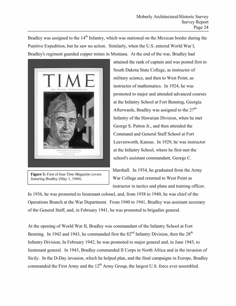
Figure 5: First of four Time Magazine covers featuring Bradley (May 1, 1944).
Bradley was assigned to the 14th Infantry, which was stationed on the Mexican border during the
Punitive Expedition, but he saw no action. Similarly, when the U.S. entered World War I,
Bradley's regiment guarded copper mines in Montana. At the end of the war, Bradley had
attained the rank of captain and was posted first to
South Dakota State College, as instructor of
military science, and then to West Point, as
instructor of mathematics. In 1924, he was
promoted to major and attended advanced courses
at the Infantry School at Fort Benning, Georgia.
Afterwards, Bradley was assigned to the 27th
Infantry of the Hawaiian Division, when he met
George S. Patton Jr., and then attended the
Command and General Staff School at Fort
Leavenworth, Kansas. In 1929, he was instructor
at the Infantry School, where he first met the
school's assistant commandant, George C.
Marshall. In 1934, he graduated from the Army
War College and returned to West Point as
instructor in tactics and plans and training officer.
In 1936, he was promoted to lieutenant colonel, and, from 1938 to 1940, he was chief of the
Operations Branch at the War Department. From 1940 to 1941, Bradley was assistant secretary
of the General Staff, and, in February 1941, he was promoted to brigadier general.
At the opening of World War II, Bradley was commandant of the Infantry School at Fort
Benning. In 1942 and 1943, he commanded first the 82nd Infantry Division, then the 28th
Infantry Division; In February 1942, he was promoted to major general and, in June 1943, to
lieutenant general. In 1943, Bradley commanded II Corps in North Africa and in the invasion of
Sicily. In the D-Day invasion, which he helped plan, and the final campaigns in Europe, Bradley
commanded the First Army and the 12th Army Group, the largest U.S. force ever assembled.
Moberly Architectural/Historic Survey Survey Report
Page 25
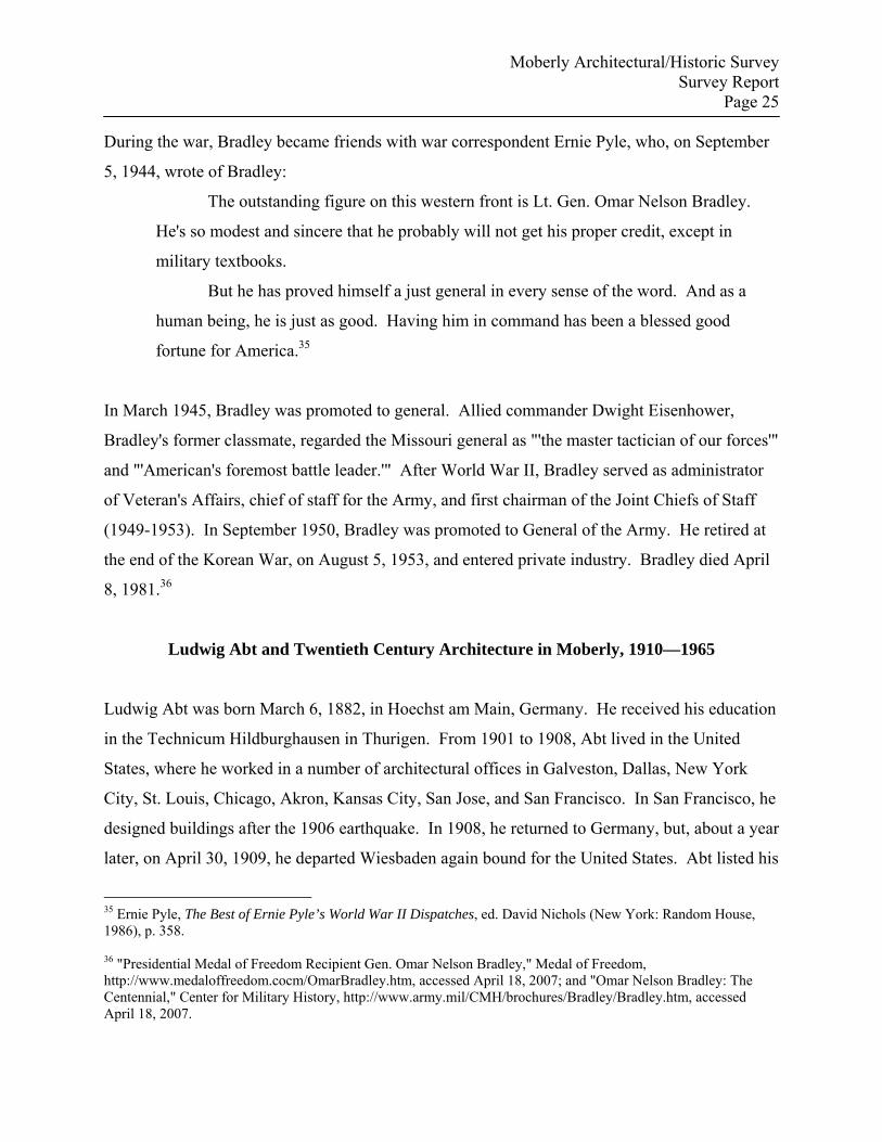
During the war, Bradley became friends with war correspondent Ernie Pyle, who, on September
5, 1944, wrote of Bradley:
The outstanding figure on this western front is Lt. Gen. Omar Nelson Bradley.
He's so modest and sincere that he probably will not get his proper credit, except in
military textbooks.
But he has proved himself a just general in every sense of the word. And as a
human being, he is just as good. Having him in command has been a blessed good
fortune for America.35
In March 1945, Bradley was promoted to general. Allied commander Dwight Eisenhower,
Bradley's former classmate, regarded the Missouri general as "'the master tactician of our forces'"
and "'American's foremost battle leader.'" After World War II, Bradley served as administrator
of Veteran's Affairs, chief of staff for the Army, and first chairman of the Joint Chiefs of Staff
(1949-1953). In September 1950, Bradley was promoted to General of the Army. He retired at
the end of the Korean War, on August 5, 1953, and entered private industry. Bradley died April
8, 1981.36
Ludwig Abt and Twentieth Century Architecture in Moberly, 1910—1965
Ludwig Abt was born March 6, 1882, in Hoechst am Main, Germany. He received his education
in the Technicum Hildburghausen in Thurigen. From 1901 to 1908, Abt lived in the United
States, where he worked in a number of architectural offices in Galveston, Dallas, New York
City, St. Louis, Chicago, Akron, Kansas City, San Jose, and San Francisco. In San Francisco, he
designed buildings after the 1906 earthquake. In 1908, he returned to Germany, but, about a year
later, on April 30, 1909, he departed Wiesbaden again bound for the United States. Abt listed his
35 Ernie Pyle, The Best of Ernie Pyle’s World War II Dispatches, ed. David Nichols (New York: Random House, 1986), p. 358. 36 "Presidential Medal of Freedom Recipient Gen. Omar Nelson Bradley," Medal of Freedom, http://www.medaloffreedom.cocm/OmarBradley.htm, accessed April 18, 2007; and "Omar Nelson Bradley: The Centennial," Center for Military History, http://www.army.mil/CMH/brochures/Bradley/Bradley.htm, accessed April 18, 2007.
Moberly Architectural/Historic Survey Survey Report
Page 26
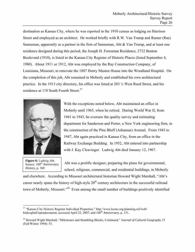
Figure 6: Ludwig Abt. Source: 100th Anniversary History, p. 360
destination as Kansas City, where he was reported in the 1910 census as lodging on Harrison
Street and employed as an architect. He worked briefly with R.W. Van Trump and Ramer (Rae)
Sanneman, apparently as a partner in the firm of Sanneman, Abt & Van Trump, and at least one
residence designed during this period, the Joseph H. Foresman Residence, 2732 Benton
Boulevard (1910), is listed in the Kansas City Register of Historic Places (listed September 4,
1980). About 1911 or 1912, Abt was employed by the Ray Construction Company, of
Louisiana, Missouri, to renovate the 1887 Henry Masten House into the Woodland Hospital. On
the completion of this job, Abt remained in Moberly and established his own architectural
practice. In the 1913 city directory, his office was listed at 203 ½ West Reed Street, and his
residence at 118 South Fourth Street.37
With the exceptions noted below, Abt maintained an office in
Moberly until 1965, when he retired. During World War II, from
1941 to 1943, he oversaw the quality survey and estimating
department for Sanderson and Porter, a New York engineering firm, in
the construction of the Pine Bluff (Arkansas) Arsenal. From 1943 to
1947, Abt again practiced in Kansas City, from an office in the
Railway Exchange Building. In 1952, Abt entered into partnership
with J. Kay Cleavinger. Ludwig Abt died January 12, 1967.
Abt was a prolific designer, preparing the plans for governmental,
school, religious, commercial, and residential buildings, in Moberly
and elsewhere. According to Missouri architectural historian Howard Wight Marshall, “Abt’s
career nearly spans the history of high-style 20th century architecture in the successful railroad
town of Moberly, Missouri.”38 Even among the small number of buildings positively identified
37 “Kansas City Historic Register Individual Properties,” http://www.kcmo.org/planning.nsf/web/ hiskcrgInd?opendocument, accessed April 22, 2007; and 100th Anniversary, p. 151. 38 Howard Wight Marshall, “Milestones and Stumbling Blocks, Continued,” Journal of Cultural Geography 15 (Fall/Winter 1994): 53.
Moberly Architectural/Historic Survey Survey Report
Page 27
as his work, his command of changing architectural styles and tastes is evident, ranging from the
various Revival styles to Art Deco and Moderne to post-war functionalism.
The Western Historical Manuscripts Collection (WHMC) at the University of Missouri—
Columbia retains a collection of Abt’s drawings and specifications, as well as photographs of a
number of his projects. However, the collection remains unprocessed, and it is difficult to
determine whether or not the projects represented were ever completed, and, in some cases, if
Abt did the drawings included in the collection. For example, plans for a number of courthouses,
such as Cooper County, Linn County, and Shannon County, are part of the collection, but Abt
did not design any of the three courthouses. (The Linn County Courthouse was designed by
Abt’s Kansas City associates, Sanneman and Van Trump.)
Other projects represented in the collection, such as the Macon Public Library and the Mary
Immaculate Church in Kirksville (1946-1947), were clearly his work. In Moberly, some of his
more prominent creations included the Municipal Auditorium (form #18); the Fourth Street
Theatre (form #62), which, according to Marshall displayed “San Simeon-like grandeur;”
Moberly Junior College (1930); and a number of “the brick public grade schools that embodied
the town’s progressive spirit,”including the Central School gymnasium/auditorium (1917),
Southeast Park School (1918), East Park School (1930), West Park School (1929), the Junior
High School (1930) and the Bradley school (remodeled Lincoln School, 1956), and, with
Cleavinger, the National Guard Armory, the Federal Building, and the Moberly Public Housing
Authority.39 Abt designed at least one theater in another state, the Walton Theater (1915) in
Philadelphia (no longer extant).
The Moberly to which Abt relocated in the second decade of the twentieth century had already
experienced its most explosive population growth, and, in subsequent decades, its population
was mostly stable. Its numerical peak was reached in 1930, at 13,772, but, ten years later, it
declined to 12,920.
39 Ibid., p. 54.
Moberly Architectural/Historic Survey Survey Report
Page 28
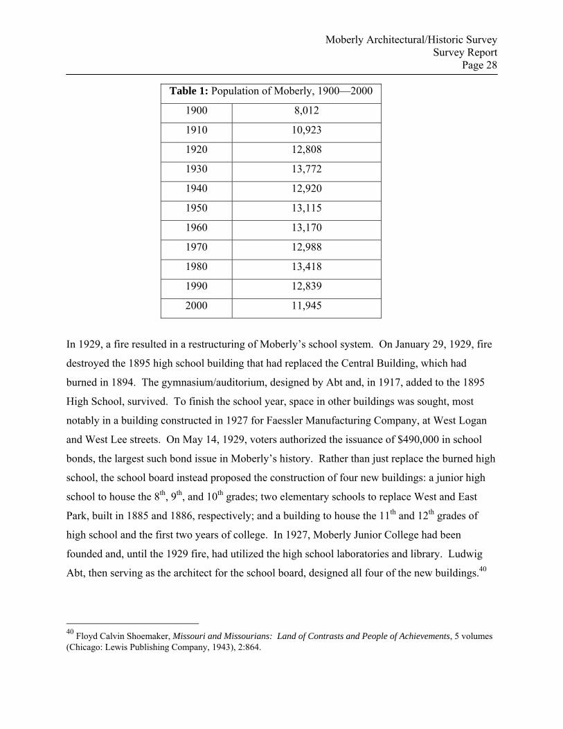
Table 1: Population of Moberly, 1900—2000
1900 8,012
1910 10,923
1920 12,808
1930 13,772
1940 12,920
1950 13,115
1960 13,170
1970 12,988
1980 13,418
1990 12,839
2000 11,945
In 1929, a fire resulted in a restructuring of Moberly’s school system. On January 29, 1929, fire
destroyed the 1895 high school building that had replaced the Central Building, which had
burned in 1894. The gymnasium/auditorium, designed by Abt and, in 1917, added to the 1895
High School, survived. To finish the school year, space in other buildings was sought, most
notably in a building constructed in 1927 for Faessler Manufacturing Company, at West Logan
and West Lee streets. On May 14, 1929, voters authorized the issuance of $490,000 in school
bonds, the largest such bond issue in Moberly’s history. Rather than just replace the burned high
school, the school board instead proposed the construction of four new buildings: a junior high
school to house the 8th, 9th, and 10th grades; two elementary schools to replace West and East
Park, built in 1885 and 1886, respectively; and a building to house the 11th and 12th grades of
high school and the first two years of college. In 1927, Moberly Junior College had been
founded and, until the 1929 fire, had utilized the high school laboratories and library. Ludwig
Abt, then serving as the architect for the school board, designed all four of the new buildings.40
40 Floyd Calvin Shoemaker, Missouri and Missourians: Land of Contrasts and People of Achievements, 5 volumes (Chicago: Lewis Publishing Company, 1943), 2:864.
Moberly Architectural/Historic Survey Survey Report
Page 29
In the 1930s, the importance of coal to Moberly and Randolph County, which had been equal in
value to agriculture in their economies, declined significantly. This was one more blow to an
economy already damaged by the farm crisis of the 1920s. The federal relief and recovery
programs instituted under President Franklin D. Roosevelt’s New Deal had an essential impact
on Moberly, as well as all of Missouri, during the Great Depression. Although the state
administration did not implement programs comparable to Roosevelt's New Deal, it did
cooperate with the national administration, much as it had welcomed federal involvement and
funding for the construction of highways in the previous decade. New Deal agencies provided
relief and jobs for the state's unemployed and new or improved facilities for many communities.
Through the New Deal programs, the federal government also became intimately involved in the
regulation or oversight of many areas previously reserved to state or local governments or that
had been unregulated.41
In 1933, a Civilian Conservation Corps camp was established south of Moberly, and it remained
in operation until 1939. A Rothwell Park beautification project and work on the 8-mile road
district were among the first Works Progress Administration (WPA) undertakings, and additional
New Deal activities included a business census, a rural housing survey, and sanitation work. On
September 28, 1938, Moberly voters approved an $88,000 bond issue for the construction of a
municipal auditorium. Total cost of the project was $160,000, with the federal Public Works
Administration (PWA) agreeing to pay 45% of the project cost, or $92,000. Local architect
Ludwig Abt designed the building, designated PWA Project #MO-1406-F. The completed
building was accepted by the city on November 18, 1940. At the dedication of the new facility, a
speech by Governor Lloyd Stark was followed by music provided by Ozzie Nelson and his band.
The first major performance in the auditorium occurred even before the formal dedication. On
October 10, 1940, violinist David Rubinoff appeared in a show arranged by the Moberly
Business and Professional Women. The auditorium hosted a variety of performances and
functions during its history, including City Council meetings, concerts, and high school and local
41 William E. Parrish, gen. ed., A History of Missouri, volume 5: 1919 to 1953, by Richard S. Kirkendall, Missouri Sesquicentennial Edition (Columbia, MO: University of Missouri Press, 1986), pp. 162-166.
Moberly Architectural/Historic Survey Survey Report
Page 30
college graduations. It also served as the armory for a National Guard company organized in the
auditorium.
On October 7, 1940, at a special election, the issue of $25,000 in bonds was approved to provide
the local share for a WPA project to construct a municipal airport. In 1938, a Moberly Airport
Association had been formed and had leased forty acres of land for an airfield. Because the
project was considered important in national defense, additional federal monies were made
available for the construction, which totaled approximately $500,000. On May 24, 1943, the city
council adopted a resolution naming the airport the Omar N. Bradley Airport. In 1940, the WPA
guide to Missouri offered a cursory inventory of Moberly’s industrial accomplishments:
. . . the shops of the Wabash Railroad, a large shoe factory, a hosiery mill, a hay-
press factory, and other manufacturing plants. Six coal mines are near by. The
town is a division point of the Wabash Railroad; trains enter its Union Station
from five directions.42
The hosiery mill—HRH Hosiery Mill—had been in operation in Moberly since 1927, and it was
one of an increasingly diversified list of employers for the still primarily railroad town.
Additional industries, many lured to town by the Moberly Development Corporation, included
the Bersted Manufacturing Company, a division of McGraw-Edison Company, which employed
about 350 employees at its peak; the Singer Sewing Machine Company, which operated a
warehouse west of Moberly; the Orscheln Brake Lever Company, which expanded its plant in
1957; and Uregas, which opened a warehouse and district plant office in 1958. In 1959, the
Madison-Faessler Tool Company, a Moberly institution since 1883, moved its operations to
Providence, Rhode Island.43
42 Workers of the Writers’ Program of the Works Project Administration in the State of Missouri, The WPA Guide to 1930s Missouri [originally published as Missouri: A Guide to the “Show Me” State], foreword by Charles van Ravenswaay and introduction by Howard Wight Marshall and Walter A. Schroeder (New York: Duell, Sloan and Pearce, 1941; reprint ed., Lawrence: University Press of Kansas, 1986), p. 370 and 464. Hereafter cited as WPA Guide to 1930s Missouri. 43 See 100th Anniversary History, chapters on History and Industrial and Commercial. HRH Hosiery closed in 1954. A Pictorial History of Moberly, Missouri, p. 74.
Moberly Architectural/Historic Survey Survey Report
Page 31
III. Methodology
The City of Moberly and the Historic Preservation Commission's Historic Preservation Fund
(HPF) grant application for a historic buildings survey specified survey boundaries (see
Geographical Description) and a list of potential survey properties. One purpose of the survey
was to identify properties that may meet the National Register Criteria for Evaluation, either
individually or as contributing buildings within one or more historic districts. Within the
selected geographical boundaries, the properties listed in the grant application were evaluated,
and those that displayed the highest level of integrity and that represented those historic themes
most important to the development of Moberly were photographed and information about them
recorded on inventory forms.
However, initial assessments within the survey boundaries, guided by the preliminary list of
properties provided in the grant application, yielded nearly one hundred historic properties, well
above the sixty-nine properties specified in the grant contract. In consultation with the Historic
Preservation Commission and the City Manager, photographs of all properties fifty years old and
older and within the original survey boundaries, were reviewed, and it was mutually agreed that
residential properties, with three exceptions, all associated with General Omar N. Bradley, would
not be included in the revised survey. However, an additional Bradley related property was
subsequently identified and was also included in the survey (see forms #76, #77, #78, and #79).
Additionally, it was decided that the focus of the survey would be commercial buildings,
specifically contiguous commercial buildings that might be likely to yield one or more potential
historic districts. As a result, all churches, with the exception of two historic African-American
churches on the northern edge of the survey area, were eliminated from the list of surveyed
properties. As the survey advanced, research identified some buildings that had previously
unsuspected historic significance and that had originally been excluded because of issues of
integrity; these buildings were also included in the final survey total. Several commercial
buildings, primarily on the north side of West Coates and south of West Rollins, were excluded
because they were separated from the core commercial area by altered buildings, vacant lots, or
Moberly Architectural/Historic Survey Survey Report
Page 32
recent, non-historic construction. One school building, regarded as endangered, was added to the
list of surveyed properties late in the process. Despite the exclusions noted above, the final count
of surveyed buildings expanded to eighty-two, a nearly 16 percent increase over the original
sixty-nine properties specified in the original grant application.
Each primary resource was photographed. Because the majority of the buildings surveyed were
commercial in function, only one secondary resource was surveyed. In addition, streets that
included a number of non-contributing, unsurveyed resources were also photographed in
streetscapes. At the same time the resources were photographed, notes were recorded on the
physical attributes of the properties, including addresses where apparent; distinctive architectural
features or details; alterations or additions; estimated date of construction; and the physical
setting of the property. Information on altered, non-contributing properties was also noted, and a
rough sketch of each block was made.
Published resources on the history of Moberly are plentiful. Beginning in 1884, Randolph
County was included with Macon County in a volume published by the National Historical
Company. In 1896, in the Moberly Art Souvenir, a local printer provided an assessment of the
town’s first thirty years of progress; Moberly, Missouri: The Magic City, also titled Moberly
1909, provided a comprehensive overview of the commercial and industrial status of the town at
a pivotal point in its history; and on the fiftieth anniversary, Moberly Fifty Years Ago—and To-
Day offered a similar, optimistic overview. Among the more recent histories, the hundredth
anniversary was marked by a large retrospective compiled by the Moberly Centennial
Association. Former Moberly Area Community College professor Ralph Gerhard, through the
auspices of the Randolph County Historical Society, has published three volumes of a minutely
detailed history of the early years of Moberly, as well as Madams, Painted Ladies and Johns: A
Newspaper History of Prostitution in Moberly, Missouri, 1866-1966. In addition, the Randolph
County Historical Society maintains a museum and research library, including an extensive
collection of city directories. Historic commission and historical society members also
volunteered to research historic use of surveyed buildings and provided a wealth of useful
information.
Moberly Architectural/Historic Survey Survey Report
Page 33
IV. Results and Recommendations
Initial reconnaissance of the original survey area identified a number of potential individually
eligible properties, and these preliminary surveys also strongly suggested the likelihood of one or
more potential commercial historic districts. Despite an initial false start, Moberly prospered
from its founding and quickly tied its fortunes to the success of its railroads. Growth was
spectacular at first, due largely to Moberly’s position as a rail junction, which gave added status
to its other roles as a regional trade center, a center for the distribution of agricultural products,
and a minor industrial center. Following the explosion of population and commerce that gave
the city the title “The Magic City,” subsequent growth was slower and more stable. This
stability was reflected by a number of long-term businesses, some with tenure of a half-century
or more. Although historic photographs, Sanborn Fire Insurance Company maps, and visual
evidence indicates the loss or alteration of an unfortunate number of historic resources, even as
recently as the last few years—the 1889 Union Depot was probably the most substantial loss—
Moberly retained an enviable number of buildings and structures representing the local and
national historic trends and themes that shaped the city’s history.
In the revised list of eighty-two surveyed properties, three property types and a number of sub-
types were identified:
Commercial Buildings
Institutional Buildings
Governmental Buildings
Religious Buildings
• African-American Religious Buildings
Fraternal Buildings
School Buildings
Residential Buildings
Buildings associated with Omar N. Bradley
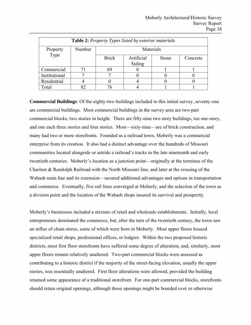
Moberly Architectural/Historic Survey Survey Report
Page 34
Table 2: Property Types listed by exterior materials
Materials Property Type
Number
Brick Artificial Siding
Stone Concrete
Commercial 71 69 0 1 1 Institutional 7 7 0 0 0 Residential 4 0 4 0 0 Total 82 76 4 1 1
Commercial Buildings: Of the eighty-two buildings included in this initial survey, seventy-one
are commercial buildings. Most commercial buildings in the survey area are two-part
commercial blocks, two stories in height. There are fifty-nine two story buildings, ten one-story,
and one each three stories and four stories. Most—sixty-nine—are of brick construction, and
many had two or more storefronts. Founded as a railroad town, Moberly was a commercial
enterprise from its creation. It also had a distinct advantage over the hundreds of Missouri
communities located alongside or astride a railroad’s tracks in the late nineteenth and early
twentieth centuries. Moberly’s location as a junction point—originally at the terminus of the
Chariton & Randolph Railroad with the North Missouri line, and later at the crossing of the
Wabash main line and its extension—secured additional advantages and options in transportation
and commerce. Eventually, five rail lines converged at Moberly, and the selection of the town as
a division point and the location of the Wabash shops insured its survival and prosperity.
Moberly’s businesses included a mixture of retail and wholesale establishments. Initially, local
entrepreneurs dominated the commerce, but, after the turn of the twentieth century, the town saw
an influx of chain stores, some of which were born in Moberly. Most upper floors housed
specialized retail shops, professional offices, or lodgers. Within the two proposed historic
districts, most first floor storefronts have suffered some degree of alteration, and, similarly, most
upper floors remain relatively unaltered. Two-part commercial blocks were assessed as
contributing to a historic district if the majority of the street-facing elevation, usually the upper
stories, was essentially unaltered. First floor alterations were allowed, provided the building
retained some appearance of a traditional storefront. For one-part commercial blocks, storefronts
should retain original openings, although those openings might be boarded over or otherwise
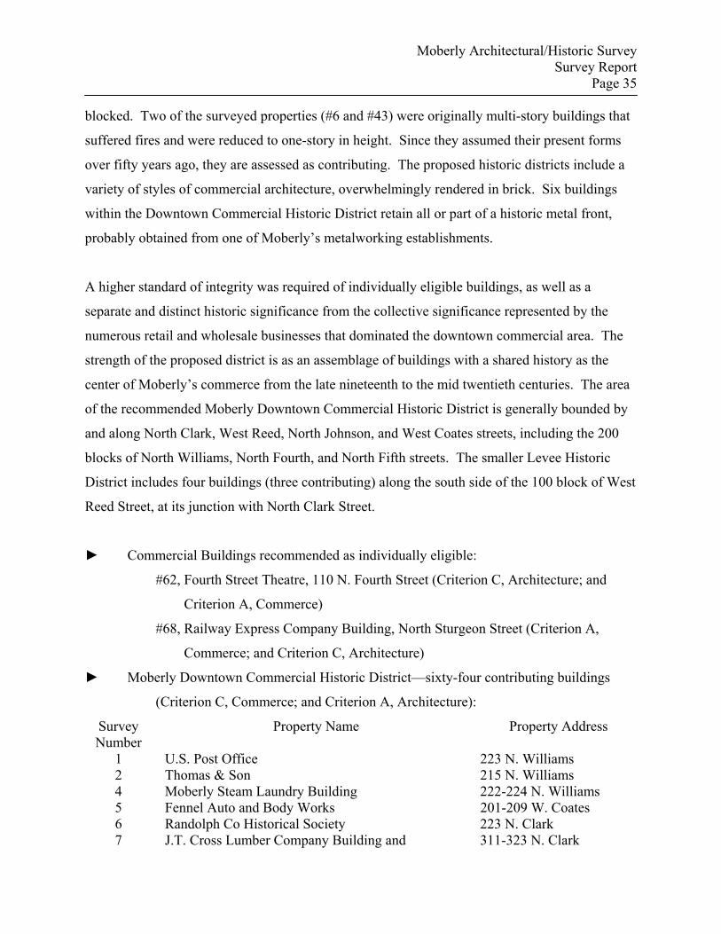
Moberly Architectural/Historic Survey Survey Report
Page 35
blocked. Two of the surveyed properties (#6 and #43) were originally multi-story buildings that
suffered fires and were reduced to one-story in height. Since they assumed their present forms
over fifty years ago, they are assessed as contributing. The proposed historic districts include a
variety of styles of commercial architecture, overwhelmingly rendered in brick. Six buildings
within the Downtown Commercial Historic District retain all or part of a historic metal front,
probably obtained from one of Moberly’s metalworking establishments.
A higher standard of integrity was required of individually eligible buildings, as well as a
separate and distinct historic significance from the collective significance represented by the
numerous retail and wholesale businesses that dominated the downtown commercial area. The
strength of the proposed district is as an assemblage of buildings with a shared history as the
center of Moberly’s commerce from the late nineteenth to the mid twentieth centuries. The area
of the recommended Moberly Downtown Commercial Historic District is generally bounded by
and along North Clark, West Reed, North Johnson, and West Coates streets, including the 200
blocks of North Williams, North Fourth, and North Fifth streets. The smaller Levee Historic
District includes four buildings (three contributing) along the south side of the 100 block of West
Reed Street, at its junction with North Clark Street.
► Commercial Buildings recommended as individually eligible:
#62, Fourth Street Theatre, 110 N. Fourth Street (Criterion C, Architecture; and
Criterion A, Commerce)
#68, Railway Express Company Building, North Sturgeon Street (Criterion A,
Commerce; and Criterion C, Architecture)
► Moberly Downtown Commercial Historic District—sixty-four contributing buildings
(Criterion C, Commerce; and Criterion A, Architecture):
Survey Number
Property Name Property Address
1 U.S. Post Office 223 N. Williams 2 Thomas & Son 215 N. Williams 4 Moberly Steam Laundry Building 222-224 N. Williams 5 Fennel Auto and Body Works 201-209 W. Coates 6 Randolph Co Historical Society 223 N. Clark 7 J.T. Cross Lumber Company Building and 311-323 N. Clark
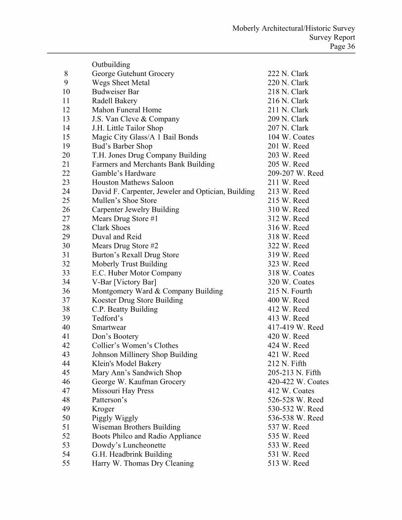
Moberly Architectural/Historic Survey Survey Report
Page 36
Outbuilding 8 George Gutehunt Grocery 222 N. Clark 9 Wegs Sheet Metal 220 N. Clark 10 Budweiser Bar 218 N. Clark 11 Radell Bakery 216 N. Clark 12 Mahon Funeral Home 211 N. Clark 13 J.S. Van Cleve & Company 209 N. Clark 14 J.H. Little Tailor Shop 207 N. Clark 15 Magic City Glass/A 1 Bail Bonds 104 W. Coates 19 Bud’s Barber Shop 201 W. Reed 20 T.H. Jones Drug Company Building 203 W. Reed 21 Farmers and Merchants Bank Building 205 W. Reed 22 Gamble’s Hardware 209-207 W. Reed 23 Houston Mathews Saloon 211 W. Reed 24 David F. Carpenter, Jeweler and Optician, Building 213 W. Reed 25 Mullen’s Shoe Store 215 W. Reed 26 Carpenter Jewelry Building 310 W. Reed 27 Mears Drug Store #1 312 W. Reed 28 Clark Shoes 316 W. Reed 29 Duval and Reid 318 W. Reed 30 Mears Drug Store #2 322 W. Reed 31 Burton’s Rexall Drug Store 319 W. Reed 32 Moberly Trust Building 323 W. Reed 33 E.C. Huber Motor Company 318 W. Coates 34 V-Bar [Victory Bar] 320 W. Coates 36 Montgomery Ward & Company Building 215 N. Fourth 37 Koester Drug Store Building 400 W. Reed 38 C.P. Beatty Building 412 W. Reed 39 Tedford’s 413 W. Reed 40 Smartwear 417-419 W. Reed 41 Don’s Bootery 420 W. Reed 42 Collier’s Women’s Clothes 424 W. Reed 43 Johnson Millinery Shop Building 421 W. Reed 44 Klein's Model Bakery 212 N. Fifth 45 Mary Ann’s Sandwich Shop 205-213 N. Fifth 46 George W. Kaufman Grocery 420-422 W. Coates 47 Missouri Hay Press 412 W. Coates 48 Patterson’s 526-528 W. Reed 49 Kroger 530-532 W. Reed 50 Piggly Wiggly 536-538 W. Reed 51 Wiseman Brothers Building 537 W. Reed 52 Boots Philco and Radio Appliance 535 W. Reed 53 Dowdy’s Luncheonette 533 W. Reed 54 G.H. Headbrink Building 531 W. Reed 55 Harry W. Thomas Dry Cleaning 513 W. Reed
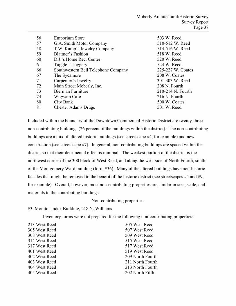
Moberly Architectural/Historic Survey Survey Report
Page 37
56 Emporium Store 503 W. Reed 57 G.A. Smith Motor Company 510-512 W. Reed 58 T.W. Kamp’s Jewelry Company 514-516 W. Reed 59 Blattner’s Fashion 518 W. Reed 60 D.J.’s Home Rec. Center 520 W. Reed 61 Tuggle’s Toggery 524 W. Reed 66 Southwestern Bell Telephone Company 225-227 W. Coates 67 The Sycamore 208 W. Coates 71 Carpenter’s Jewelry 301-303 W. Reed 72 Main Street Moberly, Inc. 208 N. Fourth 73 Bierman Furniture 210-214 N. Fourth 74 Wigwam Cafe 216 N. Fourth 80 City Bank 500 W. Coates 81 Chester Adams Drugs 501 W. Reed
Included within the boundary of the Downtown Commercial Historic District are twenty-three
non-contributing buildings (26 percent of the buildings within the district). The non-contributing
buildings are a mix of altered historic buildings (see streetscape #4, for example) and new
construction (see streetscape #7). In general, non-contributing buildings are spaced within the
district so that their detrimental effect is minimal. The weakest portion of the district is the
northwest corner of the 300 block of West Reed, and along the west side of North Fourth, south
of the Montgomery Ward building (form #36). Many of the altered buildings have non-historic
facades that might be removed to the benefit of the historic district (see streetscapes #4 and #9,
for example). Overall, however, most non-contributing properties are similar in size, scale, and
materials to the contributing buildings.
Non-contributing properties:
#3, Monitor Index Building, 218 N. Williams
Inventory forms were not prepared for the following non-contributing properties:
213 West Reed 305 West Reed 308 West Reed 314 West Reed 317 West Reed 401 West Reed 402 West Reed 403 West Reed 404 West Reed 405 West Reed
505 West Reed 507 West Reed 509 West Reed 515 West Reed 517 West Reed 519 West Reed 209 North Fourth 211 North Fourth 213 North Fourth 202 North Fifth
Moberly Architectural/Historic Survey Survey Report
Page 38
210 North Fifth 213 North Williams
► The Levee Historic District—three contributing buildings (Criterion A, Commerce; and
Criterion C, architecture)
The Levee Historic District consists of three contributing buildings—118, 120, and 124 West
Reed Street—and one non-contributing building—124 West Reed Street. Moberly’s Levee was
originally the west side of North Sturgeon Street between Reed and Rollins. An area where
many types of vice were usually tolerated by local authorities, the area was probably named after
Chicago’s south side Levee, which spawned such criminals as Al Capone. A river levee was
also a jumping off place for travelers, and Moberly’s Levee was adjacent to the Union Station,
where most train passengers disembarked. The Levee was also the first view many of those
passengers had of the town. In the twentieth century, the Levee moved around the corner from
Sturgeon Street to West Reed Street and part of the 200 block of North Clark. Neglect and a
series of disastrous fires accomplished what local authorities were unable or unwilling to do, and
only four buildings remain to represent the area.44
The three contributing buildings served a variety of businesses, as did most Moberly commercial
buildings. Both 118 and 124 West Reed served at least briefly as saloons. A firm date of
construction was not determined for any of the buildings, but all four buildings appeared to
match the footprint on the 1884 Sanborn map, the earliest available for Moberly. The facade, or
north elevation, of 118 West Reed was faced with a darker harder brick; the exposed east
elevation retains what appear to be older, softer brick. All the buildings may have been similarly
renovated.
Survey Number
Property Name Property Address
16 Star Billiard Hall 124 West Reed 17 Tony’s 118 West Reed 65 National Dairy Lunch 120 West Reed
44 Gerhard, Madams, Painted Ladies and Johns, pp. 53-61.
Moberly Architectural/Historic Survey Survey Report
Page 39
Non-contributing property:
122 West Reed Street (inventory form not prepared)—in 1884, the building at this location
housed a barber, Masonic lodge, and lodging: in 1888, it was used as a barber and a shoe shop.
In 1893, a fruit and news business occupied the location, and, in 1899, it was again a barber. In
1909, it was a drug store.
Institutional Buildings: Only seven of the eighty-two buildings surveyed were institutional
buildings. They were further classified as: governmental buildings (3); religious buildings (2);
school buildings (1); and fraternal buildings (1). The three governmental buildings were the U.S.
Post Office (#1), the Municipal Auditorium (#18), and the Carnegie Public Library (#63). Each
building is architecturally significant, and each represents different aspects of government
authority or responsibility.
In 1905-1906, the U.S. Post Office, 223 North Williams Street, was constructed, under the tenure
of James Knox Taylor as Supervising Architect of the Treasury (1897-1912). Taylor believed
government buildings should be both attractive and monumental, the tangible representations of
democratic ideals. He, therefore, emphasized designs derived from classical ideals or early
American examples. Taylor also insisted on permanence and emphasized high quality
construction materials. Private or government architects individually designed all buildings, and
Taylor rejected the use of standardized designs.45 The post office served Moberly until 1961.
On September 28, 1938, Moberly voters approved an $88,000 bond issue for the construction of
a municipal auditorium (#18). Total cost of the project was $160,000, with the federal Public
Works Administration (PWA) agreeing to pay 45% of the project cost, or $92,000. Local
architect Ludwig Abt designed the building, designated PWA Project #MO-1406-F, in a
restrained and effective interpretation of the Art Moderne style. The completed building was
accepted by the city on November 18, 1940. Since its completion, the auditorium has hosted a
45 Beth Boland, How to Apply the National Register Criteria to Post Offices, National Register Bulletin #13, Part II. Historical and Architectural Development of Postal Services and Post Office Construction, revised edition, 1994, http://www.cr.nps.gov/nr/publications/bulletins/nrb13/part2.htm, accessed April 20, 2007.
Moberly Architectural/Historic Survey Survey Report
Page 40
variety of performances and functions, including City Council meetings, concerts, and high
school and local college graduations; it also served as an armory during the 1950s.
After a series of unsuccessful attempts by several groups to establish a public library, Moberly
Mayor Willard P. Cave wrote Andrew Carnegie in January 1902 to request a grant to construct a
library building. Three months later, Carnegie’s staff responded with the counterproposal that, if
the City Council would pledge by resolution to support a free public library in the amount of not
less that $1,500 a year and provide a suitable location, Carnegie would contribute $15,000
towards a building. The amount of city support was later raised to $2,000 a year, and Carnegie's
donation increased to $20,000. Constructed in a characteristically overstated Classical style, the
Carnegie Library (#63) has been joined to a more modern building as part of the Little Dixie
Regional Library, but its architectural details and design have been preserved, and it retains the
ability to convey its significance in the area of Social History.
Of the two religious buildings included in the survey, both are representatives of the subtype
African-American religious buildings. The Second Baptist Church (#69), 314 N. Fifth Street,
and Grant Chapel AME (#70), 411 North Fifth Street, are located north of the early commercial
area of Moberly. Both churches were established within three years of each other, shortly after
the Civil War as part of a general movement for separation favored by African-Americans after
emancipation, a segregation enforced first by custom, and then by law. A separate church
permitted a degree of independence and self-determination not permissible in an integrated body
and represented for many African-Americans a natural extension of their freedom. In May 1867,
the Second Baptist Church began in Allen. It was organized by the Reverend Thomas Clark and
originally met in a blacksmith shop. In 1871, the church was relocated to Moberly, where the
congregation met at several different locations before construction on a new building was begun
in 1900, under Reverend W.H. Hill. In 1918, the building burned. Construction of the present
building began in 1920, under the leadership of Reverend Charles Johnson. In 1870, Grant
Chapel AME Church was organized in the home of Mrs. Lucile Thomas, at 215 South Clark
Street, by the Reverend Madison Corbin, of Macon. The original congregation consisted of only
two members. The church’s second location was on Fourth Street, then Fifth and Coates. In
Moberly Architectural/Historic Survey Survey Report
Page 41
1913, under the tenure of the Reverend F.D. Wells, it moved to the present building, at North
Fifth and Winchester. Before and after the Civil War, black preachers provided social leadership
for their communities. Both buildings represent the transcendent role the church and its minister
played in the African-American community. The preacher provided social leadership for his
community, and the church also served beyond its religious purposes as a community center.
Usually located in the heart of the community, the building was typically used for community
meetings and for recreational and social activities and provided some measure of security from
intrusion.
One institutional building is a school, the circa 1930 junior high school, with its 1917
gymnasium/auditorium (#82). This building is located on the site of the 1895 Moberly High
School, which replaced the 1876 building that had burned in 1894. In 1917, an auditorium was
added to the rear (west elevation). On January 29, 1929, a fire destroyed the 1895 high school,
but the auditorium was saved. To finish the school year, space in other buildings was sought,
most notably in a building constructed in 1927 for Faessler Manufacturing Company, at West
Logan and West Lee streets. On May 14, 1929, an election was held to authorize the issue of
$490,000 in school bonds, the largest such bond issue in Moberly’s history. The school board
proposed to construct four new buildings: a building to house the 11th and 12th grades of high
school and the first two years of college; a junior high school to house the 8th, 9th, and 10th
grades; and two elementary schools to replace West and East Park schools, built in 1885-1886.
Ludwig Abt, who served as architect for the school board, designed all four of the new buildings.
In the fall of 1930, the junior high school building was completed. This first year, the building
housed all four high school grades and the two-year junior college classes.
Constructed in 1929-1930 in a subdued Art Moderne style but touted as an “Egyptian Temple”
by the local newspaper, Moberly Lodge No. 344 AF&AM (#64) was designed by Victor J.
DeFoe.46 DeFoe was born in 1892 in Mexico; his father was Canadian and his mother a native
of Ohio. He began work as an architect for the American Sash, Door and Fixture Company in
Kansas City, and the majority of his designs were for residences. He also designed the Governor
46 “Egyptian Temple to Be Built for Moberly Masonry,” Moberly Monitor-Index, May 17, 1929, p. 1.
Moberly Architectural/Historic Survey Survey Report
Page 42
Henry Caulfield Horse Barn (1929), on the Missouri State Fairgrounds, and the Camden County
Courthouse (1931). A copy of DeFoe’s design for the lodge was included in the Ludwig Abt
papers.
► Institutional Buildings recommended as eligible:
#1, U.S. Post Office, 223 North Williams Street (Criterion C, architecture; and
Criterion A, Politics/Government; included within the boundaries of the
recommended historic district)
#18, Municipal Auditorium, 201 West Rollins (Criterion C, architecture; and
Criterion A, Politics/Government)
#63, Carnegie Public Library, 111 North Fourth Street (Criterion C, architecture;
and Criterion A, Social History)
#64, Moberly Lodge No. 344 AF&AM, 401 West Rollins Street (Criterion C,
architecture; and Criterion A, Social History)
#69, Second Baptist Church, 314 N. Fifth Street (Criterion C, architecture; and
Criterion A, Ethnic Heritage—Black)
#70, Grant Chapel AME, 411 North Fifth Street (Criterion C, architecture; and
Criterion A, Ethnic Heritage—Black)
#82, Moberly Junior High School, 101 North Johnson Street (Criterion C,
architecture; and Criterion A, Education)
Residential Buildings: In general, residential buildings were excluded from the survey, with the
exception of four buildings related to General of the Army Omar Nelson Bradley’s brief period
of residence in Moberly, from 1908 to 1911. Three of the houses (#76, #77, and #78) were
rented by Bradley’s mother; the fourth (#79) was the residence of the family of Charles and Dora
Quayle, the parents of Bradley’s first wife, Mary Elizabeth Quayle. The houses were all
similar—one-story, pyramidal roofs with lower cross gables, and vague Craftsman references—
of a type associated with working class housing in early twentieth century railroad towns. All
four have been altered by the introduction of artificial siding, and wrought iron replaced the
porch supports of one, the Quayle House (#79). Despite these alterations, all four houses have
Moberly Architectural/Historic Survey Survey Report
Page 43
strong associations with Bradley during a pivotal, formative point in his life, when he made the
decision to seek appointment to West Point.
► Residential Buildings associated with Omar N. Bradley recommended as eligible
(Criterion B, military):
#76, Omar N. Bradley House #1, 119 South Tannehill Street—this was the house
rented by Bessie and Omar Bradley on their arrival in Moberly after the death
of Omar’s father. The Bradleys are listed as residents in the 1909 city
directory.
#77, Omar N. Bradley House #2, 604 South Fourth Street—according to the 1910
census and city directory, this house was probably the second Moberly
residence rented by the Bradleys. Omar lived here when he graduated high
school and began working for the Wabash. It was also across the street from
the house where his future wife lived.
#78, Omar N. Bradley House #3, 1226 Myra Street—this was the last house in
which Omar lived before departing Moberly. It was also where he lived when
he took the entrance examinations for the U.S. military academy.
#79, Charles L. and Eudora Goodfellow Quayle House, 605 South Fourth Street—
this was the residence of Bradley’s future first wife, Mary Elizabeth Quayle,
daughter of Charles and Eudora, and was across the street from the house
where Bradley lived in 1910.
As noted above, Moberly has a wealth of historic resources. The one constant concern during
the course of the survey was to manage the number of resources so that it remained within the
parameters of the grant contract, an objective not entirely realized. Consequently, religious
buildings and residential buildings were all but eliminated from the final survey list (see Figures
7 and 8). In addition, commercial buildings not contiguous to the core commercial area bounded
by West Coates on the north and West Rollins on the south, and by the railroad on the east and
North Johnson on the west, were pared from the final count.
Moberly Architectural/Historic Survey Survey Report
Page 44
Preservation efforts in Moberly would undoubtedly profit from additional survey. The proposed
historic district includes only a portion of the buildings related to the commercial and industrial
history of the town. Similar properties remain unrecorded within the larger, original survey area,
and other commercial and industrial buildings are located outside the historic downtown. Most,
if not all, of the churches and residences included within the original survey proposal, and
excluded from the current project only because of time and cost considerations, are individually
eligible. Additional historic residences abound in Moberly, and a more thorough inventory
would likely yield additional individually eligible examples, as well as historic districts. A
comprehensive inventory of Moberly's historic resources would be a massive undertaking, but
thematic surveys, such as religious architecture, would provide a finite list of properties with
shared characteristics and context that could be listed with comparative ease.
For any community with a significant number and variety of historic resources, the most
effective, long-term strategy for listing those resources in the National Register of Historic
Places is the preparation of a Multiple Property Submission. Although a nomination for the
proposed downtown historic district would require the development of a thorough historic
context for the economic history and commercial architecture of Moberly, the application of a
district nomination to other property types would be limited. A multiple property cover
document, which details historic contexts and property types associated with a community,
would provide the framework for listing the full range of historic resources that might be
identified.

Moberly Architectural/Historic Survey Survey Report
Page 45
Two examples of buildings not surveyed:
Figure 7: First Baptist Church, 514 West Rollins Street
Figure 8: Coates Street Presbyterian Church, 601 West Coates Street
Moberly Architectural/Historic Survey Survey Report
Page 46
Selected Bibliography Atherton, Lewis. Main Street on the Middle Border. Bloomington: Indiana University Press,
1954. “Brown Shoe Company, Inc.” Funding Universe. Http://www.fundinguniverse.com/company-
histories/Brown-Shoe-Company-Inc-Company-History.html. Accessed December 10, 2006.
Cass County v. Gillett. 100 U.S. 585. Http://supreme.justia.com/us/100/585/case.html.
Accessed November 28, 2006. Edwards Brothers, comp. An Illustrated Historical Atlas of Randolph County, Missouri.
Philadelphia, PA: Edwards Brothers, 1876. Feurer, Rosemary, "Shoe City, Factory Towns: St. Louis Shoe Companies and the Turbulent
Drive for Cheap Rural Labor, 1900-1940," Gateway Heritage 9 (Fall 1988): 2-17. Gates, Paul W., "The Railroads of Missouri, 1850-1870," Missouri Historical Review 26
(October 1931): 126-141. Gerhard, Ralph E. The Early Day History of Moberly, Missouri, volume 2: 1868—1869—1870,
3 vols. Moberly, MO: Randolph County Historical Society, n.d.. _______________. Madams, Painted Ladies and Johns: A Newspaper History of Prostitution in
Moberly, Missouri, 1866-1966. Moberly, MO: Randolph County Historical Society, 2004.
Heimburger, Donald. Wabash. River Forest, IL: Heimburger House Publishing Company, 1984. History of Randolph and Macon Counties, Missouri. St. Louis: National Historical Company,
1884. Hudson, John C., "Towns of the Western Railroads," Great Plains Quarterly 2 (Winter 1982),
pp. 41-54. Lynch, John E., comp. Moberly Fifty Years Ago—and To-Day. Moberly, MO: Democrat, 1916;
reprint ed., Moberly: Randolph County Historical Society, n.d. Marshall, Howard Wight. “Milestones and Stumbling Blocks, Continued.” Journal of Cultural
Geography 15 (Fall/Winter 1994): 45-58.
Moberly Architectural/Historic Survey Survey Report
Page 47
Masterson, V.V. The Katy Railroad and the Last Frontier. With a new forward by Donovan L. Hofsommer. Norman: University of Oklahoma Press, 1942; reprint ed., Columbia: University of Missouri Press, 1988.
Moberly Art Souvenir. Moberly, MO: J.E. McQuitty, Book and Job Printer, 1896; reprint ed:
Moberly: Crown Press for Moberly Historical and Railroad Museum, n.d. Oster, Donald B., "The Hannibal and St. Joseph Railroad, Government and Town Founding,
1846-1861," Missouri Historical Review 87 (July 1993): 403-421. "Our History," Brown Shoe [website]. Http://www.brownshoe.com/history/index.asp. Accessed
December 13, 2006. Ray County v. Vansycle. 96 U.S. 675. Http://supreme.justia.com/us/96/675/case.html.
Accessed August 15, 2006. Rothwell, Will A., "Moberly," in Howard L. Conard, ed., Encyclopedia of the History of
Missouri. 6 vols. New York: Southern History Company, 1901. Shoemaker, Floyd Calvin Shoemaker. Missouri and Missourians: Land of Contrasts and
People of Achievements. 5 volumes. Chicago: Lewis Publishing Company, 1943. U.S. Department of Commerce. Census Office. Twelfth Census of the United States, Taken in
the Year 1900: Manufactures. Part 3, Special Reports on Selected Industries. _______________. Bureau of the Census. Thirteenth Census of the United States Taken in the
Year 1910. Volume 9, Manufactures, 1909: Reports by States, with Statistics for Principal Cities.
_______________. Census of Manufactures, 1914. Volume 1: Reports by States with Statistics
for Principal Cities and Metropolitan Districts. Waller, Alexander H. History of Randolph County, Missouri. Topeka, KS: Historical Publishing
Company, 1920. Williams, Walter, ed. The State of Missouri: An Autobiography. Columbia: Press of E.W.
Stephens, 1904.
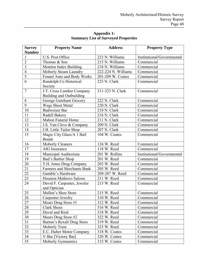
Moberly Architectural/Historic Survey Survey Report
Page 48
Appendix 1: Summary List of Surveyed Properties
Survey Number
Property Name Address Property Type
1 U.S. Post Office 223 N. Williams Institutional/Governmental2 Thomas & Son 215 N. Williams Commercial 3 Monitor Index Building 218 N. Williams Commercial 4 Moberly Steam Laundry 222-224 N. Williams Commercial 5 Fennel Auto and Body Works 201-209 W. Coates Commercial 6 Randolph Co Historical
Society 223 N. Clark Commercial
7 J.T. Cross Lumber Company Building and Outbuilding
311-323 N. Clark Commercial
8 George Gutehunt Grocery 222 N. Clark Commercial 9 Wegs Sheet Metal 220 N. Clark Commercial 10 Budweiser Bar 218 N. Clark Commercial 11 Radell Bakery 216 N. Clark Commercial 12 Mahon Funeral Home 211 N. Clark Commercial 13 J.S. Van Cleve & Company 209 N. Clark Commercial 14 J.H. Little Tailor Shop 207 N. Clark Commercial 15 Magic City Glass/A 1 Bail
Bonds 104 W. Coates Commercial
16 Moberly Cleaners 124 W. Reed Commercial 17 AIG Insurance 118 W. Reed Commercial 18 Municipal Auditorium 201 W. Rollins Institutional/Governmental19 Bud’s Barber Shop 201 W. Reed Commercial 20 T.H. Jones Drug Company 203 W. Reed Commercial 21 Farmers and Merchants Bank 205 W. Reed Commercial 22 Gamble’s Hardware 209-207 W. Reed Commercial 23 Houston Mathews Saloon 211 W. Reed Commercial 24 David F. Carpenter, Jeweler
and Optician 213 W. Reed Commercial
25 Mullen’s Shoe Store 215 W. Reed Commercial 26 Carpenter Jewelry 310 W. Reed Commercial 27 Mears Drug Store #1 312 W. Reed Commercial 28 Clark Shoes 316 W. Reed Commercial 29 Duval and Reid 318 W. Reed Commercial 30 Mears Drug Store #2 322 W. Reed Commercial 31 Burton’s Rexall Drug Store 319 W. Reed Commercial 32 Moberly Trust 323 W. Reed Commercial 33 E.C. Huber Motor Company 318 W. Coates Commercial 34 V-Bar [Victory Bar] 320 W. Coates Commercial 35 Moberly Gymnastics 315 W. Coates Commercial
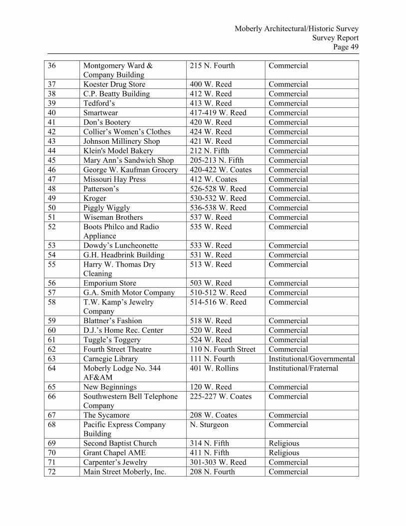
Moberly Architectural/Historic Survey Survey Report
Page 49
36 Montgomery Ward & Company Building
215 N. Fourth Commercial
37 Koester Drug Store 400 W. Reed Commercial 38 C.P. Beatty Building 412 W. Reed Commercial 39 Tedford’s 413 W. Reed Commercial 40 Smartwear 417-419 W. Reed Commercial 41 Don’s Bootery 420 W. Reed Commercial 42 Collier’s Women’s Clothes 424 W. Reed Commercial 43 Johnson Millinery Shop 421 W. Reed Commercial 44 Klein's Model Bakery 212 N. Fifth Commercial 45 Mary Ann’s Sandwich Shop 205-213 N. Fifth Commercial 46 George W. Kaufman Grocery 420-422 W. Coates Commercial 47 Missouri Hay Press 412 W. Coates Commercial 48 Patterson’s 526-528 W. Reed Commercial 49 Kroger 530-532 W. Reed Commercial. 50 Piggly Wiggly 536-538 W. Reed Commercial 51 Wiseman Brothers 537 W. Reed Commercial 52 Boots Philco and Radio
Appliance 535 W. Reed Commercial
53 Dowdy’s Luncheonette 533 W. Reed Commercial 54 G.H. Headbrink Building 531 W. Reed Commercial 55 Harry W. Thomas Dry
Cleaning 513 W. Reed Commercial
56 Emporium Store 503 W. Reed Commercial 57 G.A. Smith Motor Company 510-512 W. Reed Commercial 58 T.W. Kamp’s Jewelry
Company 514-516 W. Reed Commercial
59 Blattner’s Fashion 518 W. Reed Commercial 60 D.J.’s Home Rec. Center 520 W. Reed Commercial 61 Tuggle’s Toggery 524 W. Reed Commercial 62 Fourth Street Theatre 110 N. Fourth Street Commercial 63 Carnegie Library 111 N. Fourth Institutional/Governmental64 Moberly Lodge No. 344
AF&AM 401 W. Rollins Institutional/Fraternal
65 New Beginnings 120 W. Reed Commercial 66 Southwestern Bell Telephone
Company 225-227 W. Coates Commercial
67 The Sycamore 208 W. Coates Commercial 68 Pacific Express Company
Building N. Sturgeon Commercial
69 Second Baptist Church 314 N. Fifth Religious 70 Grant Chapel AME 411 N. Fifth Religious 71 Carpenter’s Jewelry 301-303 W. Reed Commercial 72 Main Street Moberly, Inc. 208 N. Fourth Commercial
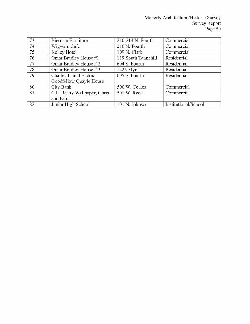
Moberly Architectural/Historic Survey Survey Report
Page 50
73 Bierman Furniture 210-214 N. Fourth Commercial 74 Wigwam Cafe 216 N. Fourth Commercial 75 Kelley Hotel 109 N. Clark Commercial 76 Omar Bradley House #1 119 South Tannehill Residential 77 Omar Bradley House # 2 604 S. Fourth Residential 78 Omar Bradley House # 3 1226 Myra Residential 79 Charles L. and Eudora
Goodfellow Quayle House 605 S. Fourth Residential
80 City Bank 500 W. Coates Commercial 81 C.P. Beatty Wallpaper, Glass
and Paint 501 W. Reed Commercial
82 Junior High School 101 N. Johnson Institutional/School
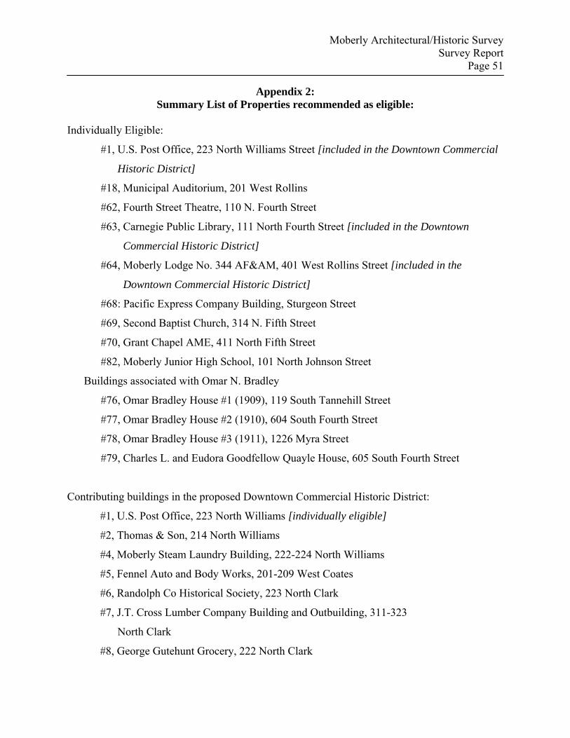
Moberly Architectural/Historic Survey Survey Report
Page 51
Appendix 2: Summary List of Properties recommended as eligible:
Individually Eligible:
#1, U.S. Post Office, 223 North Williams Street [included in the Downtown Commercial
Historic District]
#18, Municipal Auditorium, 201 West Rollins
#62, Fourth Street Theatre, 110 N. Fourth Street
#63, Carnegie Public Library, 111 North Fourth Street [included in the Downtown
Commercial Historic District]
#64, Moberly Lodge No. 344 AF&AM, 401 West Rollins Street [included in the
Downtown Commercial Historic District]
#68: Pacific Express Company Building, Sturgeon Street
#69, Second Baptist Church, 314 N. Fifth Street
#70, Grant Chapel AME, 411 North Fifth Street
#82, Moberly Junior High School, 101 North Johnson Street
Buildings associated with Omar N. Bradley
#76, Omar Bradley House #1 (1909), 119 South Tannehill Street
#77, Omar Bradley House #2 (1910), 604 South Fourth Street
#78, Omar Bradley House #3 (1911), 1226 Myra Street
#79, Charles L. and Eudora Goodfellow Quayle House, 605 South Fourth Street
Contributing buildings in the proposed Downtown Commercial Historic District:
#1, U.S. Post Office, 223 North Williams [individually eligible]
#2, Thomas & Son, 214 North Williams
#4, Moberly Steam Laundry Building, 222-224 North Williams
#5, Fennel Auto and Body Works, 201-209 West Coates
#6, Randolph Co Historical Society, 223 North Clark
#7, J.T. Cross Lumber Company Building and Outbuilding, 311-323
North Clark
#8, George Gutehunt Grocery, 222 North Clark
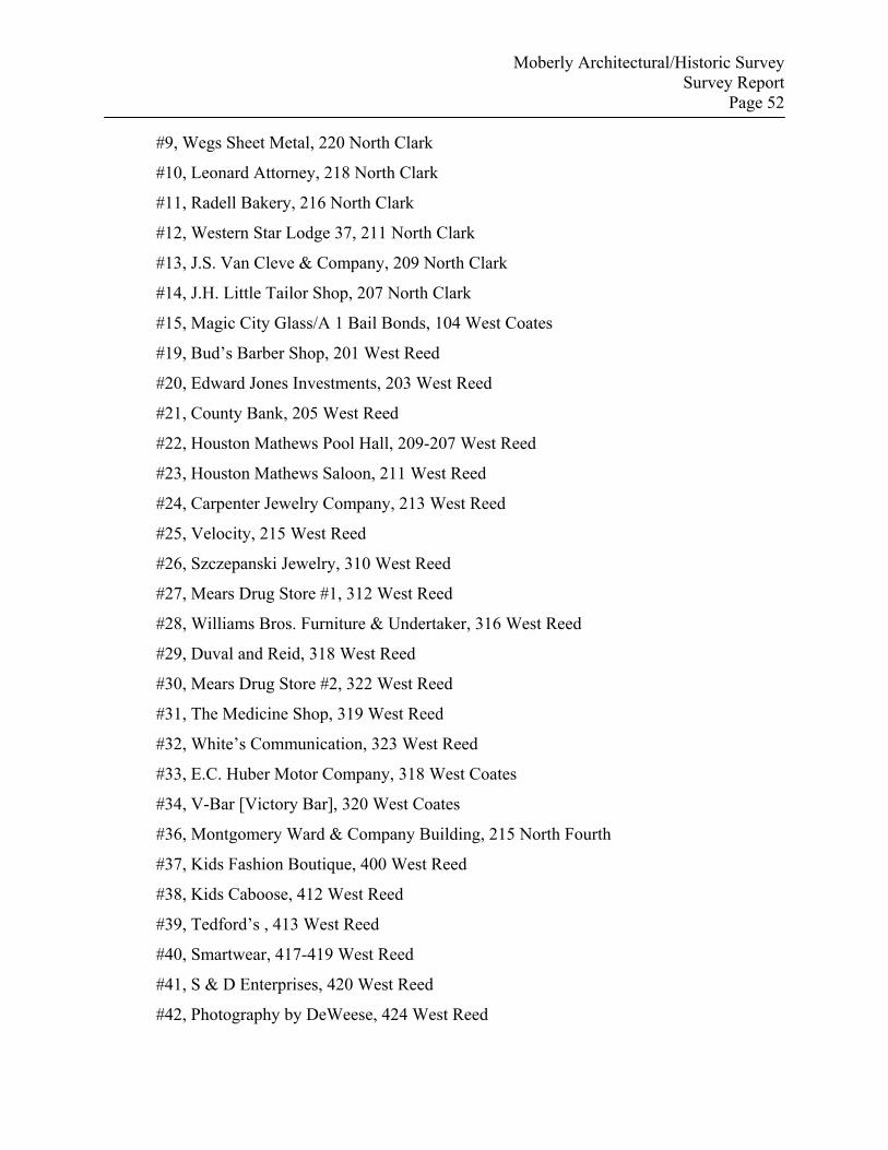
Moberly Architectural/Historic Survey Survey Report
Page 52
#9, Wegs Sheet Metal, 220 North Clark
#10, Leonard Attorney, 218 North Clark
#11, Radell Bakery, 216 North Clark
#12, Western Star Lodge 37, 211 North Clark
#13, J.S. Van Cleve & Company, 209 North Clark
#14, J.H. Little Tailor Shop, 207 North Clark
#15, Magic City Glass/A 1 Bail Bonds, 104 West Coates
#19, Bud’s Barber Shop, 201 West Reed
#20, Edward Jones Investments, 203 West Reed
#21, County Bank, 205 West Reed
#22, Houston Mathews Pool Hall, 209-207 West Reed
#23, Houston Mathews Saloon, 211 West Reed
#24, Carpenter Jewelry Company, 213 West Reed
#25, Velocity, 215 West Reed
#26, Szczepanski Jewelry, 310 West Reed
#27, Mears Drug Store #1, 312 West Reed
#28, Williams Bros. Furniture & Undertaker, 316 West Reed
#29, Duval and Reid, 318 West Reed
#30, Mears Drug Store #2, 322 West Reed
#31, The Medicine Shop, 319 West Reed
#32, White’s Communication, 323 West Reed
#33, E.C. Huber Motor Company, 318 West Coates
#34, V-Bar [Victory Bar], 320 West Coates
#36, Montgomery Ward & Company Building, 215 North Fourth
#37, Kids Fashion Boutique, 400 West Reed
#38, Kids Caboose, 412 West Reed
#39, Tedford’s , 413 West Reed
#40, Smartwear, 417-419 West Reed
#41, S & D Enterprises, 420 West Reed
#42, Photography by DeWeese, 424 West Reed
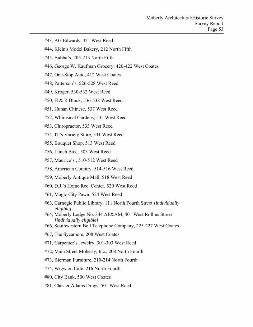
Moberly Architectural/Historic Survey Survey Report
Page 53
#43, AG Edwards, 421 West Reed
#44, Klein's Model Bakery, 212 North Fifth
#45, Bubba’s, 205-213 North Fifth
#46, George W. Kaufman Grocery, 420-422 West Coates
#47, One-Stop Auto, 412 West Coates
#48, Patterson’s, 526-528 West Reed
#49, Kroger, 530-532 West Reed
#50, H & R Block, 536-538 West Reed
#51, Hunan Chinese, 537 West Reed
#52, Whimsical Gardens, 535 West Reed
#53, Chiropractor, 533 West Reed
#54, JT’s Variety Store, 531 West Reed
#55, Bouquet Shop, 513 West Reed
#56, Lunch Box , 503 West Reed
#57, Maurice’s , 510-512 West Reed
#58, American Country, 514-516 West Reed
#59, Moberly Antique Mall, 518 West Reed
#60, D.J.’s Home Rec. Center, 520 West Reed
#61, Magic City Pawn, 524 West Reed
#63, Carnegie Public Library, 111 North Fourth Street [individually eligible]
#64, Moberly Lodge No. 344 AF&AM, 401 West Rollins Street [individually eligible]
#66, Southwestern Bell Telephone Company, 225-227 West Coates
#67, The Sycamore, 208 West Coates
#71, Carpenter’s Jewelry, 301-303 West Reed
#72, Main Street Moberly, Inc., 208 North Fourth
#73, Bierman Furniture, 210-214 North Fourth
#74, Wigwam Cafe, 216 North Fourth
#80, City Bank, 500 West Coates
#81, Chester Adams Drugs, 501 West Reed

Moberly Architectural/Historic Survey Survey Report
Page 54
Contributing buildings in the proposed Levee Historic District: #16, Star Billiard Hall, 124 West Reed
#17, Tony’s, 118 West Reed
#65, National Dairy Lunch, 120 West Reed
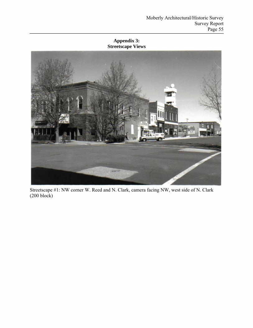
Moberly Architectural/Historic Survey Survey Report
Page 55
Appendix 3: Streetscape Views
Streetscape #1: NW corner W. Reed and N. Clark, camera facing NW, west side of N. Clark (200 block)
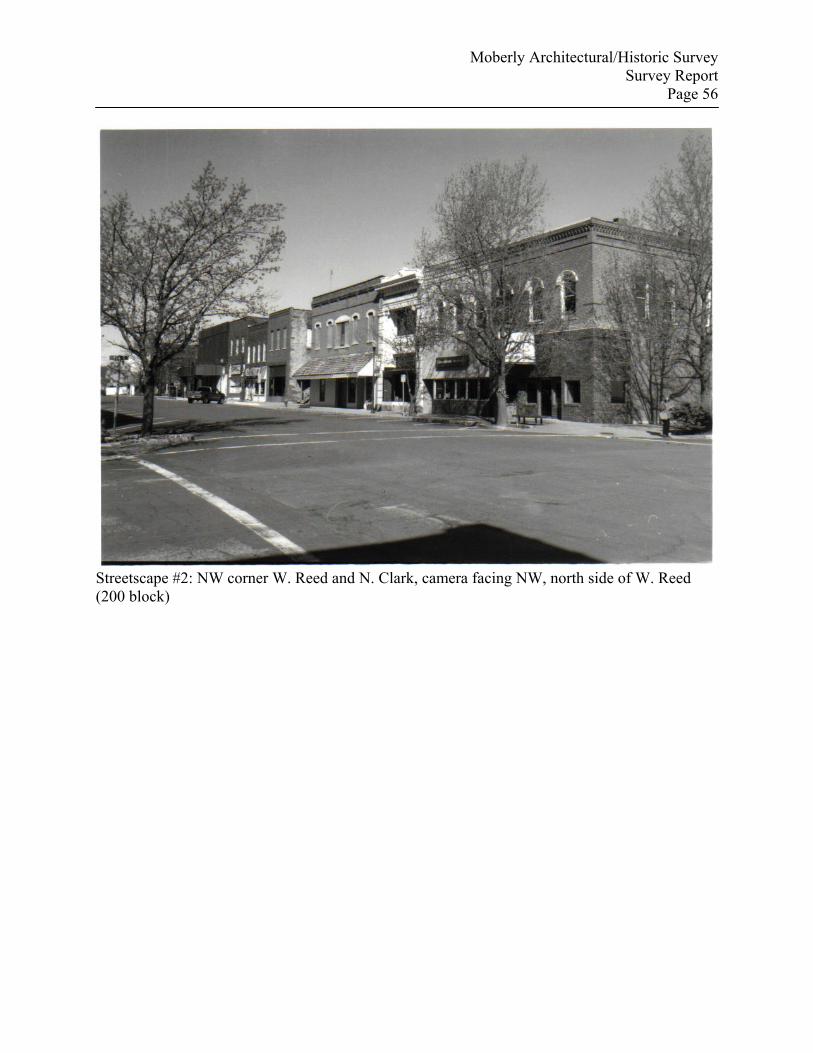
Moberly Architectural/Historic Survey Survey Report
Page 56
Streetscape #2: NW corner W. Reed and N. Clark, camera facing NW, north side of W. Reed (200 block)
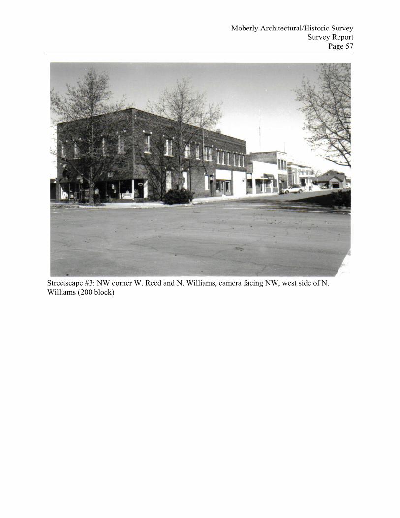
Moberly Architectural/Historic Survey Survey Report
Page 57
Streetscape #3: NW corner W. Reed and N. Williams, camera facing NW, west side of N. Williams (200 block)
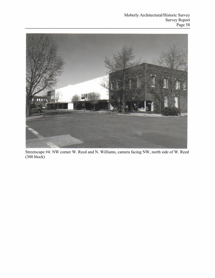
Moberly Architectural/Historic Survey Survey Report
Page 58
Streetscape #4: NW corner W. Reed and N. Williams, camera facing NW, north side of W. Reed (300 block)
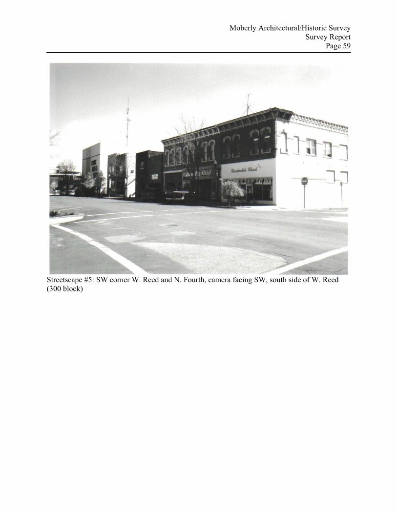
Moberly Architectural/Historic Survey Survey Report
Page 59
Streetscape #5: SW corner W. Reed and N. Fourth, camera facing SW, south side of W. Reed (300 block)
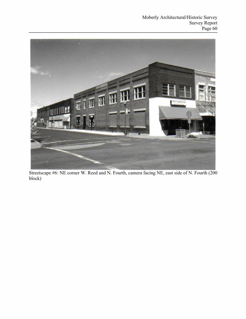
Moberly Architectural/Historic Survey Survey Report
Page 60
Streetscape #6: NE corner W. Reed and N. Fourth, camera facing NE, east side of N. Fourth (200 block)
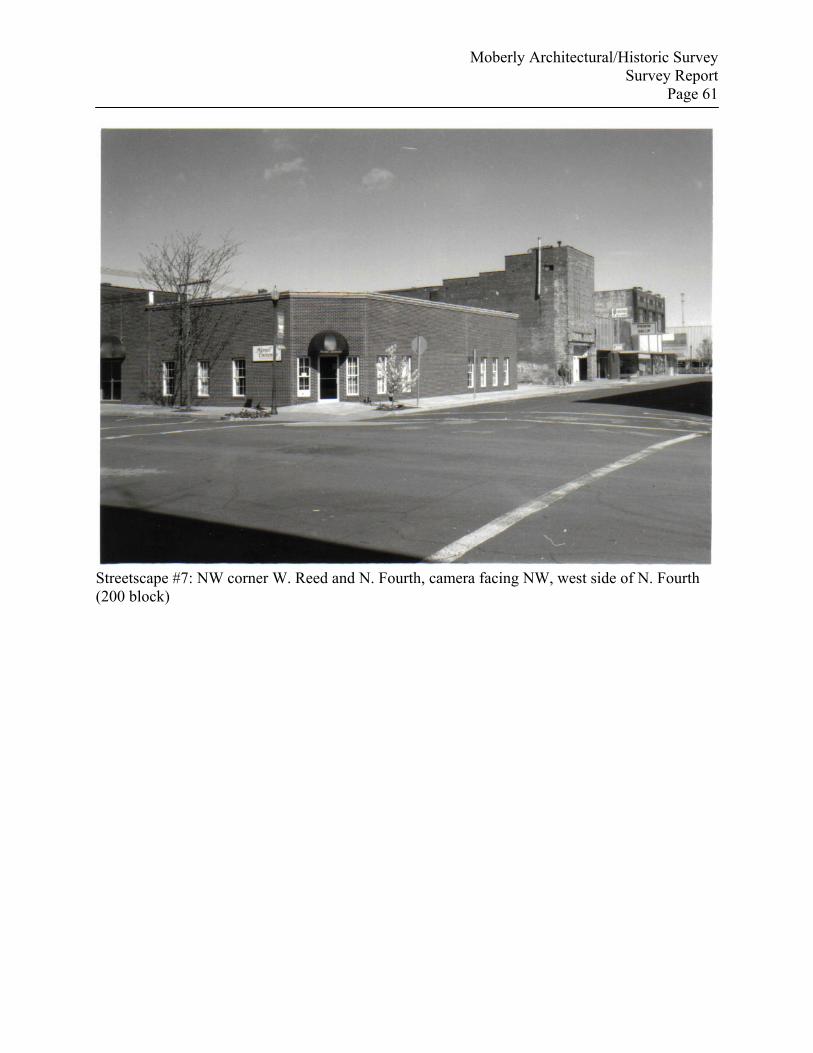
Moberly Architectural/Historic Survey Survey Report
Page 61
Streetscape #7: NW corner W. Reed and N. Fourth, camera facing NW, west side of N. Fourth (200 block)
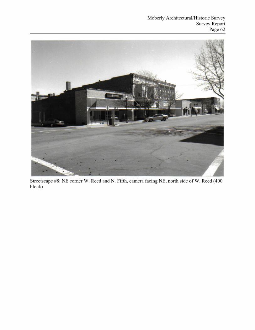
Moberly Architectural/Historic Survey Survey Report
Page 62
Streetscape #8: NE corner W. Reed and N. Fifth, camera facing NE, north side of W. Reed (400 block)
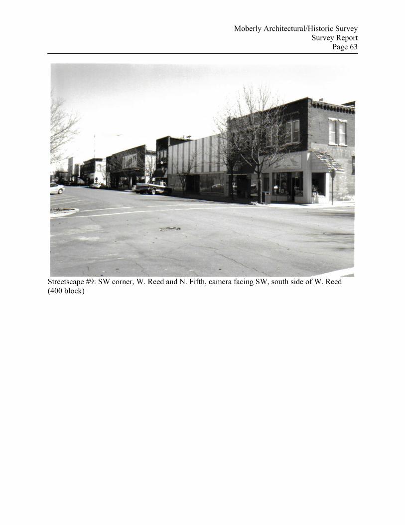
Moberly Architectural/Historic Survey Survey Report
Page 63
Streetscape #9: SW corner, W. Reed and N. Fifth, camera facing SW, south side of W. Reed (400 block)
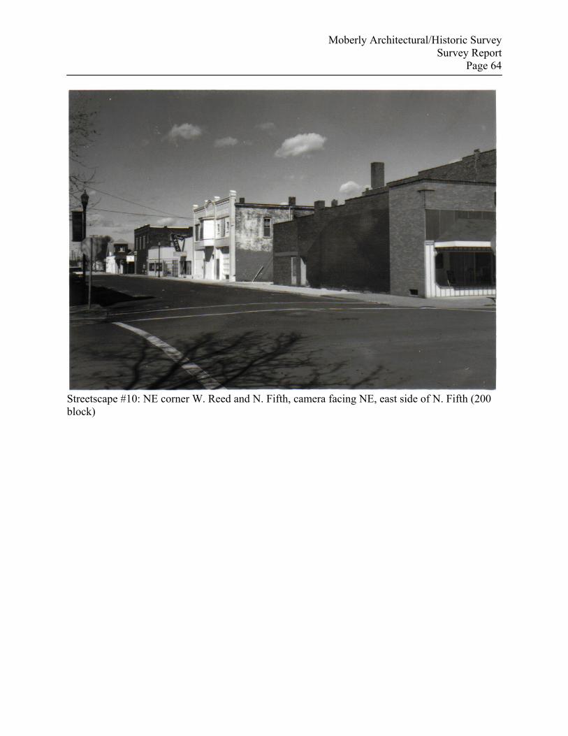
Moberly Architectural/Historic Survey Survey Report
Page 64
Streetscape #10: NE corner W. Reed and N. Fifth, camera facing NE, east side of N. Fifth (200 block)
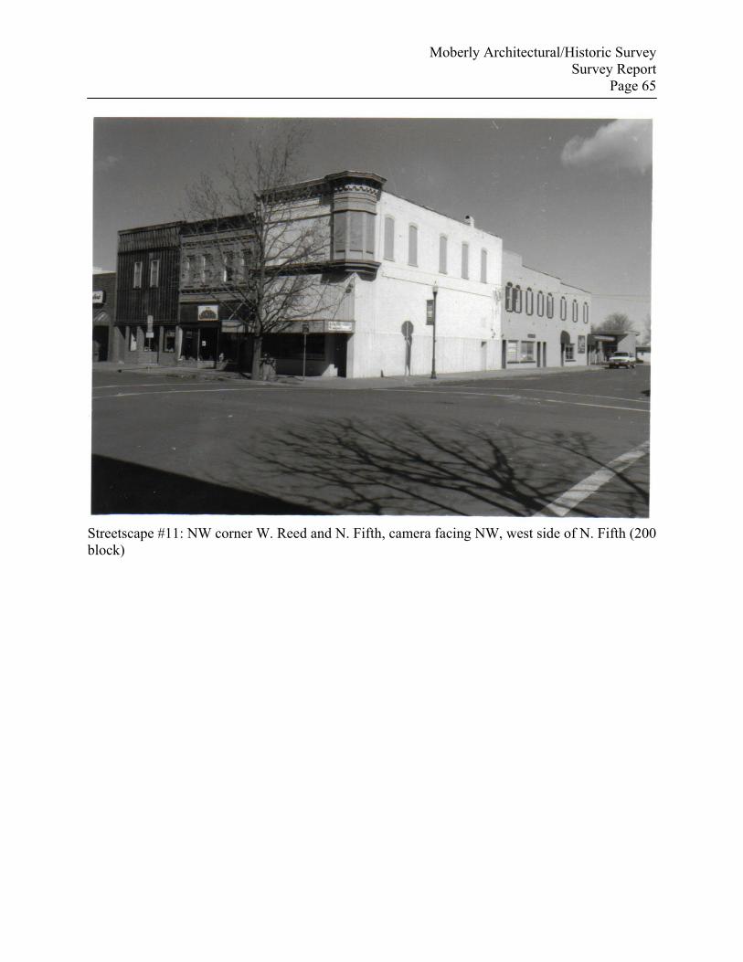
Moberly Architectural/Historic Survey Survey Report
Page 65
Streetscape #11: NW corner W. Reed and N. Fifth, camera facing NW, west side of N. Fifth (200 block)
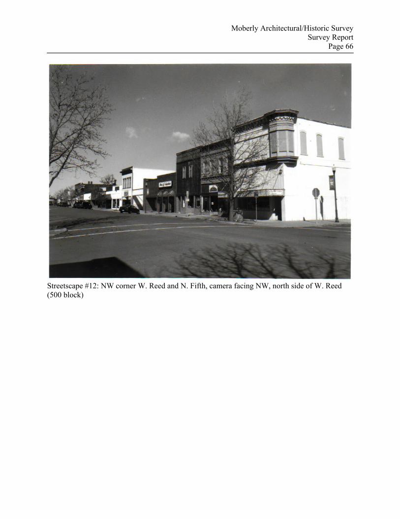
Moberly Architectural/Historic Survey Survey Report
Page 66
Streetscape #12: NW corner W. Reed and N. Fifth, camera facing NW, north side of W. Reed (500 block)
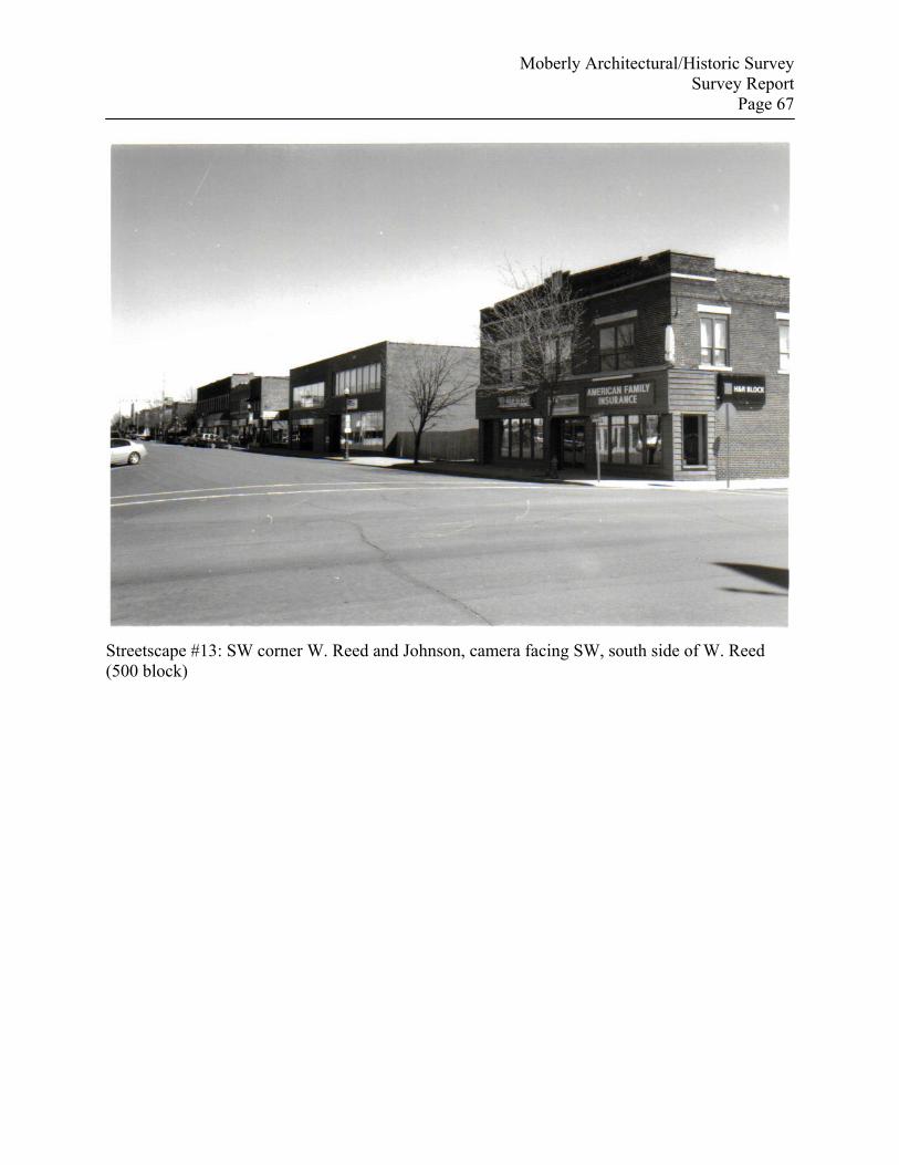
Moberly Architectural/Historic Survey Survey Report
Page 67
Streetscape #13: SW corner W. Reed and Johnson, camera facing SW, south side of W. Reed (500 block)
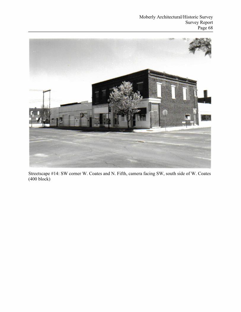
Moberly Architectural/Historic Survey Survey Report
Page 68
Streetscape #14: SW corner W. Coates and N. Fifth, camera facing SW, south side of W. Coates (400 block)
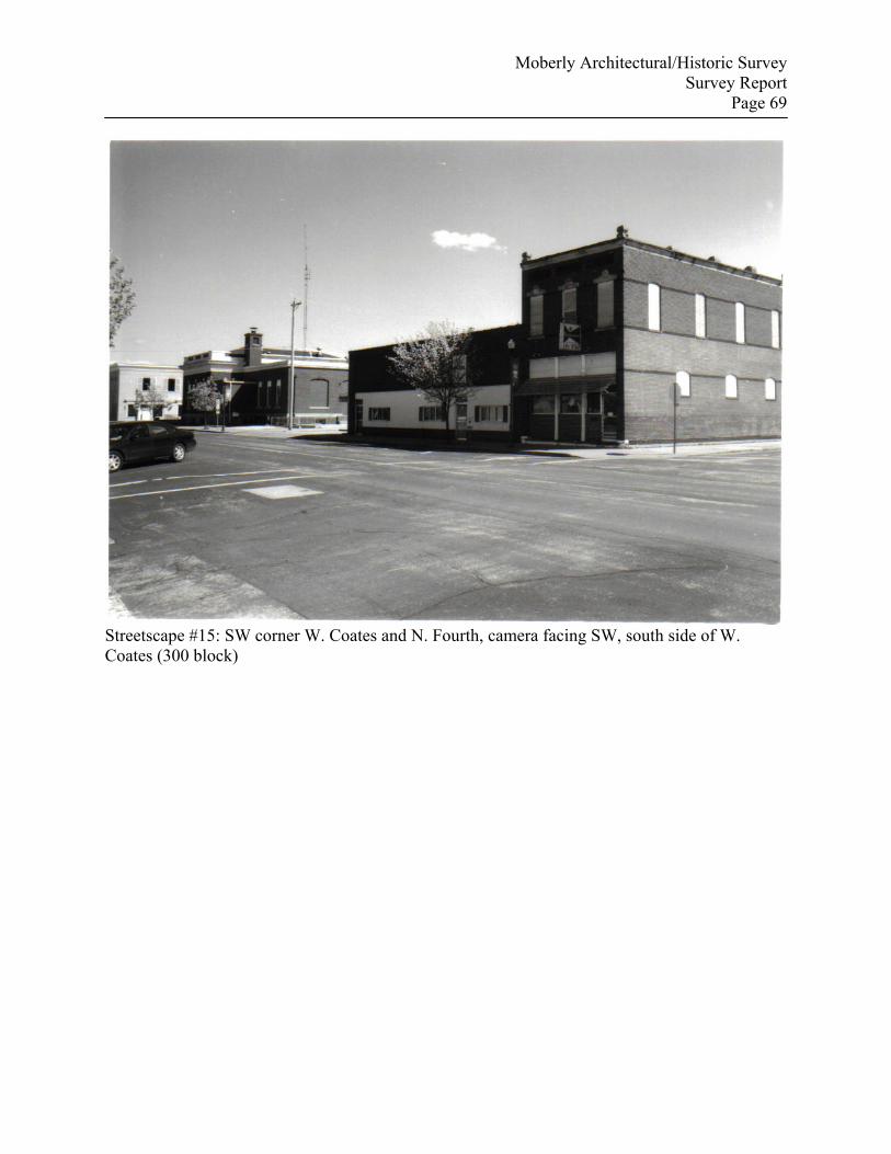
Moberly Architectural/Historic Survey Survey Report
Page 69
Streetscape #15: SW corner W. Coates and N. Fourth, camera facing SW, south side of W. Coates (300 block)
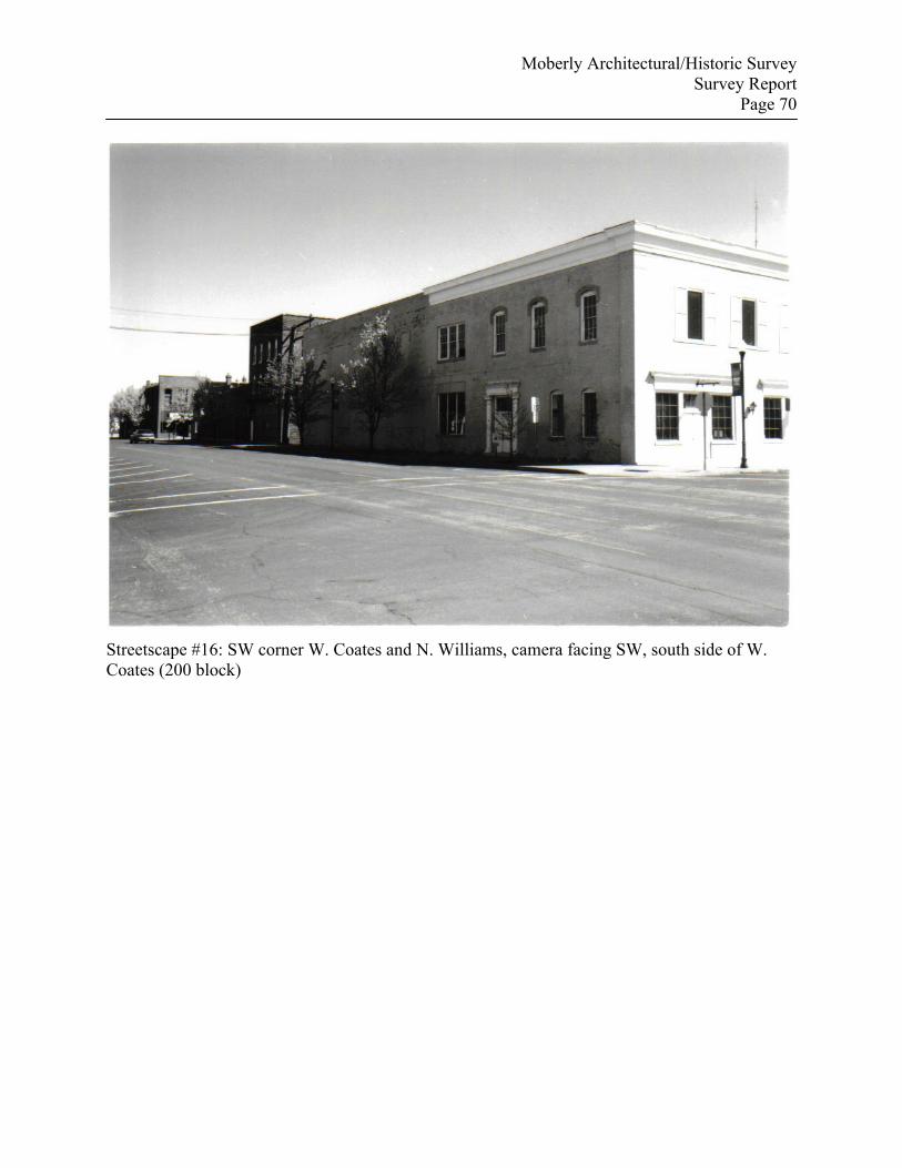
Moberly Architectural/Historic Survey Survey Report
Page 70
Streetscape #16: SW corner W. Coates and N. Williams, camera facing SW, south side of W. Coates (200 block)
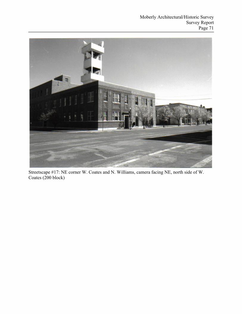
Moberly Architectural/Historic Survey Survey Report
Page 71
Streetscape #17: NE corner W. Coates and N. Williams, camera facing NE, north side of W. Coates (200 block)