Embed Size (px)
Citation preview

HAL Id: hal-00701118https://hal.archives-ouvertes.fr/hal-00701118
Submitted on 24 May 2012
HAL is a multi-disciplinary open accessarchive for the deposit and dissemination of sci-entific research documents, whether they are pub-lished or not. The documents may come fromteaching and research institutions in France orabroad, or from public or private research centers.
L’archive ouverte pluridisciplinaire HAL, estdestinée au dépôt et à la diffusion de documentsscientifiques de niveau recherche, publiés ou non,émanant des établissements d’enseignement et derecherche français ou étrangers, des laboratoirespublics ou privés.
Survey of Wireless Geolocation TechniquesAna Roxin, Jaafar Gaber, Maxime Wack, Ahmed Nait Sidi Moh
To cite this version:Ana Roxin, Jaafar Gaber, Maxime Wack, Ahmed Nait Sidi Moh. Survey of Wireless GeolocationTechniques. 50th IEEE Globecom07, Nov 2007, Washington DC, United States. �hal-00701118�

Abstract—Ubiquitous and pervasive networks and applications
include a growing number of research themes. In most use cases,
applications require location information to interpret their
environment and behave accordingly. In this paper, location
algorithms and positioning methods that can be used for wireless
geolocation are presented.
Index Terms—Wireless geolocation, localization techniques,
localization algorithms, AOA, TDOA, OTDOA, UTDOA, RSS,
GPS, A-GPS, location-aware, pervasive computing, ubiquitous
computing.
I. INTRODUCTION
Locating mobile devices has always been a critical problem. It
becomes even essential today, as the number of location-aware
applications is continuously growing. Acquiring the location
information of mobile devices enables the design of new
value-added B2C and B2B applications and services.
Although GPS-based positioning is reliable and accurate for
outdoor situations, it does not provide acceptable performance
for indoor and urban areas. Other technologies have been
developed with the aim of implementing the specificities of
ubiquitous and pervasive environments. In this paper, main
algorithms and positioning techniques used for wireless
geolocation are presented.
II. WIRELESS GEOLOCATION SYSTEM
A wireless geolocation system has three major components
(Figure 1):
� The location sensing device that allows determining the
relative position of the mobile device,
� The positioning algorithm that estimates the position of
the mobile device by computing metrics from the location
sensing device,
� The display system, which displays the computed position
of the mobile device.
Figure 1. A wireless geolocation system
Two categories of localization techniques have been isolated:
� Dedicated techniques – methods that require the
deployment of a dedicated infrastructure and specific
hardware and software technologies (for example IR, RF,
etc.).
� Non-dedicated techniques – methods that can use a
network to compute a position.
Only non-dedicated methods are discussed in this paper, since
they are best suited for ubiquitous and pervasive environments.
Dedicated methods provide a high degree of accuracy, but
need expensive, energy-consuming and scale-limited
equipments. One may found various papers describing existing
dedicated methods [1-5].
The rest of the paper is organized as follows. In section III,
localization algorithms are presented. In section IV,
positioning methods are described. A conclusion is given in
section V. Section VI provides definitions for all the acronyms
cited in the text.
III. LOCALIZATION ALGORITHMS
In this section, algorithms used by non-dedicated localization
techniques are described. To ease the understanding, first are
reviewed fundamental principles employed by these
techniques. Then an introduction to recent researches will be
made.
A. Principles
There are two fundamental principles used in traditional
localization techniques: trilateration and triangulation.
Wireless Geolocation Techniques
A Survey
A. Roxin, J. Gaber, M. Wack, A.Nait-Sidi-Moh
Université de Technologie de Belfort-Montbéliard (UTBM)
90010 Belfort, France

1) Trilateration
This method computes the distance between a BS and the
mobile device. It requires 3 BSs. The position of the mobile
device is determined using an RF location sensing technique.
The mobile device is located by the intersection point of 3
circles. Each circle has for radius the distance between the
mobile device and the considered BS as illustrated in Figures
2a and 2b.
Figure 2a. Locating the mobile device by the intersection of three
circles with radii d1, d2 and d3.
Figure 2b. Locating the mobile device by performing a TDOA.
2) Triangulation
This method is based on the estimation of the direction of
arrival of a signal from the mobile device, as illustrated in
Figure 3. AoA (presented in section 4.1.4.) is an example of a
positioning method that uses triangulation.
Figure 3. Estimation of the distance between a mobile device
and the BS, using AOA.
B. Radio map
The principle of the radio map is to build a signal strength
model. The location of the mobile device is estimated by
finding a best match from the signal strength model.
This principle comprises two phases:
� The offline phase when the radio map is built. During
this phase, RF signals are collected from several
predefined access points.
� The online phase when the mobile device location is
estimated. During this phase, a location algorithm is used
to find a matching location, starting from the measured
RSS.
Figure 4. Radio map.
During the online phase, a localization algorithm is used to
locate the mobile device. Used algorithms are divided into two
categories:
� Algorithms using deterministic techniques.
� Algorithms using probabilistic techniques.
These two categories will be presented in the rest of this
section.
1) Deterministic techniques
Deterministic techniques use scalar values of measured RSS
from APs. The measured values are averaged into a given
location, which is associated to the location of the considered
mobile device.
a) Nearest Neighbor in Signal Space (NNSS)
This method computes the distance between the RSS measured
by the mobile device and all the other RSS in the radio map.
Mobile device location is estimated as the minimal distance
computed, which is the smallest Euclidean distance.
b) Nearest Neighbor in Signal Space – Average (NNSS-
AVG)
This method is similar to the NNSS method. Instead of
choosing only one neighbor, it picks several nearest neighbors
in signal space. The idea is to choose k nearest neighbors and

compute the mobile device location by averaging the
coordinates of the k neighbors.
Figure 5. NNSS-AVG method
c) Smallest polygon
This method is similar to the NNSS-AVG method, but instead
of using the signal domain, it uses the space domain.
Several nearest neighbours are selected (using various
methods) and various polygons are formed. The area of each
polygon is then estimated. The algorithm selects the polygon
with the smallest area. The location of the mobile device is
then estimated as the centre of the previously selected polygon.
Figure 6. Smallest polygon method – candidate locations (A, B, C
and D) form various triangles. The centre of ∆ABC is the estimated
location, since it has the smallest area.
d) Approximate Point-In-Triangulation (APIT)
This algorithm is often applied to wireless sensor
environments. Anchors are selected among the sensing nodes
of a wireless sensor network.
Each anchor broadcasts beacons with location information
about the anchor position. A node receives beacons from a set
of N audible anchors. It then builds triangles from the N
audible anchors. The mobile device tests whether it is inside or
outside each triangle. This step is called the APIT testing. The
area where the most triangles overlap is the most probable area
for the location of the mobile device. This is the APIT
aggregation [6]. A SCAN approach is used to determine the
maximum area where the mobile device is located. Once this
area is determined, its center of gravity is calculated and
considered as the location of the mobile device.
Figure 7. Overview of the APIT algorithm.
Figure 8. (a) A node is inside the triangle. (b) A node is outside the
triangle.
Figure 9. Using SCAN approach to execute APIT aggregation.
2) Probabilistic techniques
Probabilistic techniques use RSS distributions received from
every AP. RSS are values that vary in time, as they depend on
environments factors [8-11].
The main idea is to assume that RSS distributions are similar
to Gaussian probability distributions. During the offline phase,
for each AP, a mean and a variance value are computed for the
received RSS distribution. Probabilities are then computed for
each predefined location, according to the radio map. The
most probable location is estimated as the location of the
considered mobile device.
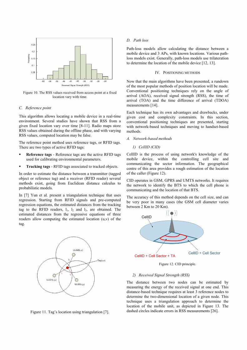
Figure 10. The RSS values received from access point at a fixed
location vary with time.
C. Reference point
This algorithm allows locating a mobile device in a real-time
environment. Several studies have shown that RSS from a
given fixed location vary over time [8-11]. Radio maps store
RSS values obtained during the offline phase, and with varying
RSS values, computed location may be false.
The reference point method uses reference tags, or RFID tags.
There are two types of active RFID tags:
� Reference tags - Reference tags are the active RFID tags
used for calibrating environmental parameters.
� Tracking tags - RFID tags associated to tracked objects.
In order to estimate the distance between a transmitter (tagged
object or reference tag) and a receiver (RFID reader) several
methods exist, going from Euclidean distance calculus to
probabilistic models.
In [7] Yun et al. present a triangulation technique that uses
regression. Starting from RFID signals and pre-computed
regression equations, the estimated distances from the tracking
tag to the RFID readers, l1, l2 and l3, are obtained. The
estimated distances from the regressive equations of three
readers allow computing the estimated location (u,v) of the
tag.
Figure 11. Tag’s location using triangulation [7].
D. Path loss
Path-loss models allow calculating the distance between a
mobile device and 3 APs, with known locations. Various path-
loss models exist. Generally, path-loss models use trilateration
to determine the location of the mobile device [12, 13].
IV. POSITIONING METHODS
Now that the main algorithms have been presented, a rundown
of the most popular methods of position location will be made.
Conventional positioning techniques rely on the angle of
arrival (AOA), received signal strength (RSS), the time of
arrival (TOA) and the time difference of arrival (TDOA)
measurements [14].
Each technique has its own advantages and drawbacks, under
given cost and complexity constraints. In this section,
conventional positioning techniques are presented, starting
with network-based techniques and moving to handset-based
methods.
A. Network-based methods
1) CellID (CID)
CellID is the process of using network's knowledge of the
mobile device, within the controlling cell site and
communicating the sector information. The geographical
centre of this area provides a rough estimation of the location
of the caller (Figure 12).
CID operates in GSM, GPRS and UMTS networks. It requires
the network to identify the BTS to which the cell phone is
communicating and the location of that BTS.
The accuracy of this method depends on the cell size, and can
be very poor in many cases (the GSM cell diameter varies
between 2 Km to 20 Km).
Figure 12. CID principle.
2) Received Signal Strength (RSS)
The distance between two nodes can be estimated by
measuring the energy of the received signal at one end. This
distance-based technique requires at least 3 reference nodes to
determine the two-dimensional location of a given node. This
technique uses a triangulation approach to determine the
location of the mobile unit, as depicted in Figure 13. The
dashed circles indicate errors in RSS measurements [26].
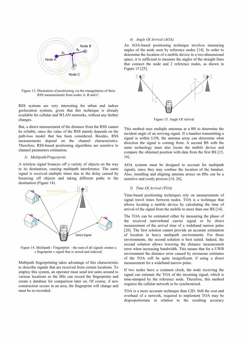
Figure 13. Illustration of positioning via the triangulation of three
RSS measurements from nodes A, B and C.
RSS systems are very interesting for urban and indoor
geolocation systems, given that this technique is already
available for cellular and WLAN networks, without any further
changes.
But, a direct measurement of the distance from the RSS cannot
be reliable, since the value of the RSS mainly depends on the
path-loss model that has been considered. Besides, RSS
measurements depend on the channel characteristics.
Therefore, RSS-based positioning algorithms are sensitive to
channel parameters estimation.
3) Multipath/Fingerprint
A wireless signal bounces off a variety of objects on the way
to its destination, causing multipath interference. The same
signal is received multiple times due to the delay caused by
bouncing off objects and taking different paths to the
destination (Figure 14).
Figure 14. Multipath / Fingerprint – the sum of all signals creates a
« fingerprint » signal that is stored and indexed.
Multipath fingerprinting takes advantage of this characteristic
to describe signals that are received from certain locations. To
employ this system, an operator must send test units around to
various locations so the BSs can record the fingerprints and
create a database for comparison later on. Of course, if new
construction occurs in an area, the fingerprint will change and
must be re-recorded.
4) Angle Of Arrival (AOA)
An AOA-based positioning technique involves measuring
angles of the node seen by reference nodes [14]. In order to
determine the location of a mobile device in a two-dimensional
space, it is sufficient to measure the angles of the straight lines
that connect the node and 2 reference nodes, as shown in
Figure 15 [25].
Figure 15. Angle Of Arrival
This method uses multiple antennas at a BS to determine the
incident angle of an arriving signal. If a handset transmitting a
signal is within LOS, the antenna array can determine what
direction the signal is coming from. A second BS with the
same technology must also locate the mobile device and
compare the obtained position with data from the first BS [15,
16].
AOA systems must be designed to account for multipath
signals, since they may confuse the location of the handset.
Also, installing and aligning antenna arrays on BSs can be a
sensitive and costly process [14, 26].
5) Time Of Arrival (TOA)
Time-based positioning techniques rely on measurements of
signal travel times between nodes. TOA is a technique that
allows locating a mobile device by calculating the time of
arrival of the signal from the mobile to more than one BS [14].
The TOA can be estimated either by measuring the phase of
the received narrowband carrier signal or by direct
measurement of the arrival time of a wideband narrow pulse
[26]. The first solution cannot provide an accurate estimation
of location in heavy multipath environments. For those
environments, the second solution is best suited. Indeed, the
second solution allows lowering the distance measurement
error when increasing bandwidth. This means that for a UWB
environment the distance error caused by erroneous estimates
of the TOA will be quite insignificant, if using a direct
measurement for a wideband narrow pulse.
If two nodes have a common clock, the node receiving the
signal can estimate the TOA of the incoming signal, which is
time-stamped by the reference node. Therefore, this method
requires the cellular network to be synchronized.
TOA is a more accurate technique than CID. Still the cost and
overhaul of a network, required to implement TOA may be
disproportionate in relation to the resulting accuracy
enhancement, unless service providers supply their own
overlay service to attach to a network [26].
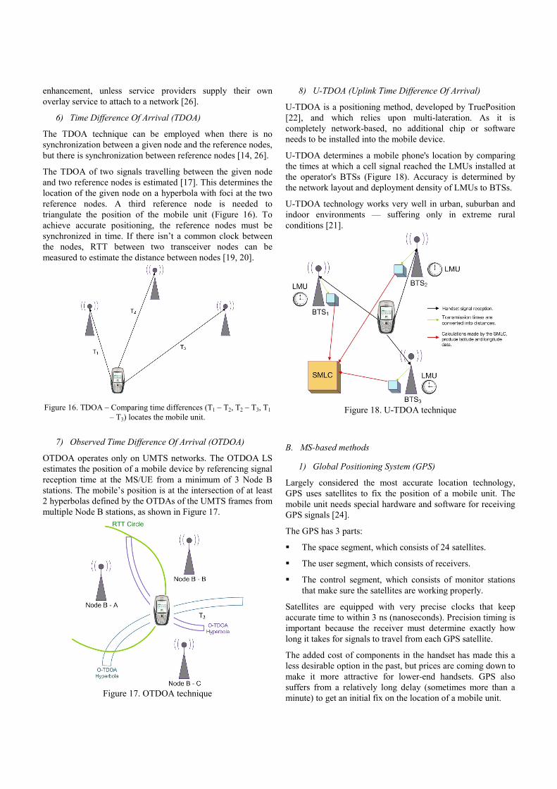
6) Time Difference Of Arrival (TDOA)
The TDOA technique can be employed when there is no
synchronization between a given node and the reference nodes,
but there is synchronization between reference nodes [14, 26].
The TDOA of two signals travelling between the given node
and two reference nodes is estimated [17]. This determines the
location of the given node on a hyperbola with foci at the two
reference nodes. A third reference node is needed to
triangulate the position of the mobile unit (Figure 16). To
achieve accurate positioning, the reference nodes must be
synchronized in time. If there isn’t a common clock between
the nodes, RTT between two transceiver nodes can be
measured to estimate the distance between nodes [19, 20].
Figure 16. TDOA – Comparing time differences (T1 – T2, T2 – T3, T1
– T3) locates the mobile unit.
7) Observed Time Difference Of Arrival (OTDOA)
OTDOA operates only on UMTS networks. The OTDOA LS
estimates the position of a mobile device by referencing signal
reception time at the MS/UE from a minimum of 3 Node B
stations. The mobile’s position is at the intersection of at least
2 hyperbolas defined by the OTDAs of the UMTS frames from
multiple Node B stations, as shown in Figure 17.
Figure 17. OTDOA technique
8) U-TDOA (Uplink Time Difference Of Arrival)
U-TDOA is a positioning method, developed by TruePosition
[22], and which relies upon multi-lateration. As it is
completely network-based, no additional chip or software
needs to be installed into the mobile device.
U-TDOA determines a mobile phone's location by comparing
the times at which a cell signal reached the LMUs installed at
the operator's BTSs (Figure 18). Accuracy is determined by
the network layout and deployment density of LMUs to BTSs.
U-TDOA technology works very well in urban, suburban and
indoor environments — suffering only in extreme rural
conditions [21].
Figure 18. U-TDOA technique
B. MS-based methods
1) Global Positioning System (GPS)
Largely considered the most accurate location technology,
GPS uses satellites to fix the position of a mobile unit. The
mobile unit needs special hardware and software for receiving
GPS signals [24].
The GPS has 3 parts:
� The space segment, which consists of 24 satellites.
� The user segment, which consists of receivers.
� The control segment, which consists of monitor stations
that make sure the satellites are working properly.
Satellites are equipped with very precise clocks that keep
accurate time to within 3 ns (nanoseconds). Precision timing is
important because the receiver must determine exactly how
long it takes for signals to travel from each GPS satellite.
The added cost of components in the handset has made this a
less desirable option in the past, but prices are coming down to
make it more attractive for lower-end handsets. GPS also
suffers from a relatively long delay (sometimes more than a
minute) to get an initial fix on the location of a mobile unit.

2) Assisted GPS (A-GPS)
A-GPS systems are set up to resolve the long delay that can
occur in locating a mobile unit when using GPS. Data about
the mobile unit is transmitted through the network of BSs to
speed up the location process, bringing it down to only a few
seconds. This occurs when obstructions block the view from a
handset to a GPS satellite [23].
Wireless A-GPS operates on GSM, GPRS and UMTS
networks. Like GPS, A-GPS uses satellites in space as
reference points to determine location.
A-GPS can be accurate up to 10 meters.
A-GPS provides better accuracy than CID, E-OTD or
OTDOA, and operates on asynchronous or synchronous
networks without the need for LMUs (although LMU
information can be used if it is available) [21].
Figure 20. A-GPS Principle
An A-GPS implementation has almost negligible impact on the
infrastructure and can easily support roaming, but requires A-
GPS circuitry inside the phone. A-GPS requires message
exchanges with an A-GPS LS in the infrastructure, but this is
handled in a flexible manner and exchanged messages are
small-sized [24].
3) Enhanced – Observed Time Difference (E-OTD)
This technology has been deployed by Cambridge Position
Systems. E-OTD operates only on GSM and GPRS networks.
The cell phone sends a signal to the surrounding cell emitters,
and the nearest one sends back the signal. The time taken
between sending and receiving the wave is analyzed by an
external server, which calculates the cell phone position in the
network
(www.mobileinfo.com/LocationBasedServices/E_OTD.htm).
This method includes new technology in the handset to assist
in locating the unit in a network. Mobile units in an E-OTD
system are set up to support positioning in a network where
BSs are asynchronous.
Theoretically, it takes about 5 seconds to locate a mobile using
the E-OTD technique and the accuracy is about 30 - 50 meters.
Real-world tests have yielded less accurate measurements of
about 50 - 125 meters [22]. The accuracy of the E-OTD
method is a function of the resolution of the time difference
measurements, the geometry of the neighboring base stations,
and the signal environment.
E-OTD solutions offer improved performance relative to CID,
but require the use of LMUs. This increases the cost and
complexity of implementation, as described above. E-OTD
also requires a large number of data messages be exchanged to
provide location information, and this information must be
updated constantly [22].
Figure 21. E-OTD Principle.
The message traffic is much greater than that used for A-GPS
or CID. E-OTD uses more network bandwidth than all other
technologies. This technology is vulnerable to accuracy
degradation from multipath and signal reflections.
V. CONCLUSION
Each of the above-described methods has its own advantages
and inconvenients. Due to their high resolution capacity in the
time domain, time-based positioning algorithms are usually
preferred to those involving AOA or RSS measurements.
Although these algorithms enable very accurate positioning,
they also poses some challenges for practical systems (require
installation of dedicated hardware).
The reference point method may provide more accurate
positions, without dealing with the above mentioned
challenges. Moreover, if RSS is taken as a major parameter to
estimate the position of a mobile device, the localization will
be easy to design, as most adapters provide RSS measurement.
VI. ACRONYMS
AP – Access Point – The AP is a device that connects
wireless communication devices together to form a wireless
network.
APIT - Approximate Point In Triangle Test - APIT employs
a novel area-based approach. Anchors divide terrain into
triangular regions. A node’s presence inside or outside of these
triangular regions allows a node to narrow the area in which it
can potentially reside.
Autonomous - Term typically used in GPS and wireless A-
GPS implementations. A mode of operation in which the MS
calculates a position with no aiding from the location server.
This mode is also referred to as “standalone” mode, and is
commonly the mode in which conventional GPS receivers
operate.
A-GPS - Assisted GPS – Aided GPS, or shortened version of
Wireless Assisted GPS.
AOA - Angle of Arrival - A location technology that uses
special antenna arrays at BTS sites to determine the angle of
arrival of handset signals. At least two AOA measurements are
then combined to identity the position of the handset.
BS – Base Station - In the context of external land surveying,
a base station is a GPS receiver at an accurately-known fixed
location which is used to derive correction information for
nearby portable GPS receivers. In the area of wireless
computer networking, a base station is a radio
receiver/transmitter that serves as the hub of the local wireless
network, and may also be the gateway between a wired
network and the wireless network. In radio communications, a
base station is a wireless communications station installed at a
fixed location and used to communicate.
BTS - Base Transceiver Station - A base station transceiver
in the wireless communications infrastructure.
CDMA - Code Division Multiple Access - A high-capacity
digital wireless communications technology.
CID – Cell Identification - A location technology that utilizes
the location of the BTS to identify caller location.
E-OTD - Enhanced Observed Time Difference - A
technique comparing the time an MS signal arrives at different
base stations to determine two-dimensional position (altitude
not determined).
GMLC - Gateway Mobile Location Center - The
infrastructure element in 2G, 2.5G and 3G systems that makes
location information available to the location application.
GPRS - GSM Packet Radio System - The packet radio
version of GSM communications.
GPS - Global Positioning System - A technique utilizing
distance measurements to GPS satellites to determine three-
dimensional location (includes altitude).
GSM - Global System for Mobile Communications -
Standard for digital mobile telephony originally developed for
pan-European use, but now used worldwide.
IPDL - Idle Period Down Link - A signalling method used
with OTDOA positioning technology to mitigate the near far
problem inherent to UMTS systems.
IR – InfraRed - Infrared radiation is electromagnetic
radiation of a wavelength longer than that of visible light, but
shorter than that of radio waves. The name means "below red"
(from the Latin “infra”, “below”), red being the colour of
visible light with the longest wavelength.
LMU - Location Measurement Unit - A device used with E-
OTD to provide precise timing information for asynchronous
networks.
LS - Location Server - The software entity used to calculate
position or to provide assistance data or to participate in the
positioning process in some other way. Different location
technologies require different location server functionality. In
report, the LS term will be preceded by a location technology
description to indicate the LS supports that type of location
technology (e.g., an A-GPS LS is a location server that
supports A-GPS technology and therefore provides assistance
data and can calculate a final position).
MS - Mobile Station - The term used in GSM and GPRS
networks to describe a subscriber’s handset or wireless
terminal.
MS-Assisted - Term typically used in wireless assisted GPS
implementations. A mode of operation in which the MS
provides data to the location server to enable the location
server to calculated a position.
MS-Based - Term typically used in wireless assisted GPS
implementations. A mode of operation in which the MS
receives aiding data from the location server to enable the MS
to calculate a position.
MSC - Mobile Switching Center - A primary switching hub
in 2G, 2.5G and 3G wireless network.
Multipath fingerprint - A location technology that uses a
complex database of stored communication signal images, or
“fingerprints” that are each unique to locations throughout the
user network. Real-time handset signals are then compared to
the stored fingerprints to find a match, which produces a
location estimate.
Node B - The term for a base station in a 3G network.
OTDOA - Observed Time Difference of Arrival - A
location technology that compares the time a UE signal arrives
at different base stations to determine two-dimensional
position (altitude not determined).
P-range - Pseudo range - The distance measurement derived
from the elapsed travel time of a GPS signal from a GPS
satellite to a GPS receiver.
RF – Radio Frequency – RF refers to that portion of the
electromagnetic spectrum in which electromagnetic waves can
be generated by alternating current which is fed to an antenna.
RFID – Radio Frequency Identification - RFID is an
automatic identification method, relying on storing and
remotely retrieving data using devices called RFID tags or
transponders. An RFID tag is an object that can be attached to
or incorporated into a product, animal, or person for the
purpose of identification using radio waves.
RSS – Received Signal Strength – RSS is a measurement of
the received radio signal strength (energy integral, not the
quality).
RTT - Round Trip Time - A technique utilizing the total
round-trip time from an MS to a base station to determine the
approximate distance an MS is from a base station.
SAS - Stand-Alone Assisted GPS SMLC - The UMTS
network node that may operate the assisted-GPS location
server software.
SGSN - Serving GPRS Support Node - The node required in
2.5G and 3G systems to provide data support in the core
network.
SMLC - Serving Mobile Location Centre - The GSM/GPRS
network node that operates the location server software.
SNRC - Serving Network Radio Controller - The UMTS
network node that may operate the location server software.
TA - Timing Advance - A technique utilizing the timing
advance information applied by the GSM network to
determine the approximate distance an MS is from a base
station.
TU - Timing Unit - A timing unit required for networks that
are not synchronized. Typically uses special GPS receivers to
provide absolute timing.
TOA - Time of Arrival - A technique comparing the time an
MS signal arrives at different base stations to determine two-
dimensional position (altitude not determined).
Trilateration - A technique used to derive location by
determining the intersection of hyperbolas derived from the
range measurements between a BTS and handset.
TTFF - Time to First Fix - The time elapsed between when a
position was requested and when a position was determined.
Most commonly applied to GPS and A-GPS technologies, but
also applicable for other location technologies.
UE - User Equipment - The term used in UMTS networks to
describe a subscriber’s handset or wireless terminal.
UMTS - Universal Mobile Telecommunications Systems -
UMTS is the third generation (3G) evolution from 2G/2.5G
networks and since it is based on wideband CDMA radio
access technology (WCDMA), it is generally considered
synonymous with WCDMA.
WCDMA - Wideband CDMA - IMT-2000 CDMA direct
spread standard developed by 3GPP.
WLAN – Wireless Local Area Network – A WLAN is a
wireless local area network, which is the linking of two or
more computers without using wires.
Yield - The ratio of the number of successfully calculated
positions (meeting specified quality criteria) to the number of
attempts to determine a position. A yield of 100 percent means
all position attempts resulted in a position calculation within
the boundaries of the specified quality criteria. 50 percent
yield means only one of every two attempts resulted in a
position calculation.

VII. REFERENCES
[1] Want, R., Hopper, A., Falco, V., and Gibbons, J., “The
active badge location system”, ACM Transactions on
Information Systems, Vol. 10, No. 1, pp.91-102, 1992.
[2] Nakazato, Y., Kanbara, M., and Yokoya, N., “Discreet
markers for user localization”, Eighth International
Symposium on Wearable Computers, ISWC 2004, Volume 1,
pp. 172 – 173, 31 October -3 November 2004.
[3] Maeda, M. and Habara, T., “Indoor Localization Methods
for Wearable Mixed Reality”, Second CREST Workshop on
Advanced Computing and Communicating Techniques for
Wearable Information Playing, May 24, 2003.
[4] Natarajan, P. and Nahar, G., “Camera Localization
methods for Intelligent Room Systems using RF and Stereo
Vision Techniques”, SPIE 2004.
[5] Li, Z., Trappe, W., Zhang, Y., and Nath, B., “Robust
Statistical Methods for Securing Wireless Localization in
Sensor Networks”, Fourth International Symposium on
Information Processing in Sensor Networks, IPSN 2005.
[6] He, T., Huang, C., Blum, B. M., Stankovic, J. A., and
Abdelzaher, T., “Range-Free Localization Schemes for Large
Scale Sensor Networks”, MobiCom ’03, 14-19 September
2003.
[7] Yun, K., and Kim, D., “Robust location tracking using a
dual layer particle filter”, Pervasive and Mobile Computing,
Volume 3, Issue 3, pp. 209 – 232, June 2007.
[8] Ladd, A.M., Bekris, K., Rudys, A., Marceau, G., Kavraki,
L.E., and Wallach, D.S., “Robotics-based location sensing
using wireless ethernet”, ACM MOBICOM, pp. 227 – 238,
September 2002.
[9] Haeberlen, A., Flannery, E., Ladd, A.M., Rudys, A.,
Wallach, D.S., and Kavraki, L.E., “Practical robust
localization over large-scale 802.11 wireless networks”, ACM
MOBICOM, pp. 70 - 84, September 2004.
[10] Yin, J., Yang, Q. and Ni, L., “Adaptive temporal radio
maps for indoor location estimation”, IEEE PerCom, pp. 85 -
94, March 2005.
[11] Youssef, M., Agrawala, A., and Shankar, A.U., “WLAN
location determination via clustering and probability
distributions”, IEEE PerCom, pp. 143 – 150, March 2003.
[12] Zhao, X., Rautiainen, T., Kalliola, K., and Vainikainen,
P., “Path-Loss Models for Urban Microcells at 5.3 GHz”,
Antennas and Wireless Propagation Letters, Volume 5, Issue
1, pp. 152 – 154, December 2006.
[13] Abhayawardhana, V.S., Wassell, I.J., Crosby, D., Sellars,
M.P., and Brown, M.G., “Comparison of Empirical
Propagation Path Loss Models for Fixed Wireless Access
Systems”, VTC 2005.
[14] Caffery, J. J., “Wireless location in CDMA Cellular
Radio Systems”, Kluwer Academic, Boston, 2000.
[15] Chen, J.-C., Ting, P., Maa, C.-S., and Chen, J.-T.,
“Wireless geolocation with TOA/AOA measurements using
factor graph and sum-product algorithm”, IEEE 60th
Vehicular Technology Conference, Volume 5, pp. 3526 -
3529, 26-29 September 2004.
[16] Li, W., and Liu, P., “3D AOA/TDOA emitter location by
integrated passive radar/GPS/INS systems”, Proceedings of
2005 IEEE International Workshop on VLSI Design and
Video Technology, pp. 121 – 124, 28-30 May 2005.
[17] Yao, Q., Tan, S.-K., Ge, Y., Yeo, B.-S., and Yin, Q., “An
area localization scheme for large wireless sensor networks”,
IEEE 61st Vehicular Technology Conference, VTC 2005,
Volume 5, pp. 2835 – 2839, 30 May-1 June 2005.
[18] Qi, Y., Kobayashi, H., and Suda, H., “Analysis of
wireless geolocation in a non-line-of-sight environment”, IEEE
Transactions on Wireless Communications, Volume 5, Issue 3,
pp. 672 – 681, March 2006.
[19] Lee, J.-Y., and Scholtz, R.A., “Ranging in a dense
multipath environment using an UWB radio link”, IEEE
Transactions on Selected Areas in Communications, vol. 20,
no. 9, pp. 1677 – 1683, December 2004.

[20] Adams, J.C., Gregorwich, W., Capots, L., and Liccardo,
D., “Ultra-wideband for navigation and communications”,
Proceedings IEEE Aerospace Conference, vol. 2, pp. 785 –
792, March 2001.
[21] “Synchronous vs. Asynchronous Deployment of
WCDMA – Effect on Communication System Performance”,
QUALCOMM, September 2001.
[22] “An Examination of U-TDOA and Other Wireless
Location Technologies: Their Evolution and Their Impact on
Today’s Wireless Market”, TruePosition, 2004.
[23] Angelides, J., “A practical look at A-GPS”, Global
Telecoms Business: CEO and CFO Guide to Broadband and
Wireless, January/February 2004.
[24] Dedes, G., and Dempster, A.G., “Indoor GPS Positioning
: Challenges and Opportunities”, Vehicular Technology
Conference, vol. 1, pp. 412 – 415, 28-25 September 2005.
[25] Niculescu, D., and Nath, B., “Ad Hoc Positioning System
(APS) Using AoA”, 2003.
[26] Qi, Y., Kobayashi, H., and Suda, H., “Analysis of
Wireless Geolocation in a Non-Line-of-Sight Environment”,
IEEE Transactions on wireless communications, vol. 5, no. 3,
March 2006.