Embed Size (px)
Citation preview
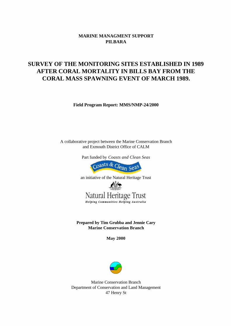
MARINE MANAGMENT SUPPORTPILBARA
SURVEY OF THE MONITORING SITES ESTABLISHED IN 1989AFTER CORAL MORTALITY IN BILLS BAY FROM THE
CORAL MASS SPAWNING EVENT OF MARCH 1989.
Field Program Report: MMS/NMP-24/2000
A collaborative project between the Marine Conservation Branchand Exmouth District Office of CALM
Part funded by Coasts and Clean Seas
an initiative of the Natural Heritage Trust
Prepared by Tim Grubba and Jennie CaryMarine Conservation Branch
May 2000
Marine Conservation BranchDepartment of Conservation and Land Management
47 Henry St
Marine Conservation Branch CALM
T:\Current_MCB_reports\MMS\mms_2400\MMS_2400.doc 05/01/01
ii
Fremantle, Western Australia, 6160
Marine Conservation Branch CALM
T:\Current_MCB_reports\MMS\mms_2400\MMS_2400.doc 05/01/01
III
ACKNOWLEDGMENTS
Direction
Director, Nature Conservation Division, CALM - Keiran McNamaraManager, Marine Conservation Branch, CALM - Dr. Chris Simpson
CALM Regional/District collaboration
Regional Manager, Pilbara Region, CALM - Chris Muller ManagerDistrict Manager, Exmouth District, CALM - Doug MyersMarine Conservation Officer, Exmouth District, CALM - Caroline WilliamsMarine Reserves Officer, Exmouth District, CALM - Adam MeyerRecreation Officer, Exmouth District, CALM - Arvid Hogstron
Project Supervisor - Jennie CaryDive Supervisor/s – Caroline Williams and Adam Meyers
Funding / Resources
This project was part funded by Coasts and Clean Seas an initiative of the Natural Heritage Trust.
This report may be cited as:
Grubba T and Cary J L (May 2000). Survey of the monitoring sites established in 1989 after coralmortality in Bills Bay from the coral mass spawning event of March 1989. Field Program ReportMMS/NMP-24/2000. (Marine Conservation Branch, Department of Conservation and LandManagement, 47 Henry St., Fremantle, Western Australia, 6160). Unpublished report.
Copies of this report may be obtained from:
Marine Conservation BranchDepartment of Conservation and Land Management
47 Henry St.Fremantle, Western Australia, 6160
Ph: (08) 94325100Fx: (08) 94305408
Marine Conservation Branch CALM
T:\Current_MCB_reports\MMS\mms_2400\MMS_2400.doc 05/01/01
IV
Marine Conservation Branch CALM
T:\Current_MCB_reports\MMS\mms_2400\MMS_2400.doc 05/01/01
V
TABLE OF CONTENTS
ACKNOWLEDGMENTS.......................................................................................................................................................III
TABLE OF CONTENTS.........................................................................................................................................................V
1 INTRODUCTION............................................................................................................................................................1
1.1 GENERAL......................................................................................................................................................................11.2 BACKGROUND .............................................................................................................................................................11.3 AIMS .............................................................................................................................................................................2
2 STUDY AREA, METHODS AND EQUIPMENT........................................................................................................6
2.1 STUDY AREA ..............................................................................................................................................................62.2 METHODS ....................................................................................................................................................................62.2.1 Re-survey of Bills Bay sites established in 1989 after coral mortality from the coral mass spawning
event of March 1989........................................................................................................................................62.2.2 Re-locating monitoring sites (transect) eastablsihed as part of NMPMP................................................82.2.3 Re-surveying NMPMP sites in Bundegi to assess the impact of the April 2000 coral bleaching
event ..................................................................................................................................................................92.2.4 Obtaining video imagery of transects..........................................................................................................122.2.5 Contingency for adverse conditions ...........................................................................................................13
2.3 EQUIPMENT ...............................................................................................................................................................142.3.1 Video systems .................................................................................................................................................142.3.2 Still photography ............................................................................................................................................142.3.3 Safety................................................................................................................................................................142.3.4 Information.......................................................................................................................................................142.3.5 Diving ...............................................................................................................................................................152.3.6 Vessels and Vehicles ......................................................................................................................................152.3.7 Position fixing and Communications............................................................................................................152.3.8 Transect establishment..................................................................................................................................162.3.9 Miscellaneous Equipment .............................................................................................................................16
3 FIELD PROGRAMME................................................................................................................................................. 16
3.1 FIELD ITINERARY.....................................................................................................................................................163.2 EQUIPMENT SUPPLIERS AND RELEVANT CONTACTS........................................................................................17
4 SAFETY......................................................................................................................................................................... 17
4.1 EMERGENCY CONTACTS..........................................................................................................................................17
5 BUDGET ........................................................................................................................................................................ 18
6 PUBLICITY/EDUCATION......................................................................................................................................... 18
6.1 PUBLIC RELATIONS OPPORTUNITIES ...................................................................................................................186.2 EDUCATION OPPORTUNITIES ................................................................................................................................19
6 REFERENCES............................................................................................................................................................... 19
7 DISTRIBUTION LIST................................................................................................................................................. 19
APPENDIX I: RESULTS FROM CORAL BAY 1989/1994 SURVEYS...............................................................................20APPENDIX II: BLANK DATA RECORDING SHEETS......................................................................................................21APPENDIX III: UNDERWATER VIDEO SYSTEM ...........................................................................................................29APPENDIX IV: OPERATING THE GARMIN GPS 12XL UNIT ......................................................................................31APPENDIX V: Datasheets for NMPMP permenant transect sites to be re-located ...............................................33Bundegi… ..........................................................................................................................................................................34Bundegi (Re-survey of 1998 survey).............................................................................................................................38
Marine Conservation Branch CALM
T:\Current_MCB_reports\MMS\mms_2400\MMS_2400.doc 05/01/01
VI
Bundegi Sanctuary ...........................................................................................................................................................43Bundegi Sanctuary (Re- survey of 1998 site)...............................................................................................................46Bundegi sanctuary south ................................................................................................................................................52Bundegi North...................................................................................................................................................................56Coral Bay/Billis Bay..........................................................................................................................................................61Coral Bay North.................................................................................................................................................................65Bills Bay North ..................................................................................................................................................................69Bills Bay South..................................................................................................................................................................73Bills Bay West...................................................................................................................................................................77Bills Bay East.....................................................................................................................................................................81Monks Head ......................................................................................................................................................................85
LIST OF FIGURES
Figure 1. Location map of Ningaloo Marine Park and proposed southern extension..............................................3Figure 2. Location map of monitoring sites established in Bills Bay in March1989 .................................................4Figure 3. Location map of permanent long-term monitoring transect sites established in the Bundegi and BillsBay areas during the Ningaloo Marine Park monitoring program...............................................................................5
LIST OF TABLES
Table 1. Field itinerary for the period 12 May to 22 May 2000...................................................................................16Table 2. Budget reconciliation for the Coral Bay 2000 Field Trip ..............................................................................18
Marine Conservation Branch CALM
T:\Current_MCB_reports\MMS\mms_2400\MMS_2400.doc 05/01/01
1
1 INTRODUCTION
1.1 GENERAL
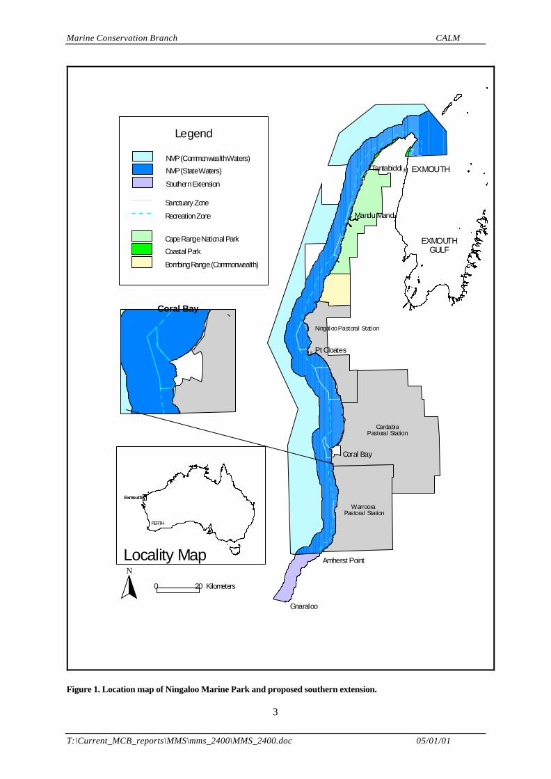
This field program report presents information on the May 2000 field survey to be undertaken in theBills Bay and Bundegi areas, located in the Ningaloo Marine Park (Figure 1).
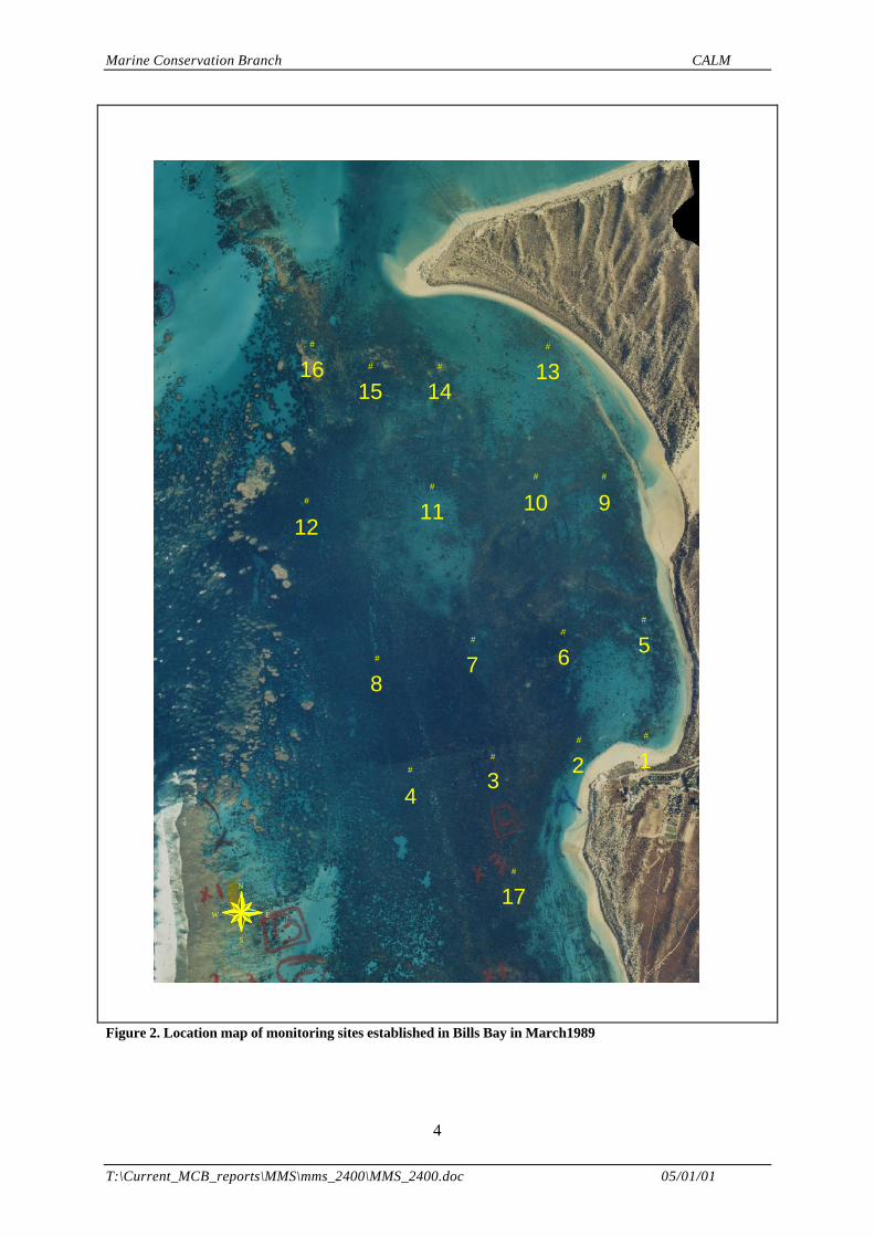
The primary objective is to re-survey 17 monitoring sites established in Bills Bay (off Coral Bay) in1989 and re-surveyed in 1994 (Figure 2). The survey will provide information on the level of coralrecovery in the ten years since coral spawn slicks caused mass mortality of corals in the bay duringMarch 1989.
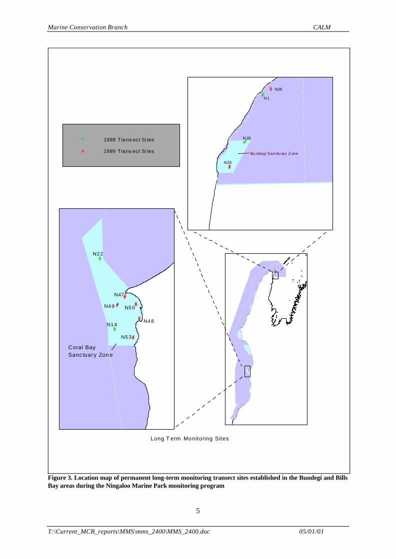
A secondary objective is to validate the re-locatability of monitoring sites established in 1998/99 in BillsBay and Bundegi as part of the Ningaloo Marine Park Monitoring Program (NMPMP) to assist inplanning future field trips (Figure 3). These sites were originally positioned with a DGPS, whoseaccuracy is specified at ± 1 m. This proposed exercise will ascertain the ease with which these sitescan be relocated with a DGPS, given the original recordings.
If time is available a third objective will be to re-survey monitoring sites established in the Bundegi areaas part of the NMPMP in 1998/99 in order to document a recent coral bleaching event (Figure 3).
The field survey will be coordinated by the Marine Conservation Branch (MCB) of CALM (ProjectSupervisor: Jennie Cary) in collaboration with the Exmouth District of CALM (Contact: Doug Myers).
The Project Supervisor (Jennie Cary) will also have the role of MCB Field Team Leader and willcoordinate all activities in the field.
Caroline Williams and Adam Meyer will supervise all diving activities in the field, and will both bedesignated Dive Supervisors.
Other CALM staff will include Chris Simpson and Tim Grubba from the MCB and Arvid Hogstronfrom the Exmouth District Office.
1.2 BACKGROUND
MASS MORTALITY OF CORALS WITHIN BILLS BAY DUE TO CORAL SPAWN SLICKS IN MARCH 1989
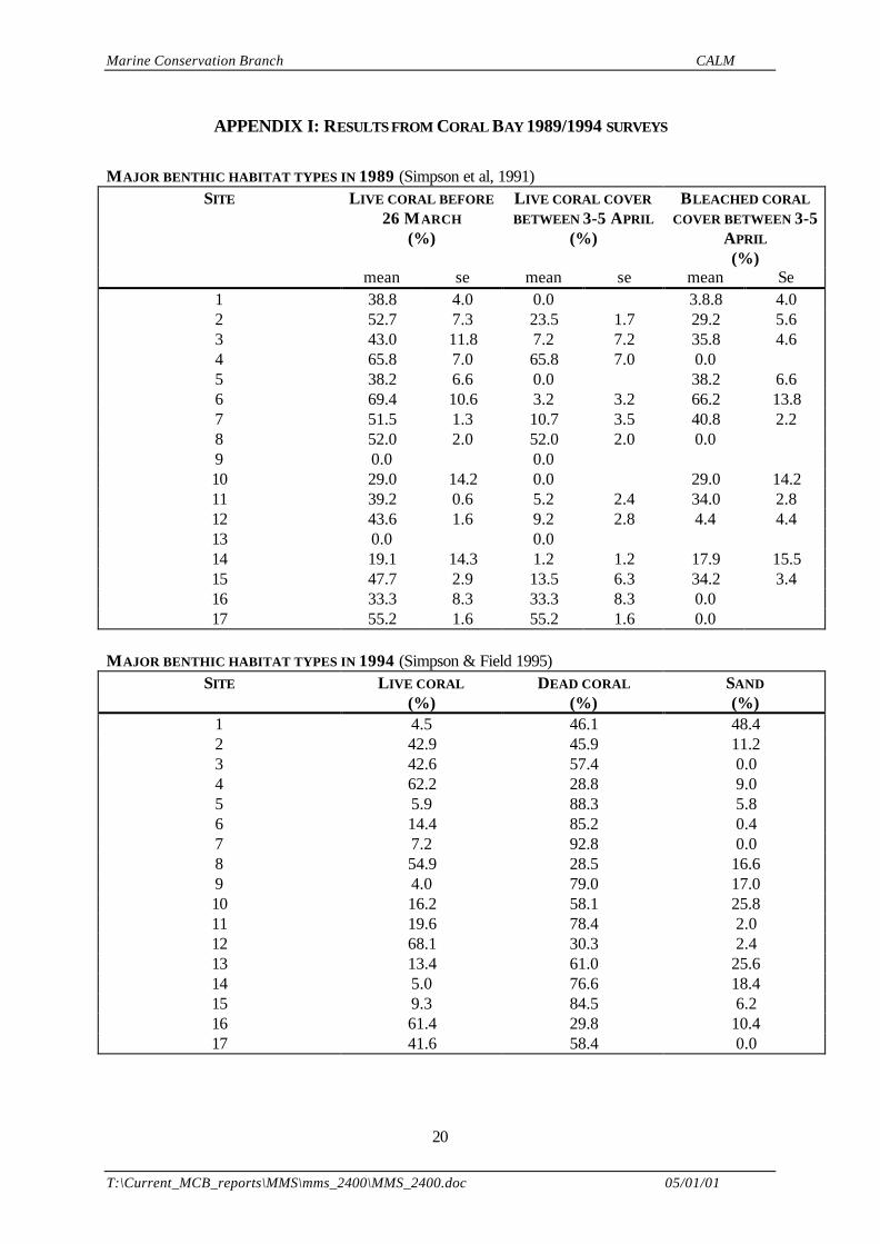
In March 1989 the majority of the corals in Bills Bay, off the north-western coastline of Australia,spawned several nights earlier than usual. Flood, rather than ebb, tides at the time of spawningcombined with light north-west winds and low swell conditions to restrict the dispersal of coralpropagules and, as a result, large amounts of coral spawn were trapped in the bay forming extensiveslicks. Fish and other animals began to die almost immediately and, over the following few days, overone million fish consisting of at least 80 species were washed ashore. A survey of the benthiccommunities revealed extensive mortality of corals and other reef animals over an area of about threesquare kilometres. Live coral cover in this area decreased from 42.9% to 9.4% and several large coralcolonies up to 10 meters in diameter were killed (Appendix I). The observed mortality was believed tobe the result of hypoxia (oxygen depletion) created initially by the respiratory demand of the coralspawn and maintained by the biological oxygen demand of the decomposing spawn slicks and deadanimals (Simpson et al 1991).
Anecdotal reports of corals and other reef animals dying in the vicinity of coral spawn slicks on otherreefs in Western Australia suggest that this phenomenon may be a relatively common event on shallow
Marine Conservation Branch CALM
T:\Current_MCB_reports\MMS\mms_2400\MMS_2400.doc 05/01/01
2
coral reefs where coral mass spawning occurs (Simpson et al 1991). These records and observationsdocument, for the first time, a new source of natural disturbance that has a significant influence on thecommunity structure of some coral reefs.
THE NINGALOO MARINE PARK MONITORING PROGRAM (NMPMP)
The aim of the Ningaloo Marine Park Monitoring Program (NMPMP) is to assess the ‘health’ ofmajor benthic habitats of the marine park and proposed southern extension. Long term monitoring siteswere established in 1998 and 1999 to provide baseline ecological data from which the impacts fromhuman activities can be monitored and managed to ensure that all activities are ecologicallysustainable.
Two previous field surveys have been conducted by CALM in collaboration with the AustralianInstitute of Marine Science (AIMS) as part of the NMPMP (Cary and Grubba, 1998 and Cary et al.1999).• In May 1998 twenty-one long term monitoring sites (all permanent transects) were established
approximately every 15 kms along the back-reef of the marine park and proposed southernextension
• In August 1999 thirty long term monitoring sites (of which nine are permanent transects) wereestablished in areas of high human usage
CORAL BLEACHING
The Exmouth District Office of CALM observed coral bleaching in Exmouth Gulf in April 2000 duringaerial reconnaissance. Bleaching was observed in the following areas:1. Bundegi;2. western side of reef at Serrurier Island Nature Reserve;3. western side of Y Island Nature Reserve;4. western side of Burnside Island Nature Reserve and5. western side of Simpson Island Nature Reserve
1.3 AIMS
PRIMARY AIM
• to re-survey 17 monitoring sites established in Bills Bay (off Coral Bay) in 1989 and re-surveyed in1994 (Figure 2). The survey will provide information on the level of coral recovery in the ten yearssince coral spawn slicks caused mass mortality of corals in the bay during March 1989.
SECONDARY AIMS
• to validate the re-locatability of monitoring sites established in 1998/99 in Bills Bay and Bundegi aspart of the Ningaloo Marine Park Monitoring Program (NMPMP) to assist in planning futurefield trips (Figure 3). These sites were originally positioned with a DGPS , whose accuracy isspecified at ± 1 m. This proposed exercise will ascertain the ease with which these sites can berelocated with a DGPS, given the original recordings
• If time is available re-survey monitoring sites established in the Bundegi area as part of theNMPMP in 1998/99 in order to document a recent coral bleaching event (Figure 3).
Marine Conservation Branch CALM
T:\Current_MCB_reports\MMS\mms_2400\MMS_2400.doc 05/01/01
3
#
#
EXMOUTHTantabiddi
Pt Cloates#
Coral Bay
Amherst Point#
Gnaraloo
#
# Mandu Mandu
EXMOUTHGULF
NingalooPastoral Station
CardabiaPastoral Station
WarrooraPastoral Station
0 20 Kilometers
Locality Map
# PERTH
#Exmouth
SanctuaryZone
RecreationZone
NMP(CommonwealthWaters)
NMP(StateWaters)
SouthernExtension
CapeRangeNational Park
Coastal Park
BombingRange(Commonwealth)
Legend
N
Coral Bay
Figure 1. Location map of Ningaloo Marine Park and proposed southern extension.
Marine Conservation Branch CALM
T:\Current_MCB_reports\MMS\mms_2400\MMS_2400.doc 05/01/01
4
#
##
#
###
#
#
##
#
##
#
#
#
131415
16
9101112
5678
123
4
17N
EW
S
Figure 2. Location map of monitoring sites established in Bills Bay in March1989
Marine Conservation Branch CALM
T:\Current_MCB_reports\MMS\mms_2400\MMS_2400.doc 05/01/01
5
####
####
########
####
####
####
#
Coral BaySanc tuary Zon e
N47
N4 8
N5 0
N5 3
N1 4
N2 2
N4 9
1999 Tra ns ect Si tes
1998 Tra ns ect Si tes#
#
####
#######
####
# Bu ndegi Sanctu ary Zone
N26
N29
N 1
N 19
Long T erm Monitoring Sites
Figure 3. Location map of permanent long-term monitoring transect sites established in the Bundegi and BillsBay areas during the Ningaloo Marine Park monitoring program
Marine Conservation Branch CALM
T:\Current_MCB_reports\MMS\mms_2400\MMS_2400.doc 05/01/01
6
2 STUDY AREA, METHODS AND EQUIPMENT
2.1 STUDY AREA
The Ningaloo Reef, is a fringing-barrier coral reef enclosing a shallow lagoon that extends for about280 kilometres along the west coast of Australia between latitudes 21º 47’ - 24º S (Figure 1). Thewidth of the lagoon ranges from 0.5 to 6 kilometres (average 2.5 kilometres) and has a mean depth atAHD of about 2 metres (Hearn et al., 1986). In 1987 the Ningaloo Marine Park (State waters) wasgazetted as Marine Park Reserve No. 2 (Figure 1).
Two areas of the Ningaloo Marine Park will be visited during the May 2000 field trip including theBundegi and Bills Bay areas.
BUNDEGI AREA
The Bundegi area is situated in the northern part of the marine park on the eastern shores of the NorthWest Cape in the Exmouth Gulf. The Bundegi area is not typical of the reef structure found throughoutthe majority of the marine park. There is a near shore reef with poorly defined lagoon that is exposedto the Exmouth Gulf waters which have a high sediment load. The Bundegi area was impacted in April1999 by Cyclone Vance which crossed the coast in the Bundegi area. In mid April 2000 the areaexperienced some coral bleaching.
BILLS BAY AREA
The Bills Bay area is situated in the lower half of the marine park adjacent to the Coral Baysettlement. Bills Bay is typical of the Ningaloo reef with a fringing-barrier reef, enclosing a shallowlagoon (average water depth 3 metres) that is between 2 –2.5 kilometres wide. The majority of thelagoon is zoned as a sanctuary zone (Figure 3). The area has been a marine reserve for the past 20years and, as such, as been largely unaffected by human activities. A significant percentage of coralswithin the bay were killed as a result of the coral spawn slick in March 1989.
2.2 METHODS
2.2.1 Re-survey of Bills Bay sites established in 1989 after coral mortality from the coralmass spawning event of March 1989
The seventeen monitoring sites established in Bills Bay lagoon in 1989 will be re-surveyed (Figure 2).The sites were established near prominent seabed features identified from an aerial photograph of BillsBay. The site locations were recorded on a line diagram (Figure 2). The line diagram was enlarged(~120 %) to fit over an aerial photograph produced by the Department of Marine and Harbours WA(Coral Bay DMH 612, 1991), as the original aerial photograph could not be located. Each site iscomprised of three 50 m transects laid in an east – west orientation. The transects will laid parallel toeach other with a 20 m spacing between each transect. The sites will be re-surveyed using thetransect video sampling method (Christie et al. 1996).
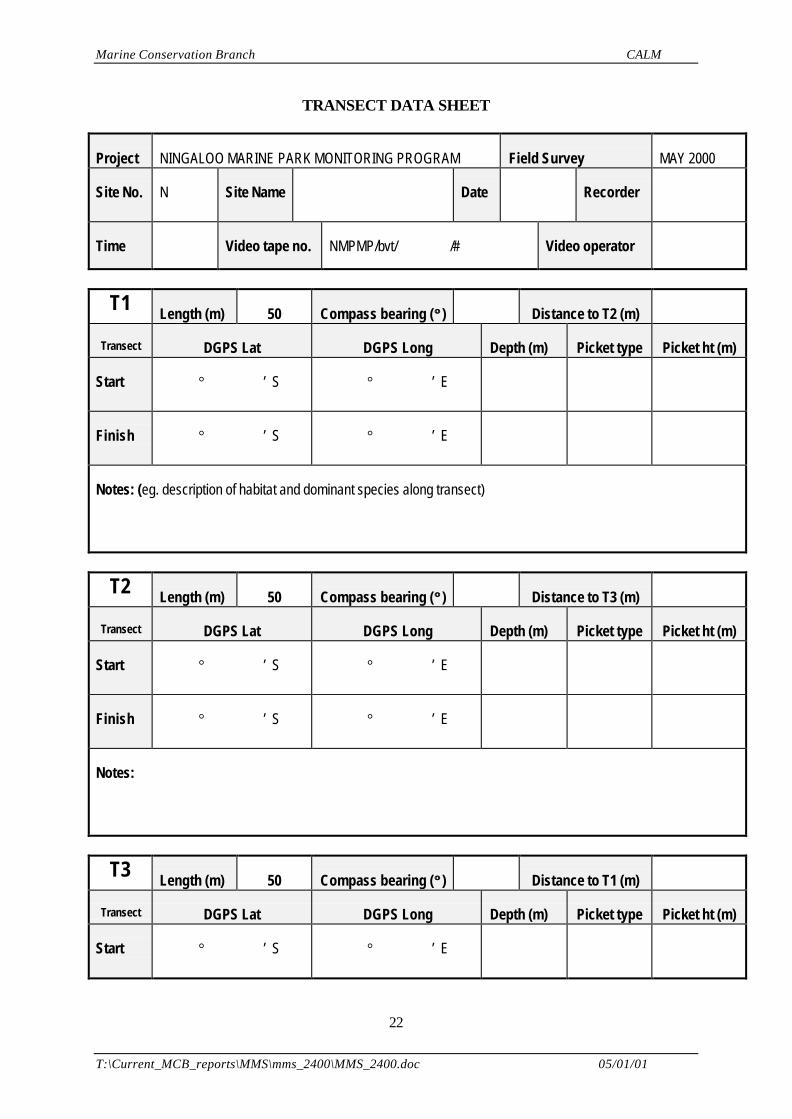
All habitat data and related observations will be recorded electronically onto standard data files, whichhave been pre-formatted and stored on a laptop computer. Data sheets for written data recordings willalso be made available. All written data is to be transferred to the computer files during the fieldsurvey, and preferably on the day of collection. Examples of data recording sheets are presented inAppendix II.
FIELD PROCEDURES
This procedure has been approved by the Departmental Diving Officer (Alan Byrne)
Marine Conservation Branch CALM
T:\Current_MCB_reports\MMS\mms_2400\MMS_2400.doc 05/01/01
7
The following outlines the field procedures to be used when re-surveying the Bills Bay sites. Theprocedures are based on using one boat with a crew of four. An additional boat is available and can beused if required. The roles of each crew member include:• BOAT OPERATOR: Operates the boat• SNORKELLER: works with the boat operator in supporting the divers in the water and assisting in
DGPS recordings (ie. holds boat over the site while DGPS coordinates are determined)• DIVER 1: operates the video camera• DIVER 2: records data
1. Locate the position of the site in the boat using GPS coordinates and the pre-marked aerialphotograph
2. Mark the site position using a weighted marker buoy (see 4.1 or 5.1) 3. The site is then viewed using a viewfinder or a snorkel diver to confirm the site.
4. If conditions are calm with low current and relatively flat bathymetry, the three 50m transect linescan be deployed and retrieved by boat rather than divers
4.1. The end of transect two is clipped to the weight of a marker buoy
4.2. Transect two is deployed while driving the boat in a straight line along a pre-determined
compass bearing (west to east)
4.3. When transect two has been deployed the start of the transect is clipped to the weight of amarker buoy
4.4. The start of the transect one is clipped to the weight of a marker buoy. The transect isdeployed in a straight line (west to east) 20m to the north and parallel to transect two
4.5. When transect one has been deployed the transect end is clipped to the weight of amarker buoy
4.6. The start of the transect three is clipped to the weight of a marker buoy. The transect isdeployed in a straight line (west to east) 20m to the south and parallel to the transect two
4.7. When transect three has been deployed the transect end is clipped to the weight of amarker buoy
4.8. Once the three transects have been deployed, a visual check should be carried out toensure that the transects were laid straight and parallel. The visual check can be made eitherfrom the boat or by a snorkeller. If necessary the transect line should be adjusted by thesnorkeller or SCUBA divers
5. If conditions are adverse with strong winds, currents and/or irregular bathymetry, the three 50m
transect lines should be deployed using divers
6. The two divers are deployed at the start of transect one (west end) and the boat stands by (clearof the divers) and waits for the two divers to film transect one
Marine Conservation Branch CALM
T:\Current_MCB_reports\MMS\mms_2400\MMS_2400.doc 05/01/01
8
7. One diver has the role of video camera operator and the second diver is a data recorder(Appendix III)
8. The camera operator films the area adjacent to the start of transect. Anything that is ofsignificance is also filmed. The site and transect details inscribed on an underwater slate arefilmed. The diver then films along the transect line (Section 2.2.4)
9. The data recorder diver follows the video operator who is filming the transect. This diver isrecording general observations such as dominant species, general health and any visible impactsetc. This diver will also draw mud-maps of the position of the transect in relation to prominentfeatures to assist in future relocation (Appendix II)
10. The divers will signal the boat that they have completed the first transect and will move on to thestart of transect two (east end) and carry out steps 8 and 9
11. The boat operator and snorkeller will record the DGPS coordinates of transect one (marker buoys)(Appendix IV)
12. The divers will signal the boat that they have completed transect two and will move on to the startof transect three (west end) and carry out steps 8 and 9
13. The boat operator and snorkeller will record the DGPS coordinates of transect two (markerbuoys) (Appendix IV)
14. When the divers signal that they have completed transect three the boat retrieves the divers andrecords the DGPS coordinates of transect three (marker buoys)
15. The boat then retrieves the transect lines and weighted marker floats. In the event of a line
becoming snagged the snorkeller enters the water to unsnag the line
16. The boat then moves to the next site or returns to the boat ramp
2.2.2 Re-locating monitoring sites (transect) established as part of NMPMP
A number of permanent transects established in 1998/99 in Bills Bay and Bundegi will be re-located inMay 2000 (Figure 1). The exact number of sites will depend on the amount of time available. The timetaken to re-locate each site will be recorded and will assist in the planning of future field trips.
FIELD PROCEDURES
This procedure has been approved by the Departmental Diving Officer (Alan Byrne)
The following outlines the field procedures to be used when re-locating the Bills Bay and Bundegisites. The procedures are based on using one boat with a crew of four. An additional boat is availableand can be used if required. The roles of each crew member include:
• BOAT OPERATOR: Operates the boat• 1-3 SNORKELLERS: one snorkeller assists the boat operator with DGPS recordings (holds boat over
site while DGPS coordinates being determined) and the other snorkellers assist in site location
Marine Conservation Branch CALM
T:\Current_MCB_reports\MMS\mms_2400\MMS_2400.doc 05/01/01
9
1. From the boat use the Garmin GPS unit to locate the general site position using the 1998/1999DGPS coordinates (the start of the first transect) (Appendix IV). Pre-marked aerial photographsand site descriptions (eg. mud maps) will also be referred to
2. After the general location has been reached refine the search using the DGPS unit
3. Once the coordinates (1998/1999) of the site have been reached, the position should be markedusing a weighted marker buoy
4. Snorkellers equipped with four weighted marker buoys enter the water to determine whether thefirst deployed marker buoy marks the position of the star picket which defines the start of the firsttransect
5. If the star picket can not been seen, then the snorkellers should begin a coordinated search of thesurrounding area by searching in an expanding circular pattern from the deployed marker buoy
6. Once snorkellers have found a star picket they should mark its location with a weighted markerbuoy
7. When a star picket is found the snorkeller should determine which star picket they have found byreading the transect details inscribed on the pvc cap (if the pvc cap is still present and inscription isstill legible). This information can orient the snorkeller in regards to the position of the remainingstar pickets (remembering there are three transects, laid end to end, in a north south orientation)
8. Once all the star pickets have been found and marked the snorkellers should return to the boat
9. If star pickets are missing pvc caps and the details of the star picket are known (eg. N14 T3) thenwhere possible a new pvc cap should be installed. The boat operator should inscribe the relevantdetails onto the pvc cap and the snorkeller should wire the cap into place
10. If the site is in the Bundegi area then the transects will be surveyed using the video transectmethod (Refer to sections 2.2.3 and 2.2.4)
11. With a snorkeller positioning the boat/DGPS antennae over the star picket re-record the DGPScoordinates using the datum WGS84. Repeat this process for all the star pickets (Appendix IV)
12. If there is time and the site was located far from the original DGPS coordinates then it is worthexperimenting with the DGPS unit by changing the datum from WGS84 to another possible datum(eg. AGD 84, or North American Datum) to check if the original coordinates were in that datum
13. The boat then retrieves the weighted marker floats. In the event of a line becoming snagged a
snorkeller enters the water to unsnag the line
14. The boat then moves to the next site or returns to the boat ramp
2.2.3 Re-surveying NMPMP sites in Bundegi to assess the impact of the April 2000 coralbleaching event
If there is time, the NMPMP permanent transect sites at Bundegi will be surveyed using the transectvideo method as per previous NMPMP surveys. The Bundegi sites are to be surveyed in order todocument recent coral bleaching events in the area reported by the CALM Exmouth office.
Marine Conservation Branch CALM
T:\Current_MCB_reports\MMS\mms_2400\MMS_2400.doc 05/01/01
10
All habitat data and related observations will be recorded electronically onto standard data files, whichhave been pre-formatted and stored on a laptop computer. Data sheets for written data recordings willalso be made available. All written data is to be transferred to the computer files during the fieldsurvey, and preferably on the day of collection. Examples of data recording sheets are presented inAppendix II.
FIELD PROCEDURES
This procedure has been approved by the Departmental Diving Officer (Alan Byrne)
The following outlines the field procedures to be used to re-survey Bundegi sites. The procedures arebased on using one boat with a crew of four. An additional boat is available and can be used ifrequired. The roles of each crew member include:
• BOAT OPERATOR: Operates the boat• SNORKELLER: works with the boat operator in supporting the divers in the water and assisting in
DGPS recordings (holds boat over site while DGPS coordinates being determined)• DIVER 1: operates the video camera• DIVER 2: records data
1. Refer to section 2.2.2 for procedures on site relocation
2. If conditions are calm with low current and relatively flat bathymetry, the three 50m transect linescan be deployed and retrieved by boat rather than divers
2.1. The start of the first transect line is clipped to the weight of the first marker buoy
2.2. The first transect line is deployed while driving the boat in a straight line along a pre-determined compass bearing towards the second marker buoy
2.3. When the first 50m transect line has been deployed the transect end is clipped to theweight of the second marker buoy
2.4. The start of the of the second transect line is also clipped to the weight of the secondmarker buoy which is then re-deployed
2.5. The second transect line is deployed as per 2.2
2.6. When the second 50m transect line has been deployed the transect end is clipped to theweight of the third marker buoy
2.7. The start of the of the third transect line is also clipped to the weight of the third markerbuoy which is then re-deployed
2.8. The third transect line is deployed as per 2.2 and 2.5
2.9. When the third 50m transect line has been deployed the transect end is clipped to theweight of the fourth marker buoy which is then re-deployed
Marine Conservation Branch CALM
T:\Current_MCB_reports\MMS\mms_2400\MMS_2400.doc 05/01/01
11
2.10. Once the three transects have been deployed, a visual check should be carried out toensure that the transects were laid straight. The visual check can be made either from theboat or by a snorkeller. If necessary the transect line should be straightened by the snorkelleror SCUBA divers
3. If conditions are adverse with strong winds, currents and/or irregular bathymetry, the three 50mtransect lines should be deployed using divers
3.1. The start of the first transect line is clipped to the first weighted marker buoy or starpicket
3.2. The first transect line is deployed by a diver swimming along a pre-determined compasscourse (north to south) while unrolling the transect from it’s reel.
3.3. When the first transect has been laid the transect end is clipped to the weight of thesecond marker buoy or star picket
3.4. The start of the second transect line is also clipped to the weight of the second markerbuoy or star picket
3.5. The second transect line is deployed as per 5.2
3.6. When the second transect line has been deployed the transect end is clipped to the weightof the third marker buoy or star picket
3.7. The start of the third transect line is also clipped to the weight of the third marker buoy orstar picket
3.8. When the third transect line has been deployed the transect end is clipped to the weight ofthe fourth marker buoy or star picket
4. The two divers are deployed and the boat stands by (clear of the divers) and waits for the twodivers to film the first transect
5. One diver has the role of video camera operator and the second diver is a data recorder(Appendix III)
6. The camera operator films the area adjacent to the start of first transect. Anything that is ofsignificance is also filmed. The site and transect details inscribed on an underwater slate arefilmed. The diver then proceeds filming along the transect line (Section 2.2.4)
7. The data recorder diver follows the video operator who is filming the transect. This diver isrecording general observations such as dominant species, general health and any visible impactsetc. This diver will also draw mud-maps of the position of the transect in relation to prominentfeatures to assist in future relocation (Appendix II)
8. The divers will signal the boat that they have completed the first transect and will move on to thesecond transect as per 6 and 7
9. The boat operator and snorkeller will record the DGPS coordinates of the start of the first transect(marker buoy) followed by the start of the second transect (Appendix IV)
Marine Conservation Branch CALM
T:\Current_MCB_reports\MMS\mms_2400\MMS_2400.doc 05/01/01
12
10. The divers will signal the boat that they have completed the second transect and will move on tothe third transect as per 6 and 7
11. When the divers signal that they have completed the third transect the boat retrieves the diversand records the DGPS coordinates of the end of the second transect (marker buoy) and thirdtransect
12. The boat then retrieves the transect lines and weighted marker floats. In the event of a linebecoming snagged the snorkeller enters the water to unsnag the line
13. The boat then moves to the next site or returns to the boat ramp
2.2.4 Obtaining video imagery of transectsThe transect sampling technique is adapted from the AIMS Standard Operating Procedure No. 2(Christie et al., 1996). The recording of data for each transect should be carried out according to thefollowing steps:
1 Fill out the details on the in-water data sheet (positioned on the top of the housing) identifying thetransect. Record the site number, date, transect number, and recorder’s name
2 Before beginning to film the transect, record a panoramic shot of the area adjacent to the start of
the transect (for instructions on the setup and use of the video see Appendix IV). At the start ofthe transect, hold the camera in a horizontal position and turn slowly clockwise, filming theimmediate surroundings and ending at the initial view. Video the underwater slate to record thesite number and transect number written on the underwater slate
3 Record the start time code on the data sheet. Press REC and film the start of the transect tape
for a few seconds and then move along the tape or scaled rope, keeping it approximately 10 cm infrom the right hand side of the field of view. Keep the housing lens parallel to the substrate at adistance of 50 cm
4 Follow the transect line keeping the housing at the set height of 50 cm, ensuring that the screen
image is in focus. Adjust your swimming speed so that it is constant and you cover approximately10 m every minute, and not faster. This is important to ensure a high quality of image. Each 25mtransect should take between 2 ½ and 3 minutes in total or each 50m transect between 5 and 6minutes in total. At the end of the transect video the end of the transect for a few seconds andthen press STBY
5 Record the finish time code on the data sheet 6 If filming of a transect has to be aborted for any reason, or if there is considerable variation in the
height or speed of the recorder, then the entire transect should be re-sampled, beginning againfrom the start point of the transect. It is important that the new start and finish time codes for anyrepeated transects are clearly recorded on the data sheets
7 Proceed to the next transect. Once all transects at a site have been completed and the tape has
been viewed and checked, full details must be recorded on the main video transect data sheet(Appendix II). Any repeated or incomplete transects, or situations where transects were filmedout of order or with false starts should be noted on the data sheets
Marine Conservation Branch CALM
T:\Current_MCB_reports\MMS\mms_2400\MMS_2400.doc 05/01/01
13
8 A total of four sites should be recorded on each 60min digital video tape. The tape and tape covershould be clearly labelled (using a permanent marker) with the designated tape number (AppendixIII), the site number and date of recording. The copy protect switch on the tape should beswitched from REC to SAVE to prevent accidental recording over any data, and the tapes shouldbe stored in a waterproof case at all times
9 At the end of the field trip and before data analysis the tapes must be duplicated, in digital format,
and the originals archived and stored separately from the duplicates
2.2.5 Contingency for adverse conditionsIn the event of adverse weather, sea or road (track) conditions the Field Team Leader in consultationwith the boat skipper may choose to re-evaluate the day’s field programme and change the schedule ifnecessary. This would primarily involve the abandonment of a site at which conditions are unsuitableand the replacement of the site with a site that is sheltered from the wind and/or offers better seaconditions for underwater work, and/or is accessible by road.
Marine Conservation Branch CALM
T:\Current_MCB_reports\MMS\mms_2400\MMS_2400.doc 05/01/01
14
2.3 EQUIPMENT
2.3.1 Video systemsPrimary• Canon MV1 digital video camera with battery packs (4) and chargers (2)• Amphibico underwater video housing• Housing O-ring kit and silicone grease• Cleaning kit• Video transect data sheets• Instruction manuals• TV/video unit• Digital video tapes (15)• Leads, remote control, sparesBackup• Canon MV1 digital video camera• Amphibico underwater video housing• Housing O-ring kit and silicone grease• Cleaning kit• Instruction manuals• Leads, remote control, spares
2.3.2 Still photography• Camera 1: Nikonos V, 35mm lens, 15mm lens, SB102 strobe unit and close up kit• Land Camera• 5 rolls of 36 exposure print film• 5 rolls of 36 exposure slide film• Log books for cameras• Kit of camera spares
2.3.3 Safety• Comprehensive diving first aid kit• Emergency response flowsheet• Emergency contact flow chart• Patient information log• Accident log sheets• Oxy-viva units (1)• Spare oxygen D cylinder and regulator• 4 wet weather jackets• Sunscreen• Spare sunglasses• Vinegar and flask hot water per vessel
2.3.4 Information• Marine Charts: Satellite photos, coastal maps, sanctuary zone maps with latitudes and longitudes• Reference books for the identification of corals, fish, birds, marine mammals and marine fauna• Scientific reference file• Full set of aerial photographs of Ningaloo Marine Park• Laminated scanned copies of aerial photographs of the sites for field use• Habitat data sheets• Long-term monitoring site data sheets
Marine Conservation Branch CALM
T:\Current_MCB_reports\MMS\mms_2400\MMS_2400.doc 05/01/01
15
• Transect data sheets• Video data sheets• 1 laptop computer plus 10 floppy discs• 4 field notebooks• 1 box of pencils• 1 stationary box• equipment log book
2.3.5 Diving• Personal dive gear• 8 scuba tanks• 3 BCD’s• 3 regulators with alternate airsource and gauges• 2 masks and snorkels• 2 spare pairs of fins• 3 dive computers• 2 spare weight belts, each with 24 lb of weight• 3 compasses• 2 boat dive flags• 1 personal dive flag• 2 dive spare parts and repair kits• 4 pocket size underwater slates, grips and pencils• 1 large underwater slates, grips and pencils• 1 catch bags• 100 sheets underwater paper• box graphite sticks• box elastic bands• printed underwater paper for recording video codes• 1 viewfinder• Scuba log book
2.3.6 Vessels and Vehicles• CALM MCB 12’6” zodiac (C401)with all safety equipment for survey exempt vessel, fitted with
35hp Yamaha outboard. Two 20-litre containers for fuel• Additional boat (Quintrex- Aluminium with 40hp outboard or 3.7 m Quicksliver inflatable with 15
hp outboard)• Bags, repair kit, ropes, oars and lines, and fuel tanks• MCB Mitsubishi Triton 4x4• MCB heavy duty trailer with spare wheel, outboard rack and roof racks for inflated zodiac• CALM Exmouth vehicle• Vehicles to have full tool kit, battery jumper leads, tyre inflator coupled to scuba cylinder valve
2.3.7 Position fixing and Communications• 1 hand held GPS unit• 1 hand held GPS units and accessories (DGPS)• 1 Omni star differential GPS unit, antennae and accessories• 1 calm hand-held radio and charger• 1 waterproof bag for radios• CALM vehicle equipped with CALM VHF
Marine Conservation Branch CALM
T:\Current_MCB_reports\MMS\mms_2400\MMS_2400.doc 05/01/01
16
2.3.8 Transect establishment• 9x pre cut marker buoys (6 x 5m, 3 x 10m)• 3 x 50m weighted transect lines, marked at 10cm increments• 5 x 600mm galvanised steel pickets• 5 x 1800mm galvanised steel pickets• 10 x 600m PVC caps for pickets• 20 x 250mm stainless steel for fixing caps• 3 x permanent markers for marking caps• 1 x 15lb sledge hammers• 1 x picket drivers• 1 x driver extensions• 10 x 8lb weights
2.3.9 Miscellaneous Equipment• Comprehensive mechanical tool kit• Comprehensive electrical repair kit• 10 AA batteries• 10 D batteries• 10 C batteries• 2 motorbike batteries and chargers• 1 x MCB esky
3 FIELD PROGRAMME
3.1 FIELD ITINERARY
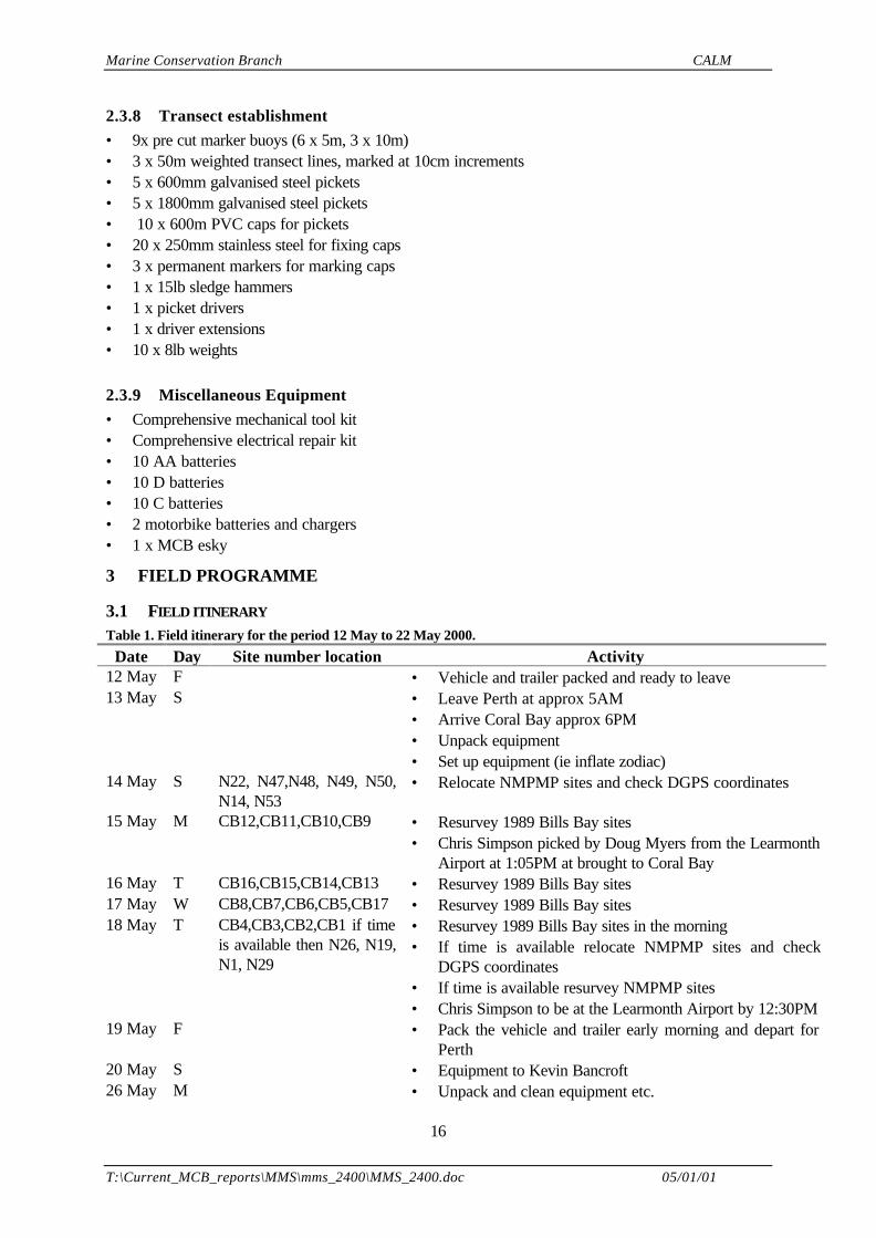
Table 1. Field itinerary for the period 12 May to 22 May 2000.
Date Day Site number location Activity12 May F • Vehicle and trailer packed and ready to leave13 May S • Leave Perth at approx 5AM
• Arrive Coral Bay approx 6PM• Unpack equipment• Set up equipment (ie inflate zodiac)
14 May S N22, N47,N48, N49, N50,N14, N53
• Relocate NMPMP sites and check DGPS coordinates
15 May M CB12,CB11,CB10,CB9 • Resurvey 1989 Bills Bay sites• Chris Simpson picked by Doug Myers from the Learmonth
Airport at 1:05PM at brought to Coral Bay16 May T CB16,CB15,CB14,CB13 • Resurvey 1989 Bills Bay sites17 May W CB8,CB7,CB6,CB5,CB17 • Resurvey 1989 Bills Bay sites18 May T CB4,CB3,CB2,CB1 if time
is available then N26, N19,N1, N29
• Resurvey 1989 Bills Bay sites in the morning• If time is available relocate NMPMP sites and check
DGPS coordinates• If time is available resurvey NMPMP sites• Chris Simpson to be at the Learmonth Airport by 12:30PM
19 May F • Pack the vehicle and trailer early morning and depart forPerth
20 May S • Equipment to Kevin Bancroft26 May M • Unpack and clean equipment etc.
Marine Conservation Branch CALM
T:\Current_MCB_reports\MMS\mms_2400\MMS_2400.doc 05/01/01
17
3.2 EQUIPMENT SUPPLIERS AND RELEVANT CONTACTS
The following list gives contact details of the suppliers of major items of equipment.
Aerial photos: DOLA, Alan Warton, Ph. 92737166Ansett: Flights, Ph. 131644Calm, Exmouth: Ph. (08) 99 491676 (fax) (08) 99 491580Transport: Cape Transport (Mick & Jane Stamp, or Shane) Ph. 08 99491041Exmouth automotive and marine Alan Waddingham; (08) 99492795John Houghton (Courier Service Exmouth to Mildura via Coral Bay): 08 99491020Omnistar differential GPS: Fugro Pty Ltd, Gary Allen, Ph. 93225295PVC picket extensions : Swan Irrigation, Steve Carrie, Ph 9446 9966Underwater video system: Sea Optics, David Hill, Ph. 08 3626161Zodiac inflatable vessel: Wiltrading, Geoff Jordan, Ph. 3359155Exmouth Tourist Bureau: (08) 9 949 1176
4 SAFETY
Safety issues relating to:• field work are the responsibility of the Field Team Leader, Jennie Cary• diving are the responsibility of the Diving Supervisor, Caroline Williams• boating and navigation are the responsibility of the boat skipper (rotation of suitably qualified team
members)
4.1 EMERGENCY CONTACTS
There will be daily contact with the Exmouth District Office of CALM via the Mobile Ranger (BruceBond) stationed at Coral Bay. Contact with the field team should be made through the ExmouthDistrict Office of CALM.
GeneralCALM, Exmouth: Ph.(08) 9 949 1676 and (08) 9 949 2113, Fax (08) 9 949 1580CALM, Marine Conservation Branch, Fremantle: Ph (08) 9 432 5100; Fax (08) 9 430 5408Fisheries Department, Exmouth: Ph (08) 9 949 2755Coral Bay Nursing Post: Ph. (08) 9 942 5828 (Maureen Woodhams private Ph. (08) 9 942 5825)Exmouth Dive Centre: Coral Bay Ph (08) 9 942 5824; Exmouth Ph (08) 9 949 1201Exmouth Hospital/Ambulance: Ph.(08) 9 949 1011, fax (08) 9 949 1017Exmouth Police: Ph. (08) 9 949 2444Fremantle Hyperbaric/Diving Service: (08) 9 431 2233 or (08) 9 431 3333Royal Flying Doctor Service: Admin., Ph (08) 9 414 1200Coral Bay Volunteer Rescue Group: Ph. (08) 9 942 5933 , Call Sign: VMR679, Channel 90(UHF,VHF)Exmouth Sea Rescue Group: Ph. (08) 9 949 2382, Call Sign: VMR682, Channel 90 (UHF, VHF)
RadioCALM VHF Radio: Monitored at Exmouth office, use channel 11 (north of Yardie Creek) andchannel 17 (south of Yardie Creek)Marine VHF: A hand held unit will be carried on vessels
Marine Conservation Branch CALM
T:\Current_MCB_reports\MMS\mms_2400\MMS_2400.doc 05/01/01
18
5 BUDGET
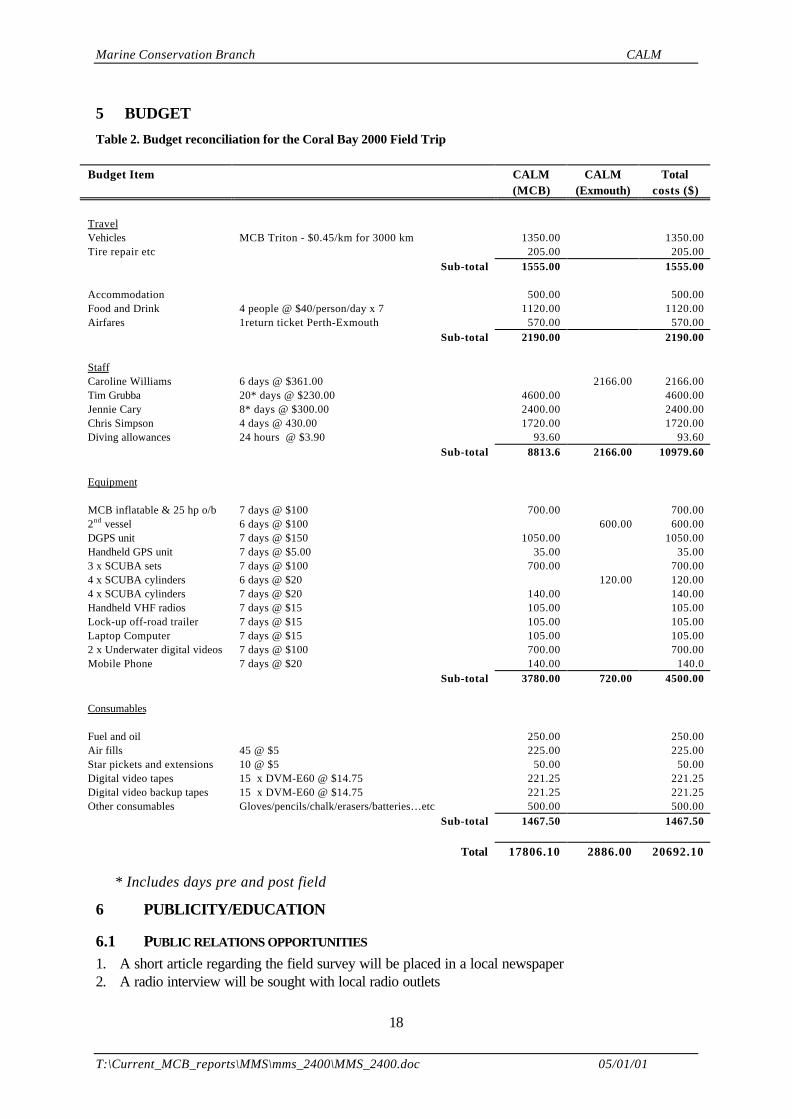
Table 2. Budget reconciliation for the Coral Bay 2000 Field Trip
Budget Item CALM(MCB)
CALM(Exmouth)
Totalcosts ($)
TravelVehicles MCB Triton - $0.45/km for 3000 km 1350.00 1350.00Tire repair etc 205.00 205.00
Sub-total 1555.00 1555.00
Accommodation 500.00 500.00Food and Drink 4 people @ $40/person/day x 7 1120.00 1120.00Airfares 1return ticket Perth-Exmouth 570.00 570.00
Sub-total 2190.00 2190.00
Staff Caroline Williams 6 days @ $361.00 2166.00 2166.00 Tim Grubba 20* days @ $230.00 4600.00 4600.00 Jennie Cary 8* days @ $300.00 2400.00 2400.00 Chris Simpson 4 days @ 430.00 1720.00 1720.00 Diving allowances 24 hours @ $3.90 93.60 93.60 Sub-total 8813.6 2166.00 10979.60
Equipment
MCB inflatable & 25 hp o/b 7 days @ $100 700.00 700.002nd vessel 6 days @ $100 600.00 600.00DGPS unit 7 days @ $150 1050.00 1050.00Handheld GPS unit 7 days @ $5.00 35.00 35.003 x SCUBA sets 7 days @ $100 700.00 700.004 x SCUBA cylinders 6 days @ $20 120.00 120.004 x SCUBA cylinders 7 days @ $20 140.00 140.00Handheld VHF radios 7 days @ $15 105.00 105.00Lock-up off-road trailer 7 days @ $15 105.00 105.00Laptop Computer 7 days @ $15 105.00 105.002 x Underwater digital videos 7 days @ $100 700.00 700.00Mobile Phone 7 days @ $20 140.00 140.0
Sub-total 3780.00 720.00 4500.00
Consumables
Fuel and oil 250.00 250.00Air fills 45 @ $5 225.00 225.00Star pickets and extensions 10 @ $5 50.00 50.00Digital video tapes 15 x DVM-E60 @ $14.75 221.25 221.25Digital video backup tapes 15 x DVM-E60 @ $14.75 221.25 221.25Other consumables Gloves/pencils/chalk/erasers/batteries…etc 500.00 500.00
Sub-total 1467.50 1467.50
Total 17806.10 2886.00 20692.10
* Includes days pre and post field
6 PUBLICITY/EDUCATION
6.1 PUBLIC RELATIONS OPPORTUNITIES
1. A short article regarding the field survey will be placed in a local newspaper2. A radio interview will be sought with local radio outlets
Marine Conservation Branch CALM
T:\Current_MCB_reports\MMS\mms_2400\MMS_2400.doc 05/01/01
19
3. A copy of the field program report will be sent to CALM Corporate Relations Division as the basisof a press release
6.2 EDUCATION OPPORTUNITIES
Nothing is planned for this field survey
6 REFERENCES
Cary J L and Grubba T L (1998). Ningaloo Marine Park Monitoring Program. Initialisation of long-term benthic monitoring sites: May 1998: Field Program Report MMSP/MW/NMP-10/98. (MarineConservation Branch, Department of Conservation and Land Management, 47 Henry Street,Fremantle, Western Australia, 6160). Unpublished report.
Cary J L, Grubba T L and Myers J (1998). Ningaloo Marine Park Monitoring Program. Establishmentof Baseline Benthic Monitoring sites: December 1998: Data Report MMSP/MW/NMP-14/98. (MarineConservation Branch, Department of Conservation and Land Management, 47 Henry Street,Fremantle, Western Australia, 6160). Unpublished report.
Cary JL, Lawrie R, Baxter K and Fuller M (1999). Establishment of Baseline Benthic Monitoring sites:1999: Spatial Rectification of Aerial Photography and Benthic Habitat Groundtruthing; 19 July – 2August. Field Program Report MMSP/MW/NMP-16/99. (Marine Conservation Branch, Departmentof Conservation and Land Management, 47 Henry Street, Fremantle, Western Australia, 6160).Unpublished report.
Christie C A, Bass D K, Neale S J, Osborne K and Oxley W G (1996). Surveys of sessile benthiccommunities using the video technique. Long-term monitoring of the Great Barrier Reef. StandardOperational Procedure Number 2. Australian Institute of Marine Science, Townsville, Queensland.
Department of Conservation and Land Management (1989). Ningaloo Marine Park Management Plan1989-1999. Management Plan No. 12. Department of Conservation and Land Management, Perth,Western Australia.
Simpson C.J, Cary J.L. and Masini R.J (1991). Destruction of corals and other reef animals by coralspawn slicks on Ningaloo Reef, Western Australia.
Simpson C.J. and Field S (1995). Survey of water quality, groundwater, sediments and benthic habitatsat Coral Bay, Ningaloo Reef, Western Australia. Technical Series 80. A report to the Department ofConservation and Land Management.. (Department of Environmental Protection Perth, WesternAustralia, 6000)
7 DISTRIBUTION LIST
SURVEY OF THE MONITORING SITES ESTABLISHED IN 1989 AFTER CORALMORTALITY IN BILLS BAY FROM THE CORAL MASS SPAWNING EVENT OFMARCH 1989.Field Program Report: MMS/NMP-23/2000
Dr Chris Simpson, Manager, Marine Conservation Branch, CALMChris Muller, Manager, Pilbara Region, CALMDoug Myers, Manager, Exmouth District, CALMCaroline Williams, Marine Conservation Officer, Exmouth District, CALMAdam Meyer, Marine Reserves Officer, Exmouth District, CALMMitzi Vance, Media Liaison Officer, Corporate Relations Division, CALM
Marine Conservation Branch CALM
T:\Current_MCB_reports\MMS\mms_2400\MMS_2400.doc 05/01/01
20
APPENDIX I: RESULTS FROM CORAL BAY 1989/1994 SURVEYS
MAJOR BENTHIC HABITAT TYPES IN 1989 (Simpson et al, 1991)SITE LIVE CORAL BEFORE
26 MARCH
(%)
LIVE CORAL COVER
BETWEEN 3-5 APRIL
(%)
BLEACHED CORAL
COVER BETWEEN 3-5APRIL
(%)mean se mean se mean Se
1 38.8 4.0 0.0 3.8.8 4.02 52.7 7.3 23.5 1.7 29.2 5.63 43.0 11.8 7.2 7.2 35.8 4.64 65.8 7.0 65.8 7.0 0.05 38.2 6.6 0.0 38.2 6.66 69.4 10.6 3.2 3.2 66.2 13.87 51.5 1.3 10.7 3.5 40.8 2.28 52.0 2.0 52.0 2.0 0.09 0.0 0.010 29.0 14.2 0.0 29.0 14.211 39.2 0.6 5.2 2.4 34.0 2.812 43.6 1.6 9.2 2.8 4.4 4.413 0.0 0.014 19.1 14.3 1.2 1.2 17.9 15.515 47.7 2.9 13.5 6.3 34.2 3.416 33.3 8.3 33.3 8.3 0.017 55.2 1.6 55.2 1.6 0.0
MAJOR BENTHIC HABITAT TYPES IN 1994 (Simpson & Field 1995)SITE LIVE CORAL
(%)DEAD CORAL
(%)SAND
(%)1 4.5 46.1 48.42 42.9 45.9 11.23 42.6 57.4 0.04 62.2 28.8 9.05 5.9 88.3 5.86 14.4 85.2 0.47 7.2 92.8 0.08 54.9 28.5 16.69 4.0 79.0 17.010 16.2 58.1 25.811 19.6 78.4 2.012 68.1 30.3 2.413 13.4 61.0 25.614 5.0 76.6 18.415 9.3 84.5 6.216 61.4 29.8 10.417 41.6 58.4 0.0
Marine Conservation Branch CALM
T:\Current_MCB_reports\MMS\mms_2400\MMS_2400.doc 05/01/01
21
APPENDIX II: BLANK DATA RECORDING SHEETS
Marine Conservation Branch CALM
T:\Current_MCB_reports\MMS\mms_2400\MMS_2400.doc 05/01/01
22
TRANSECT DATA SHEET
Project NINGALOO MARINE PARK MONITORING PROGRAM Field Survey MAY 2000
Site No. N Site Name Date Recorder
Time Video tape no. NMPMP/bvt/ /# Video operator
T1 Length (m) 50 Compass bearing (°° ) Distance to T2 (m)
Transect DGPS Lat DGPS Long Depth (m) Picket type Picket ht (m)
Start ° ’ S ° ’ E
Finish ° ’ S ° ’ E
Notes: (eg. description of habitat and dominant species along transect)
T2 Length (m) 50 Compass bearing (°° ) Distance to T3 (m)
Transect DGPS Lat DGPS Long Depth (m) Picket type Picket ht (m)
Start ° ’ S ° ’ E
Finish ° ’ S ° ’ E
Notes:
T3 Length (m) 50 Compass bearing (°° ) Distance to T1 (m)
Transect DGPS Lat DGPS Long Depth (m) Picket type Picket ht (m)
Start ° ’ S ° ’ E
Marine Conservation Branch CALM
T:\Current_MCB_reports\MMS\mms_2400\MMS_2400.doc 05/01/01
23
Finish ° ’ S ° ’ E
Notes:
Marine Conservation Branch CALM
T:\Current_MCB_reports\MMS\mms_2400\MMS_2400.doc 05/01/01
24
LONG-TERM MONITORING SITE DATA SHEET
Project NINGALOO MARINE PARK MONITORING PROGRAM Field Survey MAY 2000
Site No. N Site Name Date Recorder
GPS Latitude GPS Longitude Differential
° ’ S ° ’ E Yes No
Habitat type
Location of nearest transect fromGPS position
Transect No. T Compassbearing(°° )
Distance (m)
Site Map (include north indicator, scale, vessel location, water depth, transect locations & other features of interest):
Marine Conservation Branch CALM
T:\Current_MCB_reports\MMS\mms_2400\MMS_2400.doc 05/01/01
25
Notes:
Marine Conservation Branch CALM
T:\Current_MCB_reports\MMS\mms_2400\MMS_2400.doc 05/01/01
26
HABITAT DATA SHEET
Project NINGALOO MARINE PARK MONITORING PROGRAM Field Survey MAY 2000
Site No. N Site Name Date Recorder
Vessel Time Weather
Sea Water depth (m) Water visibility(m)
GPS Latitude GPS Longitude Differential
° ’ S ° ’ E Yes No
Site location
Habitat Description
Dominant Species
Seagrass
Macro-algae
Coral
Fish
Invertebrates
Other Features
Impact or Activity
Marine Conservation Branch CALM
T:\Current_MCB_reports\MMS\mms_2400\MMS_2400.doc 05/01/01
27
Video reference NMPMP/bvt/ /# Aerial reference /WA /RUN /
Slide reference Print reference
VIDEO DATA SHEET
Project NINGALOO MARINE PARK MONITORING PROGRAM Field Survey MAY 2000
Site No. N Site Name Date Recorder
Start time Finish time Depth (m) Visibility(m)
Underwater Video System Canon MV1 digital camcorder in Amphibico housing.
Focus mode Exposure mode Program mode White balance mode
Auto Manual Auto Manual Sports High-speed
Auto Outdoor
Lens system Filters Lights
Wide-angle
Zoom-macro
None Red Yellow Orange On Off
Video operator Tape no. NMPMP/bvt/ /# Height abovesubstrate (cm)
Time coding for all videofootage at site:
From: : : : To: : : :
Transecttime coding
Start Finish Total time(mins/secs)
T1 : : : : : : .
Marine Conservation Branch CALM
T:\Current_MCB_reports\MMS\mms_2400\MMS_2400.doc 05/01/01
28
T2 : : : : : : .
T3 : : : : : : .
Notes
Marine Conservation Branch CALM
T:\Current_MCB_reports\MMS\mms_2400\MMS_2400.doc 05/01/01
29
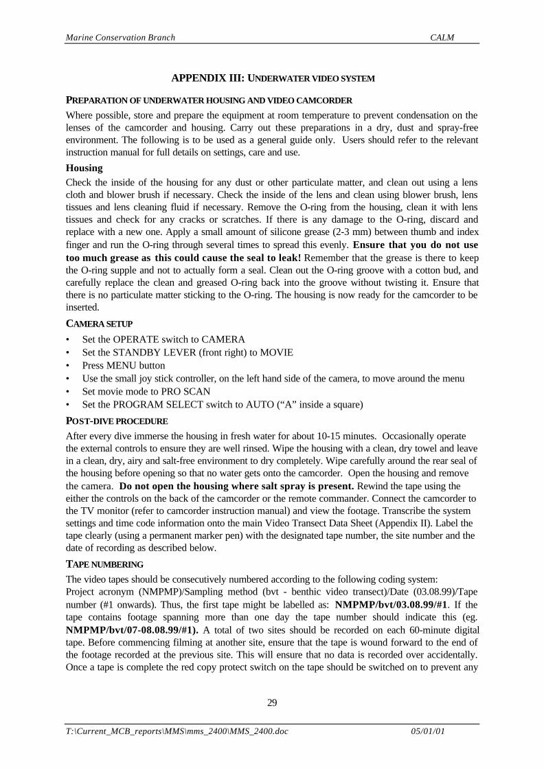
APPENDIX III: UNDERWATER VIDEO SYSTEM
PREPARATION OF UNDERWATER HOUSING AND VIDEO CAMCORDER
Where possible, store and prepare the equipment at room temperature to prevent condensation on thelenses of the camcorder and housing. Carry out these preparations in a dry, dust and spray-freeenvironment. The following is to be used as a general guide only. Users should refer to the relevantinstruction manual for full details on settings, care and use.
HousingCheck the inside of the housing for any dust or other particulate matter, and clean out using a lenscloth and blower brush if necessary. Check the inside of the lens and clean using blower brush, lenstissues and lens cleaning fluid if necessary. Remove the O-ring from the housing, clean it with lenstissues and check for any cracks or scratches. If there is any damage to the O-ring, discard andreplace with a new one. Apply a small amount of silicone grease (2-3 mm) between thumb and indexfinger and run the O-ring through several times to spread this evenly. Ensure that you do not usetoo much grease as this could cause the seal to leak! Remember that the grease is there to keepthe O-ring supple and not to actually form a seal. Clean out the O-ring groove with a cotton bud, andcarefully replace the clean and greased O-ring back into the groove without twisting it. Ensure thatthere is no particulate matter sticking to the O-ring. The housing is now ready for the camcorder to beinserted.
CAMERA SETUP
• Set the OPERATE switch to CAMERA• Set the STANDBY LEVER (front right) to MOVIE• Press MENU button• Use the small joy stick controller, on the left hand side of the camera, to move around the menu• Set movie mode to PRO SCAN• Set the PROGRAM SELECT switch to AUTO (“A” inside a square)
POST-DIVE PROCEDURE
After every dive immerse the housing in fresh water for about 10-15 minutes. Occasionally operatethe external controls to ensure they are well rinsed. Wipe the housing with a clean, dry towel and leavein a clean, dry, airy and salt-free environment to dry completely. Wipe carefully around the rear seal ofthe housing before opening so that no water gets onto the camcorder. Open the housing and removethe camera. Do not open the housing where salt spray is present. Rewind the tape using theeither the controls on the back of the camcorder or the remote commander. Connect the camcorder tothe TV monitor (refer to camcorder instruction manual) and view the footage. Transcribe the systemsettings and time code information onto the main Video Transect Data Sheet (Appendix II). Label thetape clearly (using a permanent marker pen) with the designated tape number, the site number and thedate of recording as described below.
TAPE NUMBERING
The video tapes should be consecutively numbered according to the following coding system:Project acronym (NMPMP)/Sampling method (bvt - benthic video transect)/Date (03.08.99)/Tapenumber (#1 onwards). Thus, the first tape might be labelled as: NMPMP/bvt/03.08.99/#1. If thetape contains footage spanning more than one day the tape number should indicate this (eg.NMPMP/bvt/07-08.08.99/#1). A total of two sites should be recorded on each 60-minute digitaltape. Before commencing filming at another site, ensure that the tape is wound forward to the end ofthe footage recorded at the previous site. This will ensure that no data is recorded over accidentally.Once a tape is complete the red copy protect switch on the tape should be switched on to prevent any
Marine Conservation Branch CALM
T:\Current_MCB_reports\MMS\mms_2400\MMS_2400.doc 05/01/01
30
loss of site data. The tapes should be stored in a waterproof container and duplicated at the end of thefield trip.
Marine Conservation Branch CALM
T:\Current_MCB_reports\MMS\mms_2400\MMS_2400.doc 05/01/01
31
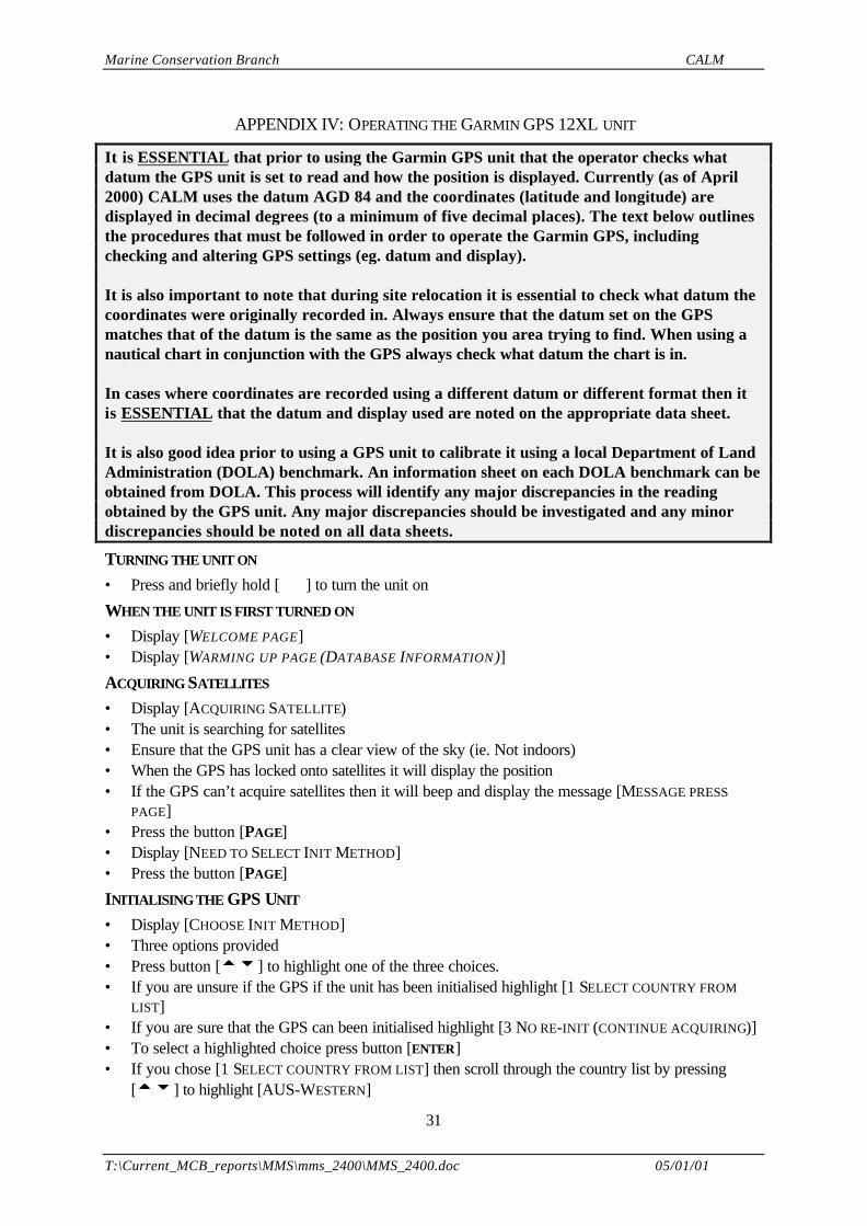
APPENDIX IV: OPERATING THE GARMIN GPS 12XL UNIT
It is ESSENTIAL that prior to using the Garmin GPS unit that the operator checks whatdatum the GPS unit is set to read and how the position is displayed. Currently (as of April2000) CALM uses the datum AGD 84 and the coordinates (latitude and longitude) aredisplayed in decimal degrees (to a minimum of five decimal places). The text below outlinesthe procedures that must be followed in order to operate the Garmin GPS, includingchecking and altering GPS settings (eg. datum and display).
It is also important to note that during site relocation it is essential to check what datum thecoordinates were originally recorded in. Always ensure that the datum set on the GPSmatches that of the datum is the same as the position you area trying to find. When using anautical chart in conjunction with the GPS always check what datum the chart is in.
In cases where coordinates are recorded using a different datum or different format then itis ESSENTIAL that the datum and display used are noted on the appropriate data sheet.
It is also good idea prior to using a GPS unit to calibrate it using a local Department of LandAdministration (DOLA) benchmark. An information sheet on each DOLA benchmark can beobtained from DOLA. This process will identify any major discrepancies in the readingobtained by the GPS unit. Any major discrepancies should be investigated and any minordiscrepancies should be noted on all data sheets.
TURNING THE UNIT ON
• Press and briefly hold [ ] to turn the unit on
WHEN THE UNIT IS FIRST TURNED ON
• Display [WELCOME PAGE]• Display [WARMING UP PAGE (DATABASE INFORMATION )]
ACQUIRING SATELLITES
• Display [ACQUIRING SATELLITE)• The unit is searching for satellites• Ensure that the GPS unit has a clear view of the sky (ie. Not indoors)• When the GPS has locked onto satellites it will display the position• If the GPS can’t acquire satellites then it will beep and display the message [MESSAGE PRESS
PAGE]• Press the button [PAGE]• Display [NEED TO SELECT INIT METHOD]• Press the button [PAGE]
INITIALISING THE GPS UNIT
• Display [CHOOSE INIT METHOD]• Three options provided• Press button [ttuu ] to highlight one of the three choices.• If you are unsure if the GPS if the unit has been initialised highlight [1 SELECT COUNTRY FROM
LIST]• If you are sure that the GPS can been initialised highlight [3 NO RE-INIT (CONTINUE ACQUIRING)]• To select a highlighted choice press button [ENTER]• If you chose [1 SELECT COUNTRY FROM LIST] then scroll through the country list by pressing
[ttuu ] to highlight [AUS-WESTERN]
Marine Conservation Branch CALM
T:\Current_MCB_reports\MMS\mms_2400\MMS_2400.doc 05/01/01
32
• Select the highlighted choice by pressing [ENTER]• The GPS will display [ACQUIRING SATELLITE]
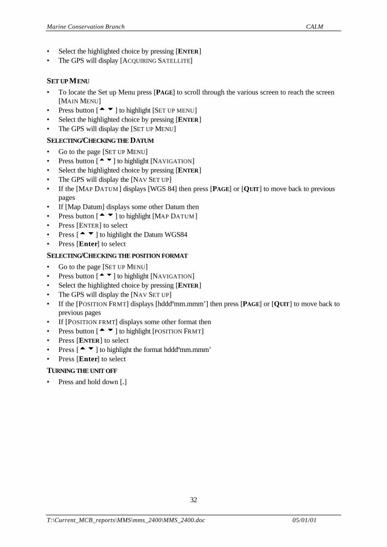
SET UP MENU
• To locate the Set up Menu press [PAGE] to scroll through the various screen to reach the screen[MAIN MENU]
• Press button [ttuu ] to highlight [SET UP MENU]• Select the highlighted choice by pressing [ENTER]• The GPS will display the [SET UP MENU]
SELECTING/CHECKING THE DATUM
• Go to the page [SET UP MENU]• Press button [tu] to highlight [NAVIGATION]• Select the highlighted choice by pressing [ENTER]• The GPS will display the [NAV SET UP]• If the [MAP DATUM ] displays [WGS 84] then press [PAGE] or [QUIT] to move back to previous
pages• If [Map Datum] displays some other Datum then• Press button [ttuu ] to highlight [MAP DATUM ]• Press [ENTER] to select• Press [ttuu ] to highlight the Datum WGS84• Press [Enter] to select
SELECTING/CHECKING THE POSITION FORMAT
• Go to the page [SET UP MENU]• Press button [tu] to highlight [NAVIGATION]• Select the highlighted choice by pressing [ENTER]• The GPS will display the [NAV SET UP]• If the [POSITION FRMT] displays [hdddºmm.mmm’] then press [PAGE] or [QUIT] to move back to
previous pages• If [POSITION FRMT] displays some other format then• Press button [ttuu ] to highlight [POSITION FRMT]• Press [ENTER] to select• Press [ttuu ] to highlight the format hdddºmm.mmm’• Press [Enter] to select
TURNING THE UNIT OFF
• Press and hold down [ ]
Marine Conservation Branch CALM
T:\Current_MCB_reports\MMS\mms_2400\MMS_2400.doc 05/01/01
33
APPENDIX V: DATA SHEETS FOR NMPMP PERMENANT TRANSECT SITES TO BE RE-LOCATED
Marine Conservation Branch CALM
T:\Current_MCB_reports\MMS\mms_2400\MMS_2400.doc 05/01/01
34
TRANSECT DATA SHEET
Project NINGALOO MARINE PARK MONITORING PROGRAM Field Survey MAY 1998
Site No. N1 Site Name Bundegi Date 5/5/98 Recorder Lapwood
Time 12.10 Video tape no. NMPMP/bvt/05.05.98 /#1 Video operator Cary
T1 Length (m) 50 Compass bearing (°° ) 60 Distance to T2 (m) 10
Transect DGPS Lat DGPS Long Depth (m) Picket type Picket ht (m)
Start 21° 49.699’ S 114° 10.718’ E 3.0 60 cm Star/Steel
0.15
Finish ° ’ S ° ’ E
Notes: (eg. description of habitat and dominant species along transect)Live hard coral: 35%; Dead coral: 50%; Algae: 4%; and Abiotic: 11%
T2 Length (m) 50 Compass bearing (°° ) 60 Distance to T2 (m) 10
Transect DGPS Lat DGPS Long Depth (m) Picket type Picket ht (m)
Start 21° 49.725’ S 114° 10.698’ E 3.0 60cm Star/Steel
0.15
Finish ° ’ S ° ’ E
Notes:Live hard coral: 11%; Dead coral: 62%; Algae: 11%; and Abiotic: 17%
T3 Length (m) 50 Compass bearing (°° ) 60
Transect DGPS Lat DGPS Long Depth (m) Picket type Picket ht (m)
Start 21° 49.750’ S 114° 10.682’ E 3.0 60cm Star/Steel
0.15
Finish 21° 49.776’ S 114° 10.678’ E 3 60cm Star/Steel
0.15
Notes:Live coral: 15%; Dead coral: 51%; Algae: 3%; and Abiotic: 32%
Marine Conservation Branch CALM
T:\Current_MCB_reports\MMS\mms_2400\MMS_2400.doc 05/01/01
35
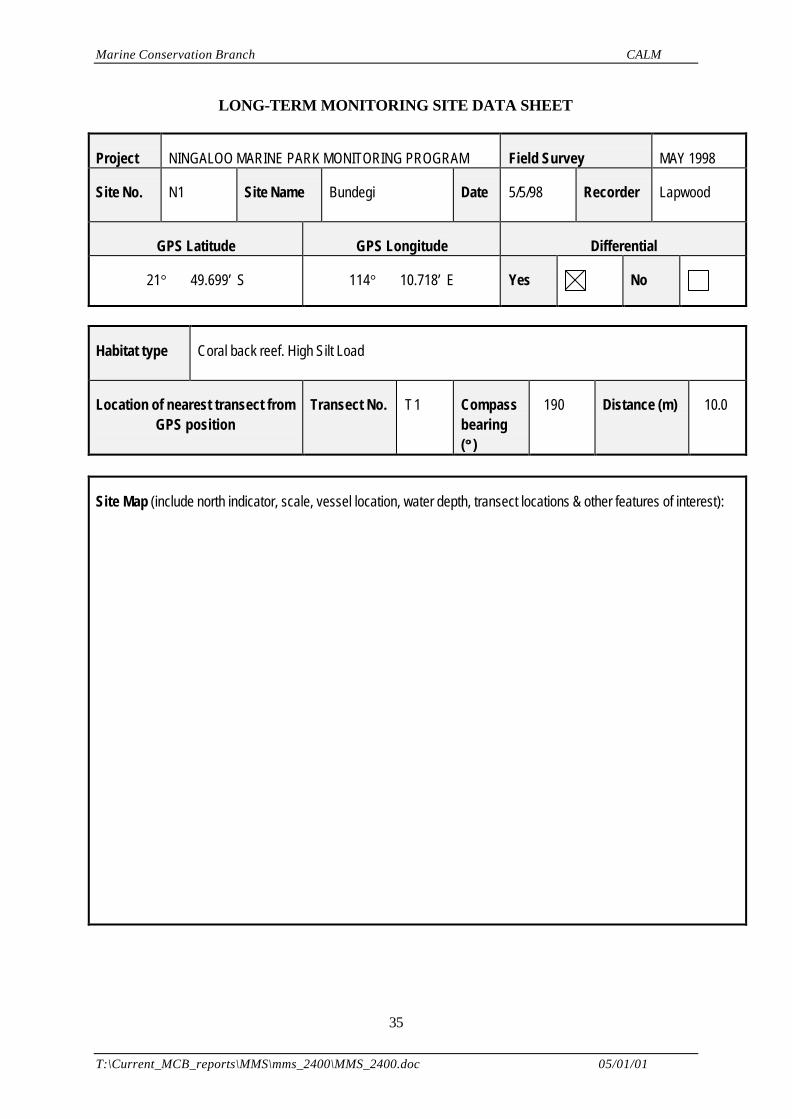
LONG-TERM MONITORING SITE DATA SHEET
Project NINGALOO MARINE PARK MONITORING PROGRAM Field Survey MAY 1998
Site No. N1 Site Name Bundegi Date 5/5/98 Recorder Lapwood
GPS Latitude GPS Longitude Differential
21° 49.699’ S 114° 10.718’ E Yes No
Habitat type Coral back reef. High Silt Load
Location of nearest transect fromGPS position
Transect No. T1 Compassbearing(°° )
190 Distance (m) 10.0
Site Map (include north indicator, scale, vessel location, water depth, transect locations & other features of interest):
Marine Conservation Branch CALM
T:\Current_MCB_reports\MMS\mms_2400\MMS_2400.doc 05/01/01
36
Notes:
HABITAT DATA SHEET
Project NINGALOO MARINE PARK MONITORING PROGRAM Field Survey MAY 1998
Site No. N1 Site Name Bundegi Date 5/5/98 Recorder Cary
Vessel AIMS 4.3M NAIADCALM 3.8M ZODIAC
Time 1140 Weather 25 Knots SE
Sea 20cm Waves Water depth (m) 3.0 Water visibility(m)
7.0
GPS Latitude GPS Longitude Differential
21° 49.699’ S 114° 10.718’ E Yes No
Site location Just north of the Bundegi Public Jetty.
Habitat Description
Depth: 2.8-3.0mImmediately inshore of reef platform; Dense (30-40%) live coral cover. High level of sedimentation.Live coral: 20% (mean)Dead coral: 54% (mean)Algae: 6% (mean)Abiotic: 20% (mean)
Dominant Species
Seagrass
Macro-algae Dictyota sp. (wide-branch)
Coral Montipora & Acropora sp. (dominant). A hyacynathus plates and comrymbose forms
Fish few fish species observed; medium-sized Scarids; Damsels, Chromis sp.; 4 Coral trout
Marine Conservation Branch CALM
T:\Current_MCB_reports\MMS\mms_2400\MMS_2400.doc 05/01/01
37
Invertebrates
Other Features
Impact or Activity
Storm damage evident—few years ago; upturned plates. High level of sedimentation.
Video reference NMPMP/bvt/05.05.98 /#1 Aerial reference 1985/WA 2286C /RUN /5157
Slide reference Print reference
Marine Conservation Branch CALM
T:\Current_MCB_reports\MMS\mms_2400\MMS_2400.doc 05/01/01
38
HABITAT DATA SHEET
Project NINGALOO MARINE PARK MONITORING PROGRAM Field Survey AUGUST1999
Site No. N1 Site Name Bundegi (Re-survey of1998 survey)
Date 4-08-99 Recorder Cary
Vessel AIMS 4.3M NAIADCALM 3.5M Zodiac
Time 15:00 Weather
Sea Calm Water depth (m) 3m Water visibility(m)
10m
GPS Latitude GPS Longitude Differential
21° 49.699’ S 114° 10.718’ E Yes No
Site location Gulf side of NW Cape, north of Exmouth
Habitat Description
There were obvious signs of damage to corals from cyclone Vance (March 1999)Branching Acropora broken into small pieces
Dominant Species
Seagrass
Macro-algae Significant algal growth over dead coral
Coral Acropora (Branching, Corymbose), Montipora
Fish Flathead (some50cm), Wrasse, Damsels, Parrot fish
Invertebrates
1X Crown of thorn Starfish, ‘Haliotis’ feather star
Other Features
Cyclone Vance passed over Exmouth in March 1999.Winds were from the east
Impact or Activity
Marine Conservation Branch CALM
T:\Current_MCB_reports\MMS\mms_2400\MMS_2400.doc 05/01/01
39
A lot of litter in general area- a lot could be from land due to cyclone Vance as Spinifex were also found.1x Crown of Thorns starfish observedCrayfish foundPipe, terracotta, discarded octopus trapCans >20; pvc pipe 5m X 0.12m; boat windscreen; rope at 3 sitesChain 1m X 20cm thick; 2X timber (one 1.5 X 0.5m X 0.2m)
Video reference NMPMP/ bvt/4-08-99 /#1 Aerial reference 5157/WA 2286/RUN3/840048
Slide reference Print reference TRANSECT LOCATION DATA SHEET
Project NINGALOO MARINE PARK MONITORING PROGRAM Field Survey AUGUST1999
Site No. N1 Site Name Bundegi (Re- survey of1998 survey)
Date 4-8-99 Recorder Cary
Time 15:00 Video tape no. NMPMP/bvt/04-08-99 /# 1 Video operator Cary
T1 Length (m) 50 Compass bearing (°° ) Distance to T2 (m)
Transect DGPS Lat DGPS Long Depth (m) Picket type Picket ht (m)
Start 98 21° 49.699’ S 114° 10.718’ E
Finish ° ’ S ° ’ E
Notes: (eg. Description of habitat and dominant species along transect)This site was established in 1998 and revisited in August 1999
T2 Length (m) 50 Compass bearing (°° ) Distance to T3 (m)
Transect DGPS Lat DGPS Long Depth (m) Picket type Picket ht (m)
Start 98 21° 49.725’ S 114° 10.698’ E
Finish ° ’ S ° ’ E
Marine Conservation Branch CALM
T:\Current_MCB_reports\MMS\mms_2400\MMS_2400.doc 05/01/01
40
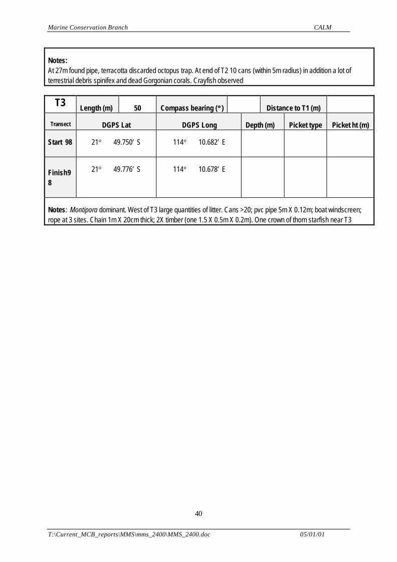
Notes:At 27m found pipe, terracotta discarded octopus trap. At end of T2 10 cans (within 5m radius) in addition a lot ofterrestrial debris spinifex and dead Gorgonian corals. Crayfish observed
T3 Length (m) 50 Compass bearing (°° ) Distance to T1 (m)
Transect DGPS Lat DGPS Long Depth (m) Picket type Picket ht (m)
Start 98 21° 49.750’ S 114° 10.682’ E
Finish98
21° 49.776’ S 114° 10.678’ E
Notes: Montipora dominant. West of T3 large quantities of litter. Cans >20; pvc pipe 5m X 0.12m; boat windscreen;rope at 3 sites. Chain 1m X 20cm thick; 2X timber (one 1.5 X 0.5m X 0.2m). One crown of thorn starfish near T3
Marine Conservation Branch CALM
T:\Current_MCB_reports\MMS\mms_2400\MMS_2400.doc 05/01/01
41
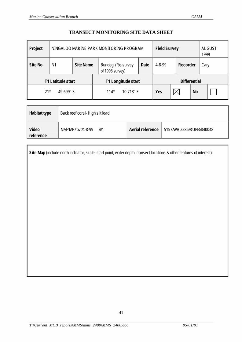
TRANSECT MONITORING SITE DATA SHEET
Project NINGALOO MARINE PARK MONITORING PROGRAM Field Survey AUGUST1999
Site No. N1 Site Name Bundegi (Re-surveyof 1998 survey)
Date 4-8-99 Recorder Cary
T1 Latitude start T1 Longitude start Differential
21° 49.699’ S 114° 10.718’ E Yes No
Habitat type Back reef coral- High silt load
Videoreference
NMPMP/ bvt/4-8-99 /#1 Aerial reference 5157/WA 2286/RUN3/840048
Site Map (include north indicator, scale, start point, water depth, transect locations & other features of interest):
Marine Conservation Branch CALM
T:\Current_MCB_reports\MMS\mms_2400\MMS_2400.doc 05/01/01
42
Notes:Re survey N1 transect. No wind and flooding tide when re- surveyed
Bearings T3(Start) T3(End)Dolphin on Pier 055° 045°End of Jetty 309° 320°White tower 218° 217°

Marine Conservation Branch CALM
T:\Current_MCB_reports\MMS\mms_2400\MMS_2400.doc 05/01/01
43
TRANSECT DATA SHEET
Project NINGALOO MARINE PARK MONITORING PROGRAM Field Survey MAY 1998
Site No. N19 Site Name Bundegi Sanctuary Date 5/5/98 Recorder Lapwood
Time 13.00 Video tape no. NMPMP/bvt/05.05.98 /#1 Video operator Cary
T1 Length (m) 50 Compass bearing (°° ) Distance to T2 (m) 10.0
Transect DGPS Lat DGPS Long Depth (m) Picket type Picket ht (m)
Start 21° 51.409’ S 114° 09.982’ E 1.5-2.0 60cmStar/Steel
0.15
Finish ° ’ S ° ’ E
Notes: (eg. description of habitat and dominant species along transect)Live coral: 24%; Dead coral: 22%; Algae: 0%; and Abiotic: 54%
T2 Length (m) 50 Compass bearing (°° ) Distance to T2 (m) 10.0
Transect DGPS Lat DGPS Long Depth (m) Picket type Picket ht (m)
Start 21° 51.429’ S 114° 09.959’ E 1.5-2.0 60cmStar/Steel
0.15
Finish ° ’ S ° ’ E
Notes:Live coral: 22%; Dead coral: 30%; Algae: 0%; and Abiotic: 53%
T3 Length (m) 50 Compass bearing (°° )
Transect DGPS Lat DGPS Long Depth (m) Picket type Picket ht (m)
Start 21° 51.453’ S 114° 09.942’ E 1.5-2.0 60cmStar/Steel
0.15
Finish 21° 51.472’ S 114° 09.923’ E 1.5-2.0 60cmStar/Steel
0.15
Notes:Live coral: 19%; Dead coral: 66%; Algae: 0%; and Abiotic: 41%
Marine Conservation Branch CALM
T:\Current_MCB_reports\MMS\mms_2400\MMS_2400.doc 05/01/01
44
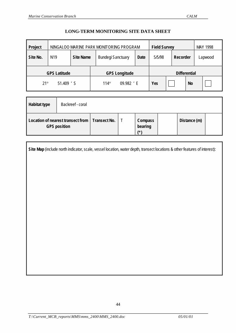
LONG-TERM MONITORING SITE DATA SHEET
Project NINGALOO MARINE PARK MONITORING PROGRAM Field Survey MAY 1998
Site No. N19 Site Name Bundegi Sanctuary Date 5/5/98
Recorder Lapwood
GPS Latitude GPS Longitude Differential
21° 51.409 ’ S 114° 09.982 ’ E Yes No
Habitat type Backreef - coral
Location of nearest transect fromGPS position
Transect No. T Compassbearing(°° )
Distance (m)
Site Map (include north indicator, scale, vessel location, water depth, transect locations & other features of interest):
Marine Conservation Branch CALM
T:\Current_MCB_reports\MMS\mms_2400\MMS_2400.doc 05/01/01
45
Notes:
HABITAT DATA SHEET
Project NINGALOO MARINE PARK MONITORING PROGRAM Field Survey MAY 1998
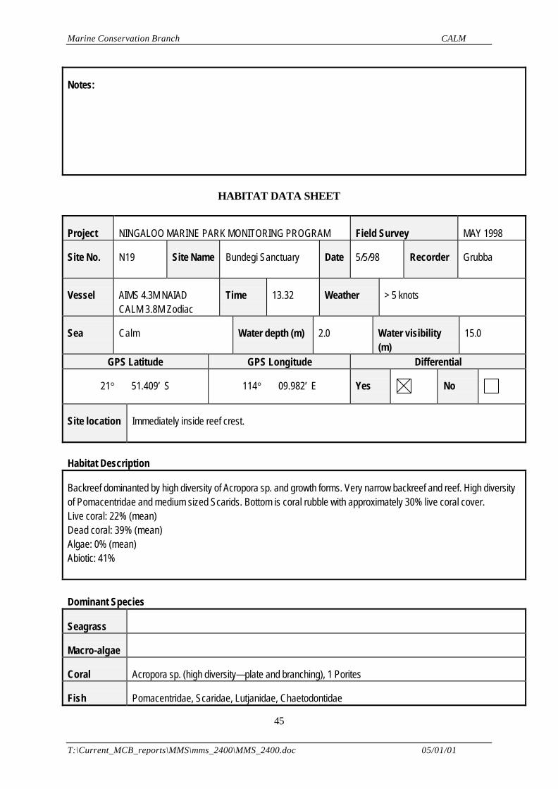
Site No. N19 Site Name Bundegi Sanctuary Date 5/5/98 Recorder Grubba
Vessel AIMS 4.3M NAIADCALM 3.8M Zodiac
Time 13.32 Weather > 5 knots
Sea Calm Water depth (m) 2.0 Water visibility(m)
15.0
GPS Latitude GPS Longitude Differential
21° 51.409’ S 114° 09.982’ E Yes No
Site location Immediately inside reef crest.
Habitat Description
Backreef dominanted by high diversity of Acropora sp. and growth forms. Very narrow backreef and reef. High diversityof Pomacentridae and medium sized Scarids. Bottom is coral rubble with approximately 30% live coral cover.Live coral: 22% (mean)Dead coral: 39% (mean)Algae: 0% (mean)Abiotic: 41%
Dominant Species
Seagrass
Macro-algae
Coral Acropora sp. (high diversity—plate and branching), 1 Porites
Fish Pomacentridae, Scaridae, Lutjanidae, Chaetodontidae
Marine Conservation Branch CALM
T:\Current_MCB_reports\MMS\mms_2400\MMS_2400.doc 05/01/01
46
Invertebrates
1 Panulirus versicolor
Other Features
1 Potato grouper (epinephelus tukula); 1 Reef Whitetip shark (Triaenodon obesus), uniquely shaped Acropora sp.
Impact or Activity
No visual human impacts; Previous cyclone damage
Video reference NMPMP/bvt/05.05.98 /#1 Aerial reference 1985/WA 3434C /RUN /5154
Slide reference Print reference
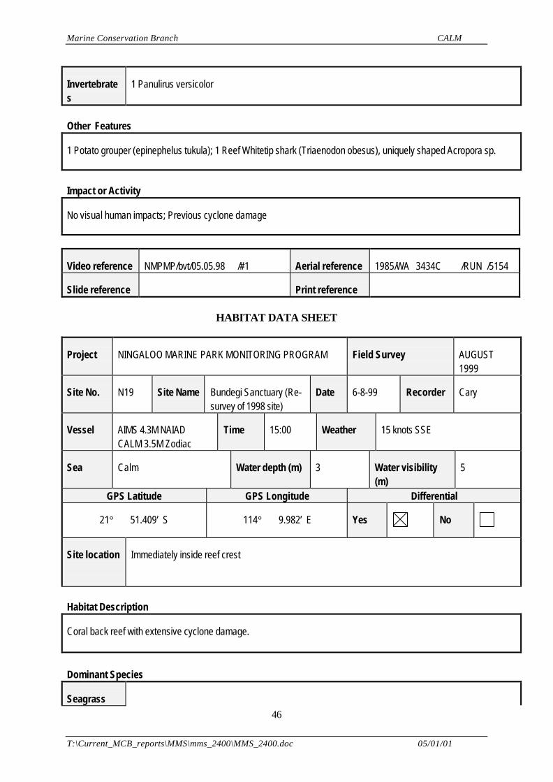
HABITAT DATA SHEET
Project NINGALOO MARINE PARK MONITORING PROGRAM Field Survey AUGUST1999
Site No. N19 Site Name Bundegi Sanctuary (Re-survey of 1998 site)
Date 6-8-99 Recorder Cary
Vessel AIMS 4.3M NAIADCALM 3.5M Zodiac
Time 15:00 Weather 15 knots SSE
Sea Calm Water depth (m) 3 Water visibility(m)
5
GPS Latitude GPS Longitude Differential
21° 51.409’ S 114° 9.982’ E Yes No
Site location Immediately inside reef crest
Habitat Description
Coral back reef with extensive cyclone damage.
Dominant Species
Seagrass
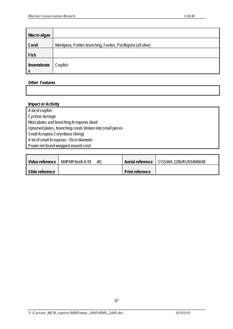
Marine Conservation Branch CALM
T:\Current_MCB_reports\MMS\mms_2400\MMS_2400.doc 05/01/01
47
Macro-algae
Coral Montipora, Porites branching, Favites, Pocillopora (all alive)
Fish
Invertebrates
Crayfish
Other Features
Impact or ActivityA lot of crayfishCyclone damageMost plates and branching Acroporas deadUpturned plates, branching corals broken into small piecesSmall Acropora Corymbose (living)A lot of small Acroporas- 10cm diameterPrawn net found wrapped around coral
Video reference NMPMP/bvt/6-8-99 /#2 Aerial reference 5155/WA 2286/RUN3/840048
Slide reference Print reference
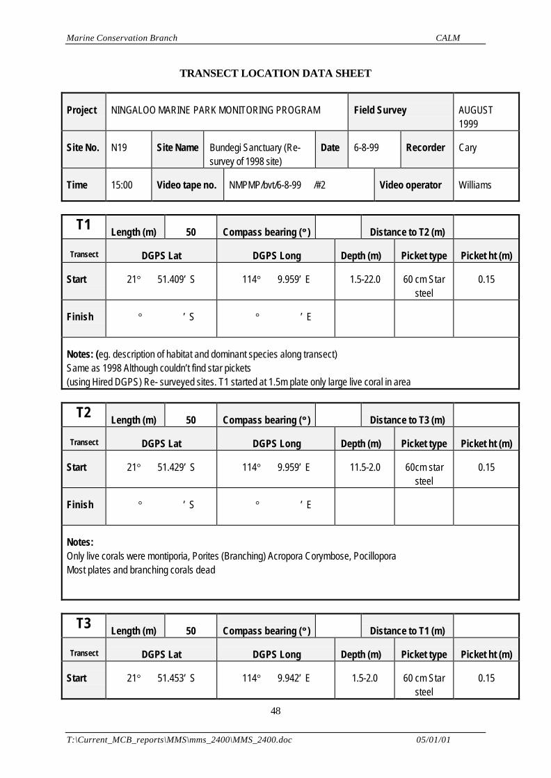
Marine Conservation Branch CALM
T:\Current_MCB_reports\MMS\mms_2400\MMS_2400.doc 05/01/01
48
TRANSECT LOCATION DATA SHEET
Project NINGALOO MARINE PARK MONITORING PROGRAM Field Survey AUGUST1999
Site No. N19 Site Name Bundegi Sanctuary (Re-survey of 1998 site)
Date 6-8-99 Recorder Cary
Time 15:00 Video tape no. NMPMP/bvt/6-8-99 /#2 Video operator Williams
T1 Length (m) 50 Compass bearing (°° ) Distance to T2 (m)
Transect DGPS Lat DGPS Long Depth (m) Picket type Picket ht (m)
Start 21° 51.409’ S 114° 9.959’ E 1.5-22.0 60 cm Starsteel
0.15
Finish ° ’ S ° ’ E
Notes: (eg. description of habitat and dominant species along transect)Same as 1998 Although couldn’t find star pickets(using Hired DGPS) Re- surveyed sites. T1 started at 1.5m plate only large live coral in area
T2 Length (m) 50 Compass bearing (°° ) Distance to T3 (m)
Transect DGPS Lat DGPS Long Depth (m) Picket type Picket ht (m)
Start 21° 51.429’ S 114° 9.959’ E 11.5-2.0 60cm starsteel
0.15
Finish ° ’ S ° ’ E
Notes:Only live corals were montiporia, Porites (Branching) Acropora Corymbose, PocilloporaMost plates and branching corals dead
T3 Length (m) 50 Compass bearing (°° ) Distance to T1 (m)
Transect DGPS Lat DGPS Long Depth (m) Picket type Picket ht (m)
Start 21° 51.453’ S 114° 9.942’ E 1.5-2.0 60 cm Starsteel
0.15
Marine Conservation Branch CALM
T:\Current_MCB_reports\MMS\mms_2400\MMS_2400.doc 05/01/01
49
Finish 21° 51.453’ S 114° 9.923’ E 1.5-2.0 60cm Starsteel
0.15
Notes:Live corals- Montipora, Porites (Branching), Pocillopora, Favites.
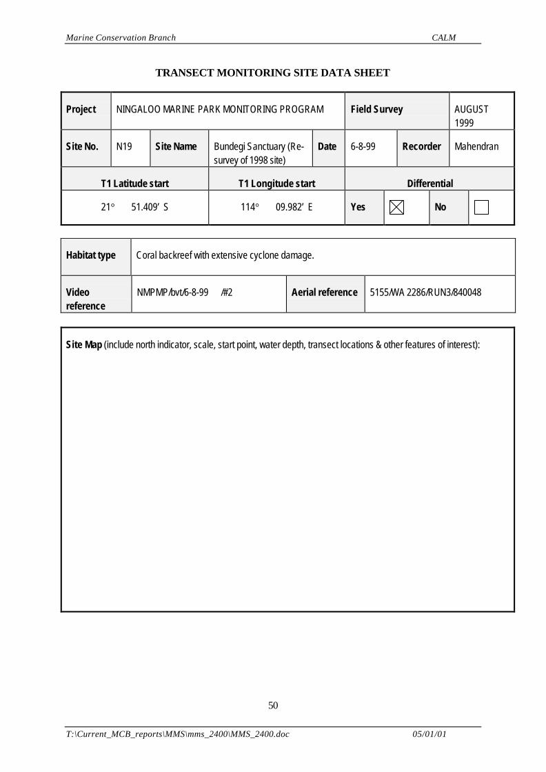
Marine Conservation Branch CALM
T:\Current_MCB_reports\MMS\mms_2400\MMS_2400.doc 05/01/01
50
TRANSECT MONITORING SITE DATA SHEET
Project NINGALOO MARINE PARK MONITORING PROGRAM Field Survey AUGUST1999
Site No. N19 Site Name Bundegi Sanctuary (Re-survey of 1998 site)
Date 6-8-99 Recorder Mahendran
T1 Latitude start T1 Longitude start Differential
21° 51.409’ S 114° 09.982’ E Yes No
Habitat type Coral backreef with extensive cyclone damage.
Videoreference
NMPMP/bvt/6-8-99 /#2 Aerial reference 5155/WA 2286/RUN3/840048
Site Map (include north indicator, scale, start point, water depth, transect locations & other features of interest):
Marine Conservation Branch CALM
T:\Current_MCB_reports\MMS\mms_2400\MMS_2400.doc 05/01/01
51
Notes:Transect site established 5-5-98Re-survey 6-8-99Most plates and branching Acroporas dead.Upturned plates, branching corals broken into small pieces
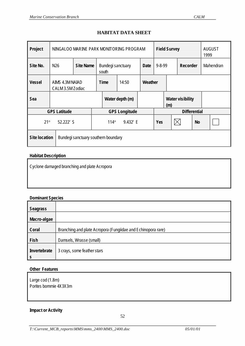
Marine Conservation Branch CALM
T:\Current_MCB_reports\MMS\mms_2400\MMS_2400.doc 05/01/01
52
HABITAT DATA SHEET
Project NINGALOO MARINE PARK MONITORING PROGRAM Field Survey AUGUST1999
Site No. N26 Site Name Bundegi sanctuarysouth
Date 9-8-99 Recorder Mahendran
Vessel AIMS 4.3M NAIADCALM 3.5M Zodiac
Time 14:50 Weather
Sea Water depth (m) Water visibility(m)
GPS Latitude GPS Longitude Differential
21° 52.222’ S 114° 9.432’ E Yes No
Site location Bundegi sanctuary southern boundary
Habitat Description
Cyclone damaged branching and plate Acropora
Dominant Species
Seagrass
Macro-algae
Coral Branching and plate Acropora (Fungiidae and Echinopora rare)
Fish Damsels, Wrasse (small)
Invertebrates
3 crays, some feather stars
Other Features
Large cod (1.8m)Porites bommie 4X3X3m
Impact or Activity
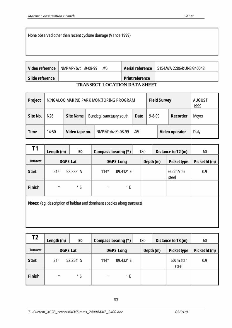
Marine Conservation Branch CALM
T:\Current_MCB_reports\MMS\mms_2400\MMS_2400.doc 05/01/01
53
None observed other than recent cyclone damage (Vance 1999)
Video reference NMPMP/ bvt /9-08-99 /#5 Aerial reference 5154/WA 2286/RUN3/840048
Slide reference Print reference TRANSECT LOCATION DATA SHEET
Project NINGALOO MARINE PARK MONITORING PROGRAM Field Survey AUGUST1999
Site No. N26 Site Name Bundegi, sanctuary south Date 9-8-99 Recorder Meyer
Time 14:50 Video tape no. NMPMP/bvt/9-08-99 /#5 Video operator Daly
T1 Length (m) 50 Compass bearing (°° ) 180 Distance to T2 (m) 60
Transect DGPS Lat DGPS Long Depth (m) Picket type Picket ht (m)
Start 21° 52.222’ S 114° 09.432’ E 60cm Starsteel
0.9
Finish ° ’ S ° ’ E
Notes: (eg. description of habitat and dominant species along transect)
T2 Length (m) 50 Compass bearing (°° ) 180 Distance to T3 (m) 60
Transect DGPS Lat DGPS Long Depth (m) Picket type Picket ht (m)
Start 21° 52.254’ S 114° 09.432’ E 60cm starsteel
0.9
Finish ° ’ S ° ’ E
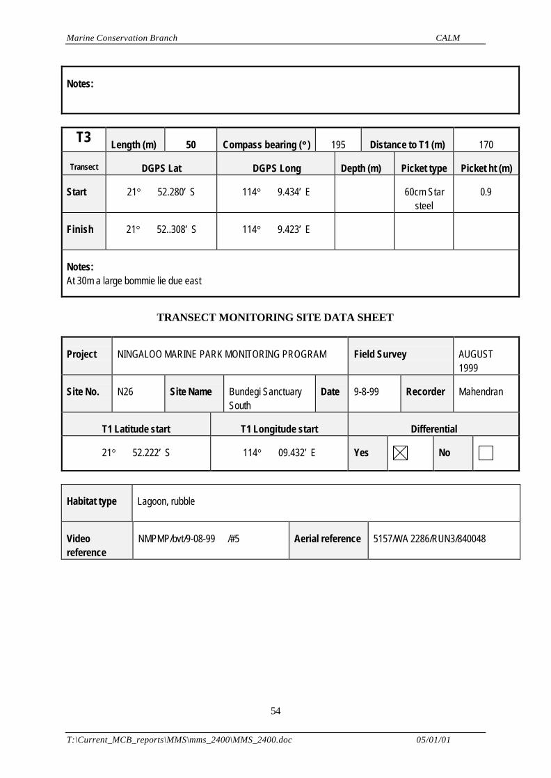
Marine Conservation Branch CALM
T:\Current_MCB_reports\MMS\mms_2400\MMS_2400.doc 05/01/01
54
Notes:
T3 Length (m) 50 Compass bearing (°° ) 195 Distance to T1 (m) 170
Transect DGPS Lat DGPS Long Depth (m) Picket type Picket ht (m)
Start 21° 52.280’ S 114° 9.434’ E 60cm Starsteel
0.9
Finish 21° 52..308’ S 114° 9.423’ E
Notes:At 30m a large bommie lie due east
TRANSECT MONITORING SITE DATA SHEET
Project NINGALOO MARINE PARK MONITORING PROGRAM Field Survey AUGUST1999
Site No. N26 Site Name Bundegi SanctuarySouth
Date 9-8-99 Recorder Mahendran
T1 Latitude start T1 Longitude start Differential
21° 52.222’ S 114° 09.432’ E Yes No
Habitat type Lagoon, rubble
Videoreference
NMPMP/bvt/9-08-99 /#5 Aerial reference 5157/WA 2286/RUN3/840048
Marine Conservation Branch CALM
T:\Current_MCB_reports\MMS\mms_2400\MMS_2400.doc 05/01/01
55
Site Map (include north indicator, scale, start point, water depth, transect locations & other features of interest):
Notes:
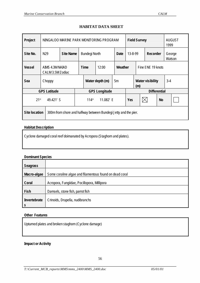
Marine Conservation Branch CALM
T:\Current_MCB_reports\MMS\mms_2400\MMS_2400.doc 05/01/01
56
HABITAT DATA SHEET
Project NINGALOO MARINE PARK MONITORING PROGRAM Field Survey AUGUST1999
Site No. N29 Site Name Bundegi North Date 13-8-99 Recorder GeorgeWatson
Vessel AIMS 4.3M NAIADCALM 3.5M Zodiac
Time 12:00 Weather Fine ENE 19 knots
Sea Choppy Water depth (m) 5m Water visibility(m)
3-4
GPS Latitude GPS Longitude Differential
21° 49.421’ S 114° 11.082’ E Yes No
Site location 300m from shore and halfway between Bundegi Jetty and the pier.
Habitat Description
Cyclone damaged coral reef doimanated by Acropora (Staghorn and plates).
Dominant Species
Seagrass
Macro-algae Some coraline algae and filamentous found on dead coral
Coral Acropora, Fungiidae, Pocillopora, Millipora
Fish Damsels, stone fish, parrot fish
Invertebrates
Crinoids, Drupella, nudibranchs
Other Features
Upturned plates and broken staghorn (Cyclone damage)
Impact or Activity
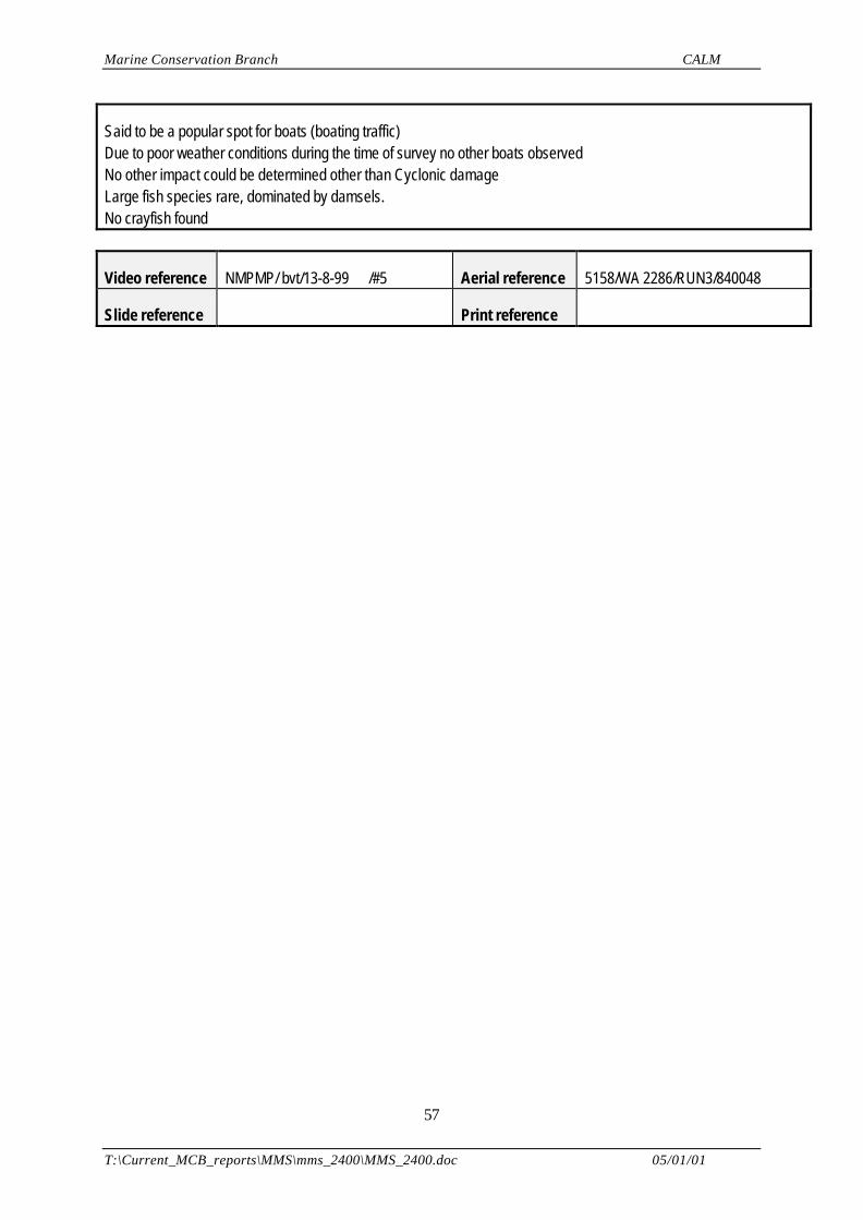
Marine Conservation Branch CALM
T:\Current_MCB_reports\MMS\mms_2400\MMS_2400.doc 05/01/01
57
Said to be a popular spot for boats (boating traffic)Due to poor weather conditions during the time of survey no other boats observedNo other impact could be determined other than Cyclonic damageLarge fish species rare, dominated by damsels.No crayfish found
Video reference NMPMP/ bvt/13-8-99 /#5 Aerial reference 5158/WA 2286/RUN3/840048
Slide reference Print reference
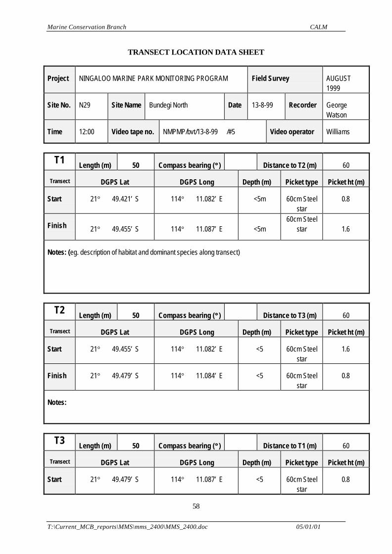
Marine Conservation Branch CALM
T:\Current_MCB_reports\MMS\mms_2400\MMS_2400.doc 05/01/01
58
TRANSECT LOCATION DATA SHEET
Project NINGALOO MARINE PARK MONITORING PROGRAM Field Survey AUGUST1999
Site No. N29 Site Name Bundegi North Date 13-8-99 Recorder GeorgeWatson
Time 12:00 Video tape no. NMPMP/bvt/13-8-99 /#5 Video operator Williams
T1 Length (m) 50 Compass bearing (°° ) Distance to T2 (m) 60
Transect DGPS Lat DGPS Long Depth (m) Picket type Picket ht (m)
Start 21° 49.421’ S 114° 11.082’ E <5m 60cm Steelstar
0.8
Finish 21° 49.455’ S 114° 11.087’ E <5m60cm Steel
star 1.6
Notes: (eg. description of habitat and dominant species along transect)
T2 Length (m) 50 Compass bearing (°° ) Distance to T3 (m) 60
Transect DGPS Lat DGPS Long Depth (m) Picket type Picket ht (m)
Start 21° 49.455’ S 114° 11.082’ E <5 60cm Steelstar
1.6
Finish 21° 49.479’ S 114° 11.084’ E <5 60cm Steelstar
0.8
Notes:
T3 Length (m) 50 Compass bearing (°° ) Distance to T1 (m) 60
Transect DGPS Lat DGPS Long Depth (m) Picket type Picket ht (m)
Start 21° 49.479’ S 114° 11.087’ E <5 60cm Steelstar
0.8
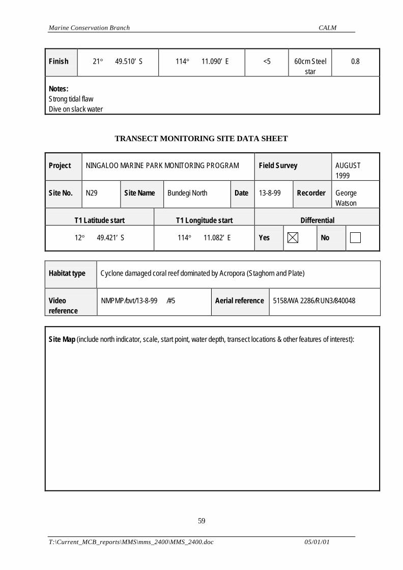
Marine Conservation Branch CALM
T:\Current_MCB_reports\MMS\mms_2400\MMS_2400.doc 05/01/01
59
Finish 21° 49.510’ S 114° 11.090’ E <5 60cm Steelstar
0.8
Notes:Strong tidal flawDive on slack water
TRANSECT MONITORING SITE DATA SHEET
Project NINGALOO MARINE PARK MONITORING PROGRAM Field Survey AUGUST1999
Site No. N29 Site Name Bundegi North Date 13-8-99 Recorder GeorgeWatson
T1 Latitude start T1 Longitude start Differential
12° 49.421’ S 114° 11.082’ E Yes No
Habitat type Cyclone damaged coral reef dominated by Acropora (Staghorn and Plate)
Videoreference
NMPMP/bvt/13-8-99 /#5 Aerial reference 5158/WA 2286/RUN3/840048
Site Map (include north indicator, scale, start point, water depth, transect locations & other features of interest):
Marine Conservation Branch CALM
T:\Current_MCB_reports\MMS\mms_2400\MMS_2400.doc 05/01/01
60
Notes:Strong tidal flow
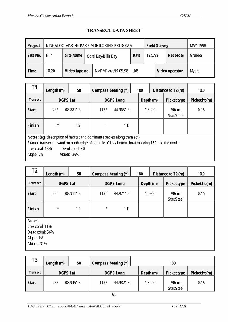
Marine Conservation Branch CALM
T:\Current_MCB_reports\MMS\mms_2400\MMS_2400.doc 05/01/01
61
TRANSECT DATA SHEET
Project NINGALOO MARINE PARK MONITORING PROGRAM Field Survey MAY 1998
Site No. N14 Site Name Coral Bay/Billis Bay Date 19/5/98 Recorder Grubba
Time 10.20 Video tape no. NMPMP/bvt/19.05.98 /#8 Video operator Myers
T1 Length (m) 50 Compass bearing (°° ) 180 Distance to T2 (m) 10.0
Transect DGPS Lat DGPS Long Depth (m) Picket type Picket ht (m)
Start 23° 08.881’ S 113° 44.965’ E 1.5-2.0 90cmStar/Steel
0.15
Finish ° ’ S ° ’ E
Notes: (eg. description of habitat and dominant species along transect)Started transect in sand on north edge of bommie. Glass bottom boat mooring 150m to the north.Live coral: 13% Dead coral: 7%Algae: 0% Abiotic: 26%
T2 Length (m) 50 Compass bearing (°° ) 180 Distance to T2 (m) 10.0
Transect DGPS Lat DGPS Long Depth (m) Picket type Picket ht (m)
Start 23° 08.911’ S 113° 44.971’ E 1.5-2.0 90cmStar/Steel
0.15
Finish ° ’ S ° ’ E
Notes:Live coral: 11% Dead coral: 56%Algae: 1%Abiotic: 31%
T3 Length (m) 50 Compass bearing (°° ) 180
Transect DGPS Lat DGPS Long Depth (m) Picket type Picket ht (m)
Start 23° 08.945’ S 113° 44.982’ E 1.5-2.0 90cmStar/Steel
0.15
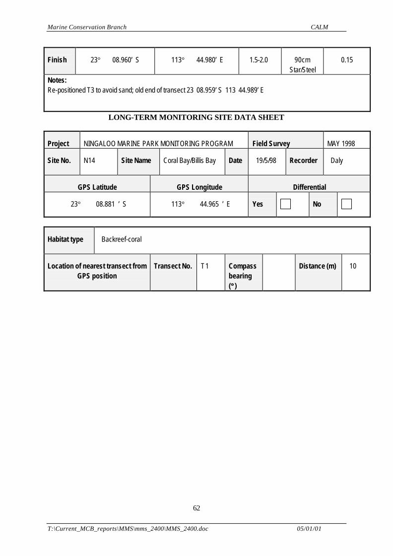
Marine Conservation Branch CALM
T:\Current_MCB_reports\MMS\mms_2400\MMS_2400.doc 05/01/01
62
Finish 23° 08.960’ S 113° 44.980’ E 1.5-2.0 90cmStar/Steel
0.15
Notes:Re-positioned T3 to avoid sand; old end of transect 23 08.959’ S 113 44.989’ E
LONG-TERM MONITORING SITE DATA SHEET
Project NINGALOO MARINE PARK MONITORING PROGRAM Field Survey MAY 1998
Site No. N14 Site Name Coral Bay/Billis Bay Date 19/5/98 Recorder Daly
GPS Latitude GPS Longitude Differential
23° 08.881 ’ S 113° 44.965 ’ E Yes No
Habitat type Backreef-coral
Location of nearest transect fromGPS position
Transect No. T1 Compassbearing(°° )
Distance (m) 10
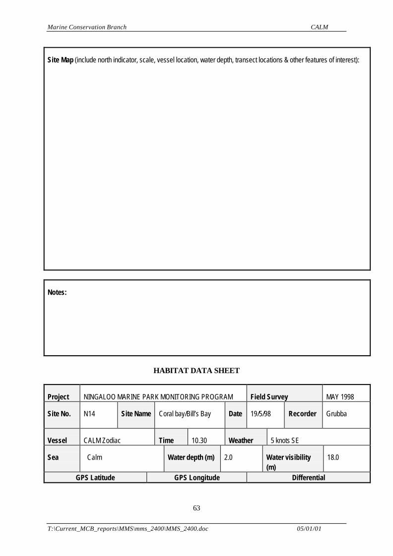
Marine Conservation Branch CALM
T:\Current_MCB_reports\MMS\mms_2400\MMS_2400.doc 05/01/01
63
Site Map (include north indicator, scale, vessel location, water depth, transect locations & other features of interest):
Notes:
HABITAT DATA SHEET
Project NINGALOO MARINE PARK MONITORING PROGRAM Field Survey MAY 1998
Site No. N14 Site Name Coral bay/Bill’s Bay Date 19/5/98 Recorder Grubba
Vessel CALM Zodiac Time 10.30 Weather 5 knots SE
Sea Calm Water depth (m) 2.0 Water visibility(m)
18.0
GPS Latitude GPS Longitude Differential
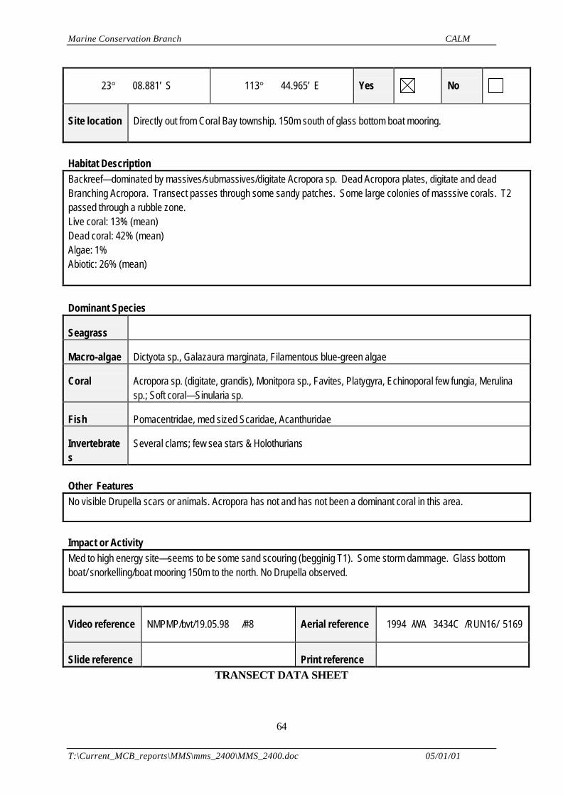
Marine Conservation Branch CALM
T:\Current_MCB_reports\MMS\mms_2400\MMS_2400.doc 05/01/01
64
23° 08.881’ S 113° 44.965’ E Yes No
Site location Directly out from Coral Bay township. 150m south of glass bottom boat mooring.
Habitat DescriptionBackreef—dominated by massives/submassives/digitate Acropora sp. Dead Acropora plates, digitate and deadBranching Acropora. Transect passes through some sandy patches. Some large colonies of masssive corals. T2passed through a rubble zone.Live coral: 13% (mean)Dead coral: 42% (mean)Algae: 1%Abiotic: 26% (mean)
Dominant Species
Seagrass
Macro-algae Dictyota sp., Galazaura marginata, Filamentous blue-green algae
Coral Acropora sp. (digitate, grandis), Monitpora sp., Favites, Platygyra, Echinoporal few fungia, Merulinasp.; Soft coral—Sinularia sp.
Fish Pomacentridae, med sized Scaridae, Acanthuridae
Invertebrates
Several clams; few sea stars & Holothurians
Other FeaturesNo visible Drupella scars or animals. Acropora has not and has not been a dominant coral in this area.
Impact or ActivityMed to high energy site—seems to be some sand scouring (begginig T1). Some storm dammage. Glass bottomboat/ snorkelling/boat mooring 150m to the north. No Drupella observed.
Video reference NMPMP/bvt/19.05.98 /#8 Aerial reference 1994 /WA 3434C /RUN16/ 5169
Slide reference Print reference TRANSECT DATA SHEET
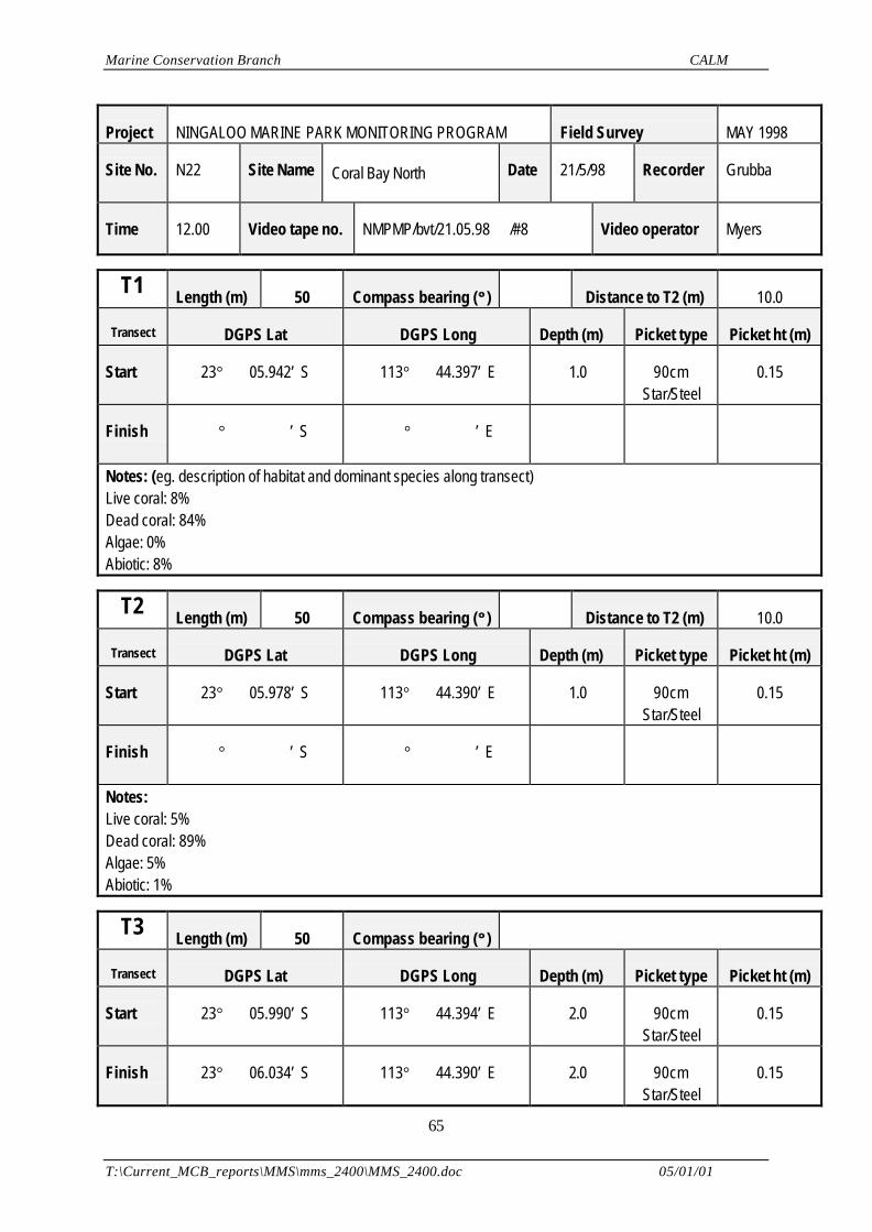
Marine Conservation Branch CALM
T:\Current_MCB_reports\MMS\mms_2400\MMS_2400.doc 05/01/01
65
Project NINGALOO MARINE PARK MONITORING PROGRAM Field Survey MAY 1998
Site No. N22 Site Name Coral Bay North Date 21/5/98 Recorder Grubba
Time 12.00 Video tape no. NMPMP/bvt/21.05.98 /#8 Video operator Myers
T1 Length (m) 50 Compass bearing (°° ) Distance to T2 (m) 10.0
Transect DGPS Lat DGPS Long Depth (m) Picket type Picket ht (m)
Start 23° 05.942’ S 113° 44.397’ E 1.0 90cmStar/Steel
0.15
Finish ° ’ S ° ’ E
Notes: (eg. description of habitat and dominant species along transect)Live coral: 8% Dead coral: 84%Algae: 0%Abiotic: 8%
T2 Length (m) 50 Compass bearing (°° ) Distance to T2 (m) 10.0
Transect DGPS Lat DGPS Long Depth (m) Picket type Picket ht (m)
Start 23° 05.978’ S 113° 44.390’ E 1.0 90cmStar/Steel
0.15
Finish ° ’ S ° ’ E
Notes:Live coral: 5% Dead coral: 89%Algae: 5%Abiotic: 1%
T3 Length (m) 50 Compass bearing (°° )
Transect DGPS Lat DGPS Long Depth (m) Picket type Picket ht (m)
Start 23° 05.990’ S 113° 44.394’ E 2.0 90cmStar/Steel
0.15
Finish 23° 06.034’ S 113° 44.390’ E 2.0 90cmStar/Steel
0.15
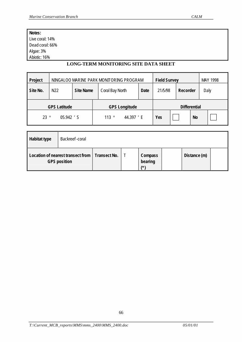
Marine Conservation Branch CALM
T:\Current_MCB_reports\MMS\mms_2400\MMS_2400.doc 05/01/01
66
Notes:Live coral: 14% Dead coral: 66%Algae: 3%Abiotic: 16%
LONG-TERM MONITORING SITE DATA SHEET
Project NINGALOO MARINE PARK MONITORING PROGRAM Field Survey MAY 1998
Site No. N22 Site Name Coral Bay North Date 21/5/98
Recorder Daly
GPS Latitude GPS Longitude Differential
23 ° 05.942 ’ S 113 ° 44.397 ’ E Yes No
Habitat type Backreef -coral
Location of nearest transect fromGPS position
Transect No. T Compassbearing(°° )
Distance (m)

Marine Conservation Branch CALM
T:\Current_MCB_reports\MMS\mms_2400\MMS_2400.doc 05/01/01
67
Site Map (include north indicator, scale, vessel location, water depth, transect locations & other features of interest):
Notes:
HABITAT DATA SHEET
Project NINGALOO MARINE PARK MONITORING PROGRAM Field Survey MAY 1998
Site No. N22 Site Name Coral Bay North Date 21/5/98 Recorder Myers
Vessel CALM Zodiac Time 12.00 Weather S 15 knots
Sea Water depth (m) 2.5 Water visibility(m)
15.0
GPS Latitude GPS Longitude Differential
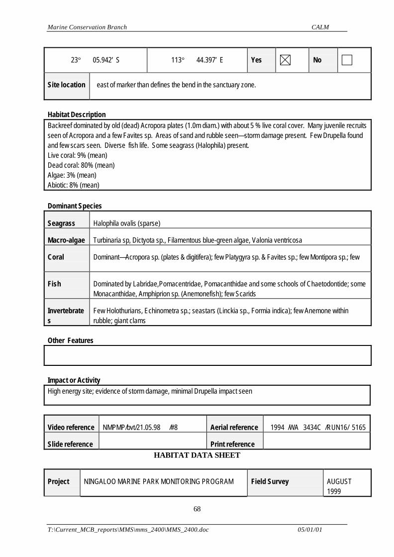
Marine Conservation Branch CALM
T:\Current_MCB_reports\MMS\mms_2400\MMS_2400.doc 05/01/01
68
23° 05.942’ S 113° 44.397’ E Yes No
Site location east of marker than defines the bend in the sanctuary zone.
Habitat DescriptionBackreef dominated by old (dead) Acropora plates (1.0m diam.) with about 5 % live coral cover. Many juvenile recruitsseen of Acropora and a few Favites sp. Areas of sand and rubble seen—storm damage present. Few Drupella foundand few scars seen. Diverse fish life. Some seagrass (Halophila) present.Live coral: 9% (mean)Dead coral: 80% (mean)Algae: 3% (mean)Abiotic: 8% (mean)
Dominant Species
Seagrass Halophila ovalis (sparse)
Macro-algae Turbinaria sp, Dictyota sp., Filamentous blue-green algae, Valonia ventricosa
Coral Dominant—Acropora sp. (plates & digitifera); few Platygyra sp. & Favites sp.; few Montipora sp.; few
Fish Dominated by Labridae,Pomacentridae, Pomacanthidae and some schools of Chaetodontide; someMonacanthidae, Amphiprion sp. (Anemonefish); few Scarids
Invertebrates
Few Holothurians, Echinometra sp.; seastars (Linckia sp., Formia indica); few Anemone withinrubble; giant clams
Other Features
Impact or ActivityHigh energy site; evidence of storm damage, minimal Drupella impact seen
Video reference NMPMP/bvt/21.05.98 /#8 Aerial reference 1994 /WA 3434C /RUN16/ 5165
Slide reference Print reference HABITAT DATA SHEET
Project NINGALOO MARINE PARK MONITORING PROGRAM Field Survey AUGUST1999
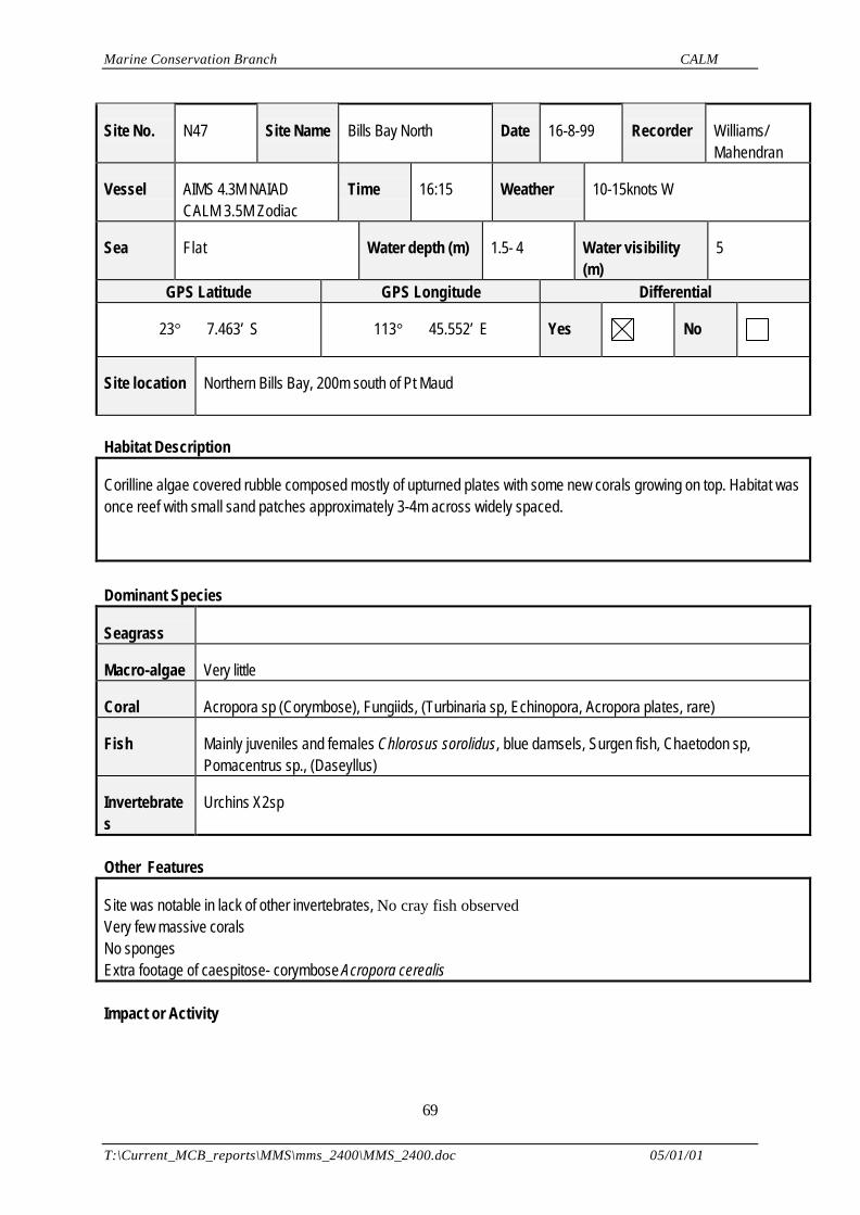
Marine Conservation Branch CALM
T:\Current_MCB_reports\MMS\mms_2400\MMS_2400.doc 05/01/01
69
Site No. N47 Site Name Bills Bay North Date 16-8-99 Recorder Williams/Mahendran
Vessel AIMS 4.3M NAIADCALM 3.5M Zodiac
Time 16:15 Weather 10-15knots W
Sea Flat Water depth (m) 1.5- 4 Water visibility(m)
5
GPS Latitude GPS Longitude Differential
23° 7.463’ S 113° 45.552’ E Yes No
Site location Northern Bills Bay, 200m south of Pt Maud
Habitat Description
Corilline algae covered rubble composed mostly of upturned plates with some new corals growing on top. Habitat wasonce reef with small sand patches approximately 3-4m across widely spaced.
Dominant Species
Seagrass
Macro-algae Very little
Coral Acropora sp (Corymbose), Fungiids, (Turbinaria sp, Echinopora, Acropora plates, rare)
Fish Mainly juveniles and females Chlorosus sorolidus, blue damsels, Surgen fish, Chaetodon sp,Pomacentrus sp., (Daseyllus)
Invertebrates
Urchins X2sp
Other Features
Site was notable in lack of other invertebrates, No cray fish observedVery few massive coralsNo spongesExtra footage of caespitose- corymbose Acropora cerealis
Impact or Activity
Marine Conservation Branch CALM
T:\Current_MCB_reports\MMS\mms_2400\MMS_2400.doc 05/01/01
70
Rubble caused by (unknown factor) possibly cyclone (not Vance)Site very rarely visited by anyone due to shallow location in Sanctuary zone.
Video reference NMPMP/ bvt /16-8-99 /#6 Aerial reference DMS 612
Slide reference Print reference TRANSECT LOCATION DATA SHEET
Project NINGALOO MARINE PARK MONITORING PROGRAM Field Survey AUGUST1999
Site No. N47 Site Name Bills Bay North Date 16-8-99 Recorder Daly/ Myer
Time 14:15 Video tape no. NMPMP/bvt/16-8-99 /#6 Video operator Williams
T1 Length (m) 50 Compass bearing (°° ) 180 Distance to T2 (m) 60
Transect DGPS Lat DGPS Long Depth (m) Picket type Picket ht (m)
Start 23° 7.463’ S 113° 45.552’ E 4m 90cm Starsteel
0.25
Finish ° ’ S ° ’ E
Notes: (eg. description of habitat and dominant species along transect)Rubble over dead shallow bommies (1.5m) down to small sand patches on floor (at 4m)
T2 Length (m) 50 Compass bearing (°° ) 180 Distance to T3 (m) 60
Transect DGPS Lat DGPS Long Depth (m) Picket type Picket ht (m)
Start 23° 7.493’ S 113° 45.536’ E 3.5 90cm Starsteel
0.25
Finish ° ’ S ° ’ E
Marine Conservation Branch CALM
T:\Current_MCB_reports\MMS\mms_2400\MMS_2400.doc 05/01/01
71
Notes:
T3 Length (m) 50 Compass bearing (°° ) 180 Distance to T1 (m) 170
Transect DGPS Lat DGPS Long Depth (m) Picket type Picket ht (m)
Start 23° 7.523’ S 113° 45.538’ E 3m 90cm Starsteel
0.25
Finish 23° 7.549’ S 113° 45.534’ E 2m 150cm Starsteel
0.25
Notes:
TRANSECT MONITORING SITE DATA SHEET
Project NINGALOO MARINE PARK MONITORING PROGRAM Field Survey AUGUST1999
Site No. N47 Site Name Bills Bay North Date 16-8-99 Recorder Daly/ Myer
T1 Latitude start T1 Longitude start Differential
23° 7.463’ S 113° 45.552’ E Yes No
Habitat type Coraline algae covered rubble composed mostly of upturned plates with some new corals growingon top. Habitat was once reef with small sand patches approximately 3-4m across widely spaced.
Videoreference
NMPMP/bvt /16-8-99 /#6 Aerial reference DMH 612
Marine Conservation Branch CALM
T:\Current_MCB_reports\MMS\mms_2400\MMS_2400.doc 05/01/01
72
Site Map (include north indicator, scale, start point, water depth, transect locations & other features of interest):
Drawn to scale 0.325 from DMH612
Notes:Access from Southern Bill’s Bay, path across the reef is strongly discouraged by CALM rangers and locals.
Marine Conservation Branch CALM
T:\Current_MCB_reports\MMS\mms_2400\MMS_2400.doc 05/01/01
73
HABITAT DATA SHEET
Project NINGALOO MARINE PARK MONITORING PROGRAM Field Survey AUGUST1999
Site No. N48 Site Name Bills Bay South Date 19-8-99 Recorder WilliamsMahendran
Vessel AIMS 4.3M NAIADCALM 3.5M Zodiac
Time 14:40 Weather 19 knots SW
Sea Slight current Water depth (m) 2-3m Water visibility(m)
8M
GPS Latitude GPS Longitude Differential
23° 8.476’ S 113° 46.163’ E Yes No
Site location This site is adjacent to the Coral Bay boat launching area in Bills BayApproximately 2km south of Pt Maud
Habitat Description
Coral rubble with Montipora and branching Acropora.
Dominant Species
Seagrass
Macro-algae
Coral Montipora, Branching Acropora, Echinopora (moderate), (Fungids, Pocillopora, rare)
Fish Wrasse, black and white Dacycallus, Blue Damsels, Angel fish, Chaethodon, Five lined seaperch
Invertebrates
Oyster
Other Features
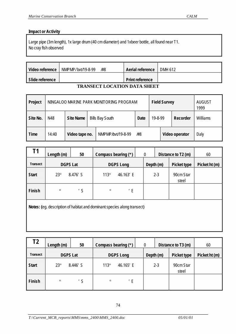
Marine Conservation Branch CALM
T:\Current_MCB_reports\MMS\mms_2400\MMS_2400.doc 05/01/01
74
Impact or Activity
Large pipe (3m length), 1x large drum (40 cm diameter) and 1xbeer bottle, all found near T1.No cray fish observed
Video reference NMPMP/ bvt/19-8-99 /#8 Aerial reference DMH 612
Slide reference Print reference TRANSECT LOCATION DATA SHEET
Project NINGALOO MARINE PARK MONITORING PROGRAM Field Survey AUGUST1999
Site No. N48 Site Name Bills Bay South Date 19-8-99 Recorder Williams
Time 14:40 Video tape no. NMPMP/bvt/19-8-99 /#8 Video operator Daly
T1 Length (m) 50 Compass bearing (°° ) 0 Distance to T2 (m) 60
Transect DGPS Lat DGPS Long Depth (m) Picket type Picket ht (m)
Start 23° 8.476’ S 113° 46.163’ E 2-3 90cm Starsteel
Finish ° ’ S ° ’ E
Notes: (eg. description of habitat and dominant species along transect)
T2 Length (m) 50 Compass bearing (°° ) 0 Distance to T3 (m) 60
Transect DGPS Lat DGPS Long Depth (m) Picket type Picket ht (m)
Start 23° 8.446’ S 113° 46.165’ E 2-3 90cm Starsteel
Finish ° ’ S ° ’ E
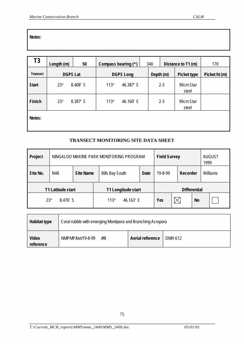
Marine Conservation Branch CALM
T:\Current_MCB_reports\MMS\mms_2400\MMS_2400.doc 05/01/01
75
Notes:
T3 Length (m) 50 Compass bearing (°° ) 340 Distance to T1 (m) 170
Transect DGPS Lat DGPS Long Depth (m) Picket type Picket ht (m)
Start 23° 8.408’ S 113° 46.387’ E 2-3 90cm Starsteel
Finish 23° 8.387’ S 113° 46.160’ E 2-3 90cm Starsteel
Notes:
TRANSECT MONITORING SITE DATA SHEET
Project NINGALOO MARINE PARK MONITORING PROGRAM Field Survey AUGUST1999
Site No. N48 Site Name Bills Bay South Date 19-8-99 Recorder Williams
T1 Latitude start T1 Longitude start Differential
23° 8.476’ S 113° 46.163’ E Yes No
Habitat type Coral rubble with emerging Montipora and Branching Acropora
Videoreference
NMPMP/bvt/19-8-99 /#8 Aerial reference DMH 612
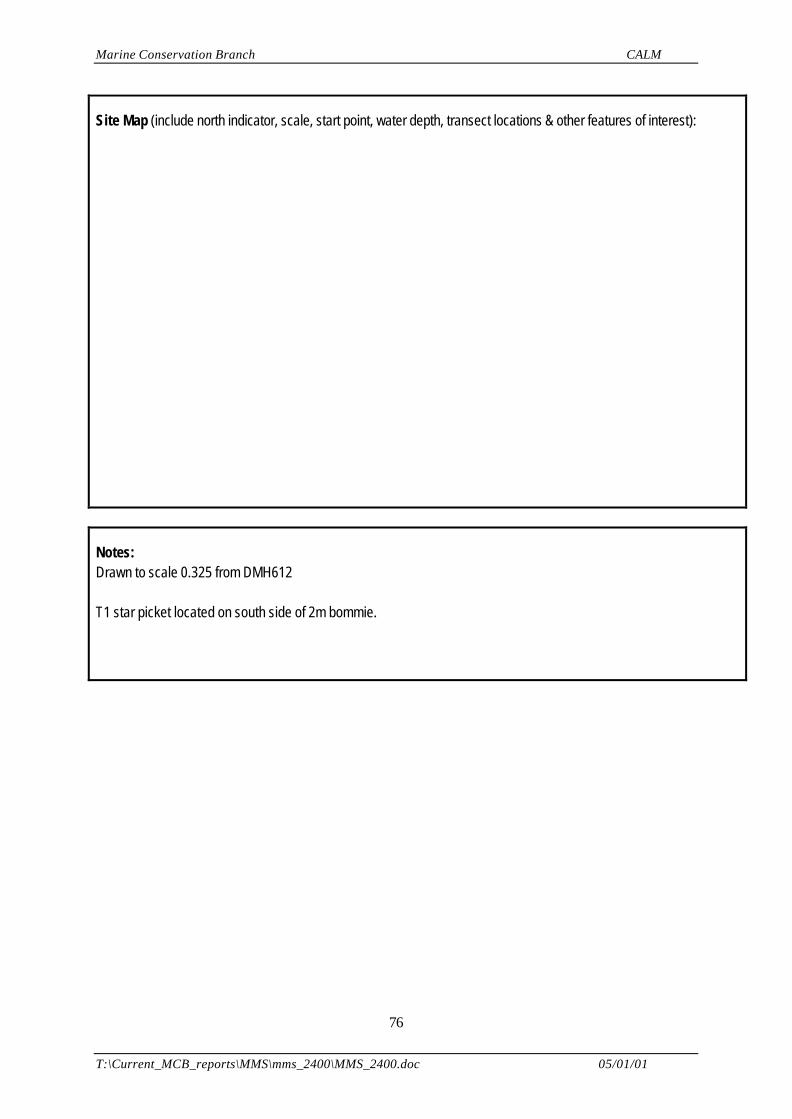
Marine Conservation Branch CALM
T:\Current_MCB_reports\MMS\mms_2400\MMS_2400.doc 05/01/01
76
Site Map (include north indicator, scale, start point, water depth, transect locations & other features of interest):
Notes:Drawn to scale 0.325 from DMH612
T1 star picket located on south side of 2m bommie.
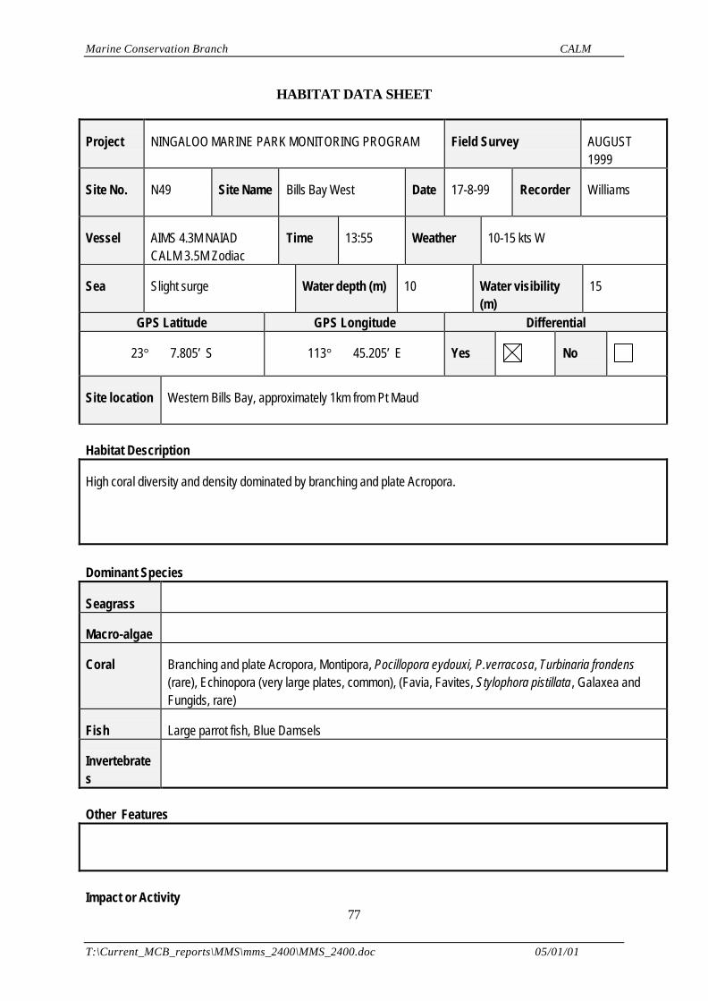
Marine Conservation Branch CALM
T:\Current_MCB_reports\MMS\mms_2400\MMS_2400.doc 05/01/01
77
HABITAT DATA SHEET
Project NINGALOO MARINE PARK MONITORING PROGRAM Field Survey AUGUST1999
Site No. N49 Site Name Bills Bay West Date 17-8-99 Recorder Williams
Vessel AIMS 4.3M NAIADCALM 3.5M Zodiac
Time 13:55 Weather 10-15 kts W
Sea Slight surge Water depth (m) 10 Water visibility(m)
15
GPS Latitude GPS Longitude Differential
23° 7.805’ S 113° 45.205’ E Yes No
Site location Western Bills Bay, approximately 1km from Pt Maud
Habitat Description
High coral diversity and density dominated by branching and plate Acropora.
Dominant Species
Seagrass
Macro-algae
Coral Branching and plate Acropora, Montipora, Pocillopora eydouxi, P.verracosa, Turbinaria frondens(rare), Echinopora (very large plates, common), (Favia, Favites, Stylophora pistillata, Galaxea andFungids, rare)
Fish Large parrot fish, Blue Damsels
Invertebrates
Other Features
Impact or Activity
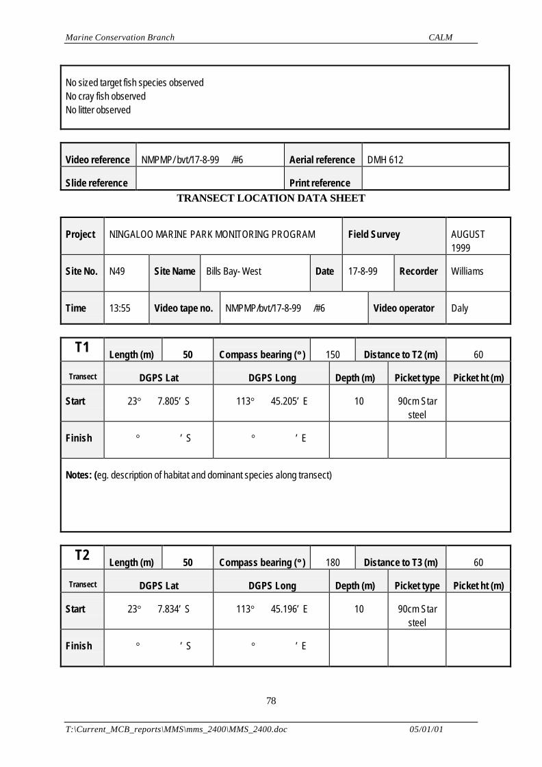
Marine Conservation Branch CALM
T:\Current_MCB_reports\MMS\mms_2400\MMS_2400.doc 05/01/01
78
No sized target fish species observedNo cray fish observedNo litter observed
Video reference NMPMP/ bvt/17-8-99 /#6 Aerial reference DMH 612
Slide reference Print reference TRANSECT LOCATION DATA SHEET
Project NINGALOO MARINE PARK MONITORING PROGRAM Field Survey AUGUST1999
Site No. N49 Site Name Bills Bay- West Date 17-8-99 Recorder Williams
Time 13:55 Video tape no. NMPMP/bvt/17-8-99 /#6 Video operator Daly
T1 Length (m) 50 Compass bearing (°° ) 150 Distance to T2 (m) 60
Transect DGPS Lat DGPS Long Depth (m) Picket type Picket ht (m)
Start 23° 7.805’ S 113° 45.205’ E 10 90cm Starsteel
Finish ° ’ S ° ’ E
Notes: (eg. description of habitat and dominant species along transect)
T2 Length (m) 50 Compass bearing (°° ) 180 Distance to T3 (m) 60
Transect DGPS Lat DGPS Long Depth (m) Picket type Picket ht (m)
Start 23° 7.834’ S 113° 45.196’ E 10 90cm Starsteel
Finish ° ’ S ° ’ E
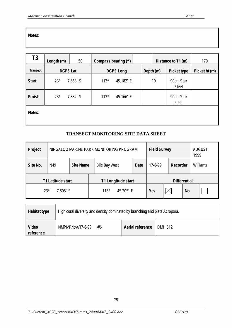
Marine Conservation Branch CALM
T:\Current_MCB_reports\MMS\mms_2400\MMS_2400.doc 05/01/01
79
Notes:
T3 Length (m) 50 Compass bearing (°° ) Distance to T1 (m) 170
Transect DGPS Lat DGPS Long Depth (m) Picket type Picket ht (m)
Start 23° 7.863’ S 113° 45.182’ E 10 90cm StarSteel
Finish 23° 7.882’ S 113° 45.166’ E 90cm Starsteel
Notes:
TRANSECT MONITORING SITE DATA SHEET
Project NINGALOO MARINE PARK MONITORING PROGRAM Field Survey AUGUST1999
Site No. N49 Site Name Bills Bay West Date 17-8-99 Recorder Williams
T1 Latitude start T1 Longitude start Differential
23° 7.805’ S 113° 45.205’ E Yes No
Habitat type High coral diversity and density dominated by branching and plate Acropora.
Videoreference
NMPMP/ bvt/17-8-99 /#6 Aerial reference DMH 612
Marine Conservation Branch CALM
T:\Current_MCB_reports\MMS\mms_2400\MMS_2400.doc 05/01/01
80
Site Map (include north indicator, scale, start point, water depth, transect locations & other features of interest):
Notes:Drawn to scale 0.325 from DMH612
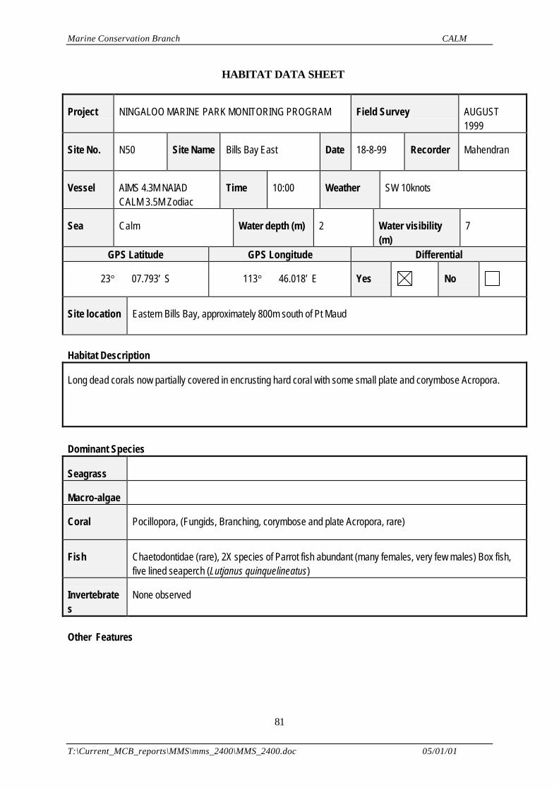
Marine Conservation Branch CALM
T:\Current_MCB_reports\MMS\mms_2400\MMS_2400.doc 05/01/01
81
HABITAT DATA SHEET
Project NINGALOO MARINE PARK MONITORING PROGRAM Field Survey AUGUST1999
Site No. N50 Site Name Bills Bay East Date 18-8-99 Recorder Mahendran
Vessel AIMS 4.3M NAIADCALM 3.5M Zodiac
Time 10:00 Weather SW 10knots
Sea Calm Water depth (m) 2 Water visibility(m)
7
GPS Latitude GPS Longitude Differential
23° 07.793’ S 113° 46.018’ E Yes No
Site location Eastern Bills Bay, approximately 800m south of Pt Maud
Habitat Description
Long dead corals now partially covered in encrusting hard coral with some small plate and corymbose Acropora.
Dominant Species
Seagrass
Macro-algae
Coral Pocillopora, (Fungids, Branching, corymbose and plate Acropora, rare)
Fish Chaetodontidae (rare), 2X species of Parrot fish abundant (many females, very few males) Box fish,five lined seaperch (Lutjanus quinquelineatus)
Invertebrates
None observed
Other Features
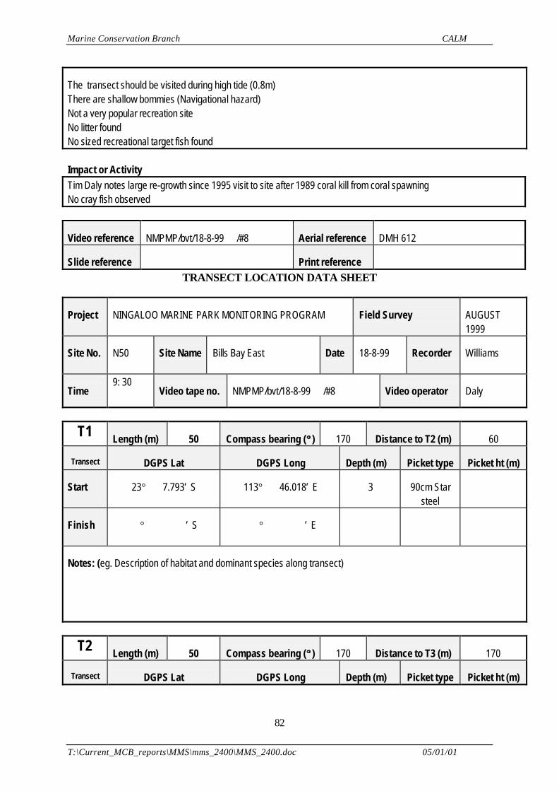
Marine Conservation Branch CALM
T:\Current_MCB_reports\MMS\mms_2400\MMS_2400.doc 05/01/01
82
The transect should be visited during high tide (0.8m)There are shallow bommies (Navigational hazard)Not a very popular recreation siteNo litter foundNo sized recreational target fish found
Impact or ActivityTim Daly notes large re-growth since 1995 visit to site after 1989 coral kill from coral spawningNo cray fish observed
Video reference NMPMP/bvt/18-8-99 /#8 Aerial reference DMH 612
Slide reference Print reference TRANSECT LOCATION DATA SHEET
Project NINGALOO MARINE PARK MONITORING PROGRAM Field Survey AUGUST1999
Site No. N50 Site Name Bills Bay East Date 18-8-99 Recorder Williams
Time9: 30
Video tape no. NMPMP/bvt/18-8-99 /#8 Video operator Daly
T1 Length (m) 50 Compass bearing (°° ) 170 Distance to T2 (m) 60
Transect DGPS Lat DGPS Long Depth (m) Picket type Picket ht (m)
Start 23° 7.793’ S 113° 46.018’ E 3 90cm Starsteel
Finish ° ’ S ° ’ E
Notes: (eg. Description of habitat and dominant species along transect)
T2 Length (m) 50 Compass bearing (°° ) 170 Distance to T3 (m) 170
Transect DGPS Lat DGPS Long Depth (m) Picket type Picket ht (m)
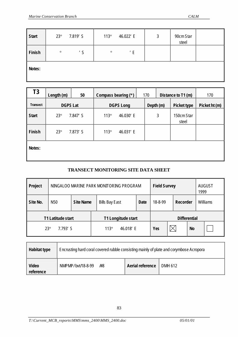
Marine Conservation Branch CALM
T:\Current_MCB_reports\MMS\mms_2400\MMS_2400.doc 05/01/01
83
Start 23° 7.819’ S 113° 46.022’ E 3 90cm Starsteel
Finish ° ’ S ° ’ E
Notes:
T3 Length (m) 50 Compass bearing (°° ) 170 Distance to T1 (m) 170
Transect DGPS Lat DGPS Long Depth (m) Picket type Picket ht (m)
Start 23° 7.847’ S 113° 46.030’ E 3 150cm Starsteel
Finish 23° 7.873’ S 113° 46.031’ E
Notes:
TRANSECT MONITORING SITE DATA SHEET
Project NINGALOO MARINE PARK MONITORING PROGRAM Field Survey AUGUST1999
Site No. N50 Site Name Bills Bay East Date 18-8-99 Recorder Williams
T1 Latitude start T1 Longitude start Differential
23° 7.793’ S 113° 46.018’ E Yes No
Habitat type Encrusting hard coral covered rubble consisting mainly of plate and corymbose Acropora
Videoreference
NMPMP/ bvt/18-8-99 /#8 Aerial reference DMH 612
Marine Conservation Branch CALM
T:\Current_MCB_reports\MMS\mms_2400\MMS_2400.doc 05/01/01
84
Site Map (include north indicator, scale, start point, water depth, transect locations & other features of interest):
Drawn to scale 0.325 from DMH612
Notes:Shallow site, requires 0.8m minimum tide for safe navigation
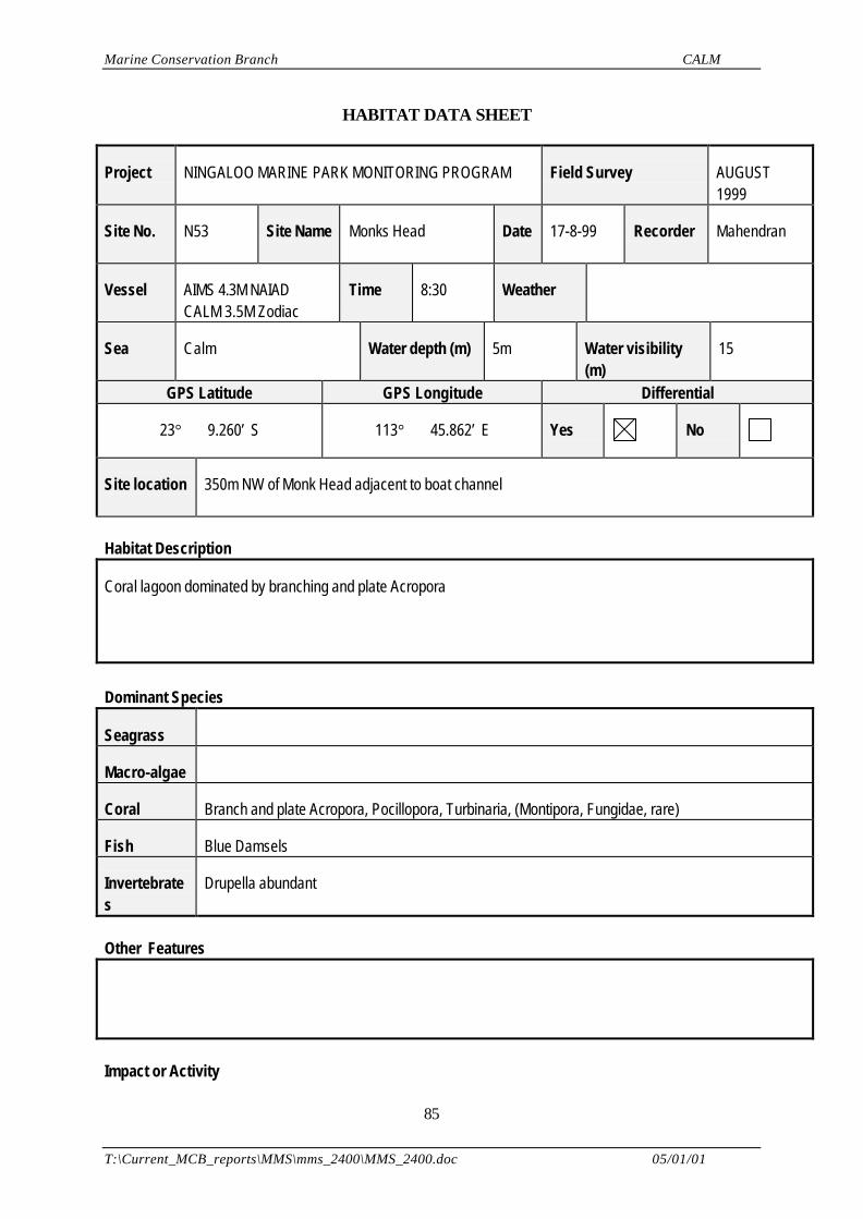
Marine Conservation Branch CALM
T:\Current_MCB_reports\MMS\mms_2400\MMS_2400.doc 05/01/01
85
HABITAT DATA SHEET
Project NINGALOO MARINE PARK MONITORING PROGRAM Field Survey AUGUST1999
Site No. N53 Site Name Monks Head Date 17-8-99 Recorder Mahendran
Vessel AIMS 4.3M NAIADCALM 3.5M Zodiac
Time 8:30 Weather
Sea Calm Water depth (m) 5m Water visibility(m)
15
GPS Latitude GPS Longitude Differential
23° 9.260’ S 113° 45.862’ E Yes No
Site location 350m NW of Monk Head adjacent to boat channel
Habitat Description
Coral lagoon dominated by branching and plate Acropora
Dominant Species
Seagrass
Macro-algae
Coral Branch and plate Acropora, Pocillopora, Turbinaria, (Montipora, Fungidae, rare)
Fish Blue Damsels
Invertebrates
Drupella abundant
Other Features
Impact or Activity
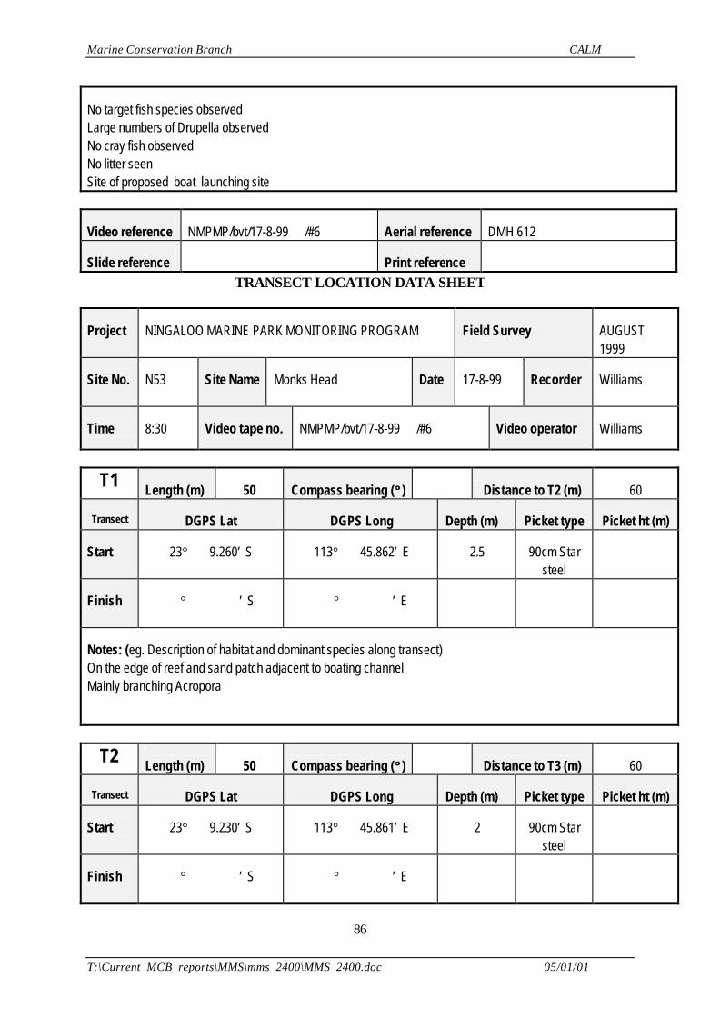
Marine Conservation Branch CALM
T:\Current_MCB_reports\MMS\mms_2400\MMS_2400.doc 05/01/01
86
No target fish species observedLarge numbers of Drupella observedNo cray fish observedNo litter seenSite of proposed boat launching site
Video reference NMPMP/bvt/17-8-99 /#6 Aerial reference DMH 612
Slide reference Print reference TRANSECT LOCATION DATA SHEET
Project NINGALOO MARINE PARK MONITORING PROGRAM Field Survey AUGUST1999
Site No. N53 Site Name Monks Head Date 17-8-99 Recorder Williams
Time 8:30 Video tape no. NMPMP/bvt/17-8-99 /#6 Video operator Williams
T1 Length (m) 50 Compass bearing (°° ) Distance to T2 (m) 60
Transect DGPS Lat DGPS Long Depth (m) Picket type Picket ht (m)
Start 23° 9.260’ S 113° 45.862’ E 2.5 90cm Starsteel
Finish ° ’ S ° ’ E
Notes: (eg. Description of habitat and dominant species along transect)On the edge of reef and sand patch adjacent to boating channelMainly branching Acropora
T2 Length (m) 50 Compass bearing (°° ) Distance to T3 (m) 60
Transect DGPS Lat DGPS Long Depth (m) Picket type Picket ht (m)
Start 23° 9.230’ S 113° 45.861’ E 2 90cm Starsteel
Finish ° ’ S ° ’ E
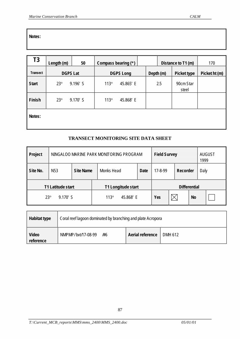
Marine Conservation Branch CALM
T:\Current_MCB_reports\MMS\mms_2400\MMS_2400.doc 05/01/01
87
Notes:
T3 Length (m) 50 Compass bearing (°° ) Distance to T1 (m) 170
Transect DGPS Lat DGPS Long Depth (m) Picket type Picket ht (m)
Start 23° 9.196’ S 113° 45.865’ E 2.5 90cm Starsteel
Finish 23° 9.170’ S 113° 45.868’ E
Notes:
TRANSECT MONITORING SITE DATA SHEET
Project NINGALOO MARINE PARK MONITORING PROGRAM Field Survey AUGUST1999
Site No. N53 Site Name Monks Head Date 17-8-99 Recorder Daly
T1 Latitude start T1 Longitude start Differential
23° 9.170’ S 113° 45.868’ E Yes No
Habitat type Coral reef lagoon dominated by branching and plate Acropora
Videoreference
NMPMP/ bvt/17-08-99 /#6 Aerial reference DMH 612
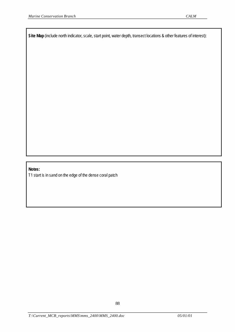
Marine Conservation Branch CALM
T:\Current_MCB_reports\MMS\mms_2400\MMS_2400.doc 05/01/01
88
Site Map (include north indicator, scale, start point, water depth, transect locations & other features of interest):
Notes:T1 start is in sand on the edge of the dense coral patch