Embed Size (px)
Citation preview
GEOLOGICAL SURVEY OF ALABAMA
Berry H. (Nick) Tew, Jr. State Geologist
WATER INVESTIGATIONS PROGRAM
Patrick E. O’Neil Director
RESULTS OF QUALITATIVE SAMPLING FOR PROTECTED MUSSEL SPECIES AT SELECTED STATIONS IN THE
CAHABA AND COOSA RIVERS, ALABAMA, 2004
OPEN-FILE REPORT 0505
By
Stuart W. McGregor1 and Jeffrey T. Garner2
1Geological Survey of Alabama, Water Investigations Program 2Alabama Department of Conservation and Natural Resources,
Division of Wildlife and Freshwater Fisheries
A cooperative effort of the Geological Survey of Alabama and the Alabama Department of Conservation and Natural Resources, Division of Wildlife and Freshwater Fisheries
Tuscaloosa, Alabama 2004
CONTENTS Page Abstract .......................................................................................................................... 1 Introduction.................................................................................................................... 1 Acknowledgments.......................................................................................................... 3 Study area....................................................................................................................... 3 Methods.......................................................................................................................... 3 Results............................................................................................................................ 6 Coosa River.............................................................................................................. 6 Cahaba River............................................................................................................ 10 Discussion and Recommendations ................................................................................ 15 References cited ............................................................................................................. 17
ILLUSTRATIONS Figure 1. Sampling stations in the Coosa River, 2004................................................... 4 Figure 2. Sampling stations in the Cahaba River system, 2004..................................... 5
TABLES Table 1. Summary information for mussel sampling stations in the Coosa River,
Alabama, 2004 ................................................................................................... 7 Table 2. Summary information for mussel species collected in the Coosa River, Alabama, 2004 ................................................................................................... 9 Table 3. Summary information for mussel sampling stations in the Cahaba River, Alabama, 2004 ................................................................................................... 11 Table 4. Summary information for mussel species collected in the Cahaba River system, Alabama, 2004 ...................................................................................... 13
RESULTS OF QUALITATIVE SAMPLING FOR PROTECTED MUSSEL SPECIES AT SELECTED STATIONS IN THE
CAHABA AND COOSA RIVERS, ALABAMA, 2004 by
Stuart W. McGregor and Jeffrey T. Garner
ABSTRACT Freshwater mussel (Bivalvia: Unionidae) populations were surveyed in the
riverine reaches of Coosa River downstream of H. Neely Henry, Lay, Logan Martin, and Mitchell Dams, Lay and H. Neely Henry Reservoirs, and at selected stations in the Cahaba River system. In the Coosa River, approximately 21 hours of bottom time were logged using surface air source at 20 stations. Twenty-three species of mussels were collected, including 19 species found live or fresh dead and 4 species as weathered dead or relic shells only. One federally listed endangered species was encountered, the Southern Clubshell, Pleurobema decisum (2 live animals and several relic shells). Most species encountered were uncommon to rare, and three species accounted for 84 percent of the total catch of live and fresh dead mussels. Obliquaria reflexa (17 percent) was the only species found in all reaches sampled, while Quadrula apiculata (55.7 percent) was missing only from H. Neely Henry Reservoir. Many species historically known from the Coosa River in this vicinity have apparently been extirpated. In the Cahaba River, about 54.8 person hours was expended using mask and snorkel and visual searches at 15 stations and 25 species of mussels were collected, including 22 species found live or fresh dead and 3 species as weathered dead or relic shells only. Three federally listed endangered or threatened species were encountered, including the Finelined Pocketbook, Lampsilis altilis (18 live); Ovate Clubshell, Pleurobema perovatum (1 live); and Triangular Kidneyshell, Ptychobranchus greenii (15 live). One species, the Elephant Ear, Elliptio crassidens, accounted for 56.1 percent of the total collected live or fresh dead, and 15 species accounted for less than 1 percent each. The Ovate Clubshell has not been reported from the Cahaba River system since the early 1930s, and the Triangular Kidneyshell was last reported in the early 1990s.
INTRODUCTION Seventeen species of freshwater mussels historically known from the Mobile
River basin are currently listed as endangered or threatened by the U.S. Fish and Wildlife Service. The decline of the mussel fauna is due to the collective effects of impoundment, sedimentation, eutrophication, pollution, channel modification, and urbanization (Bogan, 1993; Hartfield, 1994; Gangloff and Feminella, in press). Other factors affecting the distribution and abundance of freshwater mussels in North America include possible competition by exotic species such as the Asian clam, Corbicula fluminea, and the zebra mussel, Dreissena polymorpha. The Asian clam is known to compete with native mussels for space and food resources and has occupied streams in the Mobile River Basin since the mid-20th century. The Zebra mussel had a well-documented and profound affect in a very short time on native mussel populations in northern lakes and rivers in the United States and Canada but has not been reported from the Mobile River Basin.
1
Impoundment of the Coosa River primary channel is believed to have caused one of the most significant extinction events in modern times. The Coosa River system historically supported 64 species of mussels (Feminella and Gangloff, 2000), but only 45 (38 live) were reported from surveys in 1972 (Hurd, 1974). There have been no extensive surveys, using diving equipment, of the riverine reaches of Coosa River since construction of the dams; consequently, little is known about the current distribution of mussels in the Coosa River primary channel. Previous documentation of the mussel and snail faunas was based on collections by H. H. Smith and A. A. Hinkley (van der Schalie, 1981) prior to construction of impoundments and by Basch (1959), Hurd (1974), Bogan and Pierson (1993), and Herod and others (2001) post impoundment.
Numerous studies of the Cahaba River mollusk fauna and the river’s water-quality have been published through the years. Lewis (1876) cataloged many freshwater and land shells of Alabama, including numerous species of freshwater mussels from the Cahaba River reported by various collectors. His locality information was vague, but it included species listed from the Cahaba River drainage specifically and the Alabama River system generally. Other authors, including Johnson (1967), Frey and others (1976), and Stansbery (1983a, b, c) have reported other mussel records from the Cahaba River. However, only three comprehensive mussel surveys of the drainage have been completed to date, the most recent documenting survey efforts approximately a decade ago (van der Schalie, 1938; Baldwin, 1973; McGregor and others, 2000).
In a report on freshwater mussels collected in the Cahaba River system in 1933 and 1935, van der Schalie (1938) stated that the Cahaba River was "unusually productive conchologically,” yielding 42 species in 23 genera from 34 stations in the system. He reported that the most prominent dangers to the Cahaba River mussel fauna were the possibility of pollution by acid-containing mine wastes, heavy concentrations of industrial wastes and sewage from Birmingham, and the disturbance of the natural conditions in the river by dam construction.
In a study of the changes in the Cahaba River mussel fauna over a 40-year period, Baldwin (1973) reported 31 species in 21 genera from 19 stations. He reported that 12 species had increased in abundance and 34 species had decreased in abundance during that time period. Baldwin (1973) supported van der Schalie's (1938) predictions regarding potential impacts to the mussel fauna of the Cahaba River. He also commented that pollution from coal fields and strip mining had caused considerable acid run-off, and housing developments near the river in Birmingham had increased by twofold the amount of waste entering the river from the time of van der Schalie's (1938) study.
Collections from the early 1990s (McGregor and others, 2000) documented 23 species of native freshwater mussels in 17 genera and Corbicula in the Cahaba River downstream of Centreville in 45 collections. The first record from the Cahaba River system for one species, Plectomerus dombeyanus, was reported. Fresh dead specimens of threatened Lampsilis altilis and endangered Ptychobranchus greenii and relic specimens of endangered Pleurobema decisum were reported during field effort for that study. The status of all freshwater mussel species known from the Cahaba River system at that time was discussed. A cumulative total of 43 species in 25 genera (adjusted to Turgeon and others, 1998) are reported from the drainage from 1933 to 1994 (McGregor and others, 2000).
2
The primary objective of this study was to survey riverine reaches of the Coosa River downstream of dams and the Cahaba River and tributaries for federally listed mussel species. Secondary objectives included finding potential sources of broodstock for culture of listed species for eventual release and to determine other likely reintroduction locations within the historic ranges of listed mussels. A third objective was to document the current composition of the mussel fauna within the study area.
ACKNOWLEDGMENTS Gratitude is extended to Sandy Pursifull of Alabama Department of Environmental Management, Mike Gangloff of Auburn University, Paul Freeman of The Nature Conservancy, Randall Haddock of The Cahaba River Society, and Jeffrey Sides of The Tennessee Aquarium Research Institute for assistance with field collections. Phillip Henderson of the Geological Survey of Alabama created the figures used in this report. The Presbytery of Sheppards and Lapsley (Presbyterian Church, USA) graciously permitted access to the Cahaba River across its property. This project was supported by Alabama Department of Conservation and Natural Resources with funds from Section 6 of the Endangered Species Act.
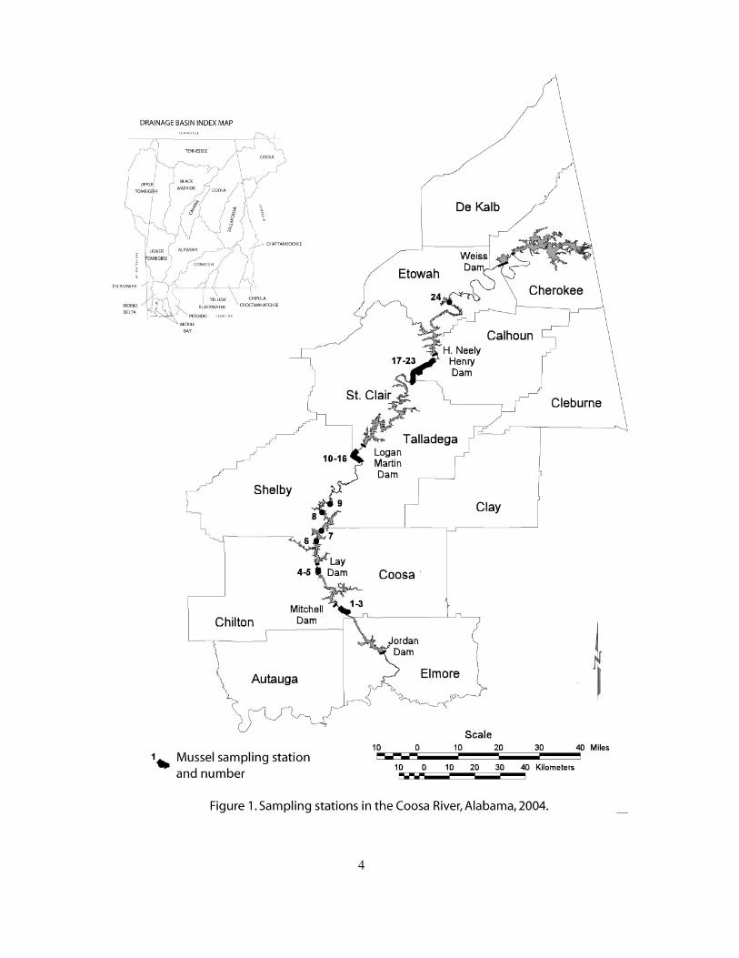
STUDY AREA The Coosa River drains an area of about 26,589 km2 (10,226 mi2) in Alabama,
Georgia, and Tennessee (Mettee and others, 1996). Sampling stations were concentrated in riverine reaches of Coosa River downstream of H. Neely Henry, Lay, Logan Martin, and Mitchell Dams and in Lay and H. Neely Henry Reservoirs (fig. 1).
The Cahaba River is the longest relatively free-flowing river in Alabama and stretches 305 kilometers (190 miles) from its source in St. Clair County to its confluence with the Alabama River in Dallas County (fig. 2). It is a major tributary of the Alabama River, draining approximately 4,725 km2 (1,825 mi2). The main channel flows through St. Clair, Jefferson, Shelby, Bibb, Perry, and Dallas Counties and also drains portions of Tuscaloosa and Chilton Counties.
METHODS Mussels were collected by hand with the aid of a boat-mounted surface air source
in large-river habitat and with the aid of mask and snorkel and hand picking in shallow areas and along shorelines. Sampling stations were selected based on the presumed presence of habitat suitable for listed mussel species. Sampling duration at each station was dictated by the fauna and sampling conditions encountered. Sampling was on a time-limited basis opposed to an area-limited basis, as suggested for the most effective collection of rare species present at a site by Vaughn and others (1997) and Metcalfe-Smith and others (2000). An average sample effort of approximately one person-hour per station, ranging from 0.08 hour (5 minutes) to 3 hours was logged while diving. A similar procedure was followed for stations sampled with mask and snorkel, with effort ranging from 1.6 hours to 7 hours. All mussels encountered were collected, identified to species and condition (live, fresh dead, weathered dead, or relic), and the number of each recorded. Most live material was identified in the field and returned to the substrate. Only live and fresh dead material was used for species totals and abundance calculations.
3
4

5
Weathered dead and relic material were excluded from those calculations, since it is impossible to determine how long those animals have been dead and whether they persist. Voucher material is housed in the ADCNR or North Carolina Museum of Natural Science collections. Habitat data for each station were also recorded. Sampling stations were referenced to nearby landmarks, and position was determined with a hand-held Global Positioning System (GPS) unit or with the aid of the on-line internet topographic mapping program TopoZone. Nomenclature generally follows Turgeon and others (1998).
RESULTS Coosa River
Qualitative sampling for freshwater mussels was conducted at 24 stations in tailwaters of dams and in reservoirs on the Coosa River (fig. 1, table 1). About 21 hours of bottom time was shared among these stations, yielding a cumulative total of 23 species, 19 of which were represented by live animals or fresh dead shells and four by weathered dead or relic shells only (table 2). Cumulative species lists and totals are presented by reach in table 2. A total of 1,110 live or fresh dead animals was collected with a catch per unit effort (CPUE) of 52.8 per hour. Sampling was concentrated in areas of appropriate habitat for target species with reasonable effort expended based on best professional judgment to maximize the likelihood of encountering those species. The most productive areas sampled were the tailwaters of Logan Martin Dam (19 species, 15 live or fresh dead) and H. Neely Henry Dam (16 species, 10 live or fresh dead). Low abundance and diversity were found in Lay Reservoir (three species live or fresh dead), Lay Dam tailwaters (four species live or fresh dead) and H. Neely Henry Reservoir (five species live or fresh dead). The Southern Mapleleaf, Quadrula apiculata, was collected in all reaches sampled except H. Neely Henry Reservoir and represented 55.7 percent of the total collected. The Three-horn Wartyback, Obliquaria reflexa, was collected in all reaches sampled and represented 17.4 percent of the total. Fourteen species each represented less than 1 percent of the total. Each reach sampled will be discussed separately below.
The tailwaters of Logan Martin Dam yielded the most species of any area sampled. The fauna was comprised of 19 species, 15 of which were collected live or fresh dead. A total of 525 individuals were collected in 10.0 hours of bottom time, yielding a CPUE of 52.5 mussels per hour (table 2). Effort was shared among eight stations in this reach (fig. 1, table 1, stations 10-16). Effort was concentrated from near the mouth of Kelly Creek downstream past Elliott Island, the first island downstream of Kelly Creek, to the vicinity of Buzzard Island, the second island downstream of that point. The most productive areas were around Elliott and Buzzard Islands (stations 10, 11, 14, 15), where the habitat was generally mixed boulders, cobble, gravel, sand, and large woody debris, with some areas of level sand and gravel. Among the species collected live was the federally endangered Southern Clubshell, Pleurobema decisum (two live individuals and seven relic shells). Other species of note include the Alabama Spike, Elliptio arca (four live, one fresh dead, and three relics), the Black Sandshell, Ligumia recta (three relics), and the Fawnsfoot, Truncilla donaciformis (one live, two weathered dead).
The tailwaters of H. Neely Henry Dam yielded a similar fauna to that in the tailwaters of Logan Martin Dam, comprised of 16 species (9 live or fresh dead and 7 weathered dead or relic) collected in about 3.8 hours of bottom time yielding a CPUE of
6
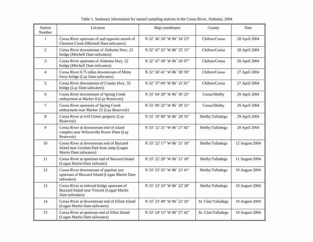
Table 1. Summary information for mussel sampling stations in the Coosa River, Alabama, 2004
Station Number
Location Map coordinates County Date
1 Coosa River upstream of and opposite mouth of Chestnut Creek (Mitchell Dam tailwaters)
N 32˚ 46' 34" W 86˚ 24' 23" Chilton/Coosa 28 April 2004
2 Coosa River downstream of Alabama Hwy. 22 bridge (Mitchell Dam tailwaters)
N 32˚ 47' 32" W 86˚ 25' 15" Chilton/Coosa 28 April 2004
3 Coosa River upstream of Alabama Hwy. 22 bridge (Mitchell Dam tailwaters)
N 32˚ 47' 58" W 86˚ 26' 07" Chilton/Coosa 28 April 2004
4 Coosa River 0.75 miles downstream of Mims Ferry bridge (Lay Dam tailwaters)
N 32˚ 56' 41" W 86˚ 30' 59" Chilton/Coosa 27 April 2004
5 Coosa River downstream of County Hwy. 55 bridge (Lay Dam tailwaters)
N 32˚ 57' 04" W 86˚ 31' 01" Chilton/Coosa 27 April 2004
6 Coosa River downstream of Spring Creek embayment at Marker 8 (Lay Reservoir)
N 33˚ 04' 28" W 86˚ 30' 23" Coosa/Shelby 29 April 2004
7 Coosa River upstream of Spring Creek embayment near Marker 22 (Lay Reservoir)
N 33˚ 06' 32" W 86˚ 29' 15" Coosa/Shelby 29 April 2004
8 Coosa River at 4-H Center property (Lay Reservoir)
N 33˚ 10' 09" W 86˚ 29' 35" Shelby/Talladega 29 April 2004
9 Coosa River at downstream end of island complex near Wilsonville Power Plant (Lay Reservoir)
N 33˚ 12' 21" W 86˚ 27' 42" Shelby/Talladega 29 April 2004
10 Coosa River at downstream end of Buzzard Island near Gorman Park boat ramp (Logan Martin Dam tailwaters)
N 33˚ 22' 17" W 86˚ 21' 18" Shelby/Talladega 12 August 2004
11 Coosa River at upstream end of Buzzard Island (Logan Martin Dam tailwater)
N 33˚ 22' 28" W 86˚ 21' 18" Shelby/Talladega 11 August 2004
12 Coosa River downstream of pipeline just upstream of Buzzard Island (Logan Martin Dam tailwaters)
N 33˚ 23' 35" W 86˚ 22' 41" Shelby/Talladega 10 August 2004
13 Coosa River at railroad bridge upstream of Buzzard Island near Vincent (Logan Martin Dam tailwaters)
N 33˚ 23' 10" W 86˚ 22' 38" Shelby/Talladega 10 August 2004
14 Coosa River at downstream end of Elliott Island (Logan Martin Dam tailwaters)
N 33˚ 23' 49" W 86˚ 22' 26" St. Clair/Talladega 10 August 2004
15 Coosa River at upstream end of Elliot Island (Logan Martin Dam tailwaters)
N 33˚ 24' 15" W 86˚ 57' 42" St. Clair/Talladega 10 August 2004
Table 1. Summary information for mussel sampling stations in the Coosa River, Alabama, 2004--continued 16 Coosa River downstream of Kelly Creek mouth
(Logan Martin Dam tailwaters) N 33˚ 24' 27" W 86˚ 21' 51" St. Clair/Talladega 10 August 2004
17 Coosa River in Woods Bend near Ragland (H. Neely Henry Dam tailwaters)
N 33˚ 40' 20" W 86˚ 09' 31" St. Clair/Talladega 29 July 2004
18 Coosa River just downstream of Trout Creek mouth in Kirksey’s Bend (H. Neely Henry Dam tailwaters)
N 33˚ 42' 31" W 86˚ 08' 41" Calhoun/St. Clair 29 July 2004
19 Coosa River downstream of Aker Creek mouth (H. Neely Henry Dam tailwaters)
N 33˚ 42' 46" W 86˚ 07' 43" Calhoun/St. Clair 28 July 2004
20 Coosa River just upstream of Aker Creek (H. Neely Henry Dam tailwaters)
N 33˚ 43' 27" W 86˚ 07' 04" Calhoun/St. Clair 28 July 2004
21 Coosa River upstream of Cane Creek mouth (H. Neely Henry Dam tailwaters)
N 33˚ 44' 18" W 86˚ 05' 53" Calhoun/St. Clair 28 July 2004
22 Coosa River upstream of Lick Branch mouth near old gravel quarry (H. Neely Henry Dam tailwatrs)
N 33˚ 45' 11" W 86˚ 04' 25" Calhoun/St. Clair 28 July 2004
23 Coosa River upstream of Lick Branch (H. Neely Henry Dam tailwaters)
N 33˚ 45' 32" W 86˚ 04' 00" Calhoun/St. Clair 27 July 2004
24 Coosa River at U.S. Hwy. 278/431 bridge in Gadsden (H. Neely Henry Reservoir)
N 34˚ 00' 43" W 85˚ 59' 49" Etowah 27 July 2004
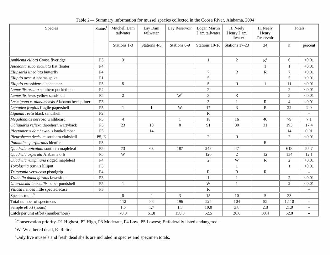
Table 2— Summary information for mussel species collected in the Coosa River, Alabama, 2004
Mitchell Dam tailwater
Lay Dam tailwater
Lay Reservoir Logan Martin Dam tailwater
H. Neely Henry Dam
tailwater
H. Neely Henry
Reservoir
Totals Species Status1
Stations 1-3 Stations 4-5 Stations 6-9 Stations 10-16 Stations 17-23 24 n percent
Amblema elliotti Coosa fiveridge P3 3 1 2 R1 6 <0.01Anodonta suborbiculata flat floater P4 1 1 <0.01Ellipsaria lineolata butterfly P4 7 R R 7 <0.01 Elliptio arca Alabama spike P1 5 5 <0.01Elliptio crassidens elephantear P5 5 5 R 1 11 <0.01Lampsilis ornata southern pocketbook P4 2 2 <0.01Lampsilis teres yellow sandshell P5 2 W2 3 R 5 <0.01Lasmigona c. alabamensis Alabama heelsplitter P3 3 1 R 4 <0.01 Leptodea fragilis fragile papershell P5 1 1 W 17 3 R 22 2.0 Ligumia recta black sandshell P2 R -- Megalonaias nervosa washboard P5 4 1 18 16 40 79 7.1 Obliquaria reflexa threehorn wartyback P5 23 10 8 91 30 31 193 17.4Plectomerus dombeyanus bankclimber P5 14 14 0.01Pleurobema decisum southern clubshell P5, E 2 R 2 <0.01 Potamilus purpuratus bleufer P5 R --Quadrula apiculata southern mapleleaf P5 73 63 187 248 47 618 55.7Quadrula asperata Alabama orb P5 W 120 2 12 134 12.1 Quadrula rumphiana ridged mapleleaf P4 2 W R 2 <0.01 Toxolasma parvus lilliput P3 1 1 <0.01Tritogonia verrucosa pistolgrip P4 R R R --Truncilla donaciformis fawnsfoot P3 1 1 2 <0.01Utterbackia imbecillis paper pondshell P5 1 W 1 2 <0.01Villosa lienosa little spectaclecase P5 R -- Species totals3 8 4 3 15 10 5 23 --Total number of specimens 112 88 196 525 104 85 1,110 -- Sample effort (hours) 1.6 1.7 1.3 10.0 3.8 2.8 21.0 -- Catch per unit effort (number/hour) 70.0 51.8 150.8 52.5 26.8 30.4 52.8 --
1Conservation priority–P1 Highest, P2 High, P3 Moderate, P4 Low, P5 Lowest; E=federally listed endangered. 2W–Weathered dead, R–Relic. 3Only live mussels and fresh dead shells are included in species and specimen totals.
26.8 mussels per hour (table 2). Effort was shared among seven stations in this reach (fig. 1, table 1, stations 17-23). Only two old relics of the Southern Clubshell were collected. Other species of note included the Fawnsfoot (one live individual) and what appeared to be a fresh dead Lilliput, Toxolasma parvus. The systematic status of the genus Toxolasma is problematic and probably represents a more diverse genus than is currently recognized. The individual found here expressed female shell characteristics and had white nacre, suggesting it is T. parvus or would fall into the group currently assigned to that species, pending further study. The substrate in this reach was comprised of bedrock, boulders, cobble, gravel, and sand; silt accumulations ranging from 1 to 4 mm deep were common during periods of no flow.
The next most productive reach sampled was in the H. Neely Henry Reservoir near Gadsden (fig. 1, table 1, station 24). Here 12 species (5 live or fresh dead, 7 weathered dead or relic) were collected in about 2.8 hours of bottom time yielding a CPUE of 30.4 mussels per hour (table 2). No federally listed species were collected. The diverse fauna found there with minimal sampling effort offers hope that more species, including federally listed species, could be found with additional effort. Some areas of stable sand were found among cobble, gravel, and considerable garbage accumulated over many years from the nearby highway.
The tailwaters of Mitchell Dam yielded nine species (eight live or fresh dead, one weathered dead) in about 1.6 hours of bottom time with a CPUE of 70.0 mussels per hour (table 2). Effort was spread among three stations in this reach (fig. 1, table 1, stations 1-3). Extensive areas of bedrock and boulders with limited areas of coarse sand and a heavy layer of silt reduced the likelihood of finding mussels, and it is unlikely that there is a significant chance of finding federally listed species in this reach.
Sampling in the tailwaters of Lay Dam yielded four species commonly found in reservoirs (all represented by live animals) in about 1.7 hours of bottom time with a CPUE of 51.8 mussels per hour (table 2). Two stations were sampled in this reach (fig. 1, table 1, stations 4, 5). Habitat varied from generally poor gravel/cobble with interstitial sand at one station to jumbled, flat boulders with moderate to heavy silt at the other station, and it is unlikely there is a significant chance of finding federally listed species in this reach.
Sampling in Lay Reservoir yielded 5 species, including 196 specimens of 3 species live or fresh dead and 2 species represented by weathered dead or relic shells, all typical of reservoir habitat. About 1.3 hours of bottom time yielded a CPUE of 150.8 mussels per hour (table 2). The relatively high CPUE is misleading when only three species were collected live or fresh dead and one species represented 95 percent of the total collected. Habitat at each station sampled was composed of firm mud and silt with large woody debris. It is unlikely that there is a significant chance of finding federally listed species in this environment.
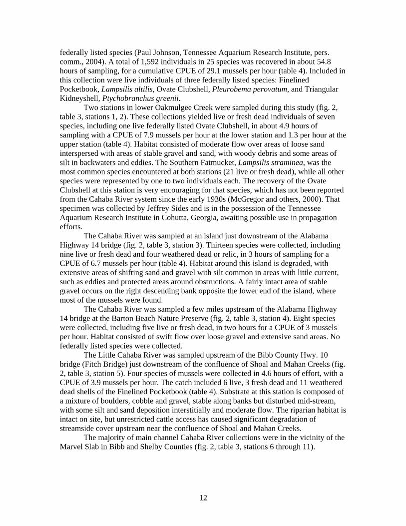
Cahaba River Qualitative mussel sampling was performed at 12 stations in the Cahaba River
proper and at 3 stations in two tributaries, Oakmulgee Creek and Little Cahaba River (fig. 2, table 3). Sampling stations were determined based on prior knowledge of recent records of federally listed species (McGregor and others, 2000) and recent collections of
10
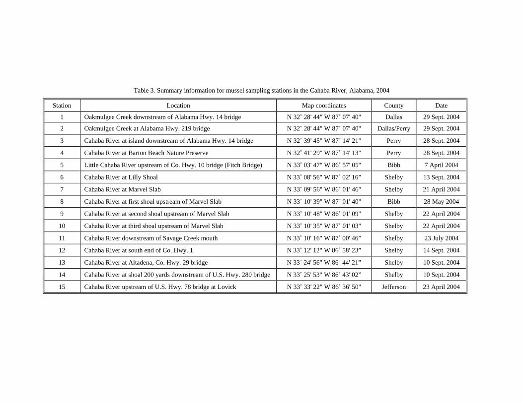
Table 3. Summary information for mussel sampling stations in the Cahaba River, Alabama, 2004
Station Location Map coordinates County Date
1 Oakmulgee Creek downstream of Alabama Hwy. 14 bridge N 32˚ 28' 44" W 87˚ 07' 40" Dallas 29 Sept. 2004
2 Oakmulgee Creek at Alabama Hwy. 219 bridge N 32˚ 28' 44" W 87˚ 07' 40" Dallas/Perry 29 Sept. 2004
3 Cahaba River at island downstream of Alabama Hwy. 14 bridge N 32˚ 39' 45" W 87˚ 14' 21" Perry 28 Sept. 2004
4 Cahaba River at Barton Beach Nature Preserve N 32˚ 41' 29" W 87˚ 14' 13" Perry 28 Sept. 2004
5 Little Cahaba River upstream of Co. Hwy. 10 bridge (Fitch Bridge) N 33˚ 03' 47" W 86˚ 57' 05" Bibb 7 April 2004
6 Cahaba River at Lilly Shoal N 33˚ 08' 56" W 87˚ 02' 16” Shelby 13 Sept. 2004
7 Cahaba River at Marvel Slab N 33˚ 09' 56" W 86˚ 01' 46" Shelby 21 April 2004
8 Cahaba River at first shoal upstream of Marvel Slab N 33˚ 10' 39" W 87˚ 01' 40" Bibb 28 May 2004
9 Cahaba River at second shoal upstream of Marvel Slab N 33˚ 10' 48" W 86˚ 01' 09" Shelby 22 April 2004
10 Cahaba River at third shoal upstream of Marvel Slab N 33˚ 10' 35" W 87˚ 01' 03" Shelby 22 April 2004
11 Cahaba River downstream of Savage Creek mouth N 33˚ 10' 16" W 87˚ 00' 46” Shelby 23 July 2004
12 Cahaba River at south end of Co. Hwy. 1 N 33˚ 12' 12" W 86˚ 58' 23” Shelby 14 Sept. 2004
13 Cahaba River at Altadena, Co. Hwy. 29 bridge N 33˚ 24' 56" W 86˚ 44' 21” Shelby 10 Sept. 2004
14 Cahaba River at shoal 200 yards downstream of U.S. Hwy. 280 bridge N 33˚ 25' 53" W 86˚ 43' 02” Shelby 10 Sept. 2004
15 Cahaba River upstream of U.S. Hwy. 78 bridge at Lovick N 33˚ 33' 22" W 86˚ 36' 50" Jefferson 23 April 2004
federally listed species (Paul Johnson, Tennessee Aquarium Research Institute, pers. comm., 2004). A total of 1,592 individuals in 25 species was recovered in about 54.8 hours of sampling, for a cumulative CPUE of 29.1 mussels per hour (table 4). Included in this collection were live individuals of three federally listed species: Finelined Pocketbook, Lampsilis altilis, Ovate Clubshell, Pleurobema perovatum, and Triangular Kidneyshell, Ptychobranchus greenii.
Two stations in lower Oakmulgee Creek were sampled during this study (fig. 2, table 3, stations 1, 2). These collections yielded live or fresh dead individuals of seven species, including one live federally listed Ovate Clubshell, in about 4.9 hours of sampling with a CPUE of 7.9 mussels per hour at the lower station and 1.3 per hour at the upper station (table 4). Habitat consisted of moderate flow over areas of loose sand interspersed with areas of stable gravel and sand, with woody debris and some areas of silt in backwaters and eddies. The Southern Fatmucket, Lampsilis straminea, was the most common species encountered at both stations (21 live or fresh dead), while all other species were represented by one to two individuals each. The recovery of the Ovate Clubshell at this station is very encouraging for that species, which has not been reported from the Cahaba River system since the early 1930s (McGregor and others, 2000). That specimen was collected by Jeffrey Sides and is in the possession of the Tennessee Aquarium Research Institute in Cohutta, Georgia, awaiting possible use in propagation efforts.
The Cahaba River was sampled at an island just downstream of the Alabama Highway 14 bridge (fig. 2, table 3, station 3). Thirteen species were collected, including nine live or fresh dead and four weathered dead or relic, in 3 hours of sampling for a CPUE of 6.7 mussels per hour (table 4). Habitat around this island is degraded, with extensive areas of shifting sand and gravel with silt common in areas with little current, such as eddies and protected areas around obstructions. A fairly intact area of stable gravel occurs on the right descending bank opposite the lower end of the island, where most of the mussels were found.
The Cahaba River was sampled a few miles upstream of the Alabama Highway 14 bridge at the Barton Beach Nature Preserve (fig. 2, table 3, station 4). Eight species were collected, including five live or fresh dead, in two hours for a CPUE of 3 mussels per hour. Habitat consisted of swift flow over loose gravel and extensive sand areas. No federally listed species were collected.
The Little Cahaba River was sampled upstream of the Bibb County Hwy. 10 bridge (Fitch Bridge) just downstream of the confluence of Shoal and Mahan Creeks (fig. 2, table 3, station 5). Four species of mussels were collected in 4.6 hours of effort, with a CPUE of 3.9 mussels per hour. The catch included 6 live, 3 fresh dead and 11 weathered dead shells of the Finelined Pocketbook (table 4). Substrate at this station is composed of a mixture of boulders, cobble and gravel, stable along banks but disturbed mid-stream, with some silt and sand deposition interstitially and moderate flow. The riparian habitat is intact on site, but unrestricted cattle access has caused significant degradation of streamside cover upstream near the confluence of Shoal and Mahan Creeks.
The majority of main channel Cahaba River collections were in the vicinity of the Marvel Slab in Bibb and Shelby Counties (fig. 2, table 3, stations 6 through 11).
12
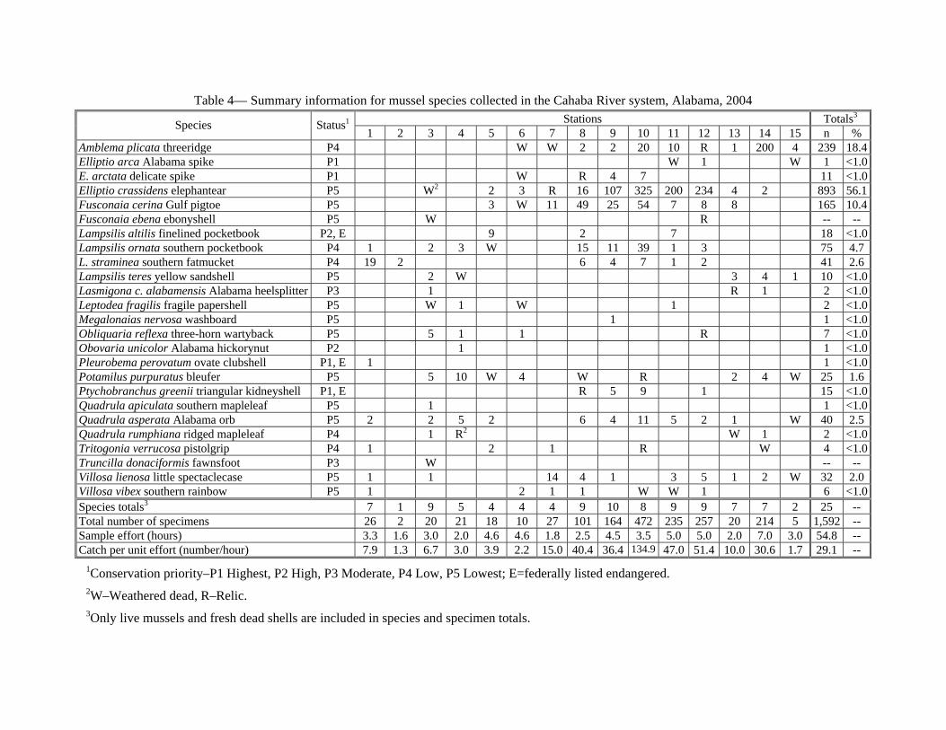
Table 4— Summary information for mussel species collected in the Cahaba River system, Alabama, 2004 Stations Totals3
Species
Status1
1 2 3 4 5 6 7 8 9 10 11 12 13 14 15 n %Amblema plicata threeridge P4 W W 2 2 20 10 R 1 200 4 239 18.4Elliptio arca Alabama spike P1 W 1 W 1 <1.0E. arctata delicate spike P1 W R 4 7 11 <1.0Elliptio crassidens elephantear P5 W2 2 3 R 16 107 325 200 234 4 2 893 56.1Fusconaia cerina Gulf pigtoe P5 3 W 11 49 25 54 7 8 8 165 10.4Fusconaia ebena ebonyshell P5 W R -- --Lampsilis altilis finelined pocketbook P2, E 9 2 7 18 <1.0Lampsilis ornata southern pocketbook P4 1 2 3 W 15 11 39 1 3 75 4.7L. straminea southern fatmucket P4 19 2 6 4 7 1 2 41 2.6Lampsilis teres yellow sandshell P5 2 W 3 4 1 10 <1.0Lasmigona c. alabamensis Alabama heelsplitter P3 1 R 1 2 <1.0Leptodea fragilis fragile papershell P5 W 1 W 1 2 <1.0Megalonaias nervosa washboard P5 1 1 .0 <1Obliquaria reflexa three-horn wartyback P5 5 1 1 R 7 <1.0Obovaria unicolor Alabama hickorynut P2 1 1 <1.0Pleurobema perovatum ovate clubshell P1, E 1 1 <1.0Potamilus purpuratus bleufer P5 5 10 W 4 W R 2 4 W 25 1.6Ptychobranchus greenii triangular kidneyshell P1, E R 5 9 1 15 <1.0Quadrula apiculata southern mapleleaf P5 1 1 .0 <1Quadrula asperata Alabama orb P5 2 2 5 2 6 4 11 5 2 1 W 40 2.5Quadrula rumphiana ridged mapleleaf P4 1 R2 W 1 2 <1.0Tritogonia verrucosa pistolgrip P4 1 2 1 R W 4 <1.0Truncilla donaciformis fawnsfoot P3 W -- --Villosa lienosa little spectaclecase P5 1 1 14 4 1 3 5 1 2 W 32 2.0Villosa vibex southern rainbow P5 1 2 1 1 W W 1 6 <1.0Species totals3 7 1 9 5 4 4 4 9 10 8 9 9 7 7 2 25 --Total number of specimens 26 2 20 21 18 10 27 101 164 472 235 257 20 214 5 1,592 -- Sample effort (hours) 3.3 1.6 3.0 2.0 4.6 4.6 1.8 2.5 4.5 3.5 5.0 5.0 2.0 7.0 3.0 54.8 --Catch per unit effort (number/hour) 7.9 1.3 6.7 3.0 3.9 2.2 15.0 40.4 36.4 134.9 47.0 51.4 10.0 30.6 1.7 29.1 --
1Conservation priority–P1 Highest, P2 High, P3 Moderate, P4 Low, P5 Lowest; E=federally listed endangered. 2W–Weathered dead, R–Relic. 3Only live mussels and fresh dead shells are included in species and specimen totals.
Emphasis was placed on this reach of river for two reasons. First, the Triangular Kidneyshell was recently (spring, 2004) collected at several stations nearby. That species had not been reported from the Cahaba River since a fresh dead shell was found upstream at Altadena in Shelby County and reported in Shepard and others (1994). McGregor and others (2000) did not report additional records of that species, and it is likely this new population was overlooked because of the remote setting of the river in this area. Second, the Marvel Slab is slated to be removed in fall, 2004, and collections pre- and post-removal were desired to document the effects of removal.
Collections were made at Lilly Shoals, just downstream of Marvel Slab and at the slab itself, in addition to a series of shoals upstream for several miles to the vicinity of the mouth of Savage Creek (fig. 2, table 3, stations 6-11). Relatively few species and few individuals were collected at Lilly Shoals (four species live or fresh dead and four weathered dead, CPUE 2.2 mussels per hour) and Marvel Slab (four species live and two weathered dead, CPUE 15.0 mussels per hour) (table 4). Neither of these stations yielded federally protected species. However, a live Finelined Pocketbook was recovered using SCUBA from the vicinity of Marvel Slab related to the removal of Marvel Slab (Paul Freeman, The Nature Conservancy, pers. comm., 2004). Stations upstream of Marvel Slab to the mouth of Savage Creek consistently yielded much higher diversity and abundance values, with CPUEs ranging from 36.4 to 134.9 mussels per hour. As many as 11 species were collected, often with several hundred individuals of a single species found. These stations were similar in character, with moderate to swift flow and varying combinations of bedrock, boulders, cobble, gravel, and sand with Justicia sp. scattered throughout, and with areas of silt and woody debris in backwaters and eddies. Species collected in this reach were the Finelined Pocketbook (9 live, with some gravid females observed in April) and the Triangular Kidneyshell (14 live). It is interesting to note that all Triangular Kidneyshells and all but two Finelined Pocketbooks were found upstream of the mouth of Shades Creek (stations 9-11), which enters the Cahaba River about one mile upstream of Marvel Slab. Shepard and others (1994) reported that Shades Creek, which drains agricultural and urban areas, was one of the most polluted streams in the upper Cahaba River watershed. That result was based on comparison of water quality, habitat, and Index of Biotic Integrity (IBI) parameters collected from three stations in Shades Creek compared to other tributary and main stem stations. The IBI scores for two stations in Shades Creek sampled during that study were poor and fair, and habitat scores for all three stations generally showed the effects of erosion problems from agricultural practices and urban runoff. In addition, detectable levels of such contaminants as lead, atrazine, and PCP were found at some stations.
A series of boulder “riffles” and a gravel point bar a short distance downstream were sampled near the terminus of Shelby County Highway 1 (fig. 2, table 3, station 12). Nine species were collected live or fresh dead and another three as relics at this location. Included was one fresh dead shell of the Triangular Kidneyshell. Another interesting record was the Alabama Spike, Elliptio arca (table 4) which was collected live. A CPUE of 51.4 mussels per hour was recorded at this station, but it should be pointed out that one species, Elliptio crassidens, represented 91 percent of that total. It also represented 56.1 percent of the total collected throughout the Cahaba River system.
At the Shelby County Highway 29 bridge, near Altadena, about two hours were spent sampling upstream of the bridge (fig. 2, table 3, station 13). This is the station where
14
the Triangular Kidneyshell was found fresh dead about 10 years previously. A total of nine species was collected, including seven collected live or fresh dead, with a CPUE of 10.0 mussels per hour (table 4), but no specimens of the Triangular Kidneyshell or any other protected species were found. There is a wastewater effluent pipe at this location, and the air had a mild odor of sewage. The habitat available at this station had changed somewhat during the past decade. During sampling in 1992, extensive areas of Justicia sp. were found from bank to bank for a long distance downstream of a mill dam located upstream in a stable gravel environment. That Justicia stand is now significantly reduced, though the gravel substrate appears to remain relatively intact.
About seven hours was spent sampling a short distance downstream of the U.S. Highway 280 bridge in Shelby County (fig. 2, table 3, station 14). A water level structure at the bridge designed to control the flow of water for water supply was located near the bridge. Eight species were collected, with seven represented by live animals, with a CPUE of about 30.6 mussels per hour (table 4). However, 200 of the 214 collected were individuals of one species; the remaining 14 individuals were shared among 6 other species. The station was characterized by areas of loose sand, gravel, and cobble with silt in slackwater areas, a large amount of woody debris, and areas of loose sand as much as 3 feet in depth.
A series of four riffle/run complexes were sampled for a total of about three hours upstream of U.S. Highway 78 at Lovick (fig. 3, table 3, station 15). Six species were collected, with only one represented by live animals, one in each shoal, and one by a fresh dead shell, with a CPUE of 1.7 mussels per hour. These areas were composed of extensive bedrock with runs of cobble, gravel, and sand. The water was clear and flow swift, but the substrate was very loose.
DISCUSSION AND RECOMMENDATIONS The collections of Pleurobema decisum in the tailwaters of Logan Martin Dam,
Ptychobranchus greenii and Lampsilis altilis from several stations in the upper Cahaba and Little Cahaba Rivers, and Pleurobema perovatum from Oakmulgee Creek offer hope that those species may also persist at other stations within those systems. However, intensive survey efforts turned up relatively few specimens of each during this study.
The diverse mussel fauna found in the tailwaters of Logan Martin and H. Neely Henry Dams on the Coosa River suggest they may be valuable as locations for reintroduction efforts or possibly as sources of broodstock for reintroduction efforts. However, it should be cautioned that this conclusion is preliminary and is based upon limited sampling effort. Further evaluation of the factors influencing the distribution of mussels in these tailwaters is necessary before the fauna can be expected to recover. Such factors as minimum flow releases, less intensive peak discharges, and other factors affecting substrate quality should be explored and addressed. Of primary importance are the H. Neely Henry and Logan Martin Dam tailwaters, where sensitive mussel species populations remain extant.
The diversity of mussels in the Cahaba River upstream of the mouth of Shades Creek, in the Little Cahaba River, and in lower Oakmulgee Creek, suggests those reaches contain habitat and ambient water quality sufficient to support diverse and abundant faunas and should be considered for reintroduction or augmentation efforts. However, the Cahaba River stations immediately downstream of the mouth of Shades Creek showed a marked decline in abundance and diversity values from stations immediately upstream of
15
that point, presumably caused by poor water quality and/or sediment introduced from Shades Creek. The extent of that presumed effect downstream is currently unknown. The impacts of urban and agricultural runoff in the Shades Creek system were reported in O’Neil (1984) and Shepard and others (1994) and included poor to fair IBI scores and low habitat scores, reflecting the effects of erosion problems from agricultural practices and urban runoff. There were also detectable levels of such contaminants as lead, atrazine, and PCP found at some stations and low dissolved oxygen events. One promising development in the possible recovery of mussels in the Cahaba River downstream of Shades Creek is the planned removal of the Marvel Slab. What was once likely an extensive shoal area was inundated by the construction of the slab several decades ago and it essentially became a small run-of-the-river impoundment. With removal of the slab it could be restored to its former condition and hopefully native mussels typical of shoals in the Cahaba River will recolonize the area.
Upstream stations in the Cahaba River, including Shelby County Highway 1, Altadena, and U.S. Highway 280, yielded relatively diverse and abundant faunas, though abundance was heavily weighted to one or a few species at each station. Habitat available at each station was substandard, but with evaluation and mitigation of the limiting factors in those reaches, we feel that mussels, including federally listed species and species of high conservation priority, could recolonize those areas. As noted before, the Triangular Kidneyshell was found fresh dead at Altadena approximately 10 years previously, but in those intervening years the extensive Justicia beds once found there have been reduced to a few small stands.
Based on the results of this study, we offer the following recommendations.
• More intensive sampling should be conducted to further evaluate the actual extent and viability of target populations before removal of broodstock is considered from any location.
• Other tailwaters reaches of the Coosa River should be further evaluated before a decision is made on source or sources of broodstock in that river. Suggested procedures for effectively sampling mussel populations can be found in Vaughn and others (1997), Metcalfe-Smith and others (2000), and Strayer and Smith (2003), and their suggested protocols or modified versions of those protocols should be used to evaluate the effects of removal of live specimens on the viability of those populations.
• Consideration should also be given to determining the factors suppressing federally listed or high conservation priority species in other tailwaters reaches and addressing those factors.
• Water-quality and physical habitat problems in the Shades Creek system should be evaluated and any possible negative effects on mussel populations ameliorated; until that time it is possible that mussel populations in the Cahaba River for an unknown distance downstream of Shades Creek may continue to be suppressed. The actual extent of that suppression downstream of the mouth of Shades Creek should also be determined, if possible.
• Effort should be made to determine other factors that contribute to suppression of the mussel fauna in some areas of the Cahaba River system
16
and steps taken to correct those factors; one such area is the destruction of streamside habitat near the confluence of Shoal and Mahan Creeks in the Little Cahaba River system that threatens a population of Lampsilis altilis.
• Consideration should be given to removing other barriers to potential fish host migration in the Cahaba River. Removal of the Marvel Slab is underway and pre-removal data are available. Progress of recovery of the fauna in that area should be evaluated over time, and information gathered should be applied to other activities that would benefit the fauna throughout the watershed.
REFERENCES CITED Baldwin, C. S. 1973, Changes in the freshwater mussel fauna in the Cahaba River over
the past 40 years: Unpublished Masters Thesis, Tuskegee Institute, Alabama, 45 p.
Basch, P. F., 1959, The Coosa revisited: Abstract, American Malacological Union Annual Report for 1959, 17 p.
Bogan, A. E., 1993, Freshwater bivalve extinctions (Mollusca: Unionoida): a search for causes: American Zoologist, v. 33, p. 599-609.
Bogan, A. E., and Pierson, J. M., 1993, Survey of the aquatic gastropods of the Coosa River basin, Alabama: 1992: Open-File report to Alabama Natural Heritage Program, Montgomery, Alabama, 13 p. + 5 Appendices.
Feminella, J. W., and Gangloff, M. M., 2000, Analysis of relationships between unionid mussels and stream hydrology in tributaries of the Coosa River, Alabama: Auburn, Alabama, Auburn University, Open-File Report to Alabama Department of Conservation and Natural Resources, 27 p.
Frey, P. J., Howard, H. S., Murphy, P. J., Rashcke, R. L., Shultz, D. A., Smith, D. R., and True, Howard, 1976, Upper Cahaba River report, Environmental Impact Statement under Sect. 201, PL 92-500: Environmental Protection Agency, Athens, Georgia. 59 p.
Gangloff, M. M., and Feminella, J. W., in press, Distribution and status of freshwater mussels (Bivalvia: Unionidae) in the Upper Alabama (Coosa and Lower Tallapoosa) drainage, Alabama: Department of Biological Sciences, Auburn University, Alabama, 121 p.
Hartfield, Paul, 1994, Status review of select mussel species in the Mobile River basin: Jackson, Mississippi, U.S. Fish and Wildlife Service, 3 p.
Herod, J. J., Blalock-Herod, H. N., Ruessler, D. S., Williams, J. D., Gross, T. S., and Kernaghan, N. J., 2001, Examination of the freshwater mussel (Bivalvia: Unionidae) community, including the federally endangered southern clubshell, Pleurobema decisum, within the Old Channel of the Coosa River, between Weiss Spillway Dam and Weiss Hydropower Dam, Cherokee County, Alabama: Gainesville, Florida, U.S. Geological Survey Open-File report, 54 p.
17
Hurd, J. C., 1974, Systematics and zoogeography of the unionacean mollusks of the Coosa River drainage of Alabama, Georgia and Tennessee: Auburn University, Alabama, Ph.D. Dissertation, 240 p.
Johnson, R. I. 1967, Additions to the unionid fauna of the gulf drainages of Alabama, Georgia and Florida (Mollusca: Bivalvia): Breviora, v. 270, 21 p.
Lewis, J. 1876, Fauna of Alabama: Freshwater and land shells of Alabama: Alabama Geological Survey report of progress for 1876, p. 61-100.
McGregor, S. W., O'Neil, P. E., and Pierson, J. M., 2000, Status of the freshwater mussel (Bivalvia: Unionidae) fauna in the Cahaba River system, Alabama: Walkerana, v. 11, no. 26, p. 215-237.
Metcalfe-Smith, F. L., Di Maio, Joanne, Staton, S. K., and Mackie, G. L., 2000, Effect of sampling effort on the efficiency of the timed search method for sampling freshwater mussel communities: North American Benthological Society Journal, v. 19, no. 4, p. 725-732.
Mettee, M. F., O=Neil, P. E., and Pierson, J. M., 1996, Fishes of Alabama and the Mobile basin: Birmingham, Oxmoor House, 820 p.
O'Neil, P. E., 1984, Historical surface water-quality analysis of the Cahaba River basin north of Centreville, Alabama: Alabama Geological Survey Open-file report, 86 p.
Shepard, T. E., O'Neil, P. E., McGregor, S. W., and Harris, S. C., 1994, Water-quality and biomonitoring studies in the Upper Cahaba River drainage of Alabama: Geological Survey of Alabama Bulletin 160, 118 p.
Stansbery, D. H., 1983a, The status of Pleurobema decisum: Columbus, The Ohio State University Museum of Zoology, 10 p.
Stansbery, D. H., 1983b, The status of Pleurobema taitianum: Columbus, The Ohio State University Museum of Zoology, 10 p.
Stansbery, D. H., 1983c, The status of Epioblasma penita: Columbus, The Ohio State University Museum of Zoology, 15 p.
Strayer, D. L., and Smith, D. R., 2003, A guide to sampling freshwater mussel populations: American Fisheries Society, Monograph 8, Bethesda, Maryland, 103 p.
Turgeon, D. D., Quinn, Jr., J. F., Bogan, A. E., Coan, E. V., Hochberg, F. G., Lyons, W. G., Mikkelsen, P. M., Neves, R. J., Roper, C. F. E., Rosenberg, G., Roth, B., Scheltema, A., Thompson, F. G., Vecchione, M., and Williams, J. D., 1998, Common and scientific names of aquatic invertebrates from the United States and Canada: Mollusks, second edition: Bethesda, Maryland, American Fisheries Society, Special Publication 26, 526 p.
van der Schalie, Henry, 1938, The naiades (fresh-water mussels) of the Cahaba River in northern Alabama: Occasional Papers of the Museum of Zoology, University of Michigan, 392, 29 p.
18
van der Schalie, Henry, 1981, Perspective on North American Malacology I. Mollusks in the Alabama River drainage; past and present: Sterkiana, v. 71, p. 24-41.
Vaughn, C. C., Taylor, C. M., and Eberhard, K. J., 1997, A comparison of the effectiveness of timed searches vs. quadrat sampling in mussel surveys: Conservation and Management of Freshwater Mussels II: Initiatives for the Future, Proceedings of a symposium organized by the Upper Mississippi Conservation Committee, Cummings, K. S., Buchanan, A. C., Mayer, C. A., and Naimo, T. J., eds., October 16-18, 1995, St. Louis, Missouri, 293 p.
19
GEOLOGICAL SURVEY OF ALABAMA P.O. Box 869999
420 Hackberry Lane Tuscaloosa, Alabama 35486-6999
205/349-2852
Berry H. (Nick) Tew, Jr., State Geologist
A list of the printed publications by the Geological Survey of Alabama can be obtained from the Publications Sales Office (205/247-3636) or
through our web site at http://www.gsa.state.al.us/.
E-mail: [email protected]
As a recipient of Federal financial assistance from the U.S. Department of the Interior, the GSA prohibits discrimination on the basis of race, color, national origin, age, or disability in its programs or activities. Discrimination on the basis of sex is prohibited in federally assisted GSA education programs. If anyone believes that he or she has been discriminated against in any of the GSA’s programs or activities, including its employment practices, the individual may contact the U.S. Geological Survey, U.S. Department of the Interior, Washington, D.C. 20240.
AN EQUAL OPPORTUNITY EMPLOYER
Serving Alabama since 1848