Embed Size (px)
Citation preview

Surficial Geology of the Kingston Quadrangle Rhode IslandBy CLIFFORD A. KAYE
CONTRIBUTIONS TO GENERAL GEOLOGY
GEOLOGICAL SURVEY BULLETIN 1071-1
Prepared in cooperation with the Development Council of the State of Rhode Island
UNITED STATES GOVERNMENT PRINTING OFFICE, WASHINGTON : 1960

UNITED STATES DEPARTMENT OF THE INTERIOR
FRED A. SEATON, Secretary
GEOLOGICAL SURVEY
Thomas B. Nolan, Director
For sale by the Superintendent of Documents, U.S. Government Printing Office Washington 25, D.C.

CONTENTSPage
Abstract. _________________________________________________________ 341Introduction ______________________________________________________ 342Geographic description._--____-____.__----___._.__._-_.._._________ 342Outline of Pleistocene geology_----__------_-----__--_----_-_-_______ 345
Preglacial topography.___-_________-----__-.-__________________ 345Direction of ice movement... ___________________________________ 345Narragansett basin ice and upland ice_-----_-___-_-___-___-______ 346Deglaciation _____--_______-____-_---_-_--.___-__--___-_.___.__ 346
Pleistocene deposits._______________________________________________ 347Light till.___________.___._..___.__._._.....-....-_.._.._._... 347Dark till__...___.__._._______________ __._._.._.___.____.____ 347Washed till..___.__.__.__.._._._.__..__.._._.______._._.._.__. 348Sorted drift.__________________________________________________ 348
Description of map units___________________________________________ 350Ground-moraine deposits.______________________________________ 350Ablation-moraine deposits. -_-_-_-_---_-_-_-__--_---___-_.______ 351
Recognition of Pleistocene ablation moraines___-__._--_---_.__ 351Charlestown moraine.___.___-_-_-__--___-___--__.__________ 359
Description.______--___-_-_-_-_-_-_-___-_-___.________ 359Origin. .. ___-_-_....._...__._.....__-___....._____. 363
Ablation-moraine complex of the Narragansett basin ice..______ 368Ablation moraine, undifferentiated..-.-.-.-.-...-.-----...... 371
Ice-contact deposits.__-_._-_-___-_-_---_---___-_---___--.______ 371Kames....____._...._.__..__.______._._._._.._.___...__... 372Kame terraces__---_-_-_____-_-_____-_-__.__-_-___._.______ 373Kame plains-__-_-_-_-.____---_-_---_-_______-_____.______ 373Kame deltas. _____________________________________________ 373Ice-channel fillings.________________________________________ 373Ice-contact deposits, undifferentiated..__._.__.____.___.____.. 374
Proglacial deposits..___________________________________________ 374Deposits of glacial Lake Worden____________________________ 374Outwash plains..__________________________________________ 377
Postglacial deposits.___________________________________________ 377Swamps--_-------_--__-_-.-_---_--._-_-____----_-_-_.__-_ 377Littoral deposits__________________._________-___-_-.._.._ 378
Beaches.-_._-___-_-_._-_-.-...--.___--_-------.--_-._ 378Forcduncs.___________________________________________ 378Sand aprons______.__._______.___._._.__.__._._.______ 379
Pattern of deglaciation.__..___________._.___._____..__._____...____ 379Features of probable late glacial age_________________________________ 382
Eolian mantle.__-__--_--__________.-.-.______-_-_-_-_-_.__._._ 382Possible permafrost..__.___.._..._._______-_______-_ _________.. 383Age of the drift and possible multiple glaciation-_______-__--______ 384
Position of sea level--_-_-___-___________.___.__--_______-_-_--_____ 387Postglacial erosion.________________________________________________ 388Shoreline changes...._-_-_-___________-_____-_________-.-_-_-_..___ 388
in

IV CONTENTS
Page Engineering geology_______________________________________________ 389
Light till.____________________________________________________ 389Dark till---__--_-___-_------_____-__-___--__-_-__--_---___--- 390Sorted drift and washed till..--.__-------._-__-_-.___----------- 390Eolian mantle________________________________________ T ________ 392Swamp deposits.._____________________________________________ 392Littoral deposits___________--_________________-____----_-_--_ 392
References cited___________________________________________________ 392Index..__...______.__.____._.- .__.._____._-_._._..__-..---__._. 395
ILLUSTRATIONS[Plates in pocket]
PLATE 32. Surficial geology of the Kingston quadrangle.33. Pattern of ice wastage in five arbitrarily selected intervals,
Kingston quadrangle.34. Suggested depositional sequence of Pleistocene deposits,
Kingston quadrangle.Page
FIGURE 46. Index map of Rhode Island and adjacent areas of southern New England showing the location of the Kingston quad- rangle and extent of major glacial moraines. _____________ 344
47. Laminated sand and silt of varved aspect from ablation- moraine complex of Narragansett basin ice___________j___ 349
48. Genetic difference between ground moraine and ablationmoraine _____________________________________________ 350
49. Diagrams showing filling of an ice basin by an ablationmoraine and the ablation moraine after deglaciation_______ 353
50. Distorted bedding in interbedded sand and silt of ablation- moraine complex, Block Island___---_________----_____- 354
51. Stratified till, Block Island___...._--_.__._.__--_...--_..- 35652. Stratified till from an ablation-moraine complex at Block
Island..____--_------__---________________-__--___-__ 35753. A 17th-century map showing the Charlestown moraine. _____ 35954. Stereopair of aerial photographs of east end of Charlestown
moraine (The Hills)--_____--________________----__--_- 36155. Stereopair of aerial photographs of Charlestown moraine at
west edge of Kingston quadrangle_________-_-----_-_--_- 36256. Schematic north-south cross section showing development of
the Charlestown moraine. -_-_____-_____-____--____--__ 36757. Shore cliff north of Point Judith lighthouse after hurricane of
August 30, 1954_.______________.____...________._.___ 36958. Map of the Kingston quadrangle showing location of the ice
front during a halt of the Charlestown moraine.__________ 37059. Diagram showing some of the principal genetic and morpho-
logic differences between deposits mapped as ablation moraine and as ice-contact deposits_____________________ 372
60. Cross section showing relation between stagnant ice and driftat east edge of Narragansett basin ice during glaciation____ 381
61. Frost-riven boulder, probably indicating deep ground ice, ingravel pit north of Snug Harbor._______________________ 383
62. Shore erosion resulting from hurricane of August 30, 1954____ 390

CONTRIBUTIONS TO GENERAL GEOLOGY
SURFICIAL GEOLOGY OF THE KINGSTON QUADRANGLE,RHODE ISLAND
By CLIFFORD A. KAYE
ABSTRACT
Evidence of only' 1 Pleistocene glaciation is recognized in the Kingston quadrangle, although exposures to the south on Block Island indicate that 2, and possibly 3, glaciations took place. The glacial drift in the Kingston quad rangle is divided into (a) that deposited by ice from the New England Up land and characterized by light-colored till made up of debris from the crys talline rock of the upland, and (b) that deposited by the Narragansett basin ice and characterized by dark-colored till derived from the distinctive rocks of the Narragansett basin. Although the division between the two drifts is relatively sharp, this fact does not denote separate ice sheets but rather dif ferent sectors of the same ice sheet whose flow paths crossed different rock terra nes.
The recognition of Pleistocene ablation moraines is discussed because this type of deposit is of particular importance in the Kingston quadrangle. De posits of ablation origin may be characterized by one or more of the following features: stratified till, deposits that show all degrees of sorting, interstrati- fication of till and sorted drift, contorted bedding on a large scale, the occur rence of ice-fracture fillings, and the tendency for bedding of the more super ficial strata to parallel the hummocky surface.
The Charlestown moraine, the eastern third of which lies within the Kingston quadrangle, probably represents a marginal belt of ablation moraine that de veloped at the edge of the upland ice during a retreatal stillstand. The mo raine consists largely of ridges and mounds; these are interpreted to be ice- fracture fillings and ice-block casts, respectively. The narrow belt of the Charlestown moraine merges on the east with a broad development of ablation moraine that is lower in elevation. This moraine, which is probably contem poraneous with the Charlestown moraine, was deposited on the Narragansett basin ice. The distribution of these moraines indicates that the Narragansett basin ice formed a lobate projection well beyond the front of the upland ice, when the latter stood at the Charlestown moraine.
The ice receded from the area mostly by dowmvastage. Blocks of stagnant ice remained in the valleys after the hills were entirely exposed. Where ice was insulated by a blanket of thick moraine, its melting was retarded. Sev eral of the ablation moraines, therefore, had cores of stagnant ice that lasted long after ice to the north had melted away. Glacial melt waters transported and deposited morainic debris between and over much of the stagnant ice in low-lying places. The courses taken by melt-water drainage changed as de- glaciation progressed. Thus drainage of the area north of the Charlestown
34.1

342 CONTRIBUTIONS TO GENERAL GEOLOGY
moraine passed through the permeable ice core of the ablation moraines in its early stage. Later, with the wastage of this ice, melt water probably escaped westward through the valley of the Pawcatuck River. At that time a lake formed in the ramifying basin now partly occupied by the Great Swamp and Worclen Pond.
The age of the drift in the Kingston quadrangle is possibly late Wisconsin (Cary?). An age of 12,090+200 years was determined by radiocarbon dating of wood from the base of a kettle deposit on Block Island. The wood pre sumably represents early postglacial forest growth. Evidence in the Kingston quadrangle of deep ground ice, or permafrost, consists of ice-wedge structures, frost-riven boulders, and faint traces of thermokarst topography. This points to the existence of a boreal and perhaps periglacial climate sometime after the deposition of outwash and during, or after, the deposition of the mantle of eolian silt that blankets much of the area. No evidence of sea levels higher than the present levels was found, suggesting that (a) sea levels have never been higher, eustatically, than at present since the last glaciation of the area, or (b) if they have, subsequent crustal subsidence has effaced all evidence of this. At present, the shore in the Kingston quadrangle area is receding as a result of occasional heavy storms. Geologic evidence points to shore recession as having been the dominant process for a considerable period of time.
This report is one of the series of geological studies of the State of Rhode Island that will eventually include separate maps and re ports on bedrock and surficial geology for each lifammuie quad rangle in the State. This comprehensive program of geologic map ping is being supported jointly by the Development Council of the State of Rhode Island and the U.S. Geological Survey.
Fieldwork for this report on the surficial geology of the Kingston quadrangle was done in the summer of 1954.
Acknowledgment is made of well data kindly furnished by Wil liam H. Bierschenk, U.S. Geological Survey, and of the fruitful discussions on salient points of geology with Professor Robert L. Nichols of Tufts College and several colleagues from the Geological Survey Joseph H. Hartshorn, Walter R. Power, Jr., and John P. Schafer. The manuscript was reviewed by Louis W. Currier, Dwight R. Crandell, and Joseph H. Hartshorn.
GEOGRAPHIC DESCRIPTION
The Kingston quadrangle is in south-central Rhode Island, in Washington County, or as the district is traditionally called "South County" (fig. 46). It includes a segment of the "south shore," the popular seaside recreational area of the State.
The contiguous communities of Wakefield and Peace Dale com bined population 5,224, in the 1950 census are the largest villages in the quadrangle. Wakefield is chiefly a shopping center, and Peace Dale is a textile mill town. The small village of Kingston, which lies several miles to the north of this community, is the seat

SURFICIAL GEOLOGY OF THE KINGSTON QUADRANGLE 343
of the University of Rhode Island. The shore areas of the quad rangle, particularly Green Hill, Browning Beach, Matunuck, Jeru salem, Galilee, and the slopes above Point Judith Pond, are densely studded with summer cottages; and large summer homes are scat tered about the eastern part of the belt of hills (the Charlestown moraine) in the southern part of the quadrangle.
The quadrangle includes some of the best agricultural land in the State. The flat expanses of outwash sand and gravel are planted mostly in potatoes, which are the main crop in the area; many small orchards and vegetable gardens supply some of the local market in season. Acreage that is cleared and in production, however, is much smaller today than it was in the 18th and 19th centuries, when al most the entire upland area was farmed. Now most of the upland area is covered with second-growth forest and brush.
Commercial fishing is of some importance. Boats operating out of the small port of Galilee bring in much of the lobster, bluefish, and swordfish consumed in the State. The salt ponds, or coastal lagoons, are an important source of the sweet "native," or bay, scallop (Pecten iwadians] and the large chowder clam or quahog (Mercenaria mercenaria).
Physiographically, most of the Kingston quadrangle lies in the New England Upland, a region of glacially rounded hills and flat- floored valleys underlain by metamorphic and igneous rocks. The southeastern part of the quadrangle, however, includes the west edge of the Narragansett basin, a topographic and structural basin. Topographically it consists of the Narragansett Bay and the sur rounding lowlands (fig. 46) ; structurally it is a synclinorium un derlain by relatively soft metasedimentary rocks of Pennsylvania!! age which are intruded by several granitic bodies (Quinn, 1953; Nichols, 1956).
Except for the beaches and related shoreline features, and for organic accumulations in swamps, all the topography of the King ston quadrangle is the result of glacial erosion and deposition. Pre- glacial valleys were widened and deepened by the Pleistocene ice sheets, and hills were eroded to rounded forms. Later, the rock debris carried by the ice was deposited over the bedrock surface. These morainic deposits now blanket almost all the bedrock of the Kingston quadrangle. The valleys were filled by glacial debris to considerable depth and are now broad and flat floored. The largest of these partly filled depressions is the broad area in the central part of the quadrangle that is occupied by Worden Pond and the surrounding Great Swamp. Bounding this basin on the south is a westward-trending belt of low hills and sharp-crested sinuous ridges the Charlestown moraine, one of the best-formed end moraines in New England.

344 CONTRIBUTIONS TO GENERAL GEOLOGY
!l
SURFICIAL GEOLOGY OF THE KINGSTON QUADRANGLE 345
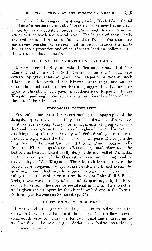
The shore of the Kingston quadrangle facing Block Island Sound consists of a continuous stretch of beach that is breached at only two places by narrow outlets of several shallow brackish-water bays and estuaries that mark the coastal area. The largest of these nearly enclosed bodies of water is Point Judith Pond. The shore has undergone considerable erosion, and in recent decades the prob lem of shore protection and of an adequate land-use policy for the shore area has become acute.
OUTLINE OF PLEISTOCENE GEOLOGY
During several lengthy intervals of Pleistocene time, all of New England and most of the North Central States and Canada were covered by great sheets of glacial ice. Deposits on nearby Block Island, 10 miles south of the Kingston quadrangle, and on the other islands off southern New England, suggest that two or more separate glaciations took place in southern New England. In the Kingston quadrangle, however, there is unequivocal evidence of only the last of these ice sheets.
PREGLACIAL TOPOGRAPHY
Few guide lines exist for reconstructing the topography of the Kingston quadrangle prior to glacial modification. Presumably most valleys existing today are enlargements of preglacial val leys and, as such, show the courses of preglacial rivers. However, in the Kingston quadrangle, the only well-defined valleys are those at the north edge, where the Usquepaug and Chipuxet Rivers join the large basin of the Great Swamp and Worclen Pond. Logs of wells from the Kingston quadrangle (Bierschenk, 1956) show that the bedrock surface lies exceptionally deep in the area called The Hills, in the eastern part of the Charlestown moraine (pi. 32), and in the vicinity of West Kingston. These bedrock lows may mark the course of a preglacial valley, which trended southward across the quadrangle, and which may have been a tributary to a hypothetical valley that is reflected at present by the axis of Point Judith Pond. Today's westward drainage of much of the quadrangle by the Paw- catuck River may, therefore, be postglacial in origin. This hypothe sis is given some support by the altitude of bedrock in the Pawca- tuck valley at Kenyon and Shannock (p. 375).
DIRECTION OF ICE MOVEMENT
Grooves and striae gouged by the glacier in its bedrock floor in dicate that the ice at least in its last stage of active flow moved south-southwestward across the Kingston quadrangle, changing to southward near the west margin. Striations on bedrock were found,

346 CONTRIBUTIONS TO GENERAL GEOLOGY
however, at only one place in the area about 700 yards east of Kenyon, where the bearing of the striae is S. 3° W. Woodworth and Wiggles worth (1934) found striae bearing S. 21° W. just east of the Kingston quadrangle, on Rose Hill (Narragansett Pier quad rangle) . Several excellent exposures of striated bedrock occur along the west shore of Narragansett Bay, 1-2 miles east of the King ston quadrangle. About l 1/^ miles south of Narragansett Pier, at the foot of Newton Avenue, glacial striae and grooves have an average bearing of S. 18° W. but vary about 5° in either direction. At Cormorant Point, northeast of Narragansett Pier, striae bear S. 25° W.
NABBAGANSETT BASIN ICE AND UPLAND ICE
Although the glacial ice that covered the Kingston quadrangle moved as an essentially continuous sheet, areal differences in mo- rainic deposits, frontal configurations, and patterns of recession (see below) justify a breakdown into two sectors: Narragansett basin ice and upland ice. The ice that moved across the southeast corner of the quadrangle had been flowing previously for many miles over the relatively soft metasedimentary rocks of the Nar ragansett basin (Quinn, 1953) and, therefore, contained distinctive morainic debris derived largely from these rocks. This ice is re ferred to as the Narragansett basin ice (fig. 58), and the till derived from it is called dark till.(p. 347). The rest of the quadrangle was covered by ice that contained the debris of the crystalline rocks of the New England Upland (Quinn, 1953). This ice is referred to as the upland ice, and till derived from it is called light till (p. 347). Light till grades laterally into dark till in a band 1 mile or more wide.
DEGLACIATION
Following maximum glaciation, the upland ice front receded from south to north across the quadrangle in a somewhat disorderly fash ion. The ice sheet appears to have receded principally by thinning (downwastage) in a wide marginal zone. This resulted in a ragged ice front that was characterized by the presence of ice in the valleys long after it had melted off the hill tops and by many isolated ice blocks lying to the south of the main ice mass. Moreover, the rate of ice wastage was not constant. Sometime during the early stages of the recession across the quadrangle area, the glacier started once again to flow more actively. This renewed glacial flow was prob ably not large and is believed to have resulted in a stabilized ice front, in which ice wastage was equivalent to glacial flow, rather than an actual readvance. This halt is now marked by the Charles-

SURFICIAL GEOLOGY OF THE KINGSTON QUADRANGLE 347
town moraine. Subsequent recession from the Charlestown mo raine was again by downwastage.
During this recession, glacial melt waters deposited sand and gravel between and over the blocks of stagnant ice. The subsequent melting of the ice and the collapse of the overlying and adjacent deposits produced a varied topography, ranging from flat to hum- mocky, which is described below under the collective term "ice- contact deposits." In the last stages of glacial recession, and pos sibly continuing into postglacial time, a lake occupied much of the central and northern parts of the quadrangle. The level of this lake probably fluctuated seasonally.
PLEISTOCENE DEPOSITS
LIGHT TILL
Light till is light gray to nearly white and consists of crystalline rock debris deposited by the upland ice. Like all tills, it is very poorly sorted and 'contains the entire range of particle sizes, from clay to boulders. Compared with most tills, however, it is high in the sand fraction, relatively low in silt, and very low in clay. The matrix is nonplastic, has only slight cohesion, and is easily crushed between the fingers. Pebbles and boulders consist mostly of the granitic and gneissic rocks of the nearby uplands. Some fresh ex posures of light till show an ill-defined horizontal stratification or parting. Light till is characterized by little or no iron staining, and erratics are generally hard and unweathered.
Exceptionally compact light till is exposed in a cut of the New York, New Haven, and Hartford Railroad at the north end of Great Neck. The point of a geologist's pick can be driven into this till only with difficulty. In spite of its compaction, the till is quite friable and apparently has a gradation similar to that of normal light till. This till may date from an earlier glaciation, but it is probably a subglacial till of the last glaciation, whose compactness is due to compression under the weight of overriding ice.
DARK TILL
Dark till is typically medium gray to very dark gray and con trasts strikingly with the light till. Its dark color is imparted by the detritus from graphitic rocks of the Narragansett basin. This till was deposited by the Narragansett basin ice.
Dark till is somewhat more compact, slightly more clayey, and less sandy than light till. ."Pebbles consist mainly of gray mica ceous metasandstone and metaconglomerate, light-colored sericite schist, and black argillite and phyllite. Many of the schist peb bles are decomposed. Iron staining and even some iron cementa-

348 CONTRIBUTIONS TO GENERAL GEOLOGY
tion is common in the till, particularly along fractures and more permeable zones. Commonly associated with iron staining are thin zones of bleached light bluish-gray till with somewhat higher clay content. This till probably has been leached of its iron content by ground water high in organic acids. The leached iron apparently is precipitated on the periphery of the bleached zone.
Typical dark till of the Narragansett basin ice grades laterally into the light till of the upland ice across a zone about a mile wide, which in the Kingston quadrangle lies mostly west of Point Judith Pond (pi. 32).
Boulders are somewhat less abundant in the dark till than in the light till, but, on the other hand, larger erratics are found in the dark till. One of the largest erratics observed in the vicinity of the Kingston quadrangle is a partly exposed alaskite boulder that measured 35 feet across. The boulder occurs in the dark till sev eral hundred yards south of Scarborough State Beach and about a mile east of Point Judith Pond (Narragansett Pier quadrangle). Eastward into the Narragansett basin, fewer crystalline rocks of the upland are found in the dark till; and in the central part of Narragansett Bay, on Conanicut Island, erratics other than those derived from rocks of the Narragansett basin are uncommon.
WASHED TILL
Till that is exceptionally poor in clay and silt is called washed till. It is a very poorly sorted bouldery sand and gravel and prob ably represents till from which the finer grained sediment was removed by running water.
SORTED DRIFT
Stratified clay, silt, sand, and gravel deposited by glacial melt water is sorted drift. It may have been deposited within, on top, or along the margins of the ice. In the Kingston quadrangle, sorted drift consists mostly of sand and gravel. Sand is generally light buff, fine to coarse grained, and if derived from the upland ice made up predominantly of quartz and feldspar. Sand de rived from the Narragansett basin ice generally is more quartzose and contains a higher percentage of mica. Gravel is generally sub- angular to subrounded and in the upland ice area consists largely of granitic and gneissic rocks. Gravel derived from Narragansett basin ice has a strong admixture of gray sandstone and dark phyl- lites derived from the Pennsylvania!! rocks that underlie much of the Narragansett basin. In the upland ice area white, coarse grained silt is exposed in the gravel pits along South County Trail, one-half mile west of the Great Swamp Fight road. In the area

SURFICIAL GEOLOGY OF THE KINGSTON QUADRANGLE 349

350 CONTRIBUTIONS TO GENERAL GEOLOGY
of the Narragansett basin ice, however, silts range from nearly white where coarse grained to fairly dark gray where fine grained. Inter- bedded coarse- and fine-grained silt have, as a result, a striking color contrast (fig. 47). Except for very thin laminae of highly graphitic clay found in association with silt in the area of the'Narragansett basin ice, no clay was found in the sorted drift of the quadrangle.
DESCRIPTION OF MAP UNITS
GROUND-MORAINE DEPOSITS
Ground moraine is a relatively thin mantle of till overlying bed rock. Typically it forms a rather featureless topography charac terized by low undulations. These generalizations have many ex ceptions, however; and in the area shown as ground moraine on plate 32, there are small patches of sorted drift and places where the ground moraine thickens to 40 feet or more. In the Kingston quadrangle the ground moraine is composed of light till; dark till is restricted to the ablation moraine complex formed by the Narra- gansett basin ice (p. 346).
Ground moraine is made up of rock debris that had been dragged along beneath the ice (subglacial debris) or that had been embed ded in the basal part of the ice (englacial debris). As the ice melted the subglacial debris presumably remained in place, while englacial debris probably accumulated on the surface of the wast ing ice as superglacial (ablation) moraine and then dropped onto the subglacial till as the last ice melted (fig. 48). Whether the ground moraine in the Kingston quadrangle includes tills of both origins is not known. Presumably the subglacial till is the more compact of the two, a possible example of which is the till in the New York, New Haven, and Hartford Railroad cut described ear lier. No exposures were seen in the quadrangle of superimposed tills of different degrees of compaction.
Ultimately ground moraineAblational component appears when
ice melts down to top of dirty ice
Ultimately ablation moraineAblation moraine is a/ready appearing
on surface of ice
Ablation moraine
Clean icev.v'liriglacial rnorain
" £(dirty.ice).v:::."
"<liiiilil^^*////* *f) J J^J !kt v 1 J J ))}Jt *////7777) ) ) ) J J J>» I }777/S //////'''////''
FIGURE 48. Genetic difference between ground moraine and ablation moraine.

SURFICIAL GEOLOGY OF THE KINGSTON QUADRANGLE 351
ABLATION-MORAINE DEPOSITS
Ablation moraine is the accumulation of englacial rock debris on the surface of melting (ablating) glacial ice. The term was first proposed bj Tarr (1909, p. 51) in his study of Variegated Gla cier in the Yakutat Bay region, Alaska. He indicated that the term could apply equally well to the moraine in its initial super- glacial position and to the same moraine after all the underlying ice had melted. The postglacial meaning of the term has, however, fallen into disuse, and ablation moraine currently denotes for many geologists the ice-supportecl moraine only. The term is used in this report in the original broad sense, denoting the same deposit whether superglacial or postglacial.
To distinguish the hypothetical ablational component of ground moraine previously mentioned and ablation moraines proper, the following differences should be noted. Ablation moraines are rela tively thick, probably exceeding 15 feet in average thickness and as much as 100 or more feet in places. In contrast to the thin abla tional component of ground moraine, which probably was freed from the ice at the last stage of ice wastage, these deposits indicate that they were formed or began to form when the underlying ice was still of substantial thickness (fig. 48). Moreover, ablation mo raines have a topographic and sedimentary association that is dis tinctive and that results from the peculiarities of the dispositional environment.
RECOGNITION OF PLEISTOCENE ABLATION MORAINES
Ablation moraine is a common, though far from universal, fea ture of the terminal zones of existing glaciers and is easily recog nized. However, recognition of an ablation moraine after the un derlying ice has entirely melted is difficult, especially if the mo raine is Pleistocene in age and, therefore, cannot be directly com pared to "live" moraines on ice nearby. An important key to the understanding of the glacial geology of the Kingston quadrangle lies in the recognition of ablation moraine.
Unfortunately, knowledge of the composition and structure of ablation moraines of existing glaciers offers only partial guidance. Probably the ablation moraines of narrow valley glaciers are struc turally too simple to be compared directly with the varied deposits that must have developed in places on the Pleistocene ice sheets. Perhaps the closest analogue among existing glaciers to these broad Pleistocene moraines is the ablation moraine of the Malaspina Gla cier in southern Alaska. This ablation moraine includes a varied physiography of low morainic hills (partly forested; Tarr and Martin, 1914), river valleys, and lakes. Similar features probably

352 CONTRIBUTIONS TO GENERAL GEOLOGY
characterized the terminal zone of the late Pleistocene ice in south ern Rhode Island.
Relatively little has been reported in literature about the internal structure of the Malaspina moraine; and although Tarr and Martin (1914, p. 205-211) and J. H. Hartshorn (oral communication) have devoted considerable thought to the dynamics of development of the Malaspina moraine, few guide lines have been established for rec ognizing deposits of ablation moraines long after the ice on which they formed has disappeared. The following remarks on the devel opment, composition, and structure of the deposited ablation mo raine are, therefore, largely a synthesis of what is known about the deposits of ablation moraines as applied to the special case of a mobile, collapsing foundation. The special characteristics of the deposited ablation moraine arises, therefore, from the unique prop erties of ice as "bedrock." The great instability and variety at tending the process of deposition and then depression in this environ ment points to an exceptionally dynamic system. For example, the deposits are not only steadily built up from above by fluviatile, lacustrine, and mass movement deposition, but also from below by ablation. At the same time a continual, though unequal, depres sion of the underlying ice surface takes place. As a result, the topographic form assumed by the ablation moraine after all ice has melted may not reflect the surface that prevailed at the time of the deposition of any component of the moraine. Flood-plain and lake sediments, which were deposited on ice as level sheets in low-lying places, may be deformed by melting ice into hills, ridges, and hum mocks; and deformational structures, such as contorted bedding and faulting, may abound.
Primary ablation moraine, consisting of rock debris freshly freed from its ice matrix, is unsorted or poorly sorted (till). A wide spread ablation moraine, however, is made up of both sorted and unsorted deposits. Sorted moraine indicates a reworking of the primary till by melt water. Figure 49 is a schematic representa tion of two arbitrarily chosen stages in the evolution of a lacustrine sequence in an ablation moraine and the form that it ultimately takes with the melting of all foundation ice. The basic character istics of ablation moraines, which are largely illustrated by figures 49 and 56, are:
1. The moraine may thicken by deposition on the surface and by accretion from beneath owing to ablation of the dirty founda tion ice.
2. The surface of the ice develops irregularities as a result of dif ferential melting. Although the original ice surface may have been nearly featureless, melting will tend to emphasize differ-

SURFICIAL GEOLOGY OF THE KINGSTON QUADRANGLE 353
ences in ice structure. Thus fractures may be enlarged in much the same way that joints in limestone are enlarged by solution, so that the ice may first develop irregularities, then deep fis sures, and finally separate into isolated ice blocks.
3. At any place in an extensive ablation moraine several changes in sedimentary environment may occur as the ice foundation low ers and as the moraine thickens. A melt-water stream flowing on its flood plain thus may shift; and in its place, a lake basin may develop. In this manner lacustrine sediments can be su perimposed onto fluviatile sediments. This sequence can also be reversed (lacustrine onto fluviatile) or, depending on the
^
STAGE 1Undeformed. A till layer develops on basin floor from melting
of underlying dirty ice. Lake sediments overlie till. Deltaic foreset beds shown on right
STAGE 2Deformed as ice floor lowers, basin fill adjusts by viscous flow
and faulting to new basin shape. Beds and lenses of till are interbedded with lacustrine sediments as a result of mudflow from lakeshore. The youngest sediments are not deformed
Ice-fracture filling
STAGE 3After degradation. Topography tends to be mirror image of
depositional basin, stratification of uppermost beds tends to parallel surface, and deformation increases with depth
EXPLANATION
Sorted drift
FIGURE 49. Diagrams showing filling of an ice basin by an ablation moraine and the ablation moraineafter deglaciation.
508888 0 60 3

354 CONTRIBUTIONS TO GENERAL GEOLOGY

SURFICIAL GEOLOGY OF THE KINGSTON QUADRANGLE 355
vagaries of the melting pattern of the foundation ice, deposi- tional environments may alternate at the same place.
4. There tends to be pronounced lateral movement of sediment by means other than normal stream transport. This is produced in two ways:
a. The continuous inflow of melt water from the ice founda tion creates large hydrostatic pressures in the basal sediments of the moraine and produces a zone of low shear strength at the contact of ice and sediment. Thus the moraine, and particu larly the basal part, readily shifts, slumps, or flows towards lower lying places as they develop on the ice surface. Evidence of flowage on a large scale, therefore, is characteristic of an ablation moraine (figs. 49, 50). Large-scale bedding distortions of this origin are similar to folds caused by ice thrusting. The distortions can probably be distinguished from these folds, how ever, by their greater plastic distortion and by lack of corre lation between direction of overturning and direction of ice movement. Fuller (1914) and Woodworth and Wigglesworth (1934) give excellent descriptions of folds in glacial deposits from the islands off the south coast of New England folds which in part are very probably slump structures in ablation moraines.
b. Features due to solifluction and mudflow are particularly common in deposits of ablation origin. The flowage of surface deposits saturated with water towards low places redistributes the initial till blanket, so that ultimately it is marked by great variations in thickness. Ice-fracture fillings composed of till are the best examples of this local thickening due to flowage (p. 365). Flowage is also indicated by stratified till. The
stratification is apparently the result of superposition of suc cessive mudflows of till. The flow of saturated till down even gentle slopes, particularly during the spring thaw of ground ice, is a well-known phenomenon (Taber, 1943), and the accu mulation of successive flows in a depression on the ice results in the building up of thick sections of stratified till. This type of till is well exposed in the sea cliffs on Block Island, south of the Kingston quadrangle (figs. 51, 52). Interbedded till and sorted drift (fig. 57; Sayles and Knox, 1943, pi. 2, fig. 1) is particularly characteristic of ablation moraines and is proba bly the result of mudflows originating in high places on the ice and coming to rest on flood plains or lake bottoms on the ablation moraine. Moreover, in early spring, mudflows of till may ride out over frozen lakes and ponds and fall to the bot tom with little or no sorting when the ice crusts melt later in the year. Summer mudflows may enter lakes directly, flow

356 CONTRIBUTIONS TO GENERAL GEOLOGY
FIGURE 51. Stratified till at Block Island, R.I.
along the bottom as dense turbidity currents, and finally come to rest in the deepest part of the lake, where they may be buried by later lacustrine sediments.
5. From the above considerations it becomes apparent that sedi ments encompassing a wide variety of sorting may occur, and all sorting types may be complexly interstratified.

SURFICIAL GEOLOGY OF THE KINGSTON QUADRANGLE 357
.* &iff

358 CONTRIBUTIONS TO GENERAL GEOLOGY
6. Contorted bedding and viscous deformation of ablation moraine may be more pronounced in the deeper (older) beds, and the youngest strata of a thick section may show little or no defor mation. The reason is that the older deposits were subjected to greater depression (more ice melted away from under them) than the younger deposits.
7. Ablation moraines may be superimposed onto, or about, the flanks of deposits formed within or under the ice. Thus an esker formed within the ice may ultimately support a cover of ablation moraine; and if the moraine is thin in comparison to the height of the esker, the form of the esker will be preserved. In an ice-fracture filling, the ablation moraine drops down about its flanks as the ice melts and comes to rest at the base; thus an inversion of depositional positions occurs.
8. The topography of the ablation moraine after complete deglacia- tion (referred to below as the ultimate topography) may be very different in form from the original surface during depo sition. For example, flat flood plains and lake bottoms may be strongly warped, and valleys and other depressions that existed prior to deglaciation may be completely or partly eradi cated. The ultimate topography is determined by differences in thickness of the moraine and bedrock configuration. Assuming that the bedrock surface is flat, the ultimate topography will depend entirely on variations in thickness of the morainic blan ket. There is a wholesale topographic inversion, a mirror- image effect, which causes ice-fracture fillings to become ridges, and thickly filled lake basins to become hills whose highest points correspond to former lowest points in the basin (fig. 49).
9. With few exceptions, (such as deltaic foreset bedding) stratifica tion of the upper beds tends to parallel the surface of the deposit (figs. 49, 57).
In summary, the following features, particularly if they occurtogether, are diagnostic of ablation moraines:
1. All degrees of sorting may be present.2. Tills may be stratified.3. Till, and lacustrine and fluviatile sediments may be complexly
inter stratified.4. Large-scale plastic deformation characterized by contorted fold
ing occurs, with a tendency for this deformation to increase with depth.
5. Ice-fracture fillings.6. Topography is hummocky, and there is a tendency for the
more superficial beds to parallel the surface.

SURFICIAL GEOLOGY OF THE KINGSTON QUADRANGLE 359
CHARL.ESTOWN MORAINE
DESCRIPTION
The Charlestown moraine is the name given by Woodworth (Shaler, Woodworth, and Marbut, 1896, table facing p. 988) to the belt of morainic ridges and hills that trends westward across the southern part of Rhode Island (fig. 53). The eastern part of this belt, about a third of its length, is in the Kingston quadrangle. The belt is nearly 19 miles long; and at Watch Hill, in the south western tip of Rhode Island, it extends into Block Island Sound.
Upham (1879) suggested that this moraine is a continuation of the chain of morainic hills along the north shore of Long Island to which Veatch (1903) later gave the name Harbor Hill moraine. The Buzzards Bay moraine of southern Massachusetts (Woodworth and Wigglesworth, 1934) has been generally considered its continu ation to the east (fig. 46). This whole lobate morainic system has been considered as representing a major end moraine of one of the late Pleistocene glaciations (Fuller, 1914; Woodworth and Wig glesworth, 1934; Flint and others, 1945).
The limits of the Charlestown moraine are well marked except at its east end. On the south, and to a lesser extent on the north,
FIGURE 53. A 17th-century map, "The English Pilot" (1698), showing the Charlestovvn moraine. The topographic importance of the moraine, particularly as a landfall, seems to be exaggerated. Courtesy of Widener Library, Harvard University.

360 CONTRIBUTIONS TO GENERAL GEOLOGY
this moraine rises rather abruptly from a relatively featureless plain. For part of its length, both its north and south edges are sharply defined by narrow ridges paralleling the trend of the belt. At other places the north and south edges of the belt are more gradational and attenuate for several hundred yards through characteristic morainic topography. The east end of the moraine is arbitrarily shown on plate 32 so as to restrict the unit to the belt of well-defined ridged topography, but actually it grades into a broad low hummocky area of probable ablational origin. The Charlestown moraine is widest at its east end where it measures about 2 miles, and narrows to a width of about one-third of a mile at Watch Hill and at a point about 2 miles west of the Kingston quadrangle (figs. 46). For most of its length it is about 1 mile wide. The moraine trends generally east-northeastward and in de tail is slightly lobate; however, its western end at Watch Hill trends north-northeastward, where it passes into Block Island Sound. The highest point on the moraine is about 100 feet above the sur rounding plain and occurs in the Kingston quadrangle.
Most of the Charlestown moraine consists of two distinct topo graphic elements: (a) narrow ridges that commonly are sharply sinuous to angular, and (b) mounds that are roughly circular and commonly flat topped with or without a low marginal rim or para pet. This description applies to the entire moraine, although these forms are particularly well developed in the Kingston quadrangle. The mounds and ridges make up most of the moraine and are not merely superficial features on a more ordinary morainic ridge; if the ridges and mounds were eliminated, relatively little would re main of the morainic belt.
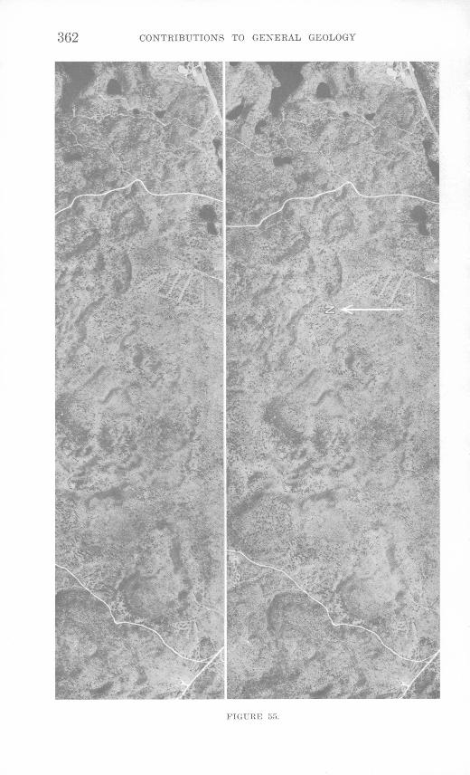
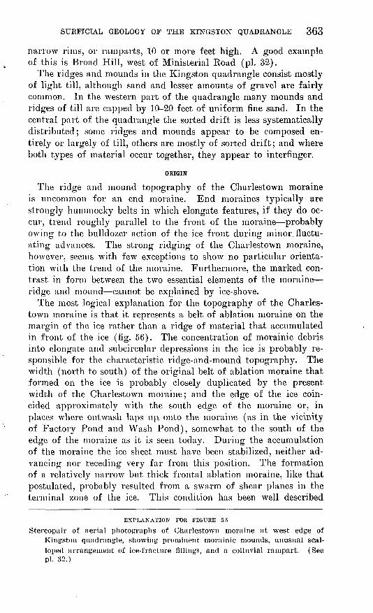
Some of the ridges are as much as 80 feet high, although many do not exceed 10 feet. Several ridges in the Kingston quadrangle range from 1 to 2 miles in length (pi. 32). Most depressions en closed by these ridges are dry, although in the east end of the moraine many of them contain perennial ponds. Aerial photographs best show the peculiar topography of the moraine; the general appearance conveyed by the complex of ridges is of a dense aggre gate of kettles that are separated by narrow septa (fig. 54). How ever, as already pointed out, closer study indicates that the essen tial morphologic and structural elements are the ridges and not the intervening depressions, or kettles.
The mounds are mostly subcircular in plan. Two or more mounds may connect to give a compound, or dumbbell-shaped ground plan. Many of the mounds have flat tops (figs. 54, 55) surrounded by
EXPLANATION FOB FIGURE 54
Stereopair of aerial photographs of east end of Charlestown moraine (The Hills), showing fracture fillings and ice-block casts. (See pi. 32.)

STJRFICIAL GEOLOGY OF THE KINGSTON QUADRANGLE 361
FIGURK r>4.
508888 O (iO
362 CONTRIBUTIONS TO GENERAL GEOLOGY
Fltil.'KK
SURFICIAL GEOLOGY OF THE KINGSTON QUADRANGLE 363
narrow rims, or ramparts, 10 or more feet high. A good example of this is Broad Hill, west of Ministerial Koad (pi. 32).
The ridges and mounds in the Kingston quadrangle consist mostly of light till, although sand and lesser amounts of gravel are fairly common. In the western part of the quadrangle many mounds and ridges of till are capped by 10-20 feet of uniform fine sand. In the central part of the quadrangle the sorted drift is less systematically distributed; some ridges and mounds appear to be composed en tirely or largely of till, others are mostly of sorted drift; and where both types of material occur together, they appear to interfinger.
ORIGIN
The ridge and mound topography of the Charlestown moraine is uncommon for an end moraine. End moraines typically are strongly hummocky belts in which elongate features, if they do oc cur, trend roughly parallel to the front of the moraine probably owing to the bulldozer action of the ice front during minor, fluctu ating advances. The strong ridging of the Charlestown moraine, however, seems with few exceptions to show no particular orienta tion with the trend of the moraine. Furthermore, the marked con trast in form between the two essential elements of the moraine ridge and mound cannot be explained by ice-shove.
The most logical explanation for the topography of the Charles- town moraine is that it represents a belt of ablation moraine on the margin of the ice rather than a ridge of material that accumulated in front of the ice (fig. 56). The concentration of morainic debris into elongate and subcircular depressions in the ice is probably re sponsible for the characteristic ridge-and-mound topography. The width (north to south) of the original belt of ablation moraine that formed on the ice is probably closely duplicated by the present width of the Charlestown moraine; and the edge of the ice coin cided approximately with the south edge of the moraine or, in places where outwash laps up onto the moraine (as in the vicinity of Factory Pond and Wash Pond), somewhat to the south of the edge of the moraine as it is seen today. During the accumulation of the moraine the ice sheet must have been stabilized, neither ad vancing nor receding very far from this position. The formation of a relatively narrow but thick frontal ablation moraine, like that postulated, probably resulted from a swarm of shear planes in the terminal zone of the ice. This condition has been well described
EXPLANATION FOR FIGURE 55
Stereopair of aerial photographs of Charlestown moraine at west edge of Kingston quadrangle, showing prominent morainic mounds, unusual scal loped arrangement of ice-fracture fillings, and a colluvial rampart. (See pi. 32.)

364 CONTRIBUTIONS TO GENERAL GEOLOGY
by R. P. Goldthwait (1951) for the Barnes ice cap in Baffin Land. In fact, the ablation moraine of the Barnes ice cap probably is a small analogue of the Charlestown moraine during its formation and, therefore, merits a brief resume here. According to Goldthwait, morainic debris is dragged up from the base of the ice to the surface along shear planes which slope back under the Baffin Land ice at inclinations ranging from 10° to 36°. The belt of marginal shear planes is as much as 450 feet wide, and behind it the surface of the ice is clean. The film of moraine, which is brought up along each shear plane and which is released from the ice by ablation, ulti mately slides down the ice slope and accumulates as a relatively thick till blanket on the margin of the ice. Some of this till slides com pletely off the ice and banks up as a colluvial accumulation against its toe. Goldthwait (1951) noted further that the clean ice just behind the shear zone, as well as the slightly dirty ice of the proxi mal part of the shear zone, melted more rapidly than the terminal ice which was insulated by the blanket of till. Consequently, at the time Goldthwait made his study, a trough had developed in the surface of the ice behind the till-covered marginal ice. Because of the differential rate of melting between insulated and noninsulated ice, Goldthwait suggested that in time this trough would deepen and the moraine-covered marginal ice would become isolated from the receding ice front. The shear-plane moraine would then form a narrow ice-cored ridge parallel to, but separated from, the re treating ice front. It may also be presumed that ultimately some ablation moraine would slump off the proximal side of this ridge to form a colluvial accumulation similar to that on the distal side.
Much of the same sort of thing probably happened in the forma tion of the Charlestown moraine, only here the process was on a much larger scale than that noted in Baffin Land. The belt of mar ginal shear planes was, for the most part, much wider and much more rock debris must have been transported to the surface of the ice than was observed in the Barnes ice cap.
The colluvial accumulations on the marginal slopes of the mo rainic ridge noted in Baffin Land are represented in the Charles- town moraine by the ridges that bound the moraine at several places on both its north and south sides and that trend roughly parallel to the ice front. These are called colluvial ramparts in this report. Excavation into the colluvial rampart that is located about three-fourths of a mile west of Perrysville exposed crudely stratified stony light till. The bedding dipped southward, parallel to the slope of the ridge, very much as would be expected for a colluvial accumulation.

SURFICIAL GEOLOGY OF THE KINGSTON QUADRANGLE 365
Most of the ridges in the Charlestown moraine, however, do not parallel the ice front and are, therefore, of a different origin. The arrangement of these ridges, when viewed in plan (pi. 32), strongly suggests systems of fractures. This is particularly well demon strated by the polygons that occur in several places most notably in the eastern part of the moraine and resemble the form com monly assumed by shrinkage cracks. The morainic ridges are, therefore, thought to have originated as fillings of fractures in the ice by morainic material. The pattern made by the ice-fracture fillings provides an unusually clear picture of the manner in which a large mass of glacial ice breaks down into separate blocks. Some of the ridges may represent crevasses that were already gaping when the ice was still active. Most of them, however, probably mark fractures that were opened later, at a time when the wastage of the ice core was well advanced. The polygonal fracturing, indica tive of contractile stresses (see Washburn, 1956, p. 850-852), sug gests that temperature fluctuations affected the ice core. Tempera ture changes may have resulted from a marked climatic deterioration or they may have been pronounced seasonal changes.
Movement of ablation moraine into the enlarged fractures was mostly by fiowage. As a result, little or no sorting occurred and most of the fillings are composed of till. Melt water accumulated in these depressions and caused local interlensing of sand and till. Where drainage of the enlarged fractures was seriously impeded by thick accumulations of impervious till, ponding took place and sub stantial thicknesses of water-sorted sediments were deposited on top of the till (fig. 56). The sand cap of some of the ice-fracture fillings in the western part of the quadrangle probably formed in this manner.
Morainic mounds probably are due to accumulation of ablation moraine in deep depressions in the ice core. As previously men tioned, many of these mounds have flat tops surrounded by low rims. The rims are similar in form and arrangement to ice-frac ture fillings and in several places are clearly continuations of ice- fracture fillings. Moreover, in The Hills, several morainic mounds have polygonal-shaped rims (fig. 54). The rims of the morainic mounds, therefore, may also be ice-fracture fillings. It is apparent, then, that many mounds spatially represent the block of ice that was outlined by the fractures responsible for the rims. For this reason, and to designate specifically morainic mounds of this origin, they are called here ice-block casts.
The transformation of an ice block into an ice-block cast neces sitates that the ice block melt more rapidly than the surrounding ice and that ablation moraine move from the adjacent ice into the resulting depression. The reason for the more rapid melting of the

366 CONTRIBUTIONS TO GENERAL GEOLOGY
ice block in relation to the surrounding ice is somewhat obscure. Possibly it is brought on by the closer initial spacing of the bound ary fractures and by their rapid enlargement. This might result in altering the relatively flat upper surface of the ice block into a cone whose sides are too steep to support an insulating mantle of ablation moraine (fig. 56, stage 4). Denuded in this way of its till cover, the ice would melt rapidly and form a depression into which till mantling the surface of the surrounding ice would slump and flow. At a later stage ponding might occur, and deltaic and lacus trine deposits would be superimposed over the till (fig. 56, stage 5). Possibly during the long and complex course of downwastage of the ice core, ice-block casts that formed early were destroyed owing to the insulating effect of the thick fill on further wastage of the underlying ice. The existing ice-block cast may, therefore, repre sent only the last of a series of two or more such accumulations, which developed cyclically with downwastage.
The rim of the ice-block cast is not difficult to explain if the reader will refer to figure 56, stages 4-6. It can be seen that if sedimentation in the ice-block depression comes to an end before the entire ice block is melted, then the ice-fracture fillings (of the boundary fractures) will be expressed on the surface of the ice- block cast after complete deglaciation because of the mirror-image effect previously mentioned (p. 358).
Whether the Charlestown moraine was deposited as a terminal moraine following an ice advance or as a recessional moraine dur ing a halt in the recession of the ice front is uncertain. No com pelling evidence that it is a terminal moraine of a major ice ad vance was found. There are, for example, no signs that the drift north and south of the moraine are different in age. The light till south of the moraine (a good exposure of which can be found in a pit on the Matunuck School road, northeast of Green Hill) shows about the same degree of weathering (or lack of weathering, for these tills are remarkably fresh) as the tills in, and north of, the moraine. Signs of ice readvance, such as superimposed tills of somewhat different aspect, or till overlying outwash, seem to be absent north of the moraine. For these reasons it seems sounder to consider the moraine as marking a halt of the ice front during recession. If this inference is correct it points to the existence of an ice front different from the ragged and ill-defined configuration that seems to have characterized glacial retreat in this region (Flint, 1929; Goldthwait, 1938; Antevs, 1939; Currier, 1941; Jahns, 1953). The Charlestown moraine represents a relatively straight and sharp ice front, much like that which probably characterized long seg ments of the Pleistocene ice sheet during its advance rather than

SURFICIAL GEOLOGY OF THE KINGSTON QUADRANGLE 367
NORTH SOUTH
Dirty bottom ice
STAGE 1 Initial development of active ice front
Shear-plane zone
STAGE 2 Stabilized front; development of ablation moraine and proglacial colluvium
STAGE 3Retreat by ice wastage; formation of ice-cored end moraine.
Formation of ice fractures
Naked ice; start of formation of morainic mound
STAGE 4 Widening and filling of ice fractures
Temporary lakes with sorted drift
STAGE 5 Ponding in undrained depressions
Colluvial rampart.
Ice-fracture fillings
Rimmed morainic mound Ice-block cast.
Colluvial rampart
Englacial moraine Till Sorted drift
FIGURE 56. Schematic north-south cross section showing development of the Charlestown moraine.

368 CONTRIBUTIONS TO GENERAL GEOLOGY
its recession. This apparently anomalous ice front can, however, be reconciled with a recessional origin of the moraine, because a straight front could have replaced the ragged front as a result of a mild increase in glacial outflow. The "live" ice, which made up all but the ragged marginal zone of the ice sheet, could then have developed a fairly straight and sharp contact in a zone of shearing with the "dead" ice of the marginal fringe. If the outflow was balanced by the wastage in this zone, the zone of shearing would have remained stationary while the marginal zone of "dead" ice to the south wasted away. Ultimately the active-ice front would have become the true ice front (fig. 56). Something of this sort could have occurred in the formation of the Charlestown moraine.
THE ABLATION-MORAINE COMPLEX OF THE NARBAGANSETTBASIN ICE
On the east, the Charlestown moraine grades into an area of low hummocks and scattered low morainic ridges. This area includes the shores of Potters and Point Judith Ponds and continues to the shores of Narragansett Bay east of the Kingston quadrangle (fig. 46). The area is underlain by a complex of sorted, poorly sorted, and unsorted drift. The west edge of the area coincides approxi mately with the west edge of the Narragansett basin ice. Sorted drift predominates on the west side of Point Judith Pond, although there are several sizable outcrops of till. The till, which is of the dark variety and grades laterally into the light till of the Charles- town moraine, seems to be in lenticular masses interstratified with the sand and gravel. Some of the gravel is very poorly sorted and is classified as washed till. The best exposures showing the in terstratified relation between the till and sorted drift are in the vicinity of Point Judith lighthouse, less than 1 mile east of the Kingston quadrangle. In the hurricane of August 30, 1954, wave cutting in the cliff north of the lighthouse exposed beds of dark till interbedded with thin sand layers and dark blue silt containing scattered pebbles and cobbles (fig. 57). Stratification is parallel to the surface of this gently sloping hill. The lowermost exposed stratum is composed of blue silt and is much distorted. These de posits, therefore, have some of the characteristics of an ablation moraine. They are here differentiated from the Charlestown moraine, which is also an ablation moraine and probably of the same age, because of the topographic difference and because of several probable differences in the mode of origin.
Why does the Charlestown moraine, in effect, spread out and be come attenuated at the edge of the Narragansett basin ice? The most logical hypothesis is that the front of the Narragansett basin ice formed a lobate projection during a stillstand, producing the

SURFICIAL GEOLOGY OF THE KINGSTON QUADRANGLE 369

370 CONTRIBUTIONS TO GENERAL GEOLOGY
Charlestown moraine (fig. 58). This lobe probably was caused by the topography of the Narragansett basin, for glacial ice tends to move toward, and thicken over, depressions. The greater thickness of ice in the basin resulted in greater outflow and, consequently, in a front
FIGURE 58. Map of the Kingston quadrangle showing location of the ice front during halt of the Charles- town moraine; area shown as covered by ablation moraines is stippled, and the gradational boundary between upland ice and Narragansett basin ice lobe is hachured.

SURFICIAL GEOLOGY OF THE KINGSTON QUADRANGLE 371
that projected as a separate lobe south of the upland ice. Thus the narrow belt of shear planes that marked the active front of the upland ice spread out over a wider zone in the Narragansett basin dee.
ABLATION MORAINE, TJNDIFFERENTIATED
An area of sorted drift and light till in the vicinity of Curtis Corner, west of Peace Dale, probably represents a relatively thin ablation moraine. The sorted drift, which is mostly medium to fine sand and poorly sorted gravel, lacks the topographic expression of ice-contact and outwash deposits. Several low ridges that are prob ably ice-fracture fillings also occur in the area. There seems little doubt that these deposits represent ablation moraine, which was dropped onto the flanks of a low bedrock hill as the ice melted. Although it is difficult to define the limits of this area of thin ablation moraine, particularly as related to the ground moraine on the southeast, a separation has been made on the basis of the pre dominance of sorted drift. The area that is predominantly till is shown on the geologic map (pi. 32) as ground moraine.
ICE-CONTACT DEPOSITS
Much, if not most, of the deposits of glacial sand and gravel in New England are classified as ice-contact deposits. They are mostly glaciofluvial in origin and were deposited between and on stagnant ice masses during the later stages of glacial wastage, when isolated blocks and tongues of ice occurred in profusion in low places and valleys (Flint, 1947, p. 133, 143-155). The deposits have a char acteristic topography formed by the subsequent melting of this ice and the accompanying collapse of the adjacent and overlying de posits. The major topographic features are kame terraces, kame plains, kame deltas, kames, eskers, and ice-fracture fillings. The shape and distribution of the former ice masses are clearly reflected in the topographic form of these deposits just as they are in the ablation moraine. Flat surfaces (like kame terraces and kame plains) mark areas that were free of ice when the uppermost strata were deposited. Depressed areas and kettles (areas that are now mostly occupied by swamp) and areas of hummocky relief repre sent places occupied by stagnant ice blocks (fig. 59). Ridge-shaped deposits may have formed by deposition in narrow passageways between ice blocks (ice-fracture fillings) or may represent deposi tion in ice tunnels and channelways (eskers and ice-channel fillings).
It is apparent that ice-contact deposits have much in common Avith ablation moraines. They differ, however, in representing a later stage of deposition when ice wastage and ice breakup was more advanced. In the Kingston quadrangle deposition continued
372 CONTRIBUTIONS TO GENERAL GEOLOGY
Mapped
Mapped as ablation moraine
/Deposited as ice-contact deposit
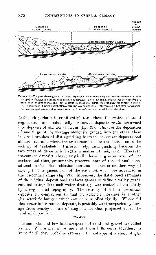
FIGURE 59. Diagram showing some of the principal genetic and morphologic differences between deposits mapped as ablation moraine and as ice-contact deposits. Note that the lateral contact between the two units may be gradaticnal and that deposits of ablational origin may underlie ice-contact deposits. (A) Cross section showing distribution of wasting ice and deposits. (B) Same as A but after deglaciation. Recent swamp deposits in depressions resulting from collapse over buried ice are also shown.
(although perhaps intermittently) throughout the entire course of deglaciation, and undoubtedly ice-contact deposits grade downward into deposits of ablational origin (fig. 59). Because the deposition of one stage of ice wastage obviously graded into the other, there is a real problem of distinguishing between ice-contact deposits and ablation moraine where the two occur in close association, as in the vicinity of Wakefield. Unfortunately, distinguishing between the two types of deposits is largely a matter of judgment. However, ice-contact deposits characteristically have a greater area of flat surface and thus, presumably, preserve more of the original depo sition al surface than ablation moraines. This is another way of saying that fragmentation of the ice sheet was more advanced in the ice-contact stage (fig. 59). Moreover, the flat-topped remnants of the original depositioiial surfaces generally define a valley gradi ent, indicating that melt-water drainage was controlled essentially by a deglaciated topography. The scarcity of till in ice-contact deposits in comparison to that in ablation moraines is another characteristic but one which cannot be applied rigidly. Where till does occur in ice-contact deposits, it probably was transported by flow- age from nearby masses of stagnant ice that projected above the level of deposition.
KAMES
Hummocks and low hills composed of sand and gravel are called kames. Where several or more of these hills occur together, (a kame field) ihej probably represent the collapse of a sheet of gla-

SURFICIAL GEOLOGY OF THE KINGSTON QUADRANGLE 373
ciofluvial sand and gravel over an ice mass of uneven form (fig. 59). Where the deposit is in the form of a solitary hillock, particu larly in an area of ground moraine (for example, 1 mile southwest of Kingston), deposition probably took place in a hole or depres sion in the ice. In the northwest corner of the quadrangle a group of low kanies, consisting mostly of sand but with some gravel, partly block the valley of the Usquepaug River.
KAME TERRACES
Terraces on valley sides made up of sorted drift and apparently not the result of river erosion are called kame terraces. These ter races may be remnants of a more widespread deposit that once blanketed the stagnant ice lying in the valley, or they may repre sent deposits that formed marginal to the ice in a narrow corridor between the ice and valley side and that may never have been much more extensive than they are now. In the Kingston quadrangle it is almost impossible to differentiate between this type of ice-mar ginal terrace and the residual terrace of an extensive superglacial out wash plain.
KAME PLAINS
Flat-topped deposits of sorted drift that rise above the surround ing level and are not attached terracelike to a valley side are called kame plains. Two examples of this feature are designated on plate 32; they occur in the Tuckertown-Worden Pond area, in the east- central part of the quadrangle.
KAME DELTAS
Flat-topped deposits of sand and gravel having the prominent foreset bedding characteristic of deltaic deposition are called kame deltas. They probably formed in temporary lakes or ponds whose sides were partly or entirely of ice. A good example of a kame delta occurs just Avest of Peace Dale. This deposit is mostly sand and gravelly sand.
ICE-CHANNEL FILLINGS
The low ridge that partly crosses the outwash plain about 1 mile northwest of West Kingston probably formed in an ice channel or an enlarged ice fracture. The ridge is composed mostly of thin- bedded sand but includes many large angular boulders and small lenses of till in the upper part. Another ridge in the area of ice- contact deposits occurs about half a mile north of Tuckertown; this ridge, however, is composed mostly of gravel. Again, this deposit may have formed in an open fracture (crevasse) in the ice or in the channel of a melt-water stream that was incised somewhat deeply in the surface of the ice.

374 CONTRIBUTIONS TO GENERAL GEOLOGY
ICE-CONTACT DEPOSITS, TJNDIFFERENTIATE5D
Ice-contact deposits are generally classified somewhat arbitrarily into several topographic categories. Actually a wide variety of surface forms occur, and many topographic units are not accu rately described by the usual terms. Thus many deposits have neither the form of a terrace, as generally understood (they may lack the relatively flat upper surface, the front scarp, or the tend ency to be elongated parallel to the valley sides), nor of a flat- topped plain, nor of the sharply hummocky topography implied by the term "kame". These deposits are, therefore, designated as un- differentiated on plate 32 because the usual terminology is not ade quately descriptive.
The broad valley fill north of Peace Dale is difficult to classify. In appearance, it is similar to an outwash plain. On the other hand, because many kettles break the central part of the fill (in the Narragansett Pier quadrangle) and because its slope suggests a certain amount of differential collapse over thin buried ice, it is included in the ice-contact category rather than in the proglacial deposits. This valley fill is a good example of the gradational boundary between ice-contact deposits and proglacial deposits (see below).
PBOGLACIAL DEPOSITS
Glacial melt-water deposits laid down in front of the main mass of wasting ice are called proglacial to distinguish them from ice- contact deposits, which were formed in close association with wast ing ice. Proglacial deposits, therefore, represent the last stage of glacial deposition and may grade into ice-contact deposits, both vertically and laterally, in the same way that ice-contact deposits may be gradational with ablation moraine. The presence of ket tles, representing buried or embedded ice blocks, in proglacial out- wash shows that even in this late stage of deposition some ice still remained.
DEPOSITS OF GLACIAL LAKE WORDEN
Drilling records and shallow auger holes in the margins of the Great Swamp have shown that uniform fine sand occurs beneath the thin cover of swamp deposits. Much, if not all, of the bottom of Worden Pond appears to be uniform fine sand, and along the southeast shores of the lake a belt of this sand is exposed without a masking cover of swamp soils. All of these sands were probably deposited in a proglacial lake, glacial Lake Worden, of which the present Worden Pond is but a shallow relict.
During the late stages of deglaciation, this proglacial lake in the ramifying basin surrounding Worden Pond probably occupied all of the present swampy area and also much of the area now desig-

SURFICIAL GEOLOGY OF THE KINGSTON QUADRANGLE 375
nated as out wash plain. The basin is strongly suggestive of a for mer lake because it is confined on the south by the Charlestown moraine, on the east by the low hummocky hills south of Curtis Corner and b_y the long northward-trending ridge at Kingston, and on the west by a northward-trending chain of low hills about 1 mile west of the Kingston quadrangle (in the Carolina quadrangle). The west rim merges with the Charlestown moraine on the south, but it is breached by the Pawcatuck River at Shannock (Carolina quadrangle). The lake was fed largely by melt waters from the north but also by scattered ice blocks from within the basin. The basin probably "silted up" relatively fast, as do man-made reser voirs that are fed by heavily loaded streams, until only a shallow residual lake, Worden Pond, remained. As previously mentioned, scattered data indicate that fine-grained sand is an important com ponent of the lake deposits. Some silt can be expected at depth in the central part of the basin. Coarser deltaic facies (medium- 'to coarse-grained sand and gravel) may also occur at depth and at the rims of the basin.
Well records (Bierschenk, 1956) show that bedrock lies below sea level under the eastern part of the basin. Therefore, as melting progressed, ponding must have taken place when the level of the ice (plus any cover of ablation and ice-contact deposits) dropped below the level of the lowest outlet of the basin. This outlet is at the east edge of Shannock, about 0.7 miles west of Kenyon, where the Pawcatuck River flows on bedrock at an altitude of about 84 feet. The next lowest spillway in the basin rim is at an altitude of about 95 feet and lies within the Charlestown moraine near its north edge, about 1 mile west of the Kingston quadrangle. Above this, the next natural spillway lies at an altitude of about 105 feet and occurs about 2 miles southwest of Wakefield. This, however, is the present topography of the basin rim; during deglaciation it must have been somewhat different. The Charlestown moraine prob ably stood higher than at present because of its ice core (fig. 56) ; and, consequently, the 95-foot spillway may not have existed. In deed, this outlet does not bear any evidence of ever having served as a melt-water channel. On the east, the moraine-covered Narra- gansett basin ice (pi. 33) also created a high barrier, which no longer exists. Therefore, the Shannock spillway must have con trolled the discharge of the basin to a lake level at least 105 feet in altitude.
The highest altitude at which sediments of probable lacustrine origin occur is about 105 feet; these are the deltaic deposits in the vicinity of Larkin Pond that are described below as outwash de posits. In the area of the Great Swamp, however, the level of the lake deposits lies mostly at about 90 feet. There are several pos-
376 CONTRIBUTIONS TO GENERAL GEOLOGY
sible explanations for the 105-foot level of the lake: (a) The outlet may initially have been ice-blocked; (b) the outlet may have ini tially been higher and narrower and was, subsequently, eroded to its present width and altitude; and (c) the level of the lake may have fluctuated seasonally.
Assessment of the probability of these hypotheses is difficult. An argument against an initial ice-block is that ice would not likely have endured in the narrow, shallow valley of the Pawcatuck River at Shannock, while the deeper basin to the east and northeast was largely ice free. Moreover, the deltaic(?) front of the outwash plain, appears to be a late feature in the filling of the lake basin. This factor is also an argument against the probability of the lower ing of the outlet by erosion as a controlling mechanism. On the other hand, seasonal fluctuations of as much as 20 feet in a glacial lake of the indicated size are not impossible. The difference be tween the peak stage of midsummer melt-water drainage and win ter drainage in glacial lakes is generally responsible for appreci able fluctuations in lake level. The magnitude of the fluctuations depends on the ratio of lake inflow to lake outflow and to storage capacity (mainly a function of area) of the lake.
The Shannock outlet, which controlled the outflow of the basin, is somewhat constricted. It is not, however, sufficiently narrow to account for a 105-foot stage unless the minimum rate of ice melting was about 3 inches per day. 1 Although this figure for melting is high (Sharps, 1951, gives 2.32 inches as the ablation rate for the Malaspina Glacier), there is no evidence that it did not occur.
Finally, formation of ice jams may be a cause of extreme fluctua tions in lake level and may have occurred in glacial Lake Worden. Spring floods entering the still frozen lake may have caused frag mentation of the ice crust, and the accumulation of ice floes in the narrow outlet may have brought about temporary damming.
1 A fair approximation of the discharge (in cubic feet per second) of the Shannock outlet can be computed by making use of the formula for a rectangular broad-crested weir (Vennard, 1947, p. 214),
where Q is discharge, 6 is width of rectangular channel, g is acceleration of gravity, and H is height of water over sill. The weir formula shows that at the lake level of 90 ft, about 500cfs would flow through the outlet making use of the present outlet profile ; at the lake stage of 95 ft, about 2,400 cfs; and at the lake stage of 105 ft, about 5,000 cfs. Although the formula does not quite pertain to the shallow asymmetric V-shaped cross section of the Shannock outlet, values that probably are not more than 25 percent in error can be derived by making rectangular equivalents of the real cross section.
Some inflow figures may be worth mentioning for comparison purposes. If an ice-covered area of 100 sq mi with drainage into the lake is assumed (this area includes all exposed ice surfaces sides of crevasses and sides of isolated ice blocks as well as horizontal surfaces) and if the ice melts at a rate of 1 in. per day, melt waters would flow into the lake at a rate of about 2,700 cfs.
The area of the inferred lake would be about 9 sq' mi.

SURFICIAL GEOLOGY OF THE KINGSTON QUADRANGLE 377
OUTWASH PLAINS
Outwash plains are the broad flood plains of melt-water streams; they are underlain mostly by sand and gravel. The outwash plains in the southern part of the quadrangle were probably deposited during the halt of the ice front along the Charlestown moraine and were fed by melt water coming from the upland ice to the north and from the Narragansett basin ice to the east. This outwash is relatively thin (about 15 feet or less) where it laps onto the low areas of ground moraine in the central part of the quadrangle.
The outwash plains in the northern part of the quadrangle prob ably overlie both ice-contact deposits and deposits of glacial Lake Worclen. The deposits were mainly derived from ice to the north. The melt-water streams probably built deltaic projections out into the lake. In the vicinity of Larkin Pond, the outwash plain ends in a low digitate scarp that is probably the front of such a delta. It is thought that this outwash plain was deposited when glacial Lake Worden stood temporarily at a relatively high stage of about 100 or 105 feet. On the other hand, there is no evidence for at tributing a deltaic origin to the south end of the outwash plain in the Usquepaug valley in the western part of the Great Swamp.
At the north edge of the quadrangle, the outwash in the Chipuxet valley is composed predominantly of horizontally bedded gravel. It becomes increasingly fine grained toward the south and at the edge of the Great Swamp it apparently grades entirely to sand. A water well just northwest of Larkin Pond penetrates 125 feet of sand overlying gravel. Much of this sand is probably deltaic in origin and the gravel may represent buried ice-contact deposits.
POSTGLACIAL DEPOSITS
SWAMPS
Swamps occur where the water table is at, or slightly above, the surface during most of the year. Most streams in the quadrangle flow on swampy flood plains. Dark-colored organic clay, silt, or sand, and in places peat, underlie most of the swamps shown on plate 32. These organic deposits are varied in thickness and gen erally overlie glacial sediments. Thus, the Great Swamp and the other smaller swamps in the Worden Pond area probably overlie the deposits of glacial Lake Worden. Data on the thickness of swamp deposits in the Great Swamp are lacking, but in all prob ability the deposits do not exceed a maximum of 25 feet and may average less than 5 feet. Because of waiter-table fluctuations, the contact between swamps and glacial deposits is not well marked. Much of the Great Swamp, particularly around the perimeter, is characterized by firm, dry footing during most of the year. The outline of the perennially undrained boggy ground takes the form
378 CONTRIBUTIONS TO GENERAL GEOLOGY
of a very complex dendritic pattern over much of the area and is somewhat simplified as shown on plate 32.
The coastal swamps, or salt marshes, that fringe the salt ponds are also underlain in places by organic-rich fine-grained sediments, ranging from clays near the outlet of Point Judith Pond to dark- colored sandy silt adjacent to the ponds toward the west. At some places the la}7er of black organic sediment is only a thin surface veneer, less than 1 foot thick, overlying littoral sands. These marshes are alternately flooded and exposed by the tides. Where peat occurs, it is composed largely of the distinctive grasses of the coastal salt marshes, particularly the salt grass Spartina patens and the common salt thatch Spartina stricta. Fresh-water peat, under the salt peat of some of these coastal marshes, has been found in foundation borings and by dredging.
LITTORAL, DEPOSITS
The beach area of the south shore consists of three separate units: (a) beaches, (b) foredunes, and (c) sand aprons.
BEACHES
During periods of normal surf all the beaches are composed of sand. At places, however, where beaches front on glacial gravels, the beach sand overlies very cobbly sand. This cobbly substratum becomes exposed during high surf, when the sand cover is washed away. Stretches of beach with cobbly foundations include the beach fronting Green Hill, Browning Beach, and Matunuck Beach. In addition, the beach at Green Hill contains numerous boulders, as much as 8 feet in diameter, that are probably derived from the till which composes this low hill. The barrier beaches that form the south shores of the salt ponds probably are sandy to some depth.
The beach at Sand Hill Cove consists predominantly of fine grained micaceous quartz sand that is derived from the drift of the Narragansett basin ice. Beach sands west of Jerusalem are pre dominantly medium to medium coarse grained, reflecting their deri vation from drift originating in the coarsely crystalline rocks of the uplands rather than the finely crystalline metasedimentary rocks of the Narragansett basin.
Beaches are eroded during storms; in general, the south shore beaches prograde during periods of normal surf. Because storms are almost as frequent and violent in the summer as they are in the winter, beach erosion and beach construction do not alternate with a strictly seasonal rhythm as they do on many coasts.
FOREDUNES
Behind the beach at many places is a long low dune or a narrow belt of small dunes. These dunes are generally less than 10 feet

SURFICIAL GEOLOGY OF THE KINGSTON QUADRANGLE 379
high, although at a few places such as at Jerusalem, east of Galilee, and at one point in Charlestown Beach the tops of these dunes range from 15 to 20 feet above the beach berm. No foredune oc curs between Matunuck Point and Jerusalem; one is developed only intermittently at Charlestown Beach, where it is often breached by storm surf. The foredune is built of beach sand that is blown landward; foredune sand is, therefore, somewhat similar in tex ture and composition to the adjoining beach sand. Exposures of the internal structure of these dunes show that they are thinly strati fied with the strata generally dipping ocean ward. This suggests that they are mostly built up by accretion on the beach side and do not, like some dunes, migrate to the leeward.
SAND APRONS
High storm waves may breach, or top, dunes and carry large quantities of beach and dime sand shoreward. This sand comes to rest in the salt pond behind the barrier beach or on the landside of the foredunes where it forms a sand apron. This apron, which is simply a flat or very gently sloping expanse of sand, grows land ward with each major storm; thus its contact with other deposits to the north is continually changing.
As previously mentioned, the disappearance of glacial ice from the Kingston quadrangle did not follow a simple pattern of retreat from south to north. There is enough evidence to reconstruct the distribution of the main masses of stagnant ice and to correlate these with associated deposits. Plates 33 and 34 depict the general pattern of deglaciation and the depositional sequences of the drift, respectively. These maps are only approximate, for the main con cern here is with continuous and interrelated events that are not readily divisible into discrete stages.
Plate 33 shows the ice cores of the two large ablation moraines the Charlestown moraine and the ablation moraine of the Narra- gansett basin ice. These cores probably endured even after the ice had entirely melted at least several miles to the north and north west. The existence of this stagnant ice core is not based on glacio- logic principles alone. Two independent lines of evidence also sug gest its former presence: (a) the absence of melt-water channels across these moraines; and (b) the probable origin of the ice-contact deposits in the vicinity of Tuckertown Road.
The absence of melt-water channels across the moraines would seem to be an anomalous situation, for it is clear that large vol umes of melt water must have drained seaward between the time the glacier began to recede from the Charlestown moraine and the

380 CONTRIBUTIONS TO GENERAL GEOLOGY
time the Pawcatuck channel was cleared of ice, permitting westward drainage to the east end of Long Island Sound. The Charlestown moraine, notwithstanding the apparent necessity of drainage across it, was evidently nowhere overtopped by melt water even though there are low sags in its crestline and, about 2 miles west of the Kingston quadrangle (in the Carolina quadrangle), there is a nar row valley that extends across the entire moraine. This narrow valley is the most likely of several possible drainageways, but there is little indication that it actually functioned as such. It is only about 100 feet wide and does not show signs of having been scoured by a large melt-water stream.
The explanation for the seemingly anomalous hydraulic condi tion of drainage without channelways most probably is that the drainage went under rather than over the ablation moraine, and that it did this by way of the ice core, emerging as flowing springs on the south side of the moraine. This could have occurred in the early stages of the development of the moraine when it was still a relatively thin shell overlying thick dirty ice. Glacial ice is very pervious because of its fractures and, hydrologically, is similar to cavernous dense limestone. The location of some of these early trans-ice springs is possibly marked by Fresh Pond and Factory Pond in the Kingston quadrangle, and Cross Mill Pond and King Tom Pond in the Carolina quadrangle. The topography of the Charlestown moraine to the north of these ponds furnishes evidence for this interpretation. Plate 32 shows that directly to the north of each pond there is either a well-marked sag in the crest of the moraine or else particularly deep kettles. Both kettles and crestline sag represent a deficiency of material in the moraine. North of Fresh Pond, for example, the moraine has several large deep kettles (containing perennial ponds). North of Factory and Cross Mill Ponds there are sags in the crestline of the moraine and several deep kettles. The same is true of the moraine behind King Tom Pond, but the sag here is more pronounced and consists of the nar row valley that cuts across the entire moraine. The deficiency of morainic material represented by these sags, deep kettles, and trans verse valleys is probably the result of trans-ice drainage having flushed away morainic debris from the ice tunnels and crevasses that served as drainageways.
In the early stages of the glacial recession from the Charlestown moraine, the ablation moraine, therefore, must have been an ineffec tive earth dam. Later, when the ice core had shrunk in size and the shell of ablation moraine had thickened, the Charlestown mo raine became an impermeable barrier. It is therefore apparent that glacial Lake Worden could not have come into existence until trans-ice drainage had been reduced to a sufficiently low level. The

SURFICIAL GEOLOGY OF THE KINGSTON QUADRANGLE 381
lake must have developed slowly, probably rising to higher levels each year as the trans-ice drainage was gradually pinched off. Dur ing this formative period, the seasonal variations in lake level must have been extreme, and it is likely that the lake was drained almost dry each winter. The highest level of the lake the level controlled entirely by the discharge through the Pawcatuck valley therefore, probably occurred when the ice core of the ablation moraines shrank to some critical dimension and no further trans-ice drainage, other than the normal slow ground-water movement, was possible.
Delayed melting of the ice under the ablation moraines is also indicated by the ice-contact deposits in the vicinity of Tuckertown Road. These deposits were probably derived largely from the Narragansett basin ice. This is shown by their considerable con tent of sand and gravel derived from rocks of the Narragansett basin types and also by their depositional gradient, which appears to have sloped down to the west or southwest, away from the Nar ragansett basin ice. The head of these deposits (the kame terrace about 1 mile west of Wakefield) is now hanging 75 feet above the ablation moraine of this ice. During the deposition of the ice- contact deposits, the Narragansett basin ice, covered by ablation moraine, must have stood as a broad expanse whose west edge formed a wall against which ice-contact deposits were laid down (fig. 60).
Unlike the thick ablation moraines and their ice cores the abla tion moraine of the Curtis Corners area was thin and, therefore, may not have seriously delayed melting of the underlying ice (pi.33).
The deglaciation and sequence of deposition in the northwest cor ner of the Kingston quadrangle is more difficult to determine be cause a minor halt of the ice front may have occurred here. The group of kames in the Usquepaug valley and the ice-channel filling that projects above the level of the outwash plain south of Barber Pond may possibly mark a narrow end moraine. It is pertinent that a very bouldery deposit having the appearance of a small end moraine, occurs just a few hundred yards north of the Kingston
Post Road and EAST Tuckertown Road intersection igo i
I Sea level
FIGURE 60. Cross section showing relation between stagnant ice and drift at east edge of Narragansett basin ice during glaciation. Present ground surface and inferred bedrock surface are also shown. Azi muth of profile is N. 83° W.; line of profile passes through intersection of Post Road and Tuckertown Road about half a mile southwest of Wakefield. Vertical exaggeration 13.5X.

382 CONTRIBUTIONS TO GENERAL GEOLOGY
quadrangle along the east side of the Chipuxet valley (Power, 1957). A pause in the retreat of the ice margin possibly was responsi ble for these features. If this interpretation is correct, the ice front has left only scant signs of its presence between the kames in the Usquepaug valley and the ice-channel filling on the east. Per haps it reposed against the lower flanks of the intervening bedrock hill. The interpretation of a halt of the ice front and of a small end moraine along this line is shown in plates 33 and 34.
FEATURES OF PROBABLE LATE GLACIAL AGE
EOLIAN MANTLE
A thin surface deposit of unstratified fine sandy silt occurs at many places. This deposit is patchy in distribution, although probably more than half the quadrangle is blanketed by it. It overlies all types of Pleistocene deposits and seems to be thickest on lower slopes, in hollows, and other protected places, although this relationship is not invariable. Because of the difficulty in delimit ing the patchy occurrences of this material, it is not shown on the map. The deposit varies in texture from fine sandy silt to silty sand, with the latter apparently confined to places where medium sand is abundant in adjacent or underlying deposits. The deposit is poorly compacted and has a negligible plasticity. Generally it is yellow brown, grading into gray or mottled gray and brown beneath about 2 feet. It averages between 2 and 3 feet in thick ness; 5 feet is the maximum thickness noted in the Kingston quad rangle. In some places the eolian mantle contains scattered boulders that tend to be concentrated at the surface. Embedded cobbles and pebbles are commonly wind faceted and polished.
The silty mantle is probably wind deposited. By analogy with some loessial deposits in other parts of the world, it may be de duced to have formed in close proximity to the receding ice front. Evidence described below shows that permafrost conditions prob ably existed during or after its deposition. In spite of the antiquity of most of the mantle, some wind drifting of silt and sand has undoubtedly continued to the present time on exposed slopes. Ven- tifacts are also being cut today. For example, pebbles of black argillite of Carboniferous age in Sand Hill Cove beach have been observed by the writer to show the effects of sandblast action after only several months of exposure.
Concentrations of boulders on the surface of the silt, as can be seen in the sides of a gravel pit about half a mile east of Hundred Acre Pond near the north edge of the quadrangle, probably result from either of two processes: (a) Some may have been raised from the base of the silt by ground ice, as described by Taber (1943, p.

SURFICIAL GEOLOGY OF THE KINGSTON QUADRANGLE 383
1452-1456) ; (b) others probably migrated by solifluction along the surface from outcrops of bedrock and till in higher ground.
POSSIBLE PERMAFROST
During or after the deposition of the eolian mantle, deep ground ice must have formed in the area. Evidence for this is varied. About a dozen wedge structures, consisting of eolian silt penetrating deep into underlying gravel, were observed by the writer and J. P. Schafer in the gravel pits north of Peace Dale (just east of the King ston quadrangle) and also in the pit about half a mile east of Hun dred Acre Pond, near the north edge of the Kingston quadrangle. Several wedges descended vertically to at least 9 feet below the sur face. They extend through sand, gravel, and silt, whose bedding bends downward at the margins of the wedges. The wedges range from 12 to 18 inches in width at the top, where they join the eolian silt mantle, and taper to a fraction of an inch at depths ranging from 7 to 9 feet, where their continuity was obscured by thick slump on the pit floor. In shape, they strongly resemble permafrost ice wedges similar to those described by Leffingwell (1919) and Taber (1943).
Deep ground ice is also indicated by the presence of a freshly rifted granite boulder that originally lay at least 4-9 feet beneath the sur face (fig. 61). This boulder is exposed in a gravel pit a few hundred
FIGURE 61. Frost ri of ,Snm
en boulder, probably indicating (loop ground ice. in snivel pit north Harbor. From 1 to 2 inches of gravel till the fractures.

384 CONTRIBUTIONS TO GENERAL GEOLOGY
yards north of Snug Harbor in the ablation-moraine complex of the Narragansett basin ice. The boulder, which consists of unweathered medium-grained pink granite, is about 8 feet wide and is broken by a T-shaped fracture. The three large pieces into which the boulder was split by the fracture have been spread apart by as much as 2 inches, forming a space now filled with gravel. Thus the top half of the boulder must have been uplifted at least 2 inches. The only mechanism that seems capable of both splitting the boulder and prying the pieces apart in this way is ground ice. The ice must have extended at least 9 feet below the surface, for this is the estimated depth of the base of the boulder beneath the original pregravel-pit surface.
These features suggest that either permafrost or very deep annual freezing occurred in the Kingston quadrangle. It is not certain that the depths of frost involved necessarily indicate perennially frozen ground. Hopkins and Sigafoos (1951, p. 61) note, for ex ample, that summer thaws of ground ice on Seward Peninsula, Alaska, reach depths as great as 10 feet. The development of well- formed ice wedges in one winter season, however, is unlikely, and the ice wedges probably indicate true permafrost.
Some parts of the area have a microrelief suggestive of the perma frost mounds of the Fairbanks area, Alaska, described by Pewe (1954). Low mounds, generally 3 feet or less in height and shallow swales that in places crudely inscribe a polygonal pattern, can be seen on aerial photographs of cleared fields located on silt-mantled outwash. Examples of beaded drainage, resembling those de scribed by Pewe (1954) as characteristic of a thermokarst topog raphy, also occur, most notably in the ablation-moraine complex of the Narragansett basin ice, about 2 miles south of Wakefield and east of Point Judith Pond in the vicinity of Point Judith (Narra gansett Pier quadrangle).
The deep ground ice was formed subsequent to the deposition of most, if not all, of the outwash and either contemporaneous with, or subsequent to, the deposition of much of the eolian mantle. The climate was probably periglacial, although the possibility of a cli mate severe enough to produce permafrost and at the same time produce rapid glacial recession is questionable. It is possible, how ever, that the glacial recession was due more to a lack of nourish ment a trend toward greater aridity in the central parts of the ice cap than to a general amelioration of temperature.
AGE OF THE DRIFT AND POSSIBLE MULTIPLE GLACIATION
No indication of multiple glaciation has been recognized in the Kingston quadrangle or elsewhere on the mainland in this vicinity. However, drift of 2 and possibly 3 different ages is believed to be exposed in the sea cliffs on Block Island, about 10 miles south of
SURFICIAL GEOLOGY OF THE KINGSTON QUADRANGLE 385
the Kingston quadrangle. Woodworth and Wigglesworth (1934) claimed evidence of 5 and possibly 6 glaciations in these sea cliffs. The youngest of the drifts probably correlates with the drift in the Kingston quadrangle. If the interpretation of the multiple drift on Block Island is correct, the Kingston quadrangle was glaciated at least twice, but deposits from only the most recent glaciation are extant or exposed.
Older drift in the Kingston quadrangle is indirectly indicated by the lack of conformity between the crest of the Charlestown mo raine and the underlying bedrock surface. If the mode of origin of the Charlestown moraine is correct as previously described (p. 363), the thickness of the moraine should be relatively constant along a profile paralleling the ice front. The crest of the moraine, therefore, should reflect the surface of the foundation on which it was deposited. However, according to interpretation based on well data, there is little correlation between the crest of the mo raine and the bedrock surface at the east end of the moraine. For example, bedrock at Perryville occurs at an altitude of about 15 feet (Bierschenk, 1956), and west of Ministerial Road at an altitude of about 30 feet. Less than 1 mile east of here, in The Hills, the surface of the bedrock drops about 130 feet, to 100 feet below sea level, although the crest of the moraine drops no more than 50 feet. Therefore, 50 to 75 feet of older drift possibly underlies the Charles- town moraine here. On the other hand this hypothetical submo- rainal drift may be simply subglacial till of the last ice or even outwash that was deposited during the advance of the last ice.
Differences in compactness of light till cannot of itself be con sidered a sign of differences in age. The exceedingly compact till of the New York, New Haven, and Hartford Railroad cut at the north end of Great Neck (p. 347), is possibly a subglacial till of the same age as the less compact variety.
Differences in compactness of dark till is also an unreliable age criterion. For example, a dark till found a quarter of a mile south of Scarborough beach, which lies about 1 mile east of Point Judith Pond was excavated and then dumped along the shore in the course of recent construction. It has become more compact in a few years than the same till in its undisturbed state. This is evident in the low sea cliff here, where the reworked till has with stood wave erosion better than the undisturbed till and forms a small projection of the shoreline.
Differences in iron staining and content of decomposed pebbles between the light and dark tills does not signify a difference in age of the two tills. These features, which in other places might be considered an indication of the greater age of the dark till, can be
386 CONTRIBUTIONS TO GENERAL GEOLOGY
interpreted simply as expressions of the higher content of readily decomposable sulfides that characterize the rocks of the Narra- gansett basin.
The Charlestown moraine is generally believed to be an end mo raine of early Wisconsin ice, specifically of lowan and Tazewell age (Antevs, 1953; Flint, 1953; Flint and others, 1945; MacClin- tock, 1954, fig. 2); Denny (1956), however, suggests a late Wis consin age correlative with the Valley Heads moraine of central New York. The basis for assigning an early Wisconsin age to the Charlestown moraine varies somewhat, but evidence to the north of the moraine indicates a long and varied history of glacial retreat, halts, and even ice readvance since the ice occupied the southern coast of New England. Adequate time for all of these events has been allowed by assigning the southern New England deposits to the early Wisconsin.
This is a somewhat unsatisfactory basis on which to date glacial deposits. Dating by radiocarbon analysis of contemporary (or nearly contemporary) carbonaceous material from the drift is the best method at present for determining the absolute age of the deposits. Unfortunately only few radiocarbon dates from New England are available, and their significance in illuminating the glacial story is not entirely clear. The area closest to the Kingston quadrangle in which a radiocarbon date has been determined is Block Island, where an age of 12,090 ±200 years was obtained for wood resting on fresh, unweathered till at the base of a bog deposit. The sample (USGS W-255) was in contact with the till at the base of 8 feet of alternate wood and peat layers that filled a small kettle. The section was exposed in a freshly eroded cliff by the hurricane of August 30, 1954. The till on which the sample rested is the most recent of several drifts exposed on Block Island and probably is correlative with the drift in the Kingston quadrangle.
If it is assumed that the radiocarbon sample from Block Island represents the earliest plant growth following the deposition of the underlying till, and if the interval between deposition and plant growth was short, then there is a basis for dating the latest drift on Block Island. This would be a late Gary age for, according to Meyer Rubin (written communication), the maximum of the Gary substage in the Central States occurred 14,000-15,000 years ago. Unfortunately there are indications that the above two assumptions may not be justifiable:
1. Complete sections of New England bogs show that the first plants to establish themselves following deglaciation were generally herbaceous types. The absence of a basal stratum of nonwoody peat in the Block Island kettle indicates that an incomplete post-

387
glacial section may occur in the kettle.2 This hypothesis is given some support by evidence of permafrost in the Kingston quad rangle, only a few miles to the north.
2. Radiocarbon dates from Totoket bog in the vicinity of Mid- dletown, Conn. about 55 miles west and 25 miles north of Block Island show that this area was free of ice more than 13,500 years ago (E. B. Leopold, written communication). This is 1,400 years earlier than the Block Island date. Offhand, this suggests that Block Island must also have been cleared of ice 13,500 years ago. We cannot be certain of this, however, for it has been shown in the study of the Kingston quadrangle that the ice front during retreat was marked by at least one lobate projection. Block Island was covered by the Narragansett basin lobe, and perhaps the difference between the radiocarbon dates of the Block Island and Totoket bogs is a measure of the lag in the recession of this lobe.
Although the full meaning of the Block Island date awaits clari fication, the evidence at hand suggests that this date may be too recent by an interval of periglacial arctic climate (represented by permafrost). Whether this interval consisted of one thousand or several thousand years is not certain. All that can be said for the age of the Charlestown moraine and the drift of the Kingston quadrangle is that it is younger than the Block Island drift. This age difference may be relatively small, however; and present data suggest that the Charlestown moraine may be late Gary in age.
POSITION OF SEA LEVEL
No evidence of sea levels higher than the present one was rec ognized in the Kingston - quadrangle or in adjacent coastal areas. The flanks of the low morainic hills adjacent to the shore areas show no sign of marine erosion other than the cliffs formed at pres ent sea level. Beach cobbles and sand are scattered sparsely along the shore to heights of as much as 20 feet above high tide, but these probably have been tossed by storm waves. The hurricane of August 30, 1954, strewed beach material to this height and also caused severe gullying and local erosion to even greater heights as a result of the voluminous backwash of the breaking waves.
The lack of evidence for higher sea levels implies either (a) that since glacial recession, sea level has never been higher eustatically than at present, or (b) that if sea level was higher, subsequent crustal subsidence has equaled or exceeded the altitude of the higher sea level stand. It is difficult to appraise whether or not appreci able crustal subsidence occurred in late Quaternary time along this
2 It is difficult to see why this kettle would not be floored with a complete postglacial section. Perhaps the basal herbaceous plant remains were entirely oxidized prior to the deposition of the woody layer, or per haps they were removed in some way. It is also possible that the kettle was formed thousands of years after deglaciation as a result of the very slow melting of the buried ice block that formed it.

388 CONTRIBUTIONS TO GENERAL GEOLOGY
coast because of the difficulty of disentangling the evidence from the effects of eustatic sea level changes. Mariner (1949) has shown by tide-gage records that sea level has risen 0.41 feet in 22 years (1925-47) at Boston and 0.45 feet in 45 years (1893-1947) at New York. At present, however, it is impossible to say what part of this sea level shift is due to crustal subsidence and what is the result of worldwide sea-level changes.
If sea level during Quaternary time fluctuated eustatically in syn chronization with the waxing and waning of glaciers, then at the time the Kingston quadrangle was covered with ice, as well as dur ing deglaciation, sea level must have been well below its present datum and the shoreline, therefore, was far to the south of the present one.
POSTGLACIAL EROSION
Erosion has not substantially altered the constructional form of the glacial topography. Stream erosion and gullying have generally been slight since the deposition of the drift. The flanks of the till-covered ridge on which Kingston is located are scored by sev eral shallow valleys which have probably been incised postglacially. Both Beaver River and Chipuxet River have cut down into the outwash plains on which they flow. - This is clearly indicated in the Chipuxet River by a series of shallow scour channels on the right bank northwest of Larkin Pond, several feet above the pres ent swampy flood plain. Similar shallow scour channels can be seen at several places on the banks of the Beaver River. Sheet erosion and some soil creep have probably occurred on steeper slopes, but these too have only slightly modified the original depo- sitional forms. Several centuries of cultivation has probably effaced the most delicate microrelief, like that which might have resulted from permafrost. To a certain extent wind action has redistributed some surface deposits, although, except for sand dunes behind the beaches, no dunes were recognized in the quadrangle.
SHORELINE CHANGES
The shoreline has undergone a long history of shifting, although recession appears to have been dominant. The beaches have en croached onto the salt ponds, outwash, and ablation-moraine com plex lying to the north. This is evident at several places. Off Matunuck Point several broad bouldery pavements lying at, and a bit below, low tide extend several hundred yards from shore and mark former low hills of the ablation moraine complex that have been planed off by recent wave erosion. A thin layer of marsh silt exposed at the base of the foredune in the side of the narrow breachway of Card Ponds shows that the beach there has clearly encroached onto the salt marsh. Similar stratigraphic evidence of

SURFICIAL GEOLOGY OF THE KINGSTON QUADRANGLE 389
beach recession over former coastal swamps was noted at Watch Hill, about 13 miles wrest of the Kingston quadrangle.
Shoreline changes since the early coastal survey of 1839 are sum marized by the [U.S.] Beach Erosion Board (1950, p. 18) :
Marked accretion of the shore line prior to construction from 1891 to 1914 of the breakwaters forming the Harbor of Refuge has been followed by severe erosion until the net result today is a shore line very similar to that of 1839. Permeable groins built by the State of Rhode Island in 1939 one mile east of the entrance to Point Judith Pond failed to stop erosion at that point. The offshore contours show a general retrogression prior to 1909 and accretion since that date. The Jerusalem shore line shows accretion at the west break water, just west of the inlet to Point Judith Pond. This accretion is not as pronounced as might be expected, much of the material passing through the pervious portion of the breakwater into the inlet and the pond. Erosion toward the west limit of the Jerusalem Beach area is quite marked.
In general, along the south shore east of Watch Hill Point to the west breakwater at Point Judith Harbor the mean high-water line shows surpris ingly little change from 1839, the date of the earliest survey, to 1909. The reliability of the 1839 survey is subject to question. However, from 1909 to 1946, there appears to have been a general recession of the shore line varying up to 200 feet. The location of Quonochontaug Inlet has not changed. A slight migration westward is indicated at Weekapaug breachway by compari son of the 1839 and 1946 surveys. The offshore contours show a general slight recession from 1882, the date of the earliest survey for most of this area, to
> 1946.An exception to the foregoing general statements as to the relative stability
of the shore in this area is the condition existing from Matunuck Point east ward to the breakwaters of the Point Judith Harbor of Refuge. Here the shore line and offshore depth contours have retreated 500 feet or more, ex cept within about 1,000 feet of the west breakwater where accretion has occurred * * *.
The hurricane of August 30, 1954, occurred during high tide and resulted in unusually heavy damage. Most sand beaches were pushed back from 25 to 50 feet (fig. 62), and much of the sand was appar ently carried landward and dropped as sand aprons. The lower foredunes were topped and destroyed, while the higher ones were washed away on their south, face. The small sand islands in Point Judith Pond were reduced by as much as 10 feet on both their
1 north and south sides, presumably owing first to the onrush and then to the backwash of the wave of high water that surged into the pond.
ENGINEERING GEOLOGY
The physical properties of the major types of earth materials - that occur in the quadrangle can be assessed in a general way for
purposes of engineering construction.
LIGHT TILL
Light till, because of its good gradation but relatively low con- ^ tent of clay and fine silt, makes excellent general fill, highway sub-

390 CONTRIBUTIONS TO GENERAL GEOLOGY
FIGURE 62. Shore erosion east of Matunuck Point, R.I., resulting from the hurricane of August 30, 1954. Before the storm, the beach had terminated at a gravel cliff that was "protected" by the pile bulkhead.
base, subgrade, and surfacing if the large stones can be separated economically. It apparently is only slightly affected by frost heav ing. Light till makes a strong foundation material capable of supporting relatively heavy loads. For most engineering purposes it would be considered an impermeable soil.
DARK TILL
The physical properties of dark till are generally similar to those of light till. Dark till is, however, somewhat more compact and, therefore, more difficult to excavate, especially with hand tools; an exception is the very compact light till that occurs in the north end of Great Neck (p. 347). Dark till tends to be somewhat less stony than light till. Its shearing strength is high, and it appar ently has the property of substantial thixotropic hardening on re molding (p. 385; Ackermann, 1948). It is more impermeable than light till, although some drainage may occur along fractures.
Inasmuch as dark till in the Kingston quadrangle is interbedded with, and underlain by, beds of gravel, sand, or silt, its foundation properties may be much affected by these deposits. Thorough sub surface exploration, including deep borings, is advisable in consid ering this material for foundation for heavy structures.
SORTED DRIFT AND WASHED TILL
The engineering properties of gravel are very different from those of very fine sand and silt; however, all these gradational types are
SURFICIAL GEOLOGY OF THE KINGSTON QUADRANGLE 391
included in the category of sorted drift. Careful investigation of a site is recommended for construction on sorted drift, because all types of gradation occur in interstratified sequences. This is true of ablation-moraine as well as of ice-contact and proglacial deposits.
Gravel and washed till generally make a stronger and more per meable foundation than sand. Likewise, these materials are pref erable as general fill and as road subgrade or road surfacing. Gravel from the ablation moraine of the Narragansett basin ice is generally less desirable than gravel derived from the upland ice because of its higher content of soft or readily decomposable rock. This is particularly true of gravel to be used for concrete aggre gate, because the iron sulfides in the Narragansett basin drift may cause unsightly iron staining.
The resources of the quadrangle in sand and gravel suitable for rim-of-bank fill and road subgrade are very large. The ice-contact deposits north of Peace Dale and the outwash south of the Charles- town moraine generally appear to have a higher gravel content than the more sandy outwash in the West Kingston area. On the other hand, the gravel south of the Charlestown moraine is prob ably too thin in many places for large-scale commercial extraction. A thorough investigation of thickness of the gravel and depth to water table should be made before opening gravel pits in this area. The gravel along the shores of Point Judith Pond is generally sub ordinate in thickness to sand with which it is interbedded. It is fairly high in soft graphitic and micaceous rocks of the Narra gansett basin and is, therefore, less desirable for concrete aggregate than gravel of the upland drift.
White, fine to medium-fine sand that is possibly suitable for plas ter sand is found in many deposits of outwash. Two places where such sand is exposed are in the pit south of Asa Pond, northwest of Peace Dale, and in the pit half a mile west of the entrance of the access road to the Great Swamp Fight site.
Silt is relatively scarce in exposures of either outwash or abla tion moraine. It may occur at depth, however, and quite possibly is fairly thick beneath the Great Swamp in the deposits of glacial Lake Worden. Silt generally makes a poor foundation material for most types of structures. It tends to frost heave excessively and thus makes an undesirable road subbase. Silt generally has a relatively low shearing strength and is an unreliable foundation material for heavy structures. Foundation investigation for heavy structures on proglacial and ice-contact deposits as well as on the ablation-moraine complex should, therefore, investigate with suitably deep borings the possibility of the occurrence of interstratified silt.

392 CONTRIBUTIONS TO GENERAL GEOLOGY
EOLIAN MANTLE
Eolian mantle is undesirable as a foundation material, but it commonly is thin enough not to affect most foundations; it should be removed where especially thick, even under light footings. Eo lian mantle also is undesirable as road subsurface because of its susceptibility to frost heaving and should be entirely removed in the grading of roads.
SWAMP DEPOSITS
The difficulty inherent in building on swamps needs no extended comment. Firm footing normally is obtained only by penetrating the organic swamp soils and reaching the underlying glacial depos its. In foundations this is usually done with piles; in road build ing, by displacing the organic sediments as the road fill is built out. Fortunately, most of the swamp deposits in the quadrangle are probably very thin and are readily removed by scraping or dis placed by fill.
Peat has been used locally in the stabilization of road-cut slopes. It is placed to form a topsoil blanket and after suitable liming supports a good growth of grass.
Sand from the littoral deposits is too well sorted to be used as concrete aggregate without considerable admixing with other grain sizes and washing to remove salt. If used as a fill beneath struc-
O
tures subject to vibrations, special care should be taken to compact the sand prior to construction, otherwise excessive settlement may occur. The littoral sand is probably nowhere more than 30 feet thick; and in Green Hill, Browning, and Matunuck beaches it forms only a thin surface veneer over glacial gravel and till.
REFERENCES CITED
Ackermann, Ernst, 1948, Thixotropie und Fliesseigenschaften feinkorniger Boden: Geol. Rundschau, v. 36; translation by Nathan, H. A. G., 1950, Thixotropy and flow properties of fine-grained soils; Canada Natl. Re search Council [Ottawa] Translation TT-150, 29 p.
Antevs, Ernst, 1939, Modes of retreat of the Pleistocene ice sheets: Jour. Geology, v. 47, p. 503-508.
_____ 1953, Geochronology of the deglacial and neothermal ages: Jour. Geology, v. 61, p. 195-230.
Bierschenk, W. H., 1956, Ground-water resources of the Kingston quadrangle, Rhode Island; Rhode Island Devel. Council, Geol. Bull. 9, 60 p.
Currier, L. W., 1941, Disappearance of the last ice sheet in Massachusetts by stagnation zone retreat [Abs.] : Geol. Soc. America Bull., v. 52, no. 12, pt. 2, p. 1895.
Denny, C. S., 1956, Wisconsin drift in the Elmira region, New York, and their possible equivalents in New England: Am. Jour. Sci., v. 254, p. 82-95.

SURFICIAL GEOLOGY OF THE KINGSTON QUADRANGLE 393
English Pilot, The, 1698: London, Thornton and Mount.Flint, R. F., 1929, The stagnation and dissipation of the last ice sheet: Geog.
Rev., v. 19, no. 2, p. 256-289. _____ 1947, Glacial geology and the Pleistocene epoch; New York, John
Wiley & Sons, 589 p. _____ 1953, Probable Wisconsin substages and late-Wisconsin events In
northeastern United States and southeastern Canada: Geol. Soc. AmericaBull., v. 64, p. 897-920.
Flint, R. F., and others, 1945, Glacial map of North America: Geol. Soc.America Special Paper 60.
Fuller, M. L., 1914, The geology of Long Island, New York: U.S. Geol. SurveyProf. Paper 82, 231 p.
Goldthwait, J. W., 1938, The uncovering of New Hampshire by the last icesheet: Am. Jour. Sci., 5th ser., v. 36, p. 345-372.
Goldthwait, R. P., 1951, Development of end moraines in east-central BaffinIsland: Jour. Geology, v. 59, p. 567-577.
Hopkins, D. M., and Sigafoos, R. S., 1951, Frost action and vegetation patternson Seward Peninsula, Alaska: U.S. Geol. Survey Bull. 974-C, p. 51-100.
Jahns, R. H., 1953, Surficial geology of the Ayer quadrangle, Mass.: U.S. Geol.Survey Geol. Quadrangle Map GQ 21.
Leffingwell, E. de K., 1919, The Canning River region, Northern Alaska: U.S.Geol. Survey, Prof. Paper 109, 251 p.
MacClintock, Paul, 1954, Leaching of Wisconsin glacial gravels in easternNorth America: Geol. Soc. America Bull., v. 65, p. 369-384.
Manner, H. A., 1949, Sea level changes along the coasts of the United Statesin recent years: Am. Geophys. Union Trans., v. 30, p. 201-204.
Nichols, D. R., 1956, Bedrock geology of the Narragansett Pier quadrangle,Rhode Island: U.S. Geol. Survey Geol. Quadrangle Map GQ 91.
P6we", T. L., 1954, Effect of permafrost on cultivated fields, Fairbanks Area,Alaska: U.S. Geol. Survey Bull. 989-F, p. 315-349.
Power, W. R., Jr., 1957, The surficial geology of the Slocum quadrangle,Rhode Island; U.S. Geol. Survey Geol. Quadrangle Map GQ 106.
Quinn, A. W., 1953, Bedrock geology of Rhode Island: New York Acad. Sci.Trans., ser. 2, v. 15, p. 264-269.
Sayles, R. W., and Knox, A. S., 1943, Fossiliferous tills and intertill beds ofCape Cod, Massachusetts: Geol. Soc. Am. Bull., v. 54, no. 10, p. 1569-1612.
Shaler, N. S., Woodworth, J. B., and Marbut, C. F., 1896, The glacial brickclays of Rhode Island and southeastern Massachusetts: U.S. Geol. Survey17th Ann. Rept, pt. 1, p. 951-1004.
Sharp, R. P., 1951, Accumulation and ablation on the Seward-Malaspina gla cier system, Canada-Alaska: Geol. Soc. America Bull., v. 62, p. 725-743.
Taber, Stephen, 1943, Perenially frozen ground in Alaska; its origin and his tory : Geol. Soc. America Bull., v. 54, p. 1433-1548.
Tarr, R. S., 1909, The Yakutat Bay region, Alaska; physiography and glacialgeology: U.S. Geol. Survey Prof. Paper 64, 183 p.
Tarr, R. S., and Martin, L., 1914, Alaskan glacier studies of the National Geo graphic Society in the Yakutat Bay, Prince William Sound, and LowerCopper River regions: Washington Natl. Geog. Soc., 498 p.
Upharn, Warren, 1879, Terminal moraines of the North American ice sheet:Am. Jour. Sci., 3d ser., v. 18, p. 81-92, 197-209.
[U.S.] Beach Erosion Board, 1950, South shore, State of Rhode Island, beacherosion control study: U.S. 81st Cong., 2d sess., House Doc. 490, 52 p.
Veatch, A. C., 1903, The diversity of the glacial period on Long Island: Jour.Geology, v. 11, p. 762-776.

394 CONTRIBUTIONS TO GENERAL GEOLOGY
Vennard, J. K., 1947, Elementary fluid mechanics: New York, John Wiley and Sons, 339 p.
Washburn, A. L., 1950, Classification of patterned ground and review of sug gested origins: Geol. Soc. America Bull., v. 07, p. 823-860.
Woodworth, J. K, and Wigglesworth, Edward, 1934, Geography and geology of the region including Cape Cod, the Elizabeth Islands, Nantucket, Martha's Vineyard, No Mans Land, and Block Island: Harvard Coll. Mus. Comp. Zoology Mem., v. 52, 322 p.

INDEX
PageAblation moraine, characteristics....... 352-358,372
drainage................................ 380,381dynamics of formation.................... 352ice cores...-.--..--.--...--...-.--.... 379, pi. 33topography............................... 358
Ablation-moraine complex, Narragansett ba sin ice-.....---..-----..-----..- 368-371
Ablation-moraine deposits, description....... 351distinguishing features.................... 358undi fTerentiated.......................... 371
Agriculture................................... 343Asa Pond, plaster-sand deposits near..,-..... 391
Barber Pond, ice-channel filling near......... 381Barnes ice cap................................ 364Beaches, description_.-.-__-_---_.----.-_--- 378
erosion................................. 388,389Beaver River, scour channels.--...-.....-.-.- 388Bibliography............................... 392-394Broad Hill, mounds.-.-.--------.----.-.-.-.. 363Browning Beach........................... 378,392Buzzards Bay moraine, Massachusetts-.-...- 359
Card Ponds, shoreline changes................ 388Charlestown Beach, foredunes.-----..----.... 379Charlestown moraine, age...-------.---....-- 386
description......................... 359,360,363location................................ 343,344origin................................... 363-368
Chipuxet valley, end moraine. -.._---_.___-.- 381 outwash deposits.--.-----.-..----.----.-- 377
Colluvial ramparts.....------------.-..-.---. 364Conanicut Island, erratics.------..-.-.--..--- 348Cormorant Point, striations-....----...--.--. 346Cross Mill Pond, kettles near................. 380Curtis Corner, ablation-moraine deposits..... 371
hummoeky hills near..................... 375
Deglaciation, pattern..... 346,347,379-382, pis. 33,34Downwastage..--...................... 346,347,366Drift, age................................... 384-387
engineering properties....-.---....-...- 390,391erosion.....____...____-_..___--_-._..__ 388lithologic character..................... 348,350
End moraine-.........--..-..--...-..---.-- 363,381Engineering geology........................ 389-392Eolian mantle.......................... 382,383,392Erosion, postglacial..................... 345,388,389Erratics, occurrence....---....-----.-..------ 348Eskers...................................... 358,371
Factory Pond, kettles near......_..-.......... 380outwash deposits..---...--.-...---.-.---. 363
Fluviatile sediments.--....-.--....---....-- 352,358Foredunes, description..................... 378, 379Fresh Pond, kettles near..................... 380Frost-riven boulder, example.--.----------- 383,384
PageGeography................................. 342-345Glaciation, extent..............-----.------.. 345
multiple.---.------.-.----------...---- 384,385Great Neck, till-..-.-..--------------......-- 347Great Swamp, location.-----.---.--.--.--..-. 343
postglacial deposits....-..----......--.. 377,378Great Swamp Fight, plaster-sand deposits
near.........-------...-..---.-.-- 391Green Hill, beach.......................... 378,392
till near.................................. 366Ground-moraine deposits, description........ 350
Harbor Hill moraine, Long Island, N.Y...... 359Hills, The, location........................... 345
morainic mounds.-..-...-.-------.------- 365Hundred Acre Pond, boulders near_........ 382
permafrost wedges near_....-......----- 383
Ice fractures, polygonal..---...-..--...------. 365Ice-block casts, defined.---....-.----.-.....-. 365Ice-channel fillings. ...---------------..-. 373,381Ice-contact deposits, defined.................. 347
distinguishing features.................. 371,372undifTerentiated...._................... 374
Ice-fracture fillings.............. 353,355,358,365,371Ice movement, direction. -.-.--.---.....-.-- 345,346
Jerusalem, beach sand-..-.-.....------.------ 378foredunes... ------------------------------ 379
Kame deltas..-.-.------..-------------------- 373Kame plains.-.--.------------------.-.------- 373Kame terraces...........---------------.--- 373,381Kames...-.--.. .-. ------ 372,373,381,382Kenyon, striations....-.-..--.-.........-.--- 346Kettles..........-.-----.--- 360,371,374,380,386,387King Tom Pond, kettles near........... . 380
Lacustrine sediments............... 353,356,358,375Larkin Pond, outwash deposits.......... . 375,377
scour channels.---.------.-----------.---. 388Littoral deposits----.-------------.- 378,379,392
Malaspina Glacier....... .. -... 351,352,376Matunuck Beach.......................... 378,392Matunuck Point, shoreline changes.......... 388Matunuck School road, moraine.- ........ 366Melt water, discharge determination, formula. 376 Mounds.-........ - - 360,363,364
origin. -. -._._ -_ --.. - ------- 365Mudflows .. ... 355,356
Narragansett basin, location.................. 343Narragansett basin ice, ablation-moraine com
plex-.---.------------------- 368-371description. ._ _ .- . 346
Outwash deposits-.-- --------- 363,375,377,391Outwash plains, defined.........------------- 377
395

396 INDEX
PagePawcatuck River, drainage... - . -- 345 Peace Dale, ice-contact deposits............ 374,391
outwash deposits near-..-................ 391permafrost wedges near....._...._...- 383plaster-sand deposits near................ 391
Peat, occurrence.............................. 378use-----...--:..-..---..-.----------....-- 392
Permafrost.-----.-------..-------..-....... 383,384Perrysville, collovial ramparts near.----..-.-. 364Pleistocene deposits, lithologic character.... 347-350Point Judith lighthouse, drift and till...------ 368Point Judith Pond, gravel deposits.---------- 391
thermokarst topography near_.___.__.__ 384 till near.---------._-.-----------..----- 385
Postglacial deposits......................... 377-379Preglacial topography........................ 345Proglacial deposits, defined--------------.---- 374
glacial Lake Worden.........._..._ 374-376
Radiocarbon dating........................ 386,387Ridgss, description.--.....-------....-__ 360,363
origin....---..----....---------.--.....--- 365Rose Hill, striations-..----------------------- 346
Sand aprons, formation--.---.----.----....... 379Sand Hill Cove beach-...-.-......-.-..---.-- 378
black argillite pebbles................__ 382Scarborough beach, till near.................. 385Scour channels-.-.-----..-.-..--..---..-..--. 388Sea level changes....-.-......-..--.-....... 387,388Shannock, spillway. ...___............ 375,376
Page Shoreline changes ..--....-----.----- 345,388,389Snug Harbor, frost-riven boulder near.--... 383,384 South County Trail, sorted drift ----------- 348Striations.-.--------.----------------------- 345,346Structural geology._.-...___... ------ 343Swamp deposits, description.......... . 377,378
engineering properties...----------------- 392
Thermokarst topography.________.___.----.-. 384Till, engineering properties ------------- 389,390,391
exposures............... 347, 350,355, 366, 368, 385lithologic character.-..-......--.--.---. 347,348
Upland ice, description.-----------..--------- 346U.S. Beach Erosion Board, quoted........... 389Usquepaug valley, kames__-------------- 381,382
outwash deposits----.-.--------.--------- 377
Variegated Glacier._------------------------ 351Ventifacts- . - . -- 383
Wakefield, kame terrace ----.----...-------- 381spillway--..--------------------------- 375thermokarst topography near ---------- 384
Wash Pond, outwash deposits.- -- - - 363 Water-table fluctuations...-.--....---.----.-- 377Wells, logs ..'........ ... 345,375Worden Pond, location ....-...-.-...-.--. 343Worden Pond basin (glacial Lake Worden),
extent--.----.-.---------.------ 374,375spillways----..,-.--....--..-.--....---- 375,376
o