Embed Size (px)
Citation preview

Surface Ocean CO2 Atlas -a showcase for transparent data
management and international collaboration
Benjamin Pfeil, Are Olsen, Dorothee Bakker, Steven Hankin, Kevin O’Brien, Karl Smith, Alex Kozyr, Christopher Sabine, Maciej
Telszewski, Michael Diepenbroek and the SOCAT group
University of Bergen/Bjerknes Centre for Climate Research, Bergen, Norway
IMDIS, LUCCA, Italy, 25.09.2013

Motivation
• Science has changed!• need to work more interdisciplinary• Within climate change research, data
availability, reproducibility of results and transparency is one of the key issues!
IMDIS, LUCCA, Italy, 25.09.2013

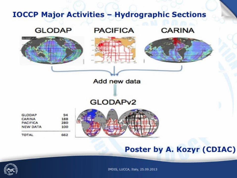
Source: CDIAC
General IOCCP slide
IMDIS, LUCCA, Italy, 25.09.2013

IOCCP Mission and Field of Expertize IOCCP SSG 2011-13Chair
Toste Tanhua (Germany)
Underway pCO2: Ute Schuster (UK)
Surface CO2 Data:
Are Olsen (Norway)
Repeat Hydrography: Bernadette Sloyan (Australia)
Ocean Interior Data: Masao Ishii (Japan)
Time Series Networks: Laura Lorenzoni (US)
Instruments and Sensors: Todd Martz (US)
Data Management: Alex Kozyr (US)
Benjamin Pfeil (Norway)
NutrientsMichio Aoyama (Japan)
Ocean AcidificationRichard Feely (USA)
SOLAS/IMBER: Andrew Lenton (Australia)Niki Gruber (Switzerland)
Project Director: Maciej Telszewski (Poland)
The IOCCP promotes the development of a global network of observations for marine biogeochemistry through technical coordination and communication services, international agreements on standards and methods, and advocacy and links to the global ocean observing system. In each of the fields of our interest (left) IOCCP follows the following scheme:
IMDIS, LUCCA, Italy, 25.09.2013

Source: CDIAC

Source: CDIAC

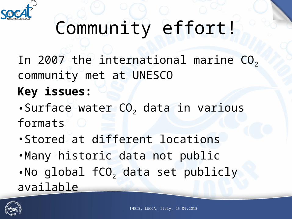
Community effort!
In 2007 the international marine CO2 community met at UNESCOKey issues:
•Surface water CO2 data in various formats
•Stored at different locations•Many historic data not public
•No global fCO2 data set publicly available
IMDIS, LUCCA, Italy, 25.09.2013

Need for two data products:
1) Global surface ocean data set of recalculated fCO2 in a uniform format with 2nd level quality control2) Global gridded product of monthly surface water fCO2 means, with no temporal or spatial interpolation (i.e. bin averages). These data products will be made publicly available.• The methods have to be transparent and fully documented.• Technical articles have to document the methods
IMDIS, LUCCA, Italy, 25.09.2013

And was born

What is theSurface Ocean CO2 Atlas?
• World largest database for QCed surface ocean CO2 data measured on research vessels, voluntary observing ships and other platforms (moored and drifting)
• Not just CO2 but other parameters as well e.g. SST (>13 million records), SSS
IMDIS, LUCCA, Italy, 25.09.2013

1) Global surface ocean data set of recalculated fCO2 in a uniform format with 2nd level quality control2) Global gridded product of monthly surface water fCO2 means, with no temporal or spatial interpolation (i.e. bin averages). These data products are publicly available.• The methods are transparent and fully documented.• Technical articles document the methods
IMDIS, LUCCA, Italy, 25.09.2013
SOCAT: two data products

- File formats and units have been uniformed
- EXPOCODES (ICES/NODC platform code + sailing date)
- Metadata have been collected and organized
- ETOPO2 bottom depths, NCEP/NCAR atm. pressures, WOA salinities, ship speed, GLOBALVIEW CO2 have been added to each datum
- fCO2 has been computed from 13 different reported surface CO2 parameters using a single set of equations
- transparent process
Data adjustments
IMDIS, LUCCA, Italy, 25.09.2013

Primary QCA WOCE flag was assigned to each individual fCO2 datumMatlab scripts for QC, Live Access Server
Secondary QCA ‘cruise’ flag was assigned which provides information on the expected quality of each cruise based of agreed criteria (provided metadata, SoP criterias, acceptable overall data quality, etc.)transparent processRemember: > 2660 cruises with > 10.1 million CO2 data
--> Matlab scripts by A. Olsen & D. Pierrot and ‘SOCAT QC Cookbook’ by A. Olsen & N. Metzl are available Dickson, A.G., Sabine, C.L. and J.R. Chirstian (Eds.) 2007 Guide to best practises for ocean CO2 measurements available
Quality control
IMDIS, LUCCA, Italy, 25.09.2013

Global group: D.Bakker, N. Metzl, S. Hankin, A. Olsen, B. Pfeil, A. Kozyr, D. Pierrot, M. TelszewskiNorth Atlantic: U. Schuster Tropical Atlantic: N. LefevreNorth Pacific: Y. Nojiri Equatorial Pacific: C. CoscaArtic: J. Mathis Indian Ocean: V.V.S.S. SarmaSouthern Ocean: B. Tilbrook and N. MetzlCoastal Ocean: S. Alin, B.Hales, W.-J. CaiAutomation: S. Hankin, S. Jones, K. Smith, A. Kozyr, B. Pfeil, D. Pierrot, K. O’Brien, A. Manke
IMDIS, LUCCA, Italy, 25.09.2013
SOCAT Groups
Community effort: in total more
than 100 people are involved!

History of SOCAT
SOLAS
ORFOIS CARBOOCEAN
SOCOVV
2001
Bakker & Dittert start putting all available pCO2 data together in a uniform formatWork was not finished due to no more funding
Pfeil and Olsen continue
SOLAS/IMBER CARBON group meeting at ICDC73 WGs appointed,WG1: Metzl, “..organiseavailability of present and future data in a single center.”
2005 2007
SOCATReleaseV1
2011 2013
SOCATReleaseV2
SOCATautomation
SST
CO2
IMDIS, LUCCA, Italy, 25.09.2013

Surface Ocean CO2 Atlas
• SOCAT V1.5 was made public in 2011 with 6.3 million fCO2 data on > 1850 cruises covering the years 1968-2007

SOCAT Version 2• Started after the release of SOCAT Version 1• Released in 2013 and consists of 10.1 million
fCO2 data (+60 %) on > 2660 cruises covering the years 1968-2011
IMDIS, LUCCA, Italy, 25.09.2013

Data access
International collaboration between the USA and EuropeData centres involved:
- PANGAEA- CDIAC
Institutes involved:- NOAA/PMEL (LAS)- AWI (ODV)

Academic unit
www. .info

Observational data
SOCAT Products
Gridded data
IMDIS, LUCCA, Italy, 25.09.2013

Cruise Data Viewer
individual cruise overview plot
audit of QC evaluations
property-property viewer
map of user-selectable data
subset
Courtesy of D. Bakker (UEA)

Global gridded fCO2
Monthly fCO2 means, no temporal or spatial interpolation.Open ocean 1° x 1° & coastal waters 1/4° x 1/4°.
Courtesy of D. Bakker (UEA)

Gridded Data Viewer
global cruises/month
N. Atlantic basin-wide average latitude v
time of fCO2
Tropical Pacific annual cycle of fCO2
January average (all years)
¼° x ¼° coastal grid
Courtesy of D. Bakker (UEA)

IMDIS, LUCCA, Italy, 25.09.2013
Data is also available

IMDIS, LUCCA, Italy, 25.09.2013
Use of DOIs within SOCAT
All data is citable using DOIs•individual cruise files•synthesis products (both observational and gridded products)

SOCAT Version 2Transparency
IMDIS, LUCCA, Italy, 25.09.2013

Special use of SOCAT
IMDIS, LUCCA, Italy, 25.09.2013

Towards future releases
Time frame for SOCAT Version 3 December 2013 : Close data submission to CDIACJan-March 2014 : Data submission via automation system (invitation only)October 2014 : Quality control completeJune 2015 : Release (provisional)
Major problem: no central funding! But several funding sources!
Courtesy of D. Bakker (UEA)IMDIS, LUCCA, Italy, 25.09.2013

Academic unit
www. .info
Thank you to all data contributors, the SOCAT team especially regional and global group leader, members, data centers involved and funding
agencies!
IMDIS, LUCCA, Italy, 25.09.2013