Embed Size (px)
Citation preview
University of Nebraska - LincolnDigitalCommons@University of Nebraska - Lincoln
NASA Publications National Aeronautics and Space Administration
2015
Surface evolution of salt-encrusted playas underextreme and continued drynessOctavio ArtiedaUniversidad de Extremadura, 10600 Plasencia, Spain, [email protected]
Alfonso DavilaNASA Ames Research Center, Moffett Field, CA
Jacek WierzchosMuseo Nacional de Ciencias Naturales, MNCN-CSIC, 28006 Madrid, Spain
Peter BuhlerCalifornia Institute of Technology, Pasadena, CA
Rafael Rodríguez-OchoaDept. Medi Ambient i Ciències del Sòl, Universitat de Lleida, 25198 Lleida, Spain
See next page for additional authors
Follow this and additional works at: http://digitalcommons.unl.edu/nasapub
This Article is brought to you for free and open access by the National Aeronautics and Space Administration at DigitalCommons@University ofNebraska - Lincoln. It has been accepted for inclusion in NASA Publications by an authorized administrator of DigitalCommons@University ofNebraska - Lincoln.
Artieda, Octavio; Davila, Alfonso; Wierzchos, Jacek; Buhler, Peter; Rodríguez-Ochoa, Rafael; and Pueyo, Juan, "Surface evolution ofsalt-encrusted playas under extreme and continued dryness" (2015). NASA Publications. 152.http://digitalcommons.unl.edu/nasapub/152

AuthorsOctavio Artieda, Alfonso Davila, Jacek Wierzchos, Peter Buhler, Rafael Rodríguez-Ochoa, and Juan Pueyo
This article is available at DigitalCommons@University of Nebraska - Lincoln: http://digitalcommons.unl.edu/nasapub/152
Surface evolution of salt-encrusted playas underextreme and continued drynessOctavio Artieda,1* Alfonso Davila,2 Jacek Wierzchos,3 Peter Buhler,4 Rafael Rodríguez-Ochoa,5 Juan Pueyo6 and Carmen Ascaso31 Universidad de Extremadura, 10600 Plasencia, Spain2 NASA Ames Research Center, Moffett Field, CA, USA 940353 Museo Nacional de Ciencias Naturales, MNCN-CSIC, 28006 Madrid, Spain4 California Institute of Technology, Pasadena, CA, USA 911255 Dept. Medi Ambient i Ciències del Sòl, Universitat de Lleida, 25198 Lleida, Spain6 Facultat de Geologia, Universitat de Barcelona, 08071 Barcelona, Spain
Received 17 December 2014; Revised 4 June 2015; Accepted 5 June 2015
*Correspondence to: O. Artieda, Universidad de Extremadura, 10600 Plasencia, Spain. E-mail: [email protected]
ABSTRACT: Miocene continental saltpans are scattered in the Central Valley of the Atacama Desert, one of the driest regions onEarth. These evaporitic deposits are hydrologically inactive, and are detached from groundwater brines or aquifers. The surface ofthe saltpans, also known as salars, comprises desiccation polygons, commonly with nodular salt structures along their sides. Themorphology and bulk mineralogy of salt polygons differs between and within salars, and the shape and internal structure of salt nod-ules varies between different polygon types. Based on field observation, and mineralogy and crystallography data, we generated aconceptual model for the genesis and evolution of these surface features, whereby rare rainfall events are responsible for the trans-formation of desiccation salt polygons and the initial formation of salt nodules along polygon borders. In addition, frequent, but lessintense, deliquescence events further drive the evolution of salt nodules, resulting in a characteristic internal structure that includeslaminations, and changes in porosity and crystal morphologies. As a result, and despite the extreme dryness, the surfaces of fossilsalars are dynamic on timescales of several years to decades, in response to daily cycles in atmospheric moisture, and also to rareand meager rainfall events. We propose that fossil salars in the Atacama Desert represent an end stage in the evolution of evaporiticdeposits under extreme and prolonged dryness. Copyright © 2015 John Wiley & Sons, Ltd.
KEYWORDS: salar evolution; Atacama desert; halite; aridity; salt polygons
Introduction
The Atacama Desert extends across 1000 km, from 30°S to 20°S, along the Pacific coast of South America (Figure 1). Geolog-ical evidence and soil mineralogy suggest that extreme aridconditions have persisted in the southern Atacama for >10–15 million years (Stoertz and Ericksen, 1974; Ericksen, 1983;Houston and Hartley, 2003; Dunai et al., 2005; Clarke,2006). The driest parts of the desert are located between ap-proximately 22°S and 26°S, in the broad valley between theCoastal Range and the Cordillera de Domeyko (Figure 1), alsoknown as the Central Valley, with mean annual precipitationbelow 1mmyr�1 in the driest parts (McKay et al., 2003).Extreme and continued dryness has resulted in the formation
and preservation of large continental salt-encrusted playas, or‘salars’ (Stoertz and Ericksen, 1974; Chong, 1988; Ericksenand Salas, 1990; Pueyo et al., 2001). Salars are common geo-morphological features in the Atacama Desert (s.l.), of whichthere are approximately 100 reported occurrences clusteredin three distinct regions: (1) the Coastal Range and Central Val-ley, between 1000 and 2000m elevation; (2) the Andean front,between 2000 and 3000m elevation; and (3) the Andean Alti-plano, between 3000 and 5000m elevation. Salt-encrusted
playas in the Andean front and the Altiplano are hydrologicallyactive, and host scattered small ponds and lakes that repeatedlycycle through a sequence of stages: from desiccation toflooding to evaporative concentration, following the classic cy-cle of ephemeral saltpans (Lowenstein and Hardie, 1985). Thesurface morphology of these active salars is complex and dy-namic, and the surface crusts are shaped into a diversity of mor-phologies, including salt saucers, salt nodules, salt pinnacles,salt solution tubes and salt stalactites (Stoertz and Ericksen,1974). The composition of these crusts is variable, and includescalcium carbonate, nitrates, chloride salts, gypsum, anhydriteand other sulfates (Stoertz and Ericksen, 1974).
On the other hand, most salars along the Coastal Rangeand in the Central Valley are hydrologically inactive, exceptfor rare rainfalls interspersed between long periods of ex-treme dryness, which can last more than a decade (Stoertzand Ericksen, 1974; McKay et al., 2003). These extremelydry conditions have likely persisted since the Miocene(Pueyo et al., 2001), and because these salars are not subjectto seasonal or annual cycles of flooding and evaporation, werefer to them as fossil salars (Chong, 1988) to distinguishthem from the active salars in the Andean front and the Alti-plano. There is an almost complete absence of morphological,
EARTH SURFACE PROCESSES AND LANDFORMSEarth Surf. Process. Landforms (2015)Copyright © 2015 John Wiley & Sons, Ltd.Published online in Wiley Online Library(wileyonlinelibrary.com) DOI: 10.1002/esp.3771
mineralogical and crystallographic data from this unique typeof evaporitic environment.Here we provide detailed field, microscopic and mineralog-
ical observations of surface salt crusts from four fossil salars inthe hyperarid core of the Atacama Desert. We show that thesurface of these salars is dynamic on timescales of several yearsto decades, in response to daily cycles in atmospheric mois-ture, and also to rare and meager rainfall events. Our observa-tions allow us to derive a new end-member model for theevolution of salt-encrusted playas under extreme and continu-ous dryness, whereby salt polygons are gradually transformedinto small nodular structures due to the slow migrations of saltdriven by deliquescence/efflorescence cycles.
Materials and Methods
Field sampling and observations
Field observations and sampling were conducted during sev-eral campaigns in May–June 2009, May 2011, and April2013. We studied the surface morphology of four fossil salars:Yungay, Salar de Navidad, Salar de Llamara, and Salar Grande(Figure 1). The sites were selected to cover a broad region in theCentral Valley, and a gradient of humidity conditions within thehyperarid core of the Atacama, based on previous climate in-vestigations (McKay et al., 2003; Wierzchos et al., 2006,2012; Davila et al., 2008; de los Ríos et al., 2010; Robinsonet al., 2015). We avoided salars with phreatic close to the sur-face, because those could have morphological expressionsnot comparable with the driest salars with deeper or absent
phreatic. At each study site, representative samples were col-lected after extensive field observations and surveys. Collectedsamples represented the most common morphologies found,while rare specimens were documented but not sampled.
Polarizing microscopy
Prior to observation in the polarizing microscope, selectedsamples were prepared following standard protocols devel-oped for fragile and friable materials (Vepraskas and Wilson,2008). Samples were impregnated with polyester resin forthin-section preparation. To prevent dissolution of the saltphases, oil was used as a lubricant during grinding. To avoidgypsum transformations, the temperature never exceeded 40 °Cduring drying of samples for analysis and during thin-sectionpreparation (Artieda, 2013). Petrographic studies of thin sec-tions (30μm thick) were conducted using a Nikon EclipseLV100Pol polarized light microscope equipped with a NikonDS-Fi1 digital camera.
Electron microscopy
The study of thin sections under the polarizing microscope wascomplemented by scanning electron microscope (SEM)equipped with backscattered electron (BSE) detector. Thin sec-tions were carbon-coated and then observed with a Quanta 3DFEG microscope (FEI Company, Hillsboro, USA) equipped withan X-ray microanalytical energy dispersive spectrometer (EDS)system (EDAX, Ametek). SEM examination in BSE detection
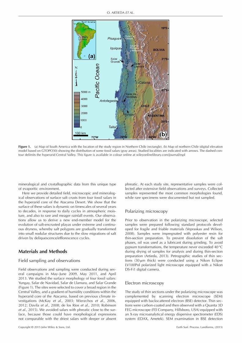
Figure 1. (a) Map of South America with the location of the study region in Northern Chile (rectangle). (b) Map of northern Chile (digital elevationmodel based on GTOPO30) showing the distribution of some fossil salars (gray areas). Studied localities are indicated with arrows. The dashed con-tour delimits the hyperarid Central Valley. This figure is available in colour online at wileyonlinelibrary.com/journal/espl
O. ARTIEDA ET AL.
Copyright © 2015 John Wiley & Sons, Ltd. Earth Surf. Process. Landforms, (2015)
mode and EDS microanalysis of samples were performed si-multaneously. The microscopy and microanalytical operatingconditions were as follows: 0° tilt angle, 35° take-off angle,15 kV acceleration potential, 6 or 25mm working distanceand 1–5 nA specimen current.
X-ray powder diffraction (XRD)
Sample mineralogy was studied by X-ray powder diffraction(XRD), after gently powdering the samples in an agate mortar,and using a Bruker D8 ADVANCE diffractometer withgraphite-monochromated CuK(α) radiation and a linearVANTEC detector. XRD patterns were obtained from randompowder mounts. For qualitative analysis of the crystallinephases present in the samples, the power diffraction file (PDF-
2, 1999) of the International centre for diffraction data (ICDD)was used. A semi-quantitative analysis of these phases was per-formed using the normalized reference intensity ratio (RIR)method (Chung, 1974) and the values for each phase givenby the powder diffraction database (ICDD).
Results
Surface morphology of fossil salars
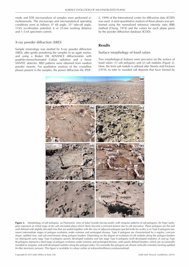
Two morphological features were pervasive on the surface offossil salars: (1) salt polygons; and (2) salt nodules (Figure 2).Here, the term salt nodule is utilized after Stoertz and Ericksen(1974), to refer to rounded salt deposits that have formed by
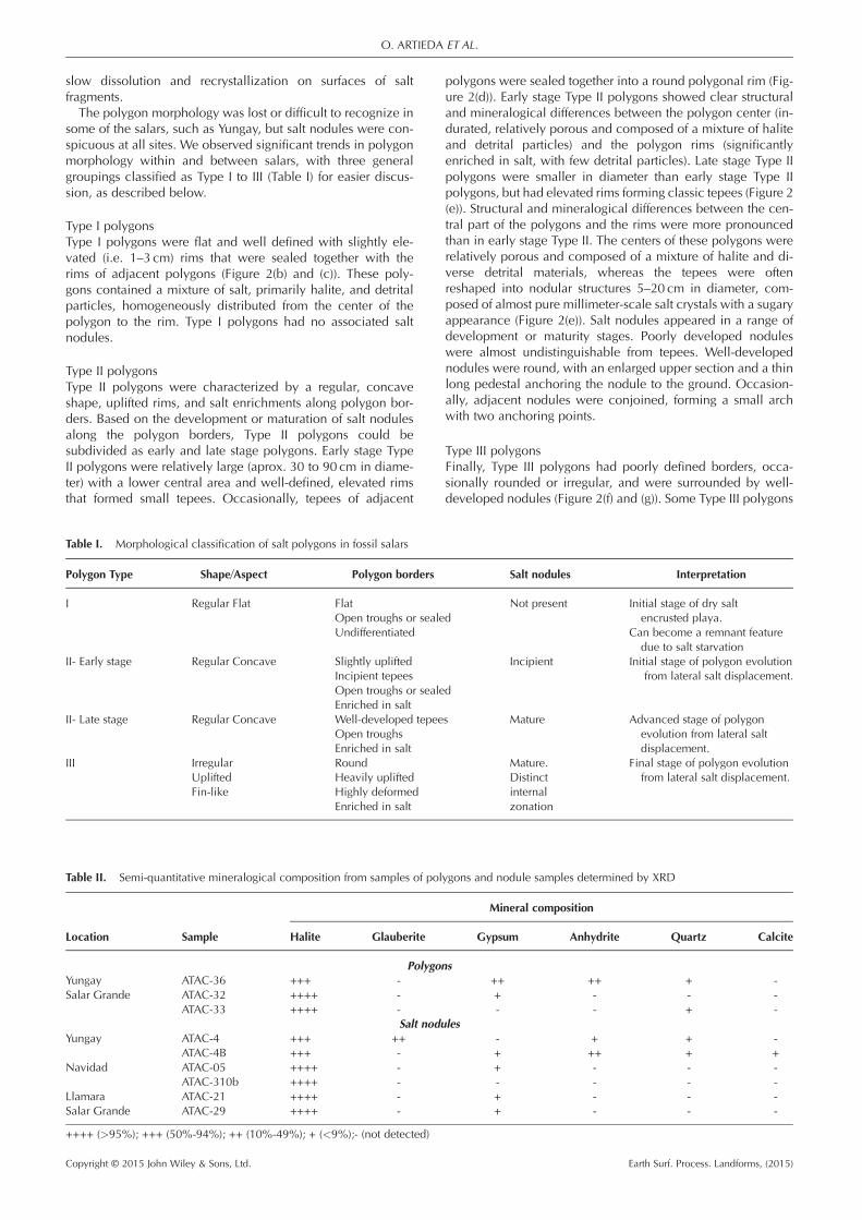
Figure 2. Morphology of salt polygons. (a) Panoramic view of Salar Grande (facing south), with irregular patterns of salt polygons. (b) Type I poly-gons represent an initial stage of dry salt encrusted playa which likely become a remnant feature due to salt starvation. These polygons are flat andwell defined with slightly elevated rims that are sealed together with the rims of adjacent polygons (pocket knife for scale); (c-e) Type II polygons rep-resent intermediate stages of polygon evolution under extreme and prolonged dryness. Type II polygons are characterized by a regular, concaveshape, uplifted rims, and salt enrichments along polygon borders. Depending on the degree of evolution of salt nodules along the polygon borderswe distinguish early stage Type II polygons (poorly developed nodules) and late stage Type II polygons (well developed nodules); (f) and (g) TypeIII polygons represent a final stage of polygon evolution under extreme and prolonged dryness, with poorly defined borders, which are occasionallyrounded or irregular, and well-developed nodules along the polygon sides. Occasionally the polygons are almost vertically oriented, forming upliftedfin-like structures (arrows). This figure is available in colour online at wileyonlinelibrary.com/journal/espl
SURFACE EVOLUTION OF SALT-ENCRUSTED PLAYAS
Copyright © 2015 John Wiley & Sons, Ltd. Earth Surf. Process. Landforms, (2015)
slow dissolution and recrystallization on surfaces of saltfragments.The polygon morphology was lost or difficult to recognize in
some of the salars, such as Yungay, but salt nodules were con-spicuous at all sites. We observed significant trends in polygonmorphology within and between salars, with three generalgroupings classified as Type I to III (Table I) for easier discus-sion, as described below.
Type I polygonsType I polygons were flat and well defined with slightly ele-vated (i.e. 1–3 cm) rims that were sealed together with therims of adjacent polygons (Figure 2(b) and (c)). These poly-gons contained a mixture of salt, primarily halite, and detritalparticles, homogeneously distributed from the center of thepolygon to the rim. Type I polygons had no associated saltnodules.
Type II polygonsType II polygons were characterized by a regular, concaveshape, uplifted rims, and salt enrichments along polygon bor-ders. Based on the development or maturation of salt nodulesalong the polygon borders, Type II polygons could besubdivided as early and late stage polygons. Early stage TypeII polygons were relatively large (aprox. 30 to 90 cm in diame-ter) with a lower central area and well-defined, elevated rimsthat formed small tepees. Occasionally, tepees of adjacent
polygons were sealed together into a round polygonal rim (Fig-ure 2(d)). Early stage Type II polygons showed clear structuraland mineralogical differences between the polygon center (in-durated, relatively porous and composed of a mixture of haliteand detrital particles) and the polygon rims (significantlyenriched in salt, with few detrital particles). Late stage Type IIpolygons were smaller in diameter than early stage Type IIpolygons, but had elevated rims forming classic tepees (Figure 2(e)). Structural and mineralogical differences between the cen-tral part of the polygons and the rims were more pronouncedthan in early stage Type II. The centers of these polygons wererelatively porous and composed of a mixture of halite and di-verse detrital materials, whereas the tepees were oftenreshaped into nodular structures 5–20 cm in diameter, com-posed of almost pure millimeter-scale salt crystals with a sugaryappearance (Figure 2(e)). Salt nodules appeared in a range ofdevelopment or maturity stages. Poorly developed noduleswere almost undistinguishable from tepees. Well-developednodules were round, with an enlarged upper section and a thinlong pedestal anchoring the nodule to the ground. Occasion-ally, adjacent nodules were conjoined, forming a small archwith two anchoring points.
Type III polygonsFinally, Type III polygons had poorly defined borders, occa-sionally rounded or irregular, and were surrounded by well-developed nodules (Figure 2(f) and (g)). Some Type III polygons
Table I. Morphological classification of salt polygons in fossil salars
Polygon Type Shape/Aspect Polygon borders Salt nodules Interpretation
I Regular Flat FlatOpen troughs or sealed
Not present Initial stage of dry saltencrusted playa.
Undifferentiated Can become a remnant featuredue to salt starvation
II- Early stage Regular Concave Slightly uplifted Incipient Initial stage of polygon evolutionfrom lateral salt displacement.Incipient tepees
Open troughs or sealedEnriched in salt
II- Late stage Regular Concave Well-developed tepees Mature Advanced stage of polygonevolution from lateral saltdisplacement.
Open troughsEnriched in salt
III Irregular Round Mature. Final stage of polygon evolutionfrom lateral salt displacement.Uplifted Heavily uplifted Distinct
Fin-like Highly deformed internalEnriched in salt zonation
Table II. Semi-quantitative mineralogical composition from samples of polygons and nodule samples determined by XRD
Location Sample
Mineral composition
Halite Glauberite Gypsum Anhydrite Quartz Calcite
PolygonsYungay ATAC-36 +++ - ++ ++ + -Salar Grande ATAC-32 ++++ - + - - -
ATAC-33 ++++ - - - + -Salt nodules
Yungay ATAC-4 +++ ++ - + + -ATAC-4B +++ - + ++ + +
Navidad ATAC-05 ++++ - + - - -ATAC-310b ++++ - - - - -
Llamara ATAC-21 ++++ - + - - -Salar Grande ATAC-29 ++++ - + - - -
++++ (>95%); +++ (50%-94%); ++ (10%-49%); + (<9%);- (not detected)
O. ARTIEDA ET AL.
Copyright © 2015 John Wiley & Sons, Ltd. Earth Surf. Process. Landforms, (2015)
were almost vertically oriented, forming fin-like structures, andoften it was difficult to differentiate the polygon center from itsborder (arrows in Figure 2(g)).
Mineralogical and crystallographic properties ofsalt polygons
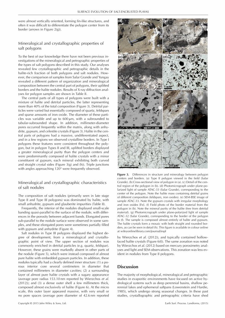
To the best of our knowledge there have not been previous in-vestigations of the mineralogical and petrographic properties ofthe types of salt polygons described in this study. Our analysesrevealed few crystallographic and petrographic details in thehalite-rich fraction of both polygons and salt nodules. How-ever, the comparison of samples from Salar Grande and Yungayrevealed a different pattern of organization and mineralogicalcomposition between the central part of polygons, their upliftedborders and the halite nodules. Results of X-ray diffraction anal-yses for polygon samples are shown in Table II.The central parts of all types of polygons were built with a
mixture of halite and detrital particles, the latter representingmore than 40% of the total composition (Figure 3). Detrital par-ticles were varied but essentially composed of quartz, feldsparsand sparse amounts of iron oxide. The diameter of these parti-cles was variable and up to 600μm, with a subrounded totabular-subrounded shape. In addition, millimeter-diameterpores occurred frequently within the matrix, along with anhy-drite, gypsum, and celestite crystals (Figure 3). Halite in the cen-tral parts of polygons had a massive, undifferentiated aspect,and in a few regions we observed crystalline borders. In Type Ipolygons these features were consistent throughout the poly-gon, but in polygon Types II and III, uplifted borders displayeda greater mineralogical purity than the polygon centers andwere predominantly composed of halite crystals with a minorconstituent of gypsum, each mineral exhibiting both curvedand straight crystal sides (Figure 3(g) and (h)). Triple junctionswith angles approaching 120° were frequently observed.
Mineralogical and crystallographic characteristicsof salt nodules
The composition of salt nodules (primarily seen in late stageType II and Type III polygons) was dominated by halite, withsmall anhydrite, gypsum and glauberite impurities (Table II).Frequently, the interior of the nodules displayed small-scale
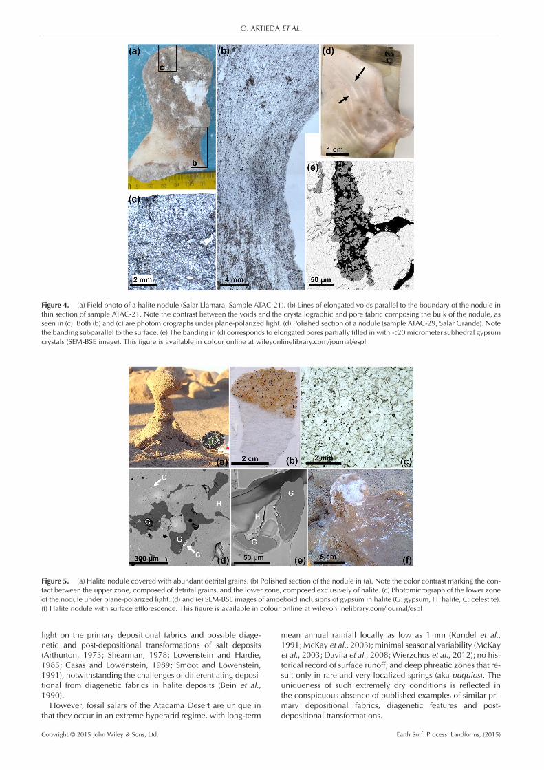
banding quasi-parallel to the surface of the nodule, with differ-ences in the porosity between adjacent bands. Elongated poressub-parallel to the nodule surface were observed in some sam-ples, and these elongated pores were sometimes partially filledwith gypsum and anhydrite (Figure 4).Salt nodules in Type III polygons displayed the highest de-
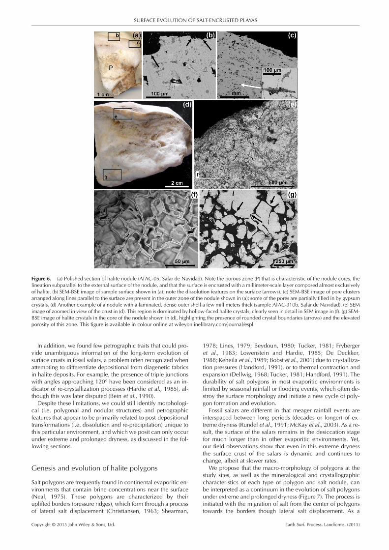
gree of development, from a mineralogical and crystallo-graphic point of view. The upper section of nodules wascommonly enriched in detrital particles (e.g. quartz, feldspar).However, these grains were markedly absent in other parts ofthe nodule (Figure 5), which were instead composed of almostpure halite with embedded gypsum particles. In addition, thesenodules typically had a clearly defined inner structure: (1) a po-rous interior core several centimeters in diameter thatcontained millimeters in diameter cavities; (2) a surroundinglayer of almost pure halite crystals with a sugary appearance(average pore radius 153.10 nm reported by Wierzchos et al.(2012)); and (3) a dense outer shell a few millimeters thick,composed almost exclusively of halite (Figure 6). At the microscale, this outer layer appeared massive, with very small orno pore spaces (average pore diameter of 42.6 nm reported
by Wierzchos et al. (2012)), and typically contained hollow-faced halite crystals (Figure 6(f)). The same zonation was notedby Wierzchos et al. (2012) based on mercury porosimetry anal-yses and light and SEM observations. This zonation was less ev-ident in nodules from Type II polygons.
Discussion
The majority of morphological, mineralogical and petrographicstudies in evaporitic environments have focused on active hy-drological systems such as deep perennial basins, shallow pe-rennial lakes and ephemeral saltpans (Lowenstein and Hardie,1985), which undergo strong seasonal changes. In these paststudies, crystallographic and petrographic criteria have shed
Figure 3. Differences in structure and mineralogy between polygoncenters and borders. (a) Type II polygon viewed in the field (SalarGrande). (b) Cross-sectional view of polygon in (a). (c) Detail of the cen-tral region of the polygon in (b). (d) Photomicrograph under plane-po-larized light of sample ATAC-33 (Salar Grande), corresponding to thecenter of the polygon. Note the halite mass containing detrital grainsof different composition (feldspars, iron oxides). (e) SEM-BSE image ofsample ATAC-33. Note the gypsum crystals with irregular morphologyand iron oxides {Fe}. (f) Field photo of the border material from thepolygon in (b). Note the mineral purity of the halite (free from detritalmaterial). (g) Photomicrograph under plane-polarized light of sampleATAC-32 (Salar Grande), corresponding to the border of the polygonin (f). The sample is composed almost entirely of halite and gypsum.The halite crystals form a mosaic with both straight and rounded bor-ders, as can be seen in detail (h). This figure is available in colour onlineat wileyonlinelibrary.com/journal/espl
SURFACE EVOLUTION OF SALT-ENCRUSTED PLAYAS
Copyright © 2015 John Wiley & Sons, Ltd. Earth Surf. Process. Landforms, (2015)
light on the primary depositional fabrics and possible diage-netic and post-depositional transformations of salt deposits(Arthurton, 1973; Shearman, 1978; Lowenstein and Hardie,1985; Casas and Lowenstein, 1989; Smoot and Lowenstein,1991), notwithstanding the challenges of differentiating deposi-tional from diagenetic fabrics in halite deposits (Bein et al.,1990).However, fossil salars of the Atacama Desert are unique in
that they occur in an extreme hyperarid regime, with long-term
mean annual rainfall locally as low as 1mm (Rundel et al.,1991; McKay et al., 2003); minimal seasonal variability (McKayet al., 2003; Davila et al., 2008; Wierzchos et al., 2012); no his-torical record of surface runoff; and deep phreatic zones that re-sult only in rare and very localized springs (aka puquios). Theuniqueness of such extremely dry conditions is reflected inthe conspicuous absence of published examples of similar pri-mary depositional fabrics, diagenetic features and post-depositional transformations.
Figure 4. (a) Field photo of a halite nodule (Salar Llamara, Sample ATAC-21). (b) Lines of elongated voids parallel to the boundary of the nodule inthin section of sample ATAC-21. Note the contrast between the voids and the crystallographic and pore fabric composing the bulk of the nodule, asseen in (c). Both (b) and (c) are photomicrographs under plane-polarized light. (d) Polished section of a nodule (sample ATAC-29, Salar Grande). Notethe banding subparallel to the surface. (e) The banding in (d) corresponds to elongated pores partially filled in with<20 micrometer subhedral gypsumcrystals (SEM-BSE image). This figure is available in colour online at wileyonlinelibrary.com/journal/espl
Figure 5. (a) Halite nodule covered with abundant detrital grains. (b) Polished section of the nodule in (a). Note the color contrast marking the con-tact between the upper zone, composed of detrital grains, and the lower zone, composed exclusively of halite. (c) Photomicrograph of the lower zoneof the nodule under plane-polarized light. (d) and (e) SEM-BSE images of amoeboid inclusions of gypsum in halite (G: gypsum, H: halite, C: celestite).(f) Halite nodule with surface efflorescence. This figure is available in colour online at wileyonlinelibrary.com/journal/espl
O. ARTIEDA ET AL.
Copyright © 2015 John Wiley & Sons, Ltd. Earth Surf. Process. Landforms, (2015)
In addition, we found few petrographic traits that could pro-vide unambiguous information of the long-term evolution ofsurface crusts in fossil salars, a problem often recognized whenattempting to differentiate depositional from diagenetic fabricsin halite deposits. For example, the presence of triple junctionswith angles approaching 120° have been considered as an in-dicator of re-crystallization processes (Hardie et al., 1985), al-though this was later disputed (Bein et al., 1990).Despite these limitations, we could still identify morphologi-
cal (i.e. polygonal and nodular structures) and petrographicfeatures that appear to be primarily related to post-depositionaltransformations (i.e. dissolution and re-precipitation) unique tothis particular environment, and which we posit can only occurunder extreme and prolonged dryness, as discussed in the fol-lowing sections.
Genesis and evolution of halite polygons
Salt polygons are frequently found in continental evaporitic en-vironments that contain brine concentrations near the surface(Neal, 1975). These polygons are characterized by theiruplifted borders (pressure ridges), which form through a processof lateral salt displacement (Christiansen, 1963; Shearman,
1978; Lines, 1979; Beydoun, 1980; Tucker, 1981; Frybergeret al., 1983; Lowenstein and Hardie, 1985; De Deckker,1988; Keheila et al., 1989; Bobst et al., 2001) due to crystalliza-tion pressures (Handford, 1991), or to thermal contraction andexpansion (Dellwig, 1968; Tucker, 1981; Handford, 1991). Thedurability of salt polygons in most evaporitic environments islimited by seasonal rainfall or flooding events, which often de-stroy the surface morphology and initiate a new cycle of poly-gon formation and evolution.
Fossil salars are different in that meager rainfall events areinterspaced between long periods (decades or longer) of ex-treme dryness (Rundel et al., 1991; McKay et al., 2003). As a re-sult, the surface of the salars remains in the desiccation stagefor much longer than in other evaporitic environments. Yet,our field observations show that even in this extreme drynessthe surface crust of the salars is dynamic and continues tochange, albeit at slower rates.
We propose that the macro-morphology of polygons at thestudy sites, as well as the mineralogical and crystallographiccharacteristics of each type of polygon and salt nodule, canbe interpreted as a continuum in the evolution of salt polygonsunder extreme and prolonged dryness (Figure 7). The process isinitiated with the migration of salt from the center of polygonstowards the borders though lateral salt displacement. As a
Figure 6. (a) Polished section of halite nodule (ATAC-05, Salar de Navidad). Note the porous zone (P) that is characteristic of the nodule cores, thelineation subparallel to the external surface of the nodule, and that the surface is encrusted with a millimeter-scale layer composed almost exclusivelyof halite. (b) SEM-BSE image of sample surface shown in (a); note the dissolution features on the surface (arrows). (c) SEM-BSE image of pore clustersarranged along lines parallel to the surface are present in the outer zone of the nodule shown in (a); some of the pores are partially filled in by gypsumcrystals. (d) Another example of a nodule with a laminated, dense outer shell a few millimeters thick (sample ATAC-310b, Salar de Navidad). (e) SEMimage of zoomed in view of the crust in (d). This region is dominated by hollow-faced halite crystals, clearly seen in detail in SEM image in (f). (g) SEM-BSE image of halite crystals in the core of the nodule shown in (d), highlighting the presence of rounded crystal boundaries (arrows) and the elevatedporosity of this zone. This figure is available in colour online at wileyonlinelibrary.com/journal/espl
SURFACE EVOLUTION OF SALT-ENCRUSTED PLAYAS
Copyright © 2015 John Wiley & Sons, Ltd. Earth Surf. Process. Landforms, (2015)
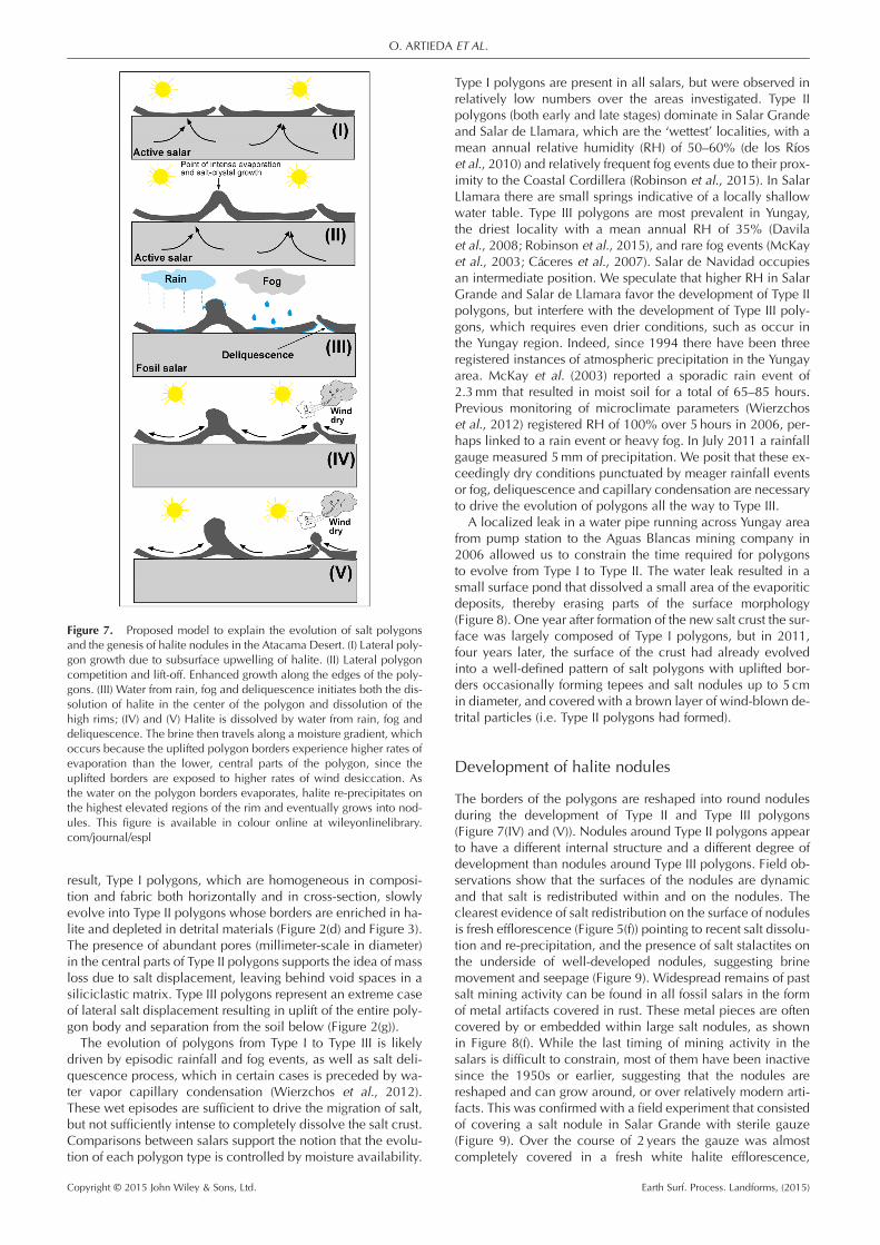
result, Type I polygons, which are homogeneous in composi-tion and fabric both horizontally and in cross-section, slowlyevolve into Type II polygons whose borders are enriched in ha-lite and depleted in detrital materials (Figure 2(d) and Figure 3).The presence of abundant pores (millimeter-scale in diameter)in the central parts of Type II polygons supports the idea of massloss due to salt displacement, leaving behind void spaces in asiliciclastic matrix. Type III polygons represent an extreme caseof lateral salt displacement resulting in uplift of the entire poly-gon body and separation from the soil below (Figure 2(g)).The evolution of polygons from Type I to Type III is likely
driven by episodic rainfall and fog events, as well as salt deli-quescence process, which in certain cases is preceded by wa-ter vapor capillary condensation (Wierzchos et al., 2012).These wet episodes are sufficient to drive the migration of salt,but not sufficiently intense to completely dissolve the salt crust.Comparisons between salars support the notion that the evolu-tion of each polygon type is controlled by moisture availability.
Type I polygons are present in all salars, but were observed inrelatively low numbers over the areas investigated. Type IIpolygons (both early and late stages) dominate in Salar Grandeand Salar de Llamara, which are the ‘wettest’ localities, with amean annual relative humidity (RH) of 50–60% (de los Ríoset al., 2010) and relatively frequent fog events due to their prox-imity to the Coastal Cordillera (Robinson et al., 2015). In SalarLlamara there are small springs indicative of a locally shallowwater table. Type III polygons are most prevalent in Yungay,the driest locality with a mean annual RH of 35% (Davilaet al., 2008; Robinson et al., 2015), and rare fog events (McKayet al., 2003; Cáceres et al., 2007). Salar de Navidad occupiesan intermediate position. We speculate that higher RH in SalarGrande and Salar de Llamara favor the development of Type IIpolygons, but interfere with the development of Type III poly-gons, which requires even drier conditions, such as occur inthe Yungay region. Indeed, since 1994 there have been threeregistered instances of atmospheric precipitation in the Yungayarea. McKay et al. (2003) reported a sporadic rain event of2.3mm that resulted in moist soil for a total of 65–85 hours.Previous monitoring of microclimate parameters (Wierzchoset al., 2012) registered RH of 100% over 5 hours in 2006, per-haps linked to a rain event or heavy fog. In July 2011 a rainfallgauge measured 5mm of precipitation. We posit that these ex-ceedingly dry conditions punctuated by meager rainfall eventsor fog, deliquescence and capillary condensation are necessaryto drive the evolution of polygons all the way to Type III.
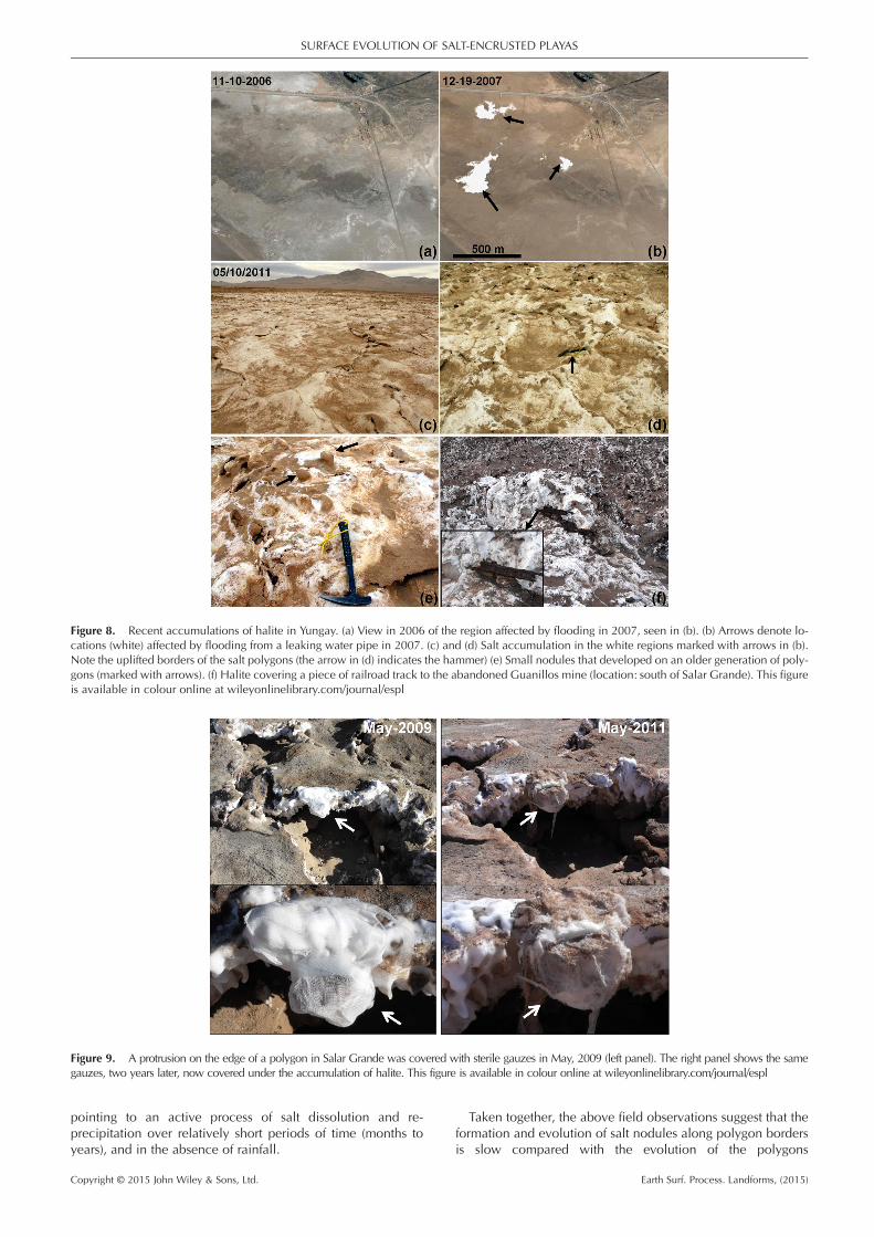
A localized leak in a water pipe running across Yungay areafrom pump station to the Aguas Blancas mining company in2006 allowed us to constrain the time required for polygonsto evolve from Type I to Type II. The water leak resulted in asmall surface pond that dissolved a small area of the evaporiticdeposits, thereby erasing parts of the surface morphology(Figure 8). One year after formation of the new salt crust the sur-face was largely composed of Type I polygons, but in 2011,four years later, the surface of the crust had already evolvedinto a well-defined pattern of salt polygons with uplifted bor-ders occasionally forming tepees and salt nodules up to 5 cmin diameter, and covered with a brown layer of wind-blown de-trital particles (i.e. Type II polygons had formed).
Development of halite nodules
The borders of the polygons are reshaped into round nodulesduring the development of Type II and Type III polygons(Figure 7(IV) and (V)). Nodules around Type II polygons appearto have a different internal structure and a different degree ofdevelopment than nodules around Type III polygons. Field ob-servations show that the surfaces of the nodules are dynamicand that salt is redistributed within and on the nodules. Theclearest evidence of salt redistribution on the surface of nodulesis fresh efflorescence (Figure 5(f)) pointing to recent salt dissolu-tion and re-precipitation, and the presence of salt stalactites onthe underside of well-developed nodules, suggesting brinemovement and seepage (Figure 9). Widespread remains of pastsalt mining activity can be found in all fossil salars in the formof metal artifacts covered in rust. These metal pieces are oftencovered by or embedded within large salt nodules, as shownin Figure 8(f). While the last timing of mining activity in thesalars is difficult to constrain, most of them have been inactivesince the 1950s or earlier, suggesting that the nodules arereshaped and can grow around, or over relatively modern arti-facts. This was confirmed with a field experiment that consistedof covering a salt nodule in Salar Grande with sterile gauze(Figure 9). Over the course of 2 years the gauze was almostcompletely covered in a fresh white halite efflorescence,
Figure 7. Proposed model to explain the evolution of salt polygonsand the genesis of halite nodules in the Atacama Desert. (I) Lateral poly-gon growth due to subsurface upwelling of halite. (II) Lateral polygoncompetition and lift-off. Enhanced growth along the edges of the poly-gons. (III) Water from rain, fog and deliquescence initiates both the dis-solution of halite in the center of the polygon and dissolution of thehigh rims; (IV) and (V) Halite is dissolved by water from rain, fog anddeliquescence. The brine then travels along a moisture gradient, whichoccurs because the uplifted polygon borders experience higher rates ofevaporation than the lower, central parts of the polygon, since theuplifted borders are exposed to higher rates of wind desiccation. Asthe water on the polygon borders evaporates, halite re-precipitates onthe highest elevated regions of the rim and eventually grows into nod-ules. This figure is available in colour online at wileyonlinelibrary.com/journal/espl
O. ARTIEDA ET AL.
Copyright © 2015 John Wiley & Sons, Ltd. Earth Surf. Process. Landforms, (2015)
pointing to an active process of salt dissolution and re-precipitation over relatively short periods of time (months toyears), and in the absence of rainfall.
Taken together, the above field observations suggest that theformation and evolution of salt nodules along polygon bordersis slow compared with the evolution of the polygons
Figure 8. Recent accumulations of halite in Yungay. (a) View in 2006 of the region affected by flooding in 2007, seen in (b). (b) Arrows denote lo-cations (white) affected by flooding from a leaking water pipe in 2007. (c) and (d) Salt accumulation in the white regions marked with arrows in (b).Note the uplifted borders of the salt polygons (the arrow in (d) indicates the hammer) (e) Small nodules that developed on an older generation of poly-gons (marked with arrows). (f) Halite covering a piece of railroad track to the abandoned Guanillos mine (location: south of Salar Grande). This figureis available in colour online at wileyonlinelibrary.com/journal/espl
Figure 9. A protrusion on the edge of a polygon in Salar Grande was covered with sterile gauzes in May, 2009 (left panel). The right panel shows the samegauzes, two years later, now covered under the accumulation of halite. This figure is available in colour online at wileyonlinelibrary.com/journal/espl
SURFACE EVOLUTION OF SALT-ENCRUSTED PLAYAS
Copyright © 2015 John Wiley & Sons, Ltd. Earth Surf. Process. Landforms, (2015)
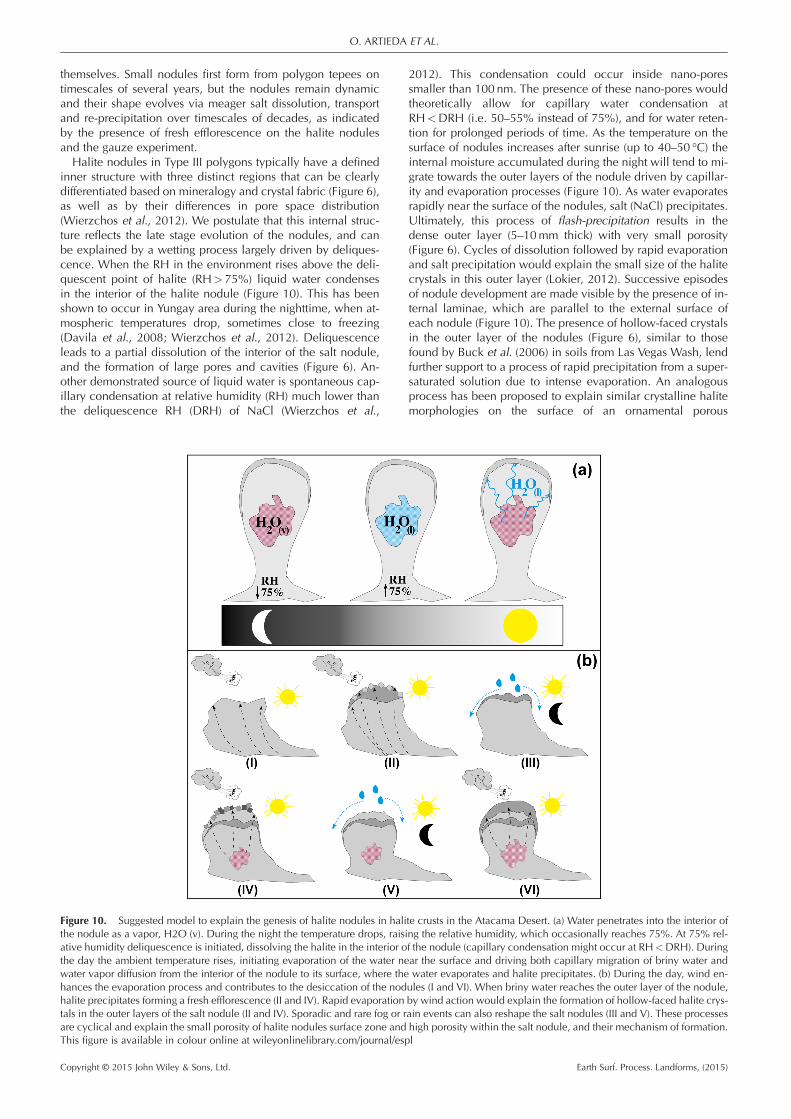
themselves. Small nodules first form from polygon tepees ontimescales of several years, but the nodules remain dynamicand their shape evolves via meager salt dissolution, transportand re-precipitation over timescales of decades, as indicatedby the presence of fresh efflorescence on the halite nodulesand the gauze experiment.Halite nodules in Type III polygons typically have a defined
inner structure with three distinct regions that can be clearlydifferentiated based on mineralogy and crystal fabric (Figure 6),as well as by their differences in pore space distribution(Wierzchos et al., 2012). We postulate that this internal struc-ture reflects the late stage evolution of the nodules, and canbe explained by a wetting process largely driven by deliques-cence. When the RH in the environment rises above the deli-quescent point of halite (RH> 75%) liquid water condensesin the interior of the halite nodule (Figure 10). This has beenshown to occur in Yungay area during the nighttime, when at-mospheric temperatures drop, sometimes close to freezing(Davila et al., 2008; Wierzchos et al., 2012). Deliquescenceleads to a partial dissolution of the interior of the salt nodule,and the formation of large pores and cavities (Figure 6). An-other demonstrated source of liquid water is spontaneous cap-illary condensation at relative humidity (RH) much lower thanthe deliquescence RH (DRH) of NaCl (Wierzchos et al.,
2012). This condensation could occur inside nano-poressmaller than 100 nm. The presence of these nano-pores wouldtheoretically allow for capillary water condensation atRH<DRH (i.e. 50–55% instead of 75%), and for water reten-tion for prolonged periods of time. As the temperature on thesurface of nodules increases after sunrise (up to 40–50 °C) theinternal moisture accumulated during the night will tend to mi-grate towards the outer layers of the nodule driven by capillar-ity and evaporation processes (Figure 10). As water evaporatesrapidly near the surface of the nodules, salt (NaCl) precipitates.Ultimately, this process of flash-precipitation results in thedense outer layer (5–10mm thick) with very small porosity(Figure 6). Cycles of dissolution followed by rapid evaporationand salt precipitation would explain the small size of the halitecrystals in this outer layer (Lokier, 2012). Successive episodesof nodule development are made visible by the presence of in-ternal laminae, which are parallel to the external surface ofeach nodule (Figure 10). The presence of hollow-faced crystalsin the outer layer of the nodules (Figure 6), similar to thosefound by Buck et al. (2006) in soils from Las Vegas Wash, lendfurther support to a process of rapid precipitation from a super-saturated solution due to intense evaporation. An analogousprocess has been proposed to explain similar crystalline halitemorphologies on the surface of an ornamental porous
Figure 10. Suggested model to explain the genesis of halite nodules in halite crusts in the Atacama Desert. (a) Water penetrates into the interior ofthe nodule as a vapor, H2O (v). During the night the temperature drops, raising the relative humidity, which occasionally reaches 75%. At 75% rel-ative humidity deliquescence is initiated, dissolving the halite in the interior of the nodule (capillary condensation might occur at RH<DRH). Duringthe day the ambient temperature rises, initiating evaporation of the water near the surface and driving both capillary migration of briny water andwater vapor diffusion from the interior of the nodule to its surface, where the water evaporates and halite precipitates. (b) During the day, wind en-hances the evaporation process and contributes to the desiccation of the nodules (I and VI). When briny water reaches the outer layer of the nodule,halite precipitates forming a fresh efflorescence (II and IV). Rapid evaporation by wind action would explain the formation of hollow-faced halite crys-tals in the outer layers of the salt nodule (II and IV). Sporadic and rare fog or rain events can also reshape the salt nodules (III and V). These processesare cyclical and explain the small porosity of halite nodules surface zone and high porosity within the salt nodule, and their mechanism of formation.This figure is available in colour online at wileyonlinelibrary.com/journal/espl
O. ARTIEDA ET AL.
Copyright © 2015 John Wiley & Sons, Ltd. Earth Surf. Process. Landforms, (2015)
limestone after evaporation of a brine solution (Rodriguez-Navarro et al., 2002). Other authors (Joeckel and Clement,1999) found similar morphologies in surface salt crusts, whichwere interpreted as partially dissolved halite crystals. We inter-pret the morphology of the hollow-faced halite crystals as anindication of salt precipitation from saturated brine, resultingin skeletal crystals with cubic and prismatic shapes. The roundaspect of the halite crystals would then be a result of subse-quent partial dissolution due to the presence of water betweencrystals. Finally, Hovorka et al. (2007) proposed that the surfaceof saltpans is subject to hygroscopic alteration that reducescrystal size and increases cementation.Wind action might contribute to the evolution of salt nodules
in two different ways: (1) by accelerating evaporation on thesurface of the nodule and enhancing the movement of waterfrom the interior of the nodule towards the surface; and (2) byabrading and eroding the salt nodules with entrained sand par-ticles. Fin-like structures in Type III polygons (Figure 2(g)) arelikely examples of nodule (and polygon) erosion by windaction.Rare rainfall and fog events could be responsible for some of
the dissolution features observed on the surface of the nodules(Figure 6(b)), as well as the pattern of large pores sub-parallel totheir surface (Figure 4). However, rainfall and fog events are soinfrequent and sparse in the Yungay region that they are un-likely to play a significant role in the long-term evolution ofthe nodules. The presence of the nodules themselves speaksagainst substantial surface ponding or flooding, which woulddissolve and destroy the nodules, and argues instead for a slowevolution driven by moist events that are able to mobilize saltbut at the same time preserve the structures, such as deliques-cence and capillary condensation of water vapor.The presence of active colonies of endolithic microorgan-
isms inside the halite nodules (Wierzchos et al., 2006, 2012;Davila et al., 2008, 2013; de los Ríos et al., 2010; Robinsonet al., 2015), with estimated rates of carbon cycling of decadesto centuries (Ziolkowski et al., 2013) lends further support tothe long-lived nature and slow evolution of these uniquestructures.
Conclusions
Surface morphologies in hydrologically inactive fossil salarsdetached from groundwater brines are interpreted here as anend stage in the evolution of evaporitic deposits under extremeand prolonged dryness. The surface of these fossil salars is char-acterized by the presence of salt polygons with nodular struc-tures along polygon borders.The morphology and bulk mineralogy of salt polygons dif-
fers between and within salars, and the shape and internalstructure of salt nodules varies between different polygontypes. We propose that rare rainfall events are responsiblefor the differential displacement of salt from the center tothe border of desiccation polygons, and the partial dissolu-tion of salt nodules along polygon borders. On the otherhand, frequent, but less intense, deliquescence and capillarycondensation results in brine water condensing in the interiorof nodules, leading to partial dissolution of the salt fabric andthe formation of large pore spaces. Deliquescence brine mi-grates outward from the center of the nodules, following ther-mal and humidity gradients. Rapid evaporation of the brinefluids near the surface results in the observed layered struc-ture, fine porosity and characteristic crystal morphologies.Hence, despite extreme dryness, the surfaces of fossil salarsare dynamic on timescales of several years to decades, in re-sponse to daily cycles in atmospheric moisture, and also to
rare and meager rainfall events. Wind likely plays animportant role in the formation and evolution of the nodules,both as an erosive agent and by increasing the evaporationrates of deliquescence brines near the surface of the nodules.However, its relative importance on the evolution of thenodules is difficult to evaluate. We propose that fossil salarsin the Atacama Desert represent an end stage in the evolu-tion of evaporitic deposits under extreme and prolongeddryness.
Acknowledgements—Technical support was provided by SAIUEX(Universidad de Extremadura) for the XRD analyses and scanning elec-tron microscopy study. This work was funded by grant CGL2010-16004and CGL2013-42509 from the Spanish Ministry of Science and Innova-tion. A.F.D., O.A. and J.W. were supported by Grant NNX12AD61G ofthe NASA Astrobiology program. P.B. was supported by the Thomas J.Watson Foundation. The authors also thank Charlotte Schreiber andan anonymous referee for their critical and constructive reviews.
ReferencesArthurton RS. 1973. Experimentally produced halite compared withTriassic layered halite-rock from Cheshire, England. Sedimentology20: 145–160.
Artieda O. 2013. Morphology and micro-fabrics of weathering featureson gyprock exposures in a semiarid environment (Ebro Tertiary Basin,NE Spain). Geomorphology 196: 198–210.
Bein A, Hovorka SD, Fisher RS, Roedder E. 1990. Fluid inclusions inbedded Permian halite, Palo Duro Basin, Texas: evidence for modifi-cation of seawater in evaporite brine-pools and subsequent earlydiagenesis. Journal of Sedimentary Petrology 61(1): 1–14.
Beydoun ZR. 1980. Some holocene geomorphological and sedimento-logical observations from Oman and their palaeogeological implica-tions. Journal of Petroleum Geology 2(4): 427–437.
Bobst AL, Lowenstein TK, Jordan TE, Godfrey LV, Ku T-L, Luo S. 2001. A106 ka paleoclimate record from drill core of the Salar de Atacama,northern Chile. Palaeogeography Palaeoclimatology Palaeoecology173: 21–42.
Buck BJ, Wolff K, Merkler DJ, McMillan NJ. 2006. Salt mineralogy ofLas Vegas Wash, Nevada: morphology and subsurface evaporation.Soil Science Society of America Journal 70: 1639–1651.
Cáceres L, Gómez-Silva B, Garró X, Rodríguez V, Monardes V, McKayCP. 2007. Relative humidity patterns and fog water precipitation inthe Atacama Desert and biological implications. Journal of Geophys-ical Research 112: G4S14. DOI: 10.1029/2006JG000344
Casas E, Lowenstein TK. 1989. Diagenesis of saline pan halite: compar-ison of petrographic features of Modem, Quaternary and Permianhalites. Journal of Sedimentary Petrology 59(5): 724–739.
Chong G. 1988. The Cenozoic saline deposits of the Chilean Andes be-tween 18° and 27° South. In The southern Central Andes, Bahlburg H,Breitkreuz C, Giese P (eds). Springer-Verlag: Heidelberg; 135–151.
Christiansen FW. 1963. Polygonal fracture and fold systems in the saltcrust, Great Salt Lake desert, Utah. Science 139: 607–609.
Chung FH. 1974. Quantitative interpretation of X-ray-diffraction pat-terns of mixtures. II. Adiabatic principle of X-ray-diffraction analysisof mixtures. Journal of Applied Crystallography 7: 526–531.
Clarke J. 2006. Antiquity of aridity in the Chilean Atacama Desert.Geo-morphology 73(1–2): 101–114.
Davila AF, Gómez-Silva B, de los Ríos A, Ascaso C, Olivares H, McKayCP, Wierzchos J. 2008. Facilitation of endolithic microbial survival inthe hyperarid core of the Atacama Desert by mineral deliquescence.Journal of Geophysical Research 113: G01028. DOI: 10.1029/2007JG000561
Davila AF, Hawes I, Ascaso C, Wierzchos J. 2013. Salt deliquescencedrives photosynthesis in the hyperarid Atacama Desert. Environmen-tal Microbiology Reports 5: 583–587. DOI: 10.1111/1758-2229.12050
De Deckker P. 1988. Biological and sedimentary facies of Australiansalt lakes. Palaeogeography Palaeoclimatology Palaeoecology 62:237–270.
SURFACE EVOLUTION OF SALT-ENCRUSTED PLAYAS
Copyright © 2015 John Wiley & Sons, Ltd. Earth Surf. Process. Landforms, (2015)
Dellwig LF. 1968. Significant features of deposition in the HutchinsonSalt, Kansas, and their interpretation. Geological Society of America,Special Paper 88: 421–427.
de los Ríos A, Valea S, Ascaso C, Davila A, Kastovsky J, McKay CP,Gómez-Silva B, Wierzchos J. 2010. Comparative analysis of themicrobial communities inhabiting halite evaporites of the AtacamaDesert. International Microbiology 13: 79–89. DOI: 10.2436/20.1501.01.113
Dunai TJ, González-López GA, Juez-Larré J. 2005. Oligocene-mioceneage of aridity in the Atacama Desert revealed by exposure dating oferosion-sensitive landforms. Geology 33: 321–324.
Ericksen GE. 1983. The Chilean nitrate deposits. American Scientist71(4): 366–374.
Ericksen GE, Salas R. 1990. Geology and resources of salars in theCentral Andes. In Geology of the Andes and Its Relation to Hydrocar-bon and Mineral Resources, Ericksen GE, Cañas MT, Reinemund JA(eds). Earth Science Series, 11. Circum-Pacific Council for Energyand Mineral Resources: Houston, Texas; 165–172.
Fryberger SG, Al-Sari AM, Clisham TJ. 1983. Eolian dune, interdune,sand sheet, and siliciclastic sabkha sediments of an offshore area,Dhahran Area, Saudi Arabia. American Association of PetroleumGeologists Bulletin 67: 280–312.
Handford CR. 1991. Marginal Marine Halite: Sabkhas and Salinas. InEvaporites, Petroleum and Mineral Resources. Developments inSedimentology, Elsevier: Amsterdam; 1–66.
Hardie LA, Lowenstein TK, Spencer RJ. 1985. The problem ofdistinguishing between primary and secondary features in evaporites.In Sixth Inter Symposium on Salt, Schreiber BC, Harner HL (eds). TheSalt Institute: Alexandria, Virginia; 11–39.
Houston J, Hartley AJ. 2003. The central Andean west-sloperainshadow and its potential contribution to the origin of hyper-aridity in the Atacama Desert. International Journal of Climatology23: 1453–1464.
Hovorka SD, Holt RM, Powers DW. 2007. Depth indicators in PermianBasin evaporites. In Evaporites Through Space and Time, SchreiberBC, Lugli S, Babel M (eds). Geological Society: London, SpecialPublications; 285; 335–364.
Joeckel RM, Clement BA. 1999. Surface features of the Salt Basin ofLancaster County, Nebraska. Catena 34: 243–275.
Keheila E, Khalifa H, El-Haddad A. 1989. Holocene carbonatefacies model, Ras Shukhier hypersaline pool and its surroundingsabkha, west Gulf of Suez, Egypt. Sedimentary Geology 63:155–169.
Lines GC. 1979. Hydrology and Surface Morphology of the BonnevilleSalt Flats and Pilot Valley, Utah. US Geological Survey, Washington,DC, USA. Water-Supply Paper 2057.
Lokier SW. 2012. Development and evolution of subaerial halite crustmorphologies in a coastal sabkha setting. Journal of Arid Environ-ments 79: 32–47.
Lowenstein TK, Hardie LA. 1985. Criteria for the recognition of salt-panevaporites. Sedimentology 32: 627–644.
McKay CP, Friedmann EI, Gómez-Silva B, Cáceres-Villanueva L,Andersen DT, Landheim R. 2003. Temperature and moisture condi-tions in the extreme arid regions of the Atacama Desert: four yearsof observations including the El Niño of 1997–1998. Astrobiology 3:393–406.
Neal JT. 1975. Playas and Dried Lakes: Occurrence and Develop-ment. Dowden, Hutchinson and Ross: Stroudsburg, PA.
Pueyo JJ, Chong G, Jensen A. 2001. Neogene evaporites in desert vol-canic environments: Atacama Desert, northern Chile. Sedimentology48: 1411–1431.
Robinson CK, Wierzchos J, Black C, Crits-Christoph A, Ma B, Ravel J,Ascaso C, Artieda O, Valea S, Roldan M, Gomez-Silva B, DiruggieroJ. 2015. Microbial diversity and the presence of algae in halite endo-lithic communities are correlated to atmospheric moisture in thehyper-arid zone of the Atacama Desert. Environmental Microbiology17: 299–315. DOI: 10.1111/1462-2920.12364
Rodriguez-Navarro C, Linares-Fernandez L, Doehne E, Sebastian E.2002. Effects of ferrocyanide ions on NaCl crystallization in porousstone. Journal of Crystal Growth 243: 503–516.
Rundel PW, Dillon MO, Palma B, Mooney HA, Gulmon SL, Ehleringer,JR. 1991. The phytogeography and ecology of the coastal Atacamaand Peruvian deserts. Aliso 13: 1–49
Shearman DJ. 1978. Evaporites of coastal sabkhas. In Marine Evapo-rites, Dean WE, Schreiber BC (eds). SEPM Short Course No. 4.Society for Sedimentary Geology; 6–42.
Smoot JP, Lowenstein TK. 1991. Depositional environments of non-marine evaporites. In Evaporites Petroleum and, Mineral Resources,Melvin JL (ed). Developments in Sedimentology 50. Elsevier SciencePublishers BV: Amsterdam; 189–347.
Stoertz GE, Ericksen GE. 1974. Geology of Salars in Northern Chile.US Geological Survey, Professional Paper, No. 811.
Tucker RM. 1981. Giant polygons in the Triassic salt of Cheshire,England: a thermal contraction model for their origin. Journal ofSedimentary Petrology 51: 779–786.
Vepraskas MJ, Wilson MA. 2008. Soil micromorphology: concepts,techniques, and applications. In Methods of Soils Analysis, Part 5 –Mineralogical Methods, Ulrey AL, Drees LR (eds). Soil ScienceSociety of America: Madison WI; 191–225.
Wierzchos J, Ascaso C, McKay CP. 2006. Endolithic cyanobacteria inhalite rocks from the hyperarid core of the Atacama Desert. Astrobi-ology 6(3): 415–422.
Wierzchos J, Davila AF, Sánchez-Almazo IM, Hajnos M, Swieboda R,Ascaso C. 2012. Novel water source for endolithic life in the hyper-arid core of the Atacama Desert. Biogeosciences 9: 2275–2286.
Ziolkowski LA, Wierzchos J, Davila AF, Slater, GF. 2013. Radiocarbonevidence of active endolithic microbial communities in the hyperaridcore of the Atacama Desert. Astrobiology 13(7): 607–616.
O. ARTIEDA ET AL.
Copyright © 2015 John Wiley & Sons, Ltd. Earth Surf. Process. Landforms, (2015)