Embed Size (px)
Citation preview

Surface Dispersion by Mesoscale Eddies Using Altimeter Data
Long Zhou
3nd Student Seminar, 11/06/2006

Outline
• Objectives and Applications
• Dataset
• Method
• One example of model output
• Results
• Summary and future work

Objectives • Examine absolute dispersion at ocean
surface
• Find out the relative diffusivities
at different separation distances
Applications • Improve parameterization of eddy diffusivity in climate numerical modeling
• Pollutant fate (e.g. oil spills)
• Larval transport

Dataset: Satellite altimetry
JETEG along-track sea level anomalies (SLA) for three years
02/25/2003 to 02/25/2006
Jason1 Envisat Topex2 ERS GFO
Note: GFO=Geosat Follow-on

Method
a. Objective mapping of JETEG with a space-time correlation
model => daily SLA maps (02/25/2003 to 02/25/2006).
b. Derive stirring velocities Vs from SLA assuming geostrophic
balance holds.
c. Random walk numerical model with a daily time step and
1/6 degree of spatial resolution.
, where randnRDVVm VmVsVtotal

Longitude
latitu
de
mean eddy KE (cm/s)2 over 3 years(02/25/2003 to 02/25/2006)
38oW 34oW 30oW 26oW 22oW 18oW
2oN
4oN
6oN
8oN
10oN
12oN
3565.9084 3565.9084 2077.8211 1848.8846
589.7338
131.8608
200 400 600 800 1000 1200 1400 1600 1800
One example of model output: where to deploy
KE: kinetic energy

One example of model output
03/02/2003-07/30/2003

0 10 20 30 40 50 60 70 80 900
1
2
3
4
5
6
7
8x 10
4
days
zonal
abs.
dis
p.(km
2 )
zonal absolute dispersion changing with random velocity
0.10.20.30.40.50.60.70.80.9 11.5 22.5 3
0.5-0.9
3
0.1
Results
• Find RDV to be 0.75 to reasonably represent submesoscale process.
N
iitia xx
NtxD
1
20,, )(
1),(
1
1 1
2,, )(
)!1(
1),(
N
i
N
ijtjtir xx
NtxD
0 10 20 30 40 50 60 70 80 900
5
10
15x 10
4
days
zonal
rel
.dis
p.(km
2 )
zonal relative dispersion changing with random velocity
0.10.20.30.40.50.60.70.80.9 11.5 22.5 3
3
0.5-0.9
0.1

• Absolute dispersion: zonal > meridional
a b
c d

• At scale of less than 200 km, relative diffusivity grow quadratically.
• Later can be scaled as distance to the 2/3 power.
0 200 400 600 800 1000 1200 1400-0.5
0
0.5
1
1.5
2
2.5
3
3.5
4
4.5x 10
4
distance(km)
diffu
sivi
ties
(m2 /s
ec)
relative diffusivities vs. mean square separation
mu vs. msd
msd2/3
msd2

Summary
• RDV=0.75 to reasonably represent submesoscale process.
• Absolute dispersion: zonal > meridional.
• Relative diffusivities can be scaled with separation distance.
Future Work
• Statistical analysis of ensembles
• Add larva growth rate
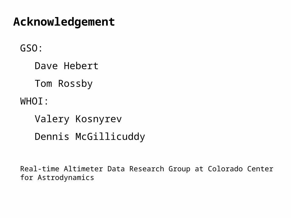
Acknowledgement
GSO:
Dave Hebert
Tom Rossby
WHOI:
Valery Kosnyrev
Dennis McGillicuddy
Real-time Altimeter Data Research Group at Colorado Center for Astrodynamics
CLS Space Oceanography Division


longitude
latitu
de
rms SLA (mm)
38oW 34oW 30oW 26oW 22oW 18oW
2oN
4oN
6oN
8oN
10oN
12oN
10 15 20 25 30 35 40 45 50

RDV=0.1

RDV=3