Embed Size (px)
Citation preview

SUPPORTING EVIDENCE FOR A CONFORMABLE SOUTHERN CONTACT OF THE BOWSER LAKE AND SKEENA GROUPS
Gareth T. Smith1 and Peter S. Mustard1
ABSTRACT New geologic mapping in the Hazelton and immediately adjacent map areas has clarified both Bowser Lake
Group (BLG) stratigraphy in this area and the relationship of this strata to the overlying Early Cretaceous Skeena Group. The upper unit of the BLG in this area comprises a sandstone-dominated, shallow marine succession, which can be lithostratigraphically correlated to the Muskaboo Creek assemblage that is well documented from the central and northern Bowser Basin. In three widely separate geographic locations, this shallow marine succession gradationally changes upward into a nonmarine unit that has previously been considered to be a stratigraphic unit either of the Cretaceous Skeena Group or undivided Bowser/Skeena strata. These new sections confirm our previous hypothesis that the Skeena Group gradationally overlies the Bowser Lake Group and represents a southern nonmarine component of an originally contiguous Jura-Cretaceous Bowser Basin.
Gareth T. Smith and Peter S. Mustard, Supporting evidence for a conformable southern contact of the Bowser Lake and Skeena groups in Summary of Activities 2006, BC Ministry of Energy, Mines and Petroleum Resources, pages 125-134. 1Department of Earth Sciences, Simon Fraser University, Burnaby, BC, V5A 1S6
Keywords: Sedimentology, stratigraphy, Muskaboo Creek Assemblage, Skeena Group, Bowser Lake Group, Cretaceous, Jurassic
INTRODUCTION Recent efforts have been made by the BC Ministry of
Energy and Mines (BCMEM) and the Geological Survey of Canada (GSC) to improve the structural and geological knowledge of the Jurassic-Cretaceous Bowser Basin of northeast BC (Figure 1), as well as to assess its integrated petroleum resource potential (Hayes et al., 2004, Evenchick et al., 2003). During the summers of 2004 and 2005, this research focused on the southern and central parts of the extensive Bowser Basin NTS map sheets 93M and 104A (summarized in Ferri et al., 2005, Evenchick et al., 2005, 2006 respectively).
The Bowser Lake Group (BLG) consists of sedimentary rocks of late Middle Jurassic to “mid” Cretaceous age, and is the oldest of the three major stratigraphic successions that comprise the Bowser Basin and related sedimentary rocks (Figure 2). The southern-most region of the BLG in the Hazleton map sheet (NTS sheet 93M) is dominated by shallow marine siliciclastics, which on extant geologic maps are defined as “undivided Bowser Lake Group” (e.g., Richards, 1990). Outcropping south of the BLG, a second stratigraphic succession of Lower to Upper Cretaceous rocks is generally termed the Skeena Group (SG). This unit has been interpreted to record predominantly nonmarine fluvial/floodplain and shallow marine environments with localised volcanic influence (e.g. Basset, 1995; Bassett and Kleinspehn 1997). The stratigraphic relationship between the undivided BLG and the nonmarine sedimentary rocks of the Skeena Group in the southern-most region of the Bowser Basin remains unclear. Previous workers have suggested that the contact is unconformable, or a fault contact (Tipper and Richards, 1976), or that the Skeena
Group sediments represent the Cretaceous continuation of Bowser Basin deposition (Bassett and Kleinspehn 1997). Ferri et al. (2005) summarizes previous studies in this area and the complex evolution of stratigraphic terms involving the stratigraphy now termed “Skeena Group” and “Bowser Lake Group” in this region.
PROJECT GOALS This project characterizes the shallow marine
siliciclastic unit, which appears to be the upper most stratigraphic unit of the BLG within the Hazelton map area and immediately adjacent regions. The projects aim is to describe this unit in terms of its sedimentological make-up and depositional history. Ultimately this unit will be compared to previous studies of similar lithostratigraphic units in the BLG and Skeena Group, in order to discern whether they are correlative. A second major goal of this project is to more clearly define and differentiate the BLG contact nature with the overlying Skeena Group.
WORK TO DATE Much of the initial part of this project involved
assisting in the regional mapping of the west half of the Hazelton map area, to define local and regional stratigraphic relationships as well as to view the lateral variance of the undivided BLG and their regional interrelationships (summarized in Ferri et al., 2005).
Summary of Activities 2006 125

Figure 1. Location of the Bowser, Sustut and Skeena groups within the geological framework of the Canadian Cordillera. Outlined box represents area of investigation during the 2005 field season (modified from Ferri et al., 2005 and Evenchick et al., 2003).
Mapping in the summer of 2005 continued into the eastern Hazelton map area (93M topographic sheet) with regional examinations extending west into the Nass River map area (103P topographic sheet). New results are summarized in Evenchick et al., 2006).
In conjunction with (and, in part, a result of) the geologic mapping, eight stratigraphic section localities were chosen in 2004 (see Smith and Mustard, 2005) and two new sections identified in 2005. Our selection of the localities were limited to areas that were previously mapped as undivided Bowser Lake Group, Skeena Group, or areas which have been mapped to show transitional characteristics from possible BLG into Skeena Group. These selections were made as a result of the new geological mapping and with reference to previous work documented by Bassett (1995) and Tipper and Richards (1976).
In like manner for the 2004 sections, each 2005 location entailed the construction of a detailed stratigraphic measured section. In the majority of cases, a basal contact was not identified, and therefore measurement began from the clearest exposed surface.
Thus these sections do not represent the total thickness of the stratigraphic unit. Each measured section comprises a detailed lithostratigraphic description, identification of primary sedimentary structures, internal gradational relationships and inference of depositional nature. Suitable hand samples were taken at each site to permit petrographic identification and thin section analysis, as well as maturation and palynology samples from the more carbonaceous layers, to assist in possible age determinations and reservoir potential.
Smith and Mustard (2005) concluded that shallow marine strata of the Hazelton map area correspond to the Muskaboo Creek assemblage of the Bowser Lake Group, as described in more northern occurrences. It was also determined that at one locality the shallow marine succession changes upward across a transitional contact into non-marine strata typical of lower Skeena Group as described by previous workers. It was suggested that this conformable relationship might be typical for much of this southern margin of the known extent of the Bowser Lake Group. During 2005, examination of both shallow marine BLG and lower Skeena Group strata continued in eastern Hazelton map
USABC
BC
USA
YTNWT
AB
500 km
Foreland
Om
ineca
Intermontane
Om
ineca
InsularC
oast
Eastern
n
Limit
a
r
of
f
Co
r
n
dilleraDe
om
tio
Bowser Lake Group
Legend
Sustut Group
Skeena Group
Stikine Terrane
Quesnel Terrane
Cache Creek Terrane
Geomorphological Belts
study area
126 British Columbia Resource Development and Geoscience Branch

Figure 2. General geology of the Bowser Basin region, showing the location of measured sections B and C, described in this paper. Section A was described in Smith and Mustard (2005). Main figure modified from Ferri et al., (2005) and Evenchick et al., (2003).
Stewart
Houston
Kitimat
Smithers
Terrace
NewAiyansh
PrinceRupert
104H 94E
94D
93M
93L
104A
103P
103I
104B
104G
NTS map areas93L Smithers93M Hazelton94D McConnell Creek94E Toodoggone River103I Terrace103P Nass River104A Bowser Lake104B Iskut River104G Telegraph Creek104H Spatsizi River
57 No
58 No
56 No
54 No
128 Wo130 Wo 126 Wo
Tertiary intrusive rocksCretaceous intrusive rocksJurassic intrusive rocksTriassic intrusive rocks
Tertiary and younger volcanic rocksSustut Basin rocks (Cretaceous)Bowser Basin rocks (Jurassic, Cret.)Hazelton and Stuhini groups (Triassic and Jurassic volcanic arc rocks) and minor older strata
oil stain locations discussed in texthighwaystowns, citiesrivers, coastlineTransition section locations
IskutTatoggaLake
TsatiaMountain
triangle zone
BuckinghorseCreek
OweegeeDome
Mt. RitchieRitchiewells
CANADAU.S.A.
Summary of Activities 2006 127
area and southeast Nass River map area. Two new examples of a gradational contact between these units were identified and measured in detail, as described below and located on Figure 2.
NEW EXAMPLES OF GRADATIONAL BOWSER-SKEENA TRANSITION
As part of general field mapping during the summer of 2005, two new examples of a marine to non-marine transition were identified from lithofacies of the Muskaboo Creek assemblage that are overlain by typical lower Skeena Group (Figure 2, localities B and C). Detailed measured sections characterize these contact relationships (Figures 4 and 5 with a common legend shown in Figure 3). These stratigraphic sections are significant not only because they provide additional examples of what appears to be a conformable BLG to Skeena Group contact, but also because they suggest that this contact is geographically widespread. They also illustrate slightly different shoreline depositional environments along this transition compared to that documented in 2004 (Smith and Mustard, 2005).
At the eastern example of this transitional contact (Figure 4 and locality B on Figure 2), the lowest part of the stratigraphy consists of sandstone and mudstone, generally typical of the Muskaboo Creek assemblage. This includes both trough and hummocky cross-stratified, medium-grained sandstone bedsets up to 2 m thick (Figure 4B, D.). Stacked repetitions of these bedsets are intercalated with wavy rippled sandstone and mudstone, in some places including heterolithic sandstone-mudstone flaser or lenticular composite bedsets. Trace fossils are somewhat rare in this succession, but include vertical and horizontal simple ichnogenera including Skolithos and Ophiomorpa and possibly some poorly preserved Diplocrateron. In addition, the lower part of the section includes a few metres of repeated intervals of normally graded, fine-grained sandstone to mudstone couplets, each a few centimetres to, at most, 5 cm thick (Figure 4C). These appear to be stacked, thin turbidites (mostly Bouma ABE divisions), and are somewhat unusual compared to typical Muskaboo Creek assemblage lithofacies.
The transitional zone identified at this section occurs over approximately 60 m of vertical section. Characteristic cycles within this transition consist of wave-dominated sandstone units, intercalated with laminated marine siltstone, periodically truncated by trough cross-stratified sandstone with abundant rip-up clasts and large plant and wood fragments. These latter channelised units appear to progressively fine upwards into silty mudstone and plant-rich sandstone packages, gradationally overlain by ever-thinning units of interlaminated sandstone and siltstone. In the upper part of this transitional zone is an uncharacteristically thick (approximately 6 m) section of heavily reworked, wave-rippled, heterolithic sandstone-siltstone. This package, possibly indicative of reworked deltaic bottomset turbidites, marks the last visible, marine-dominated cycle in this transitional zone.
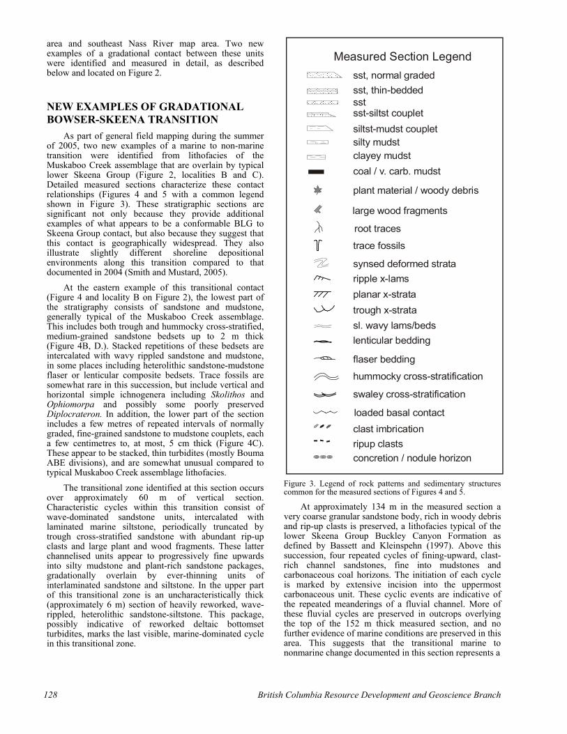
Figure 3. Legend of rock patterns and sedimentary structures common for the measured sections of Figures 4 and 5.
At approximately 134 m in the measured section a very coarse granular sandstone body, rich in woody debris and rip-up clasts is preserved, a lithofacies typical of the lower Skeena Group Buckley Canyon Formation as defined by Bassett and Kleinspehn (1997). Above this succession, four repeated cycles of fining-upward, clast-rich channel sandstones, fine into mudstones and carbonaceous coal horizons. The initiation of each cycle is marked by extensive incision into the uppermost carbonaceous unit. These cyclic events are indicative of the repeated meanderings of a fluvial channel. More of these fluvial cycles are preserved in outcrops overlying the top of the 152 m thick measured section, and no further evidence of marine conditions are preserved in this area. This suggests that the transitional marine to nonmarine change documented in this section represents a
Measured Section Legendsst, normal gradedsst, thin-beddedsstsst-siltst coupletsiltst-mudst coupletsilty mudstclayey mudstcoal / v. carb. mudst
trace fossils
ripple x-lamsplanar x-stratatrough x-stratasl. wavy lams/bedslenticular bedding
flaser bedding
hummocky cross-stratification
swaley cross-stratification
clast imbricationripup clastsconcretion / nodule horizon
plant material / woody debris
large wood fragments
synsed deformed strata
loaded basal contact
root traces
128 British Columbia Resource Development and Geoscience Branch

Figure 4. A. Measured section C in the east Hazelton map area; located on Figure 2. Photos B to E are located on the measured section. B. Overview of lower 30+ m of section, dominated by cross-stratified sandstone typical of Muskaboo Creek assemblage C. Rare repeated thinly bedded sandstones and mudstones showing good normal grading, are interpreted as delta bottomset turbidites in areas not reworked by high-energy shoreface waves. D. Cross-stratified sandstone typical of much of the lower part of this section. E. Thick sandstone bedset with irregular basal contact erosive into underlying coaly sandstones, contains common mudstone rip-up clasts and plant fragments, including large wood fragments (directly above scale bar), passing upward into current rippled sandstone (highest bed plane on left side of photo).
Summary of Activities 2006 129

Figure 5. Measured section A in Nass River map area; located on Figure 2. Photographs from this measured section are shown in Figure 6.
0
62 122
2
64 124
4
66 126
6
68 128
8
70 130
10
72
74
76
132
134
136
16
78 138
18
80 140
20
82 142
22
84 14426
88 148
28
90 150
30
92 152
32
94 154
34
96 156
36
98
38
100
40
102
42
104
44
106
46
108
met
res
48
110
50
112
52
114
54
116
56
118
58
120
60
62
cove
rm
udst
sil ts
t sst cgl
cove
rm
udst
silt s
t sst cgl
cove
rm
u ds t
s ilts
t sst cgl
160
162
164
168
170
172
174
176
178
180
182
184
81
cove
rm
udst
s ilt s
t sst cgl
80
79siltstone
trough cross-stratified sandstone
slightly wavy laminated sandstone
planar laminatedsandstone
Detailed example of interpreted estuarinechannel incised into a plant-rich siltstone.
metres
130 British Columbia Resource Development and Geoscience Branch

Figure 6. Measured section C photographs: A. Overview of the entire measured section from right to left (south to north). MC = Muskaboo Creek assemblage; Sk = lower Skeena Group strata. B. Approximately lower 50 m of section, dominated by sandstone bedsets with marine indicators, which we interpret as the upper part of the Muskaboo Creek assemblage. C. Fine-grained, laminated wavy sandstone to heterolithic sandstones and mudstones of the Muskaboo Creek assemblage. D. Plant-rich silty mudstones overlain across an erosive contact by fining upward sandstones, as shown in expanded part of section C at 79-81 metres. E. Wavy to current rippled sandstone within the transitional interval of the section.
Summary of Activities 2006 131

regional gradational contact between the two lithostratigraphic units.
The depositional environments represented by this section appear to be indicative of a marine shoreline with high energy, wave-dominated shoreface successions with minor deltaic input, passing upward to a nonmarine setting dominated by small river channel systems. In the lower part of the section the dominance of higher energy open shoreface structures (trough and hummocky cross-stratified sandstone) is typical of Muskaboo Creek assemblage elsewhere in the Bowser Lake Group. Less typical of the Muskaboo Creek are the presence of a few examples of fine-grained sandstone to mudstone turbidites, in some examples well-preserved over a few metres thickness (Figure 4C), but in others slightly reworked into more heterolithic thinly bedded sandstone-mudstone composite bedsets. We interpret these as remnants of small deltaic bottomset deposits, perhaps representing small protruding fluvial-dominated delta successions, that have been largely reworked by strong wave action into shoreface sand bodies, which by definition typically suggests a wave-dominated shoreline.
At the western example of this contact (Figure 5, and locality C on Figure 2), the lowest part of the stratigraphy consists of sandstone and siltstone, typical of the Muskaboo Creek assemblage. A thick succession of heterogeneous, laminated siltstones-sandstones and mudstones, exhibiting abundant wave ripples and lenticular stratification with little bioturbation, dominates the first 30m of this section. This unit is overlain by an asymmetrical current rippled, fining upward sandstone body, with two large concretionary horizons, all capped by heavily rooted, muddy siltstone. This fining cycle occurs commonly within the Muskaboo Creek assemblage elsewhere, and may be explained by the possible influence of an estuarine channel within an otherwise high-energy, shoreline dominated succession. This typical mixed marine facies succession remains sedimentologically consistent for a considerable thickness (~ 60 m).
The interval encompassing the transitional contact is poorly exposed in this section, occurring over a considerable vertical thickness (~ 60 m), with the unfortunate presence of abundant covered intervals. The general transitional nature is characterized by the first occurrence of repeated fining-upward successions, each a few metres thick, with bases of coarse-grained to granular, trough cross-stratified sandstones rich with plant and woody debris. These initial cycles are, in turn, overlain by wave-rippled sandstones and siltstones locally including flaser bedding, with only minor bioturbation. Further up section, these apparently cyclic fining-upward sandstone successions occur more commonly and as thicker bedsets (up to 10 m). Cycles are characterised by coarse–grained, debris-rich basal channel sandstones passing upward into rootlet-rich siltstones.
The depositional environment represented by this section appears to be one of a lower energy marine shoreline succession, characterized by abundant heterolithic flaser and wave rippled, fine- to medium-grained sandstone with a high silt percentage, and a low abundance of trace fossils, upward into a non marine area
dominated by fluvial successions. Atypical of the upper Muskaboo Creek assemblage is the distinct lack of high-energy shoreface deposits, being possibly explained by an estuarine influence in this area.
The progressive interfingering of marine to marginal marine and fluvial successions is unusual, compared to the other examples of this transitional contact. Only in the top 30 metres of the section do the strata consistently represent the typical lower Skeena Group fluvial successions. Stratigraphically above this section are several tens of metres of similar repeated, stacked fluvial cycles (not measured), suggesting the transitional change of the measured section does represent a regional contact from the upper Muskaboo Creek assemblage through a thick gradational transition into typical lower Skeena Group.
CONCLUSIONS AND CONTINUED STUDY
The evidence from the 2005 field season provides strong additional support to the preliminary conclusions summarized in Smith and Mustard (2005). Shallow marine facies of typical Bowser Lake Group Muskaboo Creek assemblage are widespread in the study area, including both the eastern Hazelton map area and southeast Nass River map area. In addition, two new examples of a gradational contact from the marine Muskaboo Creek assemblage upward into non-marine strata typical of the lower Skeena Group were identified. These transitions are geographically widely separated from each other and the original example documented in Smith and Mustard (2005). This suggests that a conformable Bowser-Skeena contact exists across an extensive area of the southern limit of strata, previously interpreted as Bowser Lake Group or a Bowser-Skeena undivided map unit. Age controls which will support this conclusion await the analysis of abundant palynology samples and several isotope geochemistry samples from above and below the suggested transitional contact. If the widely separated contacts prove to be of similar age, this suggests a geographically extensive southern shoreline for the Bowser Basin at this time, and one in which major river systems do not appear to be dominating the sedimentation patterns.
ACKNOWLEDGEMENTS Logistical support and advice during the 2005 field
season was provided by Carol Evenchick of the Geological Survey of Canada. Filippo Ferri of the B.C. Resource Development and Geoscience Branch also provided helpful advice. We are grateful to John Waldron from the University of Alberta, who first recognized during regional mapping the significance of the transitional change in lithofacies in the east part of the Hazelton map area which we later measured as section B. We thank James MacEachern for a constructive review of the manuscript. This project was directly supported by grants to Mustard from the B.C. Ministry of Energy and Mines (Grant ca80405002) and NSERC (Grant 184290).
132 British Columbia Resource Development and Geoscience Branch

REFERENCES Bassett, K.N. (1995): A basin analysis of the Lower to mid-
Cretaceous Skeena Group, west-central British Columbia: implications for regional tectonics and terrane accretion; Ph.D. Thesis, Volume 1, pages 1-200.
Bassett, K.N. and Kleinspehn, K.L. (1997): Early to middle Cretaceous paleogeography of north-central British Columbia: stratigraphy and basin analysis of the Skeena Group; Canadian Journal of Earth Sciences, Volume 34, pages 164–1669.
Evenchick, C.A. and the Bowser Project Team (2006): The Bowser / Sustut project: Introduction, overview of project status, and highlights of recent research; Bowser Project workshop (BC Intermontane workshop), Feb.21, 2006, Calgary, AB.
Evenchick, C.A. and Thorkelson, D.J. (2005): Geology of the Spatsizi River map area, north-central British Columbia; Geological Survey of Canada, Bulletin 577, 288 pages, includes A-series maps 2028A - 2039A.
Evenchick, C.A., Ferri, F., Mustard, P.S., McMechan, M., Osadetz, K.G., Stasuik, L., Wilson, N.S.F., Hadlari, T. and McNicoll, V.J. (2003): Recent results and activities of the integrated petroleum resource potential and geoscience studies of the Bowser and Sustut basins project, British Columbia; Current Research, Geological Survey of Canada, Volume 2003-A13, pages 1-11.
Ferri, F., Mustard, P., McMechean, M., Ritcey, D., Smith, G., Evenchick, C. and Boddy, M. (2005): Skeena and Bowser Lake groups, west half Hazelton map area (93M): Resource Development and Geoscience Branch, British Columbia Ministry of Energy and Mines, Summary of Activities 2005, pages 113 – 131.
Hayes, M., Ferri, F. and Morii, S. (2004): Interior Basins Strategy; Resource Development and Geoscience Branch, British Columbia Ministry of Energy and Mines, Summary of Activities 2004, pages 69-71.
Richards, T.A. (1990): Geology of Hazleton map area (93M); Geological Survey of Canada, Open File 2322.
Smith, G.T. and Mustard, P.S. (2005): The Southern Contact of the Bowser Lake and Skeena Groups: Unconformity or Transition? Resource Development and Geoscience Branch, British Columbia Ministry of Energy and Mines, Summary of Activities 2005, pages 152-156.
Tipper, H.W. and Richards, T.A. (1976): Jurassic stratigraphy and history of North-central British Columbia; Geological Survey of Canada, Bulletin 270, pages 1-73.
Summary of Activities 2006 133

134 British Columbia Resource Development and Geoscience Branch