Embed Size (px)
Citation preview
Supplemental Filing Middle Fork American River Project (FERC Project No. 2079)
November 2011 2-i
TABLE OF CONTENTS
Page
2.0 Elements Analyzed .............................................................................................. 2-1 2.1 Construction, Operation, and Maintenance of Four New Project Gages ... 2-1 2.2 Resource Agencies Preliminary Conditions and Recommendations ......... 2-2
2.2.1 Instream Flow and Reservoir Minimum Pool Conditions ............... 2-2
2.2.2 Recreation Plan ............................................................................. 2-3
2.3 Stakeholder Agreed Upon Management Plans ......................................... 2-4 2.3.1 Vegetation and Integrated Pest Management Plan ....................... 2-4
2.3.2 Transportation System Management Plan .................................... 2-5
2.3.3 Draft Final Historic Properties Management Plan .......................... 2-5
Supplemental Filing Middle Fork American River Project (FERC Project No. 2079)
November 2011 2-ii
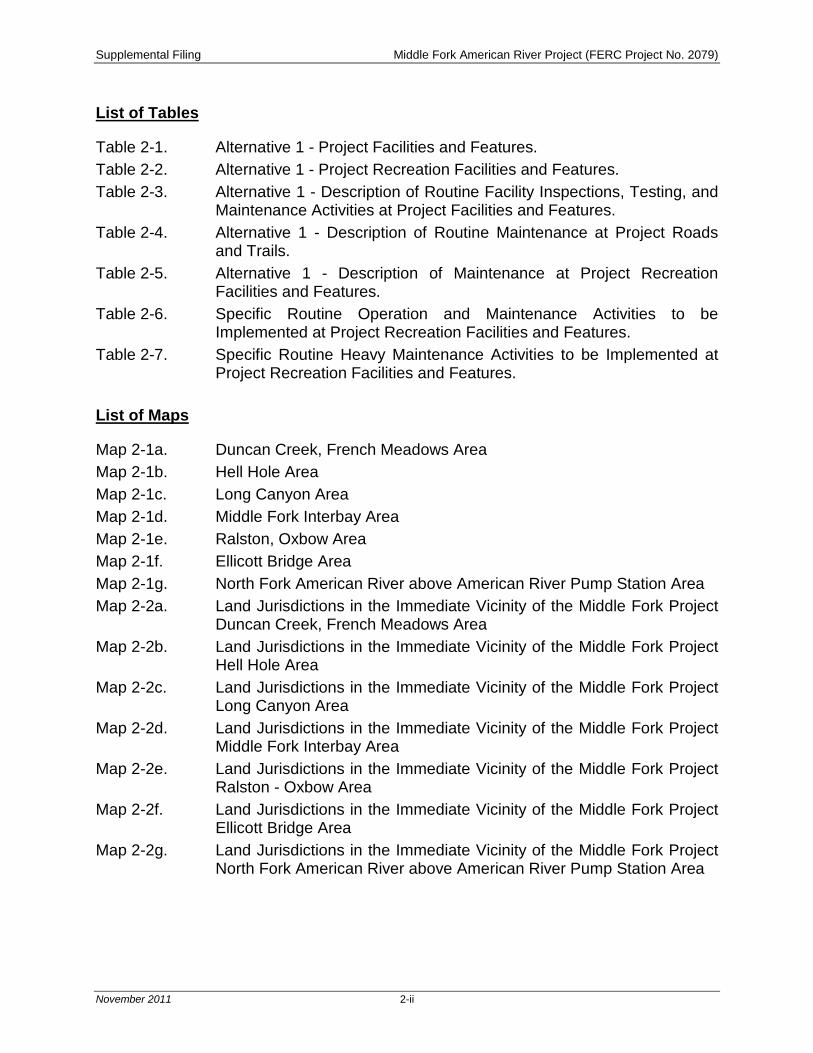
List of Tables
Table 2-1. Alternative 1 - Project Facilities and Features. Table 2-2. Alternative 1 - Project Recreation Facilities and Features. Table 2-3. Alternative 1 - Description of Routine Facility Inspections, Testing, and
Maintenance Activities at Project Facilities and Features. Table 2-4. Alternative 1 - Description of Routine Maintenance at Project Roads
and Trails. Table 2-5. Alternative 1 - Description of Maintenance at Project Recreation
Facilities and Features. Table 2-6. Specific Routine Operation and Maintenance Activities to be
Implemented at Project Recreation Facilities and Features. Table 2-7. Specific Routine Heavy Maintenance Activities to be Implemented at
Project Recreation Facilities and Features.
List of Maps
Map 2-1a. Duncan Creek, French Meadows Area Map 2-1b. Hell Hole Area Map 2-1c. Long Canyon Area Map 2-1d. Middle Fork Interbay Area Map 2-1e. Ralston, Oxbow Area Map 2-1f. Ellicott Bridge Area Map 2-1g. North Fork American River above American River Pump Station Area Map 2-2a. Land Jurisdictions in the Immediate Vicinity of the Middle Fork Project
Duncan Creek, French Meadows Area Map 2-2b. Land Jurisdictions in the Immediate Vicinity of the Middle Fork Project
Hell Hole Area Map 2-2c. Land Jurisdictions in the Immediate Vicinity of the Middle Fork Project
Long Canyon Area Map 2-2d. Land Jurisdictions in the Immediate Vicinity of the Middle Fork Project
Middle Fork Interbay Area Map 2-2e. Land Jurisdictions in the Immediate Vicinity of the Middle Fork Project
Ralston - Oxbow Area Map 2-2f. Land Jurisdictions in the Immediate Vicinity of the Middle Fork Project
Ellicott Bridge Area Map 2-2g. Land Jurisdictions in the Immediate Vicinity of the Middle Fork Project
North Fork American River above American River Pump Station Area
Supplemental Filing Middle Fork American River Project (FERC Project No. 2079)
November 2011 2-1
2.0 ELEMENTS ANALYZED
The following describes elements analyzed in this Supplemental Filing including:
• Construction, operation, and maintenance of four Project gages and associated features proposed in Placer County Water Agency’s (PCWA’s) Application for New License (herein, referred to as the Final License Application [FLA]) for the Middle Fork American River Project (MFP or Project) (PCWA 2011);
• Instream flow and reservoir minimum pool conditions provided in the United States Department of Agriculture-Forest Service (USDA-FS) preliminary Section 4(e) conditions (USDA-FS 2011), California Department of Fish and Game (CDFG) Section 10(j) recommendations (CDFG 2011), and United States Department of the Interior (DOI) Section 10(a) recommendations (DOI 2011);
• Additional recreation enhancements (facilities and features) in the Recreation Plan provided in USDA-FS preliminary Section 4(e) conditions and CDFG Section 10(j) recommendations;
• Vegetation and pest management activities described in the revised Vegetation and Integrated Pest Management Plan (VIPMP) (Attachment 1A) agreed upon by the MFP stakeholders in November 2011;
• Road and trail maintenance activities described in the revised Transportation System Management Plan (TSMP) (Attachment 1B) agreed upon by MFP stakeholders in November 2011;
• Project effects on cultural resources with consideration of site-specific management measures and general procedural requirements described in the Draft Final Historic Properties Management Plan (HPMP) (Volume 3) agreed upon by MFP stakeholders in November 2011.
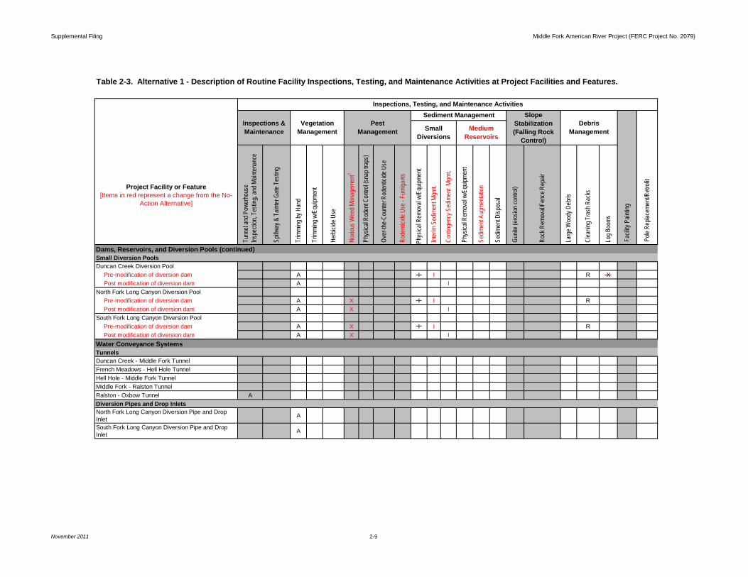
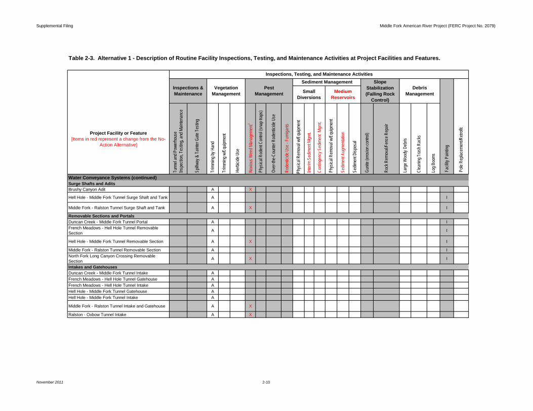
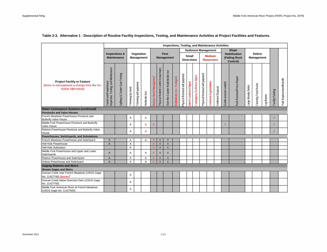
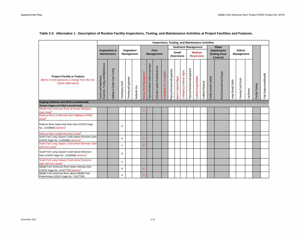
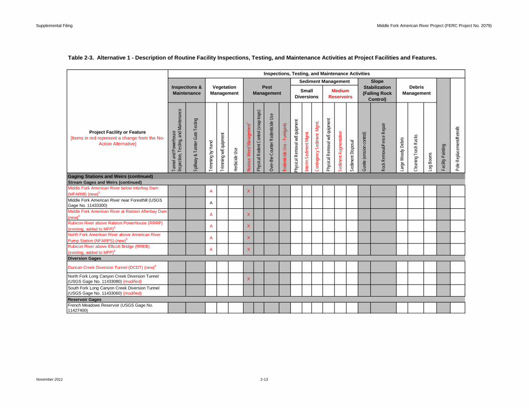
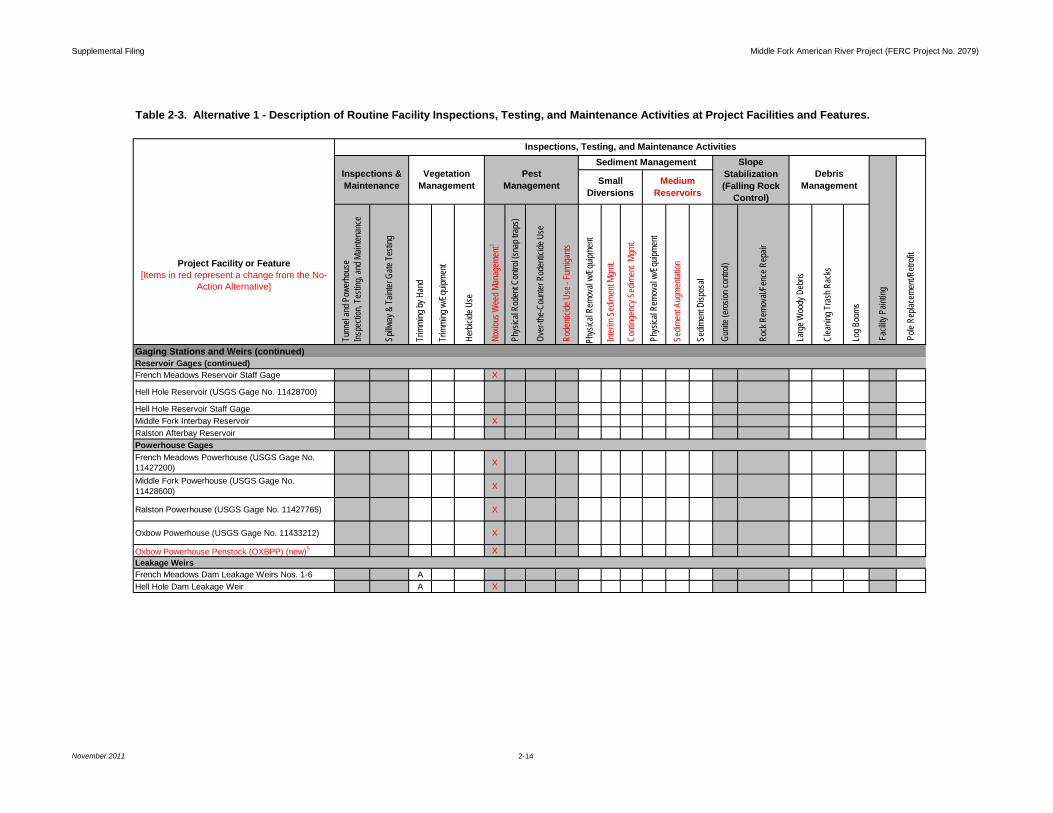
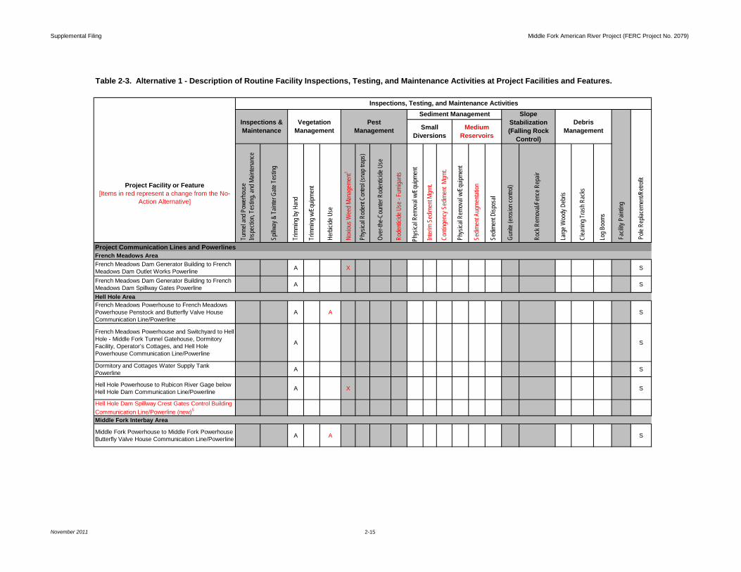
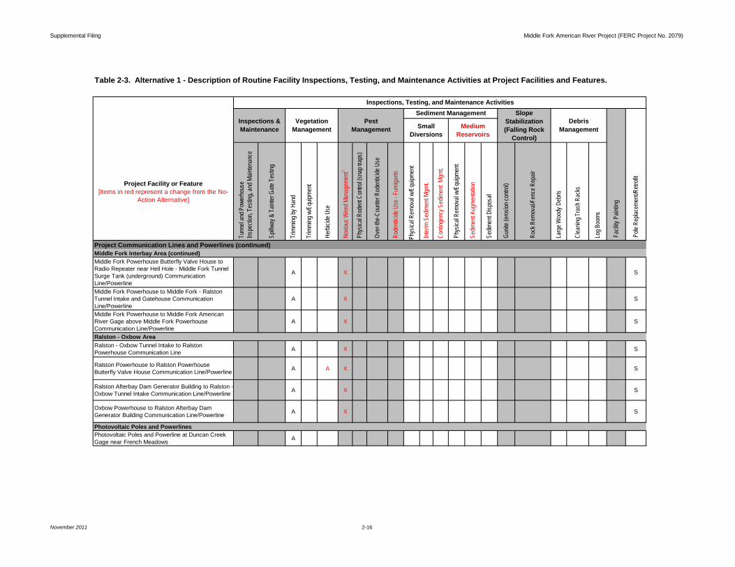
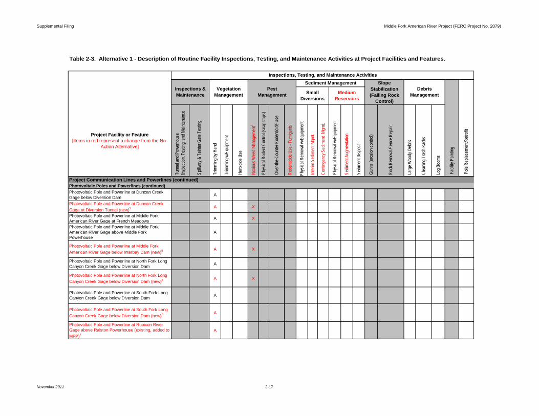
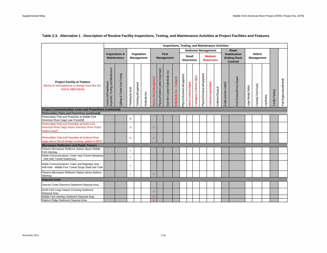
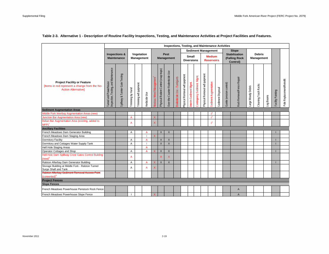
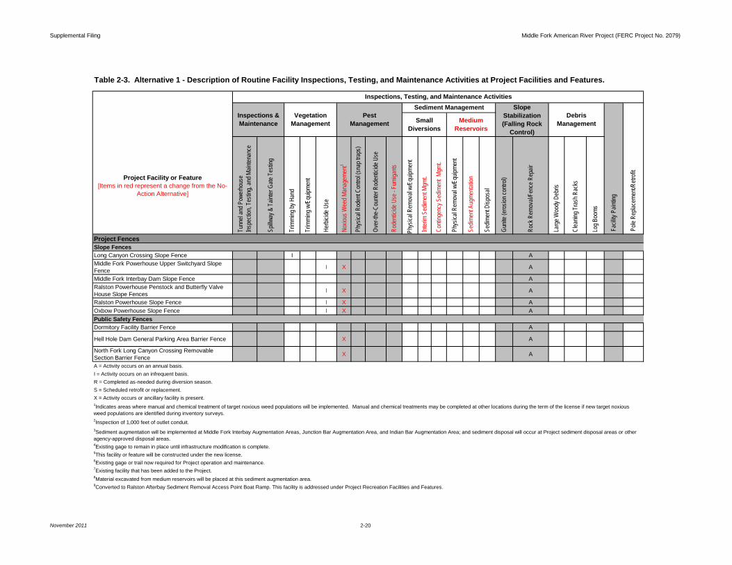
Project facilities and features, and Project recreation facilities and features included in this analysis are listed in Tables 2-1 and 2-2. Tables 2-3 through 2-7 include information related to routine facilities inspections, testing, and maintenance activities at Project facilities and features, Project roads and trails, and Project recreation facilities and features, respectively. The location of Project facilities and features and Project recreation facilities and features are depicted on Maps 2-1a-g and Maps 2-2a-g. Each element analyzed is described in detail below.
2.1 CONSTRUCTION, OPERATION, AND MAINTENANCE OF FOUR NEW PROJECT GAGES
The FLA identified four new gages and associated features to be constructed as part of PCWA’s Proposed Action at the following locations:
• North Fork Long Canyon Creek below Diversion Dam; • South Fork Long Canyon Creek below Diversion Dam; • Middle Fork American River below Interbay Dam; and • North Fork American River above American River Pump Station.
Supplemental Filing Middle Fork American River Project (FERC Project No. 2079)
November 2011 2-2
At the time of submittal of the FLA, the precise location of these gages had not been determined. In the FLA, Section 4.1.6.1, PCWA stated that “Project-specific National Environmental Policy Act (NEPA) analysis will be conducted at a later date and all necessary permits and approvals will be obtained prior to implementation of any construction activities”. Following submittal of the FLA, PCWA developed the necessary information to complete environmental analysis on the four new gages under NEPA, including: (1) identification of the specific location of the gages; (2) development of site-specific construction activities; (3) description of future operation and maintenance activities; and (4) identification of biological and cultural resources in the vicinity of the proposed new gages and associated features.
PCWA will be responsible for construction, operation, and maintenance of each new gage and its associated features. Refer to Appendix A – Modified or New Facilities Construction Activities and Concept Designs for detailed information on construction activities and schedule; associated Best Management Practices (BMPs) and avoidance and protection measures (AP) (as applicable); and concept design drawings and/or maps for each new facility. Refer to Table 2-3 for maintenance activities that will occur at each new gage.
Section 3.0 describes potential impacts on environmental and cultural resources from construction, operation, and maintenance of the new gages and associated features. This analysis is supported by supplemental biological and cultural surveys conducted by PCWA in spring and summer 2011 (Attachment 2A; Volume 3).
2.2 RESOURCE AGENCIES PRELIMINARY CONDITIONS AND RECOMMENDATIONS
The following provides details of the resource agencies preliminary conditions and recommendations analyzed in this Supplemental Filing.
2.2.1 Instream Flow and Reservoir Minimum Pool Conditions
Specific resource agencies instream flow and reservoir minimum pool conditions proposed in USDA-FS preliminary Section 4(e) conditions, CDFG Section 10(j) recommendations, and DOI Section 10(a) recommendations include:
USDA-FS Preliminary Section 4(e) Conditions and CDFG Section 10(j) Recommendations
• Condition No. 22 – Minimum Streamflows; • Condition No. 23 – Pulse Flows; • Condition No. 24 – Ramping Rates; • Condition No. 25 – Outages; • Condition No. 39 – Recreation Streamflows in the Middle Fork American River
Below Oxbow Powerhouse; and • Condition No. 37 – Reservoir Minimum Pool Elevations and Reservoir Levels
Recreation Objectives.
Supplemental Filing Middle Fork American River Project (FERC Project No. 2079)
November 2011 2-3
DOI Preliminary Section 10(a) Recommendations
• b2. – Minimum Streamflows;
• b3. – Peaking Reach Ramping Rate and Oxbow Powerhouse Operations;
• b4. – Outages; and
• b5. – Recreation Streamflows in the Middle Fork American River below Oxbow Powerhouse.
Section 3.0 describes potential impacts on environmental and cultural resources from implementation of resource agencies instream flow and reservoir minimum pool conditions.
2.2.2 Recreation Plan
The Recreation Plan proposed in USDA-FS preliminary Section 4(e) conditions and CDFG Section 10(j) recommendations includes the following enhancements (facilities and features):
Existing Recreation Trails Added to MFP
• Poppy Trail;
• Hell Hole Reservoir Trail; and
• Middle Fork American River above Ralston Afterbay Trail.
PCWA will be responsible for routine operation and maintenance, and heavy maintenance of these trails.
New Recreation Facilities and Features
• French Meadows Reservoir Trail; and
• Ellicott Bridge Parking Area.
PCWA will be responsible for construction, routine operation and maintenance, and heavy maintenance of these recreation facilities and features.
Replacement of Existing Recreation Features
• French Meadows North Shore Water Supply; and
• French Meadows South Shore Water Supply.
PCWA will be responsible for construction, routine operation and maintenance, and heavy maintenance of these existing water supply lines. The FLA described these facilities as being repaired and maintained under “routine heavy maintenance” activities (i.e., “repair and maintenance of potable water tanks, supply and distribution lines, and
Supplemental Filing Middle Fork American River Project (FERC Project No. 2079)
November 2011 2-4
valves and faucets”). In resource agencies preliminary conditions and recommendations, both of the French Meadows water supply systems will undergo more extensive improvements than previously contemplated in the FLA, and therefore are considered construction projects rather than heavy maintenance activities.
Routine operation and maintenance activities and routine heavy maintenance activities at Project recreation facilities and features included under Alternative 1 are identified on Tables 2-6 and 2-7, respectively. Construction activities required to implement the Recreation Plan are provided in Appendix A – Modified or New Facilities Construction Activities and Concept Designs. Appendix A also identifies associated BMPs and AP measures (as applicable), and concept design drawings and/or maps for each new facility.
Section 3.0 describes potential impacts on environmental and cultural resources from construction, operation, and maintenance of the recreation facilities and features included in the Recreation Plan. This analysis is supported by supplemental biological and cultural surveys conducted by PCWA in spring and summer 2011.
2.3 STAKEHOLDER AGREED UPON MANAGEMENT PLANS
In November 2011, PCWA and MFP stakeholders reached consensus on revisions to the VIPMP (Attachment 1A), TSMP (Attachment 1B), and HPMP (Volume 3). It is anticipated that the resource agencies will be filing with FERC these revised stakeholder agreed upon management plans as modified preliminary terms and conditions for the MFP. The attached stakeholder agreed upon VIPMP, TSMP, and HPMP are analyzed in this Supplemental Filing. Each management plan is described below.
2.3.1 Vegetation and Integrated Pest Management Plan
The VIPMP includes: (1) Project facilities and features, Project roads and trails, and Project recreation facilities and features identified in PCWA’s Proposed Action where vegetation and pest management is implemented; and (2) additional recreation facilities and features identified in the Recreation Plan provided in USDA-FS preliminary Section 4(e) conditions and CDFG Section 10(j) recommendations.
The VIPMP describes vegetation management (i.e., trimming by hand or with equipment and use of herbicides, surfactants, and fungicides) and pest management activities (i.e., noxious weed management and rodent control) to be implemented at Project facilities and features, Project roads and trails, and Project recreation facilities and features, as well as measures for the enhancement and/or protection of environmental and cultural resources during implementation of these activities.
Pest management conducted under the VIPMP includes both noxious weed management and rodent control. The noxious weed management program includes manual/chemical treatment of noxious weeds, measures to reduce the introduction or spread of noxious weeds, and implementation of a noxious weed training program. This program will enhance habitat for native plant and wildlife species in the MFP and could
Supplemental Filing Middle Fork American River Project (FERC Project No. 2079)
November 2011 2-5
promote establishment of new special-status plant populations through improved habitat conditions by reducing competition with invasive noxious weeds.
Rodent control, which includes both physical control (e.g., snap traps) and rodenticide use (e.g., over-the-counter rodenticides and fumigants), is necessary to protect the structural integrity of dams and prevent rodent infestations in building interiors. The VIPMP includes specific rodenticide application methods to be used to protect water quality and prevent secondary effects on raptors and other scavengers.
The VIPMP also identifies several measures to avoid and protect environmental resources including special-status plant and noxious weed inventory surveys, Water Quality Monitoring for Chemical Treatment Program, Environmental Training Program (ETP), and annual consultation with resource agencies.
Section 3.0 describes potential impacts on environmental and cultural resources from implementation of vegetation and pest management activities in the VIPMP. This analysis is supported by supplemental biological and cultural surveys conducted by PCWA in spring and summer 2011.
2.3.2 Transportation System Management Plan
The TSMP includes: (1) Project roads, Project trails, and Project recreation facility access roads identified in the Proposed Action; and (2) additional Project trails and a Project recreation facility parking area identified in the Recreation Plan provided in USDA-FS preliminary Section 4(e) conditions and CDFG Section 10(j) recommendations.
The TSMP identifies PCWA’s responsibilities over the term of the new license related to the operation and maintenance of: (1) Project roads and trails; and (2) Project recreation facility access roads. Specific commitments and measures identified in the TSMP include funding of land management agency administrative oversight activities, implementation of routine annual and periodic maintenance activities, documenting road and trail conditions, implementation of special road and trail projects, and conducting traffic counts. The TSMP also includes measures for the protection of environmental and cultural resources and consultation with appropriate land management agencies. Measures to protect cultural resources during road and trail maintenance activities are provided in the HPMP.
Section 3.0 describes potential impacts on environmental and cultural resources from implementation of road and trail maintenance activities in the TSMP. This analysis is supported by supplemental biological and cultural surveys conducted by PCWA in spring and summer 2011.
2.3.3 Draft Final Historic Properties Management Plan
The HPMP addresses Project operation, maintenance and construction activities at: (1) Project facilities and features, Project roads and trails, and Project recreation facilities and features identified in PCWA’s Proposed Action; and (2) additional
Supplemental Filing Middle Fork American River Project (FERC Project No. 2079)
November 2011 2-6
recreation facilities and features identified in the Recreation Plan provided in USDA-FS preliminary Section 4(e) conditions and CDFG Section 10(j) recommendations.
The HPMP describes measures that PCWA will implement to manage the four properties located within the MFP Area of Potential Effect (APE) that are eligible for the National Register of Historic Places (NRHP). The HPMP also describes: (1) how PCWA will manage Project activities that may affect paleontological resources (although to date, none have been identified in the Project vicinity); and (2) monitoring of cultural resources within the APE over the term of the license. Measures to manage vegetation and pest management activities in the vicinity of potential traditional cultural properties (including traditional gathering areas) are included in the VIPMP.
Section 3.0 describes potential impacts on environmental and cultural resources from implementation of project activities included under Alternative 1. This analysis is supported by supplemental biological and cultural surveys conducted by PCWA in spring and summer 2011.
LITERATURE CITED California Department of Fish and Game (CDFG). 2011. Response to Notice of Ready
for Environmental Analysis, Federal Power Act Section 10(j) and 10(a) Recommendations, Middle Fork American River Project (FERC Project No. 2079-069). Filed with FERC August 5, 2011.
Placer County Water Agency (PCWA). 2011. Application for New License. Filed with FERC February 23, 2011.
United States Department of Agriculture-Forest Service (USDA-FS). 2011. Preliminary Section 4(e) Terms and Conditions, Middle Fork American River Project, FERC No. 2079. Filed with FERC August 5, 2011.
United States Department of the Interior (DOI). 2011. Middle Fork American River Project, FERC No. 2079-069, Department of the Interior’s Response to Commission’s June 7, 2011, Notice that Project is Ready for Environmental Analysis. Filed with FERC August 5, 2011.
Supplemental Filing Middle Fork American River Project (FERC Project No. 2079)
November 2011
TABLES
Supplemental Filing Middle Fork American River Project (FERC Project No. 2079)
November 2011 2-1
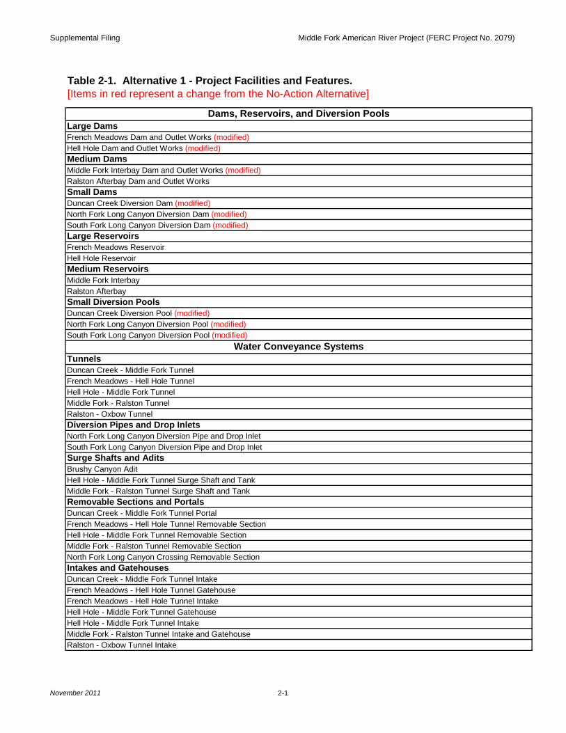
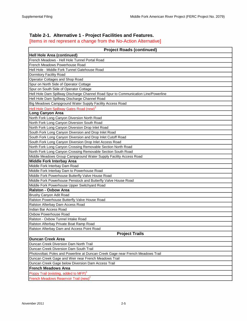
Table 2-1. Alternative 1 - Project Facilities and Features.[Items in red represent a change from the No-Action Alternative]
Dams, Reservoirs, and Diversion PoolsLarge DamsFrench Meadows Dam and Outlet Works (modified)Hell Hole Dam and Outlet Works (modified)Medium DamsMiddle Fork Interbay Dam and Outlet Works (modified)Ralston Afterbay Dam and Outlet Works Small DamsDuncan Creek Diversion Dam (modified)North Fork Long Canyon Diversion Dam (modified)South Fork Long Canyon Diversion Dam (modified)Large ReservoirsFrench Meadows ReservoirHell Hole ReservoirMedium ReservoirsMiddle Fork Interbay Ralston AfterbaySmall Diversion PoolsDuncan Creek Diversion Pool (modified)North Fork Long Canyon Diversion Pool (modified)South Fork Long Canyon Diversion Pool (modified)
Water Conveyance SystemsTunnelsDuncan Creek - Middle Fork TunnelFrench Meadows - Hell Hole TunnelHell Hole - Middle Fork TunnelMiddle Fork - Ralston TunnelRalston - Oxbow TunnelDiversion Pipes and Drop InletsNorth Fork Long Canyon Diversion Pipe and Drop InletSouth Fork Long Canyon Diversion Pipe and Drop InletSurge Shafts and AditsBrushy Canyon Adit Hell Hole - Middle Fork Tunnel Surge Shaft and TankMiddle Fork - Ralston Tunnel Surge Shaft and Tank Removable Sections and PortalsDuncan Creek - Middle Fork Tunnel PortalFrench Meadows - Hell Hole Tunnel Removable SectionHell Hole - Middle Fork Tunnel Removable SectionMiddle Fork - Ralston Tunnel Removable SectionNorth Fork Long Canyon Crossing Removable SectionIntakes and GatehousesDuncan Creek - Middle Fork Tunnel IntakeFrench Meadows - Hell Hole Tunnel GatehouseFrench Meadows - Hell Hole Tunnel IntakeHell Hole - Middle Fork Tunnel GatehouseHell Hole - Middle Fork Tunnel IntakeMiddle Fork - Ralston Tunnel Intake and GatehouseRalston - Oxbow Tunnel Intake
Supplemental Filing Middle Fork American River Project (FERC Project No. 2079)
November 2011 2-2
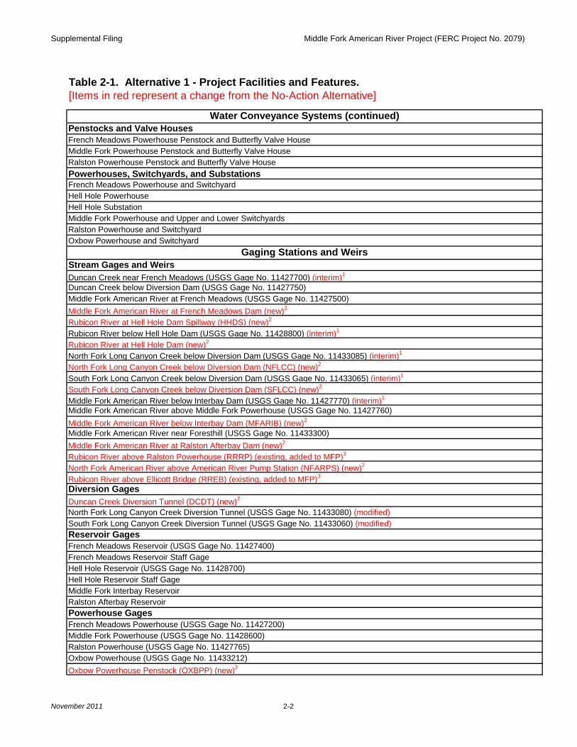
Table 2-1. Alternative 1 - Project Facilities and Features.[Items in red represent a change from the No-Action Alternative]
Water Conveyance Systems (continued)Penstocks and Valve HousesFrench Meadows Powerhouse Penstock and Butterfly Valve HouseMiddle Fork Powerhouse Penstock and Butterfly Valve HouseRalston Powerhouse Penstock and Butterfly Valve HousePowerhouses, Switchyards, and SubstationsFrench Meadows Powerhouse and SwitchyardHell Hole PowerhouseHell Hole SubstationMiddle Fork Powerhouse and Upper and Lower SwitchyardsRalston Powerhouse and SwitchyardOxbow Powerhouse and Switchyard
Gaging Stations and WeirsStream Gages and WeirsDuncan Creek near French Meadows (USGS Gage No. 11427700) (interim)1
Duncan Creek below Diversion Dam (USGS Gage No. 11427750)Middle Fork American River at French Meadows (USGS Gage No. 11427500)Middle Fork American River at French Meadows Dam (new)2
Rubicon River at Hell Hole Dam Spillway (HHDS) (new)2
Rubicon River below Hell Hole Dam (USGS Gage No. 11428800) (interim)1
Rubicon River at Hell Hole Dam (new)2
North Fork Long Canyon Creek below Diversion Dam (USGS Gage No. 11433085) (interim)1
North Fork Long Canyon Creek below Diversion Dam (NFLCC) (new)2
South Fork Long Canyon Creek below Diversion Dam (USGS Gage No. 11433065) (interim)1
South Fork Long Canyon Creek below Diversion Dam (SFLCC) (new)2
Middle Fork American River below Interbay Dam (USGS Gage No. 11427770) (interim)1
Middle Fork American River above Middle Fork Powerhouse (USGS Gage No. 11427760)Middle Fork American River below Interbay Dam (MFARIB) (new)2
Middle Fork American River near Foresthill (USGS Gage No. 11433300)Middle Fork American River at Ralston Afterbay Dam (new)2
Rubicon River above Ralston Powerhouse (RRRP) (existing, added to MFP)3
North Fork American River above American River Pump Station (NFARPS) (new)2
Rubicon River above Ellicott Bridge (RREB) (existing, added to MFP)3
Diversion GagesDuncan Creek Diversion Tunnel (DCDT) (new)2
North Fork Long Canyon Creek Diversion Tunnel (USGS Gage No. 11433080) (modified)South Fork Long Canyon Creek Diversion Tunnel (USGS Gage No. 11433060) (modified)Reservoir GagesFrench Meadows Reservoir (USGS Gage No. 11427400)French Meadows Reservoir Staff GageHell Hole Reservoir (USGS Gage No. 11428700)Hell Hole Reservoir Staff GageMiddle Fork Interbay ReservoirRalston Afterbay ReservoirPowerhouse GagesFrench Meadows Powerhouse (USGS Gage No. 11427200)Middle Fork Powerhouse (USGS Gage No. 11428600)Ralston Powerhouse (USGS Gage No. 11427765)Oxbow Powerhouse (USGS Gage No. 11433212)Oxbow Powerhouse Penstock (OXBPP) (new)2
Supplemental Filing Middle Fork American River Project (FERC Project No. 2079)
November 2011 2-3
Table 2-1. Alternative 1 - Project Facilities and Features.[Items in red represent a change from the No-Action Alternative]
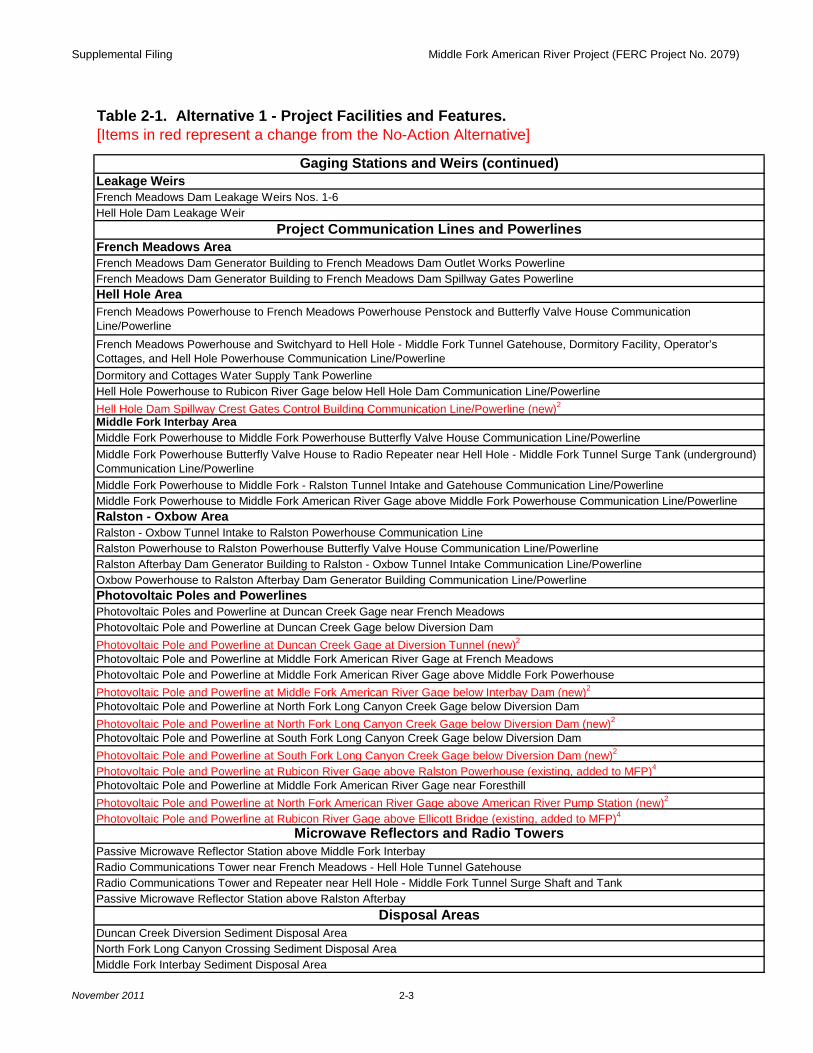
Gaging Stations and Weirs (continued)Leakage WeirsFrench Meadows Dam Leakage Weirs Nos. 1-6Hell Hole Dam Leakage Weir
Project Communication Lines and PowerlinesFrench Meadows AreaFrench Meadows Dam Generator Building to French Meadows Dam Outlet Works PowerlineFrench Meadows Dam Generator Building to French Meadows Dam Spillway Gates PowerlineHell Hole AreaFrench Meadows Powerhouse to French Meadows Powerhouse Penstock and Butterfly Valve House Communication Line/Powerline French Meadows Powerhouse and Switchyard to Hell Hole - Middle Fork Tunnel Gatehouse, Dormitory Facility, Operator’s Cottages, and Hell Hole Powerhouse Communication Line/PowerlineDormitory and Cottages Water Supply Tank Powerline Hell Hole Powerhouse to Rubicon River Gage below Hell Hole Dam Communication Line/PowerlineHell Hole Dam Spillway Crest Gates Control Building Communication Line/Powerline (new)2
Middle Fork Interbay AreaMiddle Fork Powerhouse to Middle Fork Powerhouse Butterfly Valve House Communication Line/PowerlineMiddle Fork Powerhouse Butterfly Valve House to Radio Repeater near Hell Hole - Middle Fork Tunnel Surge Tank (underground) Communication Line/PowerlineMiddle Fork Powerhouse to Middle Fork - Ralston Tunnel Intake and Gatehouse Communication Line/PowerlineMiddle Fork Powerhouse to Middle Fork American River Gage above Middle Fork Powerhouse Communication Line/PowerlineRalston - Oxbow AreaRalston - Oxbow Tunnel Intake to Ralston Powerhouse Communication LineRalston Powerhouse to Ralston Powerhouse Butterfly Valve House Communication Line/PowerlineRalston Afterbay Dam Generator Building to Ralston - Oxbow Tunnel Intake Communication Line/PowerlineOxbow Powerhouse to Ralston Afterbay Dam Generator Building Communication Line/PowerlinePhotovoltaic Poles and PowerlinesPhotovoltaic Poles and Powerline at Duncan Creek Gage near French MeadowsPhotovoltaic Pole and Powerline at Duncan Creek Gage below Diversion DamPhotovoltaic Pole and Powerline at Duncan Creek Gage at Diversion Tunnel (new)2
Photovoltaic Pole and Powerline at Middle Fork American River Gage at French MeadowsPhotovoltaic Pole and Powerline at Middle Fork American River Gage above Middle Fork PowerhousePhotovoltaic Pole and Powerline at Middle Fork American River Gage below Interbay Dam (new)2
Photovoltaic Pole and Powerline at North Fork Long Canyon Creek Gage below Diversion DamPhotovoltaic Pole and Powerline at North Fork Long Canyon Creek Gage below Diversion Dam (new)2
Photovoltaic Pole and Powerline at South Fork Long Canyon Creek Gage below Diversion DamPhotovoltaic Pole and Powerline at South Fork Long Canyon Creek Gage below Diversion Dam (new)2
Photovoltaic Pole and Powerline at Rubicon River Gage above Ralston Powerhouse (existing, added to MFP)4
Photovoltaic Pole and Powerline at Middle Fork American River Gage near ForesthillPhotovoltaic Pole and Powerline at North Fork American River Gage above American River Pump Station (new)2
Photovoltaic Pole and Powerline at Rubicon River Gage above Ellicott Bridge (existing, added to MFP)4
Microwave Reflectors and Radio TowersPassive Microwave Reflector Station above Middle Fork Interbay Radio Communications Tower near French Meadows - Hell Hole Tunnel GatehouseRadio Communications Tower and Repeater near Hell Hole - Middle Fork Tunnel Surge Shaft and TankPassive Microwave Reflector Station above Ralston Afterbay
Disposal AreasDuncan Creek Diversion Sediment Disposal AreaNorth Fork Long Canyon Crossing Sediment Disposal AreaMiddle Fork Interbay Sediment Disposal Area
Supplemental Filing Middle Fork American River Project (FERC Project No. 2079)
November 2011 2-4
Table 2-1. Alternative 1 - Project Facilities and Features.[Items in red represent a change from the No-Action Alternative]
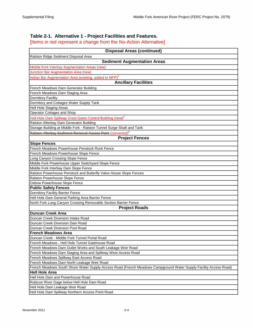
Disposal Areas (continued)Ralston Ridge Sediment Disposal Area
Sediment Augmentation AreasMiddle Fork Interbay Augmentation Areas (new)Junction Bar Augmentation Area (new)Indian Bar Augmentation Area (existing, added to MFP)4
Ancillary FacilitiesFrench Meadows Dam Generator BuildingFrench Meadows Dam Staging AreaDormitory FacilityDormitory and Cottages Water Supply TankHell Hole Staging Areas Operator Cottages and ShopHell Hole Dam Spillway Crest Gates Control Building (new)2
Ralston Afterbay Dam Generator BuildingStorage Building at Middle Fork - Ralston Tunnel Surge Shaft and TankRalston Afterbay Sediment Removal Access Point (converted)5
Project FencesSlope FencesFrench Meadows Powerhouse Penstock Rock FenceFrench Meadows Powerhouse Slope FenceLong Canyon Crossing Slope FenceMiddle Fork Powerhouse Upper Switchyard Slope FenceMiddle Fork Interbay Dam Slope FenceRalston Powerhouse Penstock and Butterfly Valve House Slope Fences Ralston Powerhouse Slope FenceOxbow Powerhouse Slope FencePublic Safety FencesDormitory Facility Barrier FenceHell Hole Dam General Parking Area Barrier FenceNorth Fork Long Canyon Crossing Removable Section Barrier Fence
Project RoadsDuncan Creek AreaDuncan Creek Diversion Intake RoadDuncan Creek Diversion Dam RoadDuncan Creek Diversion Pool RoadFrench Meadows AreaDuncan Creek - Middle Fork Tunnel Portal Road French Meadows - Hell Hole Tunnel Gatehouse RoadFrench Meadows Dam Outlet Works and South Leakage Weir RoadFrench Meadows Dam Staging Area and Spillway West Access RoadFrench Meadows Spillway East Access Road French Meadows Dam North Leakage Weir Road French Meadows South Shore Water Supply Access Road (French Meadows Campground Water Supply Facility Access Road)Hell Hole AreaHell Hole Dam and Powerhouse RoadRubicon River Gage below Hell Hole Dam RoadHell Hole Dam Leakage Weir RoadHell Hole Dam Spillway Northern Access Point Road
Supplemental Filing Middle Fork American River Project (FERC Project No. 2079)
November 2011 2-5
Table 2-1. Alternative 1 - Project Facilities and Features.[Items in red represent a change from the No-Action Alternative]
Project Roads (continued)Hell Hole Area (continued)French Meadows - Hell Hole Tunnel Portal RoadFrench Meadows Powerhouse RoadHell Hole - Middle Fork Tunnel Gatehouse RoadDormitory Facility RoadOperator Cottages and Shop RoadSpur on North Side of Operator CottageSpur on South Side of Operator Cottage Hell Hole Dam Spillway Discharge Channel Road Spur to Communication Line/PowerlineHell Hole Dam Spillway Discharge Channel RoadBig Meadows Campground Water Supply Facility Access Road Hell Hole Dam Spillway Gates Road (new)2
Long Canyon AreaNorth Fork Long Canyon Diversion North RoadNorth Fork Long Canyon Diversion South RoadNorth Fork Long Canyon Diversion Drop Inlet RoadSouth Fork Long Canyon Diversion and Drop Inlet RoadSouth Fork Long Canyon Diversion and Drop Inlet Cutoff RoadSouth Fork Long Canyon Diversion Drop Inlet Access RoadNorth Fork Long Canyon Crossing Removable Section North RoadNorth Fork Long Canyon Crossing Removable Section South RoadMiddle Meadows Group Campground Water Supply Facility Access RoadMiddle Fork Interbay AreaMiddle Fork Interbay Dam RoadMiddle Fork Interbay Dam to Powerhouse RoadMiddle Fork Powerhouse Butterfly Valve House RoadMiddle Fork Powerhouse Penstock and Butterfly Valve House Road Middle Fork Powerhouse Upper Switchyard RoadRalston - Oxbow AreaBrushy Canyon Adit RoadRalston Powerhouse Butterfly Valve House RoadRalston Afterbay Dam Access RoadIndian Bar Access RoadOxbow Powerhouse RoadRalston - Oxbow Tunnel Intake RoadRalston Afterbay Private Boat Ramp Road Ralston Afterbay Dam and Access Point Road
Project TrailsDuncan Creek AreaDuncan Creek Diversion Dam North TrailDuncan Creek Diversion Dam South TrailPhotovoltaic Poles and Powerline at Duncan Creek Gage near French Meadows TrailDuncan Creek Gage and Weir near French Meadows TrailDuncan Creek Gage below Diversion Dam Access TrailFrench Meadows AreaPoppy Trail (existing, added to MFP)3
French Meadows Reservoir Trail (new)2
Supplemental Filing Middle Fork American River Project (FERC Project No. 2079)
November 2011 2-6
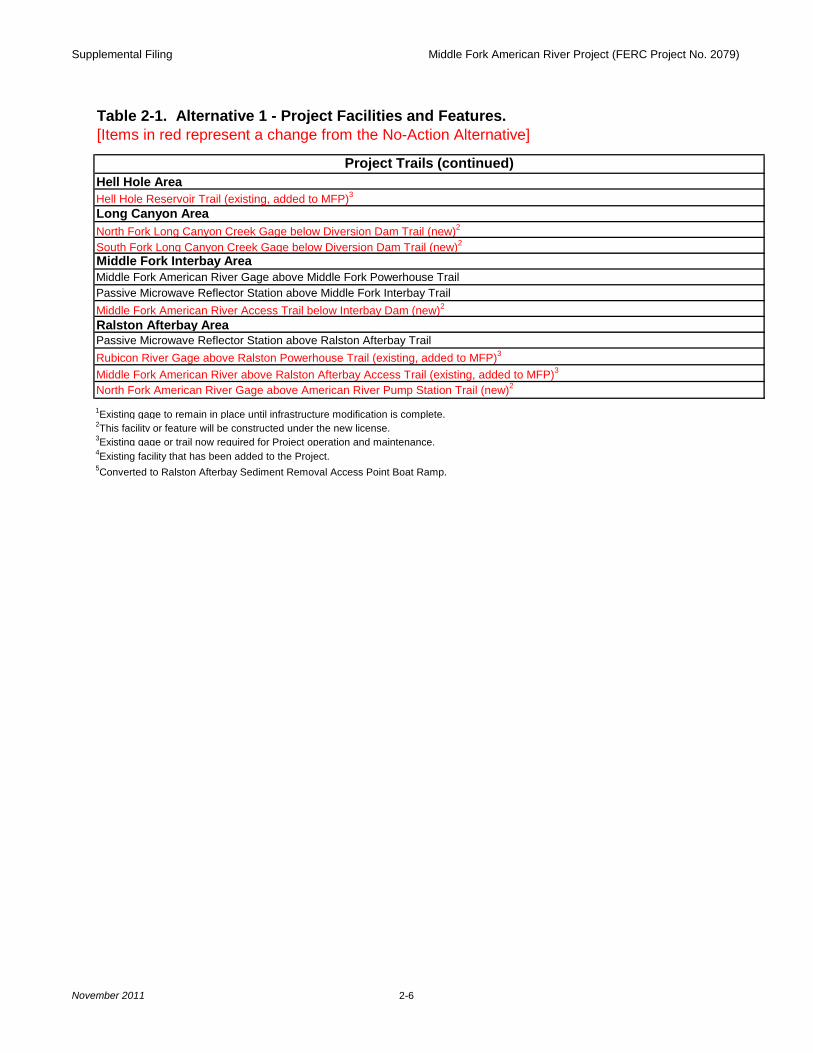
Table 2-1. Alternative 1 - Project Facilities and Features.[Items in red represent a change from the No-Action Alternative]
Project Trails (continued)Hell Hole AreaHell Hole Reservoir Trail (existing, added to MFP)3
Long Canyon AreaNorth Fork Long Canyon Creek Gage below Diversion Dam Trail (new)2
South Fork Long Canyon Creek Gage below Diversion Dam Trail (new)2
Middle Fork Interbay AreaMiddle Fork American River Gage above Middle Fork Powerhouse TrailPassive Microwave Reflector Station above Middle Fork Interbay TrailMiddle Fork American River Access Trail below Interbay Dam (new)2
Ralston Afterbay AreaPassive Microwave Reflector Station above Ralston Afterbay TrailRubicon River Gage above Ralston Powerhouse Trail (existing, added to MFP)3
Middle Fork American River above Ralston Afterbay Access Trail (existing, added to MFP)3
North Fork American River Gage above American River Pump Station Trail (new)2
1Existing gage to remain in place until infrastructure modification is complete. 2This facility or feature will be constructed under the new license.3Existing gage or trail now required for Project operation and maintenance.4Existing facility that has been added to the Project.5Converted to Ralston Afterbay Sediment Removal Access Point Boat Ramp.
Supplemental Filing Middle Fork American River Project (FERC Project No. 2079)
November 2011 2-7
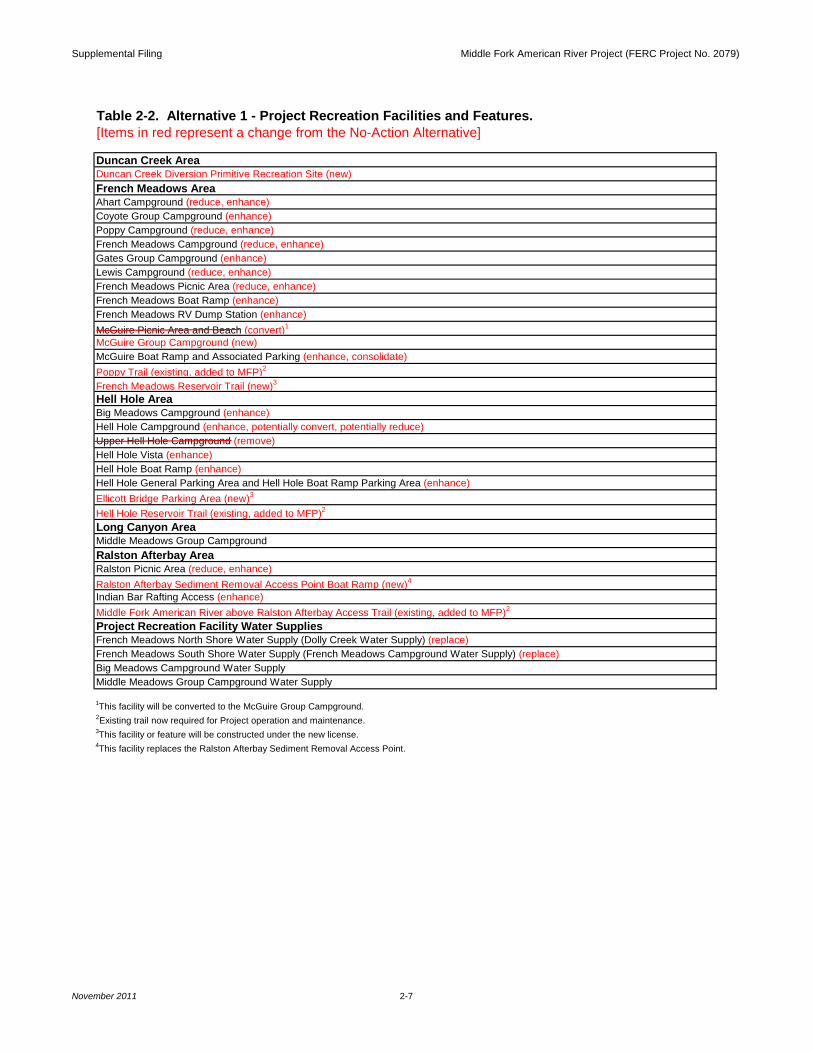
Table 2-2. Alternative 1 - Project Recreation Facilities and Features. [Items in red represent a change from the No-Action Alternative]
Duncan Creek AreaDuncan Creek Diversion Primitive Recreation Site (new)French Meadows AreaAhart Campground (reduce, enhance)Coyote Group Campground (enhance)Poppy Campground (reduce, enhance)French Meadows Campground (reduce, enhance)Gates Group Campground (enhance)Lewis Campground (reduce, enhance)French Meadows Picnic Area (reduce, enhance)French Meadows Boat Ramp (enhance)French Meadows RV Dump Station (enhance)McGuire Picnic Area and Beach (convert)1
McGuire Group Campground (new)McGuire Boat Ramp and Associated Parking (enhance, consolidate)Poppy Trail (existing, added to MFP)2
French Meadows Reservoir Trail (new)3
Hell Hole AreaBig Meadows Campground (enhance)Hell Hole Campground (enhance, potentially convert, potentially reduce)Upper Hell Hole Campground (remove)Hell Hole Vista (enhance)Hell Hole Boat Ramp (enhance)Hell Hole General Parking Area and Hell Hole Boat Ramp Parking Area (enhance)Ellicott Bridge Parking Area (new)3
Hell Hole Reservoir Trail (existing, added to MFP)2
Long Canyon AreaMiddle Meadows Group CampgroundRalston Afterbay AreaRalston Picnic Area (reduce, enhance)Ralston Afterbay Sediment Removal Access Point Boat Ramp (new)4
Indian Bar Rafting Access (enhance)Middle Fork American River above Ralston Afterbay Access Trail (existing, added to MFP)2
Project Recreation Facility Water SuppliesFrench Meadows North Shore Water Supply (Dolly Creek Water Supply) (replace)French Meadows South Shore Water Supply (French Meadows Campground Water Supply) (replace)Big Meadows Campground Water SupplyMiddle Meadows Group Campground Water Supply
1This facility will be converted to the McGuire Group Campground.2Existing trail now required for Project operation and maintenance.3This facility or feature will be constructed under the new license.4This facility replaces the Ralston Afterbay Sediment Removal Access Point.
Supplemental Filing Middle Fork American River Project (FERC Project No. 2079)
November 2011 2-8
Project Facility or Feature [Items in red represent a change from the No-
Action Alternative]
Tun
nel a
nd P
ower
hous
e In
spec
tion,
Testi
ng, a
nd M
ainten
ance
Spil
lway
& T
ainter
Gate
Tes
ting
Trim
ming
by H
and
Trim
ming
w/E
quipm
ent
Her
bicide
Use
Nox
ious W
eed M
anag
emen
t1
Phy
sical
Rode
nt Co
ntrol
(snap
trap
s)
Ove
r-the
-Cou
nter R
oden
ticide
Use
Rod
entic
ide U
se -
Fumi
gants
Phys
ical R
emov
al w/
Equip
ment
Inter
im S
edim
ent M
gmt.
Con
tinge
ncy S
edim
ent M
gmt.
Phy
sical
Remo
val w
/Equ
ipmen
t
Sed
imen
t Aug
menta
tion
Sed
imen
t Disp
osal
Gun
ite (e
rosio
n con
trol)
Roc
k Rem
oval/
Fenc
e Rep
air
Larg
e Woo
dy D
ebris
Clea
ning T
rash
Rac
ks
Log B
ooms
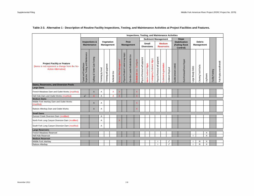
French Meadows Dam and Outlet Works (modified) A A A X X
Hell Hole Dam and Outlet Works (modified) A2 A A A X X
Middle Fork Interbay Dam and Outlet Works (modified) A A X
Ralston Afterbay Dam and Outlet Works A A X
Duncan Creek Diversion Dam (modified) A
North Fork Long Canyon Diversion Dam (modified) A X
South Fork Long Canyon Diversion Dam (modified) A
French Meadows Reservoir XHell Hole Reservoir I X
Middle Fork Interbay I I3 I R XRalston Afterbay I I3 I R X
Large Reservoirs
Inspections &Maintenance
VegetationManagement
Sediment Management
Small Diversions
Inspections, Testing, and Maintenance Activities
Large DamsDams, Reservoirs, and Diversion Pools
Table 2-3. Alternative 1 - Description of Routine Facility Inspections, Testing, and Maintenance Activities at Project Facilities and Features.
SlopeStabilization(Falling Rock
Control)
DebrisManagementMedium
Reservoirs
Pest Management
Fac
ility P
aintin
g
Pole
Rep
lacem
ent/R
etrofi
t
Small Dams
Medium Dams
Medium Reservoir
Supplemental Filing Middle Fork American River Project (FERC Project No. 2079)
November 2011 2-9
Project Facility or Feature [Items in red represent a change from the No-
Action Alternative]
Tun
nel a
nd P
ower
hous
e In
spec
tion,
Testi
ng, a
nd M
ainten
ance
Spil
lway
& T
ainter
Gate
Tes
ting
Trim
ming
by H
and
Trim
ming
w/E
quipm
ent
Her
bicide
Use
Nox
ious W
eed M
anag
emen
t1
Phy
sical
Rode
nt Co
ntrol
(snap
trap
s)
Ove
r-the
-Cou
nter R
oden
ticide
Use
Rod
entic
ide U
se -
Fumi
gants
Phys
ical R
emov
al w/
Equip
ment
Inter
im S
edim
ent M
gmt.
Con
tinge
ncy S
edim
ent M
gmt.
Phy
sical
Remo
val w
/Equ
ipmen
t
Sed
imen
t Aug
menta
tion
Sed
imen
t Disp
osal
Gun
ite (e
rosio
n con
trol)
Roc
k Rem
oval/
Fenc
e Rep
air
Larg
e Woo
dy D
ebris
Clea
ning T
rash
Rac
ks
Log B
ooms
Duncan Creek Diversion PoolPre-modification of diversion dam A I I R XPost modification of diversion dam A I
North Fork Long Canyon Diversion PoolPre-modification of diversion dam A X I I RPost modification of diversion dam A X I
South Fork Long Canyon Diversion PoolPre-modification of diversion dam A X I I RPost modification of diversion dam A X I
Duncan Creek - Middle Fork TunnelFrench Meadows - Hell Hole TunnelHell Hole - Middle Fork TunnelMiddle Fork - Ralston TunnelRalston - Oxbow Tunnel A
North Fork Long Canyon Diversion Pipe and Drop Inlet A
South Fork Long Canyon Diversion Pipe and Drop Inlet A
VegetationManagement
Pest Management
Sediment Management SlopeStabilization(Falling Rock
Control)
Small Diversion Pools
Water Conveyance Systems
Inspections, Testing, and Maintenance Activities
DebrisManagement
Fac
ility P
aintin
g
Small Diversions
MediumReservoirs
Tunnels
Diversion Pipes and Drop Inlets
Dams, Reservoirs, and Diversion Pools (continued)
Pole
Rep
lacem
ent/R
etrofi
t
Inspections &Maintenance
Table 2-3. Alternative 1 - Description of Routine Facility Inspections, Testing, and Maintenance Activities at Project Facilities and Features.
Supplemental Filing Middle Fork American River Project (FERC Project No. 2079)
November 2011 2-10
Project Facility or Feature [Items in red represent a change from the No-
Action Alternative]
Tun
nel a
nd P
ower
hous
e In
spec
tion,
Testi
ng, a
nd M
ainten
ance
Spil
lway
& T
ainter
Gate
Tes
ting
Trim
ming
by H
and
Trim
ming
w/E
quipm
ent
Her
bicide
Use
Nox
ious W
eed M
anag
emen
t1
Phy
sical
Rode
nt Co
ntrol
(snap
trap
s)
Ove
r-the
-Cou
nter R
oden
ticide
Use
Rod
entic
ide U
se -
Fumi
gants
Phys
ical R
emov
al w/
Equip
ment
Inter
im S
edim
ent M
gmt.
Con
tinge
ncy S
edim
ent M
gmt.
Phy
sical
Remo
val w
/Equ
ipmen
t
Sed
imen
t Aug
menta
tion
Sed
imen
t Disp
osal
Gun
ite (e
rosio
n con
trol)
Roc
k Rem
oval/
Fenc
e Rep
air
Larg
e Woo
dy D
ebris
Clea
ning T
rash
Rac
ks
Log B
ooms
Brushy Canyon Adit A X
Hell Hole - Middle Fork Tunnel Surge Shaft and Tank A I
Middle Fork - Ralston Tunnel Surge Shaft and Tank A X I
Duncan Creek - Middle Fork Tunnel Portal A IFrench Meadows - Hell Hole Tunnel Removable Section A I
Hell Hole - Middle Fork Tunnel Removable Section A X I
Middle Fork - Ralston Tunnel Removable Section A INorth Fork Long Canyon Crossing Removable Section A X I
Duncan Creek - Middle Fork Tunnel Intake AFrench Meadows - Hell Hole Tunnel Gatehouse AFrench Meadows - Hell Hole Tunnel Intake AHell Hole - Middle Fork Tunnel Gatehouse AHell Hole - Middle Fork Tunnel Intake A
Middle Fork - Ralston Tunnel Intake and Gatehouse A X
Ralston - Oxbow Tunnel Intake A X
DebrisManagement
Fac
ility P
aintin
g
MediumReservoirs
SlopeStabilization(Falling Rock
Control)
Inspections &Maintenance
VegetationManagement
Pest Management
Sediment Management
Pole
Rep
lacem
ent/R
etrofi
t
Inspections, Testing, and Maintenance Activities
Small Diversions
Water Conveyance Systems (continued)Surge Shafts and Adits
Table 2-3. Alternative 1 - Description of Routine Facility Inspections, Testing, and Maintenance Activities at Project Facilities and Features.
Removable Sections and Portals
Intakes and Gatehouses
Supplemental Filing Middle Fork American River Project (FERC Project No. 2079)
November 2011 2-11
Project Facility or Feature [Items in red represent a change from the No-
Action Alternative]
Tun
nel a
nd P
ower
hous
e In
spec
tion,
Testi
ng, a
nd M
ainten
ance
Spil
lway
& T
ainter
Gate
Tes
ting
Trim
ming
by H
and
Trim
ming
w/E
quipm
ent
Her
bicide
Use
Nox
ious W
eed M
anag
emen
t1
Phy
sical
Rode
nt Co
ntrol
(snap
trap
s)
Ove
r-the
-Cou
nter R
oden
ticide
Use
Rod
entic
ide U
se -
Fumi
gants
Phys
ical R
emov
al w/
Equip
ment
Inter
im S
edim
ent M
gmt.
Con
tinge
ncy S
edim
ent M
gmt.
Phy
sical
Remo
val w
/Equ
ipmen
t
Sed
imen
t Aug
menta
tion
Sed
imen
t Disp
osal
Gun
ite (e
rosio
n con
trol)
Roc
k Rem
oval/
Fenc
e Rep
air
Larg
e Woo
dy D
ebris
Clea
ning T
rash
Rac
ks
Log B
ooms
French Meadows Powerhouse Penstock and Butterfly Valve House A A I
Middle Fork Powerhouse Penstock and Butterfly Valve House A A X I I
Ralston Powerhouse Penstock and Butterfly Valve House A A I
French Meadows Powerhouse and Switchyard A A A X X XHell Hole Powerhouse A A X X XHell Hole Substation A X X XMiddle Fork Powerhouse and Upper and Lower Switchyards A A A X X X
Ralston Powerhouse and Switchyard A A A X X XOxbow Powerhouse and Switchyard A A A X X X
Duncan Creek near French Meadows (USGS Gage No. 11427700) (interim)4 A
Duncan Creek below Diversion Dam (USGS Gage No. 11427750) A
Middle Fork American River at French Meadows (USGS Gage No. 11427500) A
Small Diversions
MediumReservoirs
Inspections, Testing, and Maintenance Activities
Inspections &Maintenance
VegetationManagement
Pest Management
Sediment Management
Fac
ility P
aintin
g
Pole
Rep
lacem
ent/R
etrofi
t
Water Conveyance Systems (continued)Penstocks and Valve Houses
SlopeStabilization(Falling Rock
Control)
DebrisManagement
Stream Gages and Weirs
Table 2-3. Alternative 1 - Description of Routine Facility Inspections, Testing, and Maintenance Activities at Project Facilities and Features.
Powerhouses, Switchyards, and Substations
Gaging Stations and Weirs
Supplemental Filing Middle Fork American River Project (FERC Project No. 2079)
November 2011 2-12
Project Facility or Feature [Items in red represent a change from the No-
Action Alternative]
Tun
nel a
nd P
ower
hous
e In
spec
tion,
Testi
ng, a
nd M
ainten
ance
Spil
lway
& T
ainter
Gate
Tes
ting
Trim
ming
by H
and
Trim
ming
w/E
quipm
ent
Her
bicide
Use
Nox
ious W
eed M
anag
emen
t1
Phy
sical
Rode
nt Co
ntrol
(snap
trap
s)
Ove
r-the
-Cou
nter R
oden
ticide
Use
Rod
entic
ide U
se -
Fumi
gants
Phys
ical R
emov
al w/
Equip
ment
Inter
im S
edim
ent M
gmt.
Con
tinge
ncy S
edim
ent M
gmt.
Phy
sical
Remo
val w
/Equ
ipmen
t
Sed
imen
t Aug
menta
tion
Sed
imen
t Disp
osal
Gun
ite (e
rosio
n con
trol)
Roc
k Rem
oval/
Fenc
e Rep
air
Larg
e Woo
dy D
ebris
Clea
ning T
rash
Rac
ks
Log B
ooms
Middle Fork American River at French Meadows Dam (new)5 X
Rubicon River at Hell Hole Dam Spillway (HHDS) (new)5
Rubicon River below Hell Hole Dam (USGS Gage No. 11428800) (interim)4 A
Rubicon River at Hell Hole Dam (new)5
North Fork Long Canyon Creek below Diversion Dam (USGS Gage No. 11433085) (interim)4 A X
North Fork Long Canyon Creek below Diversion Dam (NFLCC) (new)5 A X
South Fork Long Canyon Creek below Diversion Dam (USGS Gage No. 11433065) (interim)4 A
South Fork Long Canyon Creek below Diversion Dam (SFLCC) (new)5 A
Middle Fork American River below Interbay Dam (USGS Gage No. 11427770) (interim)4 A X
Middle Fork American River above Middle Fork Powerhouse (USGS Gage No. 11427760) A X
Small Diversions
MediumReservoirs
Inspections, Testing, and Maintenance Activities
Inspections &Maintenance
VegetationManagement
Pest Management
Sediment Management SlopeStabilization(Falling Rock
Control)
DebrisManagement
Fac
ility P
aintin
g
Pole
Rep
lacem
ent/R
etrofi
t
Gaging Stations and Weirs (continued)Stream Gages and Weirs (continued)
Table 2-3. Alternative 1 - Description of Routine Facility Inspections, Testing, and Maintenance Activities at Project Facilities and Features.
Supplemental Filing Middle Fork American River Project (FERC Project No. 2079)
November 2011 2-13
Project Facility or Feature [Items in red represent a change from the No-
Action Alternative]
Tun
nel a
nd P
ower
hous
e In
spec
tion,
Testi
ng, a
nd M
ainten
ance
Spil
lway
& T
ainter
Gate
Tes
ting
Trim
ming
by H
and
Trim
ming
w/E
quipm
ent
Her
bicide
Use
Nox
ious W
eed M
anag
emen
t1
Phy
sical
Rode
nt Co
ntrol
(snap
trap
s)
Ove
r-the
-Cou
nter R
oden
ticide
Use
Rod
entic
ide U
se -
Fumi
gants
Phys
ical R
emov
al w/
Equip
ment
Inter
im S
edim
ent M
gmt.
Con
tinge
ncy S
edim
ent M
gmt.
Phy
sical
Remo
val w
/Equ
ipmen
t
Sed
imen
t Aug
menta
tion
Sed
imen
t Disp
osal
Gun
ite (e
rosio
n con
trol)
Roc
k Rem
oval/
Fenc
e Rep
air
Larg
e Woo
dy D
ebris
Clea
ning T
rash
Rac
ks
Log B
ooms
Middle Fork American River below Interbay Dam (MFARIB) (new)5 A X
Middle Fork American River near Foresthill (USGS Gage No. 11433300) A
Middle Fork American River at Ralston Afterbay Dam (new)5 A X
Rubicon River above Ralston Powerhouse (RRRP) (existing, added to MFP)6 A X
North Fork American River above American River Pump Station (NFARPS) (new)5 A X
Rubicon River above Ellicott Bridge (RREB) (existing, added to MFP)6 A X
Duncan Creek Diversion Tunnel (DCDT) (new)5
North Fork Long Canyon Creek Diversion Tunnel (USGS Gage No. 11433080) (modified) X
South Fork Long Canyon Creek Diversion Tunnel (USGS Gage No. 11433060) (modified)
French Meadows Reservoir (USGS Gage No. 11427400)
Inspections, Testing, and Maintenance Activities
Inspections &Maintenance
VegetationManagement
Pest Management
Sediment Management SlopeStabilization(Falling Rock
Control)
DebrisManagement
Fac
ility P
aintin
g
Small Diversions
MediumReservoirs
Pole
Rep
lacem
ent/R
etrofi
t
Gaging Stations and Weirs (continued)
Table 2-3. Alternative 1 - Description of Routine Facility Inspections, Testing, and Maintenance Activities at Project Facilities and Features.
Stream Gages and Weirs (continued)
Reservoir Gages
Diversion Gages
Supplemental Filing Middle Fork American River Project (FERC Project No. 2079)
November 2011 2-14
Project Facility or Feature [Items in red represent a change from the No-
Action Alternative]
Tun
nel a
nd P
ower
hous
e In
spec
tion,
Testi
ng, a
nd M
ainten
ance
Spil
lway
& T
ainter
Gate
Tes
ting
Trim
ming
by H
and
Trim
ming
w/E
quipm
ent
Her
bicide
Use
Nox
ious W
eed M
anag
emen
t1
Phy
sical
Rode
nt Co
ntrol
(snap
trap
s)
Ove
r-the
-Cou
nter R
oden
ticide
Use
Rod
entic
ide U
se -
Fumi
gants
Phys
ical R
emov
al w/
Equip
ment
Inter
im S
edim
ent M
gmt.
Con
tinge
ncy S
edim
ent M
gmt.
Phy
sical
Remo
val w
/Equ
ipmen
t
Sed
imen
t Aug
menta
tion
Sed
imen
t Disp
osal
Gun
ite (e
rosio
n con
trol)
Roc
k Rem
oval/
Fenc
e Rep
air
Larg
e Woo
dy D
ebris
Clea
ning T
rash
Rac
ks
Log B
ooms
French Meadows Reservoir Staff Gage X
Hell Hole Reservoir (USGS Gage No. 11428700)
Hell Hole Reservoir Staff GageMiddle Fork Interbay Reservoir XRalston Afterbay Reservoir
French Meadows Powerhouse (USGS Gage No. 11427200) X
Middle Fork Powerhouse (USGS Gage No. 11428600) X
Ralston Powerhouse (USGS Gage No. 11427765) X
Oxbow Powerhouse (USGS Gage No. 11433212) X
Oxbow Powerhouse Penstock (OXBPP) (new)5 X
French Meadows Dam Leakage Weirs Nos. 1-6 AHell Hole Dam Leakage Weir A X
Small Diversions
Sediment Management SlopeStabilization(Falling Rock
Control)
DebrisManagement
Gaging Stations and Weirs (continued)Reservoir Gages (continued)
Powerhouse Gages
Leakage Weirs
MediumReservoirs
Inspections, Testing, and Maintenance Activities
Inspections &Maintenance
Fac
ility P
aintin
g
VegetationManagement
Pest Management
Pole
Rep
lacem
ent/R
etrofi
t
Table 2-3. Alternative 1 - Description of Routine Facility Inspections, Testing, and Maintenance Activities at Project Facilities and Features.
Supplemental Filing Middle Fork American River Project (FERC Project No. 2079)
November 2011 2-15
Project Facility or Feature [Items in red represent a change from the No-
Action Alternative]
Tun
nel a
nd P
ower
hous
e In
spec
tion,
Testi
ng, a
nd M
ainten
ance
Spil
lway
& T
ainter
Gate
Tes
ting
Trim
ming
by H
and
Trim
ming
w/E
quipm
ent
Her
bicide
Use
Nox
ious W
eed M
anag
emen
t1
Phy
sical
Rode
nt Co
ntrol
(snap
trap
s)
Ove
r-the
-Cou
nter R
oden
ticide
Use
Rod
entic
ide U
se -
Fumi
gants
Phys
ical R
emov
al w/
Equip
ment
Inter
im S
edim
ent M
gmt.
Con
tinge
ncy S
edim
ent M
gmt.
Phy
sical
Remo
val w
/Equ
ipmen
t
Sed
imen
t Aug
menta
tion
Sed
imen
t Disp
osal
Gun
ite (e
rosio
n con
trol)
Roc
k Rem
oval/
Fenc
e Rep
air
Larg
e Woo
dy D
ebris
Clea
ning T
rash
Rac
ks
Log B
ooms
French Meadows Dam Generator Building to French Meadows Dam Outlet Works Powerline A X S
French Meadows Dam Generator Building to French Meadows Dam Spillway Gates Powerline A S
French Meadows Powerhouse to French Meadows Powerhouse Penstock and Butterfly Valve House Communication Line/Powerline
A A S
French Meadows Powerhouse and Switchyard to Hell Hole - Middle Fork Tunnel Gatehouse, Dormitory Facility, Operator’s Cottages, and Hell Hole Powerhouse Communication Line/Powerline
A S
Dormitory and Cottages Water Supply Tank Powerline A S
Hell Hole Powerhouse to Rubicon River Gage below Hell Hole Dam Communication Line/Powerline A X S
Hell Hole Dam Spillway Crest Gates Control Building Communication Line/Powerline (new)5
Middle Fork Powerhouse to Middle Fork Powerhouse Butterfly Valve House Communication Line/Powerline A A S
Inspections, Testing, and Maintenance Activities
Inspections &Maintenance
VegetationManagement
Pest Management
Sediment Management SlopeStabilization(Falling Rock
Control)
Small Diversions
MediumReservoirs
DebrisManagement
Fac
ility P
aintin
g
Pole
Rep
lacem
ent/R
etrofi
t
Project Communication Lines and Powerlines French Meadows Area
Hell Hole Area
Middle Fork Interbay Area
Table 2-3. Alternative 1 - Description of Routine Facility Inspections, Testing, and Maintenance Activities at Project Facilities and Features.
Supplemental Filing Middle Fork American River Project (FERC Project No. 2079)
November 2011 2-16
Project Facility or Feature [Items in red represent a change from the No-
Action Alternative]
Tun
nel a
nd P
ower
hous
e In
spec
tion,
Testi
ng, a
nd M
ainten
ance
Spil
lway
& T
ainter
Gate
Tes
ting
Trim
ming
by H
and
Trim
ming
w/E
quipm
ent
Her
bicide
Use
Nox
ious W
eed M
anag
emen
t1
Phy
sical
Rode
nt Co
ntrol
(snap
trap
s)
Ove
r-the
-Cou
nter R
oden
ticide
Use
Rod
entic
ide U
se -
Fumi
gants
Phys
ical R
emov
al w/
Equip
ment
Inter
im S
edim
ent M
gmt.
Con
tinge
ncy S
edim
ent M
gmt.
Phy
sical
Remo
val w
/Equ
ipmen
t
Sed
imen
t Aug
menta
tion
Sed
imen
t Disp
osal
Gun
ite (e
rosio
n con
trol)
Roc
k Rem
oval/
Fenc
e Rep
air
Larg
e Woo
dy D
ebris
Clea
ning T
rash
Rac
ks
Log B
ooms
Middle Fork Powerhouse Butterfly Valve House to Radio Repeater near Hell Hole - Middle Fork Tunnel Surge Tank (underground) Communication Line/Powerline
A X S
Middle Fork Powerhouse to Middle Fork - Ralston Tunnel Intake and Gatehouse Communication Line/Powerline
A X S
Middle Fork Powerhouse to Middle Fork American River Gage above Middle Fork Powerhouse Communication Line/Powerline
A X S
Ralston - Oxbow Tunnel Intake to Ralston Powerhouse Communication Line A X S
Ralston Powerhouse to Ralston Powerhouse Butterfly Valve House Communication Line/Powerline A A X S
Ralston Afterbay Dam Generator Building to Ralston - Oxbow Tunnel Intake Communication Line/Powerline A X S
Oxbow Powerhouse to Ralston Afterbay Dam Generator Building Communication Line/Powerline A X S
Photovoltaic Poles and Powerline at Duncan Creek Gage near French Meadows A
Pest Management
Fac
ility P
aintin
g
Small Diversions
SlopeStabilization(Falling Rock
Control)
DebrisManagementMedium
Reservoirs
Pole
Rep
lacem
ent/R
etrofi
t
Inspections, Testing, and Maintenance Activities
Inspections &Maintenance
VegetationManagement
Sediment Management
Project Communication Lines and Powerlines (continued)
Table 2-3. Alternative 1 - Description of Routine Facility Inspections, Testing, and Maintenance Activities at Project Facilities and Features.
Middle Fork Interbay Area (continued)
Ralston - Oxbow Area
Photovoltaic Poles and Powerlines
Supplemental Filing Middle Fork American River Project (FERC Project No. 2079)
November 2011 2-17
Project Facility or Feature [Items in red represent a change from the No-
Action Alternative]
Tun
nel a
nd P
ower
hous
e In
spec
tion,
Testi
ng, a
nd M
ainten
ance
Spil
lway
& T
ainter
Gate
Tes
ting
Trim
ming
by H
and
Trim
ming
w/E
quipm
ent
Her
bicide
Use
Nox
ious W
eed M
anag
emen
t1
Phy
sical
Rode
nt Co
ntrol
(snap
trap
s)
Ove
r-the
-Cou
nter R
oden
ticide
Use
Rod
entic
ide U
se -
Fumi
gants
Phys
ical R
emov
al w/
Equip
ment
Inter
im S
edim
ent M
gmt.
Con
tinge
ncy S
edim
ent M
gmt.
Phy
sical
Remo
val w
/Equ
ipmen
t
Sed
imen
t Aug
menta
tion
Sed
imen
t Disp
osal
Gun
ite (e
rosio
n con
trol)
Roc
k Rem
oval/
Fenc
e Rep
air
Larg
e Woo
dy D
ebris
Clea
ning T
rash
Rac
ks
Log B
ooms
Photovoltaic Pole and Powerline at Duncan Creek Gage below Diversion Dam A
Photovoltaic Pole and Powerline at Duncan Creek Gage at Diversion Tunnel (new)5 A X
Photovoltaic Pole and Powerline at Middle Fork American River Gage at French Meadows A X
Photovoltaic Pole and Powerline at Middle Fork American River Gage above Middle Fork Powerhouse
A
Photovoltaic Pole and Powerline at Middle Fork American River Gage below Interbay Dam (new)5 A X
Photovoltaic Pole and Powerline at North Fork Long Canyon Creek Gage below Diversion Dam A
Photovoltaic Pole and Powerline at North Fork Long Canyon Creek Gage below Diversion Dam (new)5 A X
Photovoltaic Pole and Powerline at South Fork Long Canyon Creek Gage below Diversion Dam A
Photovoltaic Pole and Powerline at South Fork Long Canyon Creek Gage below Diversion Dam (new)5 A
Photovoltaic Pole and Powerline at Rubicon River Gage above Ralston Powerhouse (existing, added to MFP)7
A
SlopeStabilization(Falling Rock
Control)
DebrisManagement
Fac
ility P
aintin
g
Pole
Rep
lacem
ent/R
etrofi
t
Small Diversions
MediumReservoirs
Inspections, Testing, and Maintenance Activities
Photovoltaic Poles and Powerlines (continued)
Inspections &Maintenance
VegetationManagement
Pest Management
Sediment Management
Table 2-3. Alternative 1 - Description of Routine Facility Inspections, Testing, and Maintenance Activities at Project Facilities and Features.
Project Communication Lines and Powerlines (continued)
Supplemental Filing Middle Fork American River Project (FERC Project No. 2079)
November 2011 2-18
Project Facility or Feature [Items in red represent a change from the No-
Action Alternative]
Tun
nel a
nd P
ower
hous
e In
spec
tion,
Testi
ng, a
nd M
ainten
ance
Spil
lway
& T
ainter
Gate
Tes
ting
Trim
ming
by H
and
Trim
ming
w/E
quipm
ent
Her
bicide
Use
Nox
ious W
eed M
anag
emen
t1
Phy
sical
Rode
nt Co
ntrol
(snap
trap
s)
Ove
r-the
-Cou
nter R
oden
ticide
Use
Rod
entic
ide U
se -
Fumi
gants
Phys
ical R
emov
al w/
Equip
ment
Inter
im S
edim
ent M
gmt.
Con
tinge
ncy S
edim
ent M
gmt.
Phy
sical
Remo
val w
/Equ
ipmen
t
Sed
imen
t Aug
menta
tion
Sed
imen
t Disp
osal
Gun
ite (e
rosio
n con
trol)
Roc
k Rem
oval/
Fenc
e Rep
air
Larg
e Woo
dy D
ebris
Clea
ning T
rash
Rac
ks
Log B
ooms
Photovoltaic Pole and Powerline at Middle Fork American River Gage near Foresthill A
Photovoltaic Pole and Powerline at North Fork American River Gage above American River Pump Station (new)5
A X
Photovoltaic Pole and Powerline at Rubicon River Gage above Ellicott Bridge (existing, added to MFP)7
A X
Passive Microwave Reflector Station above Middle Fork Interbay I
Radio Communications Tower near French Meadows - Hell Hole Tunnel Gatehouse I
Radio Communications Tower and Repeater near Hell Hole - Middle Fork Tunnel Surge Shaft and Tank I
Passive Microwave Reflector Station above Ralston Afterbay I X
Duncan Creek Diversion Sediment Disposal Area
North Fork Long Canyon Crossing Sediment Disposal Area X
Middle Fork Interbay Sediment Disposal Area XRalston Ridge Sediment Disposal Area X
Pest Management
Sediment Management
Photovoltaic Poles and Powerlines (continued)
Microwave Reflectors and Radio Towers
Disposal Areas
Fac
ility P
aintin
g
Pole
Rep
lacem
ent/R
etrofi
t
Small Diversions
MediumReservoirs
Inspections, Testing, and Maintenance Activities
Inspections &Maintenance
SlopeStabilization(Falling Rock
Control)
DebrisManagement
VegetationManagement
Project Communication Lines and Powerlines (continued)
Table 2-3. Alternative 1 - Description of Routine Facility Inspections, Testing, and Maintenance Activities at Project Facilities and Features.
Supplemental Filing Middle Fork American River Project (FERC Project No. 2079)
November 2011 2-19
Project Facility or Feature [Items in red represent a change from the No-
Action Alternative]
Tun
nel a
nd P
ower
hous
e In
spec
tion,
Testi
ng, a
nd M
ainten
ance
Spil
lway
& T
ainter
Gate
Tes
ting
Trim
ming
by H
and
Trim
ming
w/E
quipm
ent
Her
bicide
Use
Nox
ious W
eed M
anag
emen
t1
Phy
sical
Rode
nt Co
ntrol
(snap
trap
s)
Ove
r-the
-Cou
nter R
oden
ticide
Use
Rod
entic
ide U
se -
Fumi
gants
Phys
ical R
emov
al w/
Equip
ment
Inter
im S
edim
ent M
gmt.
Con
tinge
ncy S
edim
ent M
gmt.
Phy
sical
Remo
val w
/Equ
ipmen
t
Sed
imen
t Aug
menta
tion
Sed
imen
t Disp
osal
Gun
ite (e
rosio
n con
trol)
Roc
k Rem
oval/
Fenc
e Rep
air
Larg
e Woo
dy D
ebris
Clea
ning T
rash
Rac
ks
Log B
ooms
Middle Fork Interbay Augmentation Areas (new) I3
Junction Bar Augmentation Area (new) A X I3
Indian Bar Augmentation Area (existing, added to MFP)7 A X I3
French Meadows Dam Generator Building A A X X IFrench Meadows Dam Staging Area I XDormitory Facility A A X X IDormitory and Cottages Water Supply Tank A I X X IHell Hole Staging Areas AOperator Cottages and Shop A A X X X IHell Hole Dam Spillway Crest Gates Control Building (new)5 A X X
Ralston Afterbay Dam Generator Building A A X X X IStorage Building at Middle Fork - Ralston Tunnel Surge Shaft and Tank A A X
Ralston Afterbay Sediment Removal Access Point (converted)9
French Meadows Powerhouse Penstock Rock Fence A
French Meadows Powerhouse Slope Fence I X A
Sediment ManagementDebris
Management
Sediment Augmentation Areas
Slope Fences
Pest Management
SlopeStabilization(Falling Rock
Control)
Fac
ility P
aintin
g
Pole
Rep
lacem
ent/R
etrofi
t
Small Diversions
MediumReservoirs
Table 2-3. Alternative 1 - Description of Routine Facility Inspections, Testing, and Maintenance Activities at Project Facilities and Features.
VegetationManagement
Ancillary Facilities
Project Fences
Inspections, Testing, and Maintenance Activities
Inspections &Maintenance
Supplemental Filing Middle Fork American River Project (FERC Project No. 2079)
November 2011 2-20
Project Facility or Feature [Items in red represent a change from the No-
Action Alternative]
Tun
nel a
nd P
ower
hous
e In
spec
tion,
Testi
ng, a
nd M
ainten
ance
Spil
lway
& T
ainter
Gate
Tes
ting
Trim
ming
by H
and
Trim
ming
w/E
quipm
ent
Her
bicide
Use
Nox
ious W
eed M
anag
emen
t1
Phy
sical
Rode
nt Co
ntrol
(snap
trap
s)
Ove
r-the
-Cou
nter R
oden
ticide
Use
Rod
entic
ide U
se -
Fumi
gants
Phys
ical R
emov
al w/
Equip
ment
Inter
im S
edim
ent M
gmt.
Con
tinge
ncy S
edim
ent M
gmt.
Phy
sical
Remo
val w
/Equ
ipmen
t
Sed
imen
t Aug
menta
tion
Sed
imen
t Disp
osal
Gun
ite (e
rosio
n con
trol)
Roc
k Rem
oval/
Fenc
e Rep
air
Larg
e Woo
dy D
ebris
Clea
ning T
rash
Rac
ks
Log B
ooms
Long Canyon Crossing Slope Fence I AMiddle Fork Powerhouse Upper Switchyard Slope Fence I X A
Middle Fork Interbay Dam Slope Fence ARalston Powerhouse Penstock and Butterfly Valve House Slope Fences I X A
Ralston Powerhouse Slope Fence I X AOxbow Powerhouse Slope Fence I X A
Dormitory Facility Barrier Fence A
Hell Hole Dam General Parking Area Barrier Fence X A
North Fork Long Canyon Crossing Removable Section Barrier Fence X A
A = Activity occurs on an annual basis.I = Activity occurs on an infrequent basis. R = Completed as-needed during diversion season.S = Scheduled retrofit or replacement.X = Activity occurs or ancillary facility is present.
2Inspection of 1,000 feet of outlet conduit.
SlopeStabilization(Falling Rock
Control)
Inspections, Testing, and Maintenance Activities
Inspections &Maintenance
VegetationManagement
Pest Management
Sediment ManagementDebris
Management
Fac
ility P
aintin
g
Pole
Rep
lacem
ent/R
etrofi
t
Small Diversions
MediumReservoirs
Table 2-3. Alternative 1 - Description of Routine Facility Inspections, Testing, and Maintenance Activities at Project Facilities and Features.
5This facility or feature will be constructed under the new license.
1Indicates areas where manual and chemical treatment of target noxious weed populations will be implemented. Manual and chemical treatments may be completed at other locations during the term of the license if new target noxious weed populations are identified during inventory surveys.
4Existing gage to remain in place until infrastructure modification is complete.
3Sediment augmentation will be implemented at Middle Fork Interbay Augmentation Areas, Junction Bar Augmentation Area, and Indian Bar Augmentation Area; and sediment disposal will occur at Project sediment disposal areas or other agency-approved disposal areas.
6Existing gage or trail now required for Project operation and maintenance.7Existing facility that has been added to the Project.8Material excavated from medium reservoirs will be placed at this sediment augmentation area.9Converted to Ralston Afterbay Sediment Removal Access Point Boat Ramp. This facility is addressed under Project Recreation Facilities and Features.
Slope Fences
Public Safety Fences
Project Fences
Supplemental Filing Middle Fork American River Project (FERC Project No. 2079)
November 2011 2-21
Project Road or Trail[Items in red represent a change from the No-Action Alternative]
Trim
ming
by H
and
Trim
ming
w/E
quipm
ent
Herb
icide
Use
Noxio
us W
eed M
anag
emen
t2
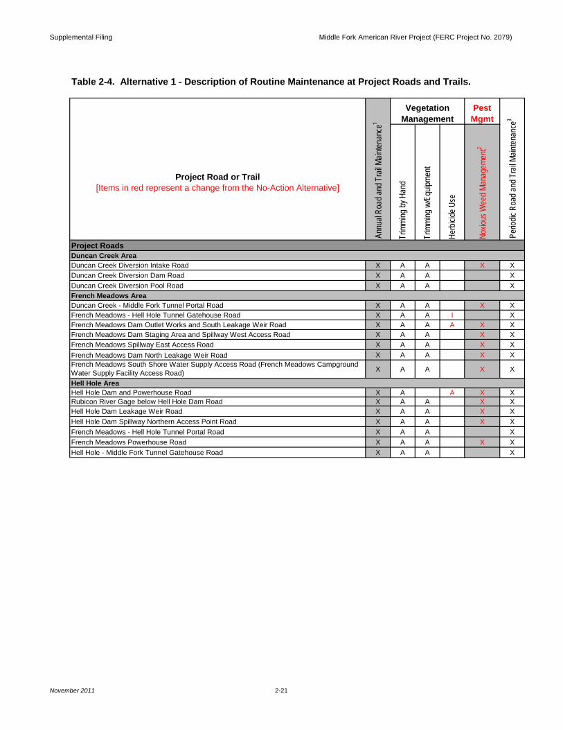
Duncan Creek Diversion Intake Road X A A X XDuncan Creek Diversion Dam Road X A A XDuncan Creek Diversion Pool Road X A A X
Duncan Creek - Middle Fork Tunnel Portal Road X A A X XFrench Meadows - Hell Hole Tunnel Gatehouse Road X A A I XFrench Meadows Dam Outlet Works and South Leakage Weir Road X A A A X XFrench Meadows Dam Staging Area and Spillway West Access Road X A A X XFrench Meadows Spillway East Access Road X A A X XFrench Meadows Dam North Leakage Weir Road X A A X XFrench Meadows South Shore Water Supply Access Road (French Meadows Campground Water Supply Facility Access Road) X A A X X
Hell Hole Dam and Powerhouse Road X A A X XRubicon River Gage below Hell Hole Dam Road X A A X XHell Hole Dam Leakage Weir Road X A A X XHell Hole Dam Spillway Northern Access Point Road X A A X XFrench Meadows - Hell Hole Tunnel Portal Road X A A XFrench Meadows Powerhouse Road X A A X XHell Hole - Middle Fork Tunnel Gatehouse Road X A A X
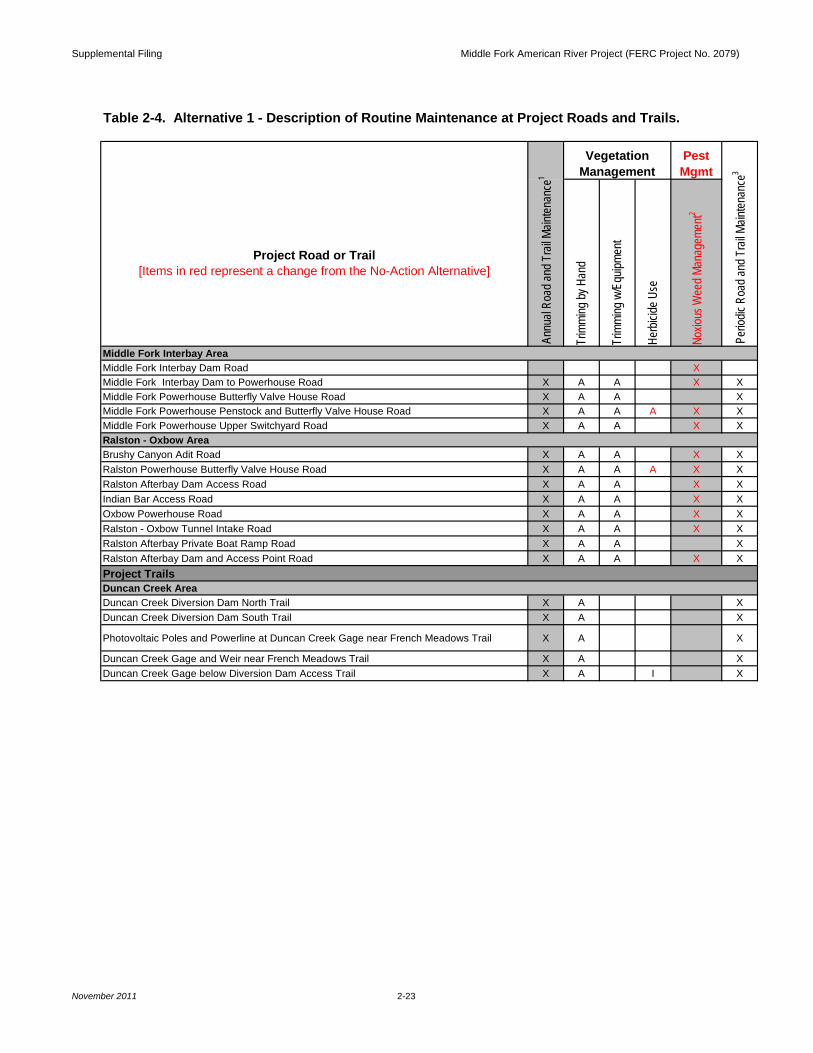
Table 2-4. Alternative 1 - Description of Routine Maintenance at Project Roads and Trails.
Project Roads
Perio
dic R
oad a
nd T
rail M
ainten
ance
3
Annu
al Ro
ad an
d Tra
il Main
tenan
ce1
VegetationManagement
Pest Mgmt
Duncan Creek Area
French Meadows Area
Hell Hole Area
Supplemental Filing Middle Fork American River Project (FERC Project No. 2079)
November 2011 2-22
Project Road or Trail[Items in red represent a change from the No-Action Alternative]
Trim
ming
by H
and
Trim
ming
w/E
quipm
ent
Herb
icide
Use
Noxio
us W
eed M
anag
emen
t2
Dormitory Facility Road X A A XOperator Cottages and Shop Road X A A XSpur on North Side of Operator Cottage X A A X XSpur on South Side of Operator Cottage X A A X X
Hell Hole Dam Spillway Discharge Channel Road Spur to Communication Line/Powerline X A A X
Hell Hole Dam Spillway Discharge Channel Road X A A XBig Meadows Campground Water Supply Facility Access Road X A A X XHell Hole Dam Spillway Gates Road (new)4 X X
North Fork Long Canyon Diversion North Road X A A XNorth Fork Long Canyon Diversion South Road X A A XNorth Fork Long Canyon Diversion Drop Inlet Road X A A XSouth Fork Long Canyon Diversion and Drop Inlet Road X A A XSouth Fork Long Canyon Diversion and Drop Inlet Cutoff Road X A A XSouth Fork Long Canyon Diversion Drop Inlet Access Road X A A XNorth Fork Long Canyon Crossing Removable Section North Road X A A X XNorth Fork Long Canyon Crossing Removable Section South Road X A A X XMiddle Meadows Group Campground Water Supply Facility Access Road X A A X X
Project Roads (continued)
Long Canyon Area
Pest Mgmt
Perio
dic R
oad a
nd T
rail M
ainten
ance
3
Hell Hole Area (continued)
Table 2-4. Alternative 1 - Description of Routine Maintenance at Project Roads and Trails.
Annu
al Ro
ad an
d Tra
il Main
tenan
ce1
VegetationManagement
Supplemental Filing Middle Fork American River Project (FERC Project No. 2079)
November 2011 2-23
Project Road or Trail[Items in red represent a change from the No-Action Alternative]
Trim
ming
by H
and
Trim
ming
w/E
quipm
ent
Herb
icide
Use
Noxio
us W
eed M
anag
emen
t2
Middle Fork Interbay Dam Road XMiddle Fork Interbay Dam to Powerhouse Road X A A X XMiddle Fork Powerhouse Butterfly Valve House Road X A A XMiddle Fork Powerhouse Penstock and Butterfly Valve House Road X A A A X XMiddle Fork Powerhouse Upper Switchyard Road X A A X X
Brushy Canyon Adit Road X A A X XRalston Powerhouse Butterfly Valve House Road X A A A X XRalston Afterbay Dam Access Road X A A X XIndian Bar Access Road X A A X XOxbow Powerhouse Road X A A X XRalston - Oxbow Tunnel Intake Road X A A X XRalston Afterbay Private Boat Ramp Road X A A XRalston Afterbay Dam and Access Point Road X A A X X
Duncan Creek Diversion Dam North Trail X A XDuncan Creek Diversion Dam South Trail X A X
Photovoltaic Poles and Powerline at Duncan Creek Gage near French Meadows Trail X A X
Duncan Creek Gage and Weir near French Meadows Trail X A XDuncan Creek Gage below Diversion Dam Access Trail X A I X
Annu
al Ro
ad an
d Tra
il Main
tenan
ce1
Pest Mgmt
Ralston - Oxbow Area
Project TrailsDuncan Creek Area
VegetationManagement
Middle Fork Interbay Area
Table 2-4. Alternative 1 - Description of Routine Maintenance at Project Roads and Trails.
Perio
dic R
oad a
nd T
rail M
ainten
ance
3
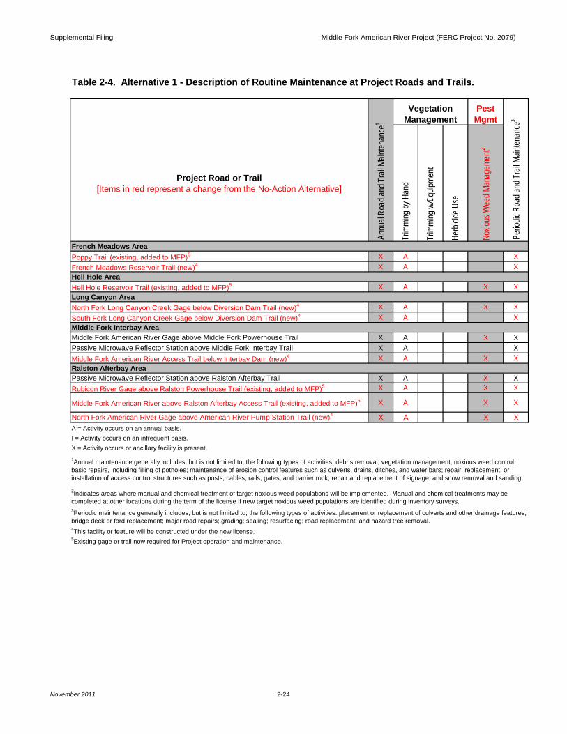
Supplemental Filing Middle Fork American River Project (FERC Project No. 2079)
November 2011 2-24
Project Road or Trail[Items in red represent a change from the No-Action Alternative]
Trim
ming
by H
and
Trim
ming
w/E
quipm
ent
Herb
icide
Use
Noxio
us W
eed M
anag
emen
t2
Poppy Trail (existing, added to MFP)5 X A XFrench Meadows Reservoir Trail (new)4 X A X
Hell Hole Reservoir Trail (existing, added to MFP)5 X A X X
North Fork Long Canyon Creek Gage below Diversion Dam Trail (new)4 X A X XSouth Fork Long Canyon Creek Gage below Diversion Dam Trail (new)4 X A X
Middle Fork American River Gage above Middle Fork Powerhouse Trail X A X XPassive Microwave Reflector Station above Middle Fork Interbay Trail X A XMiddle Fork American River Access Trail below Interbay Dam (new)4 X A X X
Passive Microwave Reflector Station above Ralston Afterbay Trail X A X XRubicon River Gage above Ralston Powerhouse Trail (existing, added to MFP)5 X A X X
Middle Fork American River above Ralston Afterbay Access Trail (existing, added to MFP)5 X A X X
North Fork American River Gage above American River Pump Station Trail (new)4 X A X XA = Activity occurs on an annual basis.I = Activity occurs on an infrequent basis. X = Activity occurs or ancillary facility is present.
Ralston Afterbay Area
1Annual maintenance generally includes, but is not limited to, the following types of activities: debris removal; vegetation management; noxious weed control; basic repairs, including filling of potholes; maintenance of erosion control features such as culverts, drains, ditches, and water bars; repair, replacement, or installation of access control structures such as posts, cables, rails, gates, and barrier rock; repair and replacement of signage; and snow removal and sanding.
2Indicates areas where manual and chemical treatment of target noxious weed populations will be implemented. Manual and chemical treatments may be completed at other locations during the term of the license if new target noxious weed populations are identified during inventory surveys.
Perio
dic R
oad a
nd T
rail M
ainten
ance
3
Annu
al Ro
ad an
d Tra
il Main
tenan
ce1
VegetationManagement
Pest Mgmt
Hell Hole Area
3Periodic maintenance generally includes, but is not limited to, the following types of activities: placement or replacement of culverts and other drainage features; bridge deck or ford replacement; major road repairs; grading; sealing; resurfacing; road replacement; and hazard tree removal.
Long Canyon Area
Table 2-4. Alternative 1 - Description of Routine Maintenance at Project Roads and Trails.
Middle Fork Interbay Area
French Meadows Area
5Existing gage or trail now required for Project operation and maintenance.
4This facility or feature will be constructed under the new license.
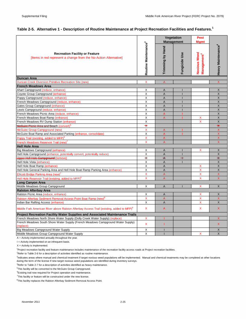
Supplemental Filing Middle Fork American River Project (FERC Project No. 2079)
November 2011 2-25
PestMgmt
Duncan Creek Diversion Primitive Recreation Site (new) X A X
Ahart Campground (reduce, enhance) X A I XCoyote Group Campground (enhance) X A I XPoppy Campground (reduce, enhance) X A I XFrench Meadows Campground (reduce, enhance) X A I XGates Group Campground (enhance) X A I XLewis Campground (reduce, enhance) X A I XFrench Meadows Picnic Area (reduce, enhance) X A I XFrench Meadows Boat Ramp (enhance) X A I X XFrench Meadows RV Dump Station (enhance) X X XMcGuire Picnic Area and Beach (convert)5 X XMcGuire Group Campground (new) X A I XMcGuire Boat Ramp and Associated Parking (enhance, consolidate) X A I XPoppy Trail (existing, added to MFP)6 X A XFrench Meadows Reservoir Trail (new)7 X A X
Big Meadows Campground (enhance) X A I X XHell Hole Campground (enhance, potentially convert, potentially reduce) X A I XUpper Hell Hole Campground (remove) X A I XHell Hole Vista (enhance) X A I XHell Hole Boat Ramp (enhance) X A X XHell Hole General Parking Area and Hell Hole Boat Ramp Parking Area (enhance) X A X XEllicott Bridge Parking Area (new)7 X A X XHell Hole Reservoir Trail (existing, added to MFP)6 X A X X
Middle Meadows Group Campground X A I X X
Ralston Picnic Area (reduce, enhance) X A X XRalston Afterbay Sediment Removal Access Point Boat Ramp (new)8 X A X XIndian Bar Rafting Access (enhance) X A X X
Middle Fork American River above Ralston Afterbay Access Trail (existing, added to MFP)6 X A X X
French Meadows North Shore Water Supply (Dolly Creek Water Supply) (replace) X I XFrench Meadows South Shore Water Supply (French Meadows Campground Water Supply) (replace) X I X
Big Meadows Campground Water Supply X I XMiddle Meadows Group Campground Water Supply X I X X
X = Activity is implemented.
2Refer to Table 2-6 for a description of activities identified as routine maintenance.
4Refer to Table 2-7 for a description of activities identified as heavy maintenance.
6Existing trail now required for Project operation and maintenance.7This facility or feature will be constructed under the new license.
A = Activity implemented annually throughout the year.
Trim
min
g by
Han
d
I = Activity implemented on an infrequent basis.
Hea
vy M
aint
enan
ce4
Table 2-5. Alternative 1 - Description of Routine Maintenance at Project Recreation Facilities and Features.1
Duncan Area
French Meadows Area
Hell Hole Area
VegetationManagement
Rou
tine
Mai
nten
ance
2
Recreation Facility or Feature[Items in red represent a change from the No-Action Alternative]
3Indicates areas where manual and chemical treatment if target noxious weed populations will be implemented. Manual and chemical treatments may be completed at other locations during the term of the license if new target noxious weed populations are identified during inventory surveys.
Long Canyon Area
Ralston Afterbay Area
Project Recreation Facility Water Supplies and Associated Maintenance Trails
8This facility replaces the Ralston Afterbay Sediment Removal Access Point.
Fun
gici
de U
se
5This facility will be converted to the McGuire Group Campground.
1Project recreation facility and feature maintenance includes maintenance of the recreation facility access roads at Project recreation facilities.
Nox
ious
Wee
d M
anag
emen
t3
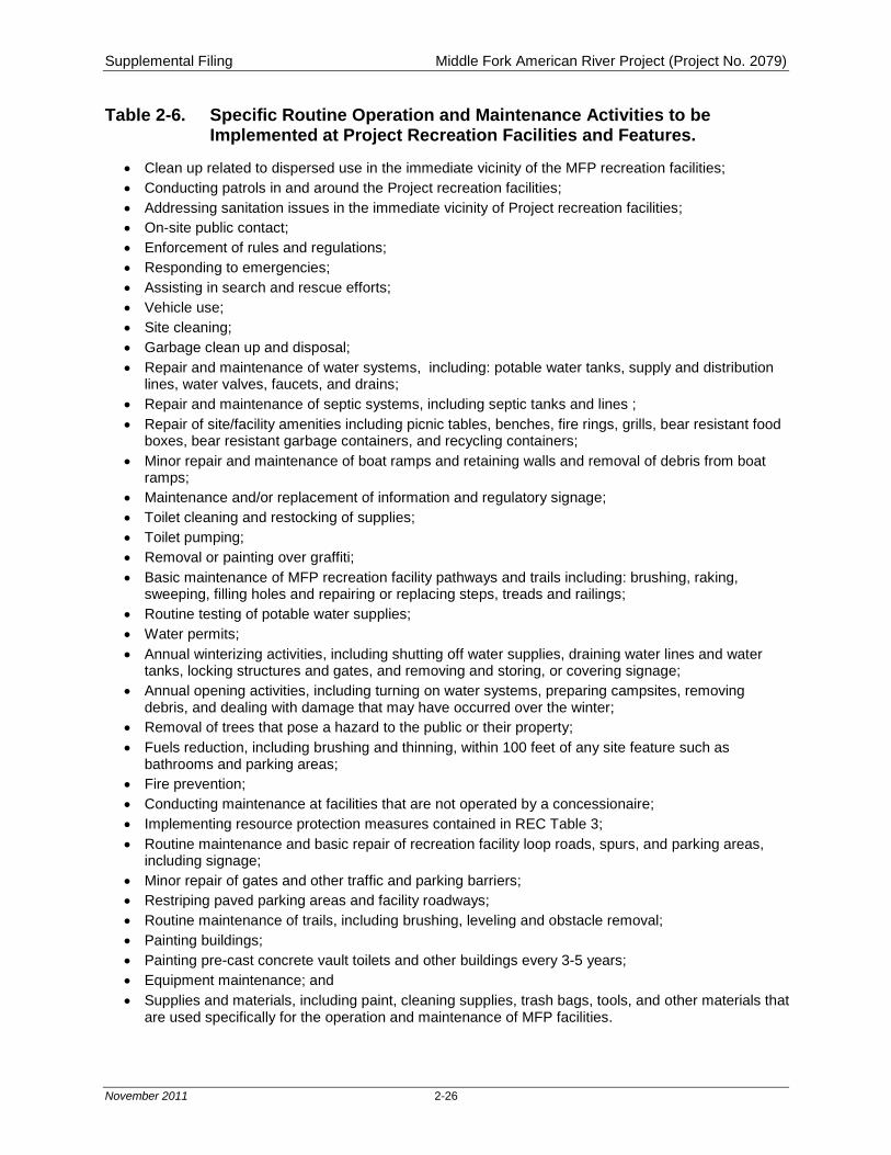
Supplemental Filing Middle Fork American River Project (Project No. 2079)
November 2011 2-26
Table 2-6. Specific Routine Operation and Maintenance Activities to be Implemented at Project Recreation Facilities and Features.
• Clean up related to dispersed use in the immediate vicinity of the MFP recreation facilities; • Conducting patrols in and around the Project recreation facilities; • Addressing sanitation issues in the immediate vicinity of Project recreation facilities; • On-site public contact; • Enforcement of rules and regulations; • Responding to emergencies; • Assisting in search and rescue efforts; • Vehicle use; • Site cleaning; • Garbage clean up and disposal; • Repair and maintenance of water systems, including: potable water tanks, supply and distribution
lines, water valves, faucets, and drains; • Repair and maintenance of septic systems, including septic tanks and lines ; • Repair of site/facility amenities including picnic tables, benches, fire rings, grills, bear resistant food
boxes, bear resistant garbage containers, and recycling containers; • Minor repair and maintenance of boat ramps and retaining walls and removal of debris from boat
ramps; • Maintenance and/or replacement of information and regulatory signage; • Toilet cleaning and restocking of supplies; • Toilet pumping; • Removal or painting over graffiti; • Basic maintenance of MFP recreation facility pathways and trails including: brushing, raking,
sweeping, filling holes and repairing or replacing steps, treads and railings; • Routine testing of potable water supplies; • Water permits; • Annual winterizing activities, including shutting off water supplies, draining water lines and water
tanks, locking structures and gates, and removing and storing, or covering signage; • Annual opening activities, including turning on water systems, preparing campsites, removing
debris, and dealing with damage that may have occurred over the winter; • Removal of trees that pose a hazard to the public or their property; • Fuels reduction, including brushing and thinning, within 100 feet of any site feature such as
bathrooms and parking areas; • Fire prevention; • Conducting maintenance at facilities that are not operated by a concessionaire; • Implementing resource protection measures contained in REC Table 3; • Routine maintenance and basic repair of recreation facility loop roads, spurs, and parking areas,
including signage; • Minor repair of gates and other traffic and parking barriers; • Restriping paved parking areas and facility roadways; • Routine maintenance of trails, including brushing, leveling and obstacle removal; • Painting buildings; • Painting pre-cast concrete vault toilets and other buildings every 3-5 years; • Equipment maintenance; and • Supplies and materials, including paint, cleaning supplies, trash bags, tools, and other materials that
are used specifically for the operation and maintenance of MFP facilities.
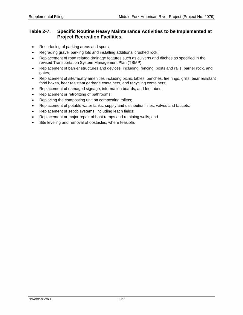
Supplemental Filing Middle Fork American River Project (Project No. 2079)
November 2011 2-27
Table 2-7. Specific Routine Heavy Maintenance Activities to be Implemented at Project Recreation Facilities.
• Resurfacing of parking areas and spurs; • Regrading gravel parking lots and installing additional crushed rock; • Replacement of road related drainage features such as culverts and ditches as specified in the
revised Transportation System Management Plan (TSMP); • Replacement of barrier structures and devices, including: fencing, posts and rails, barrier rock, and
gates; • Replacement of site/facility amenities including picnic tables, benches, fire rings, grills, bear resistant
food boxes, bear resistant garbage containers, and recycling containers; • Replacement of damaged signage, information boards, and fee tubes; • Replacement or retrofitting of bathrooms; • Replacing the composting unit on composting toilets; • Replacement of potable water tanks, supply and distribution lines, valves and faucets; • Replacement of septic systems, including leach fields; • Replacement or major repair of boat ramps and retaining walls; and • Site leveling and removal of obstacles, where feasible.
Supplemental Filing Middle Fork American River Project (FERC Project No. 2079)
November 2011
MAPS
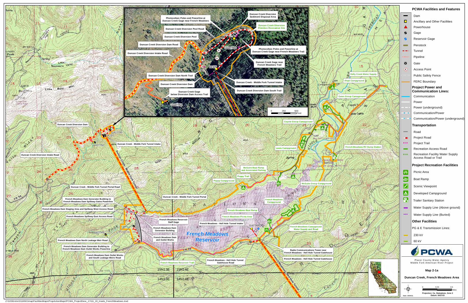
FR 96
FR 22
FR 96FR 96
FR 43
French MeadowsReservoir
11427400
French Meadows - Hell Hole Tunnel
Duncan Creek - Middle Fork Tunnel Intake
Duncan Creek Diversion Dam
Duncan Creek - Middle Fork Tunnel Portal
Duncan Creek - Middle Fork Tunnel Portal Road
French Meadows Dam Outlet Worksand South Leakage Weirs Road
11427750
11427700
French Meadows Damand Outlet Works
French Meadows DamGenerator Building
French Meadows - Hell Hole Tunnel Gatehouse Road
Radio Communications Tower nearFrench Meadows - Hell Hole Tunnel Gatehouse
French Meadows - Hell Hole Tunnel Gatehouse
French Meadows Boat Ramp
French Meadows Picnic Area
French MeadowsCampground
McGuire Group CampgroundPoppy Campground
McGuire Boat Rampand Associated Parking
Lewis Campground
Coyote Group Campground
Gates Group Campground
Ahart Campground
French Meadows Dam Generator Building toFrench Meadows Dam Outlet Works Powerline
French Meadows Dam Generator Building toFrench Meadows Dam Spillway Gates Powerline
French Meadows - Hell Hole Tunnel Intake
French Meadows Dam Staging Area and Spillway West Access Road
Dolly Creek Water Supply
French Meadows CampgroundWater Supply and Road
French Meadows ReservoirStaff Gage
14N13E 14N14E
15N13E 15N14E
French Meadows Spillway East Access Road
French Meadows Dam North Leakage Weir Road
French Meadows RV Dump Station
Duncan Creek Diversion Intake Road
DCDT
French Meadows Reservoir Trail
Poppy Trail
Duncan Creek - Middle Fork Tunnel
11427500
Date: 10/20/11Projection: Ca. Stateplane, Zone 2
Datum: NAD 83
Place r Cou nty W ater Ag en cyMidd le Fork Amer ica n R ive r P roje ct
0 0.50.25Miles
Z:\GIS\Entrix\3116501\map\FacilitiesMaps\PropActionMaps\PCWA_ProjectDesc_17i11i_10_Insets_FrenchMeadows.mxd
11427700
Duncan Creek - Middle Fork Tunnel
Duncan Creek Gagebelow Diversion Dam Access Trail
Photovoltaic Poles and Powerline atDuncan Creek Gage near French Meadows
Duncan Creek Diversion Pool Road
Duncan Creek Diversion Dam Road
Duncan Creek - Middle Fork Tunnel Intake
Duncan Creek Diversion Dam North Trail
Duncan Creek Diversion Dam South Trail
Duncan Creek Diversion Intake Road
Duncan Creek Diversion Pool
Duncan Creek Diversion Dam
Duncan Creek Gage nearFrench Meadows Trail
Photovoltaic Poles and Powerline atDuncan Creek Gage near French Meadows Trail
11427750
Duncan Creek DiversionSediment Disposal Area
DCDT
Duncan Creek DiversionPrimitive Recreation Site
0 500250Feet
168
B
B
B
Map 2-1aDuncan Creek, French Meadows Area
PCWA Facilities and Features
Project Road
TransportationRoad
Tunnel
Recreation Access Road
Gage
Water Supply Line (Buried)
Project Trail
FERC Boundary
Ancillary and Other Facilities
Powerhouse
Project Power andCommunication Lines:
Penstock
Dam
Gate
Project Recreation FacilitiesPicnic Area
PG & E Transmission Lines:
Boat Ramp
Developed Campground
Scenic Viewpoint
Other Facilities
Communication
Power
Power (underground)
Communication/Power
Communication/Power (underground)
230 kV
60 kV
Access Point
Public Safety Fence
Pipeline
Recreation Facility Water SupplyAccess Road or Trail
Water Supply Line (Above ground)
Reservoir Gage
Trailer Sanitary Station
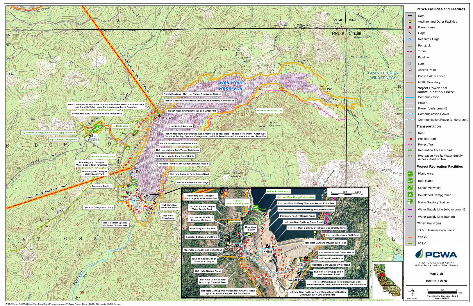
14N43
FR 2
14N09
FR 21
Hell HoleReservoir
11428700
French Meadows - Hell Hole Tunnel
Hell Hole - Middle Fork Tunnel Gatehouse
Hell Hole - Middle Fork Tunnel Gatehouse Road
Hell Hole Damand Outlet WorksOperator Cottages and Shop
Dormitory Facility
Dormitory and CottagesWater Supply Tank
Hell Hole Campground
Hell Hole Vista
Big Meadows Campground
French Meadows - Hell Hole Tunnel Portal Road
French Meadows Powerhouse Road
Hell Hole Substation
French Meadows Powerhouse and Switchyard
French Meadows Powerhouse Penstock and Butterfly Valve HouseFrench Meadows Powerhouse to French Meadows Powerhouse Penstock
and Butterfly Valve House Communication Line / Powerline
French Meadows Powerhouse and Switchyard to Hell Hole - Middle Fork Tunnel Gatehouse,Dormitory Facility, Operator Cottages and Hell Hole Powerhouse Communication Line / Powerline
Hell Hole - M iddle Fork Tunnel
Hell Hole - Middle Fork Tunnel Intake
11427200
Hell Hole Dam SpillwayDischarge Channel Road
Hell Hole Dam and Powerhouse Road
Hell HolePowerhouse
French Meadows - Hell Hole Tunnel Removable Section
Dormitory and CottagesWater Supply Tank Powerline
FR 2
Big Meadows Campground Water Supply and Road
Hell Hole Reservoir Staff Gage
15N14E 15N15E
14N14E 14N15E
GRANITE CHIEFWILDERNESS
HHDS
Hell Hole Reservoir Trail
11428800
Projection: Ca. Stateplane, Zone 2Datum: NAD 83
Place r Cou nty W ater Ag en cyMidd le Fork Amer ica n R ive r P roje ct
0 0.50.25Miles
Z:\GIS\Entrix\3116501\map\FacilitiesMaps\PropActionMaps\PCWA_ProjectDesc_17i11i_10_Insets_HellHole.mxd
11428800
Hell Hole Boat Ramp Parking Area
Hell Hole Dam Spillway Northern Access Point Road
Hell Hole Boat Ramp
Hell HoleGeneral Parking Area
DormitoryFacility
Hell Hole Dam General Parking Area Barrier Fence
Hell Hole Staging AreasHell Hole Staging Areas
Dormitory Facility Barrier Fence
Hell Hole Powerhouse
Hell Hole Dam Leakage Weir Road
Hell Hole Dam and Powerhouse Road
Rubicon River Gage belowHell Hole Dam Road
Hell Hole Dam and Outlet Works
Hell Hole Dam Spillway Discharge Channel RoadSpur to Communication Line / Powerline
Hell Hole Powerhouse to Rubicon River Gagebelow Hell Hole Dam Communication Line / Powerline
Dormitory Facility Road
Hell Hole Dam SpillwayDischarge Channel Road
Dormitory and CottagesWater Supply Tank Powerline
Operator Cottages and Shop
Dormitory and CottagesWater Supply Tank
Spur on North Side ofOperator Cottages
Operator Cottages and Shop Road
Spur on South Side ofOperator Cottages
Hell Hole Reservoir Staff Gage
HHDS
Hell Hole Dam Spillway Crest Gates Control Building
Hell Hole Dam Spillway Crest Gates Control BuildingCommunication Line / Powerline
Hell Hole Dam Spillway Gates Road
0 1,000500Feet
168
B
B
B
Map 2-1bHell Hole Area
Date: 10/20/11
PCWA Facilities and Features
Project Road
TransportationRoad
Tunnel
Recreation Access Road
Gage
Water Supply Line (Buried)
Project Trail
FERC Boundary
Ancillary and Other Facilities
Powerhouse
Project Power andCommunication Lines:
Penstock
Dam
Gate
Project Recreation FacilitiesPicnic Area
PG & E Transmission Lines:
Boat Ramp
Developed Campground
Scenic Viewpoint
Other Facilities
Communication
Power
Power (underground)
Communication/Power
Communication/Power (underground)
230 kV
60 kV
Access Point
Public Safety Fence
Pipeline
Recreation Facility Water SupplyAccess Road or Trail
Water Supply Line (Above ground)
Reservoir Gage
Trailer Sanitary Station
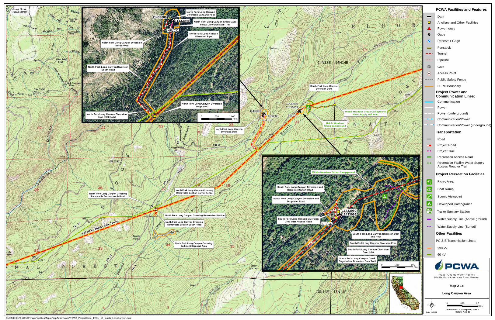
FR 2
South Fork Long CanyonDiversion Dam
North Fork Long CanyonDiversion Dam
Middle MeadowsGroup Campground
North Fork Long Canyon Crossing Removable Section
North Fork Long Canyon CrossingRemovable Section South Road
North Fork Long Canyon CrossingRemovable Section North Road
FR 23
North Fork Long Canyon CrossingSediment Disposal Area
North Fork Long Canyon CrossingRemovable Section Barrier Fence
FR 2
FR 2
FR 2 2
FR 25
Middle Meadows Group CampgroundWater Supply and Road
14N13E 14N14E
13N13E 13N14E
NFLCC
SFLCC
Hell Hole - Middle Fork Tunnel
11433085
114330801143306511433060
Projection: Ca. Stateplane, Zone 2Datum: NAD 83
Place r Cou nty W ater Ag en cyMidd le Fork Amer ica n R ive r P roje ct
0 0.50.25Miles
Z:\GIS\Entrix\3116501\map\FacilitiesMaps\PropActionMaps\PCWA_ProjectDesc_17i11i_10_Insets_LongCanyon.mxd
1143306011433065
South Fork Long Canyon DiversionDrop Inlet
South Fork Long Canyon Diversion andDrop Inlet Road
South Fork Long Canyon Diversion Pipe
South Fork Long Canyon Diversion Damand Pool
Middle Meadows Group Campground
South Fork Long Canyon Diversion andDrop Inlet Cutoff Road
South Fork Long Canyon DiversionDrop Inlet Access Road SFLCC
South Fork Long Canyon CreekGage below Diversion Dam Trail
1143308011433085
North Fork Long Canyon DiversionNorth Road
North Fork Long Canyon DiversionSouth Road
North Fork Long Canyon DiversionDrop Inlet Road
North Fork Long Canyon DiversionDrop Inlet
North Fork Long CanyonDiversion Pipe
North Fork Long CanyonDiversion Dam and Pool
NFLCC
North Fork Long Canyon Creek Gagebelow Diversion Dam Trail
0 1,000500Feet
0 500250Feet
168
B
B
B
Map 2-1cLong Canyon Area
Date: 10/20/11
PCWA Facilities and Features
Project Road
TransportationRoad
Tunnel
Recreation Access Road
Gage
Water Supply Line (Buried)
Project Trail
FERC Boundary
Ancillary and Other Facilities
Powerhouse
Project Power andCommunication Lines:
Penstock
Dam
Gate
Project Recreation FacilitiesPicnic Area
PG & E Transmission Lines:
Boat Ramp
Developed Campground
Scenic Viewpoint
Other Facilities
Communication
Power
Power (underground)
Communication/Power
Communication/Power (underground)
230 kV
60 kV
Access Point
Public Safety Fence
Pipeline
Recreation Facility Water SupplyAccess Road or Trail
Water Supply Line (Above ground)
Reservoir Gage
Trailer Sanitary Station
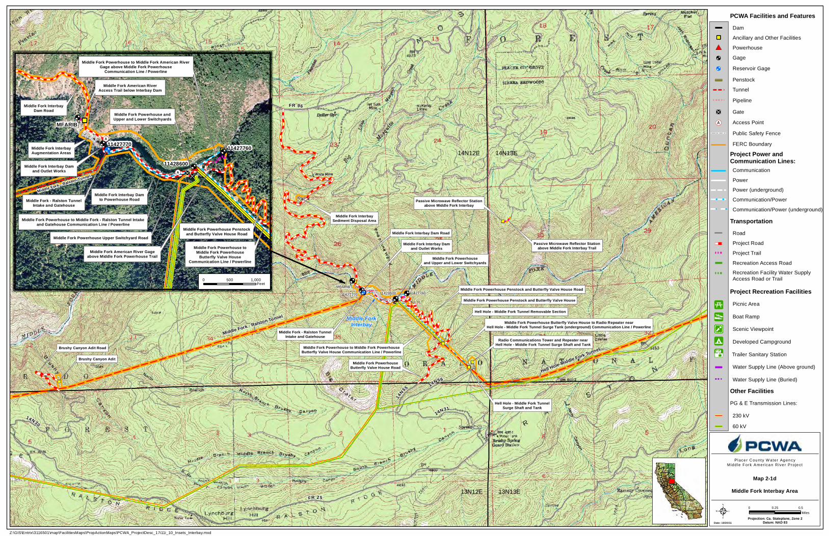
14N55 14N56
11427760
FR 96
11427770
Middle Fork Interbay Dam Road
Passive Microwave Reflector Stationabove Middle Fork Interbay
Middle Fork Interbay Damand Outlet Works
Middle Fork - Ralston TunnelIntake and Gatehouse
Middle Fork Powerhouseand Upper and Lower Switchyards
Middle Fork Powerhouse Penstock and Butterfly Valve House Road
Middle Fork Powerhouse Penstock and Butterfly Valve House
Middle Fork PowerhouseButterfly Valve House Road
Middle Fork Powerhouse to Middle Fork PowerhouseButterfly Valve House Communication Line / Powerline
Middle Fork Powerhouse Butterfly Valve House to Radio Repeater nearHell Hole - Middle Fork Tunnel Surge Tank (underground) Communication Line / Powerline
Hell Hole - Middle Fork TunnelSurge Shaft and Tank
Radio Communications Tower and Repeater nearHell Hole - Middle Fork Tunnel Surge Shaft and Tank
Middle Fork - Ralston Tunnel
Middle Fork InterbaySediment Disposal Area
Hell Hole-Middle Fork Tunnel
Passive Microwave Reflector Stationabove Middle Fork Interbay Trail
11428600
Hell Hole - Middle Fork Tunnel Removable Section
Middle Fork - Ralston Tunnel
Brushy Canyon Adit
Brushy Canyon Adit Road
14N3114N30
FR 2513N12E 13N13E
14N12E 14N13E
MFARIB
FR 96
Middle ForkInterbay
Projection: Ca. Stateplane, Zone 2Datum: NAD 83
Place r Cou nty W ater Ag en cyMidd le Fork Amer ica n R ive r P roje ct
0 0.50.25Miles
Z:\GIS\Entrix\3116501\map\FacilitiesMaps\PropActionMaps\PCWA_ProjectDesc_17i11i_10_Insets_Interbay.mxd
11427770
Middle Fork InterbayDam Road
Middle Fork Powerhouse Upper Switchyard Road
Middle Fork Powerhouse to Middle Fork American RiverGage above Middle Fork Powerhouse
Communication Line / Powerline
Middle Fork Powerhouse to Middle Fork - Ralston Tunnel Intakeand Gatehouse Communication Line / Powerline
Middle Fork American River Gageabove Middle Fork Powerhouse Trail
11427760
11428600Middle Fork Interbay Damand Outlet Works
Middle Fork Powerhouse andUpper and Lower Switchyards
Middle Fork - Ralston TunnelIntake and Gatehouse
Middle Fork - Ralston Tunnel
Middle Fork Powerhouse Penstockand Butterfly Valve House Road
Middle Fork Powerhouse toMiddle Fork Powerhouse
Butterfly Valve HouseCommunication Line / Powerline
Middle Fork Interbay Damto Powerhouse Road
MFARIB
Middle Fork American RiverAccess Trail below Interbay Dam
Middle Fork InterbayAugmentation Areas
0 1,000500Feet
168
B
B
B
Map 2-1dMiddle Fork Interbay Area
Date: 10/20/11
PCWA Facilities and Features
Project Road
TransportationRoad
Tunnel
Recreation Access Road
Gage
Water Supply Line (Buried)
Project Trail
FERC Boundary
Ancillary and Other Facilities
Powerhouse
Project Power andCommunication Lines:
Penstock
Dam
Gate
Project Recreation FacilitiesPicnic Area
PG & E Transmission Lines:
Boat Ramp
Developed Campground
Scenic Viewpoint
Other Facilities
Communication
Power
Power (underground)
Communication/Power
Communication/Power (underground)
230 kV
60 kV
Access Point
Public Safety Fence
Pipeline
Recreation Facility Water SupplyAccess Road or Trail
Water Supply Line (Above ground)
Reservoir Gage
Trailer Sanitary Station
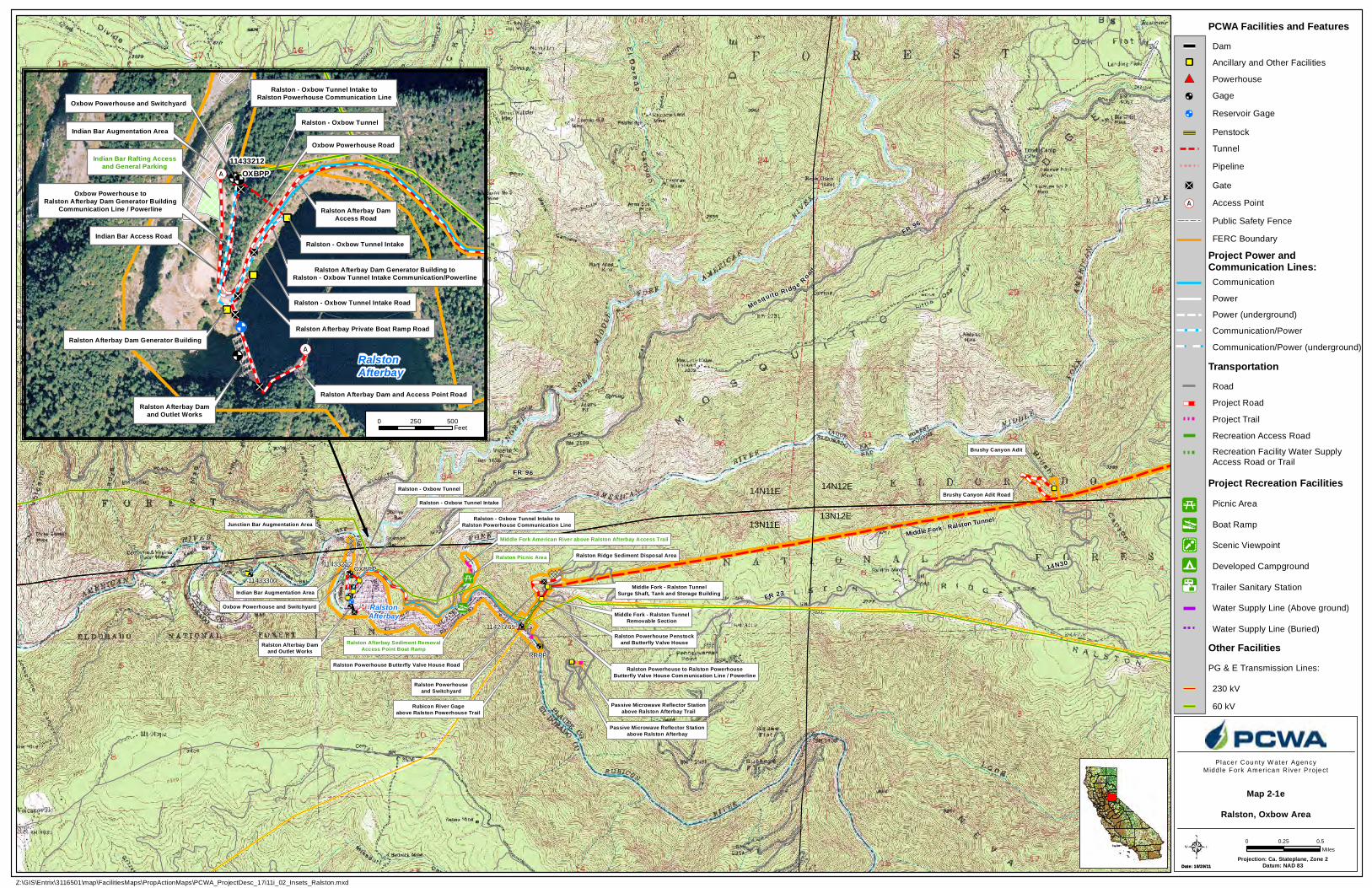
RalstonAfterbay
Ralston - Oxbow Tunnel
Oxbow Powerhouse and Switchyard
Ralston Afterbay Damand Outlet Works
Ralston - Oxbow Tunnel Intake toRalston Powerhouse Communication Line
Ralston Powerhouseand Switchyard
Ralston Powerhouse Penstockand Butterfly Valve House
Passive Microwave Reflector Stationabove Ralston Afterbay
Ralston Powerhouse to Ralston PowerhouseButterfly Valve House Communication Line / Powerline
Middle Fork - Ralston TunnelSurge Shaft, Tank and Storage Building
Ralston Powerhouse Butterfly Valve House Road
Ralston Picnic Area11433212
Passive Microwave Reflector Stationabove Ralston Afterbay Trail
Ralston Ridge Sediment Disposal Area
Ralston - Oxbow Tunnel Intake
Middle Fork - Ralston TunnelRemovable Section
Brushy Canyon Adit
Brushy Canyon Adit Road
14N30
FR 96
14N11E 14N12E
13N11E13N12E
Ralston Afterbay Sediment RemovalAccess Point Boat Ramp
RRRP
OXBPP
Indian Bar Augmentation Area
Junction Bar Augmentation Area
Rubicon River Gageabove Ralston Powerhouse Trail
Middle Fork American River above Ralston Afterbay Access Trail
FR 23
Mosquito Ridg e Road
FR 96
Middle Fork - Ralston Tunnel
11433300
11427765
Date: 10/19/11Projection: Ca. Stateplane, Zone 2
Datum: NAD 83
Place r Cou nty W ater Ag en cyMidd le Fork Amer ica n R ive r P roje ct
0 0.50.25Miles
Z:\GIS\Entrix\3116501\map\FacilitiesMaps\PropActionMaps\PCWA_ProjectDesc_17i11i_02_Insets_Ralston.mxd
11433212
Ralston - Oxbow Tunnel Intake Road
Ralston Afterbay Private Boat Ramp Road
Ralston - Oxbow Tunnel Intake
Oxbow Powerhouse toRalston Afterbay Dam Generator Building
Communication Line / Powerline
Oxbow Powerhouse Road
Ralston Afterbay Dam Generator Building
Ralston Afterbay Dam and Access Point Road
Ralston Afterbay Dam Generator Building toRalston - Oxbow Tunnel Intake Communication/Powerline
Indian Bar Rafting Accessand General Parking
Ralston Afterbay Damand Outlet Works
Oxbow Powerhouse and Switchyard
Ralston - Oxbow Tunnel
RalstonAfterbay
Ralston - Oxbow Tunnel Intake toRalston Powerhouse Communication Line
Indian Bar Access Road
Ralston Afterbay DamAccess Road
Indian Bar Augmentation Area
OXBPP
0 500250Feet
168
B
B
B
Map 2-1eRalston, Oxbow Area
Date: 10/20/11
PCWA Facilities and Features
Project Road
TransportationRoad
Tunnel
Recreation Access Road
Gage
Water Supply Line (Buried)
Project Trail
FERC Boundary
Ancillary and Other Facilities
Powerhouse
Project Power andCommunication Lines:
Penstock
Dam
Gate
Project Recreation FacilitiesPicnic Area
PG & E Transmission Lines:
Boat Ramp
Developed Campground
Scenic Viewpoint
Other Facilities
Communication
Power
Power (underground)
Communication/Power
Communication/Power (underground)
230 kV
60 kV
Access Point
Public Safety Fence
Pipeline
Recreation Facility Water SupplyAccess Road or Trail
Water Supply Line (Above ground)
Reservoir Gage
Trailer Sanitary Station
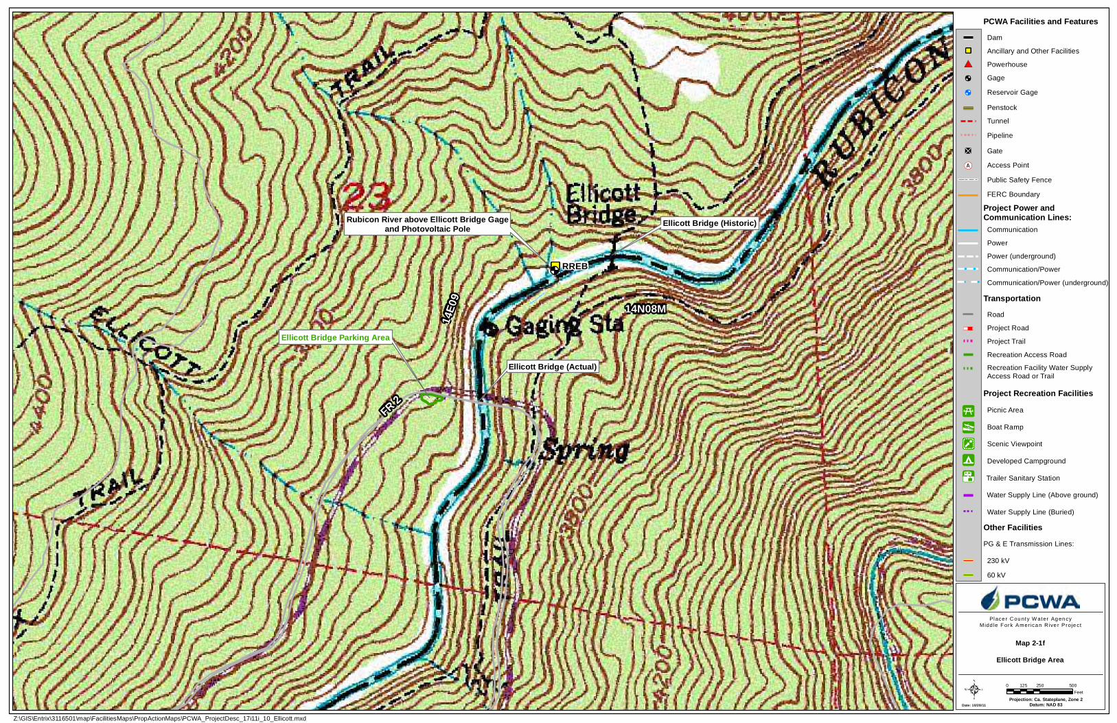
Projection: Ca. Stateplane, Zone 2Datum: NAD 83
Ellicott Bridge (Actual)
Ellicott Bridge Parking Area
RREB
FR 2
14N08M
14E0
9
Ellicott Bridge (Historic)Rubicon River above Ellicott Bridge Gageand Photovoltaic Pole
Rubicon River
Z:\GIS\Entrix\3116501\map\FacilitiesMaps\PropActionMaps\PCWA_ProjectDesc_17i11i_10_Ellicott.mxd
Place r Cou nty W ater Ag en cyMidd le Fork Amer ica n R ive r P roje ct
0 250 500125Feet
Date: 10/28/11
Map 2-1fEllicott Bridge Area
PCWA Facilities and Features
Project Road
TransportationRoad
Tunnel
Recreation Access Road
Gage
Water Supply Line (Buried)
Project Trail
FERC Boundary
Ancillary and Other Facilities
Powerhouse
Project Power andCommunication Lines:
Penstock
Dam
Gate
Project Recreation FacilitiesPicnic Area
PG & E Transmission Lines:
Boat Ramp
Developed Campground
Scenic Viewpoint
Other Facilities
Communication
Power
Power (underground)
Communication/Power
Communication/Power (underground)
230 kV
60 kV
Access Point
Public Safety Fence
Pipeline
Recreation Facility Water SupplyAccess Road or Trail
Water Supply Line (Above ground)
Reservoir Gage
Trailer Sanitary Station
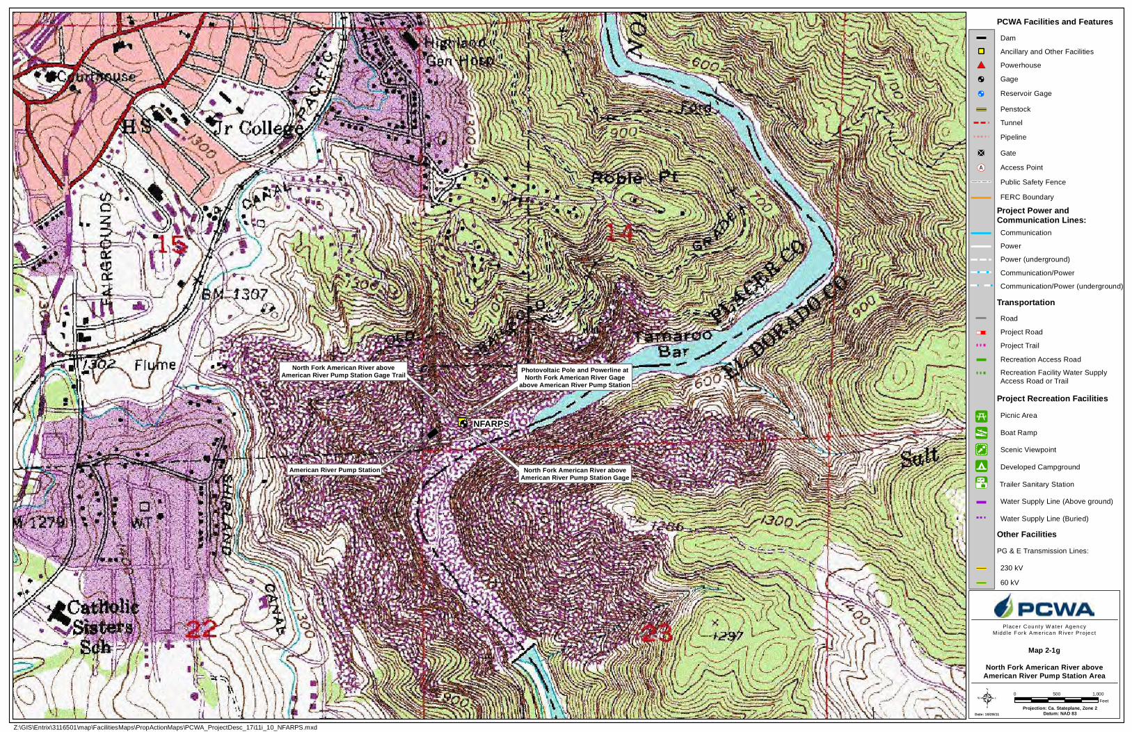
Date: 10/28/11Projection: Ca. Stateplane, Zone 2
Datum: NAD 83
North Fork American River aboveAmerican River Pump Station Gage
North Fork American River aboveAmerican River Pump Station Gage Trail Photovoltaic Pole and Powerline at
North Fork American River Gageabove American River Pump Station
American River Pump Station
NFARPS
Z:\GIS\Entrix\3116501\map\FacilitiesMaps\PropActionMaps\PCWA_ProjectDesc_17i11i_10_NFARPS.mxd
Place r Cou nty W ater Ag en cyMidd le Fork Amer ica n R ive r P roje ct
0 1,000500Feet
Map 2-1gNorth Fork American River above
American River Pump Station Area
PCWA Facilities and Features
Project Road
TransportationRoad
Tunnel
Recreation Access Road
Gage
Water Supply Line (Buried)
Project Trail
FERC Boundary
Ancillary and Other Facilities
Powerhouse
Project Power andCommunication Lines:
Penstock
Dam
Gate
Project Recreation FacilitiesPicnic Area
PG & E Transmission Lines:
Boat Ramp
Developed Campground
Scenic Viewpoint
Other Facilities
Communication
Power
Power (underground)
Communication/Power
Communication/Power (underground)
230 kV
60 kV
Access Point
Public Safety Fence
Pipeline
Recreation Facility Water SupplyAccess Road or Trail
Water Supply Line (Above ground)
Reservoir Gage
Trailer Sanitary Station
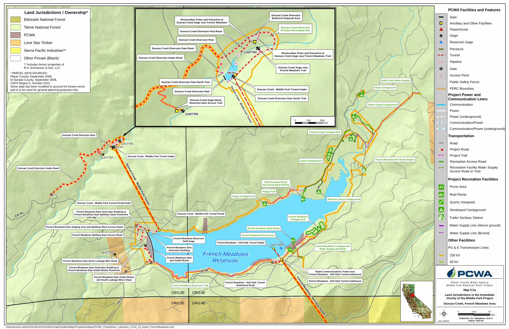
FR 96
FR 22
FR 96FR 96
FR 43
French MeadowsReservoir
11427400
French Meadows - Hell Hole Tunnel
Duncan Creek - Middle Fork Tunnel Intake
Duncan Creek Diversion Dam
Duncan Creek - Middle Fork Tunnel Portal
Duncan Creek - Middle Fork Tunnel Portal Road
French Meadows Dam Outlet Worksand South Leakage Weirs Road
11427750
11427700
French Meadows Damand Outlet Works
French Meadows DamGenerator Building
French Meadows - Hell Hole Tunnel Gatehouse Road
Radio Communications Tower nearFrench Meadows - Hell Hole Tunnel Gatehouse
French Meadows - Hell Hole Tunnel Gatehouse
French Meadows Boat Ramp
French Meadows Picnic Area
French MeadowsCampground
McGuire Group CampgroundPoppy Campground
McGuire Boat Rampand Associated Parking
Lewis Campground
Coyote Group Campground
Gates Group Campground
Ahart Campground
French Meadows Dam Generator Building toFrench Meadows Dam Outlet Works Powerline
French Meadows Dam Generator Building toFrench Meadows Dam Spillway Gates Powerline
French Meadows - Hell Hole Tunnel Intake
French Meadows Dam Staging Area and Spillway West Access Road
Dolly Creek Water Supply
French Meadows CampgroundWater Supply and Road
French Meadows ReservoirStaff Gage
14N13E 14N14E
15N13E 15N14E
French Meadows Spillway East Access Road
French Meadows Dam North Leakage Weir Road
French Meadows RV Dump Station
Duncan Creek Diversion Intake Road
DCDT
Poppy Trail
French Meadows Reservoir Trail
Duncan Creek - Middle Fork Tunnel
11427500
Date: 10/20/11Projection: Ca. Stateplane, Zone 2
Datum: NAD 83
Place r Cou nty W ater Ag en cyMidd le Fork Amer ica n R ive r P roje ct
0 0.50.25Miles
\\Sacramento-nas\GIS\GIS\Entrix\3116501\map\FacilitiesMaps\PropActionMaps\PCWA_ProjectDesc_LandJuris_17i11i_10_Insets_FrenchMeadows.mxd
11427700
Duncan Creek - Middle Fork Tunnel
Duncan Creek Gage belowDiversion Dam Access Trail
Photovoltaic Poles and Powerline atDuncan Creek Gage near French Meadows
Duncan Creek Diversion Pool Road
Duncan Creek Diversion Dam Road
Duncan Creek - Middle Fork Tunnel Intake
Duncan Creek Diversion Dam North Trail
Duncan Creek Diversion Dam South Trail
Duncan Creek Diversion Intake Road
Duncan Creek Diversion Pool
Duncan Creek Diversion Dam
Duncan Creek Gage nearFrench Meadows Trail
Photovoltaic Poles and Powerline atDuncan Creek Gage near French Meadows Trail
11427750
Duncan Creek DiversionSediment Disposal Area
DCDT
Duncan Creek DiversionPrimitive Recreation Site
0 500250Feet
168
B
B
B
PCWA Facilities and Features
Project Road
TransportationRoad
Tunnel
Recreation Access Road
Gage
Water Supply Line (Buried)
Project Trail
FERC Boundary
Ancillary and Other Facilities
Powerhouse
Project Power andCommunication Lines:
Penstock
Dam
Gate
Project Recreation FacilitiesPicnic Area
PG & E Transmission Lines:
Boat Ramp
Developed Campground
Scenic Viewpoint
Other Facilities
Communication
Power
Power (underground)
Communication/Power
Communication/Power (underground)
230 kV
60 kV
Access Point
Public Safety Fence
Pipeline
Recreation Facility Water SupplyAccess Road or Trail
Water Supply Line (Above ground)
Reservoir Gage
Trailer Sanitary Station
Land Jurisdictions in the ImmediateVicinity of the Middle Fork Project
Duncan Creek, French Meadows Area
Map 2-2a
* PARCEL DATA SOURCES: Placer County, September 2009,El Dorado County, September 2009,USFS Region 5, October 2010.Some data has been modified to account for known errorsand is to be used for general planning purposes only.
Land Jurisdictions / Ownership*Eldorado National Forest
Tahoe National Forest
Lone Star Timber
PCWA
Sierra Pacific Industries**
Other Private (Blank)** Includes former properties ofR.H. Emmerson & Son, LLC
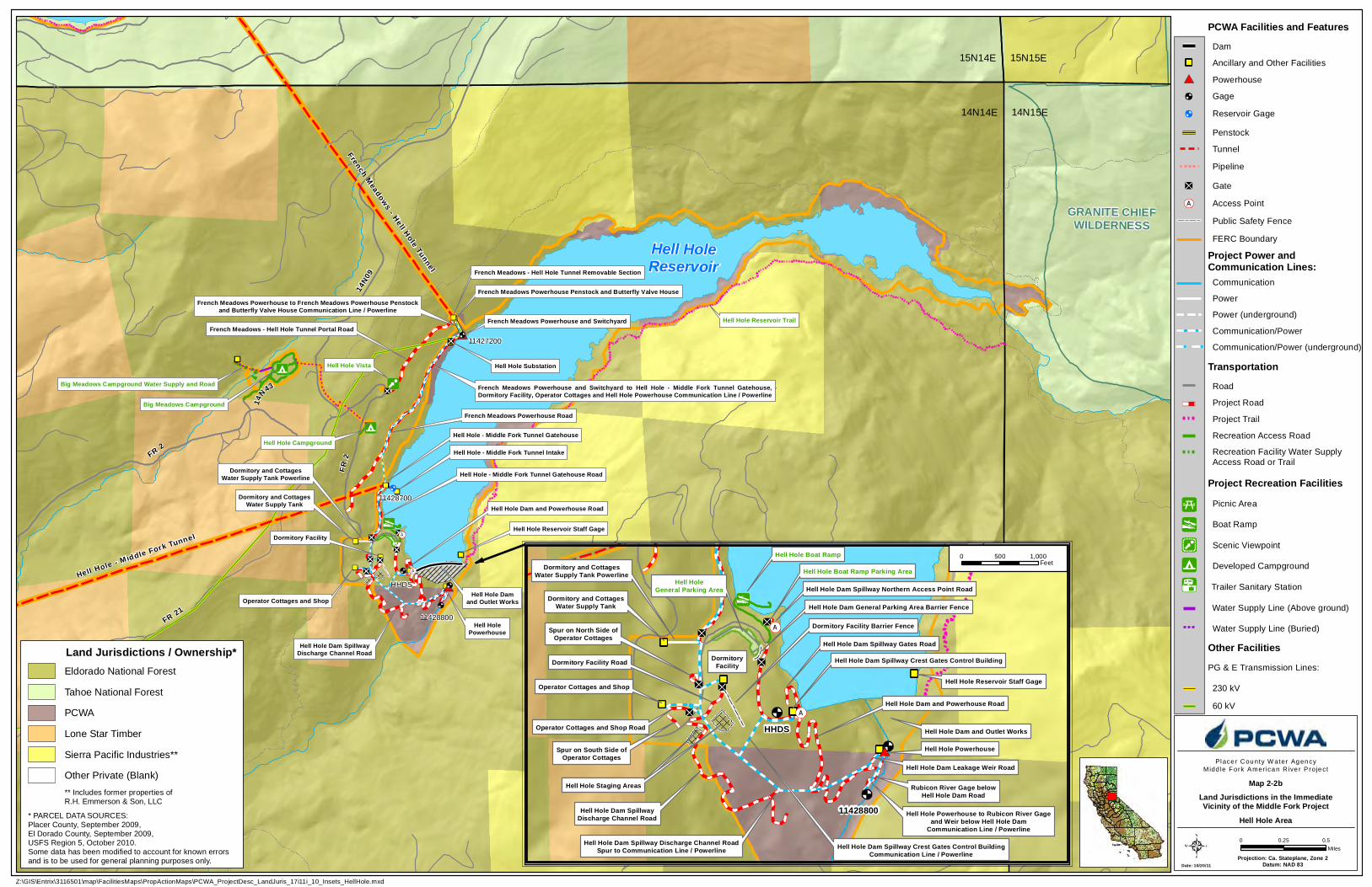
14N43
FR 2
14N09
FR 21
Hell HoleReservoir
11428700
French Meadows - Hell Hole Tunnel
Hell Hole - Middle Fork Tunnel Gatehouse
Hell Hole - Middle Fork Tunnel Gatehouse Road
Hell Hole Damand Outlet WorksOperator Cottages and Shop
Dormitory Facility
Dormitory and CottagesWater Supply Tank
Hell Hole Campground
Hell Hole Vista
Big Meadows Campground
French Meadows - Hell Hole Tunnel Portal Road
French Meadows Powerhouse Road
Hell Hole Substation
French Meadows Powerhouse and Switchyard
French Meadows Powerhouse Penstock and Butterfly Valve HouseFrench Meadows Powerhouse to French Meadows Powerhouse Penstock
and Butterfly Valve House Communication Line / Powerline
French Meadows Powerhouse and Switchyard to Hell Hole - Middle Fork Tunnel Gatehouse,Dormitory Facility, Operator Cottages and Hell Hole Powerhouse Communication Line / Powerline
Hell Hole - M iddle Fork Tunnel
Hell Hole - Middle Fork Tunnel Intake
11427200
Hell Hole Dam SpillwayDischarge Channel Road
Hell Hole Dam and Powerhouse Road
Hell HolePowerhouse
French Meadows - Hell Hole Tunnel Removable Section
Dormitory and CottagesWater Supply Tank Powerline
FR 2
Big Meadows Campground Water Supply and Road
Hell Hole Reservoir Staff Gage
15N14E 15N15E
14N14E 14N15E
GRANITE CHIEFWILDERNESS
HHDS
Hell Hole Reservoir Trail
11428800
Date: 10/20/11Projection: Ca. Stateplane, Zone 2
Datum: NAD 83
Place r Cou nty W ater Ag en cyMidd le Fork Amer ica n R ive r P roje ct
0 0.50.25Miles
Z:\GIS\Entrix\3116501\map\FacilitiesMaps\PropActionMaps\PCWA_ProjectDesc_LandJuris_17i11i_10_Insets_HellHole.mxd
11428800
Hell Hole Boat Ramp Parking Area
Hell Hole Dam Spillway Northern Access Point Road
Hell Hole Boat Ramp
Hell HoleGeneral Parking Area
DormitoryFacility
Hell Hole Dam General Parking Area Barrier Fence
Hell Hole Staging AreasHell Hole Staging Areas
Dormitory Facility Barrier Fence
Hell Hole Powerhouse
Hell Hole Dam Leakage Weir Road
Hell Hole Dam and Powerhouse Road
Rubicon River Gage belowHell Hole Dam Road
Hell Hole Dam and Outlet Works
Hell Hole Dam Spillway Discharge Channel RoadSpur to Communication Line / Powerline
Hell Hole Powerhouse to Rubicon River Gageand Weir below Hell Hole Dam
Communication Line / Powerline
Dormitory Facility Road
Hell Hole Dam SpillwayDischarge Channel Road
Dormitory and CottagesWater Supply Tank Powerline
Operator Cottages and Shop
Dormitory and CottagesWater Supply Tank
Spur on North Side ofOperator Cottages
Operator Cottages and Shop Road
Spur on South Side ofOperator Cottages
Hell Hole Reservoir Staff Gage
HHDS
Hell Hole Dam Spillway Crest Gates Control Building
Hell Hole Dam Spillway Crest Gates Control BuildingCommunication Line / Powerline
Hell Hole Dam Spillway Gates Road
0 1,000500Feet
168
B
B
B
PCWA Facilities and Features
Project Road
TransportationRoad
Tunnel
Recreation Access Road
Gage
Water Supply Line (Buried)
Project Trail
FERC Boundary
Ancillary and Other Facilities
Powerhouse
Project Power andCommunication Lines:
Penstock
Dam
Gate
Project Recreation FacilitiesPicnic Area
PG & E Transmission Lines:
Boat Ramp
Developed Campground
Scenic Viewpoint
Other Facilities
Communication
Power
Power (underground)
Communication/Power
Communication/Power (underground)
230 kV
60 kV
Access Point
Public Safety Fence
Pipeline
Recreation Facility Water SupplyAccess Road or Trail
Water Supply Line (Above ground)
Reservoir Gage
Trailer Sanitary Station
Land Jurisdictions in the ImmediateVicinity of the Middle Fork Project
Hell Hole Area
Map 2-2b
* PARCEL DATA SOURCES: Placer County, September 2009,El Dorado County, September 2009,USFS Region 5, October 2010.Some data has been modified to account for known errorsand is to be used for general planning purposes only.
Land Jurisdictions / Ownership*Eldorado National Forest
Tahoe National Forest
Lone Star Timber
PCWA
Sierra Pacific Industries**
Other Private (Blank)** Includes former properties ofR.H. Emmerson & Son, LLC
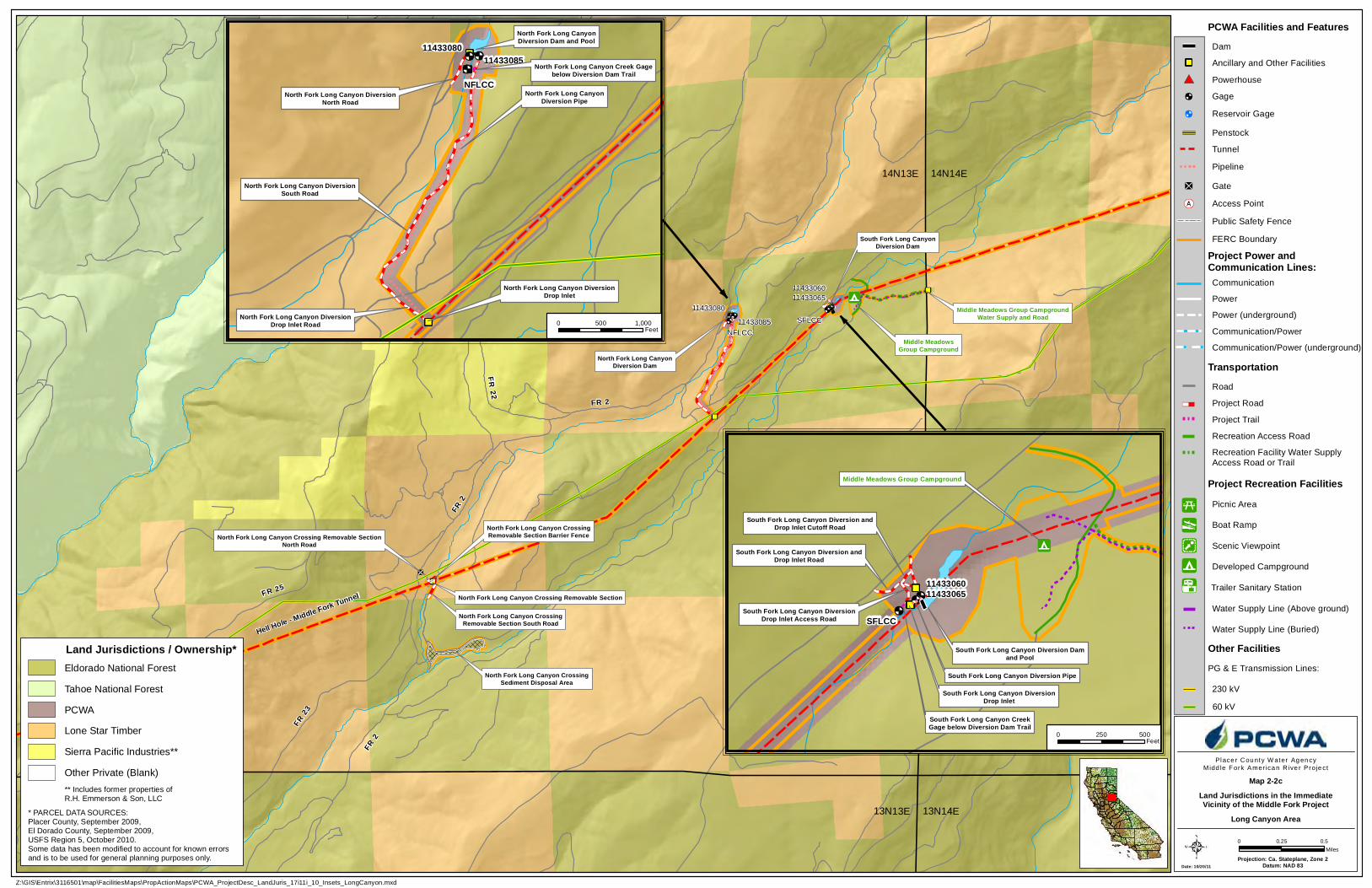
FR 2
South Fork Long CanyonDiversion Dam
North Fork Long CanyonDiversion Dam
Middle MeadowsGroup Campground
North Fork Long Canyon Crossing Removable Section
North Fork Long Canyon CrossingRemovable Section South Road
North Fork Long Canyon Crossing Removable SectionNorth Road
FR 23
North Fork Long Canyon CrossingSediment Disposal Area
North Fork Long Canyon CrossingRemovable Section Barrier Fence
FR 2
FR 2
FR 2 2
FR 25
Middle Meadows Group CampgroundWater Supply and Road
14N13E 14N14E
13N13E 13N14E
NFLCC
SFLCC
Hell Hole - Middle Fork Tunnel
11433085
114330801143306511433060
Date: 10/20/11Projection: Ca. Stateplane, Zone 2
Datum: NAD 83
Place r Cou nty W ater Ag en cyMidd le Fork Amer ica n R ive r P roje ct
0 0.50.25Miles
Z:\GIS\Entrix\3116501\map\FacilitiesMaps\PropActionMaps\PCWA_ProjectDesc_LandJuris_17i11i_10_Insets_LongCanyon.mxd
1143306011433065
South Fork Long Canyon DiversionDrop Inlet
South Fork Long Canyon Diversion andDrop Inlet Road
South Fork Long Canyon Diversion Pipe
South Fork Long Canyon Diversion Damand Pool
Middle Meadows Group Campground
South Fork Long Canyon Diversion andDrop Inlet Cutoff Road
South Fork Long Canyon DiversionDrop Inlet Access Road SFLCC
South Fork Long Canyon CreekGage below Diversion Dam Trail
1143308011433085
North Fork Long Canyon DiversionNorth Road
North Fork Long Canyon DiversionSouth Road
North Fork Long Canyon DiversionDrop Inlet Road
North Fork Long Canyon DiversionDrop Inlet
North Fork Long CanyonDiversion Pipe
North Fork Long CanyonDiversion Dam and Pool
NFLCCNorth Fork Long Canyon Creek Gage
below Diversion Dam Trail
0 1,000500Feet
0 500250Feet
168
B
B
B
PCWA Facilities and Features
Project Road
TransportationRoad
Tunnel
Recreation Access Road
Gage
Water Supply Line (Buried)
Project Trail
FERC Boundary
Ancillary and Other Facilities
Powerhouse
Project Power andCommunication Lines:
Penstock
Dam
Gate
Project Recreation FacilitiesPicnic Area
PG & E Transmission Lines:
Boat Ramp
Developed Campground
Scenic Viewpoint
Other Facilities
Communication
Power
Power (underground)
Communication/Power
Communication/Power (underground)
230 kV
60 kV
Access Point
Public Safety Fence
Pipeline
Recreation Facility Water SupplyAccess Road or Trail
Water Supply Line (Above ground)
Reservoir Gage
Trailer Sanitary Station
Land Jurisdictions in the ImmediateVicinity of the Middle Fork Project
Long Canyon Area
Map 2-2c
* PARCEL DATA SOURCES: Placer County, September 2009,El Dorado County, September 2009,USFS Region 5, October 2010.Some data has been modified to account for known errorsand is to be used for general planning purposes only.
Land Jurisdictions / Ownership*Eldorado National Forest
Tahoe National Forest
Lone Star Timber
PCWA
Sierra Pacific Industries**
Other Private (Blank)** Includes former properties ofR.H. Emmerson & Son, LLC
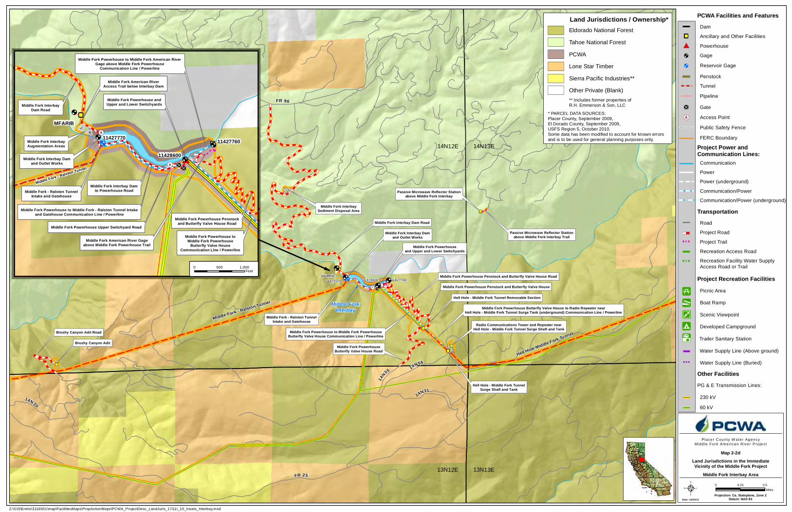
14N55 14N56
11427760
FR 96
11427770
Middle Fork Interbay Dam Road
Passive Microwave Reflector Stationabove Middle Fork Interbay
Middle Fork Interbay Damand Outlet Works
Middle Fork - Ralston TunnelIntake and Gatehouse
Middle Fork Powerhouseand Upper and Lower Switchyards
Middle Fork Powerhouse Penstock and Butterfly Valve House Road
Middle Fork Powerhouse Penstock and Butterfly Valve House
Middle Fork PowerhouseButterfly Valve House Road
Middle Fork Powerhouse to Middle Fork PowerhouseButterfly Valve House Communication Line / Powerline
Middle Fork Powerhouse Butterfly Valve House to Radio Repeater nearHell Hole - Middle Fork Tunnel Surge Tank (underground) Communication Line / Powerline
Hell Hole - Middle Fork TunnelSurge Shaft and Tank
Radio Communications Tower and Repeater nearHell Hole - Middle Fork Tunnel Surge Shaft and Tank
Middle Fork - Ralston Tunnel
Middle Fork InterbaySediment Disposal Area
Hell Hole-Middle Fork Tunnel
Passive Microwave Reflector Stationabove Middle Fork Interbay Trail
11428600
Hell Hole - Middle Fork Tunnel Removable Section
Middle Fork - Ralston Tunnel
Brushy Canyon Adit
Brushy Canyon Adit Road
14N3114N30
FR 2513N12E 13N13E
14N12E 14N13E
MFARIB
FR 96
Hell Hole - Middle Fork Tunnel
Middle ForkInterbay
Date: 10/20/11Projection: Ca. Stateplane, Zone 2
Datum: NAD 83
Place r Cou nty W ater Ag en cyMidd le Fork Amer ica n R ive r P roje ct
0 0.50.25Miles
Z:\GIS\Entrix\3116501\map\FacilitiesMaps\PropActionMaps\PCWA_ProjectDesc_LandJuris_17i11i_10_Insets_Interbay.mxd
11427770
Middle Fork InterbayDam Road
Middle Fork Powerhouse Upper Switchyard Road
Middle Fork Powerhouse to Middle Fork American RiverGage above Middle Fork Powerhouse
Communication Line / Powerline
Middle Fork Powerhouse to Middle Fork - Ralston Tunnel Intakeand Gatehouse Communication Line / Powerline
Middle Fork American River Gageabove Middle Fork Powerhouse Trail
11427760
11428600Middle Fork Interbay Damand Outlet Works
Middle Fork Powerhouse andUpper and Lower Switchyards
Middle Fork - Ralston TunnelIntake and Gatehouse
Middle Fork - Ralston Tunnel
Middle Fork Powerhouse Penstockand Butterfly Valve House Road
Middle Fork Powerhouse toMiddle Fork Powerhouse
Butterfly Valve HouseCommunication Line / Powerline
Middle Fork Interbay Damto Powerhouse Road
MFARIB
Middle Fork American RiverAccess Trail below Interbay Dam
Middle Fork InterbayAugmentation Areas
0 1,000500Feet
168
B
B
B
PCWA Facilities and Features
Project Road
TransportationRoad
Tunnel
Recreation Access Road
Gage
Water Supply Line (Buried)
Project Trail
FERC Boundary
Ancillary and Other Facilities
Powerhouse
Project Power andCommunication Lines:
Penstock
Dam
Gate
Project Recreation FacilitiesPicnic Area
PG & E Transmission Lines:
Boat Ramp
Developed Campground
Scenic Viewpoint
Other Facilities
Communication
Power
Power (underground)
Communication/Power
Communication/Power (underground)
230 kV
60 kV
Access Point
Public Safety Fence
Pipeline
Recreation Facility Water SupplyAccess Road or Trail
Water Supply Line (Above ground)
Reservoir Gage
Trailer Sanitary Station
Land Jurisdictions in the ImmediateVicinity of the Middle Fork Project
Middle Fork Interbay Area
Map 2-2d
* PARCEL DATA SOURCES: Placer County, September 2009,El Dorado County, September 2009,USFS Region 5, October 2010.Some data has been modified to account for known errorsand is to be used for general planning purposes only.
Land Jurisdictions / Ownership*Eldorado National Forest
Tahoe National Forest
Lone Star Timber
PCWA
Sierra Pacific Industries**
Other Private (Blank)** Includes former properties ofR.H. Emmerson & Son, LLC
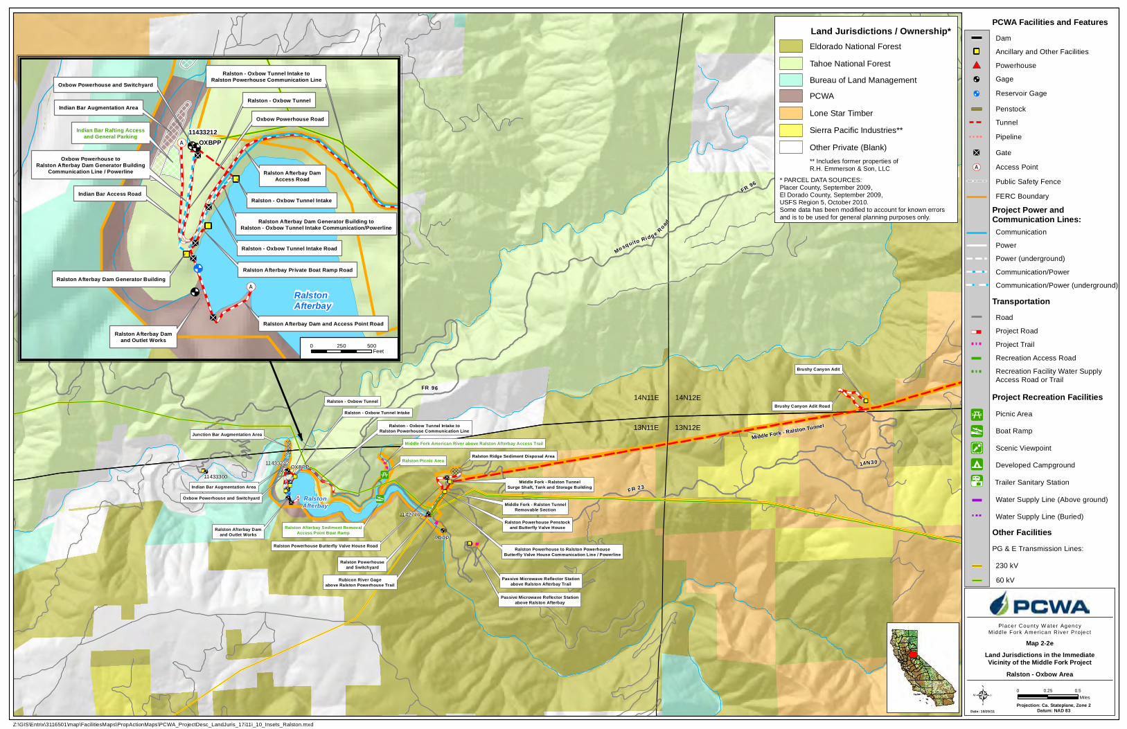
RalstonAfterbay
Ralston - Oxbow Tunnel
Oxbow Powerhouse and Switchyard
Ralston Afterbay Damand Outlet Works
Ralston - Oxbow Tunnel Intake toRalston Powerhouse Communication Line
Ralston Powerhouseand Switchyard
Ralston Powerhouse Penstockand Butterfly Valve House
Passive Microwave Reflector Stationabove Ralston Afterbay
Ralston Powerhouse to Ralston PowerhouseButterfly Valve House Communication Line / Powerline
Middle Fork - Ralston TunnelSurge Shaft, Tank and Storage Building
Ralston Powerhouse Butterfly Valve House Road
Ralston Picnic Area11433212
Passive Microwave Reflector Stationabove Ralston Afterbay Trail
Ralston Ridge Sediment Disposal Area
Ralston - Oxbow Tunnel Intake
Middle Fork - Ralston TunnelRemovable Section
Brushy Canyon Adit
Brushy Canyon Adit Road
14N30
FR 9614N11E 14N12E
13N11E 13N12E
Ralston Afterbay Sediment RemovalAccess Point Boat Ramp
RRRP
OXBPP
Indian Bar Augmentation Area
Junction Bar Augmentation Area
Rubicon River Gageabove Ralston Powerhouse Trail
Middle Fork American River above Ralston Afterbay Access Trail
FR 23
Mosquito Ridg e Road
FR 96
Middle Fork - Ralston Tunnel
11433300
11427765
Date: 10/20/11Projection: Ca. Stateplane, Zone 2
Datum: NAD 83
Place r Cou nty W ater Ag en cyMidd le Fork Amer ica n R ive r P roje ct
0 0.50.25Miles
Z:\GIS\Entrix\3116501\map\FacilitiesMaps\PropActionMaps\PCWA_ProjectDesc_LandJuris_17i11i_10_Insets_Ralston.mxd
11433212
Ralston - Oxbow Tunnel Intake Road
Ralston Afterbay Private Boat Ramp Road
Ralston - Oxbow Tunnel Intake
Oxbow Powerhouse toRalston Afterbay Dam Generator Building
Communication Line / Powerline
Oxbow Powerhouse Road
Ralston Afterbay Dam Generator Building
Ralston Afterbay Dam and Access Point Road
Ralston Afterbay Dam Generator Building toRalston - Oxbow Tunnel Intake Communication/Powerline
Indian Bar Rafting Accessand General Parking
Ralston Afterbay Damand Outlet Works
Oxbow Powerhouse and Switchyard
Ralston - Oxbow Tunnel
RalstonAfterbay
Ralston - Oxbow Tunnel Intake toRalston Powerhouse Communication Line
Indian Bar Access Road
Ralston Afterbay DamAccess Road
Indian Bar Augmentation Area
OXBPP
0 500250Feet
168
B
B
B
PCWA Facilities and Features
Project Road
TransportationRoad
Tunnel
Recreation Access Road
Gage
Water Supply Line (Buried)
Project Trail
FERC Boundary
Ancillary and Other Facilities
Powerhouse
Project Power andCommunication Lines:
Penstock
Dam
Gate
Project Recreation FacilitiesPicnic Area
PG & E Transmission Lines:
Boat Ramp
Developed Campground
Scenic Viewpoint
Other Facilities
Communication
Power
Power (underground)
Communication/Power
Communication/Power (underground)
230 kV
60 kV
Access Point
Public Safety Fence
Pipeline
Recreation Facility Water SupplyAccess Road or Trail
Water Supply Line (Above ground)
Reservoir Gage
Trailer Sanitary Station
Land Jurisdictions in the ImmediateVicinity of the Middle Fork Project
Ralston - Oxbow Area
Map 2-2e
* PARCEL DATA SOURCES: Placer County, September 2009,El Dorado County, September 2009,USFS Region 5, October 2010.Some data has been modified to account for known errorsand is to be used for general planning purposes only.
Land Jurisdictions / Ownership*Eldorado National Forest
Tahoe National Forest
Lone Star Timber
PCWA
Sierra Pacific Industries**
Other Private (Blank)** Includes former properties ofR.H. Emmerson & Son, LLC
Bureau of Land Management
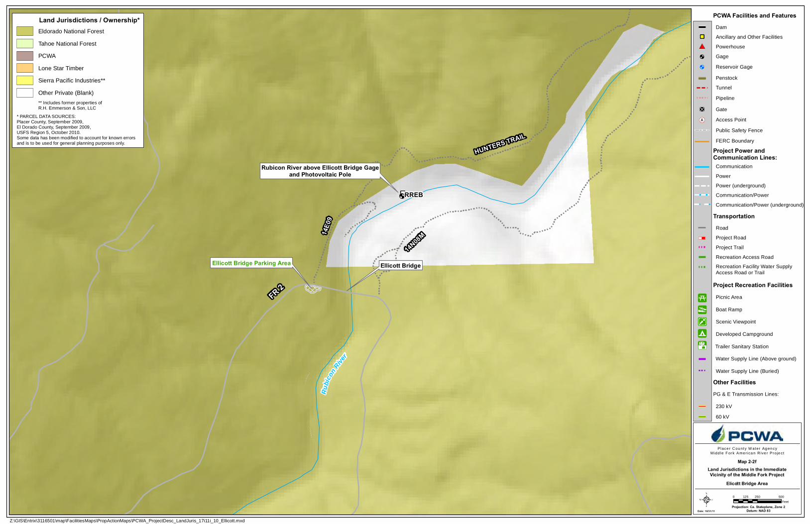
Projection: Ca. Stateplane, Zone 2Datum: NAD 83
RREB
FR 2
14N08M14
E09
Ellicott BridgeEllicott Bridge Parking Area
Rubicon River above Ellicott Bridge Gageand Photovoltaic Pole
Rubic
on Rive
r
HUNTERS TRAIL
Z:\GIS\Entrix\3116501\map\FacilitiesMaps\PropActionMaps\PCWA_ProjectDesc_LandJuris_17i11i_10_Ellicott.mxd
Place r Cou nty W ater Ag en cyMidd le Fork Amer ica n R ive r P roje ct
0 250 500125Feet
Date: 10/31/11
Land Jurisdictions in the ImmediateVicinity of the Middle Fork Project
Map 2-2f
* PARCEL DATA SOURCES: Placer County, September 2009,El Dorado County, September 2009,USFS Region 5, October 2010.Some data has been modified to account for known errorsand is to be used for general planning purposes only.
Land Jurisdictions / Ownership*Eldorado National Forest
Tahoe National Forest
Lone Star Timber
PCWA
Sierra Pacific Industries**
Other Private (Blank)** Includes former properties ofR.H. Emmerson & Son, LLC
Elicott Bridge Area
PCWA Facilities and Features
Project Road
TransportationRoad
Tunnel
Recreation Access Road
Gage
Water Supply Line (Buried)
Project Trail
FERC Boundary
Ancillary and Other Facilities
Powerhouse
Project Power andCommunication Lines:
Penstock
Dam
Gate
Project Recreation FacilitiesPicnic Area
PG & E Transmission Lines:
Boat Ramp
Developed Campground
Scenic Viewpoint
Other Facilities
Communication
Power
Power (underground)
Communication/Power
Communication/Power (underground)
230 kV
60 kV
Access Point
Public Safety Fence
Pipeline
Recreation Facility Water SupplyAccess Road or Trail
Water Supply Line (Above ground)
Reservoir Gage
Trailer Sanitary Station
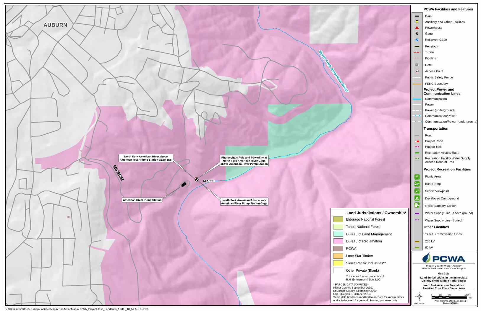
Date: 10/31/11Projection: Ca. Stateplane, Zone 2
Datum: NAD 83
NFARPS
North Fork American River aboveAmerican River Pump Station Gage
North Fork American River aboveAmerican River Pump Station Gage Trail Photovoltaic Pole and Powerline at
North Fork American River Gageabove American River Pump Station
American River Pump Station
AUBURN
DALE DRIVE
North Fork American River
Z:\GIS\Entrix\3116501\map\FacilitiesMaps\PropActionMaps\PCWA_ProjectDesc_LandJuris_17i11i_10_NFARPS.mxd
Place r Cou nty W ater Ag en cyMidd le Fork Amer ica n R ive r P roje ct
0 500 1,000250Feet
PCWA Facilities and Features
Project Road
TransportationRoad
Tunnel
Recreation Access Road
Gage
Water Supply Line (Buried)
Project Trail
FERC Boundary
Ancillary and Other Facilities
Powerhouse
Project Power andCommunication Lines:
Penstock
Dam
Gate
Project Recreation FacilitiesPicnic Area
PG & E Transmission Lines:
Boat Ramp
Developed Campground
Scenic Viewpoint
Other Facilities
Communication
Power
Power (underground)
Communication/Power
Communication/Power (underground)
230 kV
60 kV
Access Point
Public Safety Fence
Pipeline
Recreation Facility Water SupplyAccess Road or Trail
Water Supply Line (Above ground)
Reservoir Gage
Trailer Sanitary Station
Land Jurisdictions in the ImmediateVicinity of the Middle Fork Project
Map 2-2g
North Fork American River aboveAmerican River Pump Station Area
* PARCEL DATA SOURCES: Placer County, September 2009,El Dorado County, September 2009,USFS Region 5, October 2010.Some data has been modified to account for known errorsand is to be used for general planning purposes only.
Land Jurisdictions / Ownership*Eldorado National Forest
Tahoe National Forest
Lone Star Timber
PCWA
Sierra Pacific Industries**
Other Private (Blank)** Includes former properties ofR.H. Emmerson & Son, LLC
Bureau of Land Management
Bureau of Reclamation