Embed Size (px)
Citation preview

Arizona Geological Surveywww.azgs.az.gov | repository.azgs.az.gov
Contributed report Cr-15-dDecember 2015
Superior, Arizona: An Old Mining Camp with Many Lives
David F. BriggsEconomic Geologist
Concentrator plant at Superior, ca. 2000.

Arizona Geological Survey
M. Lee Allison, State Geologist and Director
Manuscript approved for publication in December 2015Printed by the Arizona Geological Survey
All rights reserved
For an electronic copy of this publication: www.repository.azgs.az.govPrinted copies are on sale at the Arizona Experience Store
416 W. Congress, Tucson, AZ 85701 (520.770.3500)
For information on the mission, objectives or geologic products of the Arizona Geological Survey visit www.azgs.az.gov.
This publication was prepared by an agency of the State of Arizona. The State of Arizona, or any agency thereof, or any of their employees, makes no warranty, ex-pressed or implied, or assumes any legal liability or responsibility for the accuracy,
completeness, or usefulness of any information, apparatus, product, or process disclosed in this report. Any use of trade, product, or firm names in this publication
is for descriptive purposes only and does not imply endorsement by the State of Arizona.
___________________________
Arizona Geological Survey Contributed Report series provides non-AZGS authors with a forum for publishing documents concerning Arizona geology. While review comments may have been incorporated, this document does not necessarily conform to AZGS technical, editorial, or policy standards.
The Arizona Geological Survey issues no warranty, expressed or implied, regarding the suitability of this product for a particular use. Moreover, the Arizona Geological Survey shall not be liable under any circumstances for any direct, indirect, special, incidental, or consequential damages with respect to claims by users of this product.
The author(s) is solely responsible for the data and ideas expressed herein.
Recommended Citation: Briggs, D.F., 2015, Superior, Arizona - An Old Mining Camp with Many Lives. Arizona Geological Survey Contributed Report, CR-15-D, 13 p.

Superior, Arizona - An Old Mining Camp with Many Lives 1
Superior, Arizona - An Old Mining Camp with Many LivesDavid Briggs
Economic [email protected]
In November 1870, General George Stoneman, the mili-tary commander of the Arizona Territory, erected a small military camp near the base of Picket Post Mountain and began construction of a road to the proposed site of Camp Pinal, a second military post in the Pinal Mountains. Completed in April 1871, this road meandered north from Camp Picket Post on Queen Creek about three miles west of the present town site of Superior to a point along Silver King Wash; then followed Silver King Wash north to its junction with Comstock Wash (Figure 1). The road crossed the Pinal Mountains at “Stoneman’s Grade”, where it dropped into the upper reaches of the Queen Creek drain-age before emerging just north of Oak Flat and crossing Devils Canyon before continuing east to Camp Pinal, locat-
ed near the present day community of Top of the World. Shortly after the Camp Grant Massacre of April 30, 1871, General Stoneman was relieved of command and replaced by General George Crook, who subsequently abandoned Camp Pinal in July 1871 (Machula, 1996a). Over the next several years, through both negotiation and military ac-tions, resistance from most of the Apache and Yavapai tribes ceased and by the spring of 1873 the Indians began to settle on their reservations (Machula, 1996b).
Silver King Mine (1875-1920)
In 1873, a soldier named Sullivan, who had been involved in the construction of the road that had become the main route between the Globe area and valleys of the Salt and Gila rivers was returning to camp one evening, when he found several heavy, black nuggets of metallic material near the base of Stoneman’s Grade (Short et al, 1943). Although he had little knowledge of minerals, he figured that he must have found something unusual. He kept the black nuggets and returned to camp without saying any-thing about his discovery to the other soldiers.
A short time later his term of service with the army ex-pired and he began working for a Florence rancher named Charles Mason. He showed the black nuggets to Mason, who recognized them as native silver. However, Sullivan did not return to the location of his discovery before unex-pectedly leaving the Florence area a short time later (Haak, 1991).
Sullivan’s discovery sparked Mason’s interest. He orga-nized a prospecting party to search for the source of the silver specimens in 1874. Although their initial foray into the area failed to locate the source of the nuggets, they did discover a manganese-stained outcrop that later became the Silver Queen Mine (Hammer and Peterson, 1968).
On a later foray, Benjamin Reagan, William Long, Isaac Copeland and Charles Mason were returning home from a prospecting trip to the Globe area and camped out near the base of Stoneman’s Grade. While there they found black silver nuggets that were similar to those Sullivan had shown Mason. They traced the nuggets to their source, which cropped out at the top of a small conical hill, where they staked the Silver King claim on March 22, 1875 (Short et al, 1943). Within six months, 50 miners were working the site, producing very rich, hand-sorted silver ore that assayed as much as $2,000 per ton (about 1,600 ounces of silver per ton or 5.5% silver) and could be shipped directly to a smelter without additional treatment. Direct-smelting ore was hauled by wagon to Florence, where it was treated in a small cupel-type furnace, owned by Cury and Hughes (Short et al, 1943) (Figure 2). In June 1876, a stamp mill and amalgamation plant, designed to treat lower grade,
Figure 1. Historical Landmarks of the Superior Area. The heavy red line represents the surface projection of the Never Sweat Tunnel. The Resolution Copper Deposit also represents a surface projection of the ore body.

Superior, Arizona - An Old Mining Camp with Many Lives2
free-milling ores from the Silver King Mine, were erected near the former military camp at Picket Post along Queen Creek, approximately five miles southwest of the mine site (Figure 3).
The Silver King Mine was sold to Comstock Nevada interests in December 1876 and the Silver King Mining Company was organized in May 1877. The cost of shipping supplies to the site was significantly lowered with the arrival of the Southern Pacific Railroad in Casa Grande from the west coast in May 1879. Picket Post was renamed Pinal City in 1879.
By 1882, much of the free milling silver ores had been mined, necessitating a change in the method of treatment. The ores were initially crushed on-site by a Blake crusher and then transported by wagon to Pinal
City where they were further reduced by a battery of 20-stamps and treated by a gravity circuit composed
of twelve Frue vanners to produce a silver-bearing concentrate product that also contained significant amounts of lead and zinc. These concentrates were shipped to the Dome Mining and Smelting Company in Melrose, California, Selby Works in San Francisco and Omaha Smelting Works (Short et al, 1943).
Successful operations attracted others to the area includ-ing the Windsor Consolidated Company, who treated the ores at an amalgamation plant, which was leased by the Silver King Mining Company in 1884. By 1884, the Silver King Mine had been developed to a depth of 800 feet (Fig-ure 4). Most of the ore was mined from the 700- and 800-foot levels. The last year of profitable operations occurred in 1887, when ore grades averaged 21.08 oz. silver/ton for concentrating ore and 32.47 oz. silver/ton for amalgama-tion ore. Unsuccessful attempts to treat copper-bearing ores from the 800-foot level by lixiviation failed. Milling operations at Pinal City ceased in early 1889 and town site was abandoned soon thereafter (Short et al, 1943).
Over the next two years, exploration failed to find suffi-cient ore to resume production and the mine was closed in January 1891. It was briefly reopened in September 1891 and commercial ore was discovered in a new shaft that was located east of the historic workings. Ten stamps from the closed Pinal City mill were relocated to the Silver King mine site. Although limited production was achieved from this discovery, a decline in the price of silver during early 1893 resulted in the suspension of all operations. A second attempt to resume production was made during the fall of 1895, but also failed, halting all operations at the Silver King mine site in 1896 (Short et al, 1943).
After two decades of inactivity, the Silver King property was acquired by the Silver King of Arizona Mining Com-pany in 1916. The 987-foot main shaft was dewatered and the workings refurbished during 1917. Several small
Figure 2. A wagon train of three ore carts pulled by many mules hauls ore from the Silver King Mine to the Pinal City mill (circa 1880s) (2011-03-4270, ADMMR Photo Archive, Arizona Geological Survey).
Figure 3. Two miners standing in front of a 20-stamp mill at Pinal City (circa 1880s) (2011-030-4253, ADMMR Photo Archive, Arizona Geological Survey).
Figure 4. An overview of the Silver King Mine showing the loading chute, crusher, stacks of lumber and other buildings (circa 1880s) (2011-03-4268, ADMMR Photo Archive, Arizona Geological Survey).
Superior, Arizona - An Old Mining Camp with Many Lives 3
high-grade ore bodies that had been missed by the former operators were mined on the 120-foot level. A 35-ton/day flotation mill was commissioned in late 1918 and com-menced intermittent shipments of silver-bearing concen-trates that assayed 1,000 to 1,980 oz. silver/ton, 20% lead and 7 to 8% copper. In July 1919, a new shaft was collared and sank to a depth of 635 feet, before the Silver King of Arizona Mining Company declared bankruptcy and halted all operations during the summer of 1920 (Short et al, 1943). Last reported production occurred in 1928, when 3,000 ounces of silver is reported to have been recovered from material salvaged from the Silver King mine dumps.
Approximately 6.2 million ounces of silver were recovered over the 45-year life of the Silver King project, including 229,764 ounces of silver from 12,546 tons of ore mined between 1918-1920 (Short et al, 1943).
Silver Queen Mine (1875-1907)
The Hub mining claim was staked by William Tuttle on March 29, 1875 and the Irene claim was staked by Irene Vail of Globe on September 1, 1876. These claims be-came the nucleus of the Silver Queen Mine, which would later become the Magma Mine. Phillip Swain organized the Silver Queen Mining Company in 1880 to develop the silver-bearing vein that cropped out at the site (Short et al, 1943).
Mining activities in the Silver Queen area were initially served by the community of Queen, which was renamed Hastings in 1882. By 1882, this mine included a 400-foot vertical shaft with short cross-cuts to the vein on the 100-, 200-, 300- and 400-foot levels. Only limited amounts of silver ore were encountered in these underground work-ings. The Irene claim was patented on October 31, 1885, while the Hub claim was patented on November 3, 1886 (Short et al, 1943). Operations were suspended at the Sil-ver Queen Mine in 1893, when declining silver prices made the project unprofitable.
The Silver Queen’s copper resource was initially examined by George Andrus in 1906. Encouraged by its potential, he formed the Queen Copper Mining Company. However, a 35% decline in the price of copper due to the Financial Panic of 1907 resulted in the abandonment of this early effort to develop the copper resources at this site (Short et al, 1943).
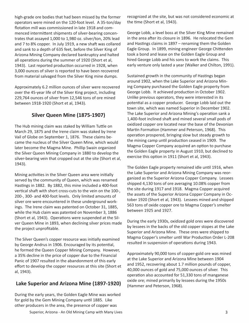
Lake Superior and Arizona Mine (1897-1920)
During the early years, the Golden Eagle Mine was worked for gold by the Gem Mining Company until 1885. Like other producers in the area, the presence of copper was
recognized at the site, but was not considered economic at the time (Short et al, 1943).
George Lobb, a level boss at the Silver King Mine remained in the area after its closure in 1896. He relocated the Gem and Hastings claims in 1897 – renaming them the Golden Eagle Group. In 1899, mining engineer George Chittenden took a bond and lease on the Golden Eagle Group and hired George Lobb and his sons to work the claims. This early venture only lasted a year (Walker and Chilton, 1991).
Sustained growth in the community of Hastings began around 1902, when the Lake Superior and Arizona Min-ing Company purchased the Golden Eagle property from George Lobb. It achieved production in October 1902. Unlike previous operators, they were interested in its potential as a copper producer. George Lobb laid out the town site, which was named Superior in December 1902. The Lake Superior and Arizona Mining’s operation sank a 1,400-foot inclined shaft and mined several small pods of oxidized copper ore located near the base of the Devonian Martin Formation (Hammer and Peterson, 1968). This operation prospered, bringing slow but steady growth to the mining camp until production ceased in 1909. The Magma Copper Company acquired an option to purchase the Golden Eagle property in August 1910, but declined to exercise this option in 1911 (Short et al, 1943).
The Golden Eagle property remained idle until 1916, when the Lake Superior and Arizona Mining Company was reor-ganized as the Superior Arizona Copper Company. Lessees shipped 4,130 tons of ore averaging 10.08% copper from the site during 1917 and 1918. Magma Copper acquired the assets of the Superior Arizona Copper Company in Oc-tober 1920 (Short et al, 1943). Lessees mined and shipped 563 tons of oxide copper ore to Magma Copper’s smelter between 1925 and 1927.
During the early 1930s, oxidized gold ores were discovered by lessees in the backs of the old copper stopes at the Lake Superior and Arizona Mine. These ores were shipped to Magma Copper’s smelter until War Production Order L-208 resulted in suspension of operations during 1943.
Approximately 90,000 tons of copper-gold ore was mined at the Lake Superior and Arizona Mine between 1904 and 1952, recovering about 1.7 million pounds of copper, 40,000 ounces of gold and 75,000 ounces of silver. This operation also accounted for 51,330 tons of manganese oxide ore; mined primarily by lessees during the 1950s (Hammer and Peterson, 1968).
Superior, Arizona - An Old Mining Camp with Many Lives4
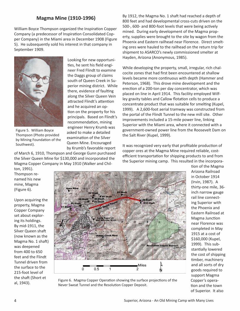
Magma Mine (1910-1996)
William Boyce Thompson organized the Inspiration Copper Company (a predecessor of Inspiration Consolidated Cop-per Company) in the Miami area in December 1908 (Figure 5). He subsequently sold his interest in that company in September 1909.
Looking for new opportuni-ties, he sent his field engi-neer Fred Flindt to examine the Daggs group of claims south of Queen Creek in Su-perior mining district. While there, evidence of faulting along the Silver Queen Vein attracted Flindt’s attention and he acquired an op-tion on the property for his principals. Based on Flindt’s recommendation, mining engineer Henry Krumb was asked to make a detailed examination of the Silver Queen Mine. Encouraged by Krumb’s favorable report
of March 6, 1910, Thompson and George Gunn purchased the Silver Queen Mine for $130,000 and incorporated the Magma Copper Company in May 1910 (Walker and Chil-ton, 1991). Thompson re-named his new mine, Magma (Figure 6).
Upon acquiring the property, Magma Copper Company set about explor-ing its holdings. By mid-1911, the Silver Queen shaft (now known as the Magma No. 1 shaft) was deepened from 400 to 650 feet and the Flindt Tunnel driven from the surface to the 215-foot level of the shaft (Short et al, 1943).
By 1912, the Magma No. 1 shaft had reached a depth of 800 feet and had developmental cross-cuts driven on the 500-, 600- and 800-foot levels that were being actively mined. During early development of the Magma prop-erty, supplies were brought to the site by wagon from the Phoenix and Eastern railhead near Florence. Direct smelt-ing ores were hauled to the railhead on the return trip for shipment to ASARCO’s newly commissioned smelter at Hayden, Arizona (Anonymous, 1985).
While developing the property, small, irregular, rich chal-cocite zones that had first been encountered at shallow levels became more continuous with depth (Hammer and Peterson, 1968). This drove mine development and the erection of a 200-ton per day concentrator, which was placed on line in April 1914. This facility employed Wilf-ley gravity tables and Callow flotation cells to produce a concentrate product that was suitable for smelting (Kupel, 1999). A 2,600-foot aerial tramway was constructed from the portal of the Flindt Tunnel to the new mill site. Other improvements included a 15-mile power line, linking Superior with the Miami area, where it connected with a government-owned power line from the Roosevelt Dam on the Salt River (Kupel, 1999).
It was recognized very early that profitable production of copper ores at the Magma Mine required reliable, cost-efficient transportation for shipping products to and from the Superior mining camp. This resulted in the incorpora-
tion of the Magma Arizona Railroad in October 1914 (Irvin, 1987). A thirty-one mile, 36-inch narrow gauge rail line connect-ing Superior with the Phoenix and Eastern Railroad at Magma Junction near Florence was completed in May 1915 at a cost of $160,000 (Kupel, 1999). This sub-stantially lowered the cost of shipping timber, machinery and all sorts of dry goods required to support Magma Copper’s opera-tion and the town of Superior. It also
Figure 5. William Boyce Thompson (Photo provided by Mining Foundation of the Southwest).
Figure 6. Magma Copper Operation showing the surface projections of the Never Sweat Tunnel and the Resolution Copper Deposit.

Superior, Arizona - An Old Mining Camp with Many Lives 5
provided the means for the outbound shipment of copper concentrates to the Hayden smelter (Figure 7).
Located 400 feet north of the No. 1 shaft, the No. 2 shaft was sunk from the 215-foot level of the Flindt Tunnel in 1915, reaching the 1,500-foot level in 1916, where it encountered the Magma Vein. Mineralized from wall to wall at that point, this high-grade zone was 34-feet thick and averaged 10.52% copper, 5.37 oz/ton silver and 1.26 oz/ton gold. As a result of this discovery and with the increased demand for copper from the war in Europe, Magma Copper increased the capacity of its concentrator to 300 tons/day (Short et al, 1943).
The discovery of a major ore body on the 1,500-foot level began to tax the hoisting capacity of the No. 2 shaft. By the time the No. 2 shaft reached the 1,800-foot level in 1917, mine officials decided the hoisting capacity needed to be expanded. Located about 400 feet south of the No. 1 shaft, the No. 3 shaft was collared in late 1917 (Kupel, 1999). A 600-kw power transmission line from Goldfield was added in 1918 to supplement the Miami line.
Despite falling copper prices following the end of World War I in November 1918, Magma Copper completed sink-ing the No. 2 and No. 3 shafts to the 2,000-foot level in 1919. They also drove the Main Tunnel (500-foot level) from the surface to both of these shafts, significantly reducing the cost of hoisting the ore to the Flindt Tunnel (Short, et al, 1943). The No. 4 shaft was collared east of the existing workings in 1920 for use as an exhaust shaft in an effort to improve the ventilation within the hot under-ground workings.
By 1921, copper prices had fallen to 14.7 cents/lb. In response to the decreased demand Magma Copper tem-porarily suspended ore production in March of that year.
However, they continued development work, completing the No. 2 shaft to a depth of 2,450 feet (Short, et al, 1943). Encouraged by the presence of high grade ore at this depth, Magma Copper sought ways to reduce its operating costs. Results of a feasibility study demonstrated in-house smelting and a standard gauge rail line would reduce operating costs by 2 cents/lb of copper recovered (Rickard, 1987).
Having decided to proceed with this expansion project, Magma Copper issued $3.6 million in bonds to finance its construction in early 1922 (Walker and Chilton, 1991). The rail line was converted to standard gauge during the spring of 1922. The concentrator remained closed during 1922 and its capacity was expanded to 600 tons/day. Work on the smelter commenced in December 1922 and limited milling of ore resumed during 1923. Magma Copper’s new smelter was commissioned on March 29, 1924 at a total cost of about $1.9 million (Figure 8), allowing the mine to resume full production (Rickard, 1987). The efficiency of the operation was increased by this expansion program, lowering production costs to 7.51 cents/lb of copper recovered (Short et al, 1943). Magma Copper became the first mining company in Arizona to offer life insurance to its employees in 1925.
Further improvements to infrastructure included replace-ment of the aerial tramway with a surface rail system that connected the Main Level portal of the mine with the mill in 1926. Located about 2,400 feet southwest of the No. 3 shaft, the No. 5 shaft was collared in 1926. The West ore body was discovered at a depth of 2,150 feet in 1927 (Short et al, 1943).
The West ore body of the Magma Vein is located between the north trending Main Fault and the northwest-striking Concentrator Fault in the western portion of the mine.
Figure 7. Railroad infrastructure serving Superior mining district.
Figure 8. Superior Smelter looking northwest (August 2009).

Superior, Arizona - An Old Mining Camp with Many Lives6
The Main and Central ore bodies of the Magma Vein are confined to the eastern footwall of the Main Fault (Ham-mer and Peterson, 1968).
A deadly fire in the No. 2 shaft of the Magma Mine claimed the lives of seven miners on November 24, 1927. A second fire broke out in the No. 1 shaft on November 27, 1927. Both shafts were heavily damaged. The No. 1 shaft was abandoned after it caved in after the fire. However, the No. 2 shaft was repaired and placed back into service dur-ing 1928 (Kupel, 1999).
With the development of the No. 5 shaft, which reached the 2,960-foot level in 1928, the large new mining area in the western portion of the operation was beginning to tax the capacity of its ventilation system. To solve this problem the No. 6 shaft was sunk 4,500 feet east of the No. 3 shaft in early 1929, improving air flow in the eastern portion of the mine. The No. 7 shaft was collared approxi-mately 500 feet west of the concentrator later that year. This greatly improved the ventilation in the western por-tion of Magma’s underground workings (Kupel, 1999).
With the crash of the stock market in October 1929, the price of copper fell from 18.2 cents/lb. in 1929 to a low of 6.15 cents/lb. in 1932. In response to the declining price of copper, Magma Copper cut production during the fall of 1930. Reduced production schedules continued until 1936, when conditions improved. With the price of copper reaching 12.04 cents/lb in 1937, Magma Copper began plans to develop the West ore body, which had been dis-covered a decade earlier. However, continued expansion of the operation required finding a solution to the high temperatures that were encountered in the deeper levels of the mine (Kupel, 1999).
Table 1. Rock Temperatures in the Western and Central Portions of the Magma Mine (Short et al, 1943)
Level Degrees F. Level Degrees F. 2,000 109 4,000 140 2,250 112.5 4,200 143 2,550 116 4,400 146 2,800 120 4,600 149 3,000 124 4,800 152 3,200 127
Note: Mine levels of the Magma Mine represent the depth below the collar of the Magma No. 1 shaft, which is located at an elevation of 3,534 feet. Temperatures in the eastern portion of the mine were 140 degrees F. on the 3,400 level and more than 150 degrees F. on the 4,000 level (Dorey, 1992).
As Magma Copper’s operation reached greater depths, temperatures of the rock continued to increase. By the early 1930s, the No. 5 shaft had reached a depth of 3,200 feet, where the rock temperatures exceeded 126 degrees F. Under these conditions, it required several years of ventilation to reduce the temperature in the underground workings to a point allowing safe working conditions for the miners. Willis H. Carrier installed air conditioning units in the lowest working levels (3,400 and 3,600-feet) of the operation in July 1937, lowering temperatures (Short et al, 1943). This innovation was supplemented by the construc-tion of a regenerative cooling tower at the surface in 1947.
The No. 8 shaft was collared between the No. 5 and No. 3 shafts in 1935 and natural gas replaced fuel oil at the smelter in January 1936. Other improvements included the addition of a 250-stpd capacity zinc flotation circuit at the concentrator in 1937. Mining methods at this time employed a system of square-set timbered stopes that were backfilled with mine waste (Figure 9). The Koerner Vein was discovered on the 4,000-foot level in January 1940, further extending the life of the operation (Short et al, 1943).
Figure 9. Miner operating a slusher at the Magma Mine (date unknown) (Photo provided by Magma Copper Company). Slushers are essentially a double-drum hoist attached to a scraper by a system of pulleys and cables that are employed to pull rock away from the mine face so it could be more easily loaded into ore cars.

Superior, Arizona - An Old Mining Camp with Many Lives 7
With the prospects of war looming during the late 1930s, production steadily increased, but Magma Copper contin-ued to operate with a summer shutdown through 1941 due to erratic copper prices, which fluctuated between 10 and 12 cents per pound. With America’s entrance into the war in December 1941, Magma Copper operated at full capacity throughout the war. However, the military draft and competition from defense plants made it necessary to train inexperienced help to achieve Magma Copper’s wartime production goals. Recovery of a zinc by-product was discontinued in July 1945.
As World War II came to a close, Magma Copper’s original concentrator was nearing the end of its productive life. It was replaced by a new 1,500-ton per day facility in 1946. While attempting to locate an offset portion of the Magma Vein east of a north trending fault zone, underground ex-ploration drilling below the 2,550-foot level in the east end of the mine encountered manto-style replacement ores near the base of the Devonian Martin Formation in 1948. This zone became the A-bed ore body (Hammer, 2015).
Unlike the steeply dipping, east-striking Magma Vein, which cuts across the lower portion of the east-dipping Precambrian and Paleozoic stratigraphic section in the central and western portions of the mine, the widespread, conformable, manto-style ores of the A-bed are character-ized by five distinct, irregular tongue-like bodies composed of chalcopyrite, bornite, hematite, quartz and calcite that preferentially replace a favorable dolomitic bed near the base of the Devonian Martin Formation. Striking north and dipping about 30 degrees to the east, these ore bod-ies measured up to 900 feet along strike, extended up to 4,400 feet down dip and averaged about 15 feet in thick-ness (Paul and Knight, 1995).
Recovery of zinc from copper-zinc vein ores above the 2,250-foot level briefly resumed in July 1950 due to increased demand that resulted from the onset of the Korean War. Production of zinc was suspended in August 1952 owing to the depletion of the remaining copper-zinc reserves. Production of replacement ores from the newly discovered A-bed commenced in 1953, while extraction of ores from the Koerner Vein ceased in 1957. As production was phased out in the western and central portions of the Magma mining operation, replacement ores in the eastern portion of the mine were developed and brought on line, using both square-set and undercut-and-fill mining meth-ods. Mining of the Magma Vein in the western portion of the mine that was accessed by the No. 5 shaft ceased in 1961. Mining of the Magma Vein in the central portion of the mine was suspended in 1966 (Kupel, 1999).
During the late 1950s and early 1960s, the Magma Copper Company consolidated mining properties in the Superior mining district with its purchase of the Magma Apex Cop-per Company in August 1957, the Queen Creek Copper Company in June 1958 and the Belmont Mining Company in April 1961 (Walker and Chilton, 1991).
Four additional manto-style, replacement ore bodies (known as the B, C, D and E beds) were discovered in 1965. Less widespread than the ores of the A- bed, these re-placement bodies are restricted to the immediate footwall of the North Boundary Fault. The B-bed is hosted by carbonate horizons near the top of Devonian Martin For-mation, which is marked by a thinly laminated limestone, locally known as the “Last Black Shale.” The thickest of the replacement bodies (up to 150 feet) is the C-bed, which is hosted by a limestone horizon located about 30 feet above the base of Escabrosa Limestone. The D-bed is located at the top of the Escabrosa Limestone, while the E-bed is hosted by the first carbonate horizon above the maroon shale at the base of the Pennsylvanian-Permian Naco Group (Paul and Knight, 1995).
The Newmont Mining Corporation, founded by William Boyce Thompson in 1916, increased its equity interest in the Magma Copper Company from 21.5% to 80.6% in May 1962. Newmont then acquired the remaining shares in May 1969, making Magma Copper a wholly-owned subsid-iary (Newmont Mining Corporation, 1970).
The high costs of developing and mining the replacement ores in the eastern portion of the Magma Mine resulted in the decision to expand the operation’s infrastructure in an effort to reduce production costs. This four-year expan-sion program began in 1969. It included an increase in the concentrator’s capacity from 1,500 to 3,300 tons per day in 1971, construction of the east plant site, the sinking of the 4,843-foot, Magma No. 9 shaft, and driving the 9,700-foot Never Sweat Tunnel on the 500-foot level from the west plant site to the No. 9 shaft (Figure 10). This project was completed in August 1973 at an estimated cost of $74.8 million (Newmont Mining Corporation, 1973).
As a part of these cost reduction measures, a decision was made to close the Superior smelter. Following its closure in July 1971, copper concentrates from the Magma opera-tion were shipped to the larger Magma Copper Company smelter at San Manuel, Arizona.
In May 1982, the failure of temporary ground support resulted in a cave-in that cost four miners their lives. After 71 years of production the Magma Copper Company ceased mining and milling operations at its Superior opera-tion in August 1982 due to high operating costs and declin-

Superior, Arizona - An Old Mining Camp with Many Lives8
ing copper prices that fell to 73 cents/lb in 1982 (Magma Copper Company, 1991). The underground mine workings were allowed to flood to the 3,000-foot level after care and maintenance operations were suspended in 1985 (Dorsey, 1992).
In March 1987, Newmont Mining Corporation combined the assets of its wholly-owned, Arizona copper subsidiar-ies into a new public company, and spun-off a new Magma Copper Company, distributing Magma’s equity to New-mont shareholders (Newmont Mining Corporation, 1987). Magma Copper became a company in which Newmont owned 15% of its common shares. It was a stand-alone copper company under new management.
With the rising copper prices during the late 1980s, the new Magma Copper Company re-evaluated its operation at Superior and determined the recent increase in the price of copper had transformed approximately 4.4 mil-lion tons of resource at its closure in 1982 into a mineable reserve (Hammer, 2015). They commenced dewatering the Magma Mine in late 1989, lowering the water level to the 3,600-foot level by July 1990. Commercial operations resumed in September 1990 (Kupel, 1999). However, min-ing operations were temporarily halted by a fire in Novem-ber 1991. Four miners lost their lives, while attempting to clear an ore pass in August 1993.
Broken Hill Proprietary Company Ltd. (BHP) acquired the Superior operation through its merger with the Magma Copper Company in January 1996, forming wholly-owned subsidiary BHP Copper, Inc. All operations at Superior were suspended on June 28, 1996 after depleting its re-maining mineable reserves (Broken Hill Proprietary Com-pany Ltd., 1996).
Over the 86-year life of Magma Copper’s Superior proj-ect (1911-1996), approximately 27.6 million short tons of ore averaging about 4.9% copper were mined, recovering 1,299,718 short tons of copper, 36,550 short tons of zinc, approximately 686,000 ounces of gold and 34.3 million ounces of silver.
Approximately 58% of the ore was mined from the manto-style replacement bodies, while 42% was derived from vein deposits. Average head grades of the manto-style and vein deposits was approximately 4.5% and 5.4% copper, respec-tively (Briggs, 2006).
Deep Exploration Efforts at the Magma Mine (1959-1998)
Exploration and development of A-bed replacement ore bodies at the Magma Mine during the 1950s resulted in the discovery of the east-northeast-trending North Boundary Fault in 1959. This major, previously unknown structure dropped strata in its southern wall by at least 3,000 feet (Paul and Manske, 2005) (Figure 11). Entirely concealed by post-mineral cover, the North Boundary Fault juxtaposes Cretaceous volcanoclastic and epiclastic sedi-mentary rocks in its southern wall against Precambrian and Paleozoic sedimentary strata and diabase in its northern wall. Furthermore, this structure is locally mineralized, strongly suggesting it served as the conduit for the miner-alizing solutions that formed the manto-style replacement ore bodies in its northern wall.
Although evidence for a porphyry copper target had been recognized in the area under the volcanic plateau north-east of the Belmont Mine as early as 1972, Magma Copper confined its exploration efforts over the next decade to the search for additional vein and replacement deposits because no known porphyry copper deposits in this region would be economic at the depths indicated at Superior (Hammer, 1972).
One of the exploration targets during the 1970s was the Paleozoic section located in the southern wall of the hypothetical South Boundary Fault, which was thought to be a good candidate to host replacement ores similar to those being mined adjacent to the North Boundary Fault. Although underground exploration of the Cretaceous strata within the downthrown structural block south of the Magma No. 9 shaft failed to confirm this hypothesis, it re-sulted in the discovery of the First South Vein in 1971 and Second South Vein in 1976-1977.
A surface exploration program designed to search for the hypothetical South Boundary Fault focused its atten-tion on the mineralized veins and carbonate rocks that
Figure 10. Entrance to Never Sweat Tunnel with ventilation system (June 2015).

Superior, Arizona - An Old Mining Camp with Many Lives 9
crop out at the Belmont Mine, located about 10,000 feet south of the Magma Vein. This work included surface geologic mapping, geophysical surveys and sampling of the east-trending veins that crop out below Apache Leap, as well as surface drill holes designed to test favorable carbonate replacement horizons south of the presumed location of the south boundary structure. Five drill holes designed to test favorable stratigraphic horizons east of the Belmont Mine and beneath the post-mineral volcanic cover on the plateau were completed between 1973 and 1981. Although this program confirmed the presence of narrow manganese oxide veins and oxidized replacement horizons within the Paleozoic strata, no economic mineral-ization was found.
Exploration proposals that included a north-south fence of surface drill holes designed to bracket the southern bound-ary of the Cretaceous volcanoclastic sediments were made in 1976, 1979 and again in 1980. However, funding for these exploration proposals was not approved (Hammer, 2015). With the closure of the Magma Mine in August
1982, all exploration activities ceased.
After the Magma Mine resumed production in Septem-ber 1990, exploration efforts renewed in two areas. Like earlier exploration programs, the underground program focused its search for additional vein and replacement ores that could be easily incorporated into the Magma mine plan. Magma Copper resumed its earlier efforts to bracket the hypothetical South Bound-ary Fault and the examination of the mineral potential of its southern footwall. As a part of this exploration program, a north-south fence of four deep surface drill holes was proposed to examine the area south of the No. 9 shaft.
The first drill hole (MB-9) of this surface program was collared about 6,300 feet south-southeast of the No. 9 shaft in September 1991 and completed to a depth of 3,267 feet in January 1992 (Sell, 1995). The bot-tom 612 feet of this drill hole encountered pre-mineral Cretaceous volcanoclastics beneath the post-mineral
Figure 11. Schematic Exploration Activities Map - Shows Surface Projections of Geological Units, Important Faults, Resolution Copper Deposit, Never Sweat Tunnel, 3600-Foot Level of Underground Mine and Underground Drill Hole S27E that are concealed beneath post-mineral Tertiary Volcanics. U = Up Thrown, D = Down Thrown.

Superior, Arizona - An Old Mining Camp with Many Lives10
cover that were altered to a sericite-pyrite assemblage with supergene chalcocite coating the pyrite. Collared about 1,400 feet south of MB-9, drill hole MB-11 also encountered similarly altered and mineralized Cretaceous volcanoclastics in July 1992. Although not considered ore, Magma geologists recognized this altered and mineral-ized rock as clear evidence of a porphyry copper system (Sander, 1992).
After a 33-year search, the South Boundary Fault that forms the southern limit of this structurally down-thrown fault block of Cretaceous volcanoclastics was finally discov-ered during the summer of 1992 (Paul and Manske, 2005 and Sell, 1995). Later drilling delineated this structure dur-ing 1995, confirming earlier studies that showed it had also served as a conduit for ore-bearing solutions. Although oxidized manto-type replacement bodies were also en-countered in the Paleozoic strata located in the south wall of this structure, no economic mineralization was identi-fied at this time.
By the summer of 1994, the focus of Magma Copper’s exploration program changed from one of defining re-serves to sustain production to one of identifying new resources that could sustain production while ores along the Southern Boundary Fault could be defined and devel-oped. In October 1994, a sub-horizontal drill hole (S27E) was collared at sea level and directed southward from the southernmost underground workings in the Magma Mine below the bottom of surface drill hole MB-9, which had been completed in January 1992. Completed in February 1995, this 3,648-foot underground drill hole encountered a 1,575-foot interval of pervasive quartz-sericite-pyrite altered Cretaceous volcanoclastics, which assayed 0.56% copper, marking the geologic discovery of the Magma por-phyry copper system at Superior (Paul and Manske, 2005).
In July 1995 a comprehensive exploration program was ap-proved to explore various targets related to this porphyry system, including high grade veins (e.g. Black Beauty Vein), moderate-grade stringer zones, classic porphyry copper stockwork, secondary enrichment blanket and mineralized skarn (Paul and Manske, 2005). Underground drill hole S27H bottomed in a zone of sec-ondary biotite alteration with stockwork chalcopyrite-mo-lybdenite veining that assayed 1.95% copper and 0.036% molybdenum over an interval of 141 feet. This intercept represents the economic discovery of the Magma porphyry copper system at Superior that was later renamed the Resolution copper deposit. At the conclusion of this effort, it was decided to de-emphasize their search for high-grade veins, skarns, stringer zones and targets associated with South Boundary Fault. Future efforts would be focused on
examining the area’s bulk-tonnage porphyry copper poten-tial (Paul and Manske, 2005).
Following Magma Copper’s merger with BHP in January 1996, BHP Copper completed two additional underground drill holes and two deep surface drill holes that encoun-tered significant intercepts of porphyry style mineralization containing more than 1% copper, including one surface hole (MB-20A) at the site of drill hole MB-9 that intersect-ed 1,004 feet of skarn, which assayed 1.75% copper and 0.029% molybdenum (Hehnke et al, 2012).
Despite these high-grade intercepts at its Magma por-phyry copper target, BHP Copper decided to abandon the Magma Mine in May 1998, again allowing its underground workings to flood. It appears the decision to abandon the Magma Mine was based on a number of factors including: a falling copper price ($0.785/lb); limited data on a partial-ly defined deep resource (4,900 to 7,000 feet); lack of suit-able infrastructure to exploit this resource; and on-going costs related to maintaining the project (Seedorff, 1998).
Resolution Copper (2000-present)
Learning of this high grade, but deep discovery, Kennecott Exploration, a wholly-owned subsidiary of Rio Tinto, be-came interested in the Superior mining district in Septem-ber 2000 (Krahulec, 2015). Following completion of a due diligence program, they entered into an agreement with Broken Hill Proprietary Company Ltd. in April 2001 that al-lowed them to earn a 55% interest in the Superior project by spending US $25 million over the next six years. Broken Hill Proprietary Company Ltd. and Billiton plc merged to form BHP Billiton in June 2001. In July 2001, Kennecott commenced a deep exploration drilling program that was designed to outline the porphyry copper discovery at Su-perior, which underlies approximately 3,000 to 4,600 feet of barren post-mineral cover.
As a cost-savings measure, this program employed large mud-rotary drill rigs to drill and case the holes to a depth of approximately 3,300 feet. Then the core sampling of the mineralized zone below began. After completing a vertical core hole beneath each pre-collared mother hole, directional drilling techniques were employed to drill a multiple radiating pattern of daughter holes from each mother hole. By January 2003, this exploration effort had established continuity of mineralization over an area mea-suring at least 3,300 feet in diameter.
In March 2004, Rio Tinto earned its 55% interest in the Superior property and officially assumed control as opera-tor in May 2004. The joint venture partners, Rio Tinto and BHP Billiton formed Resolution Copper Mining LLC to

Superior, Arizona - An Old Mining Camp with Many Lives 11
evaluate, design, permit, construct and operate its project at Superior, Arizona (Figure 12).
Studies were conducted to evaluate the feasibility of employing block-caving techniques at this site in 2002 and 2005. Then an in-fill delineation drilling program resumed to gain a better understanding of the geology, distribution of the mineralization and geotechnical character of this deep porphyry copper system. As of January 2012, 76 core holes had been completed from 16 drill sites (Hehnke et al, 2012).
Centered approximately 4,700 feet southeast of the Mag-ma No. 9 shaft, this high-grade porphyry copper resource apexes at a depth of approximately 4,900 feet, covers an area of approximately 400 acres and ranges up to 2,000 feet in thickness. In December 31, 2014, it was reported to contain an inferred resource of 1.947 billion short tons, averaging 1.51% copper and 0.035% molybdenum, based on classification criteria published by the Australian Joint Ore Reserves Committee (JORC) (Rio Tinto, 2015).
In preparation of sinking the No. 10 shaft, underground work was initiated to rehabilitate and extend the Never Sweat Tunnel in September 2006. Pumping water from the underground mine workings, which had been aban-doned since May 1998, commenced in March 2009. This discharge is treated at a state-of-the-art water treatment plant prior to being delivered to the New Magma Irriga-tion and Drainage District, where it is blended with Central Arizona Project water and used to irrigate alfalfa, cotton, turf and small grains (Resolution Copper, 2013).
Development of the No. 10 shaft, located immediately south of the No. 9 shaft at the East Plant site, began in Feb-ruary 2007 with the construction of the collar set up. The actual sinking of this 28-foot diameter shaft commenced in January 2009. It was completed to a depth of 6,943 feet on November 18, 2014, making it the deepest single-
lift shaft in the United States. With the Resolution copper project currently in the prefeasibility stage, the successful sinking of the No. 10 shaft enables the project to more ef-ficiently advance to final completion (Anonymous, 2014).
Epilogue
Like many mining camps of the western United States, the Superior mining district has had several lives. Early pros-pectors at this once remote locality focused their inter-est on rich, near-surface, silver ores, ignoring the area’s obvious copper potential because of the costly support facilities required for base metals production. Once the silver boom waned and then expired, better financed min-ing interests slowly redirected their efforts to develop the area’s copper resources. This endeavor required consid-erably more infrastructure including reliable rail service that linked the remote mining camp of Superior with the outside world.
Over the half century between 1910 and 1960, production at Superior was primarily derived from high-grade cop-per veins in the Magma Mine. During the late 1940s, rich carbonate-hosted replacement deposits were discovered in the eastern part of the Magma Mine. Prior to 1966, these rich replacement ores gradually replaced the veins as the source for the district’s copper production. The Magma Mine ceased operations in 1996.
The Superior mining district was given a new breath of life in 1995, when exploration efforts, based on data that had been gathered over more than a century, once again bore the fruit of success with the discovery of the Resolu-tion deposit, one of the largest and richest disseminated copper deposits found in North America since 1900. With the successful development of this deep resource,
Figure 12. Exploration Drilling at Resolution (Photo provided by Resolution Copper).
Figure 13. No. 10 (left) and No. 9 Shaft (right) at East Plant Site looking west (June 2015).

Superior, Arizona - An Old Mining Camp with Many Lives12
Resolution Copper could supply more than 25% of Ameri-ca’s demand for the red metal over the next 40 years.
Acknowledgments
The author appreciates the very enlightening information gained through discussions with Donald Hammer and Ken Krahulec about historical aspects of the Superior mining district.
Donald Hammer’s knowledge of the Superior mining district was gained through many years of working in the area, where he began his professional career as a geologist in 1958. His contributions made over nearly four decades exploring the area, as an employee of Magma Copper and Newmont and later as a consultant, played a significant role in the discovery of the Resolution Copper deposit in 1995.
Ken Krahulec’s experience in the Superior mining district was gained from his involvement with Kennecott’s due dili-gence program and their early evaluation of the Resolution porphyry copper system.
The author also thanks the Resolution Copper Company and Arizona Geological Survey for the historical photos contained within this article. Cori Hoag, Donald Hammer and Ken Krahulec edited a rough draft of this paper. Their comments have greatly improved its presentation.
References Cited
Anonymous, 1985, Our History is Reviewed Magma’s 75 Years of Growth: Magma Update, v. 1, n. 6, p. 5-8.
Anonymous, 2014, Resolution Copper Mining Completes Deepest Single Lift Shaft in America: Resolution Copper Media Release, November 18, 2014, 2 p.
Briggs, D. F., 2006, Superior: Mining Operations Report: Private Report, 18 p.
Broken Hill Proprietary Company Ltd., 1996, Securities and Exchange Commission Form 20-F for Fiscal Year Ended 5/31/1996: 156 p.
Dorsey, J., 1992, The Reopening of the Magma Mine, Superior, Arizona: Society of Mining, Metallurgy, and Exploration, Inc. Pre-print 92-117, 4 p.
Haak, W., 1991, Arizona’s Silver Belt; in History of Mining in Arizona: J. Michael Canty and Michael N. Greeley (eds.), Mining Club of the Southwest Foundation and American Institute of Mining Engineers Tucson Section, v. 2, Chapter 2, p. 31-46.
Hammer, D. F., 1972, Geologic Investigation of the Superior Area, Pinal County, Arizona: Unpublished Newmont Exploration Ltd. report to Magma Copper Company, 56 p. plus appendices.
Hammer, D. F., 2015, Oral Communication.Hammer, D. F. and Peterson, D. W., 1968, Geology of the Magma
Mine Area, Arizona; in Ore Deposits of the United States, 1933-1967: The Graton-Sales Volume, American Institute of Mining, Metallurgical, and Petroleum Engineers, Inc., v. 2, Chapter 61, p. 1283-1310.
Hehnke, C., Ballantyne, G., Martin, H., Hart, W., Schwarz, A., and Stein, H., 2012, Geology and Exploration Progress at the Resolution Porphyry Cu-Mo Deposit, Arizona; in Geology and Genesis of Major Copper Deposits and Districts of the World: J. W. Hedenquist, M. Harris, and F. Camus (eds.), Society of Economic Geologists, Special Publication 16, Chapter 7, p. 147-166.
Irvin, G. W. 1987, A Sequential History of Arizona Railroad and Mining Development 1864-1920; in History of Mining in Arizona: J. Michael Canty and Michael N. Greeley (eds.), Mining Club of the Southwest Foundation, American Institute of Mining Engineers Tucson Section and Southwestern Minerals Exploration Association, v. 1, Chapter 11, p. 253-278.
Krahulec, K., 2015, Oral Communication.Kupel, D., 1999, Copper Chronicle: Magma Mine, Superior,
Arizona: The Mining History Journal, v. 6, p. 109-122.Machula, P. A., 1996a, History of Superior Region; in East Central
Arizona History: Accessed Internet - November 1, 2015.Machula, P. A., 1996b, Arizona Apache Wars; in East Central
Arizona History: Accessed Internet - November 1, 2015.Magma Copper Company, 1991, Annual Report for 1990: 40 p.Manske, S. L., and Paul, A. H., 2002, Geology of a Major New
Porphyry Copper Center in the Superior (Pioneer) District, Arizona: Economic Geology, v. 97, n. 2, p. 197-220.
Newmont Mining Corporation, 1970, Annual Report for 1969.Newmont Mining Corporation, 1973, Annual Report for 1972.Newmont Mining Corporation, 1987, Annual Report for 1986: 46
p.Paul, A. H., and Knight, M. J., 1995, Replacement Ores in the
Magma Mine, Superior, Arizona; in Porphyry Copper Deposits of the American Cordillera: F. W. Pierce and J. G. Bolm (eds.), Arizona Geological Society Digest 20, p. 366-372.
Paul, A. H., and Manske, S. L., 2005, History of Exploration at the Magma Mine, Superior, Arizona; in Window to the World: H. N. Rhodes, R. C. Steininger, and P. G. Vikre (eds.), Geological Society of Nevada Symposium Proceedings, Reno, Nevada, May 2005, p. 629-638.
Rickard, F. R., 1987, History of Smelting in Arizona; in History of Mining in Arizona: J. Michael Canty and Michael N. Greeley (eds.), Mining Club of the Southwest Foundation, American Institute of Mining Engineers Tucson Section and Southwestern Minerals Exploration Association, v. 1, Chapter 9, p. 191-228.
Resolution Copper Company, 2013, Resolution Copper Mine Dewatering Project, Superior and Queen Creek, Arizona: Resolution Copper Fact Sheets, October 2013, 2 p.
Rio Tinto, 2015, 2014 Annual Report, 232 p.Sander, Mark, 1992, Oral Communication.Seedorff, E., 1998, Public Information of the Magma Porphyry
Deposit, Superior District, Arizona: BHP Copper Memorandum, April 27, 1998, 2 p.
Sell, J. D., 1995, Discovery of a Deep (3,500 feet) Unexposed Porphyry Copper Deposit at Superior East, Pinal County, Arizona; in Porphyry Copper Deposits of the American

Superior, Arizona - An Old Mining Camp with Many Lives 13
Cordillera: F. W. Pierce and J. G. Bolm (eds.), Arizona Geological Society Digest 20, p. 373-395.
Short, M. N., Galbraith, F. W., Harshman, E. N., Kuhn, T. H., and Wilson, E. D., 1943, Geology and Ore Deposits of the Superior Mining Area, Arizona: Arizona Bureau of Mines Geological Series, v 16, n. 151, 159 p.
Walker, G., and Chilton, T. G., 1991, The History of Mining at Superior; in History of Mining in Arizona: J. Michael Canty and Michael N. Greeley (eds.), Mining Club of the Southwest Foundation and American Institute of Mining Engineers Tucson Section, v. 2, Chapter 9, p. 231-260.