Embed Size (px)
Citation preview
i
SUMMER INTERNSHIP (TRAINING) REPORT
At NAGPUR IMPROVEMENT TRUST,
‘NAGPUR METROPOLITAN AREA’ DIVISION
-SUBMMITED BY
AKSHAY R. PATIL
111214035
T.Y. B.TECH PLANNING
COLLEGE OF ENGINEERING PUNE

i
MEMORANDUM
This report has been written to provide information about the summer internship which was done by Akshay R. Patil in Nagpur improvement Trust. The aims of this summer internship are to understand the Exposure of Live Planning Projects and Working Environment in Planning Organization or in development authority. And objectives are to participate in a Live Project of Planning Office / Planning Authority, to understand the profile of the Planning Office / Planning Authority. This report also provides the information about Nagpur Metropolitan Development plan 2032.
ii
COVERING LETTER
SUMMER INTERNSHIP (TRAINING) REPORT
By
Akshay R. Patil
Student, T. Y. B.tech Planning, COEP
07 Sep. 14
To,
Ms. Dr. Asmita B.
Associate Professor,
Civil engg. (Planning) department,
College of Engineering, Pune.

iii
EXECUTIVE SUMMARY
As per the curriculum, the summer internship (training) was of six weeks which took place from 19th May, 2014 to 27th June, 2014. The area of focus was the Nagpur Metropolitan Area Development Plan 2032 under the guidance of Ms. Sujata Kadu (Deputy Director of Town Planning, Nagpur Improvement Trust, Nagpur). In this training we learn development plan formulation guidelines, group housing design concept, Population projection methods and its use, DCR’s importance in area development, Formation process of Act, Various Town planning Acts and most important we understand that how the development authority works.

iv
PREFACE I, Akshay R. Patil am willing to write this report on the summer internship (training). I have completed my high school from Jawahar Navodaya Vidyalaya(Autonomous under MHRD Govt of IND), Nagpur and I am currently studying in the third year of B. tech planning course in College of Engineering, Pune. With a vision of becoming a physical planner, the ideal way to start is by doing a literature study and practical training of the current affairs that would help me to gain knowledge and expertise in the practical field.
I had decided to do my summer training in NIT Nagpur, because NIT is the premier institute which been making development plan and regulating the development of Nagpur region since it was established. The activity of my training time period in NIT was the Metropolitan Development Plan 2032. This helps the students to gain the practical plan making knowledge.
This report gives information about the training programme. It explains the aims, objectives and methodology followed by the Deputy Director of town planning to the trainee. It also gives information about the various Acts of Govt. Of Maharashtra i.e. MRTP Act, NIT Act etc.
Acknowledgements
I would like to thank Ms. Sujata Kadu, Deputy Director of Town Planning for guiding me and allowing me to undertake Training in Nagpur Improvement Trust.
v
TABLE OF CONTENTS Memorandum ........................................................................................................................................i
Covering letter .................................................................................................................................... ii Executive summary .......................................................................................................................... iii Preface ............................................................................................................................................... iv
Table of Contents ................................................................................................................................ v
Introduction ........................................................................................................................................ 1
Organizational Structure .................................................................................................................. 2
Phase1 (19thMay – 24thMay, 2014) ............................................................................................... 3
Phase2 (26thMay – 31thMay, 2014) ............................................................................................... 4
Phase 3 (2 June - 7 June 2014) ....................................................................................................... 6
Phase 4 (9 June – 13 June 2014) .................................................................................................... 8
Phase 5 (16 June – 21 June 2014) ............................................................................................... 9
Phase 6 (23th July, to 27th July, 2014) .......................................................................................... 13

1
INTRODUCTION
Profile of Organisation – Nagpur improvement trust, Nagpur
The Nagpur Improvement Trust was formed by enacting Nagpur Improvement Trust Act, 1936. Actual functioning of Nagpur Improvement Trust started in the year 1937. The goal set before the Nagpur Improvement Trust was, to develop new areas within the city of Nagpur to cater to the needs of the growing population. As the Planning Authority and Development Authority for the entire Nagpur Metropolitan region, NIT's jurisdiction touches all aspects of the city's development.
NIT is the sole authority for land Planning and land Acquisition and is responsible for infrastructure such as roads, streetlights, drainage & sewerage systems and public utilities to meet the diverse needs of the citizens.
As per the Provisions of Section 27 of the act, NIT is empowered to plan and execute various development schemes. An improvement scheme shall be one of the following types or may combine any two or more of such types, or any of the special features thereof, that is to say,
General improvement scheme Re-building scheme Re-housing scheme Street scheme deferred street scheme Development scheme housing accommodation scheme future expansion or improvement scheme Drainage or drainage including sewage disposal scheme.
Thus the Nagpur Improvement Trust has played a major role in changing the visage of the city. By playing the crucial role in area planning and development. The NIT primarily undertook to plan and execute development of various pockets of the city. It has been a relentless forging ahead on this front single-handedly for the NIT for the past 65 years.
2
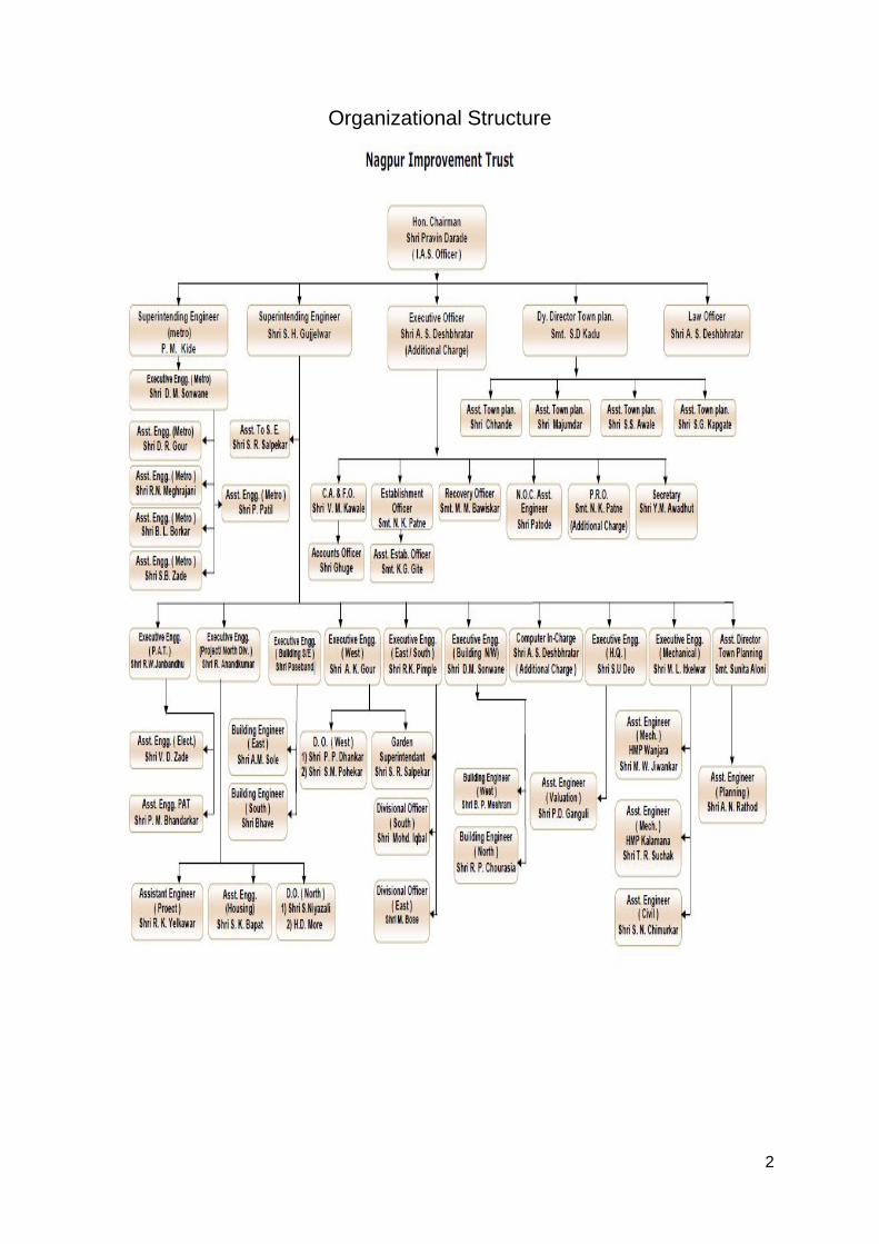
Organizational Structure
3
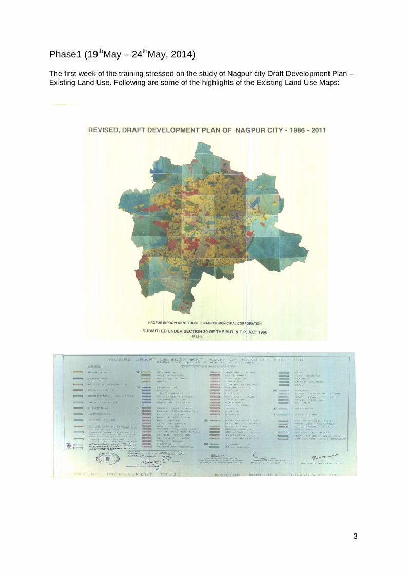
Phase1 (19thMay – 24thMay, 2014) The first week of the training stressed on the study of Nagpur city Draft Development Plan – Existing Land Use. Following are some of the highlights of the Existing Land Use Maps:
4
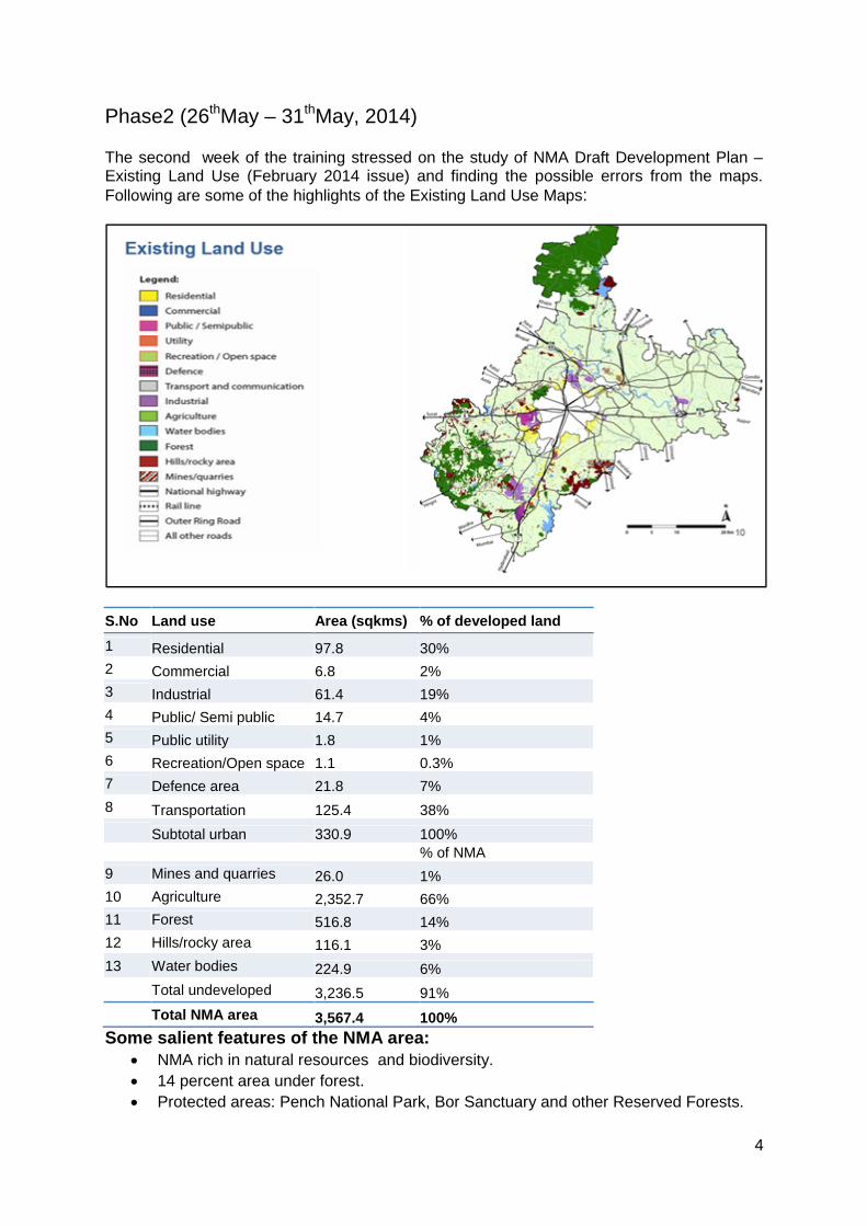
Phase2 (26thMay – 31thMay, 2014) The second week of the training stressed on the study of NMA Draft Development Plan – Existing Land Use (February 2014 issue) and finding the possible errors from the maps. Following are some of the highlights of the Existing Land Use Maps:
S.No Land use Area (sqkms) % of developed land 1 Residential 97.8 30% 2 Commercial 6.8 2% 3 Industrial 61.4 19% 4 Public/ Semi public 14.7 4% 5 Public utility 1.8 1% 6 Recreation/Open space 1.1 0.3% 7 Defence area 21.8 7% 8 Transportation 125.4 38% Subtotal urban 330.9 100% % of NMA 9 Mines and quarries 26.0 1% 10 Agriculture 2,352.7 66% 11 Forest 516.8 14% 12 Hills/rocky area 116.1 3% 13 Water bodies 224.9 6%
Total undeveloped 3,236.5 91% Total NMA area 3,567.4 100% Some salient features of the NMA area:
NMA rich in natural resources and biodiversity. 14 percent area under forest. Protected areas: Pench National Park, Bor Sanctuary and other Reserved Forests.
5
6 percent under water bodies (main rivers- Kanhan, Pench, Vena, Nag). Major reservoirs: Pench, Wadgaon, Vena and Bor. 8% of the NMA area under urban uses. Development concentrated close to the city and along major transport corridors. Total industrial area accounts for 1% of the NMA: MIDC Hingna and MIDC Butibori
major industrial areas. Haphazard conversion of land to Non Agriculture. Total area for which permissions granted 2001-2013 (March): 60sq km (2% of total
NMA area). 90% of the permissions sought for residential use. Contiguous pieces of land for NA observed in Nagpur Rural 3, Besa village. Industries locating closer to the city and along major transportation corridors. MIDC, Hingna has exhausted its capacity. MIDC, Butibori not attractive for smaller units. Kapsi (Kh) towards east of the city emerging as an industrial hub. Amravati road (NH6) emerging as a
logistics and trucking hub.
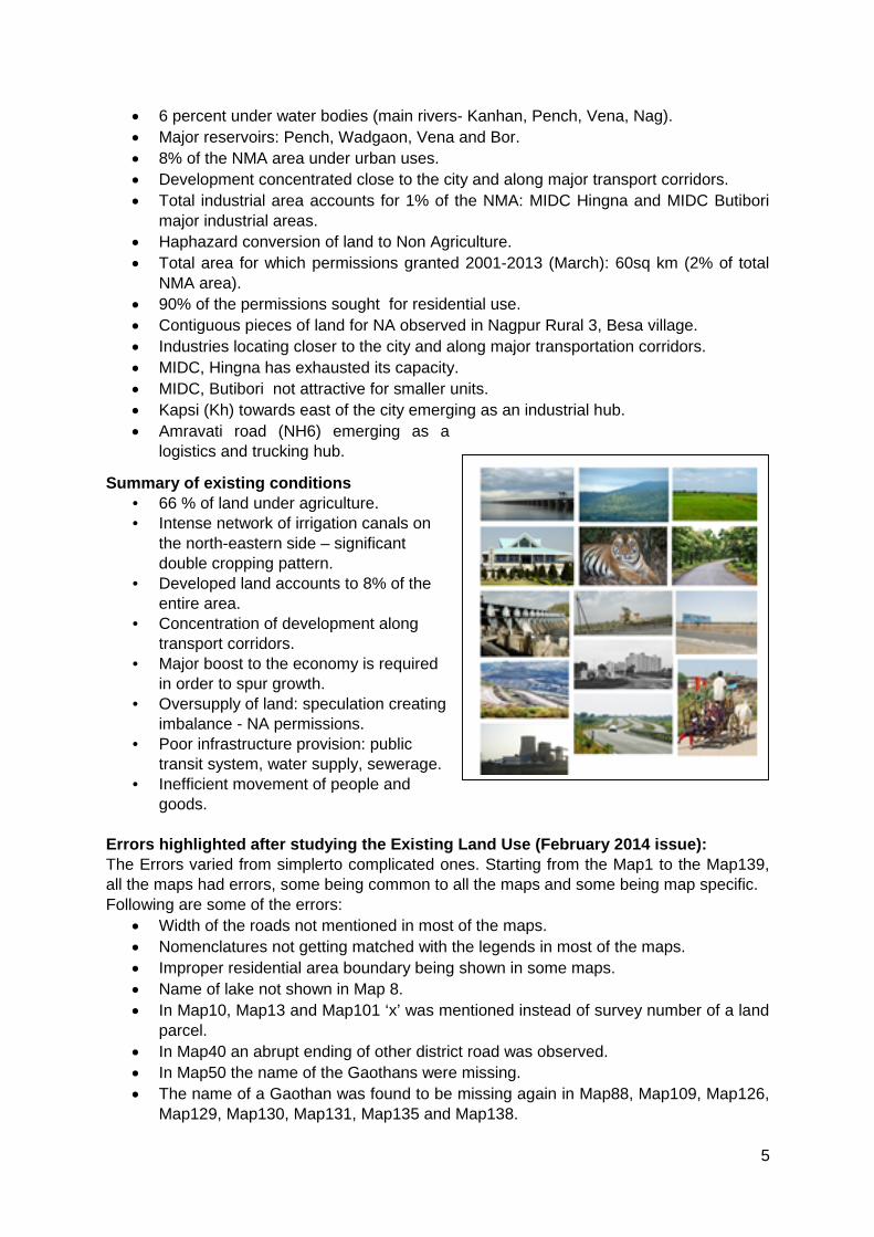
Summary of existing conditions • 66 % of land under agriculture. • Intense network of irrigation canals on
the north-eastern side – significant double cropping pattern.
• Developed land accounts to 8% of the entire area.
• Concentration of development along transport corridors.
• Major boost to the economy is required in order to spur growth.
• Oversupply of land: speculation creating imbalance - NA permissions.
• Poor infrastructure provision: public transit system, water supply, sewerage.
• Inefficient movement of people and goods.
Errors highlighted after studying the Existing Land Use (February 2014 issue): The Errors varied from simplerto complicated ones. Starting from the Map1 to the Map139, all the maps had errors, some being common to all the maps and some being map specific. Following are some of the errors:
Width of the roads not mentioned in most of the maps. Nomenclatures not getting matched with the legends in most of the maps. Improper residential area boundary being shown in some maps. Name of lake not shown in Map 8. In Map10, Map13 and Map101 ‘x’ was mentioned instead of survey number of a land
parcel. In Map40 an abrupt ending of other district road was observed. In Map50 the name of the Gaothans were missing. The name of a Gaothan was found to be missing again in Map88, Map109, Map126,
Map129, Map130, Map131, Map135 and Map138.
6
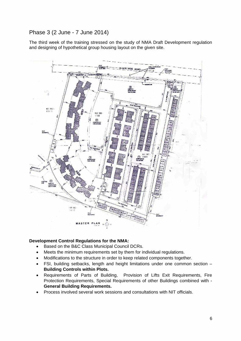
Phase 3 (2 June - 7 June 2014) The third week of the training stressed on the study of NMA Draft Development regulation and designing of hypothetical group housing layout on the given site.
Development Control Regulations for the NMA: Based on the B&C Class Municipal Council DCRs. Meets the minimum requirements set by them for individual regulations. Modifications to the structure in order to keep related components together. FSI, building setbacks, length and height limitations under one common section –
Building Controls within Plots. Requirements of Parts of Building, Provision of Lifts Exit Requirements, Fire
Protection Requirements, Special Requirements of other Buildings combined with - General Building Requirements.
Process involved several work sessions and consultations with NIT officials.
7
DCR for the NMA – New Sections Added: Requirements for fuel filling stations. Plantation and maintenance of trees. Boundary walls and gates. Easements. Sustainability. Additional fire protection requirements for public occupancy buildings (as per NBC,
2005). Development on narrow plots (Reference - Mumbai DCR). Regulation for resorts and amusement/ theme parks (Reference - MMR DCR). Regulations for quarries and mines (Reference - MMR DCR). Transit Oriented Developments. Low impact developments.
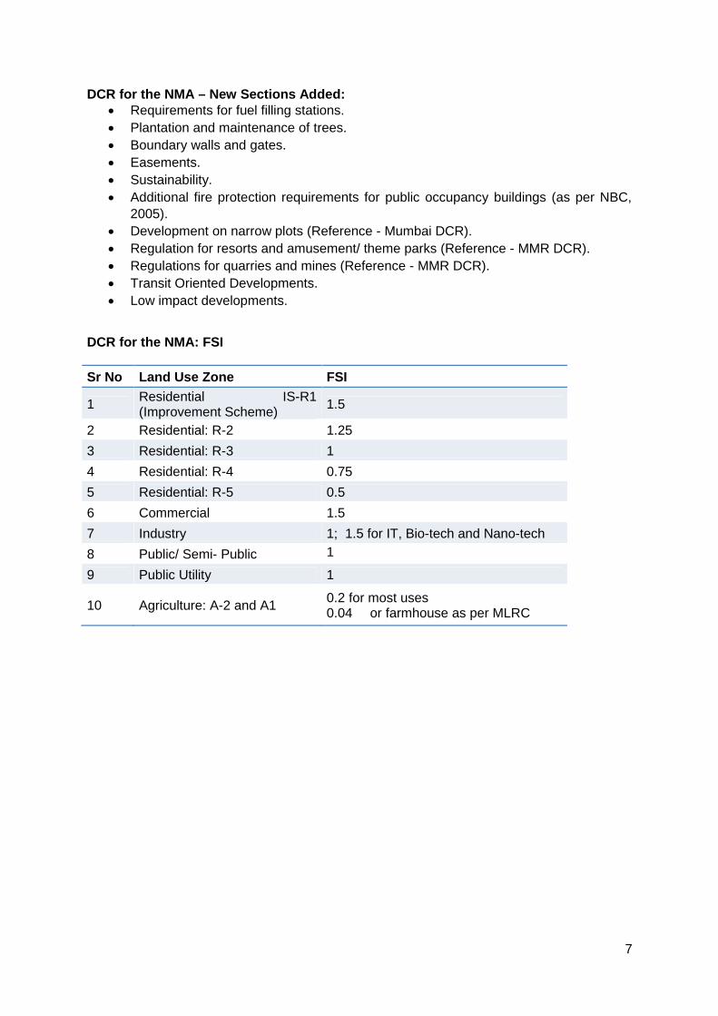
DCR for the NMA: FSI Sr No Land Use Zone FSI
1 Residential IS-R1 (Improvement Scheme) 1.5
2 Residential: R-2 1.25 3 Residential: R-3 1 4 Residential: R-4 0.75 5 Residential: R-5 0.5 6 Commercial 1.5 7 Industry 1; 1.5 for IT, Bio-tech and Nano-tech 8 Public/ Semi- Public 1
9 Public Utility 1
10 Agriculture: A-2 and A1 0.2 for most uses 0.04 or farmhouse as per MLRC
8
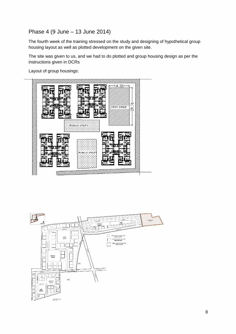
Phase 4 (9 June – 13 June 2014) The fourth week of the training stressed on the study and designing of hypothetical group housing layout as well as plotted development on the given site.
The site was given to us, and we had to do plotted and group housing design as per the instructions given in DCRs
Layout of group housings:
9
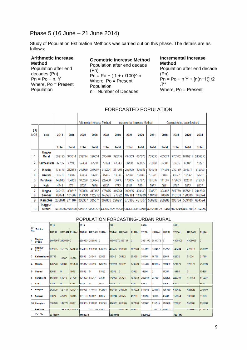
Phase 5 (16 June – 21 June 2014) Study of Population Estimation Methods was carried out on this phase. The details are as follows:
FORECASTED POPULATION
POPULATION FORCASTING-URBAN RURAL
Arithmetic Increase Method Population after end decades (Pn) Pn = Po + n. Ῡ Where, Po = Present Population n = Number of Decades
Geometric Increase Method Population after end decade (Pn) Pn = Po + ( 1 + r /100)^ n Where, Po = Present Population n = Number of Decades r = Average Geometric Rate
Incremental Increase Method Population after end decade (Pn) Pn = Po + n Ῡ + [n(n+1)] /2 .Ῡ* Where, Po = Present Population
10
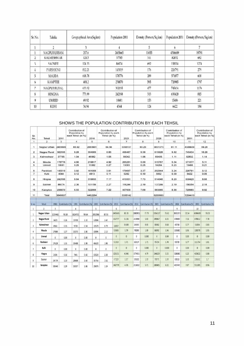
11
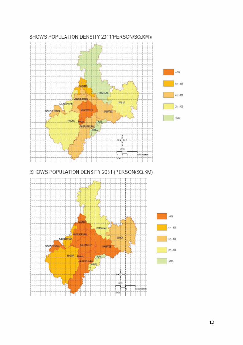
SHOWS THE POPULATION CONTRIBUTION BY EACH TEHSIL

12
This phase also included a brief insight into the following acts by Ms. Sujata Kadu (Dy. Director of Town Planning):
I. MRTP Act, 1966 II. LA Act, 1894 III. ULC Act, 1976 IV. Bombay Provincial Municipal Corporation Act, 1949 V. Maharashtra Municipal Council Act, 1965 VI. Bombay Stamp Act, 1958
VII. Constitutional Amendments Regarding Town Planning (73rd and 74th) VIII. Nagpur Improvement Trust Act.
IX. Process of Public Hearing.
13
Phase 6 (23th July, to 27th July, 2014) The last phase focussed on the Study of various sanctioned Layouts and related cases, Nagpur City Open Space Report, NMA Interim Concept Development Plan Report and Working on Area Calculation of Layout and Scrutiny of Layout Plan.
List of studied layout plan:
1. Yashvantrao Chavhan College of Engineering, Nagpur (Layout plan).
2. Private hospital Building plan.
List of Competitive exams discuss with Ms. Dy Director of T. Planning
1. MPSC (Maharashtra state Public service commission)
Post –Assistant T. Planner
2. UPSC (Union Public service commission)
Post –Assistant T. Planner
List of discuss DCRs and Development Plan formulation Guidelines:
NMC (Nagpur municipal council) DCRs
NMA (Nagpur Metropolitan Area) DCRs
Kerala Development Plan Formulation Handbook.