Embed Size (px)
Citation preview
1
Summary Report of SEIA and HCV Assessments on PT Bumi Sawit Permai
Rambang Kuang District of Ogan Ilir Regency and Lubai District of Muara Enim
Regency, South Sumatera Province
Executive Summary
PT Bumi Sawit Permai (hereinafter referred to as “PT BSP”) is located in Rambang
Kuang District of Ogan Ilir Regency and Lubai District of Muara Enim Regency, South
Sumatra and has obtained the Right of Cultivation (“HGU”) Certificate
No. 16/HGU/1990 covering an area of 7,579.90 hectares and the HGU Certificate No.
05 dated 13 November 2009 covering an area of 1,244 hectares.
PT BSP’s Environmental Impact Assessment (“EIA”) was carried out in association
with Environmental Studies Research Centre of Universitas Sriwijaya Research
Institute, having its address at Jl. Palembang-Prabumulih Km 32, Indralaya, Ogan Ilir,
South Sumatera. The EIA document was prepared in 2007. PT BSP has obtained
environmental assessment authorisation to its plantation development and oil palm
processing mill by virtue of South Sumatera Governor Decree No.
479/KPTS/BAPEDALDA/2007 dated 25 July 2007.
In addition to EIA, PT BSP already has Social Impact Assessment (“SIA”) document
and social impact management plan which was prepared by PT SMART, Tbk.’s internal
team (CSR Department). Necessary data were collected using indirect collecting system
method. This was carried out by means of desktop review on particular documents such as
EIA, HCV Assessment Report, and additional government data available on local
government’s website.
High Conservation Value (“HCV”) assessment was carried out in June 2010 over PT
BSP’s Bumi Sawit Estates (BSWE) Unit pursuant to the with area of 10,079.90 hectares
according to the location permit using HCV Area Assessment Toolkit Version 2008.
The HCV assessment was run by PT SMART, Tbk.’s Environmental Department staffs
consisting of specialists in habitat ecology and environmental service, as well as social,
economic and cultural aspects. The team members consisted of RSPO Approved HCV
Assessors. As part of the whole process, peer review on the HCV assessment was
2
performed by independent consultant in December 2010. The assessment findings
indicate that no primary forest found within PT BSP’s concession. The HCVs identified
are HCV 1.1, 1.2 and 4.1 with a total area of 325.58 hectares.
Scope of Social and Environmental Impact Assessment (SEIA) and HCV
Assessment
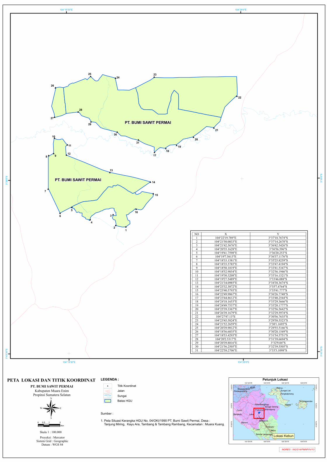
Company name : PT Bumi Sawit Permai
Location : Suka Merindu, Gunung Raja and Jiwa Baru Villages of Lubai
District, Muara Enim Regency, South Sumatera
Geographic site : (104°18’53.4293” - 104°26’39.1679” E) and (3°29’58.5523”
- 3°37’18.7674 S)
Bordering areas
a. North : Plantation Area with HGU Certificate No. 01 GS No.
03/OKI/1990
b. East : Unregistered land area
c. West : Unregistered land area
d. South : Unregistered land area
Permit/Concession :
1. HGU Certificate No. 16/HGU/1990 on Granting of HGU to PT BSP in
Rambang Kuang District, Ogan Ilir Regency, covering an area of
7,579.90 hectares, issued by National Land Agency Head.
2. HGU Certificate No. 5 for an area of 1,244 hectares issued by Regency/City
Land Office of Muara Enim, dated 13 November 2009.
Location Map : Figure 1
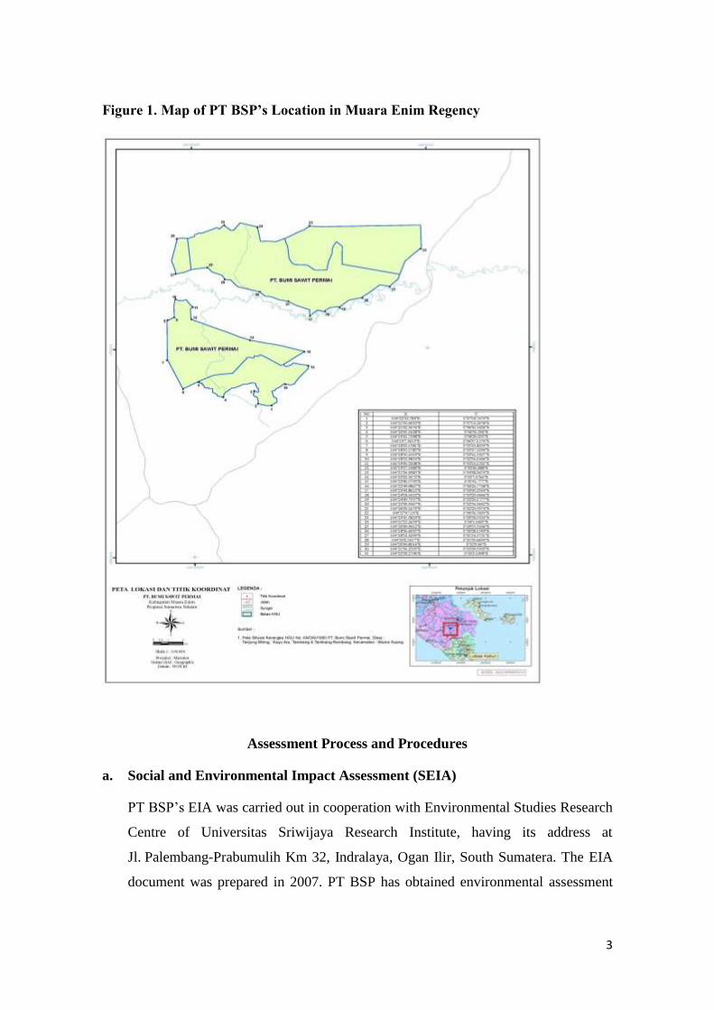
3
Figure 1. Map of PT BSP’s Location in Muara Enim Regency
Assessment Process and Procedures
a. Social and Environmental Impact Assessment (SEIA)
PT BSP’s EIA was carried out in cooperation with Environmental Studies Research
Centre of Universitas Sriwijaya Research Institute, having its address at
Jl. Palembang-Prabumulih Km 32, Indralaya, Ogan Ilir, South Sumatera. The EIA
document was prepared in 2007. PT BSP has obtained environmental assessment
4
authorisation to its plantation development and oil palm processing mill by virtue of
South Sumatera Governor Decree No. 479/KPTS/BAPEDALDA/2007 dated 25
July 2007.
In addition to EIA, PT BSP already has SIA document and social impact
management plan which was prepared by PT SMART, Tbk.’s internal team (CSR
Department). The data were collected using indirect collecting system method. This
was carried out by means of desktop review on particular documents such as EIA,
HCV Assessment Report, and additional government data available on local
government’s website. The assessment findings and social impact management plan
have been consulted with relevant stakeholders on 17 April 2013 at BMSE’s Meeting
Room in Rambang Kuang District of Ogan Ilir Regency and Lubai District of Muara
Enim Regency, South Sumatera. Public consultation was attended by, among others,
village heads and secretary, public figures, government office section heads, district
secretary, district military commander and local police staffs.
SIA Team Leader:
Yosaphat Ardhilla Renato, S.Ant.
Born in Yogyakarta on 5 February 1987, he is a Corporate Social Responsibility
(“CSR”) Officer to PT SMART, Tbk. Being an expert in social and cultural
anthropology, he graduated bachelor of anthropology from Anthropology
Department, Universitas Gadjah Mada (“UGM”) in 2010. He also joined HCV
Resources Network and registered as a Social Discipline Specialist (participatory
rural assessment; socio-economic or cultural studies; participatory mapping;
conflict resolution) to RSPO Approved HCV Assessors.
SIA Team Members:
Laurentius Vita Baskara, S.Sos.
Born in Yogyakarta on 29 April 1987, he is a staff to CSR Department with
expertise on social development and welfare. He graduated bachelor of social from
Social and Politics Faculty in 2010. His experience in surveying and assessing
5
social impact includes his works in a number of PT SMART, Tbk.’s plantations and
mills, such as social impact survey and analysis in North Sumatera, Jambi,
Belitung, etc. In addition, he has also been trained on Free, Prior and Informed
Consent (“FPIC”) and Social Mapping.
Veranita Mei Pratiwi, S.Ant.
Born in Magelang on 16 May 1987, she is a staff to CSR Department with expertise
on socio-cultural anthropology. Graduated bachelor of anthropology from Cultural
Anthropology of UGM in 2010, she has been involved in several SIA surveys in a
number of PT SMART, Tbk.’s plantation areas and mill.
Suma Nugraha, S.E.
Born in Garut on 7 July 1984, he is a staff to CSR Department with expertise on
socio-economy and politics. He graduated bachelor of economy from Economy and
Management Faculty of Bogor Agricultural University (“IPB”) in 2008, and once
worked for World Bank Survey Project as a supervisor. He also worked for Bravo
Media Center and held position of special staff to the 2009 elected Vice President.
He has experience as supervisor of media relation and monitoring when working
for PT FOX Indonesia Politic and Strategic Consulting. He has been involved in
activities of social data collection and social impact management in PT SMART,
Tbk.’s several plantation areas and mills.
Widodo C. Yuwono
He currently holds position of Social Impact Assessment & Grievance Section
Head. Having joined PT SMART, Tbk. since 1995, he graduated from Extra-
School Education Major of IKIP-Jakarta State University. His carrier started as a
Training Officer under Training & Development Department, tasked with training
planning, making training syllabus, delivering training, and evaluation and training.
Prior to holding position as Social Impact Assessment & Grievance Section Head,
he was tasked with pioneering the company’s CSR activities as a CSR Section
6
Head whose main job was planning and implementing the company’s CSR
activities.
Assessment Methods
a. SIA
Method employed to obtain social, economic and cultural data over the
neighbouring villages is data collecting by inventorying necessary information
through indirect collecting system which was performed through desktop
review analysing several reading materials such as EIA document, HCV
assessment, and governmental data supporting literature such as those at the
local government’s website. The secondary data collected, in addition to
through documents and literatures, are PT KDA’s CSR programmes
implementation documentation and local map. Against the literature data, these
data were analysed based on RSPO principles relevant to sustainable social
aspects.
b. HCV Assessment
The HCV assessment activities were carried out by Environment Department, of
PT SMART, Tbk. The team is as follow.
1. Norman Faried Mustakim
Born in Madiun on 26 February 1972, he currently is holding position as
Section Head of PT SMART, Tbk.’s Environment Department. His
expertise is HCV assessment on Habitat Ecology. Graduated bachelor
from Universitas Mulawarman, Samarinda in 1997, he has been trained
with Environmental Pollution Control (2008) held by Universitas Gadjah
Mada PSLH, EIA Preparation Course Type-B EIA (2006) by Universitas
Indonesia PSML, Jakarta, and Geo-Information, Atlas, And Mapping for
Business by Geospatial Information Agency (BIG). He is already
registered under RSPO Approved HCV Assessor.
7
2. Yosaphat A. Renato
Born in Yogyakarta on 5 February 1987, he is a staff of PT SMART,
Tbk.’s Environment Department. He graduated bachelor of anthropology
from UGM Faculty of Culture in 2010. His part in the HCV assessment is
community socio-cultural field. Having been experienced in SIA activities
in several companies, he was trained with FPIC and Social Need
Assessment (SNA) by LINKS, and Ecology and Cultural Training by State
Ministry of Environment.
3. Agus Budianto
Born in Klaten, 22 August 1980, he is a staff of PT SMART, Tbk.
Environment Department. He is experienced on HCV identification on Flora
Ecology. He obtained Diploma from UGM Faculty of Forestry in 1999 and
obtained his Bachelor of Forestry degree from Agriculture Faculty of
Universitas Kapuas Sintang in 2006. He was trained with HCV Forest
(HCVF) Management Training Program by WWF Pontianak in 2007. He was
involved in HCV assessment under cooperation with Fauna Flora
International (FFI), The Nature Conservancy (TNC) and PT Sari Bumi
Kusuma (Alas Kusuma Group), Central Kalimantan in 2008.
4. Nugroho Wahyu Widian
Born in Bogor on 12 April 1985, he is a staff of PT SMART Tbk.’s
Environment Department. His expertise is on Environmental Service HCV
Assessment. Graduated Bachelor of Forestry from UGM in 2008, he was
trained with Wildlife Species Inventorying by UGM in 2004. He has been
involved in HCV Forest (HCVF) assessment in PT SMART, Tbk.’s
concession, which was under cooperation with IPB LPPM, PT Mitrakarya
Agroindo and PT Buana Adhitama, Central Kalimantan in 2010. He was a
member of HCVF assessment team under cooperation of IPB Faculty of
Forestry and PT Bangun Nusa Mandiri, West Kalimantan in 2010.
5. Bambang Setyaji
8
Born in Blitar on 6 December 1982, he is a staff of PT SMART, Tbk.’s
Environment Department. His expertise is on Fauna Ecology HCV
Assessment. He obtained Diploma from UGM Faculty of Forestry in 2001
and graduated Bachelor of Forestry from Universitas Kapuas Sintang in
2006. He has been trained with HCV Forest (HCVF) Management
Training and Sustainable Forest Management held by The Nature
Conservancy (TNC) in 2008, and has been involved in HCV assessment
under cooperation with Fauna Flora International (FFI), TNC and PT Sari
Bumi Kusuma (Alas Kusuma Group).
Assessment Methods (Data sources, data collection, dates, programme and
visited places)
This HCV assessment and analysis was performed in PT BSP’s concession in
Rambang Kuang District of Ogan Ilir Regency and Lubai District of Muara
Enim Regency, South Sumatera. Villages neighbouring the concession are
Tange, Gunung Raja, Tamabangan, Sosokan and Jiwa Baru.
Data Collection Method
HCV 1, 2 and 3 Data Collecting process
Field data recorded are general condition of ecosystem and documentation of
vegetation and wildlife species which were emphasised at several observation
locations/spots in which HCV presence was indicated, using Rapid Assessment
method based on Landsat 7 ETM 543 Image Map, Semi-Detailed Soil Survey
Map and Final Mapping. The wildlife species were recorded based on both
direct observation (i.e. physical appearance of the wildlife individuals) and
indirect observation (based on the wildlife species’ signs of presence in their
habitat, such as footprint, faeces, sound, scratches on trees, arboreal species
corridor tracks through trees and interview with local community members and
estate workers/staffs. The observation detection was not directly based on each
of the wildlife species’ ecological and sociological life.
9
Vegetation and wildlife species recorded/documented were then determined by
referring to were recorded and then determined by referring to species naming
guidebooks in ‘binomial nomenclature’ manner to discover the species names.
Their conservation statuses were determined by referring to lists of protected
species based on IUCN and CITES rules as well as Indonesian Government
Regulation No. 7/1999 and other laws and regulations.
HCV 4 data collecting process
HCV 4 assessment ran by combining several methods. Field survey was
performed at areas estimated to have HCV potentials, as well as at particular
locations onsite such as basin, lake basin, spring areas, riparian ecosystems,
wetland ecosystems, and other types of land having high erosion hazard level,
areas in which fire had occurred, land clearing locations, nursery area, and
location of clean water resources supplying the community and staffs’ needs.
To obtain relevant data, interviews were done with several respondents from
the company staff and community member.
HCV 5 data collection process
Various methods have been employed to assess HCV 5 areas. Interview was
conducted by visiting a number of respondents from the neighbouring sub-
village/village community in search for relevant data.
Focus Group Discussion (FGD) was carried out to obtain more detailed
information, followed by groundchecking the areas estimated containing HCV
5 based on the FGD output. This groundcheck was carried out with help from
several community representatives and the Management Unit as the guide to
locations generated based on the FGD output. Social, economic and cultural
information was employed as secondary information, cited from the villages’
profiles, aside from the EIA report. And eventually, information interrelating
between the field fact and the secondary information were overlaid. The
10
location was identified by using Geographic Information System (GIS)
software application.
An area is deemed important if that area is utilised by one or more its
community members to meet their subsistent needs where no other alternatives
are available or cannot be replaced by substitution goods. Important category
threshold was set 50% or above of total number of one or more basic needs
which can be met by forest or other natural resources utilisation. Accessibility
is an important factor to take into account, aside from the substitution goods’
availability, availability period, and price affordability factors. In case of any
doubt, precautionary principles apply by assuming that the community has no
any alternative resources for need fulfilment. In certain cases, the assessment
team consults expert ecologists to determine this interaction.
HCV 6 data collection process
Information on areas having functions or values important to the community’s
traditional culture was obtained from the secondary data and preliminary data
analysis. Based on the preliminary information, HCV 6 potentials were
identified at landscape, ecosystem, and its components level important to
typical culture identification. Data source of this HCV 6 assessment are
subjects from the local community, i.e. the local community figures and the
community itself, as well as information from the research result, historical
documents and other documents available. In-depth information exploration for
this HCV 6 area identification also went through FGD.
Indicators used to indicate distribution of customary lands or forest resources
related to collective and individual behaviours in the local community in
meeting its cultural needs are, among other, zonation made based on certain
customary rules, archaeological sites distribution, the local community’s ritual
activities distribution, and distribution of bio-natural resources to meet cultural
needs.
This assessment was conducted by involving the Management Unit’s
management, along with offsite experts, and consulted with local community
leaders/customary leaders. In addition, the primary data collection aimed at
11
obtaining preliminary data on whether any areas recognised as customary area
was still present according to the indicators which had been set up. Aside from
an indicator presence, information was also explored on size or scale of the
indicators, e.g. with three scales (low-medium-high). What were also inquired
to the local community figures are how important meaning of the indicators to
the local community’s life.
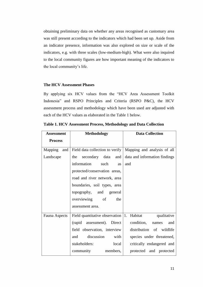
The HCV Assessment Phases
By applying six HCV values from the “HCV Area Assessment Toolkit
Indonesia” and RSPO Principles and Criteria (RSPO P&C), the HCV
assessment process and methodology which have been used are adjusted with
each of the HCV values as elaborated in the Table 1 below.
Table 1. HCV Assessment Process, Methodology and Data Collection
Assessment
Process
Methodology Data Collection
Mapping and
Landscape
Field data collection to verify
the secondary data and
information such as
protected/conservation areas,
road and river network, area
boundaries, soil types, area
topography, and general
overviewing of the
assessment area.
Mapping and analysis of all
data and information findings
and
Fauna Aspects Field quantitative observation
(rapid assessment). Direct
field observation, interview
and discussion with
stakeholders: local
community members,
1. Habitat qualitative
condition, names and
distribution of wildlife
species under threatened,
critically endangered and
protected and protected
12
Assessment
Process
Methodology Data Collection
company staffs, and other
relevant stakeholders.
categories of IUCN and
laws and regulations.
2. Qualitative condition of
wildlife species
population.
3. Wildlife species encounter
spots.
4. Wildlife species suffering
from poaching/hunting
activities.
5. Benefit from and
disruption to wildlife
species presence.
6. Level of wildlife species’
threaten and viability
level.
Flora Aspects Interview and direct field
survey, preliminary mapping
of ecosystem distribution,
observation of forest
structure, species density or
species domination over each
ecosystem type.
1. Data of flora with special
statuses.
2. Species protected by the
Government of Indonesia
or put under IUCN Red
List’s Endangered
classification.
3. Threats to and
opportunities of area
preservation.
Social, Interview and site visit, 1. Areas customarily
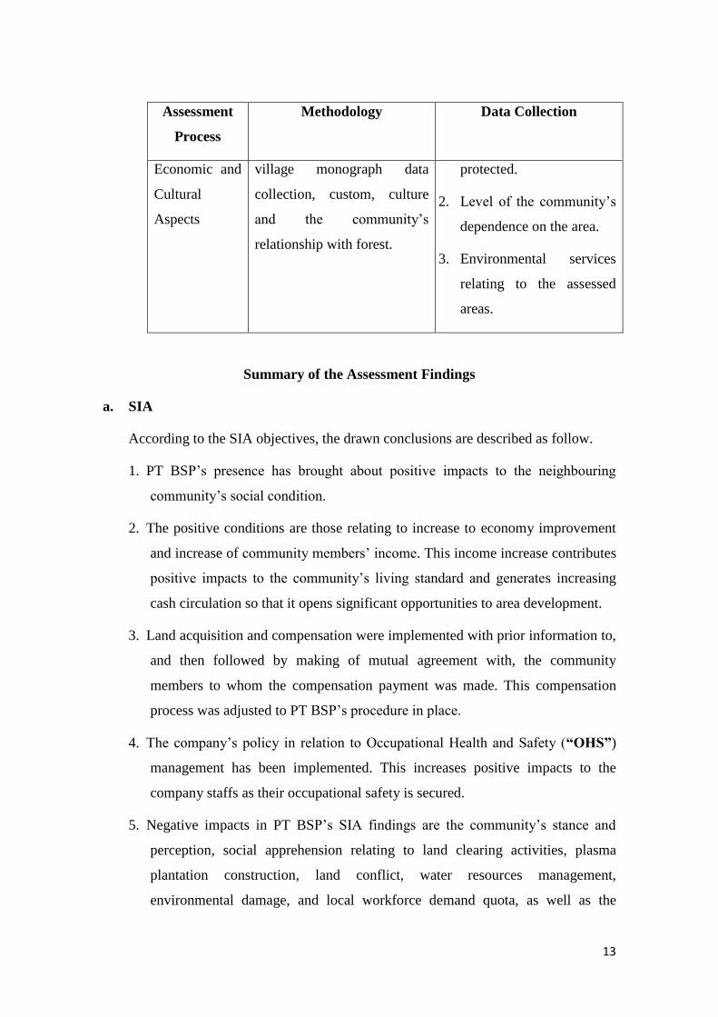
13
Assessment
Process
Methodology Data Collection
Economic and
Cultural
Aspects
village monograph data
collection, custom, culture
and the community’s
relationship with forest.
protected.
2. Level of the community’s
dependence on the area.
3. Environmental services
relating to the assessed
areas.
Summary of the Assessment Findings
a. SIA
According to the SIA objectives, the drawn conclusions are described as follow.
1. PT BSP’s presence has brought about positive impacts to the neighbouring
community’s social condition.
2. The positive conditions are those relating to increase to economy improvement
and increase of community members’ income. This income increase contributes
positive impacts to the community’s living standard and generates increasing
cash circulation so that it opens significant opportunities to area development.
3. Land acquisition and compensation were implemented with prior information to,
and then followed by making of mutual agreement with, the community
members to whom the compensation payment was made. This compensation
process was adjusted to PT BSP’s procedure in place.
4. The company’s policy in relation to Occupational Health and Safety (“OHS”)
management has been implemented. This increases positive impacts to the
company staffs as their occupational safety is secured.
5. Negative impacts in PT BSP’s SIA findings are the community’s stance and
perception, social apprehension relating to land clearing activities, plasma
plantation construction, land conflict, water resources management,
environmental damage, and local workforce demand quota, as well as the
14
community’s deteriorating health quality which frequently is related to water
declining quality, diseases caused by air pollution, mill activities, FFB
transporting activities, and poor sanitation quality.
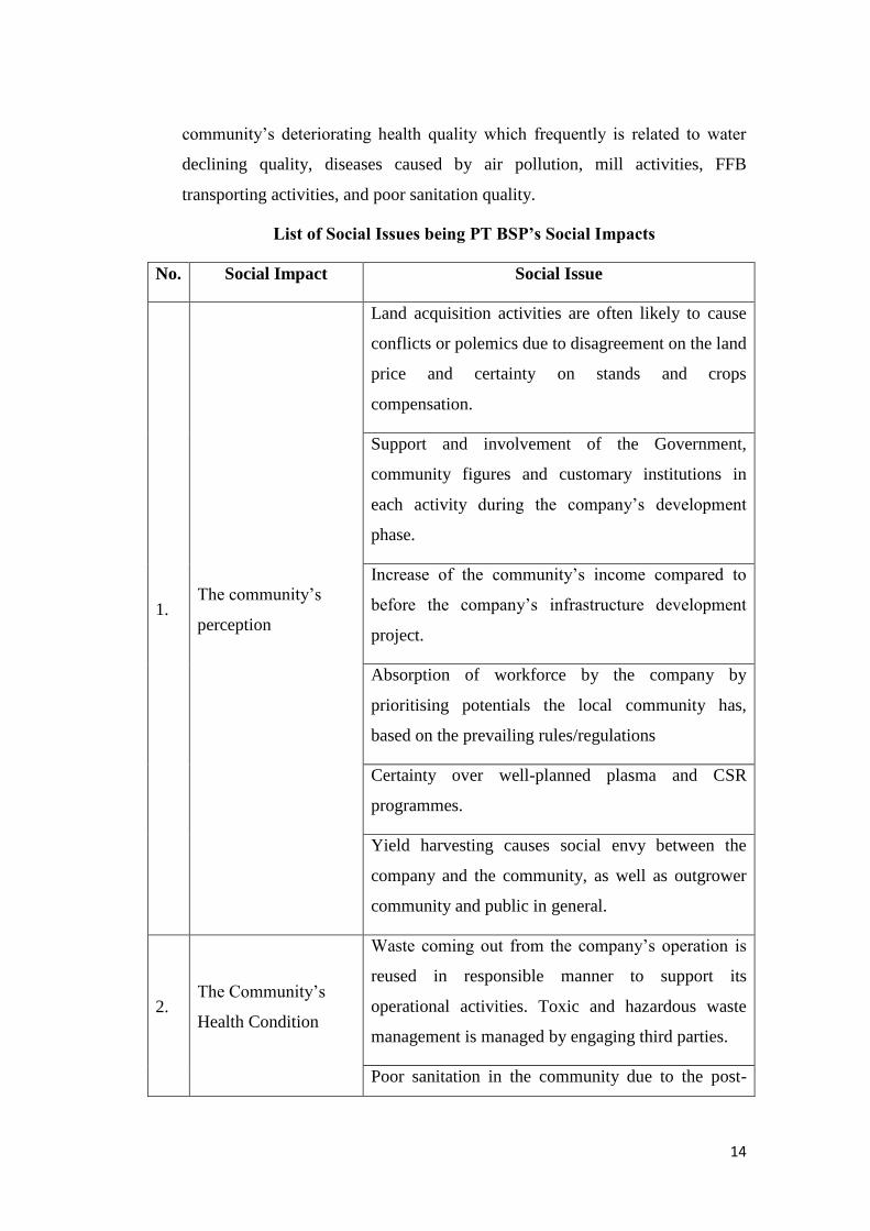
List of Social Issues being PT BSP’s Social Impacts
No. Social Impact Social Issue
1. The community’s
perception
Land acquisition activities are often likely to cause
conflicts or polemics due to disagreement on the land
price and certainty on stands and crops
compensation.
Support and involvement of the Government,
community figures and customary institutions in
each activity during the company’s development
phase.
Increase of the community’s income compared to
before the company’s infrastructure development
project.
Absorption of workforce by the company by
prioritising potentials the local community has,
based on the prevailing rules/regulations
Certainty over well-planned plasma and CSR
programmes.
Yield harvesting causes social envy between the
company and the community, as well as outgrower
community and public in general.
2. The Community’s
Health Condition
Waste coming out from the company’s operation is
reused in responsible manner to support its
operational activities. Toxic and hazardous waste
management is managed by engaging third parties.
Poor sanitation in the community due to the post-
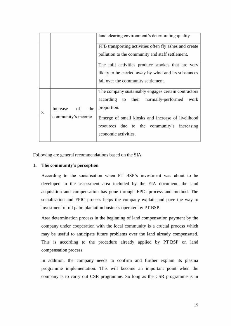
15
land clearing environment’s deteriorating quality
FFB transporting activities often fly ashes and create
pollution to the community and staff settlement.
The mill activities produce smokes that are very
likely to be carried away by wind and its substances
fall over the community settlement.
3. Increase of the
community’s income
The company sustainably engages certain contractors
according to their normally-performed work
proportion.
Emerge of small kiosks and increase of livelihood
resources due to the community’s increasing
economic activities.
Following are general recommendations based on the SIA.
1. The community’s perception
According to the socialisation when PT BSP’s investment was about to be
developed in the assessment area included by the EIA document, the land
acquisition and compensation has gone through FPIC process and method. The
socialisation and FPIC process helps the company explain and pave the way to
investment of oil palm plantation business operated by PT BSP.
Area determination process in the beginning of land compensation payment by the
company under cooperation with the local community is a crucial process which
may be useful to anticipate future problems over the land already compensated.
This is according to the procedure already applied by PT BSP on land
compensation process.
In addition, the company needs to confirm and further explain its plasma
programme implementation. This will become an important point when the
company is to carry out CSR programme. So long as the CSR programme is in
16
place, the plasma programme will be useful in reducing civil unrest and minimise
conflict potentials.
2. Community’s Health
According to the socialisation during investment phase, PT BSP would be built in
the assessment area as provided in EIA document. Water body’s declining quality
will impact on the community’s health, concerning that currently local community
in the neighbouring villages greatly depends on rivers, as fresh water source or as
place for daily bathing, washing, and toilet.
PT BSP needs to proactively communicate with its stakeholders in the assessment
area, socialisation and strict monitoring over its contractors in order to perform
environmental and health control. It needs to socialise and strictly monitor its
contractors to control the environment in their operational activities, apply best
practice on oil palm residue/waste and hazardous and toxic waste materials (B3),
and report social and environmental impact monitoring to relevant institution.
These are a series of the PT BSP’s endeavours in managing essential negative
impacts, namely social apprehension and the community’s health problem.
3. Increase of Community’s Income
The company has prepared a five-year CSR strategic plan consisting of
infrastructural development and empowerment programmes. The objective is to
improve education enterprise by embracing achieving students under scholarship
programme and supporting customary activities including several traditional
ceremonies held in the assessment area. The company’s compliance in paying taxes
indirectly helps or contributes to the local development. Plasma plantation
programme still serves as the primary in increasing the neighbouring community’s
income.
b. HCV Assessment
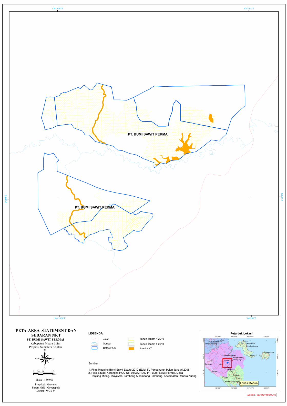
Based on the HCV assessment result, there are three HCV types identified in PT
BSP’s concession, i.e. HCV 1.1, HCV 1.2 and HCV 4.1. Total of the HCV area
within the concession is 325.58 hectares, which is elaborated as follow.
17
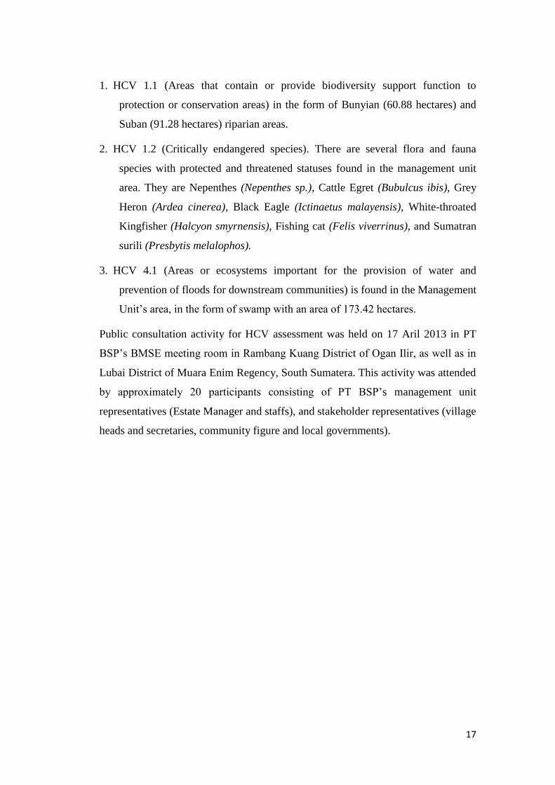
1. HCV 1.1 (Areas that contain or provide biodiversity support function to
protection or conservation areas) in the form of Bunyian (60.88 hectares) and
Suban (91.28 hectares) riparian areas.
2. HCV 1.2 (Critically endangered species). There are several flora and fauna
species with protected and threatened statuses found in the management unit
area. They are Nepenthes (Nepenthes sp.), Cattle Egret (Bubulcus ibis), Grey
Heron (Ardea cinerea), Black Eagle (Ictinaetus malayensis), White-throated
Kingfisher (Halcyon smyrnensis), Fishing cat (Felis viverrinus), and Sumatran
surili (Presbytis melalophos).
3. HCV 4.1 (Areas or ecosystems important for the provision of water and
prevention of floods for downstream communities) is found in the Management
Unit’s area, in the form of swamp with an area of 173.42 hectares.
Public consultation activity for HCV assessment was held on 17 Aril 2013 in PT
BSP’s BMSE meeting room in Rambang Kuang District of Ogan Ilir, as well as in
Lubai District of Muara Enim Regency, South Sumatera. This activity was attended
by approximately 20 participants consisting of PT BSP’s management unit
representatives (Estate Manager and staffs), and stakeholder representatives (village
heads and secretaries, community figure and local governments).
18
Figure 2. Identification/Assessment of PT BSP’s HCV Areas and Project Area
Petunjuk Lokasi
Liwa
Jambi
Metro
Plaju
LahatCurup
Mainna
Belinyu
Toboali
Panjang
Baturaja
Kotabumi
Bengkulu
Martapura
Palembang
KayuagungPrabumulih
Sungai LiatMuaratembesi
Tanjungpandan
Pangkalpinang
Sungai Gerong
Ranjaupanjang
Bandar Lampung
108°0'0"E
108°0'0"E
106°30'0"E
106°30'0"E
105°0'0"E
105°0'0"E
103°30'0"E
103°30'0"E
1°30'0
"S
1°30'0
"S
3°0'0"
S
3°0'0"
S
4°30'0
"S
4°30'0
"S
NOREG : 542/214/PMNP/IV/13
PETA LOKASI DAN TITIK KOORDINAT
Lokasi Kebun
LEGENDA :
!
!
!
!
!
##
#
#
#
#
#
##
#
#
#
#
#
#
#
12
3
4
56
7
8 9
10
11
12
13
14
15
16
#
17
#
#
#
#
#
##
#
#
#
#
#
#
#
1819
20
21
22
2324
25
26
27
28
29
30
31
104°28'0"E
104°28'0"E
104°19'30"E
104°19'30"E3°3
5'0"S
3°35'0
"S
3°43'3
0"S
3°43'3
0"S
PT. BUMI SAWIT PERMAI
PT. BUMI SAWIT PERMAIKabupaten Muara Enim
Propinsi Sumatera Selatan
®Proyeksi : Mercator
Sistem Grid : GeographicDatum : WGS 84
Skala 1 : 100.000
0 1 20.5Km
Sumber :1. Peta Situasi Kerangka HGU No. 04/OKI/1990 PT. Bumi Sawit Permai, Desa : Tanjung Miring, Kayu Ara, Tambang & Tambang Rambang, Kecamatan : Muara Kuang.
NO X Y 1 104°22'19.789"E 3°37'18.7674"S 2 104°21'50.0033"E 3°37'14.2678"S 3 104°21'42.5676"E 3°36'42.5426"S 4 104°20'35.1628"E 3°36'56.596"S 5 104°19'41.7598"E 3°36'20.253"S 6 104°19'7.5613"E 3°36'37.1176"S 7 104°18'33.1581"E 3°35'25.8259"S 8 104°18'35.5785"E 3°33'47.4194"S 9 104°18'50.1019"E 3°33'41.5347"S
10 104°18'52.9854"E 3°32'56.1946"S 11 104°19'30.3208"E 3°33'16.1521"S 12 104°19'27.5489"E 3°33'46.088"S 13 104°21'34.0985"E 3°34'38.3674"S 14 104°23'32.3072"E 3°35'7.4764"S 15 104°23'40.5793"E 3°35'41.777"S 16 104°22'49.9867"E 3°36'26.7748"S 17 104°23'44.8612"E 3°33'40.2544"S 18 104°24'18.1653"E 3°33'29.3666"S 19 104°24'49.7537"E 3°33'20.1777"S 20 104°25'39.3367"E 3°32'56.5642"S 21 104°26'39.1679"E 3°32'29.5974"S 22 104°27'47.13"E 3°30'56.7635"S 23 104°23'45.5824"E 3°29'58.5523"S 24 104°21'52.2659"E 3°30'1.1695"S 25 104°20'39.9012"E 3°29'55.5166"S 26 104°18'56.6035"E 3°30'28.1549"S 27 104°18'53.4293"E 3°31'54.5751"S 28 104°20'2.5317"E 3°31'39.6694"S 29 104°20'39.8016"E 3°32'9.04"S 30 104°21'56.2505"E 3°32'39.5505"S 31 104°22'58.2706"E 3°33'3.1098"S
Batas HGU
JalanSungai
# Titik Koordinat
PT. BUMI SAWIT PERMAI
Petunjuk Lokasi
Liwa
Jambi
Metro
Plaju
LahatCurup
Mainna
Belinyu
Toboali
Panjang
Baturaja
Kotabumi
Bengkulu
Martapura
Palembang
KayuagungPrabumulih
Sungai LiatMuaratembesi
Tanjungpandan
Pangkalpinang
Sungai Gerong
Ranjaupanjang
Bandar Lampung
108°0'0"E
108°0'0"E
106°30'0"E
106°30'0"E
105°0'0"E
105°0'0"E
103°30'0"E
103°30'0"E
1°30'0
"S
1°30'0
"S
3°0'0"
S
3°0'0"
S
4°30'0
"S
4°30'0
"S
NOREG : 544/214/PMNP/IV/13
PETA AREA STATEMENT DANSEBARAN NKT
Lokasi Kebun
LEGENDA :
!
!
!
!
!
104°28'0"E
104°28'0"E
104°19'30"E
104°19'30"E3°3
5'0"S
3°35'0
"S
PT. BUMI SAWIT PERMAI
PT. BUMI SAWIT PERMAIKabupaten Muara Enim
Propinsi Sumatera Selatan
®Proyeksi : Mercator
Sistem Grid : GeographicDatum : WGS 84
Skala 1 : 80.000
0 0.8 1.60.4Km
Sumber :1. Final Mapping Bumi Sawit Estate 2010 (Edisi 3), Pengukuran bulan Januari 2006.2. Peta Situasi Kerangka HGU No. 04/OKI/1990 PT. Bumi Sawit Permai, Desa : Tanjung Miring, Kayu Ara, Tambang & Tambang Rambang, Kecamatan : Muara Kuang.
Batas HGU
JalanSungai
Tahun Tanam < 2010Tahun Tanam > 2010Areal NKT
PT. BUMI SAWIT PERMAI