Embed Size (px)
Citation preview
BO'rlLE
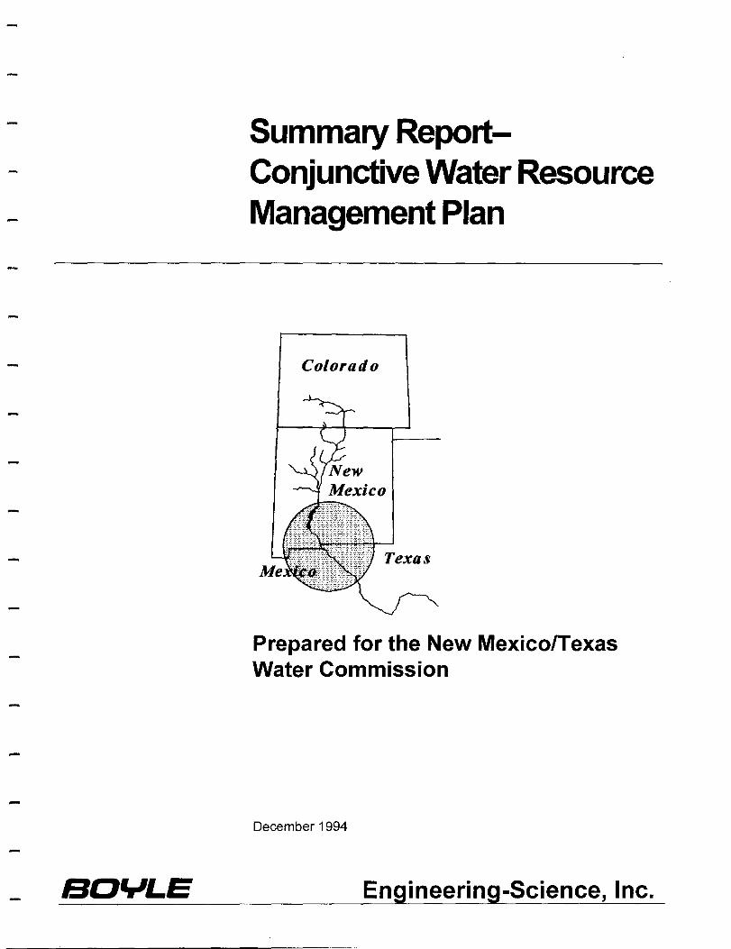
Summary ReportConjunctive Water Resource Management Plan
Colorado
Texas
Prepared for the New MexicolTexas Water Commission
December 1994
Engineering-Science, Inc.
Overview
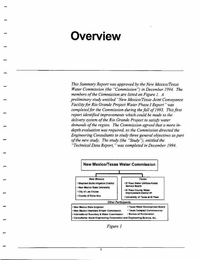
This Summary Report was approved by the New Mexico/Texas Water Commission (the "Commission '') in December 1994. The members of the Commission are listed on Figure 1. A preliminary study entitled "New Mexico/Texas Joint Conveyance Facility for Rio Grande Project Water Phase I Report" was completedfor the Commission during the fall of 1993. This first report identified improvements which could be made to the delivery system of the Rio Grande Project to satisfy water demands of the region. The Commission agreed that a more indepth evaluation was required, so the Commission directed the Engineering Consultants to study three general objectives as part of the new study. The study (the "Study''), entitled the "Technical Data Report," was completed in December 1994.
New MexicofTexas Water Commission
I I _1
New Mexico Texas
• Elephant Butte Il11gatlon District • EI Paso Water utilities-Public
• Naw Mexico State University Service Board
• City of Las Cruces • EI Paso County Water
Improvement District 111 • County of Dona Ana • University of Texas at EI Paso
Other Participants
• New Mexico State Engineer • Texas Water Development Board
• New Mexico Interstate Stream Commission • Texas Compact Commissioner
• International Boundary & Water Commission • Bureau of Reclamation
• ConsuHants: Boyle Engineering Corporation and Engineering-Science, Inc.
Figure 1
The Technical Data Report was financed by members of the Commission, as well as the New Mexico Interstate Stream Commission and the Texas Water Development Board. The purpose of the Technical Data Report was to examine surface water conveyance and treatment alternatives from Caballo Dam to the City of El Paso to increase the municipal and industrial use of surface water, improve the quality of surface water for all users, and extend the ground water resources of the region. This 100-river-mile study area is shown on Figure 2.
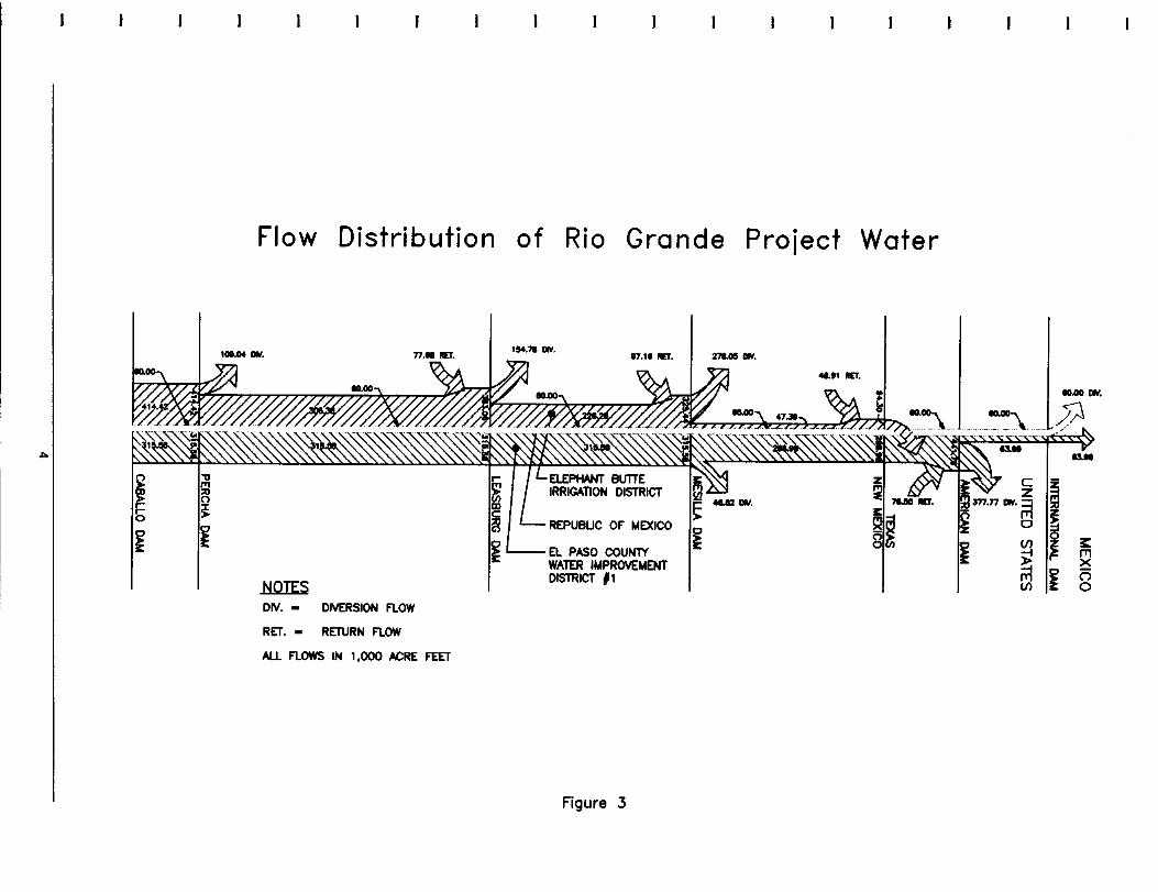
The Rio Grande Project is a Bureau of Reclamation Project. Under a treaty with Mexico, the Rio Grande Compact, and Reclamation law, 60,000 AF of water is delivered to Mexico while 56.77 percent of the remaining supply is allocated to Elephant Butte Irrigation District (the "New Mexico Project Water ") and 43.23 percent is allocated to the El Paso Water Improvement District No.1 (the "Texas Project Water"). Figure 3 is a conceptual diagram of the historic operation of the Rio Grande Project during a normal year. It reflects how New Mexico and Texas Project Water is diverted at different points from the river, the location of the diversion to Mexico of its 60,000 AF, as well as the amounts and locations of return flows coming back into the system.
The Commission was formed as part of the settlement of 1 0 years of costly litigation resulting from the City of El Paso's attempt to obtain New Mexico ground water to meet its municipal needs. In the March 1991 Settlement Agreement, the parties agreed that the members of the Commission would work together to address the water issues facing the region from below Elephant Butte dam in southern New Mexico to El Paso. El Paso agreed to withdraw its legal attempts to obtain New Mexico ground water and agreed to use more Texas Project Water to address its municipal needs. The New Mexico parties agreed to facilitate greater use of Texas Project Water by working toward its yearround delivery and, ifwarranted, support the construction of new conveyance facilities for transporting Texas Project Water.
2

co CD L..
< ~ "0 :::l +-t CI)
CD
~ I L-CD > .-a: I
o o or-
3
I I
..,.
~
."
~ ~
~
Flow Distribution of Rio Grande Project Water
NOTES DIV. - DIVERSION FLOW
RET. - RETURN FlOW
AlL FLOWS IN 1,000 ACRE FEET
'54.'" 001.
REPUBUC OF MEXICO
El PASO COUNlY WATER IMPROVEMENT DISTRICT #1
Figure 3
271.05 001.
~ ~ _001.
~
10.00 001 •
I VI 5 i:
~ ~ ~ '-I ~ -", (") VI 0
This Summary Report recommends proceeding with an initial construction phase ("Phase 1 ") which encompasses approximately 38 miles of canal within the 1 OO-river-mile Study area. The Commission believes Phase 1 will accomplish the majority of the goals of the Study within the shortest amount of time, and with the least change to the current operation of the Rio Grande Project. Phase 1 is the improvement and enlargement of the existing Rio Grande Project distribution system from Mesilla Dam in New Mexico to the American Dam in EI Paso. The specific alignment and sequencing of Phase 1 will be developed after completing a detailed planning/design stage; however, the contemplated improvements for Phase 1 are described on page 20 in the section of this Summary Report entitled "Description of Phase 1." Initially, it was anticipated that the primary benefit to the New Mexico members of the Commission would be the protection of New Mexico ground water. However, the Commission now believes that with the inclusion in the Phase 1 components of the lining of Elephant Butte Irrigation District canals, new control structures, improved management information systems, and a new surface water treatment plant near the New Mexico border, there will be many more benefits to New Mexico than originally anticipated. Several of these improvements will also benefit the delivery of the Texas Project Water to the Texas farmers, and will make it possible to improve the quality of water to the Texas farmers. Finally, the year-round delivery of water will give the Texas and the New Mexico farmers the ability to grow year-round crops.
5
Purpose of Technical Data Report
The purpose of the Technical Data Report was to evaluate at a reconnaissance level the effects of constructing surface water conveyance facilities to supply the needs of the population in the Study area to the year 2035.
The purpose of the Technical Data Report was to present findings from a reconnaissance level study of constructing surface water conveyance facilities to:
• supply the needs of the population in the Study area to the year 2035;
• improve the efficiency of surface water use;
• achieve year-round delivery of surface water;
• improve the quality of surface water; and
• protect the Hueco and Mesilla Basins from overdrafting.
Three important factors have created the need to conduct a study to evaluate water conveyance concepts in the region:
1. Projected population increases-The population of the Study area, including Dona Ana County, New Mexico; El Paso County, Texas; and Ciudad Juarez, Mexico, is experiencing significant growth. It is projected to grow vigorously in the future because of the increasing business activity in Mexico, accelerated by NAFT A.
2. Projected aquifer depletion-The area's present municipal and industrial (M&I) water supply is predominantly from the Hueco Basin and Mesilla Basin aquifers. The Hueco Basin is presently overdrafted, and projected future increased water demands will only accelerate the rate of ground water depletion.
3. Projected short-falls in water supply-A comparison of future water demand projections with future water availability from current sources shows that critical shortfalls in supply will occur in about 30 years.
The formation and work of the Commission has advanced the understanding of the region's water supply situation. The Commission has sponsored this and previous studies to identify methods and means by which the overall water supply will be made sufficient and sustainable in the future.
6
Alternative Water Service Concepts
The water service concepts were evaluated with respect to reliability of supply, capital and O&M costs, impacts to the flow in the Rio Grande, and impacts to the aquifers in the region.
The Commission requested the investigation of a range of service concepts which would provide a year-round supply of surface water and improve water quality. Initially the improved supply would accommodate the existing Canal Street and Jonathan Rogers Water Treatment Plants in the City ofEI Paso and a new water treatment plant near Canutillo, Texas, to serve the upper valley in Texas and portions of southern New Mexico near the state line. In the future the water would supply additional surface water treatment plant capacity to serve consumers in New Mexico, Texas, and possibly Mexico. Water service concepts evaluated include new pipe, canal, and treatment facilities, as well as using the existing conveyance system. The water service concepts were evaluated with respect to reliability of supply, capital and O&M costs, impacts to the quantity and quality of flow in the Rio Grande, and impacts to the aquifers in the region. The information developed through these evaluations provides the basis for discussion among the Commission, allowing the formulation of the next step in the process.
The Study work tasks of the Engineering Consultants were designed to provide information to assist the Commission in evaluating the following factors:
• the general physical layout and features of the service concepts,
• projected ranges of costs for the. water service concepts, and
• systemic effects on the total water resource of the entire region.
At this phase of project development, the Commission limited the Study to the use of existing data available from standard sources to reduce costs. Additional data will be required to advance planning into a preliminary engineering phase. The water service concepts evaluated are to broadly represent approaches to the water supply needs of the region; they are not to be construed as defined plans or preconceived notions of the ultimate solution.
7
Alternative Water Service Concepts
Analysis of Water Service Concepts
To achieve the objectives of the Study, water service concepts were analyzed to assess physical feasibility, estimate costs, and assess impacts to the hydrologic system. The following analyses were performed:
• General physical features were conceptualized that would fulfill the service requirements. The service requirements consisted of water supply demands determined for the future at three planning horizons representing the years 2005,2015, and 2035.
• Conceptual hydraulic designs were performed for each planning horizon.
• Conceptual designs of facilities for surface water treatment, storage, and distribution were also prepared for each planning horizon.
• An opinion of estimated probable construction cost was developed.
• Computer models using spreadsheet methods to represent greatly simplified versions ofthe surface water and alluvial aquifer hydrology were developed. These models were used to assess systemic impacts to the Rio Grande system.
8
Assumptions
Hydrology
Topographical
Water Quality
Population
The data analyses perfonned in this Study required certain assumptions. Some of these assumptions were made with regard to historical events and some for future events. Based on the Commission's directive that only existing data be used, no exhaustive research or verification of these assumptions was conducted.
The future inflows to Elephant Butte and Caballo Reservoirs are assumed to be identical to past inflows; however, future releases have been altered from past releases to optimize the amount of surface water used for each water service concept.
U.S.G.S. mapping is assumed to represent the currently existing land surfaces.
The Total Dissolved Solids (TDS) concentration in Caballo Reservoir is assumed to remain at historicalleve1s. Further, the TDS concentration from agricultural return flows is assumed to follow historical patterns.
Area
El Paso County, Texas
Dona Ana County, New Mexico
Ciudad Juarez, Chihuahua, Mexico
9
Population Assumptions
Growth rate at 2.1 % per year compounded
City of Las Cruces-growth rate at 2.5% per year compounded
Extraterritorial of Las Cruces-growth rate at 2.8% per year compounded
Total Population 1990--798,499 Total Population 1994-1,134,000 Future Population-straight line
projection of 199011994.
~umptions
Municipal & Industrial Water Demand
Capital Costs Basis
For all U.S. areas of the Study region, the future per capita M&I demand is assumed at 160 gallons per capita per day, annual average, as a targeted goal (the current per capita per day demand is 177 gallons for the City ofEI Paso and over 200 gallons for the City of Las Cruces). For Ciudad Juarez, Mexico, the per capita water demand is assumed to be 90 gallons per capita per day, annual average.
The cost of capital for borrowing or bonding is assumed to be 6 percent. The inflation rate is assumed to be 3 percent per annum, compounded.
Water Budget Spreadsheet Model Assumptions
Simplifying assumptions were necessary to represent a very complex system, but these assumptions were applied consistently to allow a fair comparison of different water supply concepts.
To represent the Rio Grande system in a spreadsheet model, numerous assumptions were necessary to describe the hydrologic characteristics and operations within the Study area for the baseline-representing the no-action case-and various sustainable water supply concepts.
The major hydrologic assumptions were:
• A water quantity and quality budget adequately represents the physical system to allow relative comparisons of the systemic effects to the system from each water supply concept.
• The hydrologic variability of the system during the past 40 years can be represented by using typical wet, dry, and average conditions.
• The same demands for water were used consistently so that results could be compared among water supply concepts.
The major operational assumptions were:
• The water supply system would be operated to provide the maximum amount of water to each user.
10
Assumptions
• Within a one-year period, Caballo Dam would be operated so that monthly releases could vary from historical levels, as long as the total annual release is the same as it was historically.
• When surface water deliveries are reduced, ground water pumping is assumed to provide the water necessary to meet the unfilled demand.
• Canal releases would be adjusted so that some flow would remain in the river.
11
Findings
The following discussions and tabulations are condensed results of key evaluations performed in the Study. Results pertaining to water supply availability, impacts to the river, and impacts to the aquifers associated with each water service concept are presented. In addition, this section discusses the functions of the irrigation drain system and why it should be protected by the Project.
Water Quantity and Quality
For each supply concept, the quantity and quality of water available to each user was either improved or unchanged.
Under existing conditions, the Rio Grande is the main conveyance channel for delivery of Project water. Water is removed from the river at diversion dams and supplied to the various users. Return flows from municipalities and agricultural lands drain back to the river at various locations. As the Rio Grande progresses downstream, the mixing of river water and return flows results in lower water quality because of higher concentrations of salts in the water.
Operation of the Rio Grande system under each of the water supply concepts removes water from the river and conveys it in canals or pipelines to its ultimate destination. With less water in the river, there is less volume available to dilute the salt load carried by the agricultural return flows, and the quality of the water in the river is lowered at all locations below Percha Dam.
The water budget analyses performed provided quantitative estimates of the impacts to river flows and the quality of these flows at key locations under varying hydrologic conditions. These results are summarized in the Technical Data Report. While preliminary and very approximate, the fundamental finding with regard to systemic effects to the hydrologic system is that no insurmountable problem was identified which would preclude any of the water supply concepts.
In addition to assessing probable impacts to the hydrologic system, the water budget analysis also provides a measure of the quantity and quality of water available to all of the water users. The quantity and quality of water available to each user was either improved or unchanged. To achieve this result, continued use of ground water and/or the reuse ofretum flows will be required.
12
Findings
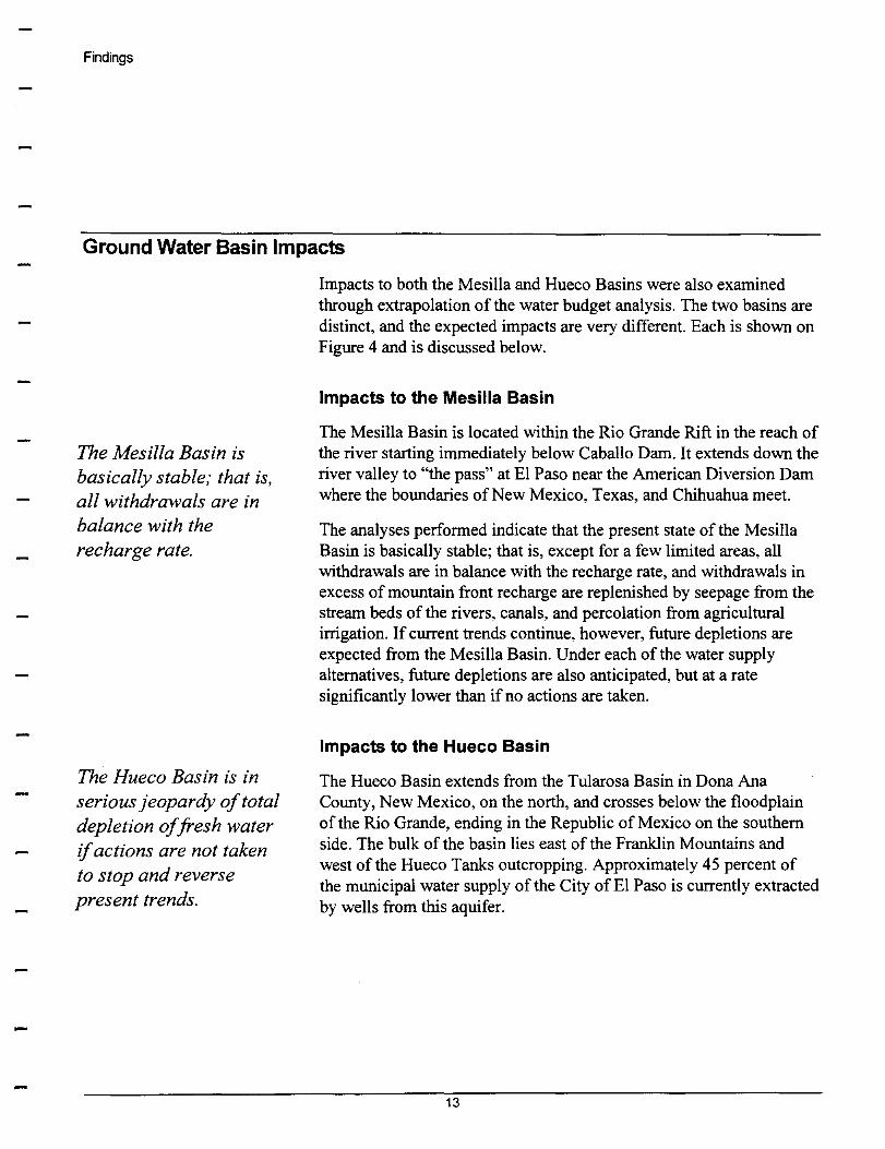
Ground Water Basin Impacts
The Mesilla Basin is basically stable; that is, all withdrawals are in balance with the recharge rate.
The Hueco Basin is in serious jeopardy of total depletion of fresh water if actions are not taken to stop and reverse present trends.
Impacts to both the Mesilla and Hueco Basins were also examined through extrapolation of the water budget analysis. The two basins are distinct, and the expected impacts are very different. Each is shown on Figure 4 and is discussed below.
Impacts to the Mesilla Basin
The Mesilla Basin is located within the Rio Grande Rift in the reach of the river starting immediately below Caballo Dam. It extends down the river valley to "the pass" at El Paso near the American Diversion Dam where the boundaries of New Mexico, Texas, and Chihuahua meet.
The analyses performed indicate that the present state of the Mesilla Basin is basically stable; that is, except for a few limited areas, all withdrawals are in balance with the recharge rate, and withdrawals in excess of mountain front recharge are replenished by seepage from the stream beds of the rivers, canals, and percolation from agricultural irrigation. If current trends continue, however, future depletions are expected from the Mesilla Basin. Under each of the water supply alternatives, future depletions are also anticipated, but at a rate significantly lower than if no actions are taken.
Impacts to the Hueco Basin
The Hueco Basin extends from the Tularosa Basin in Dona Ana County, New Mexico, on the north, and crosses below the floodplain of the Rio Grande, ending in the Republic of Mexico on the southern side. The bulk of the basin lies east of the Franklin Mountains and west of the Hueco Tanks outcropping. Approximately 45 percent of the municipal water supply of the City of El Paso is currently extracted by wells from this aquifer.
13
Findings
Mesilla and Hueco Basins
Mesilla Basin --
United States
Mexico
Cd. Juarez
Figure 4
14
Las Cruces
Hueco Basin
New Mexico
Texas
EIPaso
Findings
u. c:( o g ...
6000
5000
4000
3000
2000
1000
o
1990
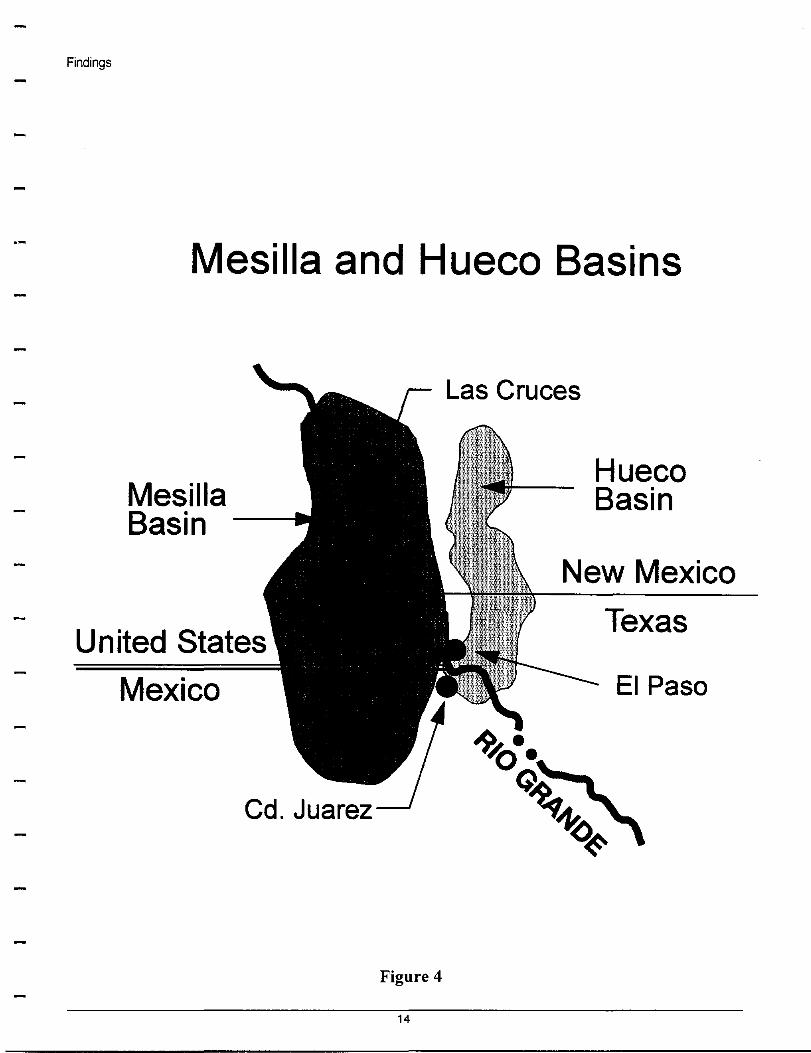
This Study indicates that stability of the Hueco Basin cannot be achieved--even under the most aggressive scenario of replacing ground water with surface water for the City of El Paso-without artificial recharge. As illustrated on Figure 5, this aquifer is in serious jeopardy of total fresh water depletion if actions are not taken to stop and reverse present trends. The extraction of ground water from the Hueco Basin by Ciudad Juarez is not within the jurisdiction of the United States entities.
Without Change, Hueco Will Soon Be Depleted
2000 2010 2020 2030 Year
Figure 5
15
2040
Findings
This strongly indicates that cooperative conjunctive water supply planning efforts with the Republic of Mexico should be pursued, and implementation of an aquifer storage and recovery program undertaken.
Characteristics of Irrigation System: Drain and Return Flows
The water budget model used the seasonal and historical application of irrigation water on the agricultural lands, and evaluated how the system might be impacted by the proposed construction of a conveyance channel. The preliminary analyses indicated that, in general, the irrigation and drainage system would continue to function as intended under all of the water supply concepts. Analyses conducted at a significantly greater level of detail would be required to assess drain performance on a more site-specific basis.
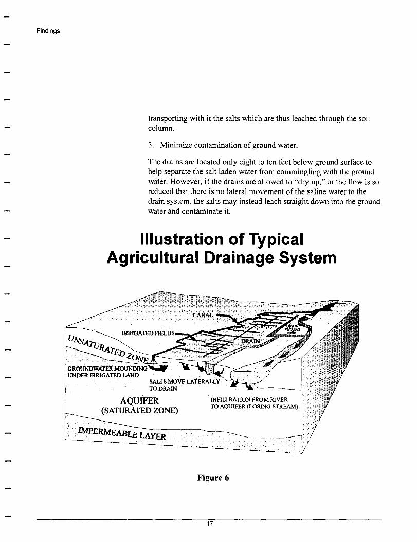
The Commission recognizes the following three functions which are performed by the drain system, illustrated by Figure 6, which it believes are critical to maintaining the viability of the agricultural uses, and should be protected in the;: proposed Project.
1. Help prevent waterlogging.
With the completion of the Elephant Butte Reservoir, for the first time hundreds of acres of land below the reservoir began to be irrigated. However, because there were no drains to transport the water away from the fields after the flood irrigation, these lands became waterlogged or seep lands. In order to solve this problem, in the 1930's the Bureau of Reclamation undertook extensive drain construction. These drains allow the ground water table to drop enough that the fields can be farmed.
2. Minimize salt build-up.
If the amount of water placed on the lands is exactly equivalent to what is taken up by the crops, the evaporation process will leave a salt residue on the land which will negatively impact the productivity of the fields, and over many years may severely reduce and eventually preclude any production. The application of some additional water to the fields allows the excess water to percolate through the ground,
16
Findings
transporting with it the salts which are thus leached through the soil column.
3. Minimize contamination of ground water.
The drains are located only eight to ten feet below ground surface to help separate the salt laden water from commingling with the ground water. However, if the drains are allowed to "dry up," or the flow is so reduced that there is no lateral movement of the saline water to the drain system, the salts may instead leach straight down into the ground water and contaminate it.
Illustration of Typical Agricultural Drainage System
AQUIFER (SATURATED ZONE)
INFILTRATION FROM RIVER TO AQUIFER (LOSING STREAM)
Figure 6
17
Conclusions and Recommendations
Conclusions
The long-term goal of this Project is to provide a sustainable water supply to the water users within the Rio Grande Project area through the conjunctive use of all available water resources. Further, the project aims to recover and preserve the ground water reservoirs of the Hueco and Mesilla Basins.
Critical Shortfall Must Be Addressed by Surface Water
The reconnaissance level analyses performed for this investigation support the conclusions of previous studies which projected a poor outlook for a viable, sustainable water supply unless action is taken. The present sources of water supply for municipal and industrial uses will be depleted to the degree that there will be significant shortfalls in about 25 years. The Hueco Basin, which currently supplies over 45 percent ofEI Paso's municipal supply and provides 100 percent of Ciudad Juarez's municipal supply, will be totally depleted. The water resource management strategy of conjunctive use of renewable surface water supplies and the remaining ground water sources is identified as the principal strategy available to meet the future needs and demands of both the agricultural interests and the municipal and industrial users. The work performed in this Study indicates that a sustainable water resource can be developed.
Year-Round Surface Water Availability is Required
The availability and quality of surface water are key to the greater utilization of Rio Grande Project water for municipal and industrial uses. Surface water must be treated to meet stringent health requirements to be used for M&I purposes. Such treatment requires treatment plants that are high in capital costs. To be efficient, treatment plants must be utilized at or near capacity year-round, which requires the year-round availability of surface water.
18
Conclusions and Recommendations
Water Quality Must Be Protected to Meet Drinking Water Standards
Rio Grande water quality continues to be an issue for downstream users. The Safe Drinking Water Act continues to mandate more stringent requirements on municipal purveyors. As a result, it is important to protect the water supply from contamination. This can be accomplished with measures such as flow separation and/or treatment methods, coupled with land-use controls. To this end, the work performed in this Study indicates that there needs to be a mechanism in the conveyance system to preserve the relatively high quality of the water released from Caballo Reservoir. When flows permit, the initial mechanism recommended to preserve water quality is to isolate the water from wastewater discharges, agricultural return flows, and project drain flows by conveying the water in a canal or pipeline.
Water Quantity Must Be Maximized Through Conservation
Available surface water should be maximized by reducing seepage from river and canal conveyance, evaporation from the water surface, and unintentional evapotranspiration. This can be accomplished by lining the conveyance system to the extent practical. Also, delivery schedules, automation, and improved management information systems need to be implemented and control structures must be built to more efficiently deliver Project water.
Any Excess Flows Should Be Recharged
Because the availability of surface water varies widely due to hydrologic cycles, surface water should be captured and retained in high flow periods for use in low flow periods. This can be accomplished in several ways. First, the water well system in both sectors of agricultural and municipal supplies should be retained. Second, for local thunder storm events, a system of regulatory reservoirs hydraulically connected to the conveyance should be constructed. Finally, aquifer storage of more long-term water surpluses may be used by injecting or percolating excess water into the
19
Conclusions and Recommendations
aquifers. By capturing and recharging Rio Grande excess flows into the Hueco Basin, it may be possible to restore the water elevations to their historic levels, depending on future withdrawals by the Republic of Mexico.
Recommendations: Phase 1
The vast scale of the project requires that construction be phased over a decade, with each phase producing immediate improvements towards sustainable supply and aquifer preservation.
Description of Phase 1
The scale of this project is huge, with the engineer's cost estimates for the entire project ranging ultimately upward from $500 million. Planning, engineering, and construction of the project will require more than a decade to complete. Based upon these facts, the Commission recommends that incremental elements of construction be implemented in accordance with a master plan of improvements, each element of which will partially meet the overall goals and objectives of the entire project. This approach will allow for the project timing to be reviewed regularly and adjusted for the reality of future events.
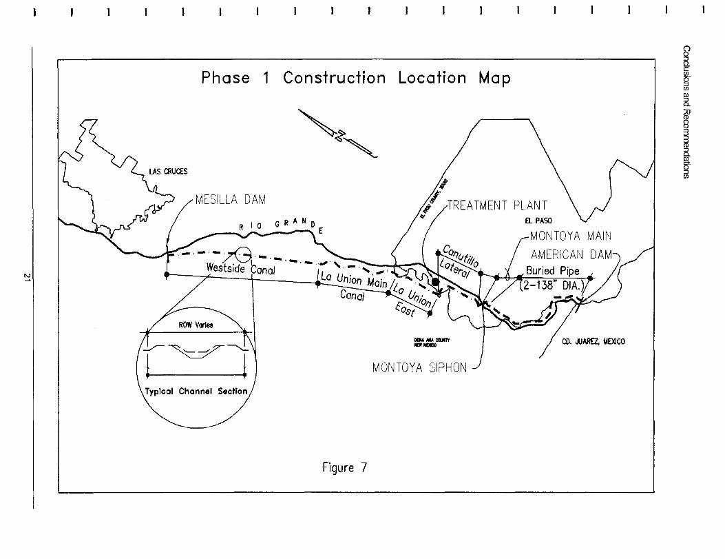
The Commision has agreed that the first phase should be what is described below as Phase 1 (see Figure 7), which covers approximately one-third of the Project reach.
There is an existing canal system which diverts Project water from the River at the Mesilla Diversion Dam and takes it all the way to the Montoya Main Lateral in EI Paso. The system begins in the Elephant Butte Irrigation District (EBID) boundaries and is operated by EBID up to near the Texas state line where it is taken over by El Paso County Water Improvement District No.1 (EPCWID#l). The Commission believes that there are several advantages to improving this existing conveyance system as Phase 1 of the Project. For example, the current system allows the use of existing rights-of-way, eliminating expense and time of condemnation. Use of the existing canal system also reduces construction costs and environmental impacts.
The specific alignment of Phase 1 will be developed as part of the detailed engineering/planning and design stage for Phase 1. It is anticipated, however, that the design would use the existing conveyance system as described as follows.
20
'" ~
Phase 1 Construction Location Map
MESILLA DAM
~~,
_ .... CQIITI
_lOCO
MONTOYA SIPHON
Figure 7
~ &i (5. :J en Dl
~
§ ~ :J
fir "" ~
Conclusions and Recommendations
The majority of the water going from the Mesilla Diversion Dam to the EPCWID#1 and its customers would continue to be diverted into the Westside Canal system. This canal becomes the La Union Main Canal and subsequently divides into either the La Union East or the La Union West Canal. As is currently done, the majority of the Texas water would be kept in the La Union East Canal, and then diverted into the Canutillo Lateral. This Canutillo Lateral would continue to transport the water all the way to the Montoya Main Lateral. At a point upstream of the existing EI Paso Electrical Plant, in the non-irrigation season, the water would be transported by a new pipeline several miles to the American Canal.
From the American Canal, the new American Canal Extension will be used to transport the water all the way to the Jonathan Rogers Water Treatment Plant. This Phase 1 description is estimated to be 38 miles of canal, and encompasses the area of greatest degradation of river water quality in the entire 100-river-mile Project area.
The planning for this Phase 1 will address the enlargement and improvement of this conveyance system, as well as the feasibility of constructing a water treatment plant near Canutillo, Texas.
The phasing of the construction for Phase 1 will also be developed as part of the detailed engineering/planning and design stage, but it is anticipated that the first step would be to construct the new pipeline to connect the termination point of the Montoya Main Lateral to the American Canal heading; subsequent phases would proceed upstream from the Montoya Main Lateral until the Mesilla Dam is reached.
Cost
The conceptualleve1 cost for the first phase of the canal system and pipeline, including associated upstream flow controls and telemetry, check dams, bridges, and turnouts, is approximately $134 million.
The proposed Canutillo Area Water Treatment Plant with a first stage capacity of20 million gallons per day to serve EI Paso's upper valley and southern New Mexico, including pipes, pumping, and storage reservoirs, is estimated to be $36 million. Thus, the total Phase 1 cost estimate is $170 million.
22
Condusions and Recommendations
Next Step
If capacity were included in the water treatment plant to contract to treat Mexico's full 60,000 acre feet allotment and pipe it to the international boundary, the additional cost for the approximate 60 million gallons per day increase is estimated at $65 million.
Benefits from Phase 1
The Commission believes that Phase 1 would achieve the following immediate results:
• Increase the operational efficiencies of the project water delivery system for both Irrigation Districts.
• Conserve water through improvements to the existing conveyance channel.
• Provide the City ofEI Paso and agricultural users with year-round supply.
• Provide the City ofEI Paso and EPCWID#1 with improved water quality.
• Allow for additional capacity for conjunctive use of water for current Texas M&I use, and future New Mexico M&I use.
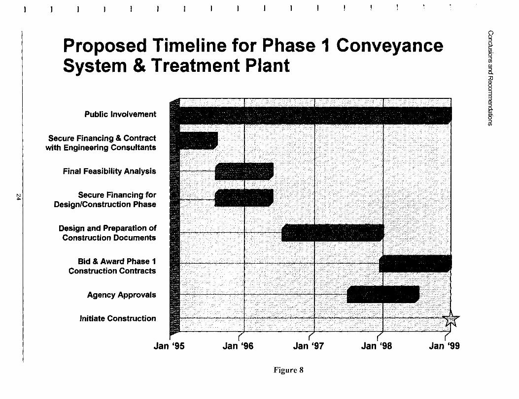
The Preliminary Planning for the Project has now been completed. Figure 8 reflects the timeline for taking the Project from January 1995 to the start of construction. The Commission must first secure the financing for the engineering consultants to prepare the design criteria for Phase 1. In addition, agreements must be reached among the water users concerning the financing, use, and management of the system. The Final Feasibility Analysis should be completed by June 1996. Subsequently, the Commission must secure the financing for the design and construction phase of Phase 1, which it should accomplish by June 1996. The Design and Preparation of Construction Documents should be completed by January 1998. The Phase 1 specifications can then be put out to bid, the bid awarded, and construction initiated by January 1999. As reflected on Figure 8, public participation continues throughout the Project through the monthly Commission meetings.
23
Proposed Timeline for Phase 1 Conveyance System & Treatment Plant
Public Involvement
Secure Financing & Contract with Engineering Consultants
Final Feasibility Analysis
~ I Secure Financing for Design/Construction Phase
Design and Preparation of Construction Documents
Bid & Award Phase 1 Construction Contracts
Agency Approvals
Initiate Construction
Jan '95 Jan '96 Jan '97 Jan '98 Jan '99
Figure 8
~ Q. c
g' en ru 5.
~ ~ fit 8' ~


![[Slide] Containment Conjunctive Queries](https://img.pdfslide.us/doc/110x75/5695d2de1a28ab9b029c044a/slide-containment-conjunctive-queries.jpg)