Embed Size (px)
Citation preview
Prepared by:Joshua G. Cohen
Michigan Natural Features InventoryP.O. Box 13036
Lansing, MI 48901-3036
For:Michigan Department of Natural Resources
Parks and Recreation Division
February 28, 2014
Report Number 2014-04
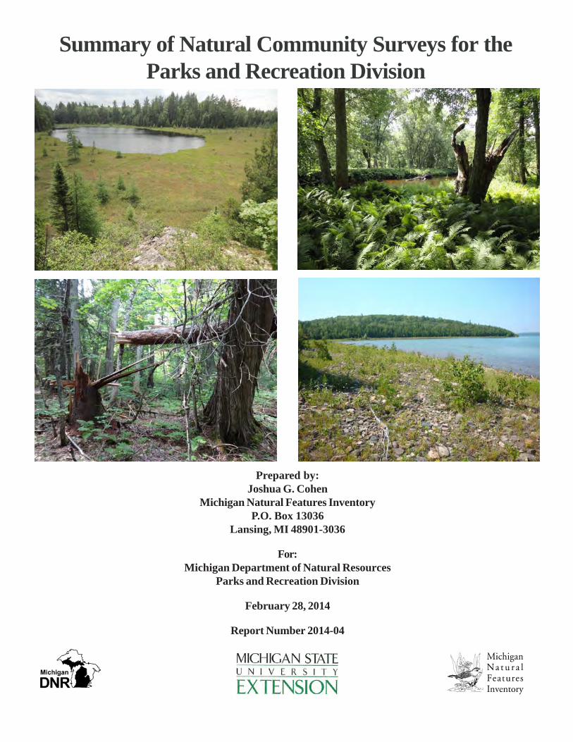
Summary of Natural Community Surveys for theParks and Recreation Division

Suggested Citation: Cohen, J.G. 2014. Summary of Natural Community Surveys for Parks and Recreation Division.Michigan Natural Features Inventory, Report Number 2014-04, Lansing, MI. 101 pp.
Copyright 2014 Michigan State University Board of Trustees.
Michigan State University Extension programs and materials are open to all without regard to race, color, national origin,gender, religion, age, disability, political beliefs, sexual orientation, marital status, or family status.
Cover photos: top left, Craig Lake Bogs from Craig Lake State Park; top right, Menominee River Floodplain fromMenominiee River State Recreation Area; lower left, Carp River Swamp South hardwood-conifer swamp from PorcupineMountains Wilderness State Park; and lower right, Lime Island limestone cobble shore from Lime Island State RecreationArea. Photos by Joshua G. Cohen.

Summary of Natural Community Surveys, Page i
TABLE OF CONTENTS
ACKNOWLEDGMENTS.......................................................................................1INTRODUCTION...................................................................................................2METHODS...............................................................................................................3
Field Surveys.................................................................................................3RESULTS.................................................................................................................4
Site Summaries.............................................................................................7BOG.....................................................................................................7
Craig Lake Bogs.........................................................................8Keweenaw Point.............................................................................9Little Carp River Bog...................................................................10
BOREAL FOREST................................................................................11Fish Cove......................................................................................12Lime Island...................................................................................13
DRY-MESIC NORTHERN FOREST..................................................14Piers Gorge Forest.......................................................................15
EMERGENT MARSH..........................................................................16Keweenaw Point...........................................................................17Middle Lake Marsh......................................................................18
FLOODPLAIN FOREST......................................................................19Menominee River Floodplain......................................................20
GRANITE BEDROCK GLADE...........................................................21Craig Lake Glades.......................................................................22
GRANITE CLIFF...................................................................................23Craig Lake Cliffs..........................................................................24
GREAT LAKES MARSH......................................................................25Lime Island...................................................................................26
HARDWOOD-CONIFER SWAMP......................................................27Carp River Swamp South.............................................................28Craig Lake Swamp......................................................................29Little Carp River Swamp.............................................................30Mirror Lake Swamp.....................................................................31Union Creek Swamp....................................................................32
HILLSIDE PRAIRIE.............................................................................33Menominee River Prairie.............................................................34
INTERDUNAL WETLAND..................................................................35Besser Natural Area.....................................................................36Rockport South............................................................................37

Summary of Natural Community Surveys, Page ii
TABLE OF CONTENTS
RESULTS(continued)Site Summaries (continued)
LIMESTONE COBBLE SHORE.........................................................38Besser Natural Area.....................................................................39Lime Island...................................................................................40Rockport South............................................................................41
MUSKEG...........................................................................................42Craig Lake Muskegs....................................................................43
NORTHERN FEN.................................................................................44Ferrion Point Fen.........................................................................45Keweenaw Point...........................................................................46Middle Lake Fen...........................................................................47
NORTHERN HARDWOOD SWAMP.................................................48Government Peak Swamp............................................................49Lake of the Clouds Swamp...........................................................50Rockport Swamp..........................................................................51
NORTHERN SHRUB THICKET.........................................................52Pesheke River Thicket.................................................................53
NORTHERN WET MEADOW.............................................................54Little Carp River Meadow...........................................................55Pesheke River Meadow.............................................................56
OAK-PINE BARRENS........................................................................57Menominee River Barrens.........................................................58
OPEN DUNES......................................................................................59Besser Natural Area...................................................................60
POOR CONIFER SWAMP.................................................................61Craig Lake Spruce Swamp........................................................62
POOR FEN...........................................................................................63Craig Lake Fens.........................................................................64
RICH CONIFER SWAMP..................................................................65Hoar Creek Swamp....................................................................66Menominee River Swamp..........................................................67Pesheke River Swamp...............................................................68
SUBMERGENT MARSH...................................................................69Keweenaw Point.........................................................................70Mirror Lake Trail.......................................................................71

Summary of Natural Community Surveys, Page iii
TABLE OF CONTENTSRESULTS(continued)
Site Summaries (continued)VOLCANIC BEDROCK GLADE.......................................................72
Brandts Creek Glade..................................................................73East Vista Glade..........................................................................74Menominee River Glade.............................................................75
VOLCANIC CLIFF...............................................................................76Porcupine South..........................................................................77Union Creek Cliff........................................................................78
VOLCANIC COBBLE SHORE...........................................................79Keweenaw Point...........................................................................80
VOLCANIC LAKESHORE CLIFF.....................................................81Fish Cove......................................................................................82
WET-MESIC FLATWOODS...............................................................83Belle Isle Flatwoods.....................................................................84
DISCUSSION............................................................................................................86REFERENCES.....................................................................................................87APPENDIX 1........................................................................................................89APPENDIX 2........................................................................................................99APPENDIX 3......................................................................................................101
TABLETable 1. Summary of 2012 surveys...........................................................................5

Summary of Natural Community Surveys, Page 1
ACKNOWLEDGMENTSWe thank the Michigan Department of Natural Resources (DNR) Parks and Recreation Division (PRD) forfunding this effort to survey for high-quality natural communities in Michigan’s State Parks and RecreationAreas. Special thanks are due to PRD’s Ray Fahlsing and Glenn Palmgren for overseeing this project. Glennwas instrumental in the development of the workplan and the Threat Assessment Form. This report relies ondata collected by many present and former Michigan Natural Features Inventory (MNFI) field scientists,especially: Joshua Cohen, Bradford Slaughter, Mike Penskar, and Suzan Campbell. Editorial support andinsightful comments were provided by Martha Gove. Finally, we thank the following MNFI colleagues: KraigKorroch and Rebecca Rogers assisted with database management; Helen Enander offered technologicalsupport; and Sue Ridge, Nancy Toben, Yu Man Lee, and Brian Klatt provided administrative support.
Summary of Natural Community Surveys, Page 2
INTRODUCTION
The Michigan Department of Natural Resources (DNR), Parks and Recreation Division (PRD) is responsiblefor managing Michigan’s State Parks, Recreation Areas, Boating Access Sites, Harbors, Scenic Sites, StateForest Campgrounds, and Pathways. Part of PRD’s stated mission is to “acquire, protect, and preserve thenatural, historic, and cultural features of Michigan’s unique resources.” Within the division, the StewardshipUnit is charged with preserving, protecting, and restoring the natural and cultural features. Preservation andrestoration of the natural communities within State Parks and Recreation Areas, along with their constituentplants and animals, are core parts of the mission. The PRD is in the process of writing and updatingmanagement plans for State Parks and Recreation Areas. In these plans, the land is zoned for various levelsof protection and use based on the location and type of its natural and cultural features.
A baseline inventory of rare natural communities was conducted by Michigan Natural Features Inventory(MNFI) in State Parks and Recreation Areas in the late 1990s to early 2000s. However, this initial inventoryeffort did not include comprehensive boundary mapping, detailed condition assessments, threat assessments,or surveys of common natural communities. To inform the PRD management planning process and the overallprotection, preservation, and restoration of natural communities throughout Michigan’s State Parks andRecreation Areas, up-to-date information is needed on the boundaries, condition, landscape context, andcurrent threats to the ecological integrity of natural communities. From 2009 to 2012, Michigan NaturalFeatures Inventory (MNFI) conducted a multi-year survey and assessment on state park and recreation arealands of known natural community element occurrences. During the course of these surveys, ecologistsidentified additional potential high-quality natural communities in many of the larger parks (i.e., PorcupineMountains Wilderness State Park and Craig Lake State Parks). In addition, the PRD has recently acquirednumerous lands that have yet to be evaluated or fully evaluated for high-quality natural communities (i.e.,Lime Island State Recreation Area, Menominee River State Recreation Area and Rockport State Park).Through work on this project, MNFI conducted surveys for high-quality natural communities in the followingPRD lands: Porcupine Mountains Wilderness State Park, Craig Lake State Park, Lime Island StateRecreation Area, Menominee River State Recreation Area, and Rockport State Park. Current state forestland along the Keweenaw Point in the Baraga State Forest Management Unit that will likely be transferred toPRD ownership was also surveyed. In addition, portions of Belle Isle Park surveyed in the fall of 2012 werealso surveyed in the growing season of 2013 for this project.
A natural community is defined as an assemblage of interacting plants, animals, and other organisms thatrepeatedly occurs under similar environmental conditions across the landscape and is predominantlystructured by natural processes rather than modern anthropogenic disturbances. Protecting and managingrepresentative natural communities is critical to biodiversity conservation, since native organisms are bestadapted to environmental and biotic forces with which they have survived and evolved over the millennia(Kost et al. 2007).
During the summer of 2013, MNFI scientists documented 44 new high-quality natural communities on StatePark and Recreation Area lands and also updated six known high-quality community element occurrences.According to MNFI’s natural community classification, there are 77 natural community types in Michigan(Kost et al. 2007). Twenty-eight different natural community types are represented in the 50 elementoccurrences surveyed (Table 1). Surveys assessed the current ranking, classification, and delineation of theseoccurrences and detailed the vegetative structure and composition, ecological boundaries, landscape andabiotic context, threats, management needs, and restoration opportunities. The primary goal of this surveyeffort is to provide resource managers and planners with standardized, baseline information on each naturalcommunity element occurrence. This baseline information is critical for facilitating site-level decisions aboutbiodiversity stewardship, prioritizing protection, management and restoration, monitoring the success ofmanagement and restoration, and informing landscape-level biodiversity planning efforts. This reportsummarizes the findings of MNFI’s ecological surveys.
Summary of Natural Community Surveys, Page 3
METHODSField SurveysThe 50 high-quality natural communities were documented in six different State Parks, State RecreationAreas, or State Forests (Table 1) including the following: Baraga State Forest Management Unit (9 sites,Keweenaw Point), Belle Isle Park (1 site), Craig Lake State Park (10 sites), Lime Island State RecreationArea (3 sites), Menominee River State Recreation Area (7 sites), Porcupine Mountains Wilderness StatePark (11 sites), and Rockport State Park (9 sites). These sites were made a priority for survey for one ormore of the following reasons: Phase 1 of the Living Legacies initiative or Biodiversity Planning Processidentified these areas as potential Biodiversity Stewardship Areas; surveys had not been conducted withinthese areas; PRD was in the process of writing management plans for these areas; and/or limited informationhad been recorded about the sites or the natural community types within the sites. In addition, naturalcommunities that were undersurveyed and/or underrepresented across the state and regionally wereprioritized.
Each natural community was evaluated employing Natural Heritage and MNFI methodology, which considersthree factors to assess a natural community’s ecological integrity or quality: size, landscape context, andcondition (Faber-Langendoen et al. 2008). If a site meets defined requirements for these three criteria (MNFI1988) it is categorized as a high-quality example of that specific natural community type, entered into MNFI’sdatabase as an element occurrence, and given a rank based on the consideration of its size, landscapecontext, and condition. Ecological field surveys were conducted during the growing season to evaluate thecondition and classification of the sites. To assess natural community size and landscape context, acombination of field surveys, aerial photographic interpretation, and Geographic Information System (GIS)analysis was employed. Typically, a minimum of a half day was dedicated to each site, depending on the sizeand complexity of the site. For sites that occur on multiple ownerships, surveys were restricted to PRDportions of the occurrences unless permission was granted to access other ownerships.
For each site visited, an Ecological Community Field Survey Form (Appendix 1) and a Threat AssessmentForm (Appendix 2) were completed. The Threat Assessment Form allows for the scoring of each observedthreat in terms of severity, scope, and reversibility. For the purposes of this form, severity was defined as thelevel of damage to the site caused by the threat, scope was defined as the geographic extent of impact of thethreat, and reversibility was defined as the probability of controlling the threat and reversing the damage.
The ecological field surveys typically involved:
a) compiling comprehensive plant species lists and noting dominant and representative speciesb) describing site-specific structural attributes and ecological processesc) measuring tree diameter at breast height (DBH) of representative canopy trees and aging canopy
dominants (where appropriate)d) analyzing soils and hydrologye) noting current and historical anthropogenic disturbancesf) evaluating potential threats (using the Threat Assessment Form, each observed threat was ranked in
terms of its severity, scope, and reversibility, and scores for these categories were summed togenerate an overall threat score)
g) ground-truthing aerial photographic interpretation using GPS (Garmin and HP iPAQ units wereutilized)
h) taking digital photos and GPS points at significant locationsi) surveying adjacent lands when possible to assess landscape contextj) evaluating the natural community classification and mapped ecological boundariesk) assigning or updating element occurrence ranksl) noting management needs and restoration opportunities or evaluating past and current restoration
activities and noting additional management needs and restoration opportunities

Summary of Natural Community Surveys, Page 4
Following completion of the field surveys, the collected data were analyzed and transcribed to update orcreate element occurrence records in MNFI’s statewide biodiversity conservation database (MNFI 2014).Natural community boundaries were mapped or re-mapped. Information from these surveys and priorsurveys, if available, was used to produce threat assessments and management recommendations for eachnatural community occurrence, which appear within the following Results section.
RESULTSThe 50 occurrences of high-quality natural communities were surveyed during the 2013 field season. As notedabove, the 50 sites surveyed were within six different State Parks, State Recreation Areas, or State Forests(see above and Table 1). A total of thirty-nine different natural communities were visited including: bog (3element occurrences or EOs), boreal forest (2 EOs), dry-mesic northern forest (1 EO), emergent marsh (2EOs), floodplain forest (1 EO), granite bedrock glade (1 EO), granite cliff (1 EO), Great Lakes marsh (1 EO),hardwood-conifer swamp (5 EOs), hillside prairie (1 EO), interdunal wetland (2 EOs), limestone cobble shore(3 EOs), muskeg (1 EO), northern fen (3 EOs), northern hardwood swamp (3 EOs), northern shrub thicket (1EO), northern wet meadow (2 EOs), oak-pine barrens (1 EO), open dunes (1 EO), poor conifer swamp (1EO), poor fen (1 EO), rich conifer swamp (3 EOs), submergent marsh (2 EOs), volcanic bedrock glade (3EOs), volcanic cliff (2 EOs), volcanic cobble shore (1 EO), volcanic lakeshore cliff (1 EO), and wet-mesicflatwoods (1 EO). Table 1 lists the visited sites, their element occurrence ranks, and their previous elementoccurrence ranks if applicable.
The following site summaries contain a detailed discussion for each of these 50 natural communities organizedalphabetically by community type and then by element occurrence. The beginning of each grouping ofcommunities contains an overview of the natural community type, which was adapted from MNFI’s naturalcommunity classification (Kost et al. 2007). In addition, an ecoregional distribution map is provided for eachnatural community type (Albert et al. 2008). For each site summary, the following information is provided:
a) site nameb) natural community typec) global and state rank (see Appendix 3 for ranking criteria)d) current element occurrence ranke) sizef) locational informationg) digital photograph(s)h) threat assessmenti) management recommendations

Summary of Natural Community Surveys, Page 5
Tab
le 1
. Sum
mar
y of
Nat
ural
Com
mun
ity S
urve
ys (
* in
dica
tes
elem
ent o
ccur
renc
es th
at w
ere
upda
ted.
Whe
re a
pplic
able
, old
elem
ent o
ccur
renc
e ra
nkin
gs p
rovi
ded
in p
aran
thes
es).
Com
mun
ity
Typ
eE
O I
DC
ount
ySu
rvey
Sit
eM
anag
emen
t A
rea
EO
RA
NK
Surv
eyor
Bog
1974
9K
ewee
naw
Kew
eena
w P
oint
Bar
aga
Stat
e Fo
rest
Man
agem
ent U
nit
(Kew
eena
w P
oint
)B
J. C
ohen
Bog
1975
8B
arag
aC
raig
Lak
e B
ogs
Cra
ig L
ake
Stat
e Pa
rkA
BJ.
Coh
en
Bog
1976
6O
nton
agon
Litt
le C
arp
Riv
er B
ogPo
rcup
ine
Mou
ntai
ns W
ilder
ness
Sta
te
Park
CD
J. C
ohen
Bor
eal F
ores
t19
752
Kew
eena
wFi
sh C
ove
Bar
aga
Stat
e Fo
rest
Man
agem
ent U
nit
(Kew
eena
w P
oint
)A
BJ.
Coh
enB
orea
l For
est
1973
1C
hipp
ewa
Lim
e Is
land
Lim
e Is
land
Sta
te R
ecre
atio
n A
rea
BC
J. C
ohen
& M
. Pen
skar
Dry
-Mes
ic N
orth
ern
Fore
st19
741
Dic
kins
onPi
ers
Gor
ge F
ores
tM
enom
inee
Riv
er S
tate
Rec
reat
ion
Are
aC
J. C
ohen
Em
erge
nt M
arsh
1975
4K
ewee
naw
Kew
eena
w P
oint
Bar
aga
Stat
e Fo
rest
Man
agem
ent U
nit
(Kew
eena
w P
oint
)B
J. C
ohen
Em
erge
nt M
arsh
1974
3A
lpen
aM
iddl
e L
ake
Mar
shR
ockp
ort S
tate
Par
kB
J. C
ohen
& M
. Pen
skar
Floo
dpla
in F
ores
t19
738
Men
omin
eeM
enom
inee
Riv
er F
lood
plai
nM
enom
inee
Riv
er S
tate
Rec
reat
ion
Are
aC
J. C
ohen
& M
. Pen
skar
Gra
nite
Bed
rock
Gla
de19
760
Bar
aga
Cra
ig L
ake
Gla
des
Cra
ig L
ake
Stat
e Pa
rkB
J. C
ohen
Gra
nite
Clif
f19
757
Bar
aga
Cra
ig L
ake
Clif
fsC
raig
Lak
e St
ate
Park
BJ.
Coh
enG
reat
Lak
es M
arsh
1973
2C
hipp
ewa
Lim
e Is
land
Lim
e Is
land
Sta
te R
ecre
atio
n A
rea
BJ.
Coh
en &
M. P
ensk
arH
ardw
ood-
Con
ifer
Sw
amp
1976
1B
arag
aC
raig
Lak
e Sw
amp
Cra
ig L
ake
Stat
e Pa
rkB
J. C
ohen
Har
dwoo
d-C
onif
er S
wam
p19
767
Ont
onag
onM
irro
r L
ake
Swam
pPo
rcup
ine
Mou
ntai
ns W
ilder
ness
Sta
te
Park
AB
J. C
ohen
Har
dwoo
d-C
onif
er S
wam
p19
768
Ont
onag
onC
arp
Riv
er S
wam
p So
uth
Porc
upin
e M
ount
ains
Wild
erne
ss S
tate
Pa
rkA
BJ.
Coh
en
Har
dwoo
d-C
onif
er S
wam
p19
769
Ont
onag
onL
ittle
Car
p R
iver
Sw
amp
Porc
upin
e M
ount
ains
Wild
erne
ss S
tate
Pa
rkB
J. C
ohen
Har
dwoo
d-C
onif
er S
wam
p19
770
Ont
onag
onU
nion
Cre
ek S
wam
pPo
rcup
ine
Mou
ntai
ns W
ilder
ness
Sta
te
Park
BJ.
Coh
en
Hill
side
Pra
irie
1973
7M
enom
inee
Men
omin
ee R
iver
Pra
irie
Men
omin
ee R
iver
Sta
te R
ecre
atio
n A
rea
CJ.
Coh
en &
M. P
ensk
arIn
terd
unal
Wet
land
*18
757
Pres
que
Isle
Bes
ser
Nat
ural
Are
aR
ockp
ort S
tate
Par
kB
CJ.
Coh
en &
M. P
ensk
arIn
terd
unal
Wet
land
1974
4A
lpen
aR
ockp
ort S
outh
Roc
kpor
t Sta
te P
ark
BC
J. C
ohen
& M
. Pen
skar
Lim
esto
ne C
obbl
e Sh
ore
1974
8C
hipp
ewa
Lim
e Is
land
Lim
e Is
land
Sta
te R
ecre
atio
n A
rea
BJ.
Coh
en &
M. P
ensk
arL
imes
tone
Cob
ble
Shor
e*18
759
Pres
que
Isle
Bes
ser
Nat
ural
Are
aR
ockp
ort S
tate
Par
kB
(A
B)
J. C
ohen
& M
. Pen
skar
Lim
esto
ne C
obbl
e Sh
ore
1974
5A
lpen
aR
ockp
ort S
outh
Roc
kpor
t Sta
te P
ark
BC
J. C
ohen
& M
. Pen
skar
Mus
keg
1975
6B
arag
aC
raig
Lak
e M
uske
gsC
raig
Lak
e St
ate
Park
AB
J. C
ohen
Nor
ther
n Fe
n*17
279
Kew
eena
wK
ewee
naw
Poi
ntB
arag
a St
ate
Fore
st M
anag
emen
t Uni
t (K
ewee
naw
Poi
nt)
AB
J. C
ohen

Summary of Natural Community Surveys, Page 6
Tab
le 1
(co
ntin
ued)
. Sum
mar
y of
Nat
ural
Com
mun
ity S
urve
ys (
* in
dica
tes
elem
ent o
ccur
renc
e th
at w
ere
upda
ted.
Whe
re a
pplic
able
, old
elem
ent o
ccur
renc
e ra
nkin
gs p
rovi
ded
in p
aran
thes
es).
Com
mun
ity
Typ
eE
O I
DC
ount
ySu
rvey
Sit
eM
anag
emen
t A
rea
EO
RA
NK
Surv
eyor
Nor
ther
n Fe
n19
742
Alp
ena
Mid
dle
Lak
e Fe
nR
ockp
ort S
tate
Par
kB
J. C
ohen
& M
. Pen
skar
Nor
ther
n Fe
n19
746
Pres
que
Isle
Ferr
ion
Poin
t Fen
Roc
kpor
t Sta
te P
ark
BC
J. C
ohen
& M
. Pen
skar
Nor
ther
n H
ardw
ood
Swam
p19
771
Ont
onag
onG
over
nmen
t Pea
k Sw
amp
Porc
upin
e M
ount
ains
Wild
erne
ss S
tate
Pa
r kA
BJ.
Coh
en
Nor
ther
n H
ardw
ood
Swam
p19
772
Ont
onag
onL
ake
of th
e C
loud
s Sw
amp
Porc
upin
e M
ount
ains
Wild
erne
ss S
tate
Pa
r kA
BJ.
Coh
enN
orth
ern
Har
dwoo
d Sw
amp
1974
7Pr
esqu
e Is
leR
ockp
ort S
wam
pR
ockp
ort S
tate
Par
kB
CJ.
Coh
enN
orth
ern
Shru
b T
hick
et19
764
Bar
aga
Pesh
eke
Riv
er T
hick
etC
raig
Lak
e St
ate
Par k
AB
J. C
ohen
Nor
ther
n W
et M
eado
w19
765
Bar
aga
Pesh
eke
Riv
er M
eado
wC
raig
Lak
e St
ate
Par k
BJ.
Coh
en
Nor
ther
n W
et M
eado
w19
774
Ont
onag
onL
ittle
Car
p R
iver
Mea
dow
Porc
upin
e M
ount
ains
Wild
erne
ss S
tate
Pa
r kA
BJ.
Coh
en
Oak
-Pin
e B
arre
ns19
740
Men
omin
eeM
enom
inee
Riv
er B
arre
nsM
enom
inee
Riv
er S
tate
Rec
reat
ion
Are
aC
DJ.
Coh
en &
M. P
ensk
arO
pen
Dun
es*
1875
8Pr
esqu
e Is
leB
esse
r N
atur
al A
rea
Roc
kpor
t Sta
te P
ark
BC
J. C
ohen
& M
. Pen
skar
Poor
Con
ifer
Sw
amp
1976
2B
arag
aC
raig
Lak
e Sp
ruce
Sw
amp
Cra
ig L
ake
Stat
e Pa
r kB
J. C
ohen
Poor
Fen
1975
9B
arag
aC
raig
Lak
e Fe
nsC
raig
Lak
e St
ate
Par k
BJ.
Coh
en
Ric
h C
onif
er S
wam
p19
751
Kew
eena
wH
oar
Cre
ek S
wam
pB
arag
a St
ate
Fore
st M
anag
emen
t Uni
t (K
ewee
naw
Poi
nt)
AB
J. C
ohen
Ric
h C
onif
er S
wam
p19
763
Bar
aga
Pesh
eke
Riv
er S
wam
pC
raig
Lak
e St
ate
Par k
BC
J. C
ohen
Ric
h C
onif
er S
wam
p19
735
Men
omin
eeM
enom
inee
Riv
er S
wam
pM
enom
inee
Riv
er S
tate
Rec
reat
ion
Are
aC
J. C
ohen
& M
. Pen
skar
Subm
erge
nt M
arsh
1975
3K
ewee
naw
Kew
eena
w P
oint
Bar
aga
Stat
e Fo
rest
Man
agem
ent U
nit
(Kew
eena
w P
oint
)A
BJ.
Coh
en
Subm
erge
nt M
arsh
1977
5O
nton
agon
Mir
ror
Lak
e T
rail
Porc
upin
e M
ount
ains
Wild
erne
ss S
tate
Pa
r kA
BJ.
Coh
en
Vol
cani
c B
edro
ck G
lade
1973
6M
enom
inee
Men
omin
ee R
iver
Gla
deM
enom
inee
Riv
er S
tate
Rec
reat
ion
Are
aB
CJ.
Coh
en &
M. P
ensk
ar
Vol
cani
c B
edro
ck G
lade
1973
9M
enom
inee
Bra
ndts
Cre
ek G
lade
Men
omin
ee R
iver
Sta
te R
ecre
atio
n A
rea
CD
J. C
ohen
Vol
cani
c B
edro
ck G
lade
1977
6O
nton
agon
Eas
t Vis
ta G
lade
Porc
upin
e M
ount
ains
Wild
erne
ss S
tate
Pa
r kC
J. C
ohen
Vol
cani
c C
liff
1975
5K
ewee
naw
Uni
on C
reek
Clif
fB
arag
a St
ate
Fore
st M
anag
emen
t Uni
t (K
ewee
naw
Poi
nt)
BJ.
Coh
en
Vol
cani
c C
liff
1977
3O
nton
agon
Porc
upin
e So
uth
Porc
upin
e M
ount
ains
Wild
erne
ss S
tate
Pa
r kA
BJ.
Coh
en
Vol
cani
c C
obbl
e Sh
ore*
1728
0K
ewee
naw
Kew
eena
w P
oint
Bar
aga
Stat
e Fo
rest
Man
agem
ent U
nit
(Kew
eena
w P
oint
)A
J. C
ohen
Vol
cani
c L
akes
hore
Clif
f19
750
Kew
eena
wFi
sh C
ove
Bar
aga
Stat
e Fo
rest
Man
agem
ent U
nit
(Kew
eena
w P
oint
)A
BJ.
Coh
enW
et-M
esic
Fla
twoo
d19
059
Way
neB
elle
Isl
e Fl
atw
oods
Bel
le I
sle
Par k
DJ.
Coh
en, B
. Sla
ught
er, &
S. C
ampb
ell

Summary of Natural Community Surveys, Page 7
SITE SUMMARIES
BOG
Bog is a nutrient-poor peatland characterized by acidic, saturated peat and the prevalence of sphagnum mosses andericaceous shrubs. Located in depressions in glacial outwash and sandy glacial lakeplains and in kettles on pittedoutwash and moraines, bogs frequently occur as a floating mat on the margins of lakes and ponds. Fire occursnaturally during drought periods and can alter the hydrology, mat surface, and flora. Beaver-induced flooding alsoinfluences bogs (Kost et al. 2007).
Figure 1. Distribution of bogs in Michigan.

Summary of Natural Community Surveys, Page 8
Photo 1. Craig Lake Bogs. Photo by Joshua G. Cohen.
1. Craig Lake BogsNatural Community Type: BogRank: G3G5 S4, vulnerable to secure globally and secure within the stateElement Occurrence Rank: ABSize: 66 acresLocation: Craig Lake State ParkElement Occurrence Identification Number: 19758
Threats: Species composition and structure driven by natural processes. Fire suppression throughout the generallandscape may have altered the fire regime of the bog.
Management Recommendations: The main management recommendations are to allow natural processes tooperate unhindered and to retain an intact buffer of natural communities surrounding the wetland to minimize thethreat of hydrological alteration. In the event of a wildfire, establishment of new fire lines should be avoided andexisting fire breaks (i.e., trails, roads, and wetlands) should be used.

Summary of Natural Community Surveys, Page 9
2. Keweenaw PointNatural Community Type: BogRank: G3G5 S4, vulnerable to secure globally and secure within the stateElement Occurrence Rank: BSize: 4 acresLocation: Baraga State Forest Management UnitElement Occurrence Identification Number: 19749
Threats: The bog is characterized by low species diversity but the species composition and structure aredriven by natural processes. No anthropogenic disturbances or non-native species were noted during thecourse of the survey. Logging in the surrounding forest could alter the hydrology of the bog.
Management Recommendations: The main management recommendations are to allow natural processesto operate unhindered and to retain an intact buffer of natural communities surrounding the bog to minimizethe threat of hydrological alteration. In the event of a wildfire, establishment of new fire lines should beavoided and existing fire breaks (i.e., trails and wetlands) should be used.
Photo 2. Keweenaw Point. Photo by Joshua G. Cohen.

Summary of Natural Community Surveys, Page 10
3. Little Carp River BogNatural Community Type: BogRank: G3G5 S4, vulnerable to secure globally and secure within the stateElement Occurrence Rank: CSize: 0.6 acresLocation: Porcupine Mountains Wilderness State ParkElement Occurrence Identification Number: 19766
Threats: No anthropogenic disturbances or non-native species were noted during the course of the survey.Species composition and structure driven by natural processes.
Management Recommendations: The main management recommendations are to allow natural processesto operate unhindered and to retain an intact buffer of natural communities surrounding the bog to minimizethe threat of hydrological alteration. In the event of a wildfire, establishment of new fire lines should beavoided and existing fire breaks (i.e., trails and wetlands) should be used.
Photo 3. Little Carp River Bog. Photo by Joshua G. Cohen.

Summary of Natural Community Surveys, Page 11
BOREAL FOREST
Overview: Boreal forest is a conifer or conifer-hardwood forest type occurring on moist to dry sites characterizedby species dominant in the Canadian boreal forest. It typically occupies upland sites along shores of the GreatLakes, on islands in the Great Lakes, and locally inland. The community occurs north of the climatic tension zoneprimarily on sand dunes, glacial lakeplains, and thin soil over bedrock or cobble. Soils of sand and sandy loam aretypically moderately acid to neutral, but heavier soils and more acid conditions are common. Proximity to the GreatLakes results in high levels of windthrow and climatic conditions characterized by low summer temperatures andhigh levels of humidity, snowfall, and summer fog and mist. Additional important forms of natural disturbanceinclude fire and insect epidemics (Kost et al. 2007).
Figure 2. Distribution of boreal forest in Michigan.

Summary of Natural Community Surveys, Page 12
Photo 4. Fish Cove Boreal Forest. Photo by Joshua G. Cohen.
4. Fish CoveNatural Community Type: Boreal ForestRank: GU S3, globally unrankable and vulnerable within the stateElement Occurrence Rank: ABSize: 55 acresLocation: Baraga State Forest Management UnitElement Occurrence Identification Number: 19752
Threats: No threats were observed during the course of the survey. Potential threats include invasive species andoff-road vehicle use. No invasive species were noted within the boreal forest. Spotted knapweed (Centaureastoebe) is locally prevalent to the west of the boreal forest in degraded volcanic bedrock glade near the mouth ofthe Montreal River. Several infrequently used food trails occur in the boreal forest near the shoreline. In addition,the frequency of off-road vehicle use has been increasing in the general area and off-road vehicle users areillegally creating new roads nearby.
Management Recommendations: The main management recommendations are to allow natural processes (i.e.,windthrow and fire) to operate unhindered and to monitor for invasive species and illegal off-road vehicle use.
Summary of Natural Community Surveys, Page 13
Photo 5. Lime Island Boreal Forest. Photo by Joshua G. Cohen.
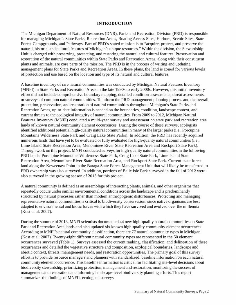
5. Lime IslandNatural Community Type: Boreal ForestRank: GU S3, globally unrankable and vulnerable within the stateElement Occurrence Rank: BCSize: 574 acresLocation: Lime Island State Recreation AreaElement Occurrence Identification Number: 19731
Threats: The species composition and structure of this boreal forest is influenced by natural processes but also bydeer herbivory. Deer browse could limit the regeneration capacity of the overstory conifers. No invasive specieswere noted within the boreal forest. However, numerous invasives are known from the shoreline including St.John’s-wort (Hypericum perforatum), spotted knapweed (Centaurea stoebe), and wild parsnip (Pastinacasativa). The linear anthropogenic disturbances (i.e., trails) within the forest could provide conduits for weeds anddeer. Several dirt roads and trails occur throughout the boreal forest and scattered cut stumps occur in portions ofthe boreal forest.
Management Recommendations: The primary management recommendations are to allow natural processes tooperate unhindered and to monitor for invasive species and deer herbivory.
Summary of Natural Community Surveys, Page 14
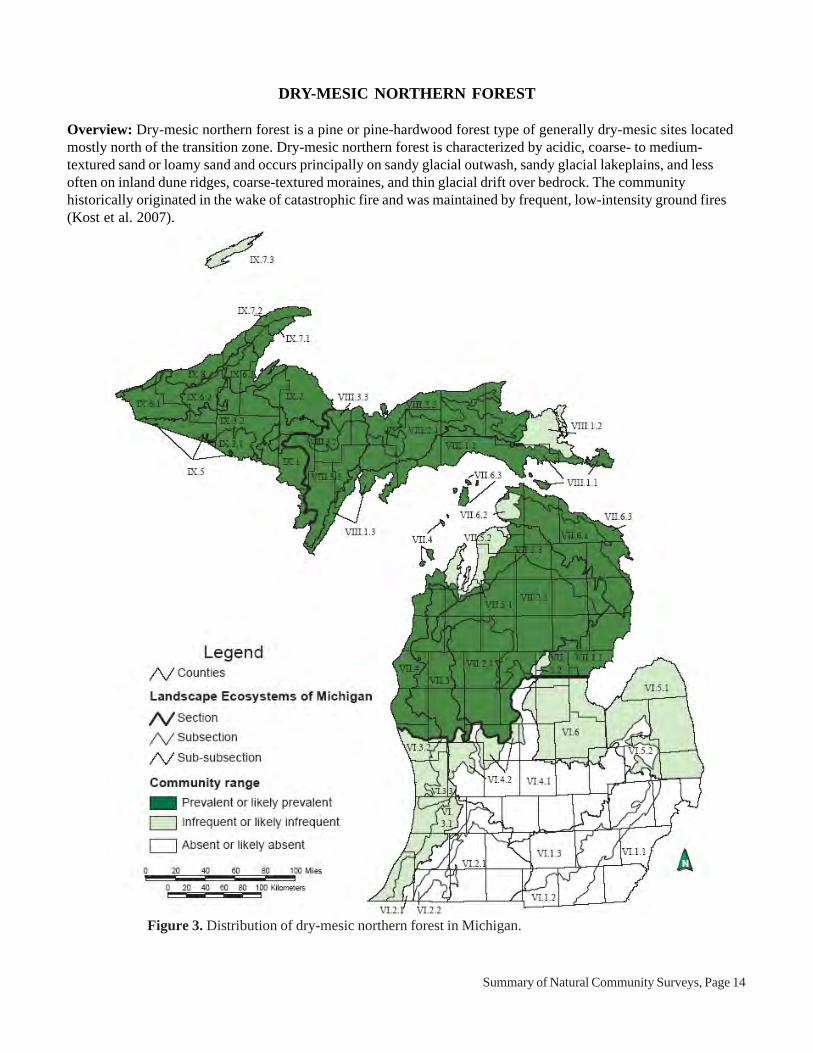
DRY-MESIC NORTHERN FOREST
Overview: Dry-mesic northern forest is a pine or pine-hardwood forest type of generally dry-mesic sites locatedmostly north of the transition zone. Dry-mesic northern forest is characterized by acidic, coarse- to medium-textured sand or loamy sand and occurs principally on sandy glacial outwash, sandy glacial lakeplains, and lessoften on inland dune ridges, coarse-textured moraines, and thin glacial drift over bedrock. The communityhistorically originated in the wake of catastrophic fire and was maintained by frequent, low-intensity ground fires(Kost et al. 2007).
Figure 3. Distribution of dry-mesic northern forest in Michigan.

Summary of Natural Community Surveys, Page 15
Photo 6. Piers Gorge Forest. Photo by Joshua G. Cohen.
6. Piers Gorge ForestNatural Community Type: Dry-mesic Northern ForestRank: G4 S3, apparently secure globally and vulnerable within the stateElement Occurrence Rank: CSize: 101 acresLocation: Menominee River State Recreation AreaElement Occurrence Identification Number: 19741
Threats: Deer herbivory has negatively impacted understory and ground cover species composition and structure.Hiking trails occur in portions of the forest and have locally caused soil erosion.
Management Recommendations: The primary management recommendation is to allow natural processes tooperate unhindered (i.e., permit wildfires to burn through this site and the surrounding volcanic bedrock glade) andto reduce local deer densities. In the event of a wildfire or if prescribed fire is implemented, establishment of newfire lines should be avoided and existing fire breaks (i.e., roads and river) should be used. Control of local deerpopulations will reduce deer browse pressure.

Summary of Natural Community Surveys, Page 16
EMERGENT MARSH
Overview: Emergent marsh is a shallow-water wetland along the shores of lakes and streams characterized byemergent narrow- and broad-leaved herbs and grass-like plants as well as floating-leaved herbs. Common plantsinclude water plantains (Alisma spp.), sedges (Carex spp.), spike-rushes (Eleocharis spp.), pond-lilies (Nupharspp.), pickerel weed (Pontederia cordata), arrowheads (Sagittaria spp.), bulrushes (Schoenoplectus spp.), andcat-tails (Typha spp.). The community occurs on both mineral and organic soils (Kost et al. 2007).
Figure 4. Distribution of emergent marsh in Michigan.

Summary of Natural Community Surveys, Page 17
Photo 7. Keweenaw Point emergent marsh. Photo by Joshua G. Cohen.
7. Keweenaw PointNatural Community Type: Emergent MarshRank: GU S4, globally unrankable and secure within the stateElement Occurrence Rank: ABSize: 6 acresLocation: Baraga State Forest Management UnitElement Occurrence Identification Number: 19754
Threats: The species composition and structure of this emergent marsh is influenced by natural processes. Noanthropogenic disturbances or non-native species were noted during the course of the survey. Logging in thesurrounding swamp and boreal forest could alter the local hydrology of the wetland.
Management Recommendations: The main management recommendations are to allow natural processes tooperate unhindered, retain an intact buffer of natural communities surrounding the wetland to minimize the threat ofhydrological alteration, and monitor for invasive plants and illegal off-road vehicle use.

Summary of Natural Community Surveys, Page 18
Photo 8. Middle Lake Marsh. Photo by Joshua G. Cohen.
8. Middle Lake MarshNatural Community Type: Emergent MarshRank: GU S4, globally unrankable and secure within the stateElement Occurrence Rank: BSize: 263 acresLocation: Rockport State ParkElement Occurrence Identification Number: 19743
Threats: The species composition and structure of this emergent marsh is influenced by natural processes. Noanthropogenic disturbances or non-native species were noted during the course of the survey. However, off-roadvehicle damage, deer browse, and scattered non-native species were noted in the adjacent northern fen.
Management Recommendations: The main management recommendations are to allow natural processes tooperate unhindered, retain an intact buffer of natural communities surrounding the wetland to minimize the threat ofhydrological alteration, and monitor for invasive plants and illegal off-road vehicle use.

Summary of Natural Community Surveys, Page 19
FLOODPLAIN FOREST
Overview: Floodplain forest is a bottomland, deciduous or deciduous-conifer forest community occupying low-lying areas adjacent to streams and rivers of third order or greater, and subject to periodic over-the-bank floodingand cycles of erosion and deposition. Species composition and community structure vary regionally and areinfluenced by flooding frequency and duration. Silver maple (Acer saccharinum) and green ash (Fraxinuspennsylvanica) are typically major overstory dominants, although green ash is declining in importance with thespread of emerald ash borer (Agrilus planipennis). Floodplain forests occur along major rivers throughout thestate, but are most extensive in the Lower Peninsula. Species richness is greatest in the southern Lower Peninsula,where many floodplain species reach the northern extent of their range (Kost et al. 2007).
Figure 5. Distribution of floodplain forest in Michigan.

Summary of Natural Community Surveys, Page 20
Photo 9. Menominee River Floodplain. Photo by Joshua G. Cohen.
9. Menominee River FloodplainNatural Community Type: Floodplain ForestRank: G3? S3, vulnerable throughout rangeElement Occurrence Rank: CSize: 27 acresLocation: Menominee River State Recreation AreaElement Occurrence Identification Number: 19738
Threats: Species composition and natural community composition are patterned by the fluvial processes of erosionand deposition. In addition to over-the-bank flooding, windthrow, logging, and deer herbivory have influenced thefloodplain forest. Scattered stumps from logging occur along the river. Deer trails, beds, and browse were notedthroughout the floodplain forest. Deer browse is prevalent on understory woody species. Portions of the floodplainforest have been degraded by off-road vehicle trails including some significant rutting of organic soils. Invasivesnoted locally in portions of the floodplain forest include reed canary grass (Phalaris arundinacea) and forget-me-not (Myosotis scorpioides).
Management Recommendations: The main management recommendations are to maintain the maturefloodplain forest and the hydrology of the river, allow the adjacent uplands to mature to provide a buffer for thefloodplain from invasive species, reduce local deer populations, eliminate off-road vehicle activity, control invasivespecies, and monitor for deer browse, invasive species, and off-road vehicle activity.

Summary of Natural Community Surveys, Page 21
GRANITE BEDROCK GLADE
Overview: Granite bedrock glade consists of an open forested or savanna community found where knobs ofgranitic bedrock types are exposed at the surface. The sparse vegetation consists of scattered open-grown trees,scattered shrubs or shrub thickets, and a partial turf of herbs, grasses, sedges, mosses, and lichens. Granite bedrockglades typically occupy areas of steep to stair-stepped slopes, with short cliffs, and exposed knobs of bedrock. Thecommunity occurs in the western Upper Peninsula with primary concentrations in Marquette, Baraga, andDickinson Counties (Kost et al. 2007).
Figure 6. Distribution of granite bedrock glade in Michigan.

Summary of Natural Community Surveys, Page 22
Photo 10. Craig Lake Glades. Photo by Joshua G. Cohen.
10. Craig Lake GladesNatural Community Type: Granite Bedrock GladeRank: GU S4, globally unrankable and secure within the stateElement Occurrence Rank: BSize: 4.7 acresLocation: Craig Lake State ParkElement Occurrence Identification Number: 19760
Threats: Species composition, vegetative structure, and successional trajectory are influenced by naturalprocesses. However, there are moderate to low levels of non-native species located within the glade includinghawkweeds (Hieracium spp.) and sheep sorrel (Rumex acetosella).
Management Recommendations: The main management recommendations are to allow natural processes tooperate unhindered (i.e., let wildfires burn) and to maintain a natural buffer surrounding the glades to prevent theincrease of a weedy seed source. Monitoring should be implemented for non-native plant populations.

Summary of Natural Community Surveys, Page 23
GRANITE CLIFF
Overview: Granite cliff consists of vertical or near-vertical exposures of bedrock with sparse coverage of vascu-lar plants, lichens, mosses, and liverworts. The community occurs in several counties of the western Upper Penin-sula, including Dickinson, Gogebic, Houghton, Iron, Marquette, and Menominee (Kost et al. 2007).
Figure 7. Distribution of granite cliff in Michigan.

Summary of Natural Community Surveys, Page 24
Photo 11. Craig Lake Cliffs. Photo by Joshua G. Cohen.
11. Craig Lake CliffsNatural Community Type: Granite CliffRank: G4G5 S2, apparently secure globally and imperiled within the stateElement Occurrence Rank: BSize: 9 acresLocation: Craig Lake State ParkElement Occurrence Identification Number: 19757
Threats: Species composition, vegetative structure, and successional trajectory are influenced by naturalprocesses. However, there are moderate to low levels of non-native species located within the adjacent granitebedrock glade including hawkweeds (Hieracium spp.) and sheep sorrel (Rumex acetosella).
Management Recommendations: The main management recommendations are to maintain a natural communitybuffer adjacent to the cliffs to minimize the threat of invasion by non-native species, and allow natural processes(i.e., fire and windthrow) to operate unhindered.

Summary of Natural Community Surveys, Page 25
GREAT LAKES MARSH
Overview: Great Lakes marsh is an herbaceous wetland community occurring statewide along the shoreline of theGreat Lakes and their major connecting rivers. Vegetational patterns are strongly influenced by water levelfluctuations and type of coastal feature, but generally include the following: a deep marsh with submerged plants;an emergent marsh of mostly narrow-leaved species; and a sedge-dominated wet meadow that is inundated bystorms. Great Lakes marsh provides important habitat for migrating and breeding waterfowl, shore-birds, spawningfish, and medium-sized mammals (Kost et al. 2007).
Figure 8. Distribution of Great Lakes marsh in Michigan.

Summary of Natural Community Surveys, Page 26
Photo 12. Lime Island Great Lakes marsh. Photo by Joshua G. Cohen.
12. Lime IslandNatural Community Type: Great Lakes MarshRank: G2 S3, globally imperiled and vulnerable within the stateElement Occurrence Rank: BSize: 65 acresLocation: Lime Island State Recreation AreaElement Occurrence Identification Number: 19732
Threats: Lime Island was formerly used as a fueling station for oil tankers travelling through the Saint MarysRiver. Many of these tankers dumped coal along the shore, especially south of the dock. Non-natives are locallycommon along the shoreline, especially south of the dock on the west side of island and include reed canary grass(Phalaris arundinacea), St. John’s-wort (Hypericum perforatum), spotted knapweed (Centaurea stoebe), wildparsnip (Pastinaca sativa), purple loosestrife (Lythrum salicaria), common mullein (Verbascum thapsus), whitesweet-clover (Melilotus alba), ox-eye daisy (Chrysanthemum leucanthemum), and Kentucky bluegrass (Poapratensis). These non-native species are primarily concentrated along the limestone cobble shore but purpleloosestrife was noted as locally common in the Great Lakes marsh. In addition, deer browse is prevalent along theshore and off-road vehicle damage was noted along the western side of the island in Great Lakes marsh
Management Recommendations: The primary management recommendations are to allow natural processes tooperate unhindered, eliminate off-road vehicle activity along the shoreline, control non-native plants along theshoreline (e.g., purple loosestrife), and to maintain a natural community buffer surrounding the shoreline to preventthe increase of the weedy seed source. Monitoring should be implemented for non-native plant populations and deerherbivory. In addition, anthropogenic debris along the shoreline could be cleaned up.

Summary of Natural Community Surveys, Page 27
HARDWOOD-CONIFER SWAMP
Overview: Hardwood-conifer swamp is a minerotrophic forested wetland dominated by a mixture of lowlandhardwoods and conifers, occurring on organic (i.e., peat) and poorly drained mineral soils throughout Michigan. Thecommunity occurs on a variety of landforms, often associated with headwater streams and areas of groundwaterdischarge. Species composition and dominance patterns can vary regionally. Windthrow and fluctuating water levelsare the primary natural disturbances that structure hardwood-conifer swamp (Kost et al. 2007).
Figure 9. Distribution of hardwood-conifer swamp in Michigan.
Summary of Natural Community Surveys, Page 28
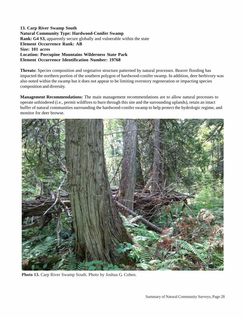
Photo 13. Carp River Swamp South. Photo by Joshua G. Cohen.
13. Carp River Swamp SouthNatural Community Type: Hardwood-Conifer SwampRank: G4 S3, apparently secure globally and vulnerable within the stateElement Occurrence Rank: ABSize: 101 acresLocation: Porcupine Mountains Wilderness State ParkElement Occurrence Identification Number: 19768
Threats: Species composition and vegetative structure patterned by natural processes. Beaver flooding hasimpacted the northern portion of the southern polygon of hardwood-conifer swamp. In addition, deer herbivory wasalso noted within the swamp but it does not appear to be limiting overstory regeneration or impacting speciescomposition and diversity.
Management Recommendations: The main management recommendations are to allow natural processes tooperate unhindered (i.e., permit wildfires to burn through this site and the surrounding uplands), retain an intactbuffer of natural communities surrounding the hardwood-conifer swamp to help protect the hydrologic regime, andmonitor for deer browse.

Summary of Natural Community Surveys, Page 29
Photo 14. Craig Lake Swamp. Photo by Joshua G. Cohen.
14. Craig Lake SwampNatural Community Type: Hardwood-Conifer SwampRank: G4 S3, apparently secure globally and vulnerable within the stateElement Occurrence Rank: BSize: 128 acresLocation: Craig Lake State ParkElement Occurrence Identification Number: 19761
Threats: Species composition and structure driven by natural processes and past anthropogenic disturbance. Cutstumps occur scattered throughout the swamp and hiking trails occur adjacent to several of the hardwood-coniferswamp polygons.
Management Recommendations: The main management recommendations are to allow natural processes tooperate unhindered (i.e., permit wildfires to burn through this site and the surrounding uplands) and to retain anintact buffer of natural communities surrounding the wetland to help protect the hydrologic regime.

Summary of Natural Community Surveys, Page 30
Photo 15. Little Carp River Swamp. Photo by Joshua G. Cohen.
15. Little Carp River SwampNatural Community Type: Hardwood-Conifer SwampRank: G4 S3, apparently secure globally and vulnerable within the stateElement Occurrence Rank: BSize: 14 acresLocation: Porcupine Mountains Wilderness State ParkElement Occurrence Identification Number: 19769
Threats: Species composition and vegetative structure patterned by natural processes. Deer herbivory was notedwithin the swamp but it does not appear to be limiting tree regeneration or impacting species composition anddiversity.
Management Recommendations: The main management recommendations are to allow natural processes tooperate unhindered (i.e., permit wildfires to burn through this site and the surrounding uplands), retain an intactbuffer of natural communities surrounding the hardwood-conifer swamp to help protect the hydrologic regime, andmonitor for deer browse.

Summary of Natural Community Surveys, Page 31
Photo 16. Mirror Lake Swamp. Photo by Joshua G. Cohen.
16. Mirror Lake SwampNatural Community Type: Hardwood-Conifer SwampRank: G4 S3, apparently secure globally and vulnerable within the stateElement Occurrence Rank: ABSize: 46 acresLocation: Porcupine Mountains Wilderness State ParkElement Occurrence Identification Number: 19767
Threats: Species composition and vegetative structure patterned by natural processes. No threats noted duringsurvey
Management Recommendations: The main management recommendations are to allow natural processes tooperate unhindered (i.e., permit wildfires to burn through this site and the surrounding uplands), retain an intactbuffer of natural communities surrounding the hardwood-conifer swamp to help protect the hydrologic regime, andmonitor for deer browse.

Summary of Natural Community Surveys, Page 32
Photo 17. Union Creek Swamp. Photo by Joshua G. Cohen.
17. Union Creek SwampNatural Community Type: Hardwood-Conifer SwampRank: G4 S3, apparently secure globally and vulnerable within the stateElement Occurrence Rank: BSize: 42 acresLocation: Porcupine Mountains Wilderness State ParkElement Occurrence Identification Number: 19770
Threats: Species composition and vegetative structure patterned by natural processes. Deer herbivory was notedwithin the swamp but it does not appear to be limiting tree regeneration or impacting species composition anddiversity.
Management Recommendations: The main management recommendations are to allow natural processes tooperate unhindered (i.e., permit wildfires to burn through this site and the surrounding uplands), retain an intactbuffer of natural communities surrounding the hardwood-conifer swamp to help protect the hydrologic regime, andmonitor for deer browse.

Summary of Natural Community Surveys, Page 33
HILLSIDE PRAIRIE
Overview: Hillside prairie is a grassland or savanna community that occurs on moderate to steep exposed slopesand crests of hills associated with river valleys, streams, or kettle lakes, surrounded by oak forest or oak savanna.This natural community is almost always found on south- to west-facing slopes, where exposure to sunlight ishighest. Soils are typically strongly acid to neutral loamy sand or sandy loam, and often mixed with gravel. Hillsideprairie is notable for supporting several state-listed plant species largely restricted to this community type (Kost etal. 2007).
Figure 10. Distribution of hillside prairie in Michigan.

Summary of Natural Community Surveys, Page 34
Photo 18. Menominee River Prairie. Photo by Joshua G. Cohen.
18. Menominee River PrairieNatural Community Type: Hillside PrairieRank: G3 S1, globally vulnerable and critically imperiled within the stateElement Occurrence Rank: CSize: 1.4 acresLocation: Menominee River State Recreation AreaElement Occurrence Identification Number: 19737
Threats: Numerous non-native species were noted within the hillside prairie including timothy (Phleum pratense),spotted knapweed (Centaurea stoebe), Kentucky bluegrass (Poa pratensis), and smooth brome (Bromusinermis). Fire suppression has led to the encroachment of woody species including basswood (Tilia americana)and red maple (Acer rubrum). Large numbers of deer utilize this river corridor and deer browse of understory andground cover species is likely prevalent in the hillside prairie.
Management Recommendations: The main management recommendations are to allow natural processes tooperate unhindered (i.e., let wildfires burn), control non-native species and monitor control efforts, reduce deerdensities and deer browse pressure, maintain a natural community buffer surrounding the hillside prairie to preventthe increase of a weedy seed source, and periodically employ prescribed fire to maintain the open physiognomy,reintroduce this important natural disturbance factor, and control non-native species. The sand and loamy sandsubstrate on the steep slopes is prone to erosion, so care must be taken to prevent excessive foot traffic and soildisturbance.

Summary of Natural Community Surveys, Page 35
INTERDUNAL WETLAND
Overview: Interdunal wetland is a rush-, sedge-, and shrub-dominated wetland situated in depressions within opendunes or between beach ridges along the Great Lakes, experiencing a fluctuating water table seasonally and yearlyin synchrony with lake level changes (Kost et al. 2007).
Figure 11. Distribution of interdunal wetland in Michigan.

Summary of Natural Community Surveys, Page 36
19. Besser Natural AreaNatural Community Type: Interdunal WetlandRank: G2? S2, imperiled throughout rangeElement Occurrence Rank: BCSize: 7 acresLocation: Rockport State ParkElement Occurrence Identification Number: 18757
Threats: Threats include illegal off-road vehicle activity and invasive plants. Spotted knapweed (Centaureastoebe) was documented in the adjacent open dunes and off-road vehicle tracks were noted within portions of theinterdunal wetland.
Management Recommendations: The primary management recommendations are to allow natural processes tooperate unhindered, eliminate illegal off-road vehicle activity, and control and monitor non-native plants along theshoreline (i.e., spotted knapweed).
Photo 19. Besser Natural Area interdunal wetland. Photo by Joshua G. Cohen.

Summary of Natural Community Surveys, Page 37
20. Rockport SouthNatural Community Type: Interdunal WetlandRank: G2? S2, imperiled throughout rangeElement Occurrence Rank: BCSize: 1.1 acresLocation: Rockport State ParkElement Occurrence Identification Number: 19744
Threats: Species composition and structure of the interdunal wetland are driven by natural processes. Threatsinclude illegal off-road vehicle activity and invasive plants. Non-natives occur scattered along the adjacentlimestone cobble shore and include reed canary grass (Phalaris arundinacea), spotted knapweed (Centaureastoebe), purple loosestrife (Lythrum salicaria), white sweet-clover (Melilotus alba), ox-eye daisy(Chrysanthemum leucanthemum), and reed (Phragmites australis). Purple loosestrife was documented locally ininterdunal wetland and off-road vehicle tracks were noted along the nearby storm beach.
Management Recommendations: The primary management recommendations are to allow natural processes tooperate unhindered, eliminate illegal off-road vehicle activity, and control and monitor non-native plants along theshoreline.
Photo 20. Rockport South interdunal wetland. Photo by Joshua G. Cohen.

Summary of Natural Community Surveys, Page 38
LIMESTONE COBBLE SHORE
Overview: Limestone cobble shore occurs along gently sloping shorelines of Lake Michigan and Lake Huron. Thecommunity is studded with cobbles and boulders and is frequently inundated by storms and periods of high water.Limestone cobble shore is typically sparsely vegetated, because cobbles cover most of the surface and stormwaves prevent the development of a diverse, persistent plant community. Soils are neutral to slightly alkaline mucksand sands that accumulate between cobbles and boulders (Kost et al. 2007).
Figure 12. Distribution of limestone cobble shore in Michigan.

Summary of Natural Community Surveys, Page 39
Photo 21. Besser Natural Area limestone cobble shore. Photo by Joshua G. Cohen.
21. Besser Natural AreaNatural Community Type: Limestone Cobble ShoreRank: G2G3 S3, imperiled to vulnerable globally and vulnerable within the stateElement Occurrence Rank: BSize: 54 acresLocation: Rockport State ParkElement Occurrence Identification Number: 18759
Threats: The species composition and zonation of the limestone cobble shore are patterned by natural processes.Threats include off-road vehicle activity and invasive plants. Non-natives occur scattered along the shoreline andinclude spotted knapweed (Centaurea stoebe), white sweet-clover (Melilotus alba), and reed (Phragmitesaustralis). A large clump of non-native reed occurs just north of Ferrion Point. Off-road vehicle activity was notedalong the shoreline in areas of adjacent interdunal wetland.
Management Recommendations: The main management recommendations are to allow natural processes tooperate unhindered, control populations of non-native species, and maintain a natural community buffer surroundingthe shoreline to prevent the increase of the weedy seed source, and monitor for invasive plant populations.

Summary of Natural Community Surveys, Page 40
22. Lime IslandNatural Community Type: Limestone Cobble ShoreRank: G2G3 S3, imperiled to vulnerable globally and vulnerable within the stateElement Occurrence Rank: BSize: 22 acresLocation: Lime Island State Recreation AreaElement Occurrence Identification Number: 19748
Threats: Lime Island was formerly used as a fueling station for oil tankers travelling through the Saint MarysRiver. Many of these tankers dumped coal along the shore, especially south of the dock along limestone cobbleshore. Non-natives are locally common along the limestone cobble shore, especially south of the dock on the westside of island and include reed canary grass (Phalaris arundinacea), St. John’s-wort (Hypericum perforatum),spotted knapweed (Centaurea stoebe), wild parsnip (Pastinaca sativa), purple loosestrife (Lythrum salicaria),common mullein (Verbascum thapsus), white sweet-clover (Melilotus alba), ox-eye daisy (Chrysanthemumleucanthemum), and Kentucky bluegrass (Poa pratensis). In addition, deer browse is prevalent along the shoreand off-road vehicle damage was noted along the western side of the island especially in Great Lakes marsh.Anthropogenic debris (e.g., coal, dock material, metal, and trash) occurs scattered along the shore of the island.
Management Recommendations: The primary management recommendations are to allow natural processes tooperate unhindered, eliminate off-road vehicle activity along the shoreline, control non-native plants along theshoreline, and maintain a natural community buffer surrounding the shoreline to prevent the increase of the weedyseed source. Monitoring should be implemented for non-native plant populations and deer herbivory. In addition,anthropogenic debris along the shoreline could be cleaned up.
Photo 22. Lime Island limestone cobble shore. Photo by Joshua G. Cohen.

Summary of Natural Community Surveys, Page 41
23. Rockport SouthNatural Community Type: Limestone Cobble ShoreRank: G2G3 S3, imperiled to vulnerable globally and vulnerable within the stateElement Occurrence Rank: BCSize: 18 acresLocation: Rockport State ParkElement Occurrence Identification Number: 19745
Threats: Species composition and structure of the interdunal wetland are driven by natural processes. Threatsinclude illegal off-road vehicle activity and invasive plants. Non-natives occur scattered along the limestone cobbleshore and include reed canary grass (Phalaris arundinacea), spotted knapweed (Centaurea stoebe), purpleloosestrife (Lythrum salicaria), white sweet-clover (Melilotus alba), ox-eye daisy (Chrysanthemumleucanthemum), and reed (Phragmites australis). Off-road vehicle tracks were noted along the upper margin ofthe limestone cobble shore.
Management Recommendations: The main management recommendations are to allow natural processes tooperate unhindered, control populations of non-native species, eliminate illegal off-road vehicle activity, maintain anatural community buffer surrounding the shoreline to prevent the increase of the weedy seed source, and monitorfor invasive plant populations.
Photo 23. Rockport South limestone cobble shore. Photo by Joshua G. Cohen.

Summary of Natural Community Surveys, Page 42
MUSKEG
Overview: Muskeg is a nutrient-poor peatland characterized by acidic, saturated peat, and scattered or clumped,stunted conifer trees set in a matrix of sphagnum mosses and ericaceous shrubs. Black spruce (Picea mariana)and tamarack (Larix laricina) are typically the most prevalent tree species. The community primarily occurs inlarge depressions on glacial outwash and sandy glacial lakeplains. Fire occurs naturally during periods of droughtand can alter the hydrology, mat surface, and floristic composition of muskegs. Windthrow, beaver flooding, andinsect defoliation are also important disturbance factors that influence species composition and structure (Kost etal. 2007).
Figure 13. Distribution of muskeg in Michigan.
Summary of Natural Community Surveys, Page 43
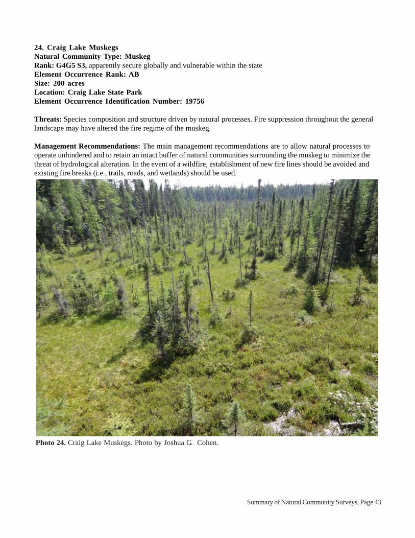
Photo 24. Craig Lake Muskegs. Photo by Joshua G. Cohen.
24. Craig Lake MuskegsNatural Community Type: MuskegRank: G4G5 S3, apparently secure globally and vulnerable within the stateElement Occurrence Rank: ABSize: 200 acresLocation: Craig Lake State ParkElement Occurrence Identification Number: 19756
Threats: Species composition and structure driven by natural processes. Fire suppression throughout the generallandscape may have altered the fire regime of the muskeg.
Management Recommendations: The main management recommendations are to allow natural processes tooperate unhindered and to retain an intact buffer of natural communities surrounding the muskeg to minimize thethreat of hydrological alteration. In the event of a wildfire, establishment of new fire lines should be avoided andexisting fire breaks (i.e., trails, roads, and wetlands) should be used.

Summary of Natural Community Surveys, Page 44
NORTHERN FEN
Overview: Northern fen is a sedge- and rush-dominated wetland occurring on neutral to moderately alkalinesaturated peat and/or marl influenced by groundwater rich in calcium and magnesium carbonates. The communityoccurs north of the climatic tension zone and is found primarily where calcareous bedrock underlies a thin mantle ofglacial drift on flat areas or shallow depressions of glacial outwash and glacial lakeplains and also in kettledepressions on pitted outwash and moraines (Kost et al. 2007).
Figure 14. Distribution of northern fen in Michigan.

Summary of Natural Community Surveys, Page 45
25. Ferrion Point FenNatural Community Type: Northern FenRank: G3G5 S3, vulnerable to secure globally and vulnerable within the stateElement Occurrence Rank: BCSize: 4 acresLocation: Rockport State ParkElement Occurrence Identification Number: 19746
Threats: An old corduroy road passes through northern fen. No non-native species were found during the survey.Threats to the fen include illegal off-road vehicle activity and invasive plants. Spotted knapweed (Centaureastoebe) was documented in the adjacent open dunes and off-road vehicle tracks were noted within the nearbyinterdunal wetland.
Management Recommendations: The main management recommendations are to maintain a natural communitybuffer adjacent to the fen to minimize disturbance to the wetland hydrology and the threat of invasion by non-nativespecies.
Photo 25. Ferrion Point Fen. Photo by Joshua G. Cohen.

Summary of Natural Community Surveys, Page 46
Photo 26. Keweenaw Point northern fen. Photo by Joshua G. Cohen.
26. Keweenaw PointNatural Community Type: Northern FenRank: G3G5 S3, vulnerable to secure globally and vulnerable within the stateElement Occurrence Rank: ABSize:66 acresLocation: Baraga State Forest Management UnitElement Occurrence Identification Number: 17279
Threats: The species composition and structure of this northern fen is influenced by natural processes. Noanthropogenic disturbances or non-native species noted during course of survey. Logging in the surroundingswamp and boreal forest could alter the local hydrology of the peatland.
Management Recommendations: The main management recommendations are to allow natural processes (i.e.,windthrow, flooding, and fire) to operate unhindered, maintain canopy closure of the surrounding swamp to minimizehydrologic disturbance to the fen and maintain groundwater seepage and monitor for invasive plant population andillegal off-road vehicle use.

Summary of Natural Community Surveys, Page 47
Photo 27. Middle Lake Fen. Photo by Joshua G. Cohen.
27. Middle Lake FenNatural Community Type: Northern FenRank: G3G5 S3, vulnerable to secure globally and vulnerable within the stateElement Occurrence Rank: BSize: 11 acresLocation: Rockport State ParkElement Occurrence Identification Number: 19742
Threats: The species composition and structure of this northern fen is primarily influenced by natural processesbut also impacted by invasive species and deer herbivory. Non-native species occur scattered in the fen, especiallyin drier areas, and include glossy buckthorn (Frangula alnus), timothy (Phleum pratense), and narrow-leaved cat-tail (Typha angustifolia). Deer trails occur throughout the fen and deer browse is influencing species compositionand vegetative structure. In addition, off-road vehicle activity was noted locally.
Management Recommendations: The main management recommendations are to allow natural processes tooperate unhindered, retain an intact buffer of natural communities surrounding the wetland to minimize the threat ofhydrological alteration, control and monitor invasive species (especially glossy buckthorn), reduce deer densities inthe surrounding landscape to dampen deer browse pressure, and eliminate illegal off-road vehicle activity.

Summary of Natural Community Surveys, Page 48
NORTHERN HARDWOOD SWAMP
Overview: Northern hardwood swamp is a seasonally inundated, deciduous swamp forest community dominatedby black ash (Fraxinus nigra) that occurs on neutral to slightly acidic, hydric mineral soils and shallow muck overmineral soils. Located north of the climatic tension zone, northern hardwood swamp is found primarily indepressions on level to hummocky glacial lakeplains, fine- and medium-textured glacial tills, and broad flat outwashplains. Fundamental disturbance factors affecting northern hardwood swamp development include seasonal floodingand windthrow (Kost et al. 2007).
Figure 15. Distribution of northern hardwood swamp in Michigan.

Summary of Natural Community Surveys, Page 49
28. Government Peak SwampNatural Community Type: Northern Hardwood SwampRank: G4 S3, apparently secure globally and vulnerable within the stateElement Occurrence Rank: ABSize: 14 acresLocation: Porcupine Mountains Wilderness State ParkElement Occurrence Identification Number: 19771
Threats: No anthropogenic disturbances or non-native plants were noted during the course of the survey. Speciescomposition and vegetative structure patterned by natural processes.
Management Recommendations: The main management recommendations are to allow natural processes tooperate unhindered (i.e., permit wildfires to burn through this site and the surrounding uplands) and to retain anintact buffer of natural communities surrounding the northern hardwood swamp to help protect the hydrologicregime.
Photo 28. Government Peak Swamp. Photo by Joshua G. Cohen.

Summary of Natural Community Surveys, Page 50
29. Lake of the Clouds SwampNatural Community Type: Northern Hardwood SwampRank: G4 S3, apparently secure globally and vulnerable within the stateElement Occurrence Rank: ABSize: 4 acresLocation: Porcupine Mountains Wilderness State ParkElement Occurrence Identification Number: 19772
Threats: No anthropogenic disturbances or non-native plants were noted during the course of the survey. Speciescomposition and vegetative structure patterned by natural processes. Deer herbivory was noted within the swampbut it does not appear to be limiting tree regeneration or impacting species composition and diversity.
Management Recommendations: The main management recommendations are to allow natural processes tooperate unhindered (i.e., permit wildfires to burn through this site and the surrounding uplands) and to retain anintact buffer of natural communities surrounding the northern hardwood swamp to help protect the hydrologicregime. The swamp should be monitored to gauge whether deer herbivory is impacting species composition andvegetative structure.
Photo 29. Lake of the Clouds Swamp. Photo by Joshua G. Cohen.

Summary of Natural Community Surveys, Page 51
30. Rockport SwampNatural Community Type: Northern Hardwood SwampRank: G4 S3, apparently secure globally and vulnerable within the stateElement Occurrence Rank: BCSize: 4 acresLocation: Rockport State ParkElement Occurrence Identification Number: 19747
Threats: No anthropogenic disturbances or non-native plants were noted during the course of the survey. Speciescomposition and vegetative structure patterned by natural processes. Deer browse is likely influencing the floristiccomposition and structure. Cut stumps occur in portions of the swamp.
Management Recommendations: The main management recommendations are to allow natural processes (i.e.,windthrow, flooding, and fire) to operate unhindered, maintain canopy closure of the surrounding uplands tominimize surface water flow into the swamp and to maintain groundwater seepage, reduce deer densities in thesurrounding landscape to dampen deer browse pressure, and monitor for invasive plant populations.
Photo 30. Rockport Swamp. Photo by Joshua G. Cohen.
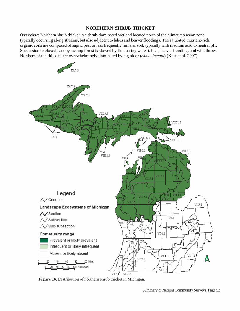
Summary of Natural Community Surveys, Page 52
NORTHERN SHRUB THICKET
Overview: Northern shrub thicket is a shrub-dominated wetland located north of the climatic tension zone,typically occurring along streams, but also adjacent to lakes and beaver floodings. The saturated, nutrient-rich,organic soils are composed of sapric peat or less frequently mineral soil, typically with medium acid to neutral pH.Succession to closed-canopy swamp forest is slowed by fluctuating water tables, beaver flooding, and windthrow.Northern shrub thickets are overwhelmingly dominated by tag alder (Alnus incana) (Kost et al. 2007).
Figure 16. Distribution of northern shrub thicket in Michigan.

Summary of Natural Community Surveys, Page 53
Photo 31. Pesheke River Thicket. Photo by Joshua G. Cohen.
31. Pesheke River ThicketNatural Community Type: Northern Shrub ThicketRank: G4 S5, apparently secure globally and secure within the stateElement Occurrence Rank: ABSize: 86 acresLocation: Craig Lake State ParkElement Occurrence Identification Number: 19764
Threats: No anthropogenic disturbances or non-native plants were noted during the course of the survey. A footbridge crosses the northern shrub thicket in one location.
Management Recommendations: The main management recommendations are to allow natural processes (i.e.,beaver flooding and wildfire) to operate unhindered and to retain an intact buffer of natural communitiessurrounding the wetland to protect the hydrologic regime. In the event of a wildfire, establishment of new fire linesshould be avoided and existing fire breaks (i.e., trails, roads, and wetlands) should be used.

Summary of Natural Community Surveys, Page 54
NORTHERN WET MEADOW
Overview: Northern wet meadow is an open, groundwater-influenced, sedge- and grass-dominated wetland thatoccurs in the northern Lower and Upper Peninsulas and typically borders streams but is also found on pond andlake margins and above beaver dams. Soils are nearly always sapric peat and range from strongly acid to neutral inpH. Open conditions are maintained by seasonal flooding, beaver-induced flooding, and fire (Kost et al. 2007).
Figure 17. Distribution of northern wet meadow in Michigan.

Summary of Natural Community Surveys, Page 55
Photo 32. Little Carp River Meadow. Photo by Joshua G. Cohen.
32. Little Carp River MeadowNatural Community Type: Northern Wet MeadowRank: G4G5 S3, apparently secure globally and vulnerable within the stateElement Occurrence Rank: ABSize: 48 acresLocation: Porcupine Mountains Wilderness State ParkElement Occurrence Identification Number: 19774
Threats: No anthropogenic disturbances or non-native plants were noted during the course of the survey. Thespecies composition and structure of the northern wet meadow is driven by natural processes.
Management Recommendations: The main management recommendations are to allow natural processes tooperate unhindered and to retain an intact buffer of natural communities surrounding the wetland to minimize thethreat of hydrological alteration. In the event of a wildfire, establishment of new fire lines should be avoided andexisting fire breaks (i.e., trails and wetlands) should be used.

Summary of Natural Community Surveys, Page 56
33. Pesheke River MeadowNatural Community Type: Northern Shrub ThicketRank: G4 S5, apparently secure globally and secure within the stateElement Occurrence Rank: BSize: 30 acresLocation: Craig Lake State ParkElement Occurrence Identification Number: 19765
Threats: No anthropogenic disturbances or non-native plants were noted during the course of the survey. Thespecies composition and structure of the northern wet meadow is driven by natural processes.
Management Recommendations: The main management recommendations are to allow natural processes tooperate unhindered and to retain an intact buffer of natural communities surrounding the wetland to minimize thethreat of hydrological alteration. In the event of a wildfire, establishment of new fire lines should be avoided andexisting fire breaks (i.e., trails and wetlands) should be used.
Photo 33. Pesheke River Meadow. Photo by Joshua G. Cohen.

Summary of Natural Community Surveys, Page 57
OAK-PINE BARRENS
Overview: Oak-pine barrens is a fire-dependent, savanna community dominated by oaks and pines, havingbetween 5 and 60% canopy cover, with or without a shrub layer. The predominantly graminoid ground layercontains plant species associated with both prairie and forest. The community occurs on a variety of landforms ondroughty, infertile sand or loamy sands occasionally within southern Lower Michigan but mostly north of theclimatic tension zone in the northern Lower and Upper Peninsulas (Kost et al. 2007).
Figure 18. Distribution of oak-pine barrens in Michigan.

Summary of Natural Community Surveys, Page 58
Photo 34. Menominee River Barrens. Photo by Joshua G. Cohen.
34. Menominee River BarrensNatural Community Type: Oak-Pine BarrensRank: G3 S2, globally vulnerable and imperiled within the stateElement Occurrence Rank: CDSize: 15 acresLocation: Menominee River State Recreation AreaElement Occurrence Identification Number: 19740
Threats: Overall this oak-pine barrens is very weedy and has been negatively impacted by fire suppression.Numerous non-native species were noted within the barrens including spotted knapweed (Centaurea stoebe),Kentucky bluegrass (Poa pratensis), smooth brome (Bromus inermis), St. John’s-wort (Hypericum perforatum),and common mullein (Verbascum thapsus). Large numbers of deer utilize the Menominee River corridor duringwinter months and deer browse of understory and ground cover species is likely prevalent in the barrens. Firesuppression has led to the encroachment into the overstory and understory of the oak-pine barrens of mesophyticspecies, (e.g., cherry species).
Management Recommendations: The main management recommendations are to allow natural processes tooperate unhindered (i.e., let wildfires burn), control non-native species and monitor control efforts, reduce deerdensities and deer browse pressure, maintain a natural community buffer surrounding the barrens to prevent theincrease of a weedy seed source, and periodically employ prescribed fire to maintain the open physiognomy,reintroduce this important natural disturbance factor, and help control non-native species.

Summary of Natural Community Surveys, Page 59
OPEN DUNES
Overview: Open dunes is a grass- and shrub-dominated multi-seral community located on wind-deposited sandformations near the shorelines of the Great Lakes. Dune formation and the patterning of vegetation are stronglyaffected by lake-driven winds. The greatest concentration of open dunes occurs along the eastern and northernshorelines of Lake Michigan, with the largest dunes occurring along the eastern shoreline due to the prevailingsouthwest winds (Kost et al. 2007).
Figure 19. Distribution of open dunes in Michigan.

Summary of Natural Community Surveys, Page 60
Photo 35. Besser Natural Area open dunes. Photo by Joshua G. Cohen.
35. Besser Natural AreaNatural Community Type: Open DunesRank: G3 S3, vulnerable throughout rangeElement Occurrence Rank: BCSize: 10 acresLocation: Rockport State ParkElement Occurrence Identification Number: 18758
Threats: Threats include illegal off-road vehicle activity, erosion from foot traffic, and invasive plants. Spottedknapweed (Centaurea stoebe) was documented within the open dunes and off-road vehicle activity was notedalong nearshore areas and in the adjacent interdunal wetlands.
Management Recommendations: The primary management recommendations are to allow natural processes tooperate unhindered, control clusters of non-native plants (i.e., spotted knapweed), eliminate off-road vehicle activity,and increase educational efforts to encourage visitors to stay on trails. Monitoring for invasive species should beimplemented following control efforts.

Summary of Natural Community Surveys, Page 61
POOR CONIFER SWAMP
Overview: Poor conifer swamp is a nutrient-poor, forested peatland characterized by acidic, saturated peat, andthe prevalence of conifer trees, Sphagnum mosses, and ericaceous shrubs. The community is located indepressions in glacial outwash and sandy glacial lakeplains and in kettles on pitted outwash and depressions onmoraines. Poor conifer swamp occasionally occurs on floating mats on the margins of lakes and ponds. Fire occursnaturally during drought periods and creates even-aged, often monospecific, stands of Picea mariana (blackspruce). Windthrow, beaver flooding, and insect defoliation are also important disturbance factors influencingspecies composition and structure (Kost et al. 2007).
Figure 20. Distribution of poor conifer swamp in Michigan.

Summary of Natural Community Surveys, Page 62
Photo 36. Craig Lake Spruce Swamp. Photo by Joshua G. Cohen.
36. Craig Lake Spruce SwampNatural Community Type: Poor Conifer SwampRank: G4 S4, apparently secure globally and within the stateElement Occurrence Rank: BSize: 118 acresLocation: Craig Lake State ParkElement Occurrence Identification Number: 19762
Threats: The species composition and vegetative structure of the poor conifer swamp are influenced by naturalprocesses. Fire suppression throughout the general landscape may have altered the fire regime of the poor coniferswamp.
Management Recommendations: The main management recommendations are to allow natural processes tooperate unhindered and to retain an intact buffer of natural communities surrounding the wetland to minimize thethreat of hydrological alteration. In the event of a wildfire, establishment of new fire lines should be avoided andexisting fire breaks (i.e., trails, roads, and wetlands) should be used.
Summary of Natural Community Surveys, Page 63
POOR FEN
Overview: Poor fen is a sedge-dominated wetland found on very strongly to strongly acid, saturated peat that ismoderately influenced by groundwater. The community occurs primarily north of the climatic tension zone in kettledepressions and in flat areas or mild depressions on glacial outwash and glacial lakeplain (Kost et al. 2007).
Figure 21. Distribution of poor fen in Michigan.

Summary of Natural Community Surveys, Page 64
Photo 37. Craig Lake Fens. Photo by Joshua G. Cohen.
37. Craig Lake FensNatural Community Type: Poor FenRank: G3G5 S3, vulnerable to secure globally and vulnerable within the stateElement Occurrence Rank: BSize: 55 acresLocation: Craig Lake State ParkElement Occurrence Identification Number: 19759
Threats: The species composition and vegetative structure of the poor fen are influenced by natural processes.Fire suppression throughout the general landscape may have altered the fire regime of the poor fen.
Management Recommendations: The main management recommendations are to allow natural processes tooperate unhindered and to retain an intact buffer of natural communities surrounding the wetland to minimize thethreat of hydrological alteration. In the event of a wildfire, establishment of new fire lines should be avoided andexisting fire breaks (i.e., trails, roads, and wetlands) should be used.

Summary of Natural Community Surveys, Page 65
RICH CONIFER SWAMP
Overview: Rich conifer swamp is a groundwater-influenced, minerotrophic, forested wetland dominated bynorthern white-cedar (Thuja occidentalis) that occurs on organic soils (i.e., peat) primarily north of the climatictension zone in the northern Lower and Upper Peninsulas. Rich conifer swamp occurs in outwash channels,outwash plains, glacial lakeplains, and in depressions on coarse- to medium-textured ground moraines. It is commonin outwash channels of drumlin fields and where groundwater seeps occur at the bases of moraines. Rich coniferswamp typically occurs in association with lakes and cold, groundwater-fed streams. It also occurs along the GreatLakes shoreline in old abandoned embayments and in swales between former beach ridges where it may be part ofa wooded dune and swale complex. Windthrow is common, especially on broad, poorly drained sites. Fire washistorically infrequent. Rich conifer swamp is characterized by diverse microtopography and ground cover. Thecommunity is also referred to as cedar swamp (Kost et al. 2007).
Figure 22. Distribution of rich conifer swamp in Michigan.

Summary of Natural Community Surveys, Page 66
Photo 38. Hoar Creek Swamp. Photo by Joshua G. Cohen.
38. Hoar Creek SwampNatural Community Type: Rich Conifer SwampRank: G4 S3, apparently secure globally and vulnerable within the stateElement Occurrence Rank: ABSize: 147 acresLocation: Baraga State Forest Management UnitElement Occurrence Identification Number: 19751
Threats: No anthropogenic disturbances or non-native plants were noted during the course of the survey. Thespecies compositon and structure of this rich conifer swamp is influenced by natural processes.
Management Recommendations: The main management recommendations are to allow natural processes (i.e.,beaver flooding, wildfire, and windthrow) to operate unhindered, retain an intact buffer of natural communitiessurrounding the wetland to protect the hydrologic regime, and monitor for invasive species and illegal off-roadvehicle use.

Summary of Natural Community Surveys, Page 67
Photo 39. Menominee River Swamp. Photo by Joshua G. Cohen.
39. Menominee River SwampNatural Community Type: Rich Conifer SwampRank: G4 S3, apparently secure globally and vulnerable within the stateElement Occurrence Rank: CSize: 18 acresLocation: Menominee River State Recreation AreaElement Occurrence Identification Number: 19735
Threats: Deer browse pressure is high and has impacted the species composition and vegetative structure of therich conifer swamp. In addition, cut stumps were noted throughout the swamp.
Management Recommendations: The main management recommendations are to allow natural processes tooperate unhindered, retain an intact buffer of natural communities surrounding the wetland to minimize the threat ofhydrological alteration, reduce local deer populations, and monitor deer browse pressure.
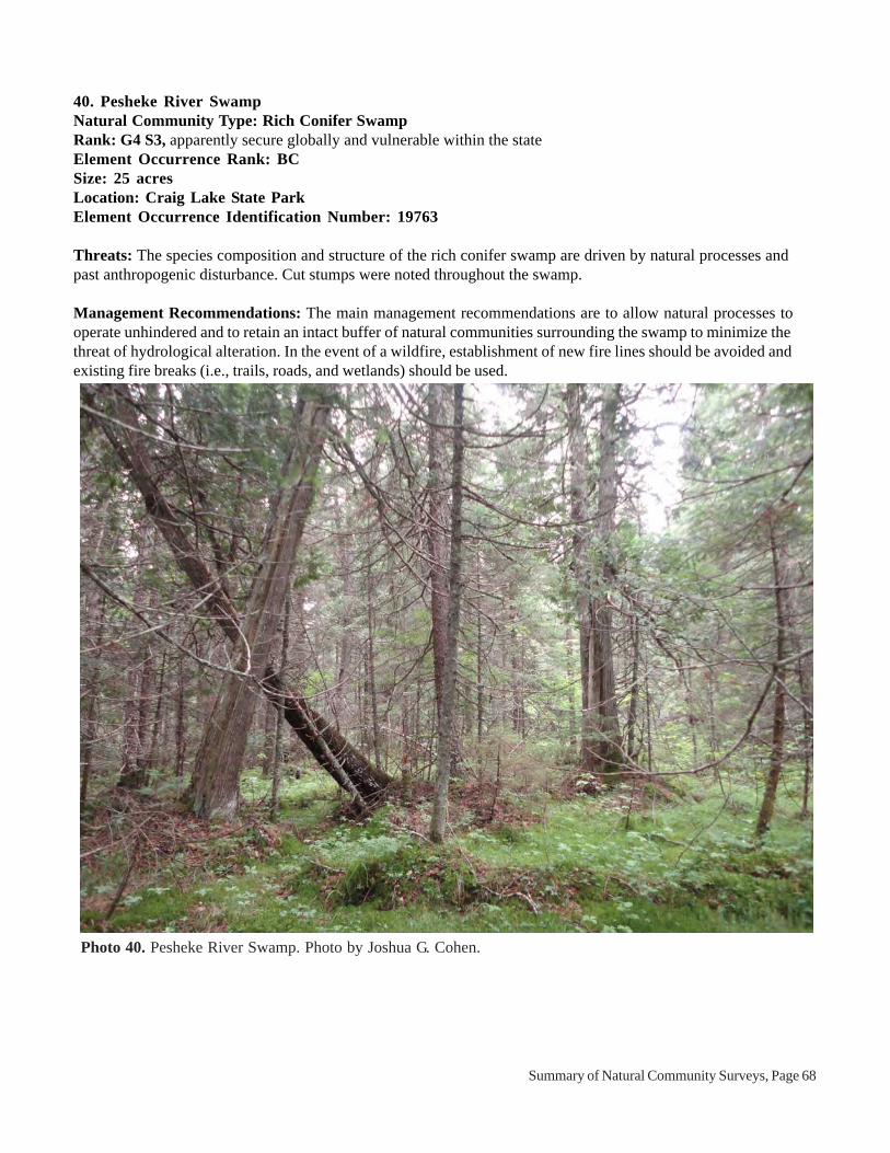
Summary of Natural Community Surveys, Page 68
Photo 40. Pesheke River Swamp. Photo by Joshua G. Cohen.
40. Pesheke River SwampNatural Community Type: Rich Conifer SwampRank: G4 S3, apparently secure globally and vulnerable within the stateElement Occurrence Rank: BCSize: 25 acresLocation: Craig Lake State ParkElement Occurrence Identification Number: 19763
Threats: The species composition and structure of the rich conifer swamp are driven by natural processes andpast anthropogenic disturbance. Cut stumps were noted throughout the swamp.
Management Recommendations: The main management recommendations are to allow natural processes tooperate unhindered and to retain an intact buffer of natural communities surrounding the swamp to minimize thethreat of hydrological alteration. In the event of a wildfire, establishment of new fire lines should be avoided andexisting fire breaks (i.e., trails, roads, and wetlands) should be used.

Summary of Natural Community Surveys, Page 69
SUBMERGENT MARSH
Figure 23. Distribution of submergent marsh in Michigan.
Overview: Submergent marsh is an herbaceous plant community that occurs in deep to sometimes shallow waterin lakes and streams throughout Michigan. Soils are characterized by loosely consolidated organics of variabledepth that range from acid to alkaline and accumulate over all types of mineral soil, even bedrock. Submergentvegetation is composed of both rooted and non-rooted submergent plants, rooted floating-leaved plants, and non-rooted floating plants. Common submergent plants include common waterweed (Elodea canadensis), water star-grass (Heteranthera dubia), milfoils (Myriophyllum spp.), naiads (Najas spp.), pondweeds (Potamogeton spp.),stoneworts (Chara spp. and Nitella spp.), coontail (Ceratophyllum demersum), bladderworts (Utricularia spp.),and water-celery (Vallisneria americana) (Kost et al. 2007).

Summary of Natural Community Surveys, Page 70
Photo 41. Keweenaw Point submergent marsh. Photo by Joshua G. Cohen.
41. Keweenaw PointNatural Community Type: Submergent MarshRank: GU S4, globally unrankable and secure within the stateElement Occurrence Rank: ABSize: 13 acresLocation: Baraga State Forest Management UnitElement Occurrence Identification Number: 19753
Threats: The species composition and structure of this submergent marsh are influenced by natural processes. Noanthropogenic disturbances or non-native species were noted during the course of survey. Logging in thesurrounding swamp and boreal forest could alter the local hydrology of the wetland.
Management Recommendations: The main management recommendations are to allow natural processes tooperate unhindered, retain an intact buffer of natural communities surrounding the wetland to minimize the threat ofhydrological alteration, and monitor for invasive plants and illegal off-road vehicle use.

Summary of Natural Community Surveys, Page 71
42. Mirror Lake TrailNatural Community Type: Submergent MarshRank: GU S4, globally unrankable and secure within the stateElement Occurrence Rank: ABSize: 11 acresLocation: Porcupine Mountains Wilderness State ParkElement Occurrence Identification Number: 19775
Threats: The species composition and structure of this submergent marsh are influenced by natural processes. Noanthropogenic disturbances or non-native species were noted during the course of survey.
Management Recommendations: The main management recommendations are to allow natural processes tooperate unhindered and to retain an intact buffer of natural communities surrounding the wetland to minimize thethreat of hydrological alteration.
Photo 42. Mirror Lake Trail submergent marsh. Photo by Joshua G. Cohen.

Summary of Natural Community Surveys, Page 72
VOLCANIC BEDROCK GLADE
Figure 24. Distribution of volcanic bedrock glade in Michigan.
Overview: Volcanic bedrock glade consists of an open forested or savanna community found where basalticbedrock and conglomerates are exposed. The sparse vegetation consists of scattered open-grown trees, scatteredshrubs or shrub thickets, and a partial turf of herbs, grasses, sedges, mosses, and lichens. The community occurs inthe western Upper Peninsula on Isle Royale and the Keweenaw Peninsula, extending southwest into Houghton,Ontonagon, and Gogebic Counties (Kost et al. 2007).

Summary of Natural Community Surveys, Page 73
Photo 43. Brandts Creek Glade. Photo by Joshua G. Cohen.
43. Brandts Creek GladeNatural Community Type: Volcanic Bedrock GladeRank: GU S3, globally unrankable and vulnerable within the stateElement Occurrence Rank: CDSize: 5 acresLocation: Menominee River State Recreation AreaElement Occurrence Identification Number: 19739
Threats: Numerous non-native species were noted within the glade including St. John’s-wort (Hypericumperforatum), Kentucky bluegrass (Poa pratensis), and smooth brome (Bromus inermis). Large numbers of deerutilize Menominee River corridor and deer browse of understory and ground cover species is likely prevalent in thevolcanic bedrock glade. The surrounding aspen forest was clear-cut within the last ten years. This disturbancesurrounding the glades has likely increased non-native species in the glade and in the surrounding area and mayhave also increased desiccation of vegetation and soils within the glade.
Management Recommendations: The main management recommendations are to allow natural processes tooperate unhindered (i.e., let wildfires burn), control non-native plants and monitor control efforts, reduce local deerdensities, and maintain a buffer of natural communities surrounding the glade to prevent the increase of a weedyseed source.

Summary of Natural Community Surveys, Page 74
Photo 44. East Vista Glade. Photo by Joshua G. Cohen
44. East Vista GladeNatural Community Type: Volcanic Bedrock GladeRank: GU S3, globally unrankable and vulnerable within the stateElement Occurrence Rank: CSize: 3.3 acresLocation: Porcupine Mountains Wilderness State ParkElement Occurrence Identification Number: 19776
Threats: Invasive species are locally common to dominant in the glade and include timothy (Phleum pratense),spotted knapweed (Centaurea stoebe), and St. John’s-wort (Hypericum perforatum). Logging of the surroundingforests could increase the seed source for weedy species, which could be windblown or bird-dispersed onto theglades. In addition, deer browsing could impact species composition and structure.
Management Recommendations: The main management recommendations are to allow natural processes tooperate unhindered (i.e., let wildfires burn), control non-native plants, and maintain a forested buffer surroundingthe glade to prevent the increase of a weedy seed source.

Summary of Natural Community Surveys, Page 75
Photo 45. Menominee River Glade. Photo by Joshua G. Cohen
45. Menominee River GladeNatural Community Type: Volcanic Bedrock GladeRank: GU S3, globally unrankable and vulnerable within the stateElement Occurrence Rank: BCSize: 54 acresLocation: Menominee River State Recreation AreaElement Occurrence Identification Number: 19736
Threats: Species composition and structure of the volcanic bedrock glade are patterned by natural processes.Moderate to low levels of non-native species were documented during the survey. Non-native species are scatteredthroughout the glade and include include St. John’s-wort (Hypericum perforatum), spotted knapweed (Centaureastoebe), common mullein (Verbascum thapsus), and Canada bluegrass (Poa compressa). Large numbers of deerutilize the Menominee River corridor and deer browse of understory and ground cover species is likely prevalent inthe volcanic bedrock glade. Roads and trails pass by several of the volcanic bedrock glades, which receive a fairamount of foot traffic because of their proximity to the river.
Management Recommendations: The main management recommendations are to allow natural processes tooperate unhindered (i.e., let wildfires burn), control non-native species and monitor control efforts, reduce deerdensities and deer browse pressure, and maintain a natural community buffer surrounding the volcanic bedrockglade to prevent the increase of a weedy seed source.

Summary of Natural Community Surveys, Page 76
VOLCANIC CLIFF
Figure 25. Distribution of volcanic cliff in Michigan.
Overview: Volcanic cliffs consist of vertical or near-vertical exposures of bedrock, which support less than 25%vascular plant coverage, although lichens, mosses, and liverworts are abundant on some rock surfaces. The cliffscan be as high as 80 m (260 ft) and occur on inland exposures of the resistant Middle Keweenawan volcanic rock,which runs from the north tip of the Keweenaw Peninsula south into Wisconsin and also along the entire length ofIsle Royale (Kost et al. 2007).

Summary of Natural Community Surveys, Page 77
Photo 46. Porcupine South volcanic cliff. Photo by Joshua G. Cohen.
46. Porcupine SouthNatural Community Type: Volcanic CliffRank: G4G5 S2, apparently secure globally and imperiled within the stateElement Occurrence Rank: ABSize: 44 acresLocation: Porcupine Mountains Wilderness State ParkElement Occurrence Identification Number: 19773
Threats: The species composition and structure of this volcanic cliff are influenced by natural processes. Noanthropogenic disturbances or non-native species were noted during the course of the survey.
Management Recommendations: The main management recommendations are to allow natural processes tooperate unhindered, control non-native plants in the surrounding landscape, and maintain a forested buffersurrounding the cliffs to prevent the increase of a weedy seed source.

Summary of Natural Community Surveys, Page 78
47. Union Creek CliffNatural Community Type: Volcanic CliffRank: G4G5 S2, apparently secure globally and imperiled within the stateElement Occurrence Rank: BSize: 3.0 acresLocation: Baraga State Forest Management UnitElement Occurrence Identification Number: 19755
Threats: The species composition and structure of this volcanic cliff are influenced by natural processes. Noanthropogenic disturbances or non-native species were noted during the course of the survey.
Management Recommendations: The main management recommendations are to allow natural processes (i.e.,erosion, fire, and windthrow) to operate unhindered, maintain a forested buffer adjacent to the escarpment tominimize the threat of invasion by non-native species, and monitor for invasive species.
Photo 47. Union Creek Cliff. Photo by Joshua G. Cohen.

Summary of Natural Community Surveys, Page 79
VOLCANIC COBBLE SHORE
Figure 26. Distribution of volcanic cobble shore in Michigan.
Overview: Volcanic cobble shore occurs along Lake Superior, predominantly in coves and gently curving baysbetween rocky points. These mostly unvegetated shores are often terraced, with the highest cobble beach ridgetypically supporting a shrub zone several meters above Lake Superior (Kost et al. 2007).

Summary of Natural Community Surveys, Page 80
Photo 48. Keweenaw Point volcanic cobble shore. Photo by Joshua G. Cohen.
48. Keweenaw PointNatural Community Type: Volcanic Cobble ShoreRank: G4G5 S3, apparently secure globally and vulnerable within the stateElement Occurrence Rank: ABSize: 16 acresLocation: Baraga State Forest Management UnitElement Occurrence Identification Number: 17280
Threats: Species composition and vegetative structure of the volcanic cobble shore are determined by naturalprocesses. Threats to the volcanic cobble shore are limited to infrequent off-road vehicle activity, foot traffic, andspread of non-native species. Spotted knapweed (Centaurea stoebe) and (Chrysanthemum leucanthemum) weredocumented locally and off-road vehicle activity was noted locally along the upper margin of the volcanic cobbleshore. Off-road vehicles can destabilize beach areas, especially those areas farther from the shore wherevegetation is becoming stabilized. Logging of the surrounding forests could increase the seed source for weedyspecies, which could be windblown or bird-dispersed onto the lakeshore.
Management Recommendations: The main management recommendations are to allow natural processes tooperate unhindered, maintain a forested buffer surrounding the lakeshore to prevent the increase of a weedy seedsource, and control and monitor non-native species and off-road vehicle activity along the shore.

Summary of Natural Community Surveys, Page 81
VOLCANIC LAKESHORE CLIFF
Overview: Volcanic lakeshore cliffs consist of vertical or near-vertical exposures of bedrock, which support lessthan 25% vascular plant coverage, although lichens, mosses, and liverworts are abundant on some rock surfaces.The cliffs range in height from 3 to 80 meters (10 to 260 ft) and occur on Lake Superior along the Keweenaw Bayshoreline of the Keweenaw Peninsula and along the northern shoreline of Isle Royale. Volcanic lakeshore cliffs arecharacterized by high site moisture due to the proximity to Lake Superior and a stressed and unstable environmentbecause of severe waves, wind, and winter ice (Kost et al. 2007).
Figure 27. Distribution of volcanic lakeshore cliff in Michigan.

Summary of Natural Community Surveys, Page 82
Photo 49. Fish Cove volcanic lakeshore cliff. Photo by Joshua G. Cohen.
49. Fish CoveNatural Community Type: Volcanic Lakeshore CliffRank: GU S1, globally unrankable and critically imperilled within the stateElement Occurrence Rank: ABSize: 0.5 acresLocation: Baraga State Forest Management UnitElement Occurrence Identification Number: 19750
Threats: The species composition and structure of this volcanic cliff are influenced by natural processes. Noanthropogenic disturbances or non-native species were noted during the course of the survey.
Management Recommendations: The main management recommendations are to allow natural processes tooperate unhindered (i.e., let wildfires burn) and to maintain a forested buffer surrounding the cliff to prevent theincrease of a weedy seed source.

Summary of Natural Community Surveys, Page 83
WET-MESIC FLATWOODS
Overview: Wet-mesic flatwoods is a wet to mesic forest on mineral soils dominated by a highly diverse mixture ofupland and lowland hardwoods. The community occurs almost exclusively on poorly drained glacial lakeplain insoutheastern Lower Michigan and is typically characterized by the presence of an impervious clay layer. Seasonalinundation is the primary natural disturbance factor influencing wet-mesic flatwoods. Dominant trees may includeoaks, hickories, maples, ashes, and basswood (Kost et al. 2007).
Figure 28. Distribution of wet-mesic flatwoods in Michigan.

Summary of Natural Community Surveys, Page 84
50. Belle Isle FlatwoodsNatural Community Type: Wet-Mesic FlatwoodsRank: G2G3 S3, vulnerable to imperiled globally and imperiled within the statePreliminary Element Occurrence Rank: DSize: 197 acresLocation: Belle Isle ParkElement Occurrence Identification Number: 19059
Threats: Species composition, vegetative structure, and successional trajectory are strongly influenced by seasonalinundation and gap-phase dynamics but have also been impacted by altered hydrology (from development ofditches, paved roads and pathways, and dumping of fill), altered soils (from dumping of fill), and invasive species[including die-back of canopy ash from emerald ash borer (Agrilus planipennis), competition from invasive shrubsand graminoids, and browse pressure from introduced European fallow deer]. It is not clear if fire suppression hasaltered the fire regime of the flatwoods.
A herd of 375 European fallow deer (Dama dama) ranged freely on the island for over 80 years. The deer wereintroduced in the 1920s and were captured and contained in enclosures in 2004. This non-native deer herd had asignificant impact on the understory and ground cover of the flatwoods. Oak regeneration in the understory and lowshrub layer is present but at low levels and has likely been impacted by deer browse pressure. Currently low levelsof white-tailed deer (likely less than ten) are known to inhabit the island.
Photo 50. Belle Isle Flatwoods. Photo by Joshua G. Cohen.

Summary of Natural Community Surveys, Page 85
The hydrologic regime of the flatwoods has been altered by the development of paved paths and roads, the creationof ditches, and the dumping of fill. In addition, the canals and lakes on Belle Isle were likely historically low wetswales that were dredged and exaggerated by anthropogenic activity.
Paved bike paths, paved roads, and ditches occur throughout the flatwoods and likely provide conduits for invasivespecies spread. Runoff from road salts has likely resulted in localized eutrophication and spread of invasives thatfavor these conditions (i.e., reed canary grass). Understory competition from invasive shrubs occurs locally and ismost prevalent along the trail and road margins, along the outer edges of the flatwoods, in areas of the flatwoodsthat are narrow, and where fill has been dumped and local soil and hydrologic properties have been altered.
Amur honeysuckle (Lonicera maackii) is locally dominant and additional Eurasian honeysuckles (Lonicera spp.),glossy buckthorn (Rhamnus frangula), common buckthorn (R. cathartica), multiflora rose (Rosa multiflora), andcommon privet (Ligustrum vulgare) are locally common. Numerous escaped cultivars occur within the flatwoods.Less common understory invasives include spindle tree (Euonymus europaea), European highbush cranberry(Viburnum opulus), and Norway maple (Acer platanoides). Snowberry (Symphoricarpus albus var.laevigatus), an escaped cultivar occurs locally. Japanese knotweed (Polygonum cuspidatum) occurs locally southof the Nashua Canal. A road heading east from the zoo was buried with fill. The area between this slight rise andthe paved bike path to the south is dominated by an invasive shrub understory with Amur honeysuckle mostprevalent. Reed (Phragmites australis) and reed canary grass (Phalaris arundinacea) occur locally. A largepatch of reed occurs just south of the Nature Center and in the northeast portion of the flatwoods; this invasive isencroaching along the margins of the woods and along the paved roads. Reed canary grass is locally dominant andmay be associated with the dumping of fill and the runoff of road salts. In addition, bittersweet nightshade(Solanum dulcamara), common mullein (Verbascum thapsus), periwinkle (Vinca minor), wintercreeper(Euonymus fortunei), and Oriental bittersweet (Celastrus orbiculatus) were noted locally.
The majority of canopy ash, both pumpkin ash (Fraxinus profunda) and green ash (F. pennsylvanica), have beenkilled by emerald ash borer. Some scattered canopy ash trees remain alive. Following the die-back of canopy ash,there has been a pulse of ash sprouting and both pumpkin ash and green ash saplings are locally dominant in theunderstory. The canopy die-back and the opening of the canopy have likely also favored invasive species in theunderstory and ground cover. Reed canary grass appears to be prevalent in some areas where canopy ashmortality was high.
Non-native earthworms were documented in 2012 and non-native slugs have also been observed by SuzanCampbell. These non-native invertebrates are likely impacting the soil properties and soil development processes.
Management Recommendations: Invasive species monitoring and removal efforts should continue to beimplemented, especially in the highest quality stretches of wet-mesic flatwoods. The Belle Isle Conservancy hasbeen cutting and herbiciding invasive shrubs. In addition, the patch of Phragmites australis near the Nature Centerhas been treated, thirty pumpkin ash trees were treated to try to prevent mortality from emerald ash borer, andthree different species of emerald ash borer parasitoids were released into the flatwoods. These stewardshipefforts should be evaluated. Impacts of decades of deer herbivory should be evaluated. Monitoring for oakregeneration is recommended to ascertain if suitable recruitment is present. Efforts to restore the site’s hydrologyshould be implemented (e.g., removal of paved pathways and roads, removal of dredged fill). Prescribed fire shouldbe evaluated as a stewardship tool to promote oak regeneration and reduce invasive shrub cover.

Summary of Natural Community Surveys, Page 86
DISCUSSION
This report provides site-based assessments of 50 natural community element occurrences on PRD lands orpotential PRD lands. Threats, management needs, and restoration opportunities specific to each individual sitehave been discussed. The baseline information presented in the current report provides resource managerswith an ecological foundation for prescribing site-level biodiversity stewardship, monitoring these managementactivities, and implementing landscape-level biodiversity planning to prioritize management efforts. In additionto this survey effort, a much needed future step is the development of a framework for prioritizingstewardship efforts across all high-quality natural community element occurrences on PRD lands. Thisprocess should involve assessing the conservation significance of each site from both an ecoregional andstatewide perspective and evaluating the severity of threats across sites. This analysis should be conductedusing an ecological hierarchical framework, such as Albert’s (1995) Regional Landscape Ecosystems ofMichigan, Minnesota, and Wisconsin. Understanding how each site relates to other examples of the samenatural community and how rare that community is within an ecological region will help facilitate difficultdecisions regarding the distribution of finite stewardship resources.
Photo 51. Granite bedrock glade adjacent to bog, Craig Lake State Park. Photo by Joshua G. Cohen.

Summary of Natural Community Surveys, Page 87
REFERENCES
Albert, D.A. 1995. Regional landscape ecosystems of Michigan, Minnesota, and Wisconsin: A working mapand classification. USDA, Forest Service, North Central Forest Experiment Station, St. Paul, MN.
Albert, D.A., J.G. Cohen, M.A. Kost, B.S. Slaughter, and H.D. Enander. 2008. Distribution Maps ofMichigan’s Natural Communities. Michigan Natural Features Inventory, Report No. 2008-01, Lansing,MI. 314 pp.
Comer, P.J., D.A. Albert, H.A. Wells, B.L. Hart, J.B. Raab, D.L. Price, D.M. Kashian, R.A. Corner, andD.W. Schuen. 1995. Michigan’s presettlement vegetation, as interpreted from the General Land OfficeSurveys 1816-1856. Michigan Natural Features Inventory, Lansing, MI. Digital map.
Faber-Langendoen, D., J. Rocchio, P. Comer, G. Kudray, L. Vance, E. Byers, M. Schafale, C.Nordman, E. Muldavin, G. Kittel, L. Sneddon, M. Pyne, and S. Menard. 2008. Overview ofNatural Heritage Methodology for Ecological Element Occurrence Ranking based onEcological Integrity Assessment Methods [Draft for Network Review]. NatureServe,Arlington, VA.
Kost, M.A., D.A. Albert, J.G. Cohen, B.S. Slaughter, R.K. Schillo, C.R. Weber, and K.A.Chapman. 2007. Natural Communities of Michigan: Classification and Description. MichiganNatural Features Inventory Report Number 2007-21, Lansing, MI. 314 pp.
Michigan Natural Features Inventory (MNFI). 1988. Draft criteria for determining natural qualityand condition grades, element occurrence size-classes and significance levels for palustrineand terrestrial natural communities in Michigan. Michigan Natural Features Inventory,Lansing, MI. 39 pp.
Michigan Natural Features Inventory (MNFI). 2014. Biotics database. Michigan Natural Features Inventory,Lansing, MI.
Photo 52. Hoar Creek Swamp, rich conifer swamp, BaragaForest Management Unit . Photo by Joshua G. Cohen.

Summary of Natural Community Surveys, Page 88
Photos 53 and 54. Menominee River Glade, volcanic bedrock glade, Menominee River StateRecreation Area. Photos by Joshua G. Cohen.

Summary of Natural Community Surveys, Page 89
Ecological Community Field Survey Form
Sourcecode:Survey date: Time: from to
Surveyors (principal surveyor first, include first & last name):
Weather conditions:
Complete community surveyWhy? Rare species survey
Site name:Survey site:
FILING
SURVEY INFORMATION
Invasive plant survey
IDENTIFICATION (Identify community if known positively, or provide closest alliance/association if not known)
Monitoring
Community Name: Overall Rank: EOID: EO #:
If classification problems, explain:
Where has photo been deposited?
If associated plot, list project name, and reference #:
LOCATIONAL INFORMATIONTownship/Range/Section: County:
DIRECTIONS: Provide detailed directions to the observation (rather than the survey site). Include landmarks, roads, towns, distances, compass directions.
Landowner type:
Landowner Contact Information:
Notes:
Type of unit: Unit number:
Waypoint name/#: File name:
Latitude: Longitude:
Source feature:
Revisit needed?
AM PM AM PM
Was a GPS used?
Photo/slide taken?
SIZE - Measure of the area of the Element at the observed location.
SIZE RANK (comments):
Observed area (unit): Type of measurement:
Basis for estimate:
Indicate whether there is confidence that the observed area represents the full extent of the community element at that location. (Y = confidence that the full extent is known; N = confidence that the full extent is not known; ? = uncertainty whether full extent is known)
CONFIDENCE EXTENT
Yes No ?
Page 1 of 10
NoYes
Single Source EO Multiple Source EO
Yes No
Yes No
Acres Hectares Precise Estimate
Feature Information (mandatory):
Other:PrivatePublic
Appendix 1. Ecology Community Field Survey Form

Summary of Natural Community Surveys, Page 90
LANDSCAPE CONTEXT - An integrated measure of the quality of biotic and abiotic factors, structures and processes surrounding the observed area, and the degree to which they may affect the continued existence of the Element at that location. Component of landscape context for communities are: 1) landscape structure and extent, 2) condition of the surrounding landscape (i.e., community development/maturity, species composition and biological structure, ecological processes, and abiotic physical/chemical factors.) Factors to consider include integrity/fragmentation, stability/old growth, richness/distribution of species, presence of invasive species, presence of invasive species, degree of disturbance, changes to ecological processes, stability of substrate, and water quality.
Percent natural cover:
SURROUNDING LAND USE AND LAND COVER:
Road density:
Dominant land use: Dominant land cover:
Check all that apply
1. Comment on the relative integrity/fragmentation of the surrounding landscape
2. List native plant communities in surrounding landscape
3. Comment on invasive plants present in surrounding area and describe resulting impacts
List disturbances (either natural or caused by humans) and ecological processes (e.g., hydrologic and fire regimes) in surrounding area
Logging
Grazing/browsing
Agriculture
Soil erosion
Mining
Dumping
Trails/roads
ORV/vehicular disturbance
Hydrologic alteration
Fire supression(drainage, ditches, blocked culverts, etc.)
Other:
Plant disease:
Insect damage:
Exotic animal activity:
Herbivore impact (e.g., deer):
Invasive plants:
Natural cover
Agriculture
Mining
Urban/suburban
Other:
Managed timber/forest Savanna/grassland
Upland forest
Forested wetland
Non-forested wetland
Agriculture
Urban
Other:
Windthrow
Wild fire
Prescribed fire
Ice storm
Ice scour
Desiccation
Beaver flooding
Flooding
Beaver chewed trees
Other:
LANDSCAPE RANK (comments):
Page 2 of 10
>90% >50%>75% >25% <25% HIgh Medium Low
Appendix 1, continued. Ecology Community Field Survey Form.

Summary of Natural Community Surveys, Page 91
CONDITION: ABIOTIC DATAGeology
Landform
Igneous Rocks Metamorphic Rocks Sedimentary Rocks
Granitic (Granite, Schyolite, Syenite, Trachyte)
Dioritic (Diorite, Dacite, Andesite)
Gabbroic (Gabbro, Basalt, Pyroxenite, Peridotite, Diabase, Traprock)
Rhyolite
Other:
Glacial
Lake plain
End or lateral moraine
Ground moraine (till plain)
Ice Contact Feature
Drumlin
Esker
Kame
Kettle
Lake bed
Outwash channel
Outwash
Outwash channel
Outwash plain
Pitted outwash
Other:
River/Lakeshore
Shoreline
Sand dune
Barrier dune
Spit
Offshore bar
Riverine estuary
Delta
Stream bed
Stream terrace
Alluvial fan
Alluvial flat
Alluvial terrace
Dike
Other:
Other
Cliff
Ledge
Lakeshore bedrock outcrop
Ridgetop bedrock outcrop
Inland level-to-sloping bedrock outcrop
Ravine
Seep
Slide
Talus
Other:
Aeolian
Dunes
Aeolian sand flats
Other:
Other:
Siltstone (calcareous or noncalcareous)
Limestone and Dolomite
Gypsum
Shale
Sandstone
Breccias
Volcanic Conglomerates
Other:
Felsic Gneiss and Schist (Granitic)
Mafic Gneiss and Schist
Slate
Quartzite
Comments:
Organic Soil Deposits:
Core One: GPS Point Core Two: GPS Point Core Three: GPS Point
Fibirc Peat:
Hemic Peat:
Sapric Peat (muck):
Marl (depth):
Other (describe):
Depth pH
Comments:
Fibirc Peat:
Hemic Peat:
Sapric Peat (muck):
Marl (depth):
Other (describe):
Depth pH
Fibirc Peat:
Hemic Peat:
Sapric Peat (muck):
Marl (depth):
Other (describe):
Comments:
Depth pH
Page 3 of 10
Appendix 1, continued. Ecology Community Field Survey Form.

Summary of Natural Community Surveys, Page 92
Mineral Soil Depth (average):
pH:
Surface Soil Texture (Upper 10 cm of soil profile)
Sand
Loamy sand
Sandy loam
Loam
Silt loam
Sandy Clay loam
Clay loam
Silty clay loam
Sandy clay
Clay
Silty clay
Other:
Soil Series:
Comments:
Gleyed soils (list soil texture and depth):
Iron mottling (list soil texture and depth):
Depth to saturation:
Depth to water table:
Wetland Mineral Soil Indicators:
Hydrologic Regime:
Wetlands:
Intermittently flooded
Permanently flooded
Semipermanently flooded
Temporarily flooded (e.g., floodplains)
Seasonally flooded (e.g., seasonal ponds)
Saturated (e.g., bogs, perennial seeps)
Unknown
Non-Wetlands:
Wet Mesic
Mesic (moist)
Dry-Mesic
Xeric (dry)
Groundcover: (with >5% cover, 20 m x 20 m area)
% Bedrock
% Wood (>1cm)
% Litter, duff
% Large rocks (cobbles, boulders >10 cm)
% Small rocks (gravel, 0.2 - 10 cm)
% Bare soil
% Water
% Other
100% (Total = 100%)
Light:
Open
Partial
Filtered
Shade
Cowardin System:
Upland
Riverine
Lacustrine
Palustrine
Slope:
° %Measured Slope:
Flat
Gentle
Moderate
Somewhat steep
Steep
Very Steep
Abrupt
Overhanging/sheltered
0° 0%
0 - 5° 0 - 9%
6 - 14° 10 - 25%
15 - 25° 26 - 49%
26 - 45° 50 - 100%
45 - 69° 101 - 275%
70 - 100° 276 - 300%
> 100° > 300%
Aspect (down slope):
° (N = 0°)
Measured Aspect:
Flat
Variable
N 338 - 22°
NE 23 - 67°
E 68 - 112°
SE 113 - 157°
S 158 - 202°
SW 203 - 247°
W 248 - 292°
NW 293 - 337°
Topographic position:
Ridge, summit, or crest
High slope (upper slope, convex slope)
Midslope (middle slope)
Lowslope (lower slope, footslope)
Toeslope (alluvial toeslope)
Low level (terrace lakeplain, outwash plan, lake bed, etc)
Channel
Other:
Soil Type - Describe soil profile, pH, and method of assessment
Species DBH(AGE) DBH(AGE) DBH(AGE) DBH(AGE) DBH(AGE) DBH(AGE)
DBH (indicate cm or inches) of several dominant tree species, include age in years of cored trees:
CONDITION: VEGETATIVE FIELD DATA FOR THE ELEMENT
Page 4 of 10
Tree canopy
Shrub layer
Herb layer
Closed
Open
Patchy
Sparse
Absent
Density:
Appendix 1, continued. Ecology Community Field Survey Form.

Summary of Natural Community Surveys, Page 93
Appendix 1, continued. Ecology Community Field Survey Form.
STRATA COVER CLASS DOMINANT SPECIES in order to relative importance ( >> much greater than, > greater than, and = )
T2 - Tree Canopy
T3 - Subcanopy
S1 - Tall Shrub
S2 - Low Shrub
G - Ground cover
N - Nonvascular
V - Woody Vine
Cover Class *1 trace 2 0.1 - 1% 3 1 - 2% 4 2 - 5% 5 5 - 10% 6 10 - 25% 7 25 - 50% 8 50 - 75% 9 75 - 95% 10 > 95%
GPS Point:Sample Point 4:
Complete one or more of the quantitative vegetation data boxes below. If completing only box indicate whether data represents a synthesis of overall community or community is relatively homogeneous throughout.
QUANTITATIVE VEGETATION DATA FOR THE ELEMENT
STRATA COVER CLASS DOMINANT SPECIES in order to relative importance ( >> much greater than, > greater than, and = )
T2 - Tree Canopy
T3 - Subcanopy
S1 - Tall Shrub
S2 - Low Shrub
G - Ground cover
N - Nonvascular
V - Woody Vine
Cover Class *1 trace 2 0.1 - 1% 3 1 - 2% 4 2 - 5% 5 5 - 10% 6 10 - 25% 7 25 - 50% 8 50 - 75% 9 75 - 95% 10 > 95%
Method used (e.g., ocular estimation, quantitative transect, fixed plot, prism plot):
Page 5 of 10
GPS Point:Sample Point 3:
GPS Point:Sample Point 2:
Sample Point 1: GPS Point:

Summary of Natural Community Surveys, Page 94
CONDITION - An integrated measure of the quality of biotic and abiotic factors, structures and processes within the observed area, and the degree to which they may affect the continued existence of the Element a that location. Factors to consider include evidence of stability/presence of old growth, richness/distirbution of species, presence of invasive species, degree of disturbance, changes to ecological processes, stability of substrate and water quality.
1. Species composition:
2. Community structure:
3. Ecological processes:
Natural and Anthropogenic Disturbance: information on disturbances(s) (either natural or caused by humans)
Logging
Grazing/browsing
Agriculture
Soil erosion
Mining
Dumping
Trails/roads
ORV/vehicular disturbance
Hydrologic alteration
Fire supression
(drainage, ditches, blocked culverts, etc.)
Other:
Plant disease:
Insect damage:
Exotic animal activity:
Herbivore impact (e.g., deer):
Invasive plants:
Wild fire
Prescribed fire
Windthrow
Ice storm
Ice scour
Desiccation
Flooding
Beaver flooding
Beaver chewed trees
Other:
Comment on disturbance(s) and changes to ecological processes (e.g., hydrologic and fire regimes) within in observed area:
Comment on invasives present within the observed area and describe resulting impacts:
CONDITION RANK (comments):
Page 6 of 10
Appendix 1, continued. Ecology Community Field Survey Form.

Summary of Natural Community Surveys, Page 95
MANAGEMENT CONSIDERATIONS
Threats (e.g., fire suppression, invasive species, ORVs, hydrologic alteration, logging, high deer densities etc.)
Management (stewardship and restoration), Monitoring and Research Needs for the Element at this location (e.g., burn periodically, open the canopy, control invasives, ban ORV's, remove drainage ditches, clear blocked culvert, break drain tile, reduce deer densities, study effects of herbivore impacts)
Protection Needs for the Element at this location (e.g., protect the entire marsh, the slope and crest of slope)
SUMMARY OF ELEMENT OCCURRENCEGeneral Description of the Element: Provide a brief "word picture" of the community focusing on abiotic and biotic factors. Describe the landforms, geological formations, soils/substrates, topography, slope, aspect, hydrology, aquatic features, vegetative layers, significant species etc.
Description of the Vegetation: Describe variation within the observed area in terms of vegetation structure and environment. Describe dominant and characteristic species and any inclusion communities. If a mosaic, describe spatial distribution and associated community types.
OVERALL RANK (comments):
Page 7 of 10
Appendix 1, continued. Ecology Community Field Survey Form.

Summary of Natural Community Surveys, Page 96
SPECIES LIST
Group and record species for each relevant strata (e.g., Overstory, Sub-canopy, Tall Shrub, Low Shrub, Ground Cover). For each species, include abundance rank: D = dominant A = abundant C = common O = occasional U = uncommon R = scarce L = local (modifier)
Page 8 of 10
Appendix 1, continued. Ecology Community Field Survey Form.

Summary of Natural Community Surveys, Page 97
Appendix 1, continued. Ecology Community Field Survey Form.
Sketch the most descriptive cross-section through the natural community, depicting the topography, vegetative structure and composition:
Page 9 of 10

Summary of Natural Community Surveys, Page 98
GPS WAYPOINTS AND DESCRIPTIONS
123456789
1011121314151617181920212223242526272829303132333435363738394041424344454647484950
Page 10 of 10
Appendix 1, continued. Ecology Community Field Survey Form.

Summary of Natural Community Surveys, Page 99
Appendix 2. Threat Assessment Form.
Threat Severity Scope Reversibility Threat Score Comments
Invasive Species
Fire Suppression
Deer Herbivory
ORV Activity
Hydrologic Alteration
Infrastructure/ Trail Development
Water Quality/ Contamination
Invasive Plant #1:
Invasive Plant #2:
Invasive Plant #3:
Invasive Plant #4:
Invasive Plant #5:
Rank each observed threat in terms of Severity, Scope, and Reversibility on a scale of 1 to 5. Severity is the level of damage to the site and a score of 1 means the site is slightly damaged and a score of 5 means the site has been extensively damaged. Scope is the geographic extent of impact and a score of 1 means the threat occupies a trace area within the site and a score of 5 means the threat is ubiquitous. Reversibility is the probability of controlling the threat and reversing the damage and a score of 1 means the threat can be easily controlled and a score of 5 means the threat is unlikely to be controlled. Threat Score is a sum of the rankings for Severity, Scope, and Reversibility.

Summary of Natural Community Surveys, Page 100
Appendix 2, continued. Threat Assessment Form.
Severity:
0: No threat
Scope:5: Threat impacts the entire community EO (90%+)4: Threat impacts large portions of the community EO (roughly 50-89%)3: Threat impacts moderate portions of the community EO (roughly 15-49%)
0: No threat
Reversibility:5: Threat is not reversible (e.g., parking lot/paving)
0: No threat
5: Without action, the community will likely be destroyed or eliminated (beyond restoration) within 10-15 years4: Without action, the community will likely be seriously degraded (potentially lowered by 1 EO Rank) within 10-15 years3: Without action, the community will likely be moderately degraded (potentially lowered by 1/2 EO Rank) within 10-15 years2: Without action, the community will likely be slightly impaired by this threat within 10-15 years1: Without action, the community may be slightly impaired by this threat within 15+ years
2: Threat impacts localized portions of the community EO (roughly 5-14%, possibly in several scattered small patches)1: Threat impacts only one small patch within or on the edge of the community EO, or is currently outside EO in the vicinity but likely to impact EO within the next 10 years
4: Threat is reversible but not practically affordable without major investment of $ and time (potentially hundreds of thousands of dollars or full time staff effort)
3: Threat is reversible but moderately difficult and requires a fair investment of $ and/or time (potentially tens of thousands of dollars or 2+ weeks of staff time/year)2: Threat is reversible at relatively low cost (potentially several days of staff time/year or up to a few thousand dollars)1: Threat is easily reversible with only a few hours of effort (potentially annually) by a small group of people such as volunteers or state workers

Summary of Natural Community Surveys, Page 101
GLOBAL RANKSG1 = critically imperiled: at very high risk of extinction due to extreme rarity (often 5 or fewer
occurrences), very steep declines, or other factors.G2 = imperiled: at high risk of extinction due to very restricted range, very few occurrences (often 20 or
fewer), steep declines, or other factors.G3 = vulnerable: at moderate risk of extinction due to a restricted range, relatively few occurrences (often
80 or fewer), recent and widespread declines, or other factors.G4 = apparently secure: uncommon but not rare; some cause for long-term concern due to declines or other
factors.G5 = secure: common; widespread.GU = currently unrankable due to lack of information or due to substantially conflicting information about
status or trends.GX = eliminated: eliminated throughout its range, with no restoration potential due to extinction of
dominant or characteristic species.G? = incomplete data.
STATE RANKSS1 = critically imperiled in the state because of extreme rarity (often 5 or fewer occurrences) or because of
some factor(s) such as very steep declines making it especially vulnerable to extirpation from thestate.
S2 = imperiled in the state because of rarity due to very restricted range, very few occurrences (often 20 orfewer), steep declines, or other factors making it very vulnerable to extirpation from the state.
S3 = vulnerable in the state due to a restricted range, relatively few occurrences (often 80 or fewer), recentand widespread declines, or other factors making it vulnerable to extirpation.
S4 = uncommon but not rare; some cause for long-term concern due to declines or other factors.S5 = common and widespread in the state.SX = community is presumed to be extirpated from the state. Not located despite intensive searches of
historical sites and other appropriate habitat, and virtually no likelihood that it will be rediscovered.S? = incomplete data.
Appendix 3. Global and State Element Ranking Criteria.