Embed Size (px)
Citation preview
In cooperation with the State of Michigan, Department of Environmental Quality
Summary of Hydrogeologic Conditions by County for the State of Michigan
U.S. Department of the InteriorU.S. Geological Survey
Open-File Report 2007-1236
Summary of Hydrogeologic Conditions by County for the State of Michigan
By Beth A. Apple and Howard W. Reeves
In cooperation with the State of Michigan, Department of Environmental Quality
Open-File Report 2007-1236
U.S. Department of the InteriorU.S. Geological Survey
U.S. Department of the InteriorDIRK KEMPTHORNE, Secretary
U.S. Geological SurveyMark D. Myers, Director
U.S. Geological Survey, Reston, Virginia: 2007
For more information about the USGS and its products: Telephone: 1-888-ASK-USGS World Wide Web: http://www.usgs.gov/
Any use of trade, product, or firm names in this publication is for descriptive purposes only and does not imply endorsement by the U.S. Government.
Although this report is in the public domain, permission must be secured from the individual copyright owners to reproduce any copyrighted materials contained within this report.
Suggested citationBeth, A. Apple and Howard W. Reeves, 2007, Summary of Hydrogeologic Conditions by County for the State of Michi-gan. U.S. Geological Survey Open-File Report 2007-1236, 78 p.
Cover photographsClockwise from upper left: Photograph of Pretty Lake by Gary Huffman. Photograph of a river in winter by Dan Wydra. Photographs of Lake Michigan and the Looking Glass River by Sharon Baltusis.
Contents
Abstract ...........................................................................................................................................................1Introduction.....................................................................................................................................................1
Purpose and Scope ..............................................................................................................................1Study Area.......................................................................................................................................................1County Summaries .........................................................................................................................................3
Alcona County .......................................................................................................................................3Alger County ..........................................................................................................................................3Allegan County ......................................................................................................................................4Alpena County .......................................................................................................................................5Antrim County ........................................................................................................................................6Arenac County .......................................................................................................................................6Baraga County .......................................................................................................................................8Barry County ..........................................................................................................................................8Bay County .............................................................................................................................................9Benzie County ......................................................................................................................................10Berrien County.....................................................................................................................................11Branch County .....................................................................................................................................11Calhoun County ...................................................................................................................................12Cass County .........................................................................................................................................13Charlevoix County ...............................................................................................................................13Cheboygan County ..............................................................................................................................14Chippewa County ................................................................................................................................15Clare County.........................................................................................................................................16Clinton County......................................................................................................................................17Crawford County .................................................................................................................................18Delta County.........................................................................................................................................18Dickinson County ................................................................................................................................19Eaton County ........................................................................................................................................20Emmet County ......................................................................................................................................22Genesee County ..................................................................................................................................23Gladwin County ...................................................................................................................................24Gogebic County ...................................................................................................................................25Grand Traverse County ......................................................................................................................26Gratiot County ......................................................................................................................................27Hillsdale County...................................................................................................................................28Houghton County.................................................................................................................................29Huron County .......................................................................................................................................29Ingham County.....................................................................................................................................31Ionia County .........................................................................................................................................32Iosco County ........................................................................................................................................33Iron County ...........................................................................................................................................34Isabella County ....................................................................................................................................35Jackson County ...................................................................................................................................35Kalamazoo County ..............................................................................................................................36Kalkaska County ..................................................................................................................................37
iii
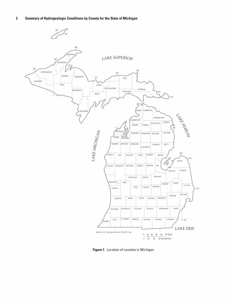
Figures 1. Location of counties in Michigan .................................................................................................2
Kent County ..........................................................................................................................................37Keweenaw County ..............................................................................................................................39Lake County..........................................................................................................................................39Lapeer County......................................................................................................................................40Leelanau County..................................................................................................................................41Lenawee County..................................................................................................................................42Livingston County ................................................................................................................................43Luce County .........................................................................................................................................44Mackinac County ................................................................................................................................45Macomb County ..................................................................................................................................46Manistee County .................................................................................................................................47Marquette County ...............................................................................................................................47Mason County......................................................................................................................................48Mecosta County ..................................................................................................................................49Menominee County.............................................................................................................................49Midland County ...................................................................................................................................50Missaukee County ..............................................................................................................................51Monroe County ....................................................................................................................................51Montcalm County ................................................................................................................................53Montmorency County .........................................................................................................................53Muskegon County ...............................................................................................................................54Newaygo County .................................................................................................................................55Oakland County ...................................................................................................................................56Oceana County ....................................................................................................................................57Ogemaw County ..................................................................................................................................57Ontonagon County ..............................................................................................................................58Osceola County ...................................................................................................................................59Oscoda County ....................................................................................................................................59Otsego County .....................................................................................................................................59Ottawa County .....................................................................................................................................60Presque Isle County............................................................................................................................61Roscommon County ............................................................................................................................62Saginaw County ..................................................................................................................................62Sanilac County.....................................................................................................................................63Schoolcraft County .............................................................................................................................64Shiawassee County ............................................................................................................................65St. Clair County ....................................................................................................................................66St. Joseph County ...............................................................................................................................67Tuscola County ....................................................................................................................................68Van Buren County ...............................................................................................................................69Washtenaw County ............................................................................................................................69Wayne County .....................................................................................................................................71Wexford County ...................................................................................................................................72
References Cited.........................................................................................................................................73
iv
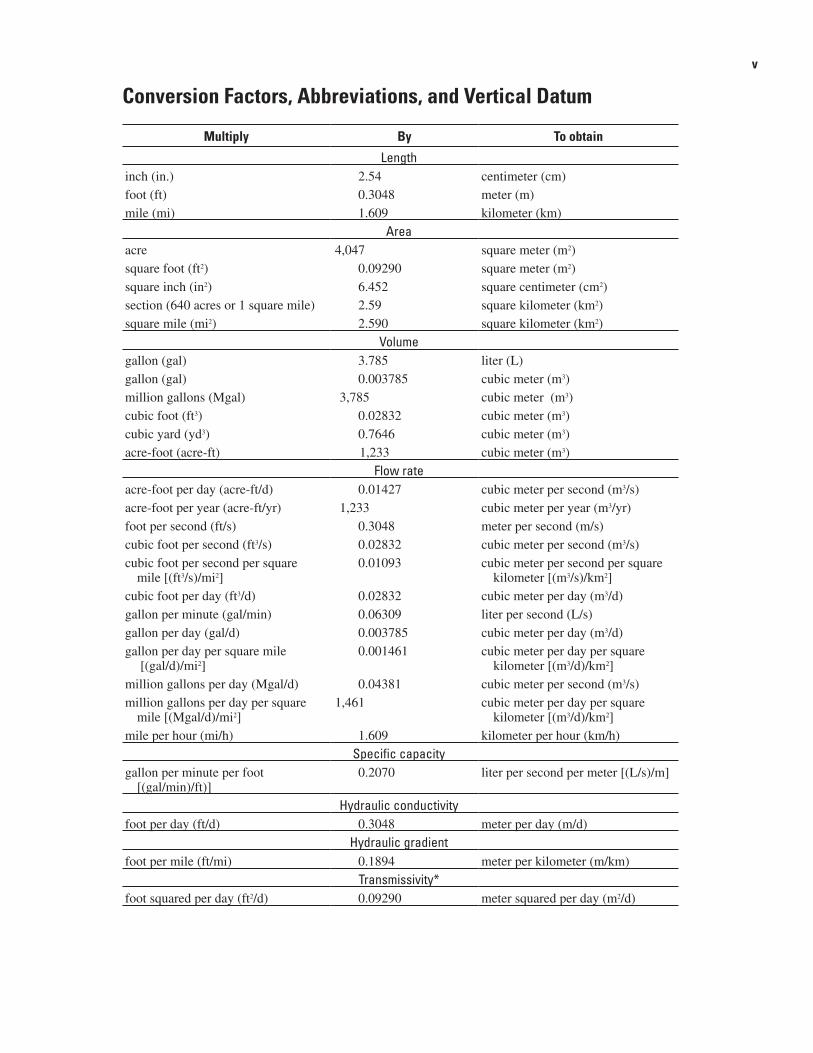
Conversion Factors, Abbreviations, and Vertical Datum
Multiply By To obtain
Lengthinch (in.) 2.54 centimeter (cm)foot (ft) 0.3048 meter (m)mile (mi) 1.609 kilometer (km)
Areaacre 4,047 square meter (m2)square foot (ft2) 0.09290 square meter (m2)square inch (in2) 6.452 square centimeter (cm2)section (640 acres or 1 square mile) 2.59 square kilometer (km2)square mile (mi2) 2.590 square kilometer (km2)
Volumegallon (gal) 3.785 liter (L) gallon (gal) 0.003785 cubic meter (m3) million gallons (Mgal) 3,785 cubic meter (m3)cubic foot (ft3) 0.02832 cubic meter (m3) cubic yard (yd3) 0.7646 cubic meter (m3) acre-foot (acre-ft) 1,233 cubic meter (m3)
Flow rateacre-foot per day (acre-ft/d) 0.01427 cubic meter per second (m3/s)acre-foot per year (acre-ft/yr) 1,233 cubic meter per year (m3/yr)foot per second (ft/s) 0.3048 meter per second (m/s)cubic foot per second (ft3/s) 0.02832 cubic meter per second (m3/s)cubic foot per second per square
mile [(ft3/s)/mi2] 0.01093 cubic meter per second per square
kilometer [(m3/s)/km2]cubic foot per day (ft3/d) 0.02832 cubic meter per day (m3/d)gallon per minute (gal/min) 0.06309 liter per second (L/s)gallon per day (gal/d) 0.003785 cubic meter per day (m3/d)gallon per day per square mile
[(gal/d)/mi2] 0.001461 cubic meter per day per square
kilometer [(m3/d)/km2]million gallons per day (Mgal/d) 0.04381 cubic meter per second (m3/s)million gallons per day per square
mile [(Mgal/d)/mi2]1,461 cubic meter per day per square
kilometer [(m3/d)/km2]mile per hour (mi/h) 1.609 kilometer per hour (km/h)
Specific capacitygallon per minute per foot
[(gal/min)/ft)] 0.2070 liter per second per meter [(L/s)/m]
Hydraulic conductivityfoot per day (ft/d) 0.3048 meter per day (m/d)
Hydraulic gradientfoot per mile (ft/mi) 0.1894 meter per kilometer (m/km)
Transmissivity*foot squared per day (ft2/d) 0.09290 meter squared per day (m2/d)
v

Vertical coordinate information is referenced to the North American Vertical Datum of 1988 (NAVD 88).
Horizontal coordinate information is referenced to the North American Datum of 1983 (NAD 83).
Altitude, as used in this report, refers to distance above the vertical datum.
*Transmissivity: The standard unit for transmissivity is cubic foot per day per square foot times foot of aquifer thickness [(ft3/d)/ft2]ft. In this report, the mathematically reduced form, foot squared per day (ft2/d), is used for convenience.
vi
AbstractSummaries of the major hydrogeologic features for
each county in Michigan are presented. Each summary includes a listing of the major watersheds in the county and a description of the hydrogeology of the major aquifers in the county. Aquifer properties reported in the literature are given if available. Reports describing the hydrogeology of each county are cited. This work was prepared to provide a brief introduction to the ground‑water setting for each county.
Introduction
Purpose and Scope
Public Act 148, Section 32802 (Michigan State Legislature, 2003) required the Department of Environmen‑tal Quality (MDEQ) of the State of Michigan to create a ground‑water inventory and map that includes eight specific requirements, a general requirement for a ground‑water inventory, and a directive to make the map and inventory accessible by the public. This document provides a sum‑mary of hydrogeologic conditions for each county in the State that were prepared for the ground‑water inventory.
The goal of the effort documented by this report was to provide a database of hydrogeologic information for the State. This database indexes reports that describe the hydrogeology and ground‑water resources of the State of Michigan, provides aquifer‑test results from these reports, and provides an overview summary of the hydrogeologic conditions for each county. The database may be searched by county, hydrologic unit code, aquifer type, author, and
various other fields. The database is provided on‑line and is envisioned to provide a first‑stop for State regulators, water‑resources professionals, and the public to gather existing ground‑water resources data for Michigan. The county summaries prepared for the database are provided in this report.
For each county summary, the distribution of wells between wells completed in bedrock aquifers and those glacial deposits is provided using records from the digital water well log database, Wellogic, maintained by the State of Michigan. This distribution is intended to indicate the major local aquifer system used for domestic supply to the reader. Each summary then describes the aquifer characteristics for post‑glacial alluvium, glacial deposits, and bedrock units. Citations are provided to document the summary. The level of detail for each county depends on the available information for the county, and no additional interpretive work was done in the preparation of these summaries. Many of the reports cited in this report are available through the internet at the ground‑water inven‑tory and map website that is maintained by Michigan State University (http://gwmap.rsgis.msu.edu).
Study AreaThe study area for this report is the entire State of
Michigan. This report is a compilation of county hydro‑geologic summaries created for the ground‑water inven‑tory. Each county summary is designed to provide a brief overview of the ground‑water resources in the county.
Summary of Hydrogeologic Conditions by County for the State of Michigan
By Beth A. Apple and Howard W. Reeves
Base from U.S. Geological Survey 1:500,000 map
90o
48o
89o
47o
88o
87o
84o
46o
45o
83o
44o
43o
42o
86o85o
LEELANAU
EMMET CHEBOYGAN
PRESQUE ISLECHARLEVOIX
ANTRIM OTSEGOMONTMORENCY ALPENA
BENZIE GRANDTRAVERSE
KALKASKA CRAWFORD OSCODA ALCONA
MANISTEE WEXFORD MISSAUKEE
ROSCOMMON
OGEMAW IOSCO
MASON LAKE OSCEOLA CLARE GLADWIN ARENAC
OCEANA NEWAYGO MECOSTA ISABELLA MIDLAND BAY
HURON
MUSKEGON KENT
MONTCALM GRATIOT SAGINAW
TUSCOLA SANILAC
OTTAWA IONIA CLINTON SHIAWASSEE
GENESEE LAPEER
ALLEGAN BARRY EATON INGHAM LIVINGSTONOAKLAND
VAN BUREN KALAMAZOO CALHOUN JACKSON WASHTENAW WAYNE
BERRIENCASS ST JOSEPH BRANCH HILLSDALE LENAWEE MONROE
MACOMB
ST CLAIR
KEWEENAW
HOUGHTON
ONTONAGON
GOGEBIC
IRON
BARAGA MARQUETTE
DICKINSON
ALGER
MENOMINEE
DELTA
SCHOOLCRAFT
LUCE
MACKINACCHIPPEWA
89o
0 4010 20 30 50 MILES
0 4020 60 KILOMETERS
SAGIN
AW
BAY
LAKE
MIC
HIG
AN
LAKEH
URO
N
LAKE ERIE
LAKE SUPERIOR
439
� Summary of Hydrogeologic Conditions by County for the State of Michigan
Figure 1. Location of counties in Michigan.
County Summaries
Alcona County
Alcona County is in the northeastern portion of the Lower Peninsula of Michigan. The Lone Lake‑Ocqueoc, Thunder Bay, Au Sable, and Lake Huron watersheds drain the county. According to the February 2005 Wellogic database, approximately 94 percent of the wells in Alcona County are completed in the glacial deposits, and less than 1 percent in the bedrock units. There is insufficient information to make this distinction for 6 percent of the wells in the county.
With the available information, glacial lithologies cannot be regionally correlated in the subsurface in the Michigan Basin. This is likely due to the lateral and vertical hetero‑geneity of glacial deposits that resulted from a complex depositional history (Westjohn and others, 1994). The glacial deposits in Alcona County range from 101 to 800 ft thick. However, the majority of the deposits range from 201 to 600 ft thick (Western Michigan University, 1981). The glacial depos‑its consist of till, outwash, and lacustrine deposits. Fine‑ to coarse‑grained till occurs in moraines and till plains. Glacial outwash and ice‑contact outwash is also present in the county, and primarily consists of sand and gravel. Coarse‑grained lacustrine deposits are present on the surface in the south‑cen‑tral, southeastern, and northeastern portions of the county (Farrand and Bell, 1982). Aquifers in the glacial deposits consist largely of sands and gravels and vary regionally in thickness and permeability.
Bedrock underlies the glacial deposits. The bedrock surface of Alcona County is composed of the Marshall Sand‑stone, Coldwater Shale, Sunbury Shale, Berea Sandstone, Bedford Shale, and Antrim Shale (Milstein, 1987). The Mar‑shall Sandstone forms the bedrock surface in the southwestern portion of the county. The Marshall Sandstone consists of one or more stratigraphically continuous permeable sandstones. The upper sandstone is a quartzarenite to sublitharenite that is referred to as the Napoleon Sandstone Member. A shale, siltstone, and/or carbonate layer separates the Napoleon Sand‑stone Member from the underlying lower Marshall sandstone. The lower Marshall sandstone is comprised of two units. The upper unit is generally 50 to 125 ft of fine‑ to medium‑grained quartzarenite to sublitharenite. The basal unit is a fine‑ to medium‑grained litharenite that ranges in thickness from 30 to 125 ft. Permeable sandstones in the Marshall Sandstone comprise the Marshall aquifer. The Marshall aquifer ranges in thickness from 75 to greater than 200 ft within the State (Westjohn and Weaver, 1998). The Marshall aquifer contains fresh water in Alcona County (Westjohn and Weaver, 1996c).
The Coldwater Shale underlies the Marshall Sandstone, and consists of primarily shale with interbeds or lenses of sandstone, siltstone, and dolomite. The Coldwater Shale is relatively impermeable and is considered a confining unit in most of Michigan (Westjohn and Weaver, 1998).
The Sunbury Shale is a black, carbonaceous shale that underlies the Coldwater Shale (Harrell and others, 1991). The Sunbury Shale thins towards the center of the Michigan Basin and is 147.6 ft thick in the eastern portion of the State (Guts‑chick and Sandberg, 1991). Shale is generally considered to be a confining unit.
The Berea Sandstone underlies the Sunbury Shale. The Berea Sandstone is fine‑ to medium‑grained sandstone, and is greater than 114.8 ft thick in eastern Michigan and thins to the west (Gutschick and Sandberg, 1991). The Berea Sand‑stone grades into the underlying Bedford Shale and thus the upper portion of the shale is silty or sandy. The Bedford Shale is primarily gray shale in the Michigan Basin. The Bedford Shale may be greater than 213.3 ft thick in eastern Michigan and thins toward the center of the Michigan Basin (Gutschick and Sandberg, 1991). Shale is generally considered to be a confining unit.
The Antrim Shale is composed of primarily carbona‑ceous, black to dark‑gray shale. Near the base of the sequence, thin layers of gray shale and limestone may occur. The major constituents in the Antrim Shale consist of quartz, illite, and kerogen. Kaolinite, chlorite, and pyrite also compose the Ant‑rim Shale. The Antrim Shale has been found to have bitumi‑nous limestone concretions up to 3 ft in diameter (Matthews, 1993). The Antrim Shale can be up to 656 ft thick, which occurs at the center of the Michigan Basin (Gutschick and Sandberg, 1991). Antrim Shale is generally not considered to be an aquifer, however, locally it may yield small quantities of water.
Alger County
Alger County is in the central portion of the Upper Peninsula of Michigan. The Betsy‑Chocolay, Tahquamenon, Lake Superior, Tacoosh‑Whitefish, Fishdam‑Sturgeon, and Manistique watersheds drain the county. According to the February 2005 Wellogic database, approximately 28 percent of the wells in Alger County are completed in the glacial depos‑its, and 68 percent in the bedrock units. There is insufficient information to make this distinction for 4 percent of the wells in the county. The glacial aquifer is generally unconfined, and overlies the bedrock aquifers, except where glacial deposits are absent.
Aquifers in the glacial deposits consist largely of sands and gravels and vary regionally in thickness and permeability. With the available information, glacial lithologies cannot be regionally correlated in the subsurface. This is likely due to the lateral and vertical heterogeneity of glacial deposits that resulted from a complex depositional history (Westjohn and others, 1994). The glacial deposits range from 0 to greater than 200 ft thick in Alger County, and include lacustrine deposits, till, and outwash. Sand is the major constituent in lacustrine deposits, which locally overlie other types of glacial deposits. The lacustrine deposits yield moderate supplies of water. Till is present in moraines and till plains. The Munising and New‑
County Summaries �
berry Moraines are present in Alger County. The Munising Moraine trends from the northeast to the southwest. The New‑berry Moraine is present in T45N R19W and T44N R19W. The moraines are composed primarily of sandy till with lenses of sand and gravel outwash interbedded. The morainal depos‑its may yield small to moderate supplies of water. Till‑plain deposits, which consist of sandy‑clay or boulder till, generally do not supply water. The outwash deposits consist of primar‑ily sand and some gravel (Vanlier, 1963b). Where the outwash deposits are the most extensive, Vanlier (1963b) estimates the average thickness to be 100 ft. Outwash deposits may yield moderate to large water supplies, which locally has high iron content.
Specific capacities range from 1 to 14 gal/min/ft for the glacial aquifer in Pictured Rocks National Lakeshore (Handy and Twenter, 1985). Based upon eight wells located near the Wetmore tribal community, glacial aquifer transmissivity ranges from 95 to 310 ft2/day (Brannen, 1997). According to the Public Water Supply database, the estimated transmissiv‑ity for glacial wells in the county ranges from approximately 2,150 to 5,615 ft2/day.
Glacial deposits, when present, overlie the bedrock units. The units that form the bedrock surface generally subcrop trending southwest to northeast. The youngest units form the bedrock surface in the southeastern portion of the county and get progressively older to the northwest. Due to the angle of the bedrock, which dips south, the layers diminish to the north. The Trenton Formation and underlying Black River Formation, which are composed of limestone and dolomite with interbedded shale, are the uppermost bedrock units in the county. This combined layer is thinner in the northern portion of the county and is the major source of water in the south‑western portion of the county. The Trenton and Black River Formations supply small yields of hard water with high iron concentrations. Bacterial contamination is also a problem in water from this layer. In some areas, impermeable layers in the Trenton and Black River Formations act as confining layers (Vanlier, 1963b).
Vanlier (1963b) defines the bedrock underlying the Tren‑ton and Black River Formations as Ordovician and Cambrian dolomite and sandstone undifferentiated. Handy and Twenter (1985) define this same layer as the Prairie du Chien Group and underlying Trempealeau Formation. Dolomite in this layer can supply small amounts of water, usually in the western part of Alger County, where the sandstone from this layer is thin or not present. In other areas of the county, the sandstone member supplies water. Based on nine wells completed in the Prairie du Chien Group, near the Wetmore tribal community, bedrock aquifer transmissivity ranges from 6.7 to 26.7 ft2/day (Brannen, 1997). The Munising Formation and Jacobsville Sandstone underlie this layer.
The Munising Formation is composed of a fine‑ to medi‑um‑grained quartz sandstone, with lenses of coarser sandstone, and a basal conglomerate layer. The Munising Formation supplies good quality water and is the most extensive aquifer in Alger County. However, the Munising Formation does not
supply many wells with water, because shallower ground‑wa‑ter resources are available. The Munising Formation may be semi‑confined or confined in areas because the upper portion of the formation is silty to shaley (Vanlier, 1963b). Specific capacities are near 1 gpm/ft for the Munising Formation in Pictured Rocks National Lakeshore (Handy and Twenter, 1985). According to the Public Water Supply database, the estimated transmissivity for wells completed in the Munising Formation is approximately 535 ft2/day.
The Jacobsville Sandstone, which lies underneath the Munising Formation, is moderately permeable from joints and fractures in the upper third of the formation, especially where it forms the bedrock surface. The greatest thickness of Jacobsville Sandstone is 1,000 ft along the shore of Lake Superior and thins to the south. Jacobsville Sandstone is pre‑dominately medium‑grained sandstone interbedded with shale, siltstone, and coarser sandstone (Vanlier, 1963b). Specific capacities range between 0.1 to 1 gal/min/ft for the Jacobsville Sandstone in Pictured Rocks National Lakeshore (Handy and Twenter, 1985). The Jacobsville Sandstone supplies hard water with high concentrations of iron. In some wells, the water from Jacobsville Sandstone is saline (Vanlier, 1963b). Igneous and metamorphic Precambrian rocks underlie the Jacobsville Sandstone and are not a source of water (Handy and Twenter, 1985).
Allegan County
Allegan County is in the southwestern Lower Peninsula of Michigan. The western edge of the county is along the Lake Michigan shoreline. The Lake Michigan, Black‑Macatawa, Kalamazoo, Lower Grand, and Thornapple watersheds drain the county. According to the February 2005 Wellogic data‑base, approximately 89 percent of the wells in Allegan County are completed in the glacial deposits, and 8 percent in the bedrock units. There is insufficient information to make this distinction for 3 percent of the wells in the county.
With the available information in the State, glacial lithologies cannot be regionally correlated in the subsurface. This is likely due to the lateral and vertical heterogeneity of glacial deposits that resulted from a complex depositional history (Westjohn and others, 1994). The surficial deposits in Allegan County consist of dunes, lacustrine deposits, outwash and small amounts of post‑glacial alluvium, and till. Dune sand primarily exists in the western portion of the county along Lake Michigan. Lacustrine deposits are primarily sand and gravel and are concentrated in the center of the county. Outwash and post‑glacial alluvium deposits occur mostly in the eastern portion of the county and are composed of sand and gravel. Till is present in till plains and moraines. The till in Allegan County ranges from fine to coarse grained (Farrand and Bell, 1982).
Aquifers in the glacial deposits consist largely of sands and gravels, and vary regionally in thickness and permeability. According to the Public Water Supply database, the outwash
� Summary of Hydrogeologic Conditions by County for the State of Michigan
deposits have estimated transmissivities from aquifer tests that range from 9,547 to 79,900 ft2/day, while combined outwash and till have an estimated transmissivity of 6, 496 ft2/day.
Bedrock underlies the glacial deposits. The bedrock sur‑face in Allegan County is composed of the Michigan Forma‑tion, Marshall Sandstone, and Coldwater Shale. The Michigan Formation subcrops in a small area in the northeastern portion of the county. Discontinuous siltstone and sandstone lenses, along with shale, carbonate, and evaporite comprise the Michigan Formation. The Michigan Formation is considered a confining unit (Westjohn and Weaver, 1996b).
The Marshall Sandstone underlies the Michigan Forma‑tion and subcrops in the northeastern portion of the county. The greatest thickness of the Marshall Sandstone is 171 ft in Allegan County (Riggs, 1938). The Marshall Sandstone is composed of an upper quartzarenite to sublitharenite that is referred to as the Napoleon Sandstone Member (Riggs, 1938). A shale, siltstone, and/or carbonate layer separates the Napo‑leon Sandstone Member from the lower Marshall sandstone. The lower Marshall Sandstone is comprised of two units. The upper unit is generally 50 to 125 ft of fine‑ to medium‑grained quartzarenite to sublitharenite. The basal unit is a fine‑ to medium‑grained litharenite that ranges in thickness from 30 to 125 ft (Westjohn and Weaver, 1998). Both the Napoleon Sandstone Member and lower Marshall Sandstone are pres‑ent in well logs from Allegan County (Riggs, 1938). Perme‑able sandstones in the Marshall Sandstone are considered the Marshall aquifer. The Marshall aquifer ranges in thickness between 75 and greater than 200 ft thick within the State (Westjohn and Weaver, 1998). The Marshall aquifer yields fresh water in Allegan County (Westjohn and Weaver, 1996c).
The Coldwater Shale underlies the Marshall Sandstone. The Coldwater Shale subcrops in the central and western por‑tion of Allegan County. In the County, the Coldwater Shale ranges from 700 to 860 ft thick when beneath the Marshall Sandstone. Coldwater Shale consists of shale, sandstone, siltstone, and carbonates. In Allegan County, cherty shale that contains dolomite crystals, chert bands and dolomitic lime‑stone are common in the Coldwater Shale. Limestone layers may provide water to wells in areas of the county. However, the water may be saline (Riggs, 1938).
Alpena County
Alpena County is in the northeastern Lower Peninsula of Michigan. The Lone Lake‑Ocqueoc, Thunder Bay, Au Sable, and Lake Huron watersheds drain portions of Alpena County. According to the February 2005 Wellogic database, approxi‑mately 39 percent of the wells in Alpena County are com‑pleted in the glacial deposits, and 41 percent in the bedrock units. There is insufficient information to make this distinction for 20 percent of the wells in the county. Glacial wells are more abundant in the southern portion of the county, while bedrock wells dominate the northern portion of the county.
In the Michigan Basin, glacial aquifers consist of sand and gravel that are part of a thick sequence of Pleistocene gla‑cial deposits. With the available information, glacial litholo‑gies cannot be regionally correlated in the subsurface. This is likely due to the lateral and vertical heterogeneity of glacial deposits that resulted from a complex depositional history (Westjohn and others, 1994). Glacial deposits are up to 600 ft thick in Alpena County (Western Michigan University, 1981). The glacial deposits in the county consist of till, outwash, and lacustrine deposits. The western and central portion of the county is primarily composed of coarse‑grained till. Eskers are present in central portion of the county. Fine‑grained till can also be found on the surface, but does not make up a large percentage of the glacial deposits in the county. Outwash and ice‑contact outwash are found throughout the southwest‑ern and southeastern portions of the county, respectively. Coarse‑grained lacustrine deposits are present on the surface in the northeastern portion of the county and along the eastern border. In addition, sand dunes composed of fine‑ to medi‑um‑grained sand are present along the Lake Huron shoreline and are also found inland. An area of peat and muck deposits can be found in the northwestern portion of the county (Far‑rand and Bell, 1982).
The glacial deposits overlie the bedrock. The bedrock surface of Alpena County is composed of the Sunbury Shale, Berea Sandstone, Bedford Shale, Antrim Shale, and Traverse Group. Sunbury Shale, Berea Sandstone, and Bedford Shale subcrop in the southwestern portion of the county. The Antrim Shale and Traverse Group form the remainder of the bedrock surface in the northern and southern portions of the county, respectively (Milstein, 1987).
The Sunbury Shale is a black shale, which thins towards the center of the basin and is 147 ft thick in the eastern portion of the State (Gutschick and Sandberg, 1991). The Berea Sand‑stone underlies the Sunbury Shale. The Berea Sandstone is fine‑ to medium‑grained sandstone. It is greater than 114.8 ft thick in eastern Michigan and thins to the west (Gutschick and Sandberg, 1991). The Berea Sandstone grades into the under‑lying Bedford Shale and thus the upper portion of the shale is silty or sandy. The Bedford Shale is primarily gray shale in the Michigan Basin. The Bedford Shale may be greater than 213 ft thick in eastern Michigan and thins toward the center of the Michigan Basin (Gutschick and Sandberg, 1991).
The Antrim Shale is composed of primarily carbona‑ceous, black to dark‑gray shale. Near the base of the sequence, thin layers of gray shale and limestone may occur. The major constituents in the Antrim Shale consist of quartz, illite, and kerogen. Kaolinite, chlorite, and pyrite also compose the Ant‑rim Shale. The Antrim Shale has been found to have bitumi‑nous limestone concretions up to 3 ft in diameter (Matthews, 1993). The Antrim Shale can be up to 656 ft thick, which occurs at the center of the Michigan Basin (Gutschick and Sandberg, 1991).
The Traverse Group primarily consists of fossiliferous limestone. In the western portion of the basin, porous dolo‑mite and anhydrite may be present. In the eastern portion of
County Summaries �
the basin, interlayers of shale are common. (Gardner, 1974). The basal formation of the Traverse Group is the Bell Shale. Bell Shale has a maximum thickness of 80 ft (Catacosinos and others, 2001). The majority of the bedrock wells in the county occur where the Traverse group forms the bedrock surface.
There are several karst features that occur throughout the northern portion of the county. The karst features are a result of dissolution of the carbonate and evaporite bedrock units and subsequent collapse of these units. Karst sinkhole lakes occur near Leer in Alpena County. Devil’s, Long, Fitzgerald, and Mindack Lakes are considered karst solution lakes (Kimmel, 1983).
Antrim County
Antrim County is in the northwestern Lower Peninsula. The Manistee, Boardman‑Charlevoix, and Lake Michigan watersheds can be found in the county. According to the Feb‑ruary 2005 Wellogic database, approximately 94 percent of the wells in Antrim County are completed in the glacial deposits, and less than 1 percent in the bedrock units. There is insuf‑ficient information to make this distinction for 6 percent of the wells in the county. The majority of the bedrock wells are along the western shoreline.
In the Michigan Basin, glacial aquifers consist of sand and gravel that are part of a thick sequence of Pleistocene glacial deposits. With the available information, glacial lithologies cannot be regionally correlated in the subsurface. This is likely due to the lateral and vertical heterogeneity of glacial deposits that resulted from a complex depositional history (Westjohn and others, 1994). In Antrim County, the glacial deposits range from 11 to 1,000 ft thick; however, the majority of the deposits range from 200 to 800 ft in thickness (Western Michigan University, 1981). The glacial deposits are composed of outwash, till, and lacustrine deposits. Outwash consists of sand and gravel and is most abundant in the eastern portion of the county. An isolated area of ice‑contact outwash is in the southeastern corner of the county. The till found in Antrim County is primarily coarse grained and occurs in moraines and till plains. A small amount of medium‑grained till occurs in the southwestern portion of the county. Moraines trend southwest to northeast across the county. Drumlins are abundant on the till plains in the northwestern portion of the county. The lacustrine deposits are composed primarily of sand and gravel and are concentrated in the western portion of the county (Farrand and Bell, 1982). According to the Public Water Supply database, the estimated transmissivity for glacial wells ranges from approximately 1,200 to 14,170 ft2/day.
According to the Public Water Supply database, the estimated transmissivity for a bedrock well in the county is approximately 2,320 ft2/day. The bedrock surface in Antrim County consists of the Coldwater Shale, Sunbury Shale, Berea Sandstone, Bedford Shale, Antrim Shale, Ellsworth Shale, and Traverse Group (Milstein, 1987). Within the State, the Coldwater Shale consists of primarily shale with interbeds, or
lenses, of sandstone, siltstone, and dolomite. The Coldwater Shale is relatively impermeable and is considered a confining unit in most of Michigan (Westjohn and Weaver, 1998).
The Sunbury Shale is black shale that thins towards the center of the basin and is 147.6 ft thick in the eastern por‑tion of the State (Gutschick and Sandberg, 1991). This unit is generally not considered an aquifer. The Berea Sandstone underlies the Sunbury Shale. The Berea Sandstone is fine‑ to medium‑grained sandstone. It is greater than 114.8 ft thick in eastern Michigan and thins to the west. The Berea Sandstone grades into the underlying Bedford Shale and thus the upper portion of the shale is silty or sandy (Gutschick and Sandberg, 1991).
Like the Sunbury Shale, the Bedford, Ellsworth, and Antrim Shales are generally not considered aquifers. The Bedford Shale is primarily gray shale in the Michigan Basin. The Bedford Shale may be greater than 213.3 ft thick in eastern Michigan and thins toward the center of the Michigan Basin (Gutschick and Sandberg, 1991). The Ellsworth Shale is composed of a gray to greenish‑gray shale. Ellsworth Shale generally contains some dolomite and may also be composed of sandstone and siltstone layers (Matthews, 1993). The Antrim Shale is composed of primarily carbonaceous, black to dark‑gray shale. Near the base of the sequence, thin layers of gray shale and limestone may occur. The major constituents of the Antrim Shale consist of quartz, illite, and kerogen. Kaolin‑ite, chlorite, and pyrite also compose the Antrim Shale. The Antrim Shale has been found to have bituminous limestone concretions up to 3 ft in diameter (Matthews, 1993). The Ant‑rim Shale can be up to 656 ft thick, which occurs at the center of the Michigan Basin (Gutschick and Sandberg, 1991).
The Traverse Group primarily consists of fossiliferous limestone. In the western portion of the basin, porous dolo‑mite and anhydrite may be present. In the eastern portion of the basin, interlayers of shale are common. (Gardner, 1974). Nearby in Charlevoix County, the transmissivity of the lime‑stone ranges from 13.4 to 5,347.2 ft2/day (Cathcart, 1982). The basal formation of the Traverse Group is the Bell Shale. Bell Shale has a maximum thickness of 80 ft (Catacosinos and others, 2001).
Arenac County
Arenac County is in the eastern north‑central portion of the Lower Peninsula of Michigan. The eastern portion of the county borders Saginaw Bay. The county is considered part of the Saginaw Lowlands (Westjohn and Weaver, 1998). The Au Gres‑Rifle, Kawkawlin‑Pine, Tittabawassee, and Lake Huron watersheds drain the county. According to the February 2005 Wellogic database, approximately 41 percent of the wells in Arenac County are completed in the glacial deposits, and 56 percent in the bedrock units. There is insufficient informa‑tion to make this distinction for 3 percent of the wells in the county.
� Summary of Hydrogeologic Conditions by County for the State of Michigan
In the Michigan Basin, glacial aquifers consist of sand and gravel that are part of a thick sequence of Pleistocene gla‑cial deposits. With the available information, glacial litholo‑gies cannot be regionally correlated in the subsurface. This is likely due to the lateral and vertical heterogeneity of glacial deposits that resulted from a complex depositional history (Westjohn and others, 1994). The thickness of glacial deposits in Arenac County ranges from 0 ft in the west to 400 ft in the northwest (Western Michigan University, 1981). The glacial deposits in Arenac County are composed of primarily basal lodgement till and lacustrine deposits (Westjohn and Weaver, 1994). Sand and gravel lacustrine deposits are primarily in the central and northern parts of the county, while clay and silt‑lacustrine deposits are common in the southern and eastern parts of the county (Farrand and Bell, 1982). Moraines are also present in Arenac County. The Port Huron Moraine trends northeastward, from the southwestern corner of the county into Clayton and Mason Townships. Moraines are also present in the northeastern portion of Whitney Township, the northwest portion of Moffat Township, and the northwestern most corner of the county. The till comprising the moraines is generally composed of boulder‑rich clay, with areas of sand (Pringle, 1937). According to the Public Water Supply database, glacial wells in Arenac County have estimated transmissivities from aquifer tests that range from 495 to 3,450 ft2/day.
Bedrock underlies the glacial deposits, except where bed‑rock outcrops are present (Pringle, 1937). The bedrock surface of Arenac County is composed of the Saginaw Formation, Bayport Limestone, Michigan Formation, Marshall Sandstone, and Coldwater Shale (Milstein, 1987). Bedrock generally dips to the southwest (Pringle, 1937). According to the Public Water Supply database the estimated transmissivity from aqui‑fer tests for a bedrock well in Arenac County was 136 ft2/day.
In Arenac County, the thickness of the Saginaw Forma‑tion ranges from 90 ft, near Rifle River, and increases to the southwest to Adams Township, where it is greater than 250 ft (Pringle, 1937). Interbedded sandstone, siltstone, shale, coal, and limestone compose the Saginaw Formation The Saginaw aquifer consists of hydraulically‑connected sandstones in the Saginaw Formation (Westjohn and Weaver, 1998). Within the State, the Saginaw aquifer ranges from less than 100 to 370 ft thick. The Saginaw aquifer yields fresh and saline water in the southwest and southeast portions of Arenac County, respec‑tively (Westjohn and Weaver, 1996c). The Saginaw confining unit underlies the Saginaw aquifer. The Saginaw confining unit ranges from less than 100 to 240 ft thick within the State, and is mostly shale, with thin layers of discontinuous sand‑stone, siltstone, limestone, and coal. The permeable layers within the Saginaw confining unit appear to be isolated from the regional ground‑water‑flow system (Westjohn and Weaver, 1996a).
The Saginaw confining unit separates the Saginaw aqui‑fer from the underlying Parma‑Bayport aquifer. The Parma Sandstone is often considered the basal unit of the Saginaw Formation, although the stratigraphic relationship is not clear between the Saginaw Formation, Parma Sandstone, and
Mississippian‑aged Bayport Limestone. The Parma Sandstone is composed of medium‑ to coarse‑grained sandstone (Cohee and others, 1951). In some areas in Arenac County, the Parma Sandstone is completely eroded; however, where the Parma Sandstone is present, it ranges in thickness from 30 to 50 ft (Pringle, 1937). The Bayport Limestone is a fossiliferous, cherty limestone, often with interbedded sandstone and var‑ies considerably in thickness from one area to another. The Bayport Limestone and Parma Sandstone appear to interfin‑ger throughout the Michigan Basin (Westjohn and Weaver, 1996a). These units are hydraulically connected, and together they form the Parma‑Bayport aquifer (Westjohn and Weaver, 1996a). The Parma‑Bayport aquifer is approximately 100 to 150 ft thick within the Michigan Basin. Please note that due to the uncertainty of stratigraphic relationship between these units, in other reports this aquifer may be delineated differently. The Parma‑Bayport aquifer yields saline water in Arenac County (Westjohn and Weaver, 1996c).
Underlying the Bayport Limestone is the Michigan Formation. The Michigan Formation consists of layers of clay‑rich, fine‑grained sandstone, siltstone, anhydrite or gyp‑sum, dolomite, limestone, and shale (Pringle, 1937; Westjohn and Weaver, 1996b). The Michigan Formation ranges from 30 to 260 ft thick in the county. However, generally in Arenac County, the Michigan Formation is less than 100 ft thick (Prin‑gle, 1937). The lower permeability lithologies of the Michigan Formation are considered a confining unit that separates the Parma‑Bayport aquifer from the underlying Marshall aquifer (Westjohn and Weaver, 1996b).
The Marshall Sandstone underlies the Michigan Forma‑tion. The Marshall Sandstone consists of one or more strati‑graphically continuous permeable sandstones. The upper sandstone is a quartzarenite to sublitharenite that is referred to as the Napoleon Sandstone Member (Westjohn and Weaver, 1998). In Arenac County, the Napoleon Sandstone Member varies from 100 to 270 ft thick (Pringle, 1937). A shale, silt‑stone, and/or carbonate layer separates the Napoleon Sand‑stone Member from the lower Marshall sandstone. The lower Marshall sandstone is comprised of two units, which com‑bined range from 70 to 250 ft in thickness in Arenac County (Pringle, 1937; Westjohn and Weaver, 1998). The upper unit is generally 50 to 125 ft of fine‑ to medium‑grained quartzarenite to sublitharenite. The basal unit is a fine‑ to medium‑grained litharenite that ranges in thickness from 30 to 125 ft. Per‑meable sandstones in the Marshall Sandstone comprise the Marshall aquifer. The Marshall aquifer ranges in thickness from 75 to greater than 200 ft within the State (Westjohn and Weaver, 1998). The Marshall aquifer is capable of supplying large quantities of water. The Marshall aquifer yields mostly saline water in Arenac County, except for an area in the north‑ern portion of the county, where the aquifer yields fresh water (Westjohn and Weaver, 1996c).
The Coldwater Shale underlies the Marshall Sandstone, and consists of primarily blue and gray shale with interbeds, or lenses, of sandstone, siltstone, and dolomite (Pringle, 1937; Westjohn and Weaver, 1996b). The Coldwater Shale is rela‑
County Summaries �
tively impermeable and is considered a confining unit in most of Michigan (Westjohn and Weaver, 1996b).
Baraga County
Baraga County is in the western portion of the Upper Peninsula of Michigan. Sturgeon, Dead‑Kelsey, Lake Supe‑rior, Brule, and Michigamme watersheds can be found in the county. According to the February 2005 Wellogic database, approximately 17 percent of the wells in Baraga County are completed in the glacial deposits, and 75 percent in the bedrock units. There is insufficient information to make this distinction for 8 percent of the wells in the county. Most wells in the county only produce small yields suitable for domestic use. Doonan and Byerlay (1973) identify a layer of swamp deposits and Holocene alluvium, the glacial aquifer, and three bedrock aquifers: the Jacobsville Sandstone, the Marquette Range Supergroup, and Laurentian granite and gneiss. It is not clear which aquifers are confined or unconfined.
Swamp deposits, consisting of muck and silt, and Holo‑cene alluvium are concentrated in the northwestern portion of the county and also occur sporadically in patches. Small yields of water are possible from the swamp deposits and Holocene alluvium, but may be high in iron concentrations (Doonan and Byerlay, 1973).
Aquifers in the glacial deposits consist largely of sands and gravels, and vary regionally in thickness and permeabil‑ity. Glacial deposits are composed of till, outwash, stream deposits, and lacustrine deposits. Unstratified glacial depos‑its include sandy to clayey till in moraines and till plains. Stratified deposits that are composed of till include: kames, kame terraces, and eskers. Other stratified glacial deposits are sand and gravel outwash, stream deposits, and clay and sand lacustrine deposits. Three major moraines have been identi‑fied in Baraga County. The Keweenaw Moraine lies along the Keweenaw Bay. The Marenisco Moraine is located in the southern portion of the county. The Covington Moraine trends northeast from the Marenisco Moraine, near Covington. Small to moderate yields of water may be obtained from moraines. Outwash deposits are dispersed throughout the county and are often covered by postglacial deposits. However, the largest area of outwash in the county is located near the Keweenaw Moraine and is partially overlain by lacustrine deposits. In the west‑central portion of the county, is the largest lacustrine deposit. This deposit is up to 200 ft thick. Lacustrine depos‑its yield moderate supplies of water in Baraga County. The transmissivity of the glacial aquifer was calculated using the specific capacity values of Doonan and Byerlay (1973) and ranges from 20 to 3,948 ft2/day. Ground‑water supplies from the glacial aquifer tend to be high in iron, and occasionally have a low pH. The water ranges from soft to very hard and may be high in iron content. (Doonan and Byerlay, 1973).
Bedrock underlies glacial deposits, where glacial deposits are present. In areas where glacial deposits are absent or thin, water must be obtained from the bedrock aquifers. The
transmissivity of the bedrock aquifers was calculated using the specific capacity values of Doonan and Byerlay (1973) and ranges from 1 to 600 ft2/day. About half the bedrock wells in Baraga County acquire water from the Jacobsville Sand‑stone. Water from the Jacobsville Sandstone ranges from soft to very hard and iron concentration varies. Small amounts of water are obtained from fractures within the upper portion of the Marquette Range Supergroup. Water from the Marquette Range Supergroup is usually moderately hard to very hard. Laurentian granite and gneiss may also provide small yields of water from fractures. However, the water is hard and contains iron (Doonan and Byerlay, 1973).
Barry County
Barry County is in the southwestern Lower Peninsula of Michigan. The Thornapple and Kalamazoo watersheds drain the county. According to the February 2005 Wellogic database, approximately 88 percent of the wells in Barry County are completed in the glacial deposits, and 9 percent in the bedrock units. There is insufficient information to make this distinction for 3 percent of the wells in the county. The Marshall aquifer is the primary bedrock aquifer in the county.
With the available information, glacial lithologies cannot be regionally correlated in the subsurface. This is likely due to the lateral and vertical heterogeneity of glacial deposits that resulted from a complex depositional history (Westjohn and others, 1994). The glacial deposits in Barry County range in thickness from 150 to 400 ft (Lilienthal, 1974). Glacial depos‑its in the county include till, outwash, and lacustrine deposits. End moraines in the county are the result of the retreat of the Lake Michigan and Saginaw Lobes of the Laurentide Ice Sheet. The moraines present from the Lake Michigan Lobe occur in the west and southwestern portions of the county, and trend generally southwest to northeast. This moraine is predominantly poorly‑sorted, coarse‑grained till, composed of sand and gravel, and has stony, boulder‑rich till interbedded. The moraines formed from the Saginaw Lobe trend gener‑ally from the northeast to southwest and are located in the northwestern, central, and eastern portion of the county. These moraines are composed of poorly sorted, coarse deposits that fine toward the till plains. Till plains are located in the north‑ern and eastern parts of Barry County, and consist of loamy, clayey‑till. Outwash is located throughout the county. Outwash is composed of primarily well‑sorted, sand and gravel. Lacus‑trine clay is dispersed throughout the outwash (Brewer, 1991).
Glacial aquifers consist of sand and gravel that are part of a thick sequence of glacial deposits (Westjohn and others, 1994). In Barry County, the glacial aquifer consists of primar‑ily outwash and morainal deposits. According to the Public Water Supply database, the estimated transmissivity for glacial wells on the outwash plains in the county range from approxi‑mately 12,205 to 31,250 ft2/day. It is common for glacial wells to have high levels of chloride and nitrate in Barry County (Brewer, 1991).
� Summary of Hydrogeologic Conditions by County for the State of Michigan
Bedrock underlies the glacial deposits. The bedrock dips to the northeast. The bedrock surface includes, generally from northeast to southwest, the Saginaw Formation, Bay‑port Limestone, Michigan Formation, Marshall Sandstone, and Coldwater Shale. The Saginaw Formation is composed of sandstone, siltstone, shale, limestone, and coal. Sandstone with layers of shaly sand, sandy shale, and shale predominate the Saginaw Formation in Barry County. In the county, the Saginaw Formation is approximately 50 ft thick (Lilienthal, 1974). The Saginaw Formation is not an important source of water in Barry County.
The Parma Sandstone is often considered the basal unit of the Saginaw Formation, although the stratigraphic rela‑tionship is not clear between the Saginaw Formation, Parma Sandstone, and Mississippian‑aged Bayport Limestone. The Parma Sandstone is composed of medium‑ to coarse‑grained sandstone, and is generally less than 100 ft thick (Cohee and others, 1951). The Bayport Limestone is a fossiliferous, cherty limestone, often with interbedded sandstone. The Bayport Limestone has maximum thickness of 50 ft in the county and thins to the south, southwest, and west (Lilienthal, 1974). The Bayport Limestone and Parma Sandstone appear to interfin‑ger throughout the Michigan Basin (Westjohn and Weaver, 1996a). Locally, both the Parma Sandstone and Bayport Limestone have been highly eroded (Lilienthal, 1974). These units are hydraulically connected, and together they form the Parma‑Bayport aquifer (Westjohn and Weaver, 1996a). Please note that due to the uncertainty of stratigraphic relation‑ship between these units, in other reports this aquifer may be delineated differently. The Parma‑Bayport aquifer only occurs in the northeastern most edge of Barry County, and is 50 ft or less in thickness (Westjohn and Weaver, 1996a). It is not an important aquifer in the county.
The Michigan Formation underlies the Bayport Lime‑stone. The Michigan Formation is composed of sandstone, shale, limestone, and occasional dolomite, which are all gener‑ally low in permeability. Gypsum and anhydrite are present in the Michigan Formation. The Michigan Formation is consid‑ered a confining unit that separates the Parma‑Bayport aquifer from the underlying Marshall aquifer. In Barry County, the Michigan Formation ranges from 150 to 200 ft thick (Lilien‑thal, 1974). In Barry County, some wells have been screened in the Michigan Formation. The water in these wells may yield high calcium and sulfate concentrations (Brewer, 1991).
The Marshall Sandstone underlies the Michigan Forma‑tion and is 350 to 400 ft thick in Barry County (Lilienthal, 1974). The Marshall Sandstone consists of one or more stratigraphically continuous permeable sandstones. The upper sandstone is a quartzarenite to sublitharenite that is referred to as the Napoleon Sandstone Member. A shale, siltstone, and/or carbonate layer separates the Napoleon Sandstone Member from the underlying lower Marshall sandstone. The lower Marshall sandstone is comprised of two units. The upper unit is generally 50 to 125 ft of fine‑ to medium‑grained quartzare‑nite to sublitharenite. At the base of the Marshall Sandstone is a fine‑ to medium‑grained litharenite that ranges in thickness
from 30 to 125 ft. Permeable sandstones in the Marshall Sand‑stone comprise the Marshall aquifer. The Marshall aquifer ranges in thickness from 75 to greater than 200 ft within the State (Westjohn and Weaver, 1998). The Marshall aquifer is the primary bedrock aquifer in Barry County (Brewer, 1991). According to the Public Water Supply database, the estimated transmissivity for wells in the Marshall aquifer in Barry County ranges from approximately 310 to 38,100 ft2/day. In Barry County, the upper portion of the Marshall aquifer may yield fresh water, while the lower portion of the aquifer may yield saline water or brine (Simms, 1988). Westjohn and Weaver (1996c) found the Marshall aquifer to supply fresh water in the majority of the county, excluding an area in the northeast portion of the county where the water is saline.
The Coldwater Shale underlies the Marshall Sandstone. Calcareous shale, with interbeds of silty shale, and thin sand‑stone comprise the Coldwater Shale in Barry County (Lilien‑thal, 1974). In the western portion of the State, the Coldwater Shale contains more carbonate than siltstone or sandstone (Monnett, 1948). The Coldwater Shale is generally considered a confining unit and ranges in thickness, from 500 to 1,300 ft, east to west across the State (Westjohn and Weaver, 1996b).
Bay County
Bay County is in the eastern‑central portion of the Lower Peninsula of Michigan. The county is considered part of the Saginaw Lowlands (Westjohn and Weaver, 1998). Bay County borders Saginaw Bay along a portion of its eastern side. The Kawkalin‑Pine, Pigeon‑Wiscoggin, Tittabawasse, Saginaw, and Lake Huron watersheds are included in the county on the north and central, southeast, northwest and southwest corners, south‑central, and eastern portions of the county, respectively. The availability of ground water is a problem in areas of the county, due to low yields and mineral concentrations. Accord‑ing to the February 2005 Wellogic database, approximately 37 percent of the wells in Bay County are completed in the glacial deposits, and 59 percent in the bedrock units. There is insufficient information to make this distinction for 4 percent of the wells in the county. Glacial sand and gravel deposits, and sandstone from the Saginaw Formation form the two prin‑cipal aquifers in the county.
In the Michigan Basin, glacial aquifers consist of sand and gravel that are part of a sequence of Pleistocene glacial deposits. With the available information, glacial lithologies cannot be regionally correlated in the subsurface. This is likely due to the lateral and vertical heterogeneity of glacial deposits that resulted from a complex depositional history (Westjohn and others, 1994). Glacial deposits are up to 200 ft thick in Bay County (Western Michigan University, 1981). In the southern portion of the county, the greatest thickness of glacial deposits is found in buried valleys. The buried valleys trend northeast to southwest across Williams, Monitor, and Franken‑lust Townships, and southeast to northwest in Merritt Town‑ship (Twenter and Cummings, 1985). Glacial deposits present
County Summaries �
in the county include lacustrine deposits and till. Lacustrine deposits consist of clay and silt‑dominated deposits, and also sand and gravel‑dominated deposits. Fine to medium‑grained till is also present in the county (Farrand and Bell, 1982). In the southern portion of the county, generally, the uppermost 50 to 150 ft of glacial deposits are composed of clay. Locally, the clay may extend to the bedrock surface, contain thin interbeds of silt and fine‑grained sand, or contain thin to 60 ft thick lay‑ers of sand and gravel. Wells tapping clay deposits supply very little, if any, water. In areas of the central‑eastern and south‑eastern of Williams Township, and in northeastern, northwest‑ern, and central‑western parts of Monitor Township, sand and gravel deposits are large and thick enough to be considered an aquifer (Twenter and Cummings, 1985). In Garfield Township, Stark and McDonald (1980) divided the glacial deposits into three units: sand, clay, and sand and gravel. The uppermost unit is composed of proglacial, well‑sorted sand. The sand unit ranges in thickness from 0 to 20 ft, and occurs in narrow ridges across the surface of the area. The clay unit is underlies the sand unit and ranges in thickness from 30 to 164 ft. The clay unit is predominately silt and clay, but also includes sand, gravel, and a clay and gravel mixture. Underlying the clay unit, is the sand and gravel unit, which ranges in thickness from 0 to 131 ft. The sand and gravel unit consists of predomi‑nately sand, gravel, and pebbles, but also consists of a minor amount of silt and clay. The sand and gravel unit is under confined conditions (Stark and McDonald, 1980) and gener‑ally yields potable water (Twenter and Cummings, 1985). However, water from some glacial wells have been reported to be salty (Twenter and Cummings, 1985).
The Saginaw Formation underlies the glacial deposits and forms the bedrock surface in Bay County. The Saginaw For‑mation is, on average, 330 ft thick, and composed of primarily shale, sandstone, and coal and may contain siltstone and lime‑stone. The most abundant unit in this sequence varies locally. The beds are often discontinuous (Twenter and Cummings, 1985). In a study area located in Garfield Township, the upper‑most portion of the Saginaw Formation is an upper shale unit. This unit is composed of two types of shale: hard fissile shale with carbonaceous deposits and pyrite, and massive, soft silty shale. The upper shale unit also contains thin layers of coal, sandstone, and siltstone. The main coal unit has an average thickness of 1.6 ft. In one area of Bay County, up to three beds of coal are present. Underneath the coal is the lower shale unit. This unit is primarily shale with thin layers of quartz‑rich sandstone (Stark and McDonald, 1980). The Saginaw aquifer is comprised of the permeable beds of sandstone within the Saginaw Formation (Westjohn and Weaver, 1996a). Sand‑stone occurs at the base of the formation and is the principal bedrock aquifer. The sandstone is generally quartz‑rich, well sorted, and fine‑grained and may have thin beds of shale or clay in areas (Stark and McDonald, 1980). According to Stark and McDonald (1980), transmissivity values for this layer are between 300 to 380 ft2/day, and the storage coefficient is 0.0001. According to the Public Water Supply database, the estimated transmissivity from aquifer tests for the Sagi‑
naw aquifer in Tuscola County is 2,540 ft2/day. Water from the Saginaw aquifer may be locally high in dissolved solids (Twenter and Cummings, 1985). In Bay County, the Saginaw aquifer only yields freshwater in the northwestern portion of the county (Westjohn and Weaver, 1996c).
The Saginaw confining unit underlies the Saginaw aqui‑fer. The Saginaw confining unit is approximately 50 to 100 ft thick in the county, and is mostly shale, with thin layers of discontinuous sandstone, siltstone, limestone, and coal. The permeable layers within the Saginaw confining unit appear to be isolated from the regional ground‑water‑flow system (West‑john and Weaver, 1996a).
Benzie County
Benzie County is in the northwestern portion of the Lower Peninsula of Michigan. Sleeping Bear Dunes National Lakeshore is in the northwestern portion of the county. The Manistee, Betsie‑Platte, and Lake Michigan watersheds drain the county. According to the February 2005 Wellogic data‑base, approximately 97 percent of the wells in Benzie County are completed in the glacial deposits, and 0 percent in the bedrock units. There is insufficient information to make this distinction for 3 percent of the wells in the county.
In the Michigan Basin, glacial aquifers consist of sand and gravel that are part of a thick sequence of Pleistocene glacial deposits. With the available information, glacial lithologies cannot be regionally correlated in the subsurface. This is likely due to the lateral and vertical heterogeneity of glacial deposits that resulted from a complex depositional his‑tory (Westjohn and others, 1994). Glacial deposits in Benzie County range from 401 to 1,000 ft in thickness. However, the majority of the glacial deposits are between 401 and 800 ft thick (Western Michigan University, 1981). In Sleeping Bear Dunes National Lakeshore, the glacial deposits range from 700 to 900 ft thick (Handy and Stark, 1984). The glacial deposits in the county include outwash, till and lacustrine deposits. The outwash deposits are mainly composed of sand and gravel. The majority of the outwash deposits occur in the central and eastern portions of the county (Farrand and Bell, 1982). Till deposits are generally a poorly sorted mixture of clay, silt, sand, gravel, and rock fragments (Handy and Stark, 1984), which are generally found in moraines and till plains. In Benzie County, the till is medium to coarse grained (Far‑rand and Bell, 1982). Moraines are present in the western and southeastern portions of the county. Glacial wells in Benzie County completed in till and/or outwash, according to the Public Water Supply database, have estimated transmissivi‑ties from aquifer tests that range from approximately 1,280 to 64,940 ft2/day. The lacustrine deposits are coarse‑grained and occur in areas in the southeastern and western portions of the county (Farrand and Bell, 1982). According to the Public Water Supply database, a well completed in lacustrine deposits in the county had an estimated transmissivity from an aquifer test of approximately 619 ft2/day.
10 Summary of Hydrogeologic Conditions by County for the State of Michigan
In Sleeping Bear Dunes National Lakeshore, specific capacity ranges from less than 1 and 50 gal/min/ft. Handy and Stark (1984) have identified areas of high specific capacity in glacial wells at and near Sleeping Bear Dunes National Lake‑shore. In Benzie County, this includes an area northeast of Otter Lake. A specific capacity test was conducted near Loon Lake and values were determined to be 7.5 and 8.5 gal/min/ft (Handy and Stark, 1984).
Berrien County
Berrien County is located along the shore of Lake Michigan in the southwestern portion of the Lower Peninsula. In addition to Lake Michigan, the Little Calumet‑Galien, St. Joseph, Black‑Macatawa, and Kankakee watersheds are included in the county. Glacial aquifers are the primary source of ground water in Berrien County. In general, the glacial aquifer is unconfined, except where clay‑rich, glacial‑lake deposits act as a confining layer. According to the February 2005 Wellogic database, approximately 99 percent of the 5,260 water well logs in Berrien County are completed in the glacial deposits, and less than 1 percent in the bedrock units. There is insufficient lithologic information to make this dis‑tinction for 4 percent of the water well logs in the county.
Post‑glacial deposits in Berrien County consist of eolian deposits, lacustrine deposits, and alluvium. Eolian deposits consist of primarily dune sand along the Lake Michigan Shore (Stone, 2001). Alluvium is composed of sand and gravel and has a limited extent.
The thickness of glacial deposits varies within the county and does not always correlate beneath the surface. Glacial deposits in Berrien County include deposits forming the Lake Border and Valparaiso moraines and range in thickness from 40 to 400 ft (Leverett and Taylor, 1915; Bayless and others, 2005). Leverett and Taylor (1915), state that the Valparaiso moraine contains more sand and gravel in Michigan compared to the till‑rich composition found in Indiana and Illinois. Geologists from the Great Lakes Geologic Mapping Coalition (Bayless and others, 2005) describe the Valparaiso moraine in Berrien County as a series of interleaved glaciodeltas deposited as the glaciers retreated from the area. In places the deltas are capped by thick clay‑rich till or lake‑bed deposits. In the northern portion of the county, a more collapsed terrain, referred to as the Sodus terrain, with more kettle holes and “swell and swale” morphology is evident. The Lake Border moraine south of Benton Harbor is characterized by silty till containing some small layers of fine to medium sand. The till generally is not an aquifer, but some water may be obtained from the sand layers for domestic use. Northeast of Benton Harbor, a terrace terrain, referred to as the Paw Paw terrain, has an outwash sand aquifer that is overlain by a silty till. In areas the sand aquifer is fairly extensive and may be under artesian conditions. According to the Public Water Supply database, the estimated transmissivity for glacial wells in
Berrien County ranges from approximately 3,125 to 23,590 ft2/day.
Glacial deposits overlie the bedrock. The bedrock surface is composed of the Coldwater Shale. The Coldwater Shale is from 300 to 600 ft thick in Berrien County, and consists of primarily shale with some limestone. The Coldwater Shale generally yields small quantities of water that may be saline, generally from the limestone in the unit (Stuart and Stallman, 1945).
Branch County
Branch County is an area of 506 mi2 in the southern Lower Peninsula of Michigan. The St. Joseph watershed drains the county. The topography ranges from flat till plains to rolling hills (Giroux and others, 1966). According to the February 2005 Wellogic database, approximately 83 percent of the wells in Branch County are completed in the glacial deposits, and 13 percent in the bedrock units. There is insuf‑ficient information to make this distinction for 4 percent of the wells in the county.
With the available information, glacial lithologies cannot be regionally correlated in the subsurface. This is likely due to the lateral and vertical heterogeneity of glacial deposits that resulted from a complex depositional history (Westjohn and others, 1994). The glacial deposits are up to 500 ft thick in the county. Both the Erie and Saginaw lobes covered Branch County during glacial times. The glacial deposits from the Erie lobe, located in the southern portion of the county, are composed of fragments of limestone and other sedimen‑tary rocks. The northern part of the county contains glacial deposits from the Saginaw lobe, and is composed of remnants of granites and other hard rocks. Glacial deposits include till, outwash, and lacustrine deposits. Silty, clayey soils overlie the till deposits (Giroux and others, 1966). The till in the county is medium to coarse grained (Farrand and Bell, 1982). Till occurs in moraines and till plains. The morainal till is com‑posed of boulders, gravel, and sand in a clay and silt matrix, and contains local lenses of outwash. The till in till plains often has a higher amount of clay than the till in the moraines and does not contain lenses of outwash. Outwash deposits in the county are overlain by well‑drained, sandy soils. Outwash consists of sand and gravel. Lakes in the county are generally surrounded by outwash deposits. The lacustrine deposits are composed of muck, silt, and clay, and are not considered to be aquifer material (Giroux and others, 1966).
In the Michigan Basin, glacial aquifers consist of sand and gravel that are part of a thick sequence of glacial deposits (Westjohn and others, 1994). Wells that are completed in the lenses of outwash within the till yield 10 to 40 gal/min and provide moderate supplies of water. While, wells completed in till plains generally supply small quantities of water, with yields from 0 to 15 gal/min. Wells in the outwash deposits supply moderate to large amounts of water, with yields up to 5,000 gal/min (Giroux and others, 1966). According to the
County Summaries 11
Public Water Supply database, the estimated transmissivity for sand and gravel glacial wells in Branch County ranges from approximately 590 to 38,700 ft2/day. The glacial aquifer may yield water that is hard and contains high iron concentrations (Giroux and others, 1966).
Bedrock underlies the glacial deposits. The Coldwa‑ter Shale forms the bedrock surface in Branch County. The thickness of the Coldwater Shale ranges from 440 to 1,000 ft in the county. The Coldwater Shale is predominately blue to gray shale and interbedded with thin lenses of limestone, dolomite, and sandstone (Giroux and others, 1966). The Coldwater Shale is considered a confining unit in the majority of the State (Westjohn and Weaver, 1998). In Branch County, however, wells are locally completed in the Coldwater Shale. These wells generally provide small quantities of water, from the lenses of sandstone or limestone, or from fractures. Yields from these wells range from 2 to 3 gal/min to 10 to 30 gal/min. The water from the Coldwater Shale is often salty (Giroux and others, 1966).
Calhoun County
Calhoun County is in the southern portion of the Lower Peninsula of Michigan. The Upper Grand, Kalamazoo, and St. Joseph watersheds drain the county in the northeastern, central, and southwestern portions of the county. According to the February 2005 Wellogic database, approximately 36 percent of the wells in Calhoun County are completed in the glacial deposits, and 58 percent in the bedrock units. There is insufficient information to make this distinction for 6 percent of the wells in the county.
With the available information, glacial lithologies cannot be regionally correlated in the subsurface. This is likely due to the lateral and vertical heterogeneity of glacial deposits that resulted from a complex depositional history (Westjohn and others, 1994). Glacial deposits are up to 400 ft thick in the county (Western Michigan University, 1981). Glacial deposits in Calhoun County include channel deposits, outwash, and till. Alluvium and glacial‑stream deposits that are intercon‑nected are referred to as channel deposits. The thickness of channel deposits in the Verona well field area ranges from 5 to 37 ft. Channel deposits are generally coarser than outwash (Grannemann and Twenter, 1985). Sand and gravel outwash is abundant and interspersed throughout Calhoun County. Although fine to coarse sand is found in the outwash deposits at the Verona well field, most of the sand deposits in this area are medium‑grained and coarser. The thickness of outwash deposits varies in the county. In the Verona well field, the maximum thickness of outwash is 100 ft. The majority of the till in the county is medium to coarse grained (Grannemann and Twenter, 1985; Farrand and Bell, 1982). Till is a mixture of clay, silt, sand, gravel, and boulders. Till occurs in till plains and moraines in Calhoun County. Moraines in the county generally trend northwest to southeast and include the Kalam‑azoo Moraine, Battle Creek Moraine, and Tekonsha Moraine
(Vanlier, 1966). The thickness of till varies in the county. Till is thickest in morainal areas. For example, till is up to 125 ft thick in the Verona well field area, located in Battle Creek, in a portion of the Kalamazoo Moraine. Thin layers of till may underlie outwash deposits (Grannemann and Twenter, 1985). The Tekonsha Moraine consists of primarily sandy till that also contains thin clay layers and discontinuous areas of sand and gravel (Chowdhury, 1999). Clay deposits and sandy‑silty‑clay deposits have also been found in wells at the Verona well field (Grannemann and Twenter, 1985).
In the Michigan Basin, glacial aquifers consist of sand and gravel that are part of a thick sequence of glacial deposits. In Calhoun County, the glacial aquifer consists of primarily outwash and morainal deposits (Westjohn and others, 1994). The estimated hydraulic conductivities in Calhoun County are 110, 70, 30, and 15 ft/day for channel deposits, outwash, interlayered outwash and till, respectively (Grannemann and Twenter, 1985). According to the Public Water Supply data‑base, the estimated transmissivity for glacial wells in Calhoun County ranges from approximately 3,210 to 13,500 ft2/day. Water from the glacial aquifer is generally hard to very hard and may contain excessive iron concentrations (Vanlier, 1966).
Bedrock underlies the glacial deposits, and the bedrock surface of Calhoun County includes, from northeast to south‑west, the Saginaw Formation, Bayport Limestone, Michigan Formation, Marshall Sandstone, and Coldwater Shale. The bedrock units have a slight dip to the northeast (Vanlier, 1966). The Saginaw Formation consists of sandstone, shale, coal, and limestone. The most abundant unit in this sequence var‑ies locally. The Saginaw Formation yields more water from sandstone at shallow depths and from thicker sandstone units (Vanlier, 1966). The Saginaw aquifer is comprised of the sand‑stones from the Saginaw Formation and ranges in thickness from less than 100 to 370 ft in thickness in the State (Westjohn and Weaver, 1996a). In Calhoun County, the Saginaw aquifer occurs in the northeastern corner of the county and the water is fresh (Westjohn and Weaver, 1996c). The Saginaw confin‑ing unit underlies the Saginaw aquifer, and is composed of primarily shale, but also contains beds of sandstone, siltstone, coal, and limestone. The permeable layers within the Sagi‑naw confining unit appear to be isolated from the regional ground‑water‑flow system (Westjohn and Weaver, 1996a).
The Saginaw confining unit separates the Saginaw aqui‑fer from the underlying Parma‑Bayport aquifer. The Parma Sandstone is often considered the basal unit of the Saginaw Formation, although the stratigraphic relationship is not clear between the Saginaw Formation, Parma Sandstone, and Mississippian‑aged Bayport Limestone. The Parma Sandstone is composed of medium‑ to coarse‑grained sandstone, and is generally less than 100 ft thick (Cohee and others, 1951). The Bayport Limestone is a fossiliferous, cherty limestone, often with interbedded sandstone and varies considerably in thickness from one area to another. The Bayport Lime‑stone and Parma Sandstone appear to interfinger throughout the Michigan Basin (Westjohn and Weaver, 1996a). These units are hydraulically connected, and together they form the
1� Summary of Hydrogeologic Conditions by County for the State of Michigan
Parma‑Bayport aquifer (Westjohn and Weaver, 1996a). The Parma‑Bayport aquifer is generally 100 to 150 ft thick where it occurs within the Michigan Basin. Please note that due to the uncertainty of stratigraphic relationship between these units, in other reports this aquifer may be delineated differ‑ently. According to Vanlier (1966), the Parma‑Bayport aquifer yields fresh water and may locally provide moderate water supplies where it is thick and solution cavities are present in the limestone.
The Michigan Formation underlies the Bayport Lime‑stone, and is composed of sandstone, siltstone, shale, lime‑stone, and occasionally dolomite. Gypsum and anhydrite are also present in the Michigan Formation. Siltstone and sand‑stone layers that are discontinuous and interposed with lower permeability lithologies are considered the Michigan confin‑ing unit. The Michigan confining unit separates the Parma‑Bayport aquifer from the underlying Marshall aquifer. In the county, the Michigan confining unit is approximately 100 ft thick (Westjohn and Weaver, 1996b).
The Marshall Sandstone underlies the Michigan For‑mation. The Marshall Sandstone is predominately a fine to coarse‑grained sandstone with interbeds of siltstone, sandy shale, and shale. In general, grain size decreases with depth in the Marshall Sandstone. Due to differential erosion, the thickness of the Marshall Sandstone ranges from 0 to 200 ft in the Verona well field area. In the same area, the Marshall Sandstone has been divided into the upper sandstone, upper siltstone, lower sandstone, lower siltstone, and shale. The upper sandstone, often referred to as the Napoleon Sandstone Member, is considered to be an unconfined aquifer in areas, and is underlain by the upper siltstone that acts as a confining layer. Below the upper siltstone is the lower sandstone and underlying lower siltstone, which form the lower confined aquifer in the Marshall Sandstone. Shale underlies this lower confined aquifer.
Aquifer tests were performed on wells that obtain water from both the upper and lower portions of the Marshall Sand‑stone at the Verona well field and the transmissivities ranged from 4,200 to 64,400 ft2/day (Lynch and Grannemann, 1997). A pumping test was performed on the upper sandstone aquifer and a transmissivity of 320 ft2/day was estimated. A range of transmissivity values, 0 to 15,000 ft2/day, were estimated for the upper sandstone aquifer from a constant hydraulic con‑ductivity (150 ft/d) and thickness from 0 to 100 ft. A pumping test was performed on the lower sandstone aquifer, and the transmissivity and storage coefficient was estimated at 25,000 ft2/day and 1.5 x 10‑5, respectively. A range of transmissivity values, 3,000 to 27,000 ft2/day, were estimated for the lower sandstone aquifer from a constant hydraulic conductivity (550 ft/d) and thickness from 5 to 50 ft (Grannemann and Twenter, 1985). The Marshall aquifer yields fresh water in Calhoun County (Westjohn and Weaver, 1996c).
The Coldwater Shale underlies the Marshall Sandstone and is composed primarily of shale, but also includes layers of carbonate, siltstone, and sandstone. In the western portion of the State, the Coldwater Shale contains more carbonate
than siltstone or sandstone (Monnett, 1948). The impermeable lithologies in the Coldwater Shale comprise the Coldwater confining unit. (Westjohn and Weaver, 1998).
Cass County
Cass County is in the southwestern Lower Peninsula of Michigan. The southern portion of the county borders Indiana. The county is in the St. Joseph watershed. According to the February 2005 Wellogic database, approximately 97 percent of the wells in Cass County are completed in the glacial depos‑its, and 0 percent in the bedrock units. There is insufficient information to make this distinction for 3 percent of the wells in the county.
With the available information, glacial lithologies cannot be regionally correlated in the subsurface. This is likely due to the lateral and vertical heterogeneity of glacial deposits that resulted from a complex depositional history (Westjohn and others, 1994). Glacial deposits range in thickness from 100 to 600 ft in the county, but are generally 200 to 400 ft thick (Western Michigan University, 1981). The surficial glacial deposits in Cass County are composed primarily of outwash, ice‑contact outwash, and till. Outwash covers most of the county and is composed of well‑sorted sand and gravel depos‑its. Ice‑contact outwash, composed of poorly sorted sand and gravel, is also present in the county. Moraines and till plains consist of coarse‑grained till (Farrand and Bell, 1982).
In the Michigan basin, glacial aquifers consist of sand and gravel that are part of a thick sequence of Pleistocene gla‑cial deposits (Westjohn and others, 1994). Kehew and others (1998) provide more detailed information about the east‑cen‑tral portion of the county. In this area, the thickness of glacial deposits is approximately 279 ft. Here, the glacial deposits consist of a shallow sand and gravel aquifer that is approxi‑mately 16 to 84 ft thick. Underneath this is an approximately 16 to 39 ft, generally continuous, layer of silt and clay‑rich till. Coarse‑grained glacial deposits generally underlie the thin till layer in this area. Wells in the east‑central portion of Cass County are generally screened above or below the silt and clay‑rich till layer (Kehew and others, 1998). According to the Public Water Supply database, the estimated transmissivity for glacial wells in Cass County ranges from approximately 3,930 to 13,265 ft2/day. Bedrock underlies the glacial deposits, but is not currently used for water supply.
Charlevoix County
Charlevoix County is in the northern Lower Peninsula. Included in Charlevoix County are islands located to the northwest in Lake Michigan. The Boardman‑Charlevoix, Lake Michigan, and Cheboygan watersheds drain the county. According to the February 2005 Wellogic database, approxi‑mately 66 percent of the wells in Charlevoix County are com‑pleted in the glacial deposits, and 18 percent in the bedrock
County Summaries 1�
units. There is insufficient information to make this distinction for 16 percent of the wells in the county.
In the Michigan Basin, glacial aquifers consist of sand and gravel that are part of a thick sequence of Pleistocene glacial deposits. With the available information, glacial lithologies cannot be regionally correlated in the subsurface. This is likely due to the lateral and vertical heterogeneity of glacial deposits that resulted from a complex depositional his‑tory (Westjohn and others, 1994). The majority of the glacial deposits in Charlevoix County range from 201 to 400 ft thick. However, the thickness of the glacial deposits span from 11 to 800 ft in the county (Western Michigan University, 1981). Glacial deposits include lacustrine, till, and outwash. Sand and gravel lacustrine deposits are present along the western side of the county. Coarse‑grained till is present in the western and central portions of the county. Drumlins occur on the till plains in the county and are composed of stony, sandy till (Mel‑horn, 1954). Coarse‑grained end moraines are predominantly located on the surface of the eastern side of the county. Sand and gravel outwash deposits are also abundant on the surface of the eastern side of the county (Farrand and Bell, 1982). In addition, sand dunes may be found along the Lake Michigan shoreline in the county (Farrand and Bell, 1982). According to the Public Water Supply database, the estimated transmissivity for glacial wells ranges from approximately 3,175 to 19,670 ft2/day.
The bedrock surface is composed of the Ellsworth Shale, Antrim Shale, and Traverse Group on the mainland, and the island bedrock surfaces are composed of the Detroit River Group, Bois Blanc Formation, and Garden Island Forma‑tion (Milstein, 1987). According to the Public Water Supply database, the estimated transmissivity for bedrock wells ranges from approximately 120 to 35,700 ft2/day.
The Ellsworth Shale is composed of a gray to green‑ish‑gray shale. Ellsworth Shale generally contains some dolomite and may also be composed of sandstone and siltstone layers (Matthews, 1993). This unit is generally not consid‑ered an aquifer. The Antrim Shale is composed of primarily carbonaceous, black to dark‑gray shale. Near the base of the sequence, thin layers of gray shale and limestone may occur. The major constituents in the Antrim Shale consist of quartz, illite, and kerogen. Kaolinite, chlorite, and pyrite also com‑pose the Antrim Shale. The Antrim Shale has been found to have bituminous limestone concretions up to 3 ft in diameter (Matthews, 1993). The Antrim Shale can be up to 656 ft thick, which occurs at the center of the Michigan Basin (Gutschick and Sandberg, 1991). Like the Ellsworth Shale, this unit is not considered an aquifer.
The underlying Traverse Group primarily consists of fossiliferous limestone. In the western portion of the basin, porous dolomite and anhydrite may be present. In the eastern portion of the basin, interlayers of shale are common. (Gard‑ner, 1974). In Charlevoix County karst topography has been found to affect the ground‑water flow. Based on aquifer tests in Charlevoix County, the transmissivity of the limestone ranges from 13.4 to 5,347.2 ft2/day (Cathcart, 1982). The basal
formation of the Traverse Group is Bell Shale. Bell Shale has a maximum thickness of 80 ft in Michigan (Catacosinos and others, 2001).
The Detroit River Group forms the bedrock surface of the southern portion of Beaver Island (Milstein, 1987). In the subsurface, the Detroit River Group consists of the Lucas Formation, Amherstburg Formation, and Sylvania Sandstone. The Lucas Formation is primarily composed of interlayered carbonates and evaporates, with carbonate‑cemented, fine‑ to medium‑grained, sandstone lenses are scattered near the basal portion of the formation. The Lucas Formation is up to 1,050 ft in thickness in the Michigan Basin. In some areas, the water from this formation is brine and may contain hydrogen sulfide. The Amherstburg Formation underlies the Lucas Forma‑tion. The Amherstburg Formation is up to 300 ft thick and is composed of fossiliferous limestone that is dolomitized in some areas. An upper sandstone is present in the formation in the western portion of the basin. The Sylvania Sandstone underlies the Amherstburg Formation. The Sylvania Sandstone is composed of fine‑ to medium‑grained sandstone with quartz overgrowths interlayered with carbonate. Sylvania Sandstone has been eroded in areas of the basin (Gardner, 1974).
The Bois Blanc Formation underlies the Grand River Group in Charlevoix County. The Bois Blanc Formation forms the bedrock surface of Gull and High Island, the southern por‑tion Garden Island, and the northern portion of Beaver Island (Milstein, 1987). The Bois Blanc Formation is predominately composed of carbonates, including limestone, dolomite with chert, and dolomitic limestone. Portions of the formation are fossiliferous (Gardner, 1974). The formation is up to 360 ft thick (Catacosinos and others, 2001).
The Garden Island Formation underlies the Bois Blanc Formation when both are present. Within the State, the Garden Island Formation has patchy occurrences (Gardner, 1974), and ranges in thickness from 3 to 20 ft (Catacosinos and oth‑ers, 2001). The Garden Island Formation contains dolomitic sandstone, sandy dolomite, and dolomite with chert nodules (Gardner, 1974). The bedrock surface of Hog Island and the northern portion of Garden Island is composed of the Garden Island Formation (Milstein, 1987).
Cheboygan County
Cheboygan County is in the northern Lower Peninsula of Michigan. The Boardman‑Charlevoix, Lone Lake‑Ocqueoc, Cheboygan, Black, and Lake Huron watersheds are the surface water drainages in the county. According to the February 2005 Wellogic database, approximately 84 percent of the wells in Cheboygan County are completed in the glacial deposits, and 9 percent in the bedrock units. There is insufficient informa‑tion to make this distinction for 7 percent of the wells in the county.
In the Michigan Basin, glacial aquifers consist of sand and gravel that are part of a thick sequence of Pleistocene gla‑cial deposits. With the available information, glacial litholo‑
1� Summary of Hydrogeologic Conditions by County for the State of Michigan
gies cannot be regionally correlated in the subsurface. This is likely due to the lateral and vertical heterogeneity of glacial deposits that resulted from a complex depositional history (Westjohn and others, 1994). The glacial deposits are up to 600 ft thick in Cheboygan County. However, the majority of the glacial deposits are 201 to 400 ft thick (Western Michigan University, 1981). The glacial deposits in the county consist of till, outwash, and lacustrine deposits. The northern and central portions of the county consist of coarse‑grained lacustrine deposits and areas of coarse‑grained till. Drumlins are present in the northeastern portion of the county, while eskers are present in the southeastern portion. The southern portion of the county is composed of outwash and ice‑contact outwash, along with coarse‑grained till. The outwash deposits consist of sand and gravel. In addition, sand dunes are present along the Lake Huron shoreline and interspersed along the northern and central portion of the county. A small area of peat and muck occurs in the northwestern portion of the county (Farrand and Bell, 1982).
The bedrock units underlie the glacial deposits through‑out Cheboygan County. The bedrock surface, from south to north, is composed of the Antrim Shale, Traverse Group, Dundee Limestone, Detroit River Group, and Bois Blanc Formation (Milstein, 1987). These layers were deposited during the Devonian Period. The Antrim Shale is composed of primarily carbonaceous, black to dark‑gray shale. Near the base of the sequence, thin layers of gray shale and limestone may occur. The major constituents in the Antrim Shale consist of quartz, illite, and kerogen. Kaolinite, chlorite, and pyrite also compose the Antrim Shale. The Antrim Shale has been found to have bituminous limestone concretions up to 3 ft in diameter (Matthews, 1993). The Antrim Shale may be up to 656 ft thick, which occurs at the center of the Michigan Basin (Gutschick and Sandberg, 1991). Very few bedrock wells are located where the Antrim Shale forms the bedrock surface.
The Traverse Group primarily consists of fossiliferous limestone. In the western portion of the basin, porous dolo‑mite and anhydrite may be present. In the eastern portion of the basin, interlayers of shale are common. (Gardner, 1974). The basal formation of the Traverse Group is the Bell Shale. Bell Shale has a maximum thickness of 80 ft (Catacosinos and others, 2001). Bedrock wells are located where the Traverse Group forms the bedrock surface.
Gardner (1974) divided the Dundee Limestone into the Roger City Member and underlying Reed City Member. The Rogers City Member is composed of dolomitized limestone in the western portion of the state and impermeable limestone in the eastern portion of the state. The Reed City member is composed of porous dolomite underlain by anhydrite. The anhydrite is absent in the eastern portion of the state (Gardner, 1974).
In the subsurface, the Detroit River Group consists of the Lucas Formation, Amherstburg Formation, and Sylvania Sandstone. The Lucas Formation is primarily composed of interlayered carbonates and evaporates with carbonate‑ce‑mented, fine‑ to medium‑grained, sandstone lenses found near
the basal portion of the formation. The Lucas Formation is up to 1,050 ft in thickness in the Michigan Basin. In some areas, the water from this formation is brine and may contain hydro‑gen sulfide. The Amherstburg Formation underlies the Lucas Formation. The Amherstburg Formation is up to 300 ft thick and is composed of fossiliferous limestone that is dolomitized in some areas. An upper sandstone is present in the formation in the western portion of the basin. The Sylvania Sandstone underlies the Amherstburg Formation. The Sylvania Sandstone is composed of fine‑ to medium‑grained sandstone with quartz overgrowths interlayered with carbonate. Sylvania Sandstone has been eroded in some areas of the basin (Gardner, 1974).
The Bois Blanc Formation underlies the Grand River Group in Emmet County. The Bois Blanc Formation is predominately composed of carbonates, including limestone, dolomite with chert, and dolomitic limestone. This forma‑tion may be fossiliferous in places. The basal unit of the Bois Blanc formation is composed of a clastic or conglomerate layer (Gardner, 1974). In the northern portion of the county, bedrock wells are also used where the Dundee Limestone, Detroit River Group, and Bois Blanc Formation form the bed‑rock surface. According to the Public Water Supply database, the estimated transmissivity for a well completed in the Detroit River Group is approximately 6,523 ft2/day.
Chippewa County
Chippewa County is in the eastern portion of the Upper Peninsula of Michigan. The Betsy‑Chocolay, Tahquame‑non, Waiska, Lake Superior, St. Marys, Carp‑Pine, and Lake Huron watersheds are located in the county. According to the February 2005 Wellogic database, approximately 48 percent of the wells in Chippewa County are completed in the glacial deposits, and 48 percent in the bedrock units. There is insuf‑ficient information to make this distinction for 4 percent of the wells in the county. The glacial aquifer overlies the bedrock aquifers, except where glacial deposits are absent. The glacial aquifer may be locally confined.
The thickness of glacial deposits ranges from 0 to greater than 150 ft in Chippewa County. Glacial deposits are discon‑tinuous and thin in areas where bedrock elevations are high. On the eastern side of the county, valleys in the bedrock have been filled with glacial sediments and may provide excellent sources of groundwater. One bedrock valley is located from Whitefish Bay to Lake Huron following the Waiska and Pine Rivers. Another extends from Brimley to Neebish Island along the Charlotte River. North of the Niagara escarpment, a third bedrock valley filled with glacial deposits follows the Munus‑cong River.
Aquifers in the glacial deposits consist largely of sands and gravels and vary regionally in thickness and permeabil‑ity. Glacial deposits are heterogeneous in the subsurface and cannot be regionally correlated (Westjohn and Weaver, 1994). Glacial deposits in Chippewa County are composed of till, out‑wash, lacustrine sediments, and dunes. Most of the moraines
County Summaries 1�
in Chippewa County were originally deposited in glacial Lake Algonquin. Moderate supplies of water are possible from sand and gravel till found in moraines, predominately on the eastern part of the county. Poor sources of water are found in clay‑rich till primarily in the western part of the county. The moraines north of the Black River escarpment are composed of sand and gravel dominated till, while the moraines south of the Black River escarpment are composed of clay dominated till or boulder and clay dominated till. Moraines that con‑tain large amounts of outwash yield large supplies of water. Till‑plain deposits are predominately till and often lie above the water table in Chippewa County. Till‑plain deposits are not an adequate source of water in Chippewa County. The most permeable glacial deposits are outwash plains and consist primarily of sand and gravel (Vanlier and Deutsch, 1958a). In the Bay Mills Indian Community, located in the northeastern portion of the county in the St. Marys watershed, an aquifer test was performed for a well in the sand and gravel aquifer. The estimated transmissivity and storage coefficient are 4,300 ft2/day and 0.0005, respectively (Weaver, 1996). Lacustrine sediments are not a sufficient source of water, but tend to overlie sand and gravel deposits from outwash or till creating a confining layer in these areas. Dune deposits may yield small supplies of water from shallow wells and also provide areas of recharge. Dune deposits occur throughout the county, but are concentrated near Whitefish Bay.
The bedrock aquifers underlie glacial deposits in most of Chippewa County. The bedrock units in the county dip to the south, toward the center of the Michigan Basin. As a result, bedrock units in the county tend to thin to the north. (Vanlier and Deutsch, 1958a). The uppermost bedrock layers in Chippewa County are composed of limestone and dolomite, including the Engadine Dolomite, Manistique Dolomite, Burt Bluff Formation, and Cataract Formation. The first layer is approximately 500 ft thick, contains chert and gypsum, and solution cavities are present that provide areas of recharge and yield moderate amounts of water. Water derived from the Cataract Formation tends to be of poor quailty due to the gypsum present in this layer. The bottom of the first layer contains dolomitic shale at the base, which may confine the second bedrock layer composed of dolomite and limestone of the upper portion of the Richmond Group. This layer is approximately 240 ft thick. Shale layers within the Richmond Group may produce areas of lower permeability. Shale from the base of the Richmond Group and the Collingwood Forma‑tion overlies the possibly confined limestone and dolomite from the Trenton Formation and underlying Black River Formation, and is approximately 210 ft thick. The Trenton and Black River Formations contain lenses of sand in certain areas. However, permeability generally decreases with depth in this layer. In the Rudyard area, water containing sulfur has come from the Trenton and Black River Formations. The base of the Black River Formation is shale (Vanlier, 1959). The Prairie du Chien Group, Munising Formation, and Jacobsville Sandstone underlie the Black River Formation. The Prairie du Chien Group and underlying Munising Formation combined are 180
to 600 ft thick in Chippewa County (Vanlier and Deutsch, 1958a; Gillespie and Dumouchelle, 1989). Dolomite and sand‑stone, along with shale comprise the Prairie du Chien Group (Catacosinos and others, 2001). The Munising Formation is composed of well‑sorted, medium‑grained sandstone and friable, poorly sorted sandstone (Gillespie and Dumouchelle, 1989). In the northern part of Chippewa County, near the Sault Ste. Marie‑Sugar Island area, the Jacobsville Sandstone forms the bedrock surface sometimes beneath 300 ft of glacial deposits, or at the surface, where glacial deposits are absent (Vanlier and Deutsch, 1958a; Gillespie and Dumouchelle, 1989). The Jacobsville Sandstone is 120 to greater than 1,300 ft thick (Vanlier and Deutsch, 1958a). The Jacobsville Sand‑stone includes lenses of shale and conglomerate in arkose sandstone (Gillespie and Dumouchelle, 1989). The Jacobsville Sandstone is a productive aquifer in areas of Chippewa County (Gillespie and Dumouchelle, 1989). In the Bay Mills Indian Community, the Jacobsville Sandstone locally yields saline water (Weaver, 1996).
Clare County
Clare County is in the north‑central Lower Peninsula of Michigan. The Muskegon, Tittabawassee, and Pine watersheds drain Clare County. According to the February 2005 Wel‑logic database, approximately 98 percent of the wells in Clare County are completed in the glacial deposits, and 0 percent in the bedrock units. There is insufficient information to make this distinction for 2 percent of the wells in the county. The southeastern portion of Clare County has fairly well‑drained soils of medium texture. The remainder of the county gener‑ally has sandy well‑drained soils (Michigan Water Resources Commission, 1960).
In the Michigan Basin, glacial aquifers consist of sand and gravel that are part of a thick sequence of Pleistocene gla‑cial deposits. With the available information, glacial litholo‑gies cannot be regionally correlated in the subsurface. This is likely due to the lateral and vertical heterogeneity of glacial deposits that resulted from a complex depositional history (Westjohn and others, 1994). Glacial deposits are 200 to 800 ft thick in Clare County (Western Michigan University, 1981). The glacial deposits are composed of till and outwash. Fine to coarse‑grained till is interspersed on the surface of the county. The majority of the coarse‑grained till is near the center of the county (Farrand and Bell, 1982). A morainic belt extends across the county trending northeast to southwest (Michigan Water Resources Commission, 1960). Outwash is present on the surface along the northwestern edge of the county (Far‑rand and Bell, 1982). Outwash is highly permeable and is composed of sand and gravel. Glacial wells in the county, according to the Public Water Supply database, have estimated transmissivities from aquifer tests that range from approxi‑mately 2,260 to 17,650 ft2/day. Bedrock underlies the glacial deposits, but is not currently used for water supply.
1� Summary of Hydrogeologic Conditions by County for the State of Michigan
Clinton County
Clinton County is in the south‑central Lower Peninsula of Michigan. The Upper Grand watershed and the Maple watershed cross the southern and northern parts of the county. According to the February 2005 Wellogic database, approxi‑mately 10 percent of the wells in Clinton County are com‑pleted in the glacial deposits, and 86 percent in the bedrock units. There is insufficient information to make this distinction for 4 percent of the wells in the county. Aquifers in the glacial and bedrock aquifers provide water in Clinton County, but generally are not as highly productive in the northwestern part (Vanlier and others, 1973).
The glacial deposits in Clinton County range in thick‑ness from less than 10 ft to over 300 ft. The glacial features in Michigan are the result of ice advances during late Wisconsin time (35,000 to 10,000 years before present). Glacial deposits are of three principal types: 1) a well‑sorted mixture of silt, sand, and gravel, such as valley outwash, outwash plains, eskers, kames, and buried outwash, deposited by streams of melt water draining from glaciers, 2) a layered sequence of silt, sand, and clay deposited in glacial lakes, and 3) an unsorted mixture of clay, silt, sand, gravel, and boulders, such as till, deposited directly from the melting ice (Vanlier and others, 1973). None of these deposits are regionally continu‑ous (Mandle and Westjohn, 1989).
Glacial deposits are the uppermost aquifer in Clinton County. Ground‑water flow in the glacial deposits is gener‑ally from south to north, away from topographic divides and towards surface‑water bodies. Aquifers in the glacial deposits are composed of coarse alluvial and outwash materials. Long, narrow ridges of sand and gravel, called eskers, are present in parts of Clinton County, primarily in the southeast. Hills or mounds of sand and gravel, called kames, are also pres‑ent primarily in the southeast part of Clinton County. Both of these may provide water to wells in the area (Vanlier and others, 1973). Buried outwash deposits were formed as areas of outwash deposited by a preceding glacier were covered by a layer of till deposited during a later glacial advance. The most extensive area of buried outwash deposits is in the southern part of Clinton County. These areas of buried outwash are a potential source of water to wells; however, most wells in these areas are completed in bedrock aquifers because of the better quality water available. Lake plain deposits, consisting of beds of clay, silt, and sand deposited in glacial lakes, under‑lie parts of Clinton County; however, these deposits generally are thin and in most places and are not a source of water to wells (Vanlier and others, 1973). Till is present over much of the county and is generally not a source of water to wells (Vanlier and others, 1973). Locally the till may include thin beds of sand and gravel that may be a source of water or may overlies bodies of sand and gravel that may yield moderate to large supplies of water (Vanlier and others, 1973). The till underlying the Flint moraine in the southern part of the Elsie area is of greater permeability and includes more beds of sand and gravel than the till deposits in the northern part of Duplain
Township. According to the Public Water Supply database, the estimated transmissivity for glacial wells ranges from approxi‑mately 540 to 20,050 ft2/day.
The glacial deposits of Pleistocene age overlie Penn‑sylvanian [and Upper Jurassic] bedrock units in Ingham County. Rocks of Triassic, [Lower and Middle] Jurassic, and Cretaceous age are missing (Mandle and Westjohn, 1989). The Jurassic “red beds” which separate Pennsylvanian rocks from glacial deposits in some areas of the Lower Peninsula, are either entirely absent or only marginally present in the Tri‑County region, which consists of Ingham, Clinton, and Eaton Counties (Westjohn and others, 1994). The “red beds” are often poorly consolidated or unconsolidated and consist of primarily clay, mudstone, siltstone, sandstone, shale and gyp‑sum. The “red beds” are relatively impermeable and are con‑sidered a confining unit. The “red beds” impede the vertical flow of water between glacial and bedrock aquifers (Westjohn and others, 1994).
Discontinuous lenses of sandstone, shale, coal, and lime‑stone in the Pennsylvanian bedrock units have been formally subdivided into two formations. The uppermost massive, coarse‑grained sandstones form the Grand River Formation; all remaining Pennsylvanian rocks are considered part of the underlying Saginaw Formation (Mandle and Westjohn, 1989). The Grand River Formation, although removed by erosion after deposition over a large part of Clinton County, ranges in thickness up to 125 feet thick in some parts of the county (Vanlier and others, 1973). These assignments between forma‑tions are somewhat uncertain, however, because no lithologic differences or stratigraphic horizons mark a change from one formation to the next (Westjohn and Weaver, 1996a). The Pennsylvanian bedrock unit ranges in thickness from less than 50 to over 400 ft in Clinton County.
The basal part of the Pennsylvanian Saginaw Forma‑tion is considered to be the Parma Sandstone although the stratigraphic relationship is not clear between the Saginaw Formation, Parma Sandstone, and the underlying Bayport Limestone. The Parma Sandstone is composed of medium‑ to coarse‑grained sandstone and is generally less than 100 ft thick (Cohee and others, 1951). Interpretation of geophysi‑cal logs indicates that the lower part of the Pennsylvanian rock sequence is predominantly shale, whereas the upper part is predominantly sandstone. Thus, the Pennsylvanian rocks younger than the Parma Sandstone can be divided into a lower confining unit and an upper sandstone aquifer (Westjohn and Weaver, 1996a).
The Saginaw aquifer is in the water‑bearing sandstones in the Grand River and Saginaw Formations. Most ground‑water flow in the Saginaw aquifer is from south to north, although a small amount is toward local pumping centers. The Saginaw aquifer is recharged principally by leakage from the glacial deposits. Ground water also discharges locally from bed‑rock to the glacial deposits beneath valleys of major streams (Holtschlag and others, 1996). The Grand River and Saginaw Formations act as a single hydrologic unit, so the chemical characteristics of water in these formations are very similar.
County Summaries 1�
Nearly all wells tapping these formations yield water that is suited to household needs. The water is generally hard or very hard and contains iron, although, in some localities, the Saginaw Formation yields soft water (Vanlier and others, 1973). Analyses of aquifer‑test data indicate a wide range of transmissivities within the Saginaw aquifer. Wood (1969) reported that pumping tests indicated a relatively constant permeability of the sandstone in the Saginaw Formation of about 100 gpd/ft2 (13 ft/day). The permeability of the shale is more variable, ranging from 0.01 to 1.0 gpd/ft2 (0.001 to 0.13 ft/day) (Wood, 1969). Transmissivities that range from 130 to 2,700 ft2/day were reported for the Saginaw aquifer for the three‑county area of Clinton, Ingham, and Eaton Counties by Vanlier and Wheeler (1968). This range in transmissivi‑ties reflects variations in the total thickness of the sandstone beds in the formation and variations in the permeability of the sandstone. According to the Public Water Supply database, the estimated transmissivity for the Saginaw aquifer ranges from approximately 450 to 3,890 ft2/day. Measured porosities and matrix‑controlled vertical hydraulic conductivities range from 4 to 34 percent and 0.0001 to 55 ft/day, respectively (Westjohn and Weaver, 1996a).
Underlying the Saginaw Formation are beds of Mis‑sissippian age – the Bayport Limestone and the Michigan Formation. The Bayport Limestone is a fossiliferous, cherty limestone, often with interbedded sandstone and varies con‑siderably in thickness from one area to another. The Bayport Limestone and Parma Sandstone appear to interfinger through‑out the Michigan Basin. These units are stratigraphically con‑tinuous and hydraulically connected, and together they form the Parma‑Bayport aquifer (Westjohn and Weaver, 1996a). Please note that due to the uncertainty of stratigraphic relation‑ship between these units, in other reports this aquifer may be delineated differently. The Michigan Formation is composed primarily of shale but includes beds of sandstone, limestone, and gypsum (Vanlier and others, 1973). Both the Bayport and Michigan Formations yield saline water where they are over‑lain by the Saginaw Formation.
Crawford County
Crawford County in the central‑northern portion of the Lower Peninsula of Michigan. The Muskegon, Manistee, and Au Sable watersheds cross Crawford County. According to the February 2005 Wellogic database, approximately 99 percent of the wells in Crawford County are completed in the glacial deposits, and 0 percent in the bedrock units. There is insuf‑ficient information to make this distinction for 1 percent of the wells in the county.
In the Michigan Basin, glacial aquifers consist of sand and gravel that are part of a thick sequence of Pleistocene glacial deposits. With the available information, glacial lithologies cannot be regionally correlated in the subsurface. This is likely due to the lateral and vertical heterogeneity of glacial deposits that resulted from a complex depositional his‑
tory (Westjohn and others, 1994). The majority of the glacial deposits in Crawford County range from 401 to 600 ft thick. However, the thickness of the glacial deposits spans from 201 to 1,000 ft thick in the county (Western Michigan University, 1981). The majority of Crawford County is composed of sand and gravel outwash deposits. Poorly sorted, ice‑contact out‑wash deposits are also scattered through the county. A small area, in the central eastern portion of the county, is composed of silt and clay lacustrine deposits (Farrand and Bell, 1982). Glacial wells in the county, according to the Public Water Supply database, have estimated transmissivities from aquifer tests that range from approximately 7,060 to 12,500 ft2/day. Bedrock underlies the glacial deposits, but it is not currently used for water supply.
Delta County
Delta County is in the central portion of the Upper Peninsula. The Cedar‑Ford, Escanaba, Tacoosh‑Whitefish, Fishdam‑Sturgeon, Manistique, and Lake Michigan water‑sheds are included in the county. According to the February 2005 Wellogic database, approximately 7 percent of the wells in Delta County are completed in the glacial deposits, and 88 percent in the bedrock units. There is insufficient informa‑tion to make this distinction for 5 percent of the wells in the county. Generally, the glacial aquifer is unconfined. However, in areas where lenses of clay are present in the glacial depos‑its, the aquifer may become semi‑confined or confined. The occurrence of glacial wells increases near the center of the county, in a cluster that trends northwest to southeast.
With the available information, glacial lithologies cannot be regionally correlated in the subsurface. This is likely due to the lateral and vertical heterogeneity of glacial deposits that resulted from a complex depositional history (Westjohn and others, 1994). Aquifers in the glacial deposits consist largely of sands and gravels, and vary regionally in thickness and permeability. The glacial deposits range in thickness from 0 to greater than 200 ft in Delta County. The glacial deposits are thin and discontinuous in the southern and western portions of the county, and thicker in the northeastern part (Sinclair, 1960). The glacial deposits in Delta County are composed of till, outwash, and lacustrine deposits. Discontinuous exten‑sions of the Newberry and Munising Moraines exist in the northeastern part of Delta County. These moraines are pre‑dominantly composed of sand‑ and gravel‑rich till, however, the clay content increases to the south. Generally, the moraines in the northeastern portion of the county are above the water table. A moraine extends north to south along the western side of the county and is composed of a thin layer of coarse till. A segment of Cooks Moraine in T41N, R18W, consists primar‑ily of silty sand; however, the till ranges from clay to boulder size. In the northeastern portion of Delta County large deposits of sand and gravel outwash are present. Lacustrine deposits are present primarily in the southeastern portion of the county, and are primarily composed of sand with some clay and silt. In
1� Summary of Hydrogeologic Conditions by County for the State of Michigan

addition, wetlands often overlay the lacustrine deposits. Dune sand deposits can be found throughout the county, and often act as areas of ground‑water recharge (Sinclair, 1960).
The bedrock units underlie the glacial deposits through‑out the county except where the bedrock units outcrop. The units that form the bedrock surface generally subcrop trending southwest to northeast. The youngest layers form the bed‑rock surface in the southeastern portion of the county and get progressively older to the northwest. The bedrock layers thin to the northwest, because individual bedrock layers dip toward the southeast. The estimated transmissivity values for the bed‑rock aquifers ranges between 45 and 800 ft2/day. These values were calculated using specific capacity data (Sinclair, 1960).
From youngest to oldest, the Engadine Dolomite, Manistique Dolomite, Burnt Bluff Formation, and Cataract Formation form the uppermost bedrock layers. The Engadine Dolomite is not aerially extensive, and is approximately 10 ft thick where present. The Engadine Dolomite is generally not considered a source of water in Delta County because of its very limited extent. The Manistique Dolomite contains chert, and is up to 150 ft in thickness. The Burnt Bluff Formation is composed of dolomite that is up to 250 ft thick. This bedrock unit typically yields moderate amounts of water, especially in the Garden Peninsula. The Cataract Formation is approxi‑mately 250 ft thick, and is primarily dolomite, with shale and gypsum. Shale may retard the flow of water in areas, while moderate yields of water are due to the solution cavi‑ties formed from gypsum. Estimated transmissivity for the Cataract Formation ranges between 170 and 880 ft2/day. Water derived from the Cataract Formation is usually poor quality as a result of dissolution of gypsum in the formation (Sinclair, 1960). The base of the Cataract Formation contains dolomitic shale that may act as a confining layer (Vanlier and Deutsch, 1958a).
The Richmond Group underlies the Cataract Formation. The Richmond Groups is composed of limestone and dolomite with some shale. Few fractures in the limestone and dolo‑mite, and the presence of shale hinder the flow of water in the Richmond Group. The lower portion of the Richmond Group, and the underlying Collingwood Formation, form a shale layer that ranges in thickness from 130 to 300 ft. This may act as a confining layer. Limestone and dolomite from the Trenton and Black River Formations underlies the Collingwood Formation. Estimated transmissivity for the Trenton and Black River For‑mations ranges between 45 and 370 ft2/day. The western por‑tion of the county uses this aquifer as a main source of water, but the yield from these wells is often low (Sinclair, 1960). The base of the Black River Formation is shale that may act as a confining layer (Vanlier, 1959). Below this lies sandstone from the Au Train Formation (Hermansville) and Munising Sandstone, which may be hydraulically connected (Sinclair, 1960). The estimated transmissivity for well completed in the Au Train Formation and Munising Sandstone are 450 and 700 ft2/day, respectively. The Jacobsville Sandstone may not be present in Delta County. Below this, are metamorphic and
igneous Precambrian rocks that are too deep and impermeable to supply water (Sinclair, 1960).
Dickinson County
Dickinson County is in the western Upper Peninsula of Michigan. The Michigamme, Menominee, Cedar‑Ford, and Escanaba watersheds drain through the county. An area in the northwest portion of the county is drained by the Michigamme River. The Menominee River traces the southern border of the county, and drains the central and southern portions of the county via the Pine and Sturgeon Rivers. The Ford and the West Branch of the Escanaba River drain the remaining northern part of the county (Hendrickson and Doonan, 1966). According to the February 2005 Wellogic database, approxi‑mately 45 percent of the wells in Dickinson County are com‑pleted in the glacial deposits, and 53 percent in the bedrock units. There is insufficient information to make this distinc‑tion for 2 percent of the wells in the county. Hendrickson and Doonan (1966) identify three aquifers within the county: the glacial aquifer, the Paleozoic aquifer, and the Precambrian aquifer. It is not clear whether these aquifers are confined or unconfined. However, the glacial aquifer appears to be unconfined except where the glacial deposits underlie swamp deposits. In these areas, the glacial aquifer is semi‑confined or confined. In general, ground water in Dickinson County is hard, with high iron content in some areas (Hendrickson and Doonan, 1966).
Post‑glacial swamp deposits consist of peat and muck and are found in lowland areas near streams, lakes, and former lakes in areas of Dickinson County. The glacial aquifer ranges in thickness from 0 to 100 ft. Most wells in Dickinson County acquire water from sand‑and‑gravel outwash or kame depos‑its. Outwash is primarily composed of stratified sand and gravel with some silt and clay. Stratified gravel, sand, silt, and clay also compose kame deposits, along with large areas of unsorted till. The sand and gravel, in the kame deposits, gener‑ally occurs as discontinuous lenses. Wells completed in till usually supply small amounts of water. Till generally occurs in moraines and till plains and is composed of poorly sorted clay, silt, sand, and stones. End moraines in the county contain areas of sandy till, which also contain lenses of sand and gravel. These areas are capable of supplying larger amounts of water. The estimated transmissivity of the glacial aquifer was calculated using the specific capacity values of Hendrickson and Doonan (1966), and ranges from approximately 98 to 3,948 ft2/day. According to the Public Water Supply database, the estimated transmissivity for glacial wells ranges from approximately 1,870 to 8,640 ft2/day.
Kingsford and Iron Mountain are located in the south‑western corner of the county in Breitung Township. Glacial aquifers supply the majority of ground water in the area, and ground water flows to the west or southwest. In the Kingsford and Iron Mountain area, the thickness of the glacial depos‑its ranges between 0 and 480 ft. In this area, generally two
County Summaries 1�
glacial aquifers are present (Luukkonen and Westjohn, 2001). The upper terrace sand‑and‑gravel unit, which is 0 to 160 ft thick, is primarily composed of fine‑ to medium‑grained sand, along with variable amounts of silt and gravel (Engineering for Earth, Water, and Air Resources, Inc, 1987). The upper terrace unit has an estimated transmissivity between 9,100 and 11,400 ft2/day. Underlying the upper terrace unit is a confining unit that is composed of lacustrine clay and silt and eolian silt. In the north and west of the Kingsford and Iron Mountain area the confining unit is primarily composed of silt and fine‑grained sand (Luukkonen and Westjohn, 2001). The confining unit ranges from 0 to 150 ft thick, and is absent in isolated areas in Kingsford. Where the confining unit is absent, the upper terrace and lower outwash units form one aquifer. The lower outwash sand‑and‑gravel unit underlies the confining unit where it is present, and ranges between 0 and 237 ft in thickness. The lower outwash unit consists of fine‑ to coarse‑grained sand that is moderately well sorted with silt and gravel lenses or layers (Engineering for Earth, Water, and Air Resources, Inc, 1987). Luukkonen and Westjohn (2001) interpreted the outwash sand‑and‑gravel aquifer to be unconfined or confined in areas dependent upon the position of the water table. The lower outwash unit has an estimated transmissivity between 2,800 and 8,700 ft2/day, and for one well in Iron Mountain as much as 24,100 ft2/day. Lodgement till or the Vulcan Iron Formation underlies the lower outwash unit. These units range from 0 to 250 ft thick (Luukkonen and Westjohn, 2001).
Bedrock underlies glacial deposits in the county, except where bedrock is exposed at the surface. The bedrock consists of Paleozoic and Precambrian rocks. The Paleozoic rocks form the bedrock surface primarily in the eastern portion of the county. Isolated subcrops are present in other areas in the county. The Paleozoic aquifer supplies small to moderate water yields. The Paleozoic aquifer consists of Ordovician and Cambrian dolomites and sandstones (Hendrickson and Doonan, 1966). The estimated transmissivity of the Paleozoic aquifer was calculated using the specific capacity values of Hendrickson and Doonan (1966) and ranges from approxi‑mately 43 to 3,440 ft2/day.
The Precambrian rocks subcrop mainly in the central and western portion of the county. Small amounts of water may be obtained from shallow wells in Precambrian metamorphic and igneous rocks. Fractures, and therefore the permeability of the Precambrian rocks, decrease with depth (Hendrickson and Doonan, 1966). The estimated transmissivity of the Precam‑brian aquifer was calculated using the specific capacity values of Hendrickson and Doonan (1966) and ranges from 13 to 1,289 ft2/day.
Eaton County
Eaton County is in the south‑central Lower Peninsula of Michigan. The Upper Grand watershed, the Thornapple watershed, and the Kalamazoo watershed drain through the
northern, western, and southern parts of the county. Accord‑ing to the February 2005 Wellogic database, approximately 18 percent of the wells in Eaton County are completed in the glacial deposits, and 69 percent in the bedrock units. There is insufficient information to make this distinction for 13 percent of the wells in the county. In northwestern Eaton County water resources are limited regionally, but are abundant locally. Aquifers in the glacial deposits are the primary source of water in the northwest; however, aquifers in the Saginaw and Michi‑gan Formations provide water to some wells, but generally are not highly productive (Vanlier and others, 1973). In north‑eastern Eaton County, the principal aquifers are in the glacial deposits and the Saginaw Formation. These aquifers will yield moderate to large supplies in some areas, but are not highly productive over much of the area (Vanlier and others, 1973). In southwestern Eaton County, the principal aquifers are in the glacial deposits and the Marshall Formation. The Saginaw, Bayport, and Michigan Formations, which are tapped by some household wells, generally are not sources of major water sup‑plies (Vanlier and others, 1973). In southeastern Eaton County, water resources are moderately abundant. The principal aqui‑fers of this part of the county are in the glacial deposits, the Saginaw Formation, and, in the southern edge of the area, the Michigan Formation (Vanlier and others, 1973).
The glacial deposits in Eaton County range in thickness from 0 to over 300 ft. The glacial deposits are absent in a small area of the north central part of Eaton County. The gla‑cial features in Michigan are the result of ice advances during late Wisconsin time (35,000 to 10,000 years before present). Glacial deposits are of three principal types: 1) a well‑sorted mixture of silt, sand, and gravel, such as valley outwash, outwash plains, eskers, kames, and buried outwash, deposited by streams of melt water draining from glaciers, 2) a layered sequence of silt, sand, and clay deposited in glacial lakes, and 3) an unsorted mixture of clay, silt, sand, gravel, and boulders, such as till, deposited directly from the melting ice (Vanlier and others, 1973). None of these deposits are regionally con‑tinuous (Mandle and Westjohn, 1989).
Glacial deposits are the uppermost aquifer in Eaton County. Ground‑water flow in the glacial deposits is gener‑ally from south to north, away from topographic divides and towards surface‑water bodies. Aquifers in the glacial deposits are composed of coarse alluvial and outwash materials. An outwash plain covering several square miles is just east of Eaton Rapids. In the northern part of this plain, the sand and gravel beds may yield large supplies of water to wells. A smaller outwash plain lies just east of Charlotte (Vanlier and others, 1973). Long narrow ridges of sand and gravel, called eskers, are present in Eaton County. Buried outwash deposits were formed as areas of outwash deposited by a preceding glacier were covered by a layer of till deposited during a later glacial advance. The most extensive area of buried outwash deposits are in the northeastern part of Eaton County. These areas of buried outwash are a potential source of water to wells; however, most wells in these areas are completed in bedrock aquifers because of the better quality water available.
�0 Summary of Hydrogeologic Conditions by County for the State of Michigan
Till is present over much of the county and is generally not a source of water to wells. Locally the till may include thin beds of sand and gravel that are a source of water or may overlies bodies of sand and gravel that may yield moderate to large supplies of water (Vanlier and others, 1973). According to the Public Water Supply database, the estimated transmissivity for glacial wells in the county ranges from approximately 615 to 127,000 ft2/day.
The glacial deposits of Pleistocene age overlie Pennsylva‑nian [and Upper Jurassic] and Mississippian bedrock units in Eaton County. Rocks of Triassic, [Lower and Middle] Jurassic, and Cretaceous age are missing (Mandle and Westjohn, 1989). The Jurassic “red beds” which separate Pennsylvanian rocks from glacial deposits in some areas of the Lower Peninsula, are either entirely absent or only marginally present in the Tri‑County region, which consists of Ingham, Clinton, and Eaton Counties (Westjohn and others, 1994). The “red beds” are often poorly consolidated or unconsolidated and consist of primarily clay, mudstone, siltstone, sandstone, shale, and gyp‑sum. The “red beds” are relatively impermeable and are con‑sidered a confining unit. The “red beds” impede the vertical flow of water between glacial and bedrock aquifers (Westjohn and others, 1994).
Discontinuous lenses of sandstone, shale, coal, and lime‑stone in the Pennsylvanian bedrock units have been formally subdivided into two formations. The uppermost massive, coarse‑grained sandstones form the Grand River Formation; all remaining Pennsylvanian rocks are considered part of the underlying Saginaw Formation (Mandle and Westjohn, 1989). In Eaton County, erosion removed most of the Grand River Formation, and as a result only a few large remnants remain (Vanlier and others, 1973). These assignments between forma‑tions are somewhat uncertain, however, because no lithologic differences or stratigraphic horizons mark a change from one formation to the next (Westjohn and Weaver, 1996a). The Pennsylvanian bedrock unit ranges in thickness from 0 to over 400 ft and is absent in the extreme western and southern parts of Eaton County.
The basal part of the Pennsylvanian Saginaw Forma‑tion is considered to be the Parma Sandstone although the stratigraphic relationship is not clear between the Saginaw Formation, Parma Sandstone, and the underlying Bayport Limestone. The Parma Sandstone is composed of medium‑ to coarse‑grained sandstone and is generally less than 100 ft thick (Cohee and others, 1951). Interpretation of geophysi‑cal logs indicates that the lower part of the Pennsylvanian rock sequence is predominantly shale, whereas the upper part is predominantly sandstone. Thus, the Pennsylvanian rocks younger than the Parma Sandstone can be divided into a lower confining unit and an upper sandstone aquifer (Westjohn and Weaver, 1996a).
The Saginaw aquifer is in the water‑bearing sandstones in the Grand River and Saginaw Formations. Most ground‑water flow in the Saginaw aquifer is from south to north, although a small amount is toward local pumping centers. The Saginaw aquifer is absent along the western and southern parts of Eaton
County. The Saginaw aquifer is recharged principally by leak‑age from the glacial deposits. Ground water also discharges locally from bedrock to the glacial deposits beneath valleys of major streams (Holtschlag and others, 1996). The Grand River and Saginaw Formations act as a single hydrologic unit, so the chemical characteristics of water in these formations are very similar. Nearly all wells tapping these formations yield water that is suited to household needs. The water is generally hard or very hard and contains iron, although, in some localities, the Saginaw Formation yields soft water (Vanlier and others, 1973). Analyses of aquifer‑test data indicate a wide range of transmissivities within the Saginaw aquifer. Wood (1969) reported that pumping tests indicated a relatively constant permeability of the sandstone in the Saginaw Formation of about 100 gpd/ft2 (13 ft/day). The permeability of the shale is more variable, ranging from 0.01 to 1.0 gpd/ft2 (0.001 to 0.13 ft/day) (Wood, 1969). Transmissivities that range from 130 to 2,700 ft2/day were reported for the Saginaw aquifer for the three‑county area of Clinton, Ingham, and Eaton Counties by Vanlier and Wheeler (1968). This range in transmissivi‑ties reflects variations in the total thickness of the sandstone beds in the formation and variations in the permeability of the sandstone. According to the Public Water Supply database, the estimated transmissivity for wells completed in the Grand River and Saginaw Formations in Eaton County ranges from approximately 840 to 3,240 ft2/day. Measured porosities and matrix‑controlled vertical hydraulic conductivities range from 4 to 34 percent and 0.0001 to 55 ft/day, respectively (Westjohn and Weaver, 1996a).
Underlying the glacial deposits in the western and southern part of Eaton County are beds of Mississippian age – the Bayport Limestone, the Michigan Formation, and the Marshall Sandstone. The Bayport Limestone is a fossilifer‑ous, cherty limestone, often with interbedded sandstone and varies considerably in thickness from one area to another. The Bayport Limestone and Parma Sandstone appear to interfinger throughout the Michigan Basin. These units are hydrauli‑cally connected, and together they form the Parma‑Bayport aquifer (Westjohn and Weaver, 1996a). Please note that due to the uncertainty of stratigraphic relationship between these units, in other reports this aquifer may be delineated differ‑ently. The Michigan Formation is composed primarily of shale but includes beds of sandstone, limestone, and gypsum (Vanlier and others, 1973). Siltstone and anhydrite layers that are discontinuous and interposed with lower permeability lithologies are considered the Michigan confining unit. This unit separates the Parma‑Bayport aquifer from the underlying Marshall Sandstone. The Marshall Sandstone consists of a sequence of sedimentary rocks between the Coldwater Shale and the Michigan Formation. The Marshall aquifer consists of one or more stratigraphically continuous permeable sand‑stones. In areas where the Marshall aquifer consists of two or more sandstones, these permeable strata typically are sepa‑rated by beds of siltstone, shale and (or) carbonate (Westjohn and Weaver, 1996b). Both the Bayport and Michigan Forma‑tions yield saline water where they are overlain by the Sagi‑
County Summaries �1
naw Formation. In southwestern Eaton County, the Bayport Limestone is overlain by glacial deposits and is a source of fresh water to household wells. Sandstone beds in the forma‑tion supply many of these wells, although some limestone beds are also water producing (Vanlier and others, 1973). The Michigan Formation is a source of fresh water in southwestern and western Eaton County where it is overlain directly by the glacial deposits or by the Bayport Limestone. The quality of water yielded by the formation varies considerably. The Mar‑shall Sandstone yields potable water in southwestern Eaton County and supplies water to municipal and household wells. In some areas the Marshall Sandstone yields fresh water where the overlying Michigan Formation yields saline water (Van‑lier and others, 1973). According to the Public Water Supply database, the estimated transmissivity for a well completed in the Marshall Sandstone in Eaton County is approximately 1,885 ft2/day. Analysis of aquifer tests of the Marshall aquifer in Muskegon, Genesee, and Eaton Counties indicate a small range of transmissivities (10 to 37 ft2/day) and hydraulic con‑ductivities (0.2 to 0.5 ft/day) (Westjohn and Weaver, 1996b).
Emmet County
Emmet County is located in the northern Lower Pen‑insula. The Boardman‑Charlevoix, Lake Michigan, Lone Lake‑Ocqueoc, Cheboygan, and Lake Huron watersheds are included in the county. According to the February 2005 Wellogic database, approximately 75 percent of the wells in Emmet County are completed in the glacial deposits, and 11 percent in the bedrock units. There is insufficient informa‑tion to make this distinction for 14 percent of the wells in the county. The bedrock wells primarily occur in the northernmost and southernmost portions of the county.
With the available information, glacial lithologies cannot be regionally correlated in the subsurface. This is likely due to the lateral and vertical heterogeneity of glacial deposits that resulted from a complex depositional history. In the Michigan Basin, the glacial aquifer consists of sand and gravel that is part of a thick sequence of Pleistocene glacial deposits (West‑john and others, 1994). The majority of the glacial deposits in Emmet County range from 201 to 800 ft thick. However, the thickness of the glacial deposits spans from 0 to greater than 1,000 ft in the county, generally thinning to the north (Western Michigan University, 1981). The glacial deposits in Emmet County include outwash, till, and lacustrine deposits. The outwash deposits are composed of sand and gravel. The till is primarily coarse‑grained material. Lacustrine deposits in the county are typically composed of sand and gravel. In addition, dune sand can be found along the shoreline of Lake Michigan. Also, peat and muck deposits occur in the central and north‑western portion of the county (Farrand and Bell, 1982).
Bedrock underlies the glacial deposits in the county. The bedrock surface is composed of rocks of Devonian age, from south to north, these are the Antrim Shale, Traverse Group, Dundee Limestone, Detroit River Group and Bois Blanc For‑
mation. The Antrim Shale is composed of primarily carbona‑ceous, black to dark‑gray shale. Near the base of the sequence, thin layers of gray shale and limestone may occur. The Antrim Shale is not considered an aquifer in Emmet County. The major constituents in the Antrim Shale consist of quartz, illite, and kerogen. Kaolinite, chlorite, and pyrite also compose the Antrim Shale. The Antrim Shale has been found to have bituminous limestone concretions up to 3 ft in diameter (Mat‑thews, 1993). The Antrim Shale can be up to 650 ft thick at the center of the Michigan Basin (Gutschick and Sandberg, 1991).
The Traverse Group underlies the Antrim Shale. The Traverse Group primarily consists of fossiliferous limestone. In some areas the Traverse Group has been highly fractured which leads to local areas of very high permeability within that unit. In the western portion of the Michigan Basin, porous dolomite and anhydrite may be present. In the eastern portion of the basin, interlayers of shale are common. (Gardner, 1974). The basal formation of the Traverse Group is the Bell Shale. Bell Shale has a maximum thickness of 80 ft (Catacosinos and others, 2001). In the southern portion of Emmet County, bedrock wells are located where the Traverse Group forms the bedrock surface.
Bedrock wells occur in the northern portion of the county, where the remaining Devonian strata form the bedrock surface. The Dundee Limestone underlies the Traverse Group. Gardener (1974) divided the Dundee Limestone into the Roger City Member and underlying Reed City Member. The Rog‑ers City Member is composed of dolomitized limestone in the western portion of the State and impermeable limestone in the eastern portion of the State. The Reed City member is com‑posed of porous dolomite underlain by anhydrite. The anhy‑drite is absent in the eastern portion of the State (Gardener, 1974).
The Detroit River Group underlies the Dundee Lime‑stone. In the subsurface, the Detroit River Group consists of the Lucas Formation, Amherstburg Formation, and Sylvania Sandstone. The Lucas Formation is primarily composed of interlayered carbonates and evaporates, with carbonate‑ce‑mented, fine‑ to medium‑grained, sandstone lenses found throughout the basal portion of the formation. The Lucas Formation is up to 1,050 ft in thickness in the Michigan Basin. In some areas, the water from this formation is brine and may contain hydrogen sulfide. The Amherstburg Formation under‑lies the Lucas Formation. The Amherstburg Formation is up to 300 ft thick and is composed of fossiliferous limestone that is dolomitized in some areas. An upper sandstone is present in the formation in the western portion of the basin. The Sylvania Sandstone underlies the Amherstburg Formation. The Sylvania Sandstone is composed of fine‑ to medium‑grained sandstone with quartz overgrowths interlayered with carbonate. (Gardner, 1974).
The Bois Blanc Formation underlies the Grand River Group in Emmet County. The Bois Blanc Formation is predominately composed of carbonates, including limestone (which may be fossiliferous in some areas), dolomite with chert, and dolomitic limestone. The basal unit of the Bois
�� Summary of Hydrogeologic Conditions by County for the State of Michigan
Blanc formation is composed of a clastic or conglomerate layer (Gardener, 1974).
Genesee County
Genesee County is in the eastern south‑central portion of the Lower Peninsula. The western half of Genesee County is located in the Saginaw Lowlands (Westjohn and Weaver, 1998). The Shiawassee, Flint, and Cass watersheds drain the county. According to the February 2005 Wellogic database, approximately 23 percent of the wells in Genesee County are completed in the glacial deposits, and 73 percent in the bedrock units. There is insufficient information to make this distinction for 4 percent of the wells in the county.
In the Michigan Basin, glacial aquifers consist of sand and gravel that are part of a thick sequence of Pleistocene glacial deposits. With the available information, glacial lithologies cannot be regionally correlated in the subsurface. This is likely due to the lateral and vertical heterogeneity of glacial deposits that resulted from a complex depositional history (Westjohn and others, 1994). Glacial deposits in Genesee County are primarily composed of materials with low permeability, primarily clay, silt, with some fine sand. Both the surficial and underground sand and gravel deposits vary in permeability both laterally and horizontally. Some of the sand and gravel deposits have been cemented with calcium carbonate, reducing permeability (Wiitala and others, 1963). Glacial deposits include till, outwash, and lacustrine deposits in Genesee County. The till in the county is fine to medium grained (Farrand and Bell, 1982). Till is present in moraines and till plains. Moraines are present across the county, trend‑ing northeast to southwest. Till plains occur in the southern portion of the county. Glacial outwash occurs along the Shia‑wassee and Flint Rivers. In the northern portion of the county, lacustrine deposits and beach deposits dominate the landscape. The permeability of glacial deposits varies in Genesee County. However, localized, sand and gravel lenses are present that are highly permeable. In Genesee County, the transmissivity val‑ues for the glacial aquifer range between 300 to 9,350 ft2/day. Water from the glacial aquifer may be hard and/or contain high levels of iron and chloride. In the county, hydrogen sul‑fide has been found in water from the glacial aquifer (Wiitala and others, 1963).
Bedrock underlies the glacial deposits. The Saginaw Formation, Michigan Formation, and Marshall Sandstone form the primary bedrock aquifers in Genesee County. The Saginaw Formation is thinnest at the contact with the Michigan Forma‑tion and thickest in northwest Genesee County (up to 323 ft). The Saginaw Formation consists of discontinuous layers of sandstone, sandy shale, shale, coal, and limestone. The water obtained from the Saginaw Formation arises mainly from the sandstone beds that form the Saginaw aquifer (Wiitala and others, 1963; Westjohn and Weaver, 1996a). The Saginaw aquifer often supplies moderate to large supplies of water; however, the quality of the water may be a problem. The
Saginaw aquifer may yield hard water that is high in chloride and iron. Although hardness and iron content is often lower in the Saginaw aquifer than the glacial aquifer, the chloride content is often much higher (Wiitala and others, 1963). In Genesee County, the Saginaw aquifer yields both fresh and saline water (Westjohn and Weaver, 1996c). Transmissiv‑ity for the Saginaw aquifer in Genesee County ranges from 200 to 1,800 ft2/day (Wiitala and others, 1963). The Saginaw confining unit underlies the Saginaw aquifer. The Saginaw confining unit is approximately 50 ft thick in the county. It is primarily shale, with thin layers of discontinuous sandstone, siltstone, limestone, and coal. The permeable layers within the Saginaw confining unit appear to be isolated from the regional ground‑water‑flow system (Westjohn and Weaver, 1996a).
The Saginaw confining unit separates the Saginaw aqui‑fer from the underlying Parma‑Bayport aquifer. The Parma Sandstone is often considered the basal unit of the Saginaw Formation, although the stratigraphic relationship is not clear between the Saginaw Formation, Parma Sandstone, and Mississippian‑aged Bayport Limestone. The Parma Sandstone is composed of medium‑ to coarse‑grained sandstone, and is generally less than 100 ft thick (Cohee and others, 1951). The Bayport Limestone is a fossiliferous, cherty limestone, often with interbedded sandstone and varies considerably in thick‑ness from one area to another. The Bayport Limestone and Parma Sandstone appear to interfinger throughout the Michi‑gan Basin (Westjohn and Weaver, 1996a). Bayport Limestone is eroded completely in some areas in the county (Wiitala and others, 1963). These units are hydraulically connected, and together they form the Parma‑Bayport aquifer (Westjohn and Weaver, 1996a). The Parma‑Bayport aquifer is approximately 100 to 150 ft thick within the Michigan Basin. Please note that due to the uncertainty of stratigraphic relationship between these units, in other reports this aquifer may be delineated dif‑ferently. The Parma‑Bayport aquifer may contain saline water in Genessee County (Westjohn and Weaver, 1996c).
Bayport Limestone and the underlying Michigan For‑mation subcrop, generally, between the Saginaw Formation and the Marshall Sandstone. In Genesee County, the Bayport Limestone and Michigan Formation have a combined maxi‑mum thickness of 210 ft. The Michigan Formation is com‑posed of sandstone, shale, limestone, and occasional dolo‑mite. Gypsum and anhydrite are also present in the Michigan Formation. The lower permeability lithologies of the Michigan Formation are usually considered a confining unit (Westjohn and Weaver, 1996b). Some water, however, may be obtained locally from solution cavities from limestone or from sand‑stone units, where the Michigan Formation forms the bedrock surface (Wiitala and others, 1963).
The Marshall Sandstone underlies the Michigan For‑mation, and subcrops in areas along the eastern edge of the county, and near the southern part of the county. In Genesee County, the Marshall Sandstone is thickest in the northern portion and ranges in thickness from less than 70 to 200 ft. In general, the Marshall Sandstone consists of sandstone with some interbeds of shale, conglomerate, and dolomite (Wiitala
County Summaries ��
and others, 1963). The Marshall Sandstone is often divided into two units the upper and lower Marshall sandstone. The upper is composed of quartzarenite to sublitharenite that is referred to as the Napoleon Sandstone Member. A shale, siltstone, and/or carbonate layer separate the Napoleon Sand‑stone Member from the lower Marshall sandstone. The lower Marshall sandstone can be further divided into two units: an upper, fine‑ to medium‑grained quartzarenite to sublitharenite and a basal fine‑ to medium‑grained litharenite. The continu‑ous sandstones in the Marshall Sandstone are considered the Marshall aquifer (Westjohn and Weaver, 1996b). In Genesee County, the Napoleon Sandstone Member may comprise most of the Marshall Sandstone. However near Grand Blanc Town‑ship and the southern portion of Flint Township, there is an abundance of dolomite and shale where the Marshall Sand‑stone is present. The majority of the wells that tap the Mar‑shall Sandstone are located in the eastern and southern parts of Genesee County. The Marshall aquifer yields moderate to large supplies of water in areas of the county. Saline water is common where the Marshall Sandstone is overlain by younger bedrock. However, where the Marshall Sandstone forms the bedrock surface, the water is generally fresh (Wiitala and oth‑ers, 1963).
Gladwin County
Gladwin County is in the north‑central portion of the Lower Peninsula of Michigan. The eastern portion of the county is in the Saginaw Lowlands (Westjohn and Weaver, 1998). The Kawkawlin‑Pine and Tittabawassee watersheds drain the county. According to the February 2005 Wellogic database, approximately 75 percent of the wells in Gladwin County are completed in the glacial deposits, and 13 percent in the bedrock units. There is insufficient information to make this distinction for 12 percent of the wells in the county. The western side of the county contains primarily glacial wells, while the eastern portion of the county, in the Saginaw Low‑lands, contains both glacial and bedrock wells.
Dune sand is present on the edge of the eastside of the county. In the western and northern portions of the county, the soils are fairly well drained and are medium textured. The northern border of the county has sandy hills, and sand is pres‑ent in Gladwin County, east of the Tittabawassee River. The remainder of the county is covered in wet, sandy soils that are underlain by clay (Michigan Water Resources Commission, 1960).
In the Michigan Basin, glacial aquifers consist of sand and gravel that are part of a thick sequence of Pleistocene gla‑cial deposits. With the available information, glacial litholo‑gies cannot be regionally correlated in the subsurface. This is likely due to the lateral and vertical heterogeneity of glacial deposits that resulted from a complex depositional history (Westjohn and others, 1994). In Gladwin County, the thick‑ness of the glacial deposits ranges from approximately 100 to 600 ft. The thickness generally increases to the northwest
(Western Michigan University, 1981). The glacial deposits are composed of lacustrine deposits, till, and outwash. Lacustrine deposits are present in the eastern and southern portion of the county. Both sand‑and‑gravel dominated and clay‑and‑silt dominated lacustrine deposits are present in the county. Till is present in moraines and till plains. Fine‑ to coarse‑grained till is present primarily in the northwestern corner of the county, but also occurs in areas of the eastern side of the county. Outwash is present along the northwestern edge of the county (Farrand and Bell, 1982). Outwash is highly permeable and is composed of sand and gravel. According to the Public Water Supply database, the estimated transmissivities from aqui‑fer tests for the glacial wells in Gladwin County range from approximately 4,630 to 5,120 ft2/day.
Bedrock underlies the glacial deposits. According to the Public Water Supply database, the estimated transmissivities from aquifer tests for a bedrock well in Gladwin County is approximately 2,730 ft2/day. The bedrock surface of Gladwin County is composed of the Jurassic “red beds” and the Sagi‑naw Formation (Milstein, 1987). The Jurassic “red beds” are generally 50 to 150 ft thick (Westjohn and others, 1994). “Red beds” occur primarily in the southern portion of the county (Milstein, 1987). The “red beds” consist of red clay, mudstone, siltstone, and sandstone, and also include gray‑green shale, gypsum, and mudstone (Shaffer, 1969). The “red beds” are considered to be a confining unit in Michigan (Westjohn and others, 1994).
The Saginaw Formation underlies the Jurassic deposits, when “red beds” are present. Interbedded sandstone, siltstone, shale, coal, and limestone compose the Saginaw Formation. The Saginaw aquifer is the hydraulically connected sandstones in the Saginaw Formation (Westjohn and Weaver, 1998). Within the State, the Saginaw aquifer ranges from less than 100 to 370 ft thick. The Saginaw aquifer yields fresh water in Gladwin County (Westjohn and Weaver, 1996c). The Saginaw confining unit underlies the Saginaw aquifer, and ranges in thickness from less than 100 to 240 ft within the State. The Saginaw confining unit is mostly shale, with thin layers of discontinuous sandstone, siltstone, limestone, and coal. The permeable layers within the Saginaw confining unit appear to be isolated from the regional ground‑water‑flow system (West‑john and Weaver, 1996a).
The Saginaw confining unit separates the Saginaw aqui‑fer from the underlying Parma‑Bayport aquifer. The Parma Sandstone is often considered the basal unit of the Saginaw Formation, although the stratigraphic relationship is not clear between the Saginaw Formation, Parma Sandstone, and Mississippian‑aged Bayport Limestone. The Parma Sandstone is composed of medium‑ to coarse‑grained sandstone, and is generally less than 100 ft thick (Cohee and others, 1951). The Bayport Limestone is a fossiliferous, cherty limestone, often with interbedded sandstone and varies considerably in thickness from one area to another. The Bayport Limestone and Parma Sandstone appear to interfinger throughout the Michigan Basin. These units are hydraulically connected, and together they form the Parma‑Bayport aquifer (Westjohn and
�� Summary of Hydrogeologic Conditions by County for the State of Michigan
Weaver, 1996a). The Parma‑Bayport aquifer is approximately 100 to 150 ft thick within the Michigan Basin. Please note that due to the uncertainty of stratigraphic relationship between these units, in other reports this aquifer may be delineated differently. The Parma‑Bayport aquifer yields saline water or brine in Gladwin County (Westjohn and Weaver, 1996c).
The Michigan Formation underlies the Bayport Lime‑stone. The Michigan Formation consists of layers of sand‑stone, siltstone, anhydrite or gypsum, dolomite, limestone, and shale. The lower permeability lithologies of the Michigan Formation are considered a confining unit that separates the Parma‑Bayport aquifer from the underlying Marshall aquifer. The thickness of the Michigan confining unit ranges from less than 50 to 400 ft within the State (Westjohn and Weaver, 1998).
The Marshall Sandstone underlies the Michigan Forma‑tion. The Marshall Sandstone is composed of an upper quartz‑arenite to sublitharenite that is referred to as the Napoleon Sandstone Member. A shale, siltstone, and/or carbonate layer separates the Napoleon Sandstone Member from the lower Marshall sandstone. The lower Marshall sandstone is com‑prised of two units. The upper unit is generally 50 to 125 ft of fine‑ to medium‑grained quartzarenite to sublitharenite. At the base of the Marshall Sandstone is a fine‑ to medium‑grained litharenite that ranges in thickness from 30 to 125 ft. Perme‑able sandstones in the Marshall Sandstone comprise the Mar‑shall aquifer. The Marshall aquifer ranges in thickness from 75 to greater than 200 ft within the State (Westjohn and Weaver, 1998). The Marshall Sandstone yields saline water or brine in Gladwin County (Westjohn and Weaver, 1996c).
Coldwater Shale underlies the Marshall Sandstone. Coldwater Shale consists of primarily shale with interbeds or lenses of sandstone, siltstone, and dolomite. Coldwater Shale is relatively impermeable and is considered a confining unit in most of Michigan (Westjohn and Weaver, 1998).
Gogebic County
Gogebic County is along the western edge of the Upper Peninsula of Michigan. Gogebic County mainly drains into Lake Superior via the Black, Montreal, Presque Isle, or Ontonagon Rivers. In the southeastern portion of the county a small area drains into Lake Michigan. Ground‑water resources may be difficult to obtain and are not uniformly distributed in this area (Doonan and Hendrickson, 1968). According to the February 2005 Wellogic database, approximately 55 percent of the wells in Gogebic County are completed in the glacial deposits, and 41 percent in the bedrock units. There is insuf‑ficient information to make this distinction for 4 percent of the wells in the county.
Postglacial deposits consist of swamp deposits and recent alluvium. These deposits are composed of muck, peat, sand, silt, and clay (Doonan and Hendrickson, 1968). In the southeastern area of the county, in the Lac Vieux Desert area, swamp deposits are often underlain by sand and gravel
along with some clay (Barton and Grannemann, 1998). There is not much information available concerning the amount of water the swamp deposits may supply. However, where coarse‑grained glacial outwash underlies the postglacial deposits, ground water yields are high (Doonan and Hendrick‑son, 1968).
Aquifers in the glacial deposits consist largely of sands and gravels and vary regionally in thickness and permeability. Glacial deposits are heterogeneous in the subsurface. Glacial deposits in the county are composed of outwash, moraines, till‑plain, and lacustrine deposits. Outwash is primarily com‑posed of sand and gravel with lenses of silt and clay. Outwash is most abundant in the southeastern and south‑central portion of the county. Large yields of ground water may be obtained from these deposits. Moraines dominate the eastern portion of the county, and occur sporadically throughout the rest of the county. In the south‑central and southwestern portions of the county, small to moderate yields of ground water are obtained from moraines. In other areas of the county, moraines may supply small to large amounts of water. Till plains, composed of a combination of boulders, gravel, sand, silt, and clay, dominate the west‑central portion of the county, and also occur throughout other areas of the county. In the west‑central por‑tion of the county, sand and gravel dominates these deposits and moderate to large yields of ground water are obtained. Small to moderate ground‑water yields are acquired from till‑plain deposits in the rest of the county. Lacustrine deposits in this area are composed of silt and clay with lenses of fine sand and generally yield small amounts of ground water. In general, the ground water in the county may be moderately hard and contain iron. A few deep glacial wells in the county have tapped saline water. In Gogebic County the estimated transmissivity for glacial wells was calculated from the spe‑cific capacity data of Doonan and Hendrickson (1968) and range from 63 to 20,174 ft2/day. According to the Public Water Supply database, the estimated transmissivity for glacial wells ranges from approximately 1,440 to 17,280 ft2/day.
The Lac Vieux Desert Indian Community and vicin‑ity is located in the southeastern portion of Gogebic County and extends into Vilas County, Wisconsin. This area is in the Upper Wisconsin watershed, and Lac Vieux Desert, a 6.6 mi2 lake and its tributaries, are the headwaters of the Wisconsin River. Glacial deposits are up to 200 ft thick in this area. Drumlins are present in the southern and eastern borders of Lac Vieux Desert. The drumlins are composed of glacial deposits that are silty and clay rich, and till that is gravel and sand rich. In the Lac Vieux Desert area, the aquifer system is generally layered consisting of an unconfined aquifer under‑lain by a confined aquifer or series of confined aquifers. In some areas only a confined aquifer may be present. The aqui‑fer material is composed of sand and gravel and some clay. The aquifer material is generally 5 to less than 100 ft thick. A discontinuous gravel aquifer occurs in this area, approximately 96 to 188 ft below ground, and has been recorded from 3 to 15 ft thick in well logs. This gravel aquifer is capable of yields up to 30 gal/min. The confined aquifer tends to yield more water
County Summaries ��
than the unconfined aquifer in this region. Confining layers are 10 to 100 ft thick composed of till and debris‑flow deposits that are rich in clay. The water originating from the glacial aquifer is moderately hard and alkaline, and has low iron con‑centrations (Barton and Grannemann, 1998).
The Bessemer area is located in the western Goge‑bic County. In this area, much of the glacial aquifer is also considered confined or semi‑confined. This is due to a layer of impermeable till that covers most of this region. Transmis‑sivity values in the glacial aquifer in the Bessemer area have been calculated from specific capacity data and range between 2,502 and 9,240 ft2/day (Brown and Stuart, 1951).
Bedrock dips to the north, and consists of Precambrian metamorphosed and igneous rocks overlying older igneous and metamorphic rocks (Brown and Stuart, 1951). These rocks are relatively impermeable. Therefore, Barton and Grannemann (1998) consider the bedrock surface be the base of the aquifer in southeastern portion of the county. How‑ever, in the western and central areas of the county, bedrock outcrops or maybe covered by only a thin layer of glacial deposits. Small water yields may be obtained from bedrock wells due to fracturing of the rock. Specific capacity data was available for one bedrock well in Gogebic County and used to calculate a transmissivity value of 4,065 ft2/day (Doonan and Hendrickson, 1968). According to the Public Water Supply database, the estimated transmissivity for a bedrock well in the county is approximately 2,320 ft2/day.
Grand Traverse County
Grand Traverse County is in the northwestern portion of the Lower Peninsula of Michigan. The Manistee, Betsie‑Platte, Boardman‑Charlevoix, and Lake Michigan watersheds drain the county. On the north, Grand Traverse County is bounded by the East and West arms of the Grand Traverse Bay. In the northwestern part of the county, near Bass Lake, a major groundwater divide extends north to south for about 10 mi and then continues eastward toward Fife Lake, in the south‑eastern periphery of the county. Ground water flows into the Boardman River or Grand Traverse Bay, north and east of the divide. South and east of the divide, ground water flows into neighboring counties (Cummings and others, 1990). Accord‑ing to the February 2005 Wellogic database, approximately 97 percent of the wells in Grand Traverse County are completed in the glacial deposits, and 0 percent in the bedrock units. There is insufficient information to make this distinction for 3 percent of the wells in the county.
With the available information, glacial lithologies cannot be regionally correlated in the subsurface. This is likely due to the lateral and vertical heterogeneity of glacial deposits that resulted from a complex depositional history (Westjohn and others, 1994). Glacial deposits in Grand Traverse County range from 0 to 900 ft in thickness and are made up of an assemblage of outwash, till, and lacustrine deposits. The outwash deposits, which are composed of sand and gravel, are
present on the surface in the majority of the county (Cum‑mings and others, 1990). The Mancelona Outwash Plain separates the two portions of the Port Huron Moraine (Leverett and Taylor, 1915). Till deposits are made up of a wide array of materials including clay, silt, sand, gravel, and, occasion‑ally, boulders. These deposits are found in moraines and till plains. Leverett and Taylor (1915) identified the northeast‑ern moraine as the Inner Port Huron Moraine. The southern moraine is termed the Outer Port Huron Moraine (Leveret and Taylor, 1915). The Manistee Moraine is also present in the northwestern portion of the county. Blewett and Winters (1995) determined that the surficial deposits of the Port Huron Moraine were primarily composed of glaciofluvial sand and gravel. Thin layers of till separated by sand and silt may occur in the subsurface of the moraine. The base of the Port Huron Moraine is composed of thick clay and gravel (Boutt, 1999). Till plains contain drumlins and are found in the northeastern portion of the county and on Old Mission Peninsula. Lacus‑trine deposits are present in the north‑central portion of the county and on Old Mission Peninsula. The lacustrine deposits are composed of sand, gravel, and clay, dependent upon the location (Twenter and others, 1985; Cummings and others, 1990). Twenter and others (1985) studied the lacustrine depos‑its in East Bay Township and the U.S. Coast Guard Air Station in greater detail. In this area, the lacustrine glacial deposits are composed of two units: a permeable sand and gravel unit and an underlying, relatively impermeable, clay unit. The sand and gravel unit has a total thickness from 29 to 188 ft. This unit is composed of 15 to 20 ft of fine‑ to medium‑grained sand, and below this depth coarser‑grained sand and gravel is more abundant. The underlying clay unit is estimated to be from 100 to 200 ft thick. The clay unit dips to the east at 45 ft/mile or the southeast at 500 ft/mile (Twenter and others, 1985).
In the Michigan Basin, glacial aquifers consist of sand and gravel that are part of a thick sequence of Pleistocene glacial deposits (Westjohn and others, 1994). Layers of till and clay form confining units and are found throughout the Grand Traverse County on the surface and in the subsurface. Lower units in the glacial deposits are confined or semi‑confined by these layers. Unconfined conditions exist where outwash and coarse‑grained lacustrine deposits are present at the surface and wells are often shallow, less than 100 ft in depth, in these areas (Cummings and others, 1990). Based on aquifer tests from the area, the estimated transmissivity and hydraulic conductivity for the glacial aquifer range from 1,800 to 2,500 ft2/day and 50 to 150 ft/day, respectively (Twenter and others, 1985; Cummings and others, 1990). According to the Public Water Supply database, the estimated transmissivity for glacial wells ranges from approximately 1,260 to 5,120 ft2/day. Bed‑rock underlies the glacial deposits, but is not currently used for water supply.
Ground‑water quality is of interest in all Michigan coun‑ties. In Grand Traverse County, nitrate concentrations in 1.6 percent of the ground water sampled equaled or exceeded the U.S. EPA maximum contaminant level of 10 ppm. The mean concentration of nitrate in ground water in Grand Traverse
�� Summary of Hydrogeologic Conditions by County for the State of Michigan
County is below U.S. EPA drinking water regulations (Cum‑mings and others, 1990). Organic chemicals are present in the ground water in some areas of the county (Twenter and others, 1985).
Gratiot County
Gratiot County is in the central part of the Lower Pen‑insula of Michigan. The Maple, Pine, Tittabawassee, and Shiawassee watersheds drain the county in the southern, north central and northwest, northeast, and eastern portions of the county, respectively. The Tittabawassee watershed includes the northern portion of Gratiot County and contains soils that are intermediately drained and medium to heavy‑textured (Michi‑gan Water Resources Commission, 1960). According to the February 2005 Wellogic database, approximately 85 percent of the wells in Gratiot County are completed in the glacial deposits, and 12 percent in the bedrock units. There is insuf‑ficient information to make this distinction for 3 percent of the wells in the county.
With the available information, glacial lithologies cannot be regionally correlated in the subsurface. This is likely due to the lateral and vertical heterogeneity of glacial deposits that resulted from a complex depositional history (Westjohn and others, 1994). In the county, the thickness of the glacial depos‑its ranges from 51 to 600 ft (Western Michigan university, 1981). Glacial deposits in Gratiot County include lacustrine deposits, outwash, and till (Farrand and Bell, 1982; Vanlier, 1963b). In general, lacustrine sand and gravel deposits domi‑nate the southeastern portion of the county; while deposits in the central portion of the county are primarily lacustrine clay and silt. Outwash is composed of sand and gravel. In the Alma area, lenses of silt and clay are present in the outwash, and outwash deposits are capable of supplying moderate to large amounts of water to wells. Till may consist of clay, silt, sand, gravel, and boulders. In Gratiot County, fine to coarse‑grained till is present (Farrand and Bell, 1982).
Aquifers in the glacial deposits consist largely of sands and gravels and vary regionally in thickness and permeability. According to the Public Water Supply database, the estimated transmissivity for glacial wells in Gratiot County ranges from approximately 1,270 to 5,050 ft2/day. In the Alma area, shal‑low (0 to 30 ft in depth) lacustrine deposits are composed of sand and silt and may yield small supplies of water. The water from the shallow lacustrine deposits is generally hard and high in iron, and locally high in nitrate. Deeper lacustrine deposits in the Alma area also include sandy and silty clay deposits that act as a partially confining layer. These deposits do not supply water. The western portion of the Alma area is underlain with buried outwash, and this is the main source of water for the city. Transmissivity values were estimated from the coefficient of transmissibility for wells in buried‑outwash deposits using flow‑net analysis and pumping tests. These values range from 1,537 to 2,673 ft2/day and 1,604 to 4,411 ft2/day, respectively. Water from the buried‑outwash deposits may be very hard and
locally contain high sulfate concentrations (Vanlier, 1963b). In the Alma area, till contains large amounts of clay and is not very permeable (Vanlier, 1963b). A well completed in glacial till or outwash, located in Elwell, had a hydraulic conductiv‑ity ranging from 8.6 x 10‑3 to 86.4 ft/day (Rogers and others, 1996).
The bedrock underlies the glacial deposits. The bedrock surface of the county consists of “red beds”, the Grand River Formation, and the Saginaw Formation. In some areas of Gra‑tiot County, Jurassic‑aged “red beds” are present beneath the glacial deposits, and consist of clay, mudstone, siltstone, and sandstone containing discontinuous beds of gypsum, and shaly sandstones. “Red beds” are considered to be a confining unit based on geophysical data (Westjohn and Weaver, 1998).
The Grand River Formation is generally 50 to 100 ft thick and is small in aerial extent within the State. It is primarily composed of coarse‑grained sandstone with layers of shale, carbonate, and coal (Catacosinos and others, 2001). The Grand River Formation is difficult to differentiate from the underlying Saginaw Formation. The Saginaw Formation contains interbeds of sandstone, siltstone, limestone, coal, and shale (Westjohn and Weaver, 1996a). The Saginaw Formation consists of shale, coal, sandy shale, sandstone, limestone, and sandstone. In the Alma area, the Saginaw Formation is 200 to 350 ft thick and yields moderate supplies of water (Vanlier, 1963b). The Parma Sandstone is often considered the basal unit of the Saginaw Formation, although the stratigraphic relationship is not clear between the Saginaw Formation, Parma Sandstone, and underlying Mississippian‑aged Bayport Limestone. The Parma Sandstone is composed of medium‑ to coarse‑grained sandstone, and is generally less than 100 ft thick (Cohee and others, 1951).
The Pennsylvanian bedrock above the Parma Sandstone can be divided into an upper sandstone aquifer and a lower confining unit. The Saginaw aquifer is in the sandstones from the Grand River and Saginaw Formations. The Saginaw aquifer ranges in thickness from less than 100 to 370 ft within the State (Westjohn and Weaver, 1996a). In Gratiot County, in an area where the Saginaw aquifer is 75 ft thick, based on an aquifer test, and the transmissivity and storage coefficient were estimated to be 320 ft2/day and 1.2 x 10‑4, respectively. Water from the Saginaw aquifer contains objectionable amounts of chloride in areas of Gratiot County (Vanlier, 1963b). The Saginaw aquifer yields both saline and fresh water in Gratiot County (Westjohn and Weaver, 1996c). The Saginaw confin‑ing unit underlies the Saginaw aquifer. The Saginaw confining unit is approximately 50 to 100 ft thick within the county, and is mostly shale, with thin layers of discontinuous sandstone, siltstone, limestone, and coal. The permeable layers within the Saginaw confining unit appear to be isolated from the regional ground‑water‑flow system (Westjohn and Weaver, 1996a).
The Saginaw confining unit separates the Saginaw aqui‑fer from the underlying Parma‑Bayport aquifer. The Parma Sandstone is often considered the basal unit of the Saginaw Formation, although the stratigraphic relationship is not clear between the Saginaw Formation, Parma Sandstone, and
County Summaries ��
Mississippian‑aged Bayport Limestone. The Parma Sandstone is composed of medium‑ to coarse‑grained sandstone, and is generally less than 100 ft thick (Cohee and others, 1951). The Bayport Limestone is a fossiliferous, cherty limestone, often with interbedded sandstone and varies considerably in thickness from one area to another. The Bayport Lime‑stone and Parma Sandstone appear to interfinger throughout the Michigan Basin (Westjohn and Weaver, 1996a). These units are hydraulically connected, and together they form the Parma‑Bayport aquifer. The Parma‑Bayport aquifer is approximately 100 to 150 ft thick within the Michigan Basin (Westjohn and Weaver, 1996a). Please note that due to the uncertainty of stratigraphic relationship between these units, in other reports this aquifer may be delineated differently. In Gratiot County, water from this aquifer may be saline or brine (Westjohn and Weaver, 1996c).
The Michigan Formation underlies the Bayport Lime‑stone. The Michigan Formation is composed of sandstone, shale, limestone, and occasional dolomite. Gypsum and anhy‑drite are also present in the formation. The lower permeability lithologies of the Michigan Formation are considered to be a confining unit that separates the Parma‑Bayport aquifer from the underlying Marshall aquifer. The Michigan confining unit is ranges from less than 50 to greater than 400 ft thick in the State (Westjohn and Weaver, 1996b).
The Marshall Sandstone underlies the Michigan For‑mation. The Marshall Sandstone consists of one or more stratigraphically continuous permeable sandstones. The upper sandstone is a quartzarenite to sublitharenite that is referred to as the Napoleon Sandstone Member. A shale, siltstone, and/or carbonate layer separates the Napoleon Sandstone Member from the underlying lower Marshall sandstone. The lower Marshall sandstone is comprised of two units. The upper unit is generally 50 to 125 ft of fine‑ to medium‑grained quartzare‑nite to sublitharenite. At the base of the Marshall Sandstone is a fine‑ to medium‑grained litharenite that ranges in thickness from 30 to 125 ft. Permeable sandstones in the Marshall Sand‑stone comprise the Marshall aquifer. The Marshall aquifer ranges in thickness from 75 to greater than 200 ft within the State (Westjohn and Weaver, 1998). The Marshall Sandstone yields brine in Gratiot County (Westjohn and Weaver, 1996c).
Underlying the Marshall Sandstone is the Coldwater Shale. The Coldwater Shale consists of shale, sandstone, siltstone, and carbonates. It is considered a confining unit and ranges in thickness from 500 to 1,300 ft west to east across the State. (Westjohn and Weaver, 1996b).
Hillsdale County
Hillsdale County is in the southern portion of the Lower Peninsula of Michigan, and borders Indiana and Ohio. The St. Joseph, Kalamazoo, Upper Grand, Raisin, and Tiffin watersheds drain the county. According to the February 2005 Wellogic database, approximately 63 percent of the wells in Hillsdale County are completed in the glacial deposits, and
33 percent in the bedrock units. There is insufficient informa‑tion to make this distinction for 4 percent of the wells in the county.
Aquifers in the glacial deposits consist largely of sands and gravels and vary regionally in thickness and permeability. With the available information, glacial lithologies cannot be regionally correlated in the subsurface. This is likely due to the lateral and vertical heterogeneity of glacial deposits that resulted from a complex depositional history (Westjohn and others, 1994). The glacial deposits in Hillsdale County consist of outwash, moraines, and till plains. Outwash is generally concentrated in the northwestern half of the county (Farrand and Bell, 1982). Outwash deposits consist of sand and gravel that is highly permeable. A glaciofluvial well, located in Jonesville had a hydraulic conductivity ranging from approxi‑mately 2.9 to 285 ft/day (Rogers and others, 1996). Moraines and till plains are composed of till. Till is a mixture of clay, silt, sand, gravel, and boulders. In Hillsdale County, till is pri‑marily medium to coarse grained. Till deposits occur through‑out the county, but are dominant in the southeastern half of the county (Farrand and Bell, 1982). According to the Public Water Supply database, the estimated transmissivity for glacial wells in Hillsdale County ranges from approximately 6,685 to 38,760 ft2/day.
Bedrock underlies the glacial deposits. The Marshall Sandstone and underlying Coldwater Shale form the bedrock surface of Hillsdale County. In general, the Marshall Sand‑stone is a micaceous sandstone. In other areas of the State, the Marshall Sandstone has been described in more detail. The Marshall Sandstone consists of one or more stratigraphically continuous permeable sandstones. The upper sandstone is a quartzarenite to sublitharenite that is referred to as the Napo‑leon Sandstone Member. A shale, siltstone, and/or carbonate layer separates the Napoleon Sandstone Member from the underlying lower Marshall sandstone. The lower Marshall sandstone is comprised of two units. The upper unit is gener‑ally 50 to 125 ft of fine‑ to medium‑grained quartzarenite to sublitharenite. At the base of the Marshall Sandstone is a fine‑ to medium‑grained litharenite that ranges in thickness from 30 to 125 ft. Permeable sandstones in the Marshall Sandstone comprise the Marshall aquifer. The Marshall aquifer ranges in thickness from 75 to greater than 200 ft within the State (Westjohn and Weaver, 1998). According to the Public Water Supply database, based on aquifer tests, the estimated trans‑missivity for a well in the Marshall aquifer is approximately 7,340 ft2/day. The Marshall Sandstone supplies freshwater in Hillsdale County (Westjohn and Weaver, 1996c).
Coldwater Shale underlies the Michigan Formation and is composed of shale, sandstone, siltstone, and carbonates. The sandstone and siltstone layers in this unit thin to the west across the State, while carbonates become more abundant (Monnett, 1948). Coldwater Shale is generally considered to be a confining unit in areas of the State (Westjohn and Weaver, 1996b). Locally, however, in Hillsdale County the Coldwater Shale yields small water supplies. According to the Public Water Supply database, based on aquifer tests, the estimated
�� Summary of Hydrogeologic Conditions by County for the State of Michigan
transmissivity for a well in the Coldwater Shale is approxi‑mately 535 ft2/day.
Houghton County
Houghton County is in the western Upper Peninsula of Michigan. The Ontonagon, Keweenaw Peninsula, Sturgeon, Dead‑Kelsey, and Lake Superior watersheds drain the county. The Sturgeon River drainage system and the East Branch of the Ontonagon River drain most of Houghton County (Doonan and others, 1970). According to the February 2005 Wellogic database, approximately 34 percent of the wells in Houghton County are completed in the glacial deposits, and 63 percent in the bedrock units. There is insufficient information to make this distinction for 3 percent of the wells in the county. Glacial aquifers may be locally confined. In the northern portion of the county, the thickness of the glacial deposits is extremely vari‑able and igneous and metamorphic rocks are directly below the glacial deposits. Where glacial deposits are thick, small to moderate yields of water may be obtained. The igneous and metamorphic rocks yield more water where these rocks are highly fractured. In areas where the glacial deposits are greater than 50 ft thick and underlain by sedimentary bedrock, water yields are high (Twenter, 1981).
Post‑glacial deposits include stream and swamp depos‑its, such as, muck, peat, sand, and gravel. Wells from stream deposits produce good quality water and enough water for domestic use. However, these wells may be tapping underlying deposits, or shallow wells may be supplied by surface water also (Doonan and others, 1970).
Aquifers in the glacial deposits consist largely of sands and gravels and vary regionally in thickness and permeability. Glacial deposits include till, outwash, and lacustrine deposits. Ground moraines or till plains cover large areas of the county and range in thickness from 0 to 300 ft. In some areas, the till underlies outwash. Kames, kame terraces, eskers, and kettles are also present in the county, and composed of till that varies greatly in grain size. The Keweenaw Moraine occurs in central and southern Houghton County. The Keweenaw Moraine is composed of clay till and ranges in thickness from very thin to 360 ft thick. The sandy Marenisco Morainic Ridge crosses the southern portion of the county. In moraines and ground‑moraine wells, a layer of clay is usually penetrated before the deeper sand and gravel. These wells usually yield enough water for domestic use. Occasionally, the water may be high in iron. Outwash occurs in the southern part of the county and only as a thin deposit in the central portion of the county. These are predominantly sand and gravel. The southern outwash deposits are capable of yielding at least moderate supplies of good quality water. Lacustrine deposits are composed of layers of clay, sand, silt, and gravel. Lacus‑trine deposits in the region are divided into clay rich units or sand rich units. Most of the lacustrine deposits are sand and supply more water than the clay deposits. Wells may also tap sand and gravel outwash deposits below the lacustrine deposits
and the lacustrine clay deposits may act as local confining or semi‑confining layers. Wells completed in lacustrine deposits provide only moderately hard water that may have high iron content (Doonan and others, 1970). Using the specific capacity data from Doonan and others (1970), estimated transmissiv‑ity values for the glacial aquifer range between 17 to 4,205 ft2/day. According to the Public Water Supply database, based on aquifer tests the estimated transmissivity for glacial wells ranges from approximately 140 to 100,800 ft2/day.
The bedrock aquifer underlies the glacial aquifer. Esti‑mated transmissivity values range between 0.3 to 1,200 ft2/day for the bedrock aquifer. These values were calculated using the specific capacity data of Doonan and others (1970). The surface expression of the bedrock surface in Houghton County trends northeast to southwest and the dip of the bedrock is toward the northwest. The Jacobsville Sandstone, composed of sandstone, shale, and conglomerate layers, forms the bedrock surface near the southeastern part of the county. Most of the water supply from bedrock aquifers in the county is obtained from Jacobsville Sandstone. Small to moderate yields of water are supplied from Jacobsville Sandstone wells. The quality of the ground water is generally acceptable. However, in deep wells, saline water may be tapped. The Freda Sandstone is exposed along the northwest portion of Houghton County and is arkosic sandstone interbedded with micaceous shale. Freda Sandstone is approximately 900 ft thick in Houghton County. Underlying the Freda Sandstone is the Nonesuch Shale, which is approximately 600 ft thick. The Copper Harbor Conglomer‑ate is exposed at the bedrock surface in a thin strip slightly inland from the Freda sandstone and is composed of boulder to pebble‑sized clasts and arkose sandstone. The Copper Harbor Conglomerate includes two lava flows in northern Houghton County. Water supplies from the Copper Harbor Conglom‑erate are small to moderate, and the water may be saline in areas. The Portage Lake Lava Series underlies the Copper Harbor Conglomerate, consists of basaltic and andesitic lavas interbedded with conglomerate, and is exposed at the bedrock surface trending northeast to southwest and terminates at the Keweenaw Fault. The southeastern portion of Houghton County contains an approximately 2 square mile area of the South Range Traps, a Lower Keweenawan basaltic lava flow. No information is available on the water supply from these rocks. The most southern portion of Houghton County is composed of Middle Precambrian slate and greywacke of the Animikie Series. Water supplies are small from the Animikie Series, and of good quality (Doonan and others, 1970).
Huron County
Huron County in the Lower Peninsula on the eastern side of the State and is partially bound by Lake Huron and Saginaw Bay. The Pigeon‑Wiscoggin, Birch‑Willow, Cass, and Lake Huron watersheds are included in the county. The eastern portion of the county is in the Thumb Uplands and the western portion of the county is located in the Saginaw Lowlands. The
County Summaries ��
south central portion of the county is covered in rolling hills and is part of the Port Huron moraine, while the remainder of county is rather flat and slants toward Lake Huron and Sagi‑naw Bay. The general direction of ground‑water flow is from southeast to northwest, towards Saginaw Bay (Sweat, 1992). According to the February 2005 Wellogic database, approxi‑mately 6 percent of the wells in Huron County are completed in the glacial deposits, and 88 percent in the bedrock units. There is insufficient information to make this distinction for 6 percent of the wells in the county. Sand and gravel glacial deposits, however, are not abundant or thick in the county, and the Marshall Sandstone is the principal aquifer (Sweat, 1992). Water quality may be an issue in areas of Huron County. Locally, the arsenic, cadmium, nitrate, and selenium concen‑trations in ground water exceed USEPA maximum contami‑nant levels (Sweat, 1992; Haack and Rachol, 2000c; Haack and Trecanni, 2000).
In the Michigan Basin, glacial aquifers consist of sand and gravel that are part of a sequence of Pleistocene glacial deposits. With the available information, glacial lithologies cannot be regionally correlated in the subsurface. This is likely due to the lateral and vertical heterogeneity of glacial deposits that resulted from a complex depositional history (Westjohn and others, 1994). Glacial deposits range in thick‑ness from less than 10 to 130 ft, and consist of till, outwash, and lacustrine deposits. Kames and drumlins are present in the south‑central portion of the county. Slightly south of the lacus‑trine deposits, is a portion of the Port Huron Moraine that is composed of fine to coarse till with lenses of sand and gravel. Narrow portions of the morainal deposits, trending northeast to southwest, also occur on the eastern side of the county enclosed by the silt and clay lacustrine deposits. The sediment type of the morainal deposits may vary, however, clay‑rich tills constitute the majority of morainal deposits. An area of glacial outwash and post‑glacial alluvium is present in the south‑cen‑tral portion of the county. A well completed in glacial till or outwash, located in Bad Axe, had a hydraulic conductivity ranging between 2.9 x 10‑2 to 285 ft/day (Rogers and others, 1996). Lacustrine deposits of silt and clay cover the county surface in an arc pattern from east to west in the northern por‑tion of the county. Sand and gravel lacustrine deposits occur along the shoreline, south of Wild Fowl Bay, in an area in the northwest part of the county, and in the south central portion of the county. A well completed in lacustrine deposits, located in Kinde, had a hydraulic conductivity ranging between 2.9 x 10‑3 to 2.9 ft /day (Rogers and others, 1996).
Bedrock outcrops are present in Huron County, however in general, bedrock underlies glacial deposits. The bedrock surface in Huron County consists of the Saginaw Formation, Bayport Limestone, Michigan Formation, Marshall Sandstone, and Coldwater Shale. The Saginaw Formation forms the bedrock surface in the western part of the county, and thick‑ness of the formation is up to 100 ft. The Saginaw Forma‑tion is primarily shale and silty shale with layers of siltstone, fine‑grained sandstone, and coal. The Saginaw Formation is generally considered a confining unit in Huron County. How‑
ever, small yields of water may be obtained from the lenses of sandstone, generally in the western and southwestern por‑tions of the county. These beds are usually confined by shale or silty shale. In Huron County, the water from the Saginaw Formation is usually hard and is generally only potable in the Caseville area (Sweat, 1992).
The Bayport Limestone underlies the Saginaw Forma‑tion. The Bayport Limestone is a fossiliferous, cherty lime‑stone, often with interbedded sandstone. The Bayport Lime‑stone forms the bedrock surface in areas in the western part of the county. Locally, the Bayport Limestone may yield small amounts of good quality water. However, it is generally not considered an aquifer in the county (Sweat, 1992).
The Michigan Formation underlies the Bayport Lime‑stone. The Michigan Formation is composed of sandstone, shale, limestone, and occasionally dolomite. Gypsum and anhydrite are present throughout the Michigan Formation but are more abundant in the lower portion of the formation and in the western part of the state. Locally, wells in the Michigan Formation may supply water, generally in the western and southwestern parts of the county. Often water from the forma‑tion is saline. The Michigan Formation is generally considered a confining unit and not an aquifer. In the western portion of the county, water is high in dissolved sulfate probably due to the high amount of gypsum in the Michigan Formation. (Sweat, 1992).
The Marshall Sandstone underlies the Michigan Forma‑tion. The uppermost sandstone unit is the Napoleon Sandstone Member, and is up to 120 ft thick. The Napoleon Sandstone Member is composed of medium to coarse sandstone, which becomes finer near the base. Near the base, carbonaceous materials are present and layers of quartz pebbles occur all through the formation. The Napoleon Sandstone yields large amounts of good quality water, and is considered the principal aquifer in Huron County. Underneath the Napoleon Sandstone, the lower portion of the Marshall Sandstone consists of three sandstone layers. The upper unit of sandstone is not distinct, however, it can be recognized as the layer bound by silty, fine‑grained sandstone, with interbeds of shale. Below, the middle lower sandstone is coarse grained. Beds of fine‑grained sandstones and silty shales occur between the middle and lowest sandstone. The lowest sandstone is well cemented and composed of fine‑grained sandstone with lenses of pebbles and silty sand. The depth of the Marshall Sandstone increases, and the quality of water from the lower Marshall sandstone decreases in the southern and western ends of Huron County. However, potable water is obtained in some areas from the lower Marshall sandstone. Transmissivity for the Marshall Sandstone ranges from 7 to 1,300 ft2/day (Barton, 1995; Sweat, 1992). The Marshall Sandstone is not as productive of an aquifer in Huron County as it is in other counties in the State. High chloride concentrations are found in wells in southeastern Huron County from wells that tap the lower Marshall sandstone or the underlying Coldwater Shale (Sweat, 1992).
�0 Summary of Hydrogeologic Conditions by County for the State of Michigan
The contact between the Marshall Sandstone and the Coldwater Shale is transitional. Lenses of slaty sandstone and conglomerate are present in the Coldwater Shale, which is 1,000 to 1,200 ft thick in Huron County. Irregular beds of conglomerate occur in the upper portion of Coldwater Shale, near the contact with the overlying Marshall Sandstone. Fine‑grained, silty sandstone with layers of shale and siltstone comprise the upper portion of the Coldwater Shale where it outcrops in the eastern portion of Huron County. The Coldwa‑ter Shale is generally considered a confining unit. However, small yields of water are obtained from Coldwater Shale along the eastern shore of Huron County. The water from Coldwater Shale has a high dissolved solids concentration, and is gener‑ally only suitable for stock. Large quantities of water with‑drawn from certain localities could cause an upward migration of brine from the Coldwater Shale (Sweat, 1992).
Ingham County
Ingham County is in the south‑central Lower Peninsula of Michigan. The Upper Grand watershed covers the majority of the county; a small area in southeastern Ingham County is in the Huron watershed. According to the February 2005 Wel‑logic database, approximately 3 percent of the wells in Ingham County are completed in the glacial deposits, and 92 percent in the bedrock units. There is insufficient information to make this distinction for 5 percent of the wells in the county. Aqui‑fers in the glacial and bedrock units provide water in Ingham County, but generally are not as highly productive in the north‑eastern part of the county (Vanlier and others, 1973).
The glacial deposits in Ingham County range in thick‑ness from less than 10 ft to over 300 ft. The glacial features in Michigan are the result of ice advances during late Wisconsin time (35,000 to 10,000 years before present). Glacial deposits are of three principal types: 1) a well‑sorted mixture of silt, sand, and gravel, such as valley outwash, outwash plains, eskers, kames, and buried outwash, deposited by streams of melt water draining from glaciers, 2) a layered sequence of silt, sand, and clay deposited in glacial lakes, and 3) an unsorted mixture of clay, silt, sand, gravel, and boulders, such as till, deposited directly from the melting ice (Vanlier and others, 1973). None of these deposits are regionally continu‑ous (Mandle and Westjohn, 1989).
Glacial deposits are the uppermost aquifer in Ingham County. Ground‑water flow in the glacial deposits is gener‑ally from south to north, away from topographic divides and towards surface‑water bodies. Aquifers in the glacial deposits are composed of coarse alluvial and outwash materials. A large outwash area is south of Dansville in Ingham County. This outwash area varies in thickness and is primarily fine sand, although some is coarse sand and gravel. Long narrow ridges of sand and gravel, called eskers, are present in Ingham County. Esker deposits yield water to municipal wells in Wil‑liamston and, historically, in Mason. Buried outwash deposits were formed as areas of outwash deposited by a preceding
glacier were covered by a layer of till deposited during a later glacial advance. The most extensive area of buried outwash deposits are in the northern part of Ingham County. These areas of buried outwash are a potential source of water to wells; however, most wells in these areas are completed in bedrock aquifers because of the better quality water available. Till is present over much of the county and is generally not a source of water to wells. Locally the till may include thin beds of sand and gravel that are a source of water or may overlies bodies of sand and gravel that may yield moderate to large supplies of water (Vanlier and others, 1973).
The glacial deposits of Pleistocene age overlie Penn‑sylvanian [and Upper Jurassic] bedrock units in Ingham County. Rocks of Triassic, [Lower and Middle] Jurassic, and Cretaceous age are missing (Mandle and Westjohn, 1989). The Jurassic “red beds” which separate Pennsylvanian rocks from glacial deposits in some areas of the Lower Peninsula, are either entirely absent or only marginally present in the Tri‑County region, which consists of Ingham, Clinton, and Eaton Counties (Westjohn and others, 1994). The “red beds” are often poorly consolidated or unconsolidated and consist of primarily clay, mudstone, siltstone, sandstone, shale and gypsum. The “red beds” are relatively impermeable and are considered a confining unit. The “red beds” impede the verti‑cal flow of water between glacial‑drift and bedrock aquifers (Westjohn and others, 1994).
Discontinuous lenses of sandstone, shale, coal, and lime‑stone in the Pennsylvanian bedrock units have been formally subdivided into two formations. The uppermost massive, coarse‑grained sandstones form the Grand River Formation; all remaining Pennsylvanian rocks are considered part of the underlying Saginaw Formation (Mandle and Westjohn, 1989). In Ingham County, erosion removed most of the Grand River Formation, and as a result only a few large remnants remain (Vanlier and others, 1973). These assignments between forma‑tions are somewhat uncertain, however, because no lithologic differences or stratigraphic horizons mark a change from one formation to the next (Westjohn and Weaver, 1996a). The Pennsylvanian bedrock unit ranges in thickness from 0 to over 400 ft and is absent in the extreme eastern part of Ingham County.
The basal part of the Pennsylvanian Saginaw Forma‑tion is considered to be the Parma Sandstone although the stratigraphic relationship is not clear between the Saginaw Formation, Parma Sandstone, and the underlying Bayport Limestone. The Parma Sandstone is composed of medium‑ to coarse‑grained sandstone and is generally less than 100 ft thick (Cohee and others, 1951). Interpretation of geophysi‑cal logs indicates that the lower part of the Pennsylvanian rock sequence is predominantly shale, whereas the upper part is predominantly sandstone. Thus, the Pennsylvanian rocks younger than the Parma Sandstone can be divided into a lower confining unit and an upper sandstone aquifer (Westjohn and Weaver, 1996a).
The Saginaw aquifer is in the water‑bearing sand‑stones in the Grand River and Saginaw Formations. Most
County Summaries �1
ground‑water flow in the Saginaw aquifer is from south to north, although a small amount is toward local pumping cen‑ters. Flow across the western part of Ingham County, where the sandstone of the Saginaw Formation is very thin or absent, is minimal. The Saginaw aquifer is recharged principally by leakage from the glacial deposits. Ground water also dis‑charges locally from bedrock to the glacial deposits beneath valleys of major streams (Holtschlag and others, 1996). The Grand River and Saginaw Formations act as a single hydro‑logic unit, so the chemical characteristics of water in these for‑mations are very similar. Nearly all wells tapping these forma‑tions yield water that is suited to household needs. The water is generally hard or very hard and contains iron, although, in some localities, the Saginaw Formation yields soft water (Van‑lier and others, 1973). Analyses of aquifer‑test data indicate a wide range of transmissivities within the Saginaw aquifer. Wood (1969) reported that pumping tests indicated a relatively constant permeability of the sandstone in the Saginaw Forma‑tion of about 100 gpd/ft2 (13 ft/day). The permeability of the shale is more variable, ranging from 0.01 to 1.0 gpd/ft2 (0.001 to 0.13 ft/day) (Wood, 1969). Transmissivities that range from 130 to 2,700 ft2/day were reported for the Saginaw aquifer for the three‑county area of Clinton, Ingham, and Eaton Counties by Vanlier and Wheeler (1968). This range in transmissivi‑ties reflects variations in the total thickness of the sandstone beds in the formation and variations in the permeability of the sandstone. Measured porosities and matrix‑controlled vertical hydraulic conductivities range from 4 to 34 percent and 0.0001 to 55 ft/day, respectively (Westjohn and Weaver, 1996a).
Underlying the Saginaw Formation are beds of Missis‑sippian age – (Bayport Limestone and Michigan Formation). The Bayport Limestone is a fossiliferous, cherty limestone, often with interbedded sandstone and varies considerably in thickness from one area to another. The Bayport Limestone and Parma Sandstone appear to interfinger throughout the Michigan Basin. These units are hydraulically connected, and together they form the Parma‑Bayport aquifer (Westjohn and Weaver, 1996a). Please note that due to the uncertainty of stratigraphic relationship between these units, in other reports this aquifer may be delineated differently. The Michigan Formation is composed primarily of shale but includes beds of sandstone, limestone, and gypsum (Vanlier and others, 1973). The Michigan Formation is generally impermeable and con‑sidered to be a confining unit (Westjohn and Weaver, 1998). Both the Bayport and Michigan Formations yield saline water where they are overlain by the Saginaw Formation. Wells tapping aquifers in these formations in Ingham County yield water too hard and too highly mineralized for domestic use (Stuart, 1945).
Ionia County
Ionia County is in the south‑central Lower Peninsula of Michigan. The Maple, lower Grand, upper Grand, and Thornapple watersheds drain Ionia County. According to the
February 2005 Wellogic database, approximately 84 percent of the wells in Ionia County are completed in the glacial depos‑its, and 14 percent in the bedrock units. There is insufficient information to make this distinction for 2 percent of the wells in the county.
Glacial aquifers consist of sand and gravel that are part of a thick sequence of Pleistocene glacial deposits. With the available information, glacial lithologies cannot be regionally correlated in the subsurface. This is likely due to the lateral and vertical heterogeneity of glacial deposits that resulted from a complex depositional history (Westjohn and others, 1994). The glacial deposits in Ionia County are 0 to 500 ft thick. Glacial deposits in the county are primarily composed of till and outwash. Till may be found in moraines or till plains (Swanson, 1970). Moraines generally trend north to south in the county. Till is a poorly sorted mixture of clay, silt, sand, gravel, and boulders. The majority of till is fine‑ to medium‑grained in Ionia County (Farrand and Bell, 1982). Outwash is composed of sand and gravel and is generally the most productive glacial deposit. The glacial wells gener‑ally tap buried outwash and primarily occur on till plains and moraines (Swanson, 1970). According to the Public Water Supply database, the estimated transmissivity for a glacial well is approximately 2,305 ft2/day. The quality of water from glacial wells varies. However, glacial wells may supply hard water that is high in iron (Swanson, 1970).
From youngest to oldest, the Jurassic “red beds”, Grand River Formation, Saginaw Formation, Bayport Limestone, and Michigan Formation form the bedrock surface in the county. The Jurassic “red beds” are also dispersed in portions of Ionia County. In Ionia County the “red beds” are often located on topographically high areas (Swanson, 1970). Where the “red beds” are present, the unit was deposited after bedrock and prior to glacial deposits. The Jurassic “red beds” generally range from 50 to 150 ft in thickness when present, and may be up to 200 ft thick. The “red beds” are often poorly consoli‑dated or unconsolidated and consist primarily of clay, mud‑stone, siltstone, sandstone, shale, and gypsum. The “red beds” are relatively impermeable and are considered a confining unit. The “red beds” impede the vertical flow of water between the glacial and bedrock aquifers (Westjohn and others, 1994). The water in the “red beds” is generally highly mineralized (Swanson, 1970).
The Pennsylvanian bedrock units in Ionia County include the Grand River and Saginaw Formations. The Grand River Formation is composed of primarily sandstone, but also contains shale and conglomerate. In Ionia County, the Grand River Formation is up to 100 ft thick, but is generally thinner. In Ionia County, the Saginaw Formation is up to 100 ft thick (Swanson, 1970). The Saginaw Formation consists of discon‑tinuous layers of shale, coal, sandy shale, sandstone, lime‑stone, and sandstone (Swanson, 1970; Westjohn and Weaver, 1998). The Parma Sandstone is often considered the basal unit of the Saginaw Formation, although the stratigraphic relationship is not clear between the Saginaw Formation, Parma Sandstone, and underlying Mississippian‑aged Bayport
�� Summary of Hydrogeologic Conditions by County for the State of Michigan
Limestone. The Parma Sandstone is composed of medium‑ to coarse‑grained sandstone, and is generally less than 100 ft thick (Cohee and others, 1951).
The Pennsylvanian bedrock above the Parma Sandstone can be divided into an upper sandstone aquifer and a lower confining unit. The Saginaw aquifer is in the sandstones from the Grand River and Saginaw Formations. The Saginaw aquifer ranges in thickness from less than 100 to 370 ft within the State (Westjohn and Weaver, 1996a). According to the Public Water Supply database, the estimated transmissivity for wells completed in the Grand River and Saginaw Formations in the county ranges from approximately 250 to 1,020 ft2/day. Hard to very hard water may be withdrawn from the Sagi‑naw Formation (Swanson, 1970). The Saginaw aquifer yields both saline and fresh water in Ionia County (Westjohn and Weaver, 1996c). In Ionia County, where the Saginaw Forma‑tion yields good quality water, the Saginaw Formation is used as an aquifer preferentially over the glacial aquifer (Swanson, 1970). The Saginaw confining unit underlies the Saginaw aquifer. The Saginaw confining unit is approximately 50 to 100 ft thick in the county, and is mostly shale, with thin layers of discontinuous sandstone, siltstone, limestone, and coal. The permeable layers within the Saginaw confining unit appear to be isolated from the regional ground‑water‑flow system (West‑john and Weaver, 1996a).
The Saginaw confining unit separates the Saginaw aquifer from the underlying Parma‑Bayport aquifer. Bedrock of Mississippian age underlies the Saginaw Formation. This includes the Bayport Limestone, Michigan Formation, Mar‑shall Formation, and Coldwater Shale. The Bayport Limestone is a fossiliferous, cherty limestone, often with interbedded sandstone. In Ionia County, Bayport Limestone is 0 to 50 ft thick (Swanson, 1970). The Bayport Limestone and Parma Sandstone appear to interfinger throughout the Michigan Basin. These units are hydraulically connected, and together they form the Parma‑Bayport aquifer (Westjohn and Weaver, 1996a). The Parma‑Bayport aquifer is approximately 100 to 150 ft thick within the Michigan Basin. Please note that due to the uncertainty of stratigraphic relationship between these units, in other reports this aquifer may be delineated differ‑ently. In Ionia County, the Parma‑Bayport aquifer yields saline water or brine (Westjohn and Weaver, 1996c).
The Michigan Formation underlies Bayport Limestone. The Michigan Formation consists of layers of sandstone, siltstone, anhydrite or gypsum, dolomite, limestone, and shale. The Michigan Formation is generally impermeable and considered a confining unit (Westjohn and Weaver, 1998). However, in Ionia County, the sandstone may provide small amounts of water to wells. The water obtained from the Michi‑gan Formation is often mineralized from the abundance of gypsum in the formation. The water may also be saline. Good quality water may be obtained when the shallow sandstones of the Michigan Formation are significantly separated from gypsum units by shale layers (Swanson, 1970).
The Marshall Sandstone underlies the Michigan For‑mation. The Marshall Sandstone consists of one or more
stratigraphically continuous permeable sandstones. The upper sandstone is a quartzarenite to sublitharenite that is referred to as the Napoleon Sandstone Member. A shale, siltstone, and/or carbonate layer separates the Napoleon Sandstone Member from the underlying lower Marshall sandstone. The lower Marshall sandstone is comprised of two units. The upper unit is generally 50 to 125 ft of fine‑ to medium‑grained quartzar‑enite to sublitharenite. At the base of the Marshall Sandstone is a fine‑ to medium‑grained litharenite that ranges in thick‑ness from 30 to 125 ft. Permeable sandstones in the Marshall Sandstone comprise the Marshall aquifer. The Marshall aqui‑fer ranges in thickness from 75 to greater than 200 ft within the State (Westjohn and Weaver, 1998). The Marshall aquifer is capable of supplying large quantities of water. The Marshall aquifer yields both saline water and brine in Ionia County (Westjohn and Weaver, 1996c). In Ionia County, shallower aquifers supply higher quality water than the Marshall aquifer.
Coldwater Shale underlies the Marshall Sandstone. Coldwater Shale consists of primarily shale with interbeds or lenses of sandstone, siltstone, and dolomite. Coldwater Shale is relatively impermeable and is considered a confining unit in most of Michigan and the bottom layer of the regional aquifer system (Westjohn and Weaver, 1998).
Iosco County
Iosco County is in the northeastern portion of the Lower Peninsula. The Saginaw Lowlands extend from the southwest to northwest along the southeastern portion of the county. The Lone Lake‑Ocqueoc, Au Sable, Au Gres‑Rifle, and Lake Huron watersheds drain through the county. According to the February 2005 Wellogic database, approximately 74 percent of the wells in Iosco County are completed in the glacial deposits, and 22 percent in the bedrock units. There is insuf‑ficient information to make this distinction for 4 percent of the wells in the county. The bedrock wells are concentrated in the south‑central portion of the county.
In the Michigan Basin, glacial aquifers consist of sand and gravel that are part of a thick sequence of Pleistocene glacial deposits. With the available information, glacial lithologies cannot be regionally correlated in the subsurface. This is likely due to the lateral and vertical heterogeneity of glacial deposits that resulted from a complex depositional his‑tory (Westjohn and others, 1994). The thickness of the glacial deposits ranges between 11 and 800 ft within the county, and generally decreases from north to south (Western Michigan University, 1981). Lacustrine deposits, till, and outwash com‑pose the glacial deposits in Iosco County. Lacustrine deposits are the most abundant glacial deposit in the county, and are primarily coarse grained, except for in the southeast portion of the county, where the lacustrine deposits are fine grained. Till is primarily fine grained; however, in the north‑central portion of there is an area of county medium‑ and coarse‑grained till. The outwash deposits are composed of sand and gravel and occur in the northwestern portion of the county. Ice‑contact
County Summaries ��
outwash is present in the central portion of the county (Farrand and Bell, 1982). According to the Public Water Supply data‑base, the estimated transmissivity for glacial wells in Iosco County ranges from approximately 3,530 to 4,145 ft2/day.
In the northeastern portion of Iosco County, in the Au Sable watershed, is the location of the Wurtsmith Air Force base. In this area, the glacial aquifer is contaminated with volatile organic hydrocarbons. The generally unconfined aquifer consists of a medium to coarse‑grained sand with some gravel. The aquifer extends from the surface to 80 to 30 ft underground, in the northern and western areas of the base, respectively. The average thickness of the aquifer is 65 ft. In the northern part of the area, the aquifer also contains thin clay layers generally 5 to 15 ft below the surface. A clay unit underlies the glacial aquifer (Stark and others, 1983; Cummings and Twenter, 1986). The clay unit dips to the east and the exact thickness is unknown, but may be greater than 250 ft in areas (Stark and others, 1983). Water levels in the aquifer at Wurtsmith Air Force base range between 10 to 25 ft below the ground surface, and fluctuate 1 to 3 feet annually. A ground‑water divide extends from the northeast to southwest across the base. Ground water flows to the east north of the divide and to the south, south of the divide (Stark and others, 1983; Cummings and Twenter, 1986). The transmissivity and specific yield of the glacial aquifer at Wurtsmith Air Force Base was estimated from an aquifer test and ranges from 5,000 to 20,000 ft2/day and 0.2, respectively. The hydraulic conduc‑tivity was estimated from an aquifer test and specific capac‑ity tests and ranges from 16 to 310 ft/day (Stark and others, 1983).
Bedrock underlies the glacial deposits. The bedrock surface of Iosco County is composed the Michigan Formation, Marshall Sandstone, and Coldwater Shale (Milstein, 1987). The Michigan Formation consists of layers of sandstone, siltstone, anhydrite or gypsum, dolomite, limestone, and shale. The lower permeability lithologies of the Michigan Formation are considered a confining unit. The thickness of the Michigan confining unit ranges from less than 50 to 400 ft within the State (Westjohn and Weaver, 1998).
The Marshall Sandstone underlies the Michigan For‑mation. The Marshall Sandstone consists of one or more stratigraphically continuous permeable sandstones. The upper sandstone is a quartzarenite to sublitharenite that is referred to as the Napoleon Sandstone Member. A shale, siltstone, and/or carbonate layer separates the Napoleon Sandstone Member from the underlying lower Marshall sandstone. The lower Marshall sandstone is comprised of two units. The upper unit is generally 50 to 125 ft of fine‑ to medium‑grained quartzar‑enite to sublitharenite. At the base of the Marshall Sandstone is a fine‑ to medium‑grained litharenite that ranges in thick‑ness from 30 to 125 ft. Permeable sandstones in the Marshall Sandstone comprise the Marshall aquifer. The Marshall aquifer ranges in thickness from 75 to greater than 200 ft within the State (Westjohn and Weaver, 1998). The Marshall Sandstone yields saline and fresh water in the southern and
northern portion of Iosco County, respectively (Westjohn and Weaver, 1996c)
The Coldwater Shale underlies the Marshall Sandstone. The Coldwater Shale consists of primarily shale with interbeds or lenses of sandstone, siltstone, and dolomite. The Coldwa‑ter Shale is considered a confining unit in most of Michigan (Westjohn and Weaver, 1996b).
Iron County
Iron County is in the southwestern portion of the Upper Peninsula of Michigan. The Ontonagon, Brule, Sturgeon, Michigamme, Menominee, Cedar‑Ford, and Upper Wisconsin watersheds drain Iron County. Ninety percent of the county’s surface is covered in glacial deposits. The rest is composed of post‑glacial swamp deposits and bedrock. The availability of ground water is not uniform within the county (Doonan and Hendrickson, 1967). According to the February 2005 Wel‑logic database, approximately 69 percent of the wells in Iron County are completed in the glacial deposits, and 27 percent in the bedrock units. There is insufficient information to make this distinction for 4 percent of the wells in the county.
Aquifers in the glacial deposits consist largely of sands and gravels and vary regionally in thickness and permeability. The glacial deposits in Iron County consist of moraines and till plains, composed primarily of till, and outwash deposits. The thickness of the glacial deposits ranges from 0 to hundreds of feet thick. Glacial deposits in the county include till and outwash. In general, the glacial deposits can be divided into two sections in Iron County which were deposited from differ‑ent glacial events. The glacial deposits in the southern portion of the county are primarily older and lack terminal moraines. Also in the south, eskers and drumlins are common with the older glacial deposits overlain in some areas by younger glacial deposits. The northern part of the county consists of the younger glacial deposits, but lacks drumlins. Lenses of sand and gravel occur locally in drumlins that are primarily composed of till. Eskers are composed of till, but tend to be richer in boulders (Stuart and others, 1948). Moraines are gen‑erally composed of till, consisting of boulders, cobbles, gravel, sand, silt, and clay. Small to moderate yields of water may be obtained from wells completed in moraine deposits. The water is moderately hard to hard and contains small to moderate amounts of iron. Till plains in Iron County, generally consist of sandy, clayey till with boulders. Till‑plain wells generally yield small supplies of water that is low in iron and is moder‑ately hard to hard. The largest outwash plain is located south of Crystal Falls. Narrower areas of outwash also occur in the county. The outwash is comprised of mostly sand and gravel. Specific capacities range from 0.1 to 28 gal/min/ft in the glacial outwash. Outwash wells generally provide the largest yields of water. The water from outwash wells is moderately hard to very hard, and a few wells have high iron content (Doonan and Hendrickson, 1967). According to Stuart and others (1948), the estimated transmissivity for the glacial wells
�� Summary of Hydrogeologic Conditions by County for the State of Michigan
from aquifer tests range from approximately 10,000 to 32,000 ft2/day. The storage coefficient ranges from 0.0007 to 0.207 in the glacial aquifer (Stuart and others, 1948). According to the Public Water Supply database, the estimated transmissivity for glacial wells ranges from approximately 725 to 53,475 ft2/day.
Bedrock in Iron County is mostly igneous and metamor‑phic Precambrian rocks. There are outcrops along the Michi‑gamme River and dispersed throughout the county. In general, bedrock wells only supply small quantities of water that is moderately hard to hard, and contain low amounts of iron (Doonan and Hendrickson, 1967).
Isabella County
Isabella County is in the central part of the Lower Penin‑sula of Michigan. The Tittabawassee, Pine, and Lower Grand River watersheds drain Isabella County. According to the February 2005 Wellogic database, approximately 99 percent of the wells in Isabella County are completed in the glacial deposits, and less than 1 percent in the bedrock units. There is insufficient information to make this distinction for 1 percent of the wells in the county.
In the Michigan Basin, glacial aquifers consist of sand and gravel that are part of a thick sequence of Pleistocene glacial deposits. With the available information, glacial lithologies cannot be regionally correlated in the subsurface. This is likely due to the lateral and vertical heterogeneity of glacial deposits that resulted from a complex depositional history (Westjohn and others, 1994). Glacial deposits are approximately 150 to 600 ft thick in Isabella County (Western Michigan University, 1981). The glacial deposits are com‑posed of till, outwash and lacustrine deposits. The till deposits are generally medium‑ to coarse‑textured material but can range from clay to boulder size. These deposits are found in the three separate moraines that are along the west side of the county. In between those three moraines are glacial outwash deposits. These outwash deposits are composed of sand and gravel material. Both sand and gravel, as well as, clay and silt dominated lacustrine deposits are present in eastern edge of the county (Farrand and Bell, 1982). According to the Public Water Supply database, the estimated transmissivity for glacial wells ranges from approximately 1,630 to 20,160 ft2/day.
The bedrock surface of Isabella County is composed of the Jurassic “red beds” and the Saginaw Formation (Milstein, 1987) which both underlie the glacial deposits. The Jurassic “red beds” are generally 50 to 150 ft thick (Westjohn and oth‑ers, 1994). The “red beds” occur primarily in the southern por‑tion of the county (Milstein, 1987). The “red beds” consist of red clay, mudstone, siltstone, and sandstone, and also include gray‑green shale, gypsum, and mudstone (Shaffer, 1969). The “red beds” are considered as a confining unit in Michigan (Westjohn and others, 1994). Where the “red beds” are pres‑ent, the Saginaw Formation underlies the Jurassic deposits.
Interbedded sandstone, siltstone, shale, coal, and lime‑stone compose the Saginaw Formation. The Saginaw aquifer
consists of hydraulically connected sandstones in the Saginaw Formation (Westjohn and Weaver, 1998). Within the State, the Saginaw aquifer ranges between less than 100 to 370 ft thick, and yields both fresh and saline water. The Saginaw aquifer yields fresh water in the southeastern corner of the county. In the rest of Isabella County, the Saginaw aquifer yields saline water (Westjohn and Weaver, 1996c). The Saginaw confining unit underlies the Saginaw aquifer. The Saginaw confining unit is approximately less than 100 to 240 ft thick within the State, and is mostly shale, with thin layers of discontinuous sandstone, siltstone, limestone, and coal. The permeable layers within the Saginaw confining unit appear to be isolated from the regional ground‑water‑flow system (Westjohn and Weaver, 1996a).
Jackson County
Jackson County is in the southern portion of the Lower Peninsula of Michigan. The Kalamazoo, Upper Grand, Huron, and Raisin watersheds drain the county in the southwestern, north and central, eastern edge, and southeastern portions of the county, respectively. The Upper Grand watershed covers the majority of the county, while the Huron watershed drains a small portion of the county on the eastern side. According to the February 2005 Wellogic database, approximately 12 percent of the wells in Jackson County are completed in the glacial deposits, and 74 percent in the bedrock units. There is insufficient information to make this distinction for 14 percent of the wells in the county. The main bedrock aquifers are the Saginaw and Marshall aquifers (Vanlier, 1968).
In the Michigan basin, glacial aquifers consist of sand and gravel that is part of a thick sequence of Pleistocene gla‑cial deposits. With the available information, glacial litholo‑gies cannot be regionally correlated in the subsurface. This is likely due to the lateral and vertical heterogeneity of glacial deposits that resulted from a complex depositional history (Westjohn and others, 1994). The glacial deposits in Jackson County are generally 100 ft thick or less. Glacial deposits include outwash, moraines, and till plains (Vanlier, 1968). In Jackson County, there is an abundance of outwash interspersed throughout the county (Vanlier, 1968; Farrand and Bell, 1982). Glacial outwash is generally very permeable and composed of sand and gravel. Moraines and till plains are composed of till. Till is mixture of clay, silt, sand, and gravel, which often has lower permeability (Vanlier, 1968). The till in Jackson County is medium to coarse grained (Farrand and Bell, 1982). Moraines and till plains may contain lenses of outwash (Vanlier, 1968). Glacial wells may supply water that is hard to very hard and contain objectionable amounts of iron (Vanlier, 1968).
Bedrock underlies the glacial deposits. The Saginaw Formation, Bayport Limestone, Michigan Formation, Marshall Sandstone, and Coldwater Shale form the bedrock surface of Jackson County. The Saginaw Formation contains interbeds of discontinuous sandstone, siltstone, limestone, coal, and shale
County Summaries ��
(Westjohn and Weaver, 1998). The sandstone in the Saginaw Formation is the Saginaw aquifer. The Saginaw aquifer ranges in thickness from less than 100 to 370 ft in thickness in the State. The Saginaw aquifer is utilized in the northern portion of Jackson County (Westjohn and Weaver, 1998). Here, the Saginaw aquifer yields soft to very hard, fresh water (Vanlier, 1968; Westjohn and Weaver, 1996c). The Saginaw confining unit underlies the Saginaw aquifer. The Saginaw confining unit is approximately 50 ft in thickness and is mostly shale, with thin layers of sandstone, siltstone, limestone, and coal (Westjohn and Weaver, 1996a).
The Saginaw confining unit separates the Saginaw aquifer from the underlying Parma‑Bayport aquifer. The Parma Sandstone is often considered the basal unit of the Sagi‑naw Formation, although the stratigraphic relationship is not clear between the Saginaw Formation, Parma Sandstone, and Mississippian‑aged Bayport Limestone. The Parma Sandstone is composed of medium‑ to coarse‑grained sandstone, and is generally less than 100 ft thick (Cohee and others, 1951). The Bayport Limestone is a fossiliferous, cherty limestone, often with interbedded sandstone and varies considerably in thickness from one area to another. The Bayport Lime‑stone and Parma Sandstone appear to interfinger throughout the Michigan Basin (Westjohn and Weaver, 1996a). These units are hydraulically connected, and together they form the Parma‑Bayport aquifer (Westjohn and Weaver, 1996a). The Parma‑Bayport aquifer is approximately 100 to 150 ft thick within the Michigan Basin. Please note that due to the uncertainty of stratigraphic relationship between these units, in other reports this aquifer may be delineated differently. Not much information is available on this aquifer because it is not often used as a water supply in the State (Westjohn and Weaver, 1996a). In Jackson County, the water from the Parma‑Bayport aquifer may be saline (Westjohn and Weaver, 1996c).
The Michigan Formation underlies the Bayport Lime‑stone. The Michigan Formation consists of layers of sand‑stone, siltstone, anhydrite or gypsum, dolomite, limestone, and shale. The lower permeability lithologies of the Michigan Formation are considered a confining unit that separates the Parma‑Bayport aquifer from the underlying Marshall aquifer. The thickness of the Michigan confining unit ranges from less than 50 to 400 ft within the State (Westjohn and Weaver, 1998).
The Marshall Sandstone underlies the Michigan Forma‑tion. The Marshall Sandstone consists of one or more strati‑graphically continuous permeable sandstones. The upper sandstone is a quartzarenite to sublitharenite that is referred to as the Napoleon Sandstone Member. A shale, siltstone, and/or carbonate layer separates the Napoleon Sandstone Member from the underlying lower Marshall sandstone. The lower Marshall sandstone is comprised of two units. The upper unit is generally 50 to 125 ft of fine‑ to medium‑grained quartzar‑enite to sublitharenite. At the base of the Marshall Sandstone is a fine‑ to medium‑grained litharenite that ranges in thick‑ness from 30 to 125 ft. Permeable sandstones in the Marshall
Sandstone comprise the Marshall aquifer. The Marshall aqui‑fer ranges in thickness from 75 to greater than 200 ft within the State (Westjohn and Weaver, 1998). The Marshall aquifer generally supplies water to the southern portion of Jackson County (Vanlier, 1968). Transmissivity values in Jackson County are between 7,500 and 29,000 ft2/day. The Marshall aquifer yields fresh water in the majority of Jackson County, except in the north‑central portion of the county where it yields saline water (Westjohn and Weaver, 1996c).
Underlying the Marshall Sandstone is the Coldwater Shale. The Coldwater Shale consists of shale, sandstone, siltstone, and carbonates. This is considered to be a confining unit and ranges in thickness, from east to west across the State, between 500 and 1,300 ft thick (Westjohn and Weaver, 1998).
Kalamazoo County
Kalamazoo County is in the southwestern Lower Penin‑sula of Michigan. The Kalamazoo, Paw Paw, and St. Joseph watersheds cross the county. The Kalamazoo River drains the northern two‑thirds, the Paw Paw River drains a small part of the western section, and the St. Joseph River drains the remaining southern part of the county. According to the February 2005 Wellogic database, approximately 95 percent of the wells in Kalamazoo County are completed in the glacial deposits, and 2 percent in the bedrock units, which are located primarily in the northeastern portion of the county. There is insufficient information to make this distinction for 3 percent of the wells in the county.
Glacial deposits range in thickness from less than 40 ft along the Kalamazoo River to more than 600 ft in the western part of the county. The glacial deposits in Kalamazoo County are composed of till plains, upland moraines, outwash plains, and downcut glacial drainage channel (Rheaume, 1990). Monaghan and others (1983) describe the till as varying from mostly clay to primarily sand. Two morainic systems are present in Kalamazoo County, the Tekonsha and Kalamazoo Moraines. The Tekonsha Moraine is just south of the Kal‑amazoo River Valley from Galesburg east toward Calhoun County and consists of massive to poorly bedded, coarse sand to sandy‑clay till, and at places, as massive to poorly bedded sand and gravel containing boulders and cobbles (Monaghan and others, 1983). The Kalamazoo Moraine is along the west‑ern edge of the county and rises more than 100 ft above the outwash plain in some places (Rheaume, 1990). The moraine forms one of the longest continuous ridges in southern Michi‑gan and has been traced for a distance of over 80 mi (Leverett and Taylor, 1915). Monaghan and others (1983) describe the Kalamazoo Moraine as sandy to very sandy till and massive to poorly bedded cobbly sand. The outwash plains are referred to as the Climax‑Scotts outwash plain and the Galesburg‑Vicks‑burg outwash plain and consist of medium‑ to very‑coarse sand and gravel (Monaghan and others, 1983). The downcut glacial drainage channel was formed in the area of the Kal‑amazoo River and consists of medium‑ to very‑coarse sand
�� Summary of Hydrogeologic Conditions by County for the State of Michigan

and gravel with some layers of clayey silt (Monaghan and others, 1983). Kehew and others (1999) studied tunnel valleys in southwestern Michigan. Tunnel valleys are formed when subglacial water, which is often under immense hydrostatic pressure, seeks an outlet (Sugden and John, 1976). Tunnel val‑leys in the Kalamazoo County area may be important relative to aquifer occurrence.
Aquifers in the glacial deposits consist largely of sands and gravels and vary regionally in thickness and permeability. Aquifers underlying the outwash plains and the downcut gla‑cial drainage channels, which together cover about two‑thirds of the county, are the most productive (Rheaume, 1990). Allen and others (1972) identified an upper unconfined aquifer throughout most of the county and one to two lower semicon‑fined aquifers over about one‑third of the county. The ground water is generally of high quality, although the water is hard and generally has objectionably high iron content (Allen and others, 1972). At many locations, the hydraulic connection is good enough that, under pumping conditions, water will move readily between aquifers. The transmissivity values for the sand and gravel aquifers range from 1,250 to 57,200 ft2/day.
Bedrock underlies the glacial deposits. The bedrock sur‑face of the county consists primarily of the Coldwater Shale, with the Marshall Formation comprising the upper bedrock surface in the northeastern part of the county. The Coldwater Shale is 500 ft or more thick in the Kalamazoo County area and gently dips northeastward (Deutsch and others, 1960). The Coldwater Shale primarily is composed of shale that contains limestone and clayey limestone in some areas (Rheaume, 1990). Water from the Coldwater Shale unit is highly mineral‑ized and yields are small; therefore, the Coldwater Shale is not generally used for water supply. The Coldwater Shale grades upward into the Marshall Formation. The Marshall Forma‑tion directly overlies the Coldwater shale in the northeastern part of Kalamazoo County, and has been eroded away in the rest of the county (Deutsch and others, 1960). The Mar‑shall Formation in the county is composed of gray to white sandstone that consists of rounded to subangular grains of very fine to medium sand in alternating soft and hard layers (Passero, 1983). The Marshall aquifer consists of one or more stratigraphically continuous permeable sandstones. In areas where the Marshall aquifer consists of two or more sand‑stones, these permeable strata typically are separated by beds of siltstone, shale and (or) carbonate (Westjohn and Weaver, 1996b). A range of transmissivity values, 0 to 15,000 ft2/day, were estimated for the upper sandstone aquifer in the Marshall Sandstone in nearby Calhoun County from constant hydraulic conductivities of 150 ft/day and a thickness from 0 to 100 ft. Also, in Calhoun County, a pumping test was performed on the lower sandstone aquifer. A transmissivity of 25,000 ft2/day and a storage coefficient of 1.5 x 10‑5 were estimated from the aquifer test. Transmissivity values ranging from 3,000 to 27,000 ft2/day were estimated for the lower sandstone aquifer from constant hydraulic conductivities of 550 ft/day and a thickness from 5 to 50 ft (Grannemann and Twenter, 1985). Sufficient quantities of water can be withdrawn from the Mar‑
shall Formation for domestic supply where it is overlain by glacial deposits in Kalamazoo County.
Kalkaska County
Kalkaska County is located in the northwestern portion of the Lower Peninsula of Michigan. The Muskegon, Manistee, Boardman‑Charlevoix, and Au Sable watersheds cross the county. According to the February 2005 Wellogic database, approximately 99 percent of the wells in Kalkaska County are completed in the glacial deposits, and 0 percent in the bedrock units. There is insufficient information to make this distinction for 1 percent of the wells in the county.
In the Michigan Basin, glacial aquifers consist of sand and gravel that are part of a thick sequence of Pleistocene glacial deposits. With the available information, glacial lithologies cannot be regionally correlated in the subsurface. This is likely due to the lateral and vertical heterogeneity of glacial deposits that resulted from a complex depositional history (Westjohn and others, 1994). Generally, the glacial deposits in Kalkaska County range from 401 to 600 ft thick. However, the thickness of the glacial deposits spans from 201 to 1,000 ft in the county (Western Michigan University, 1981). Glacial deposits in Kalkaska County include outwash, till, and lacustrine deposits. The most abundant glacial deposit in the county is sand and gravel outwash. Ice‑contact outwash that is dominated by poorly sorted sand and gravel is present in the western and southern part of the county. Coarse‑grained till is found in a moraine that trends southwest to northeast in por‑tions of the western half of the county. The northwest corner of Kalkaska County is composed of sand and gravel lacustrine deposits. Post‑glacial dune sand deposits also are present in areas of the county, and are small in aerial extent (Farrand and Bell, 1982). Glacial wells in the county, according to the Public Water Supply database, have estimated transmissivi‑ties from aquifer tests that range from approximately 12,400 to 33,954 ft2/day. Bedrock underlies the glacial deposits in the county, but is not currently used for water supply.
Kent County
Kent County is in the western south‑central Lower Penin‑sula of Michigan. The Kalamazoo, Lower Grand, Thornapple, and Muskegon watersheds drain the county. Water supplies are obtained from surface water and ground water. Accord‑ing to the February 2005 Wellogic database, approximately 94 percent of the wells in Kent County are completed in the glacial deposits, and 4 percent in the bedrock units. There is insufficient information to make this distinction for 2 percent of the wells in the county.
In the Michigan Basin, the glacial aquifer consists of sand and gravel that is part of a thick sequence of Pleisto‑cene glacial deposits. With the available information, glacial lithologies cannot be regionally correlated in the subsurface. This is likely due to the lateral and vertical heterogeneity of
County Summaries ��
glacial deposits that resulted from a complex depositional history (Westjohn and others, 1994). The thickness of glacial deposits ranges from 11 to 800 ft in Kent County. However, the majority of glacial deposits range from 201 to 400 ft in thickness (Western Michigan University, 1981). The glacial deposits in the county include till, outwash, and lacustrine deposits. Till occurs in moraines and till plains, and are inter‑spersed on the surface throughout the county (Stramel and others, 1954; Farrand and Bell, 1982). Till is composed of fine to coarse‑grained material, including silt, sand, gravel, and boulders; however, the majority of the till in Kent County is medium‑grained (Farrand and Bell, 1982). In the Grand Rap‑ids area, moraines and till‑plain deposits may provide small quantities of water (Stramel and others, 1954). According to the Public Water Supply database, the estimated transmissiv‑ity for wells tapping medium‑textured glacial till ranges from approximately 2,350 to 48,845 ft2/day in Kent County. Out‑wash is the most permeable of the glacial deposits, and con‑sists of sand and gravel. Outwash consists of sand and gravel, and also is distributed throughout the county (Farrand and Bell, 1982). In the Grand Rapids area, the outwash ranges in thickness from 0 to 90 ft. According to the Public Water Sup‑ply database, the estimated transmissivity for wells completed in the outwash in the county, ranges from approximately 5,700 to 962,640 ft2/day. Stramel and others (1954) observed thin layers of lacustrine deposits in the Grand Rapids area. In the area, lacustrine deposits consist of clay and fine‑grained sand, and may be underlain by sand and gravel. In the Grand Rapids area, water from the glacial wells may be hard (Stramel and others, 1954). Atrazine has been modeled to leach into the shallow aquifer in areas of Kent County (Holtschlag and Luukkonen, 1996; 1998).
Bedrock underlies the glacial deposits. The Jurassic “red beds” form the bedrock surface in portions of Kent County. The Jurassic “red beds” generally range between 50 to 150 ft in thickness when present, and may be up to 200 ft thick. Where the “red beds” are present, the unit occurs underly‑ing glacial deposits and overlying the bedrock surface. The “red beds” are often poorly consolidated or unconsolidated and consist primarily of clay, mudstone, siltstone, sandstone, shale, and gypsum. The “red beds” are relatively imperme‑able and are considered a confining unit. However, locally in the county, the “red beds” may supply small quantities of water. According to the Public Water Supply database, the estimated transmissivity for a well completed in the “red beds” is approximately 850 ft2/day. The “red beds” impede the verti‑cal flow of water between glacial and bedrock aquifers. In the west‑central portion of the State, the “red beds” are usually present over the saline‑water‑bearing Pennsylvanian rocks (Westjohn and others, 1994).
From northeast to southwest the Saginaw Formation, Bayport Limestone, Michigan Formation, and Marshall Sandstone form the remainder of the bedrock surface, gener‑ally trending northwest to southeast, in the county. Bedrock units dip to the northeast. The Saginaw Formation consists of shale, coal, sandy shale, sandstone, limestone, and sandstone.
The Saginaw aquifer consists of the sandstones in the Saginaw Formation (Westjohn and Weaver, 1998). The water from the Saginaw aquifer is usually high in iron and hard (Stramel and others, 1954). The Saginaw aquifer yields saline water in Kent County (Westjohn and Weaver, 1996c). The Saginaw confin‑ing unit underlies the Saginaw aquifer. The Saginaw confin‑ing unit is less than 100 to 240 ft thick within the State, and is mostly shale, with thin layers of discontinuous sandstone, siltstone, limestone, and coal. The permeable layers within the Saginaw confining unit appear to be isolated from the regional ground‑water‑flow system (Westjohn and Weaver, 1996a).
The Saginaw confining unit separates the Saginaw aqui‑fer from the underlying Parma‑Bayport aquifer. The Parma Sandstone is often considered the basal unit of the Saginaw Formation, although the stratigraphic relationship is not clear between the Saginaw Formation, Parma Sandstone, and Mississippian‑aged Bayport Limestone. The Parma Sandstone is composed of medium‑ to coarse‑grained sandstone, and is generally less than 100 ft thick (Cohee and others, 1951). The Bayport Limestone is a fossiliferous, cherty limestone, often with interbedded sandstone and varies considerably in thickness from one area to another. The Bayport Lime‑stone and Parma Sandstone appear to interfinger throughout the Michigan Basin (Westjohn and Weaver, 1996a). These units are hydraulically connected, and together they form the Parma‑Bayport aquifer (Westjohn and Weaver, 1996a). The Parma‑Bayport aquifer is approximately 100 to 150 ft thick within the Michigan Basin. Please note that due to the uncertainty of stratigraphic relationship between these units, in other reports this aquifer may be delineated differently. In Plainfield Township, the Bayport Limestone is known to sup‑ply large quantities of water (Vanlier, 1968).
The Michigan Formation underlies the Bayport Lime‑stone. Shale and gypsum are the primary constituents of the Michigan Formation, however, lenses of sandstone and lime‑stone are also present (Stramel and others, 1954). The Michi‑gan Formation has lower permeability, and is generally consid‑ered a confining unit within the State (Westjohn and Weaver, 1996b). In the central‑western and southwestern portion of the county, including the Grand Rapids area, the Michigan Forma‑tion may supply small to moderate amounts of highly mineral‑ized water (Stramel and others, 1954; Vanlier, 1968).
The Marshall Sandstone underlies the Michigan For‑mation. The Marshall Sandstone consists of one or more stratigraphically continuous permeable sandstones. The upper sandstone is a quartzarenite to sublitharenite that is referred to as the Napoleon Sandstone Member. A shale, siltstone, and/or carbonate layer separates the Napoleon Sandstone Member from the underlying lower Marshall sandstone. The lower Marshall sandstone is comprised of two units. The upper unit is generally 50 to 125 ft of fine‑ to medium‑grained quartzar‑enite to sublitharenite. At the base of the Marshall Sandstone is a fine‑ to medium‑grained litharenite that ranges in thick‑ness from 30 to 125 ft. Permeable sandstones in the Marshall Sandstone comprise the Marshall aquifer. The Marshall aqui‑fer ranges in thickness from 75 to greater than 200 ft within
�� Summary of Hydrogeologic Conditions by County for the State of Michigan
the State (Westjohn and Weaver, 1998). The Marshall aquifer is capable of supplying large quantities of water. According to the Public Water Supply database, the estimated transmis‑sivity for wells completed in the Marshall aquifer ranges from approximately 560 to 8,635 ft2/day. In the Grand Rapids area, water from the Marshall aquifer is often used for industrial purposes (Stramel and others, 1954). The Marshall Sandstone yields fresh and saline water, and brine in Kent County (West‑john and Weaver, 1996c). Water from Marshall Sandstone is hard, mineralized, and may contain hydrogen sulfide gas in the northern portion of the Grand Rapids area. These effects decrease towards the south (Stramel and others, 1954).
The Coldwater Shale underlies the Marshall Sandstone. The Coldwater Shale consists of primarily shale with interbeds or lenses of sandstone, siltstone, and dolomite. The Coldwater Shale is relatively impermeable and water from the unit is highly mineralized (Stramel and others, 1954).
Keweenaw County
Keweenaw County is in the western Upper Peninsula of Michigan. The Keweenaw Peninsula and Lake Superior watersheds drain the county. Keweenaw County does not have abundant supplies of ground water (Doonan and others, 1970). According to the February 2005 Wellogic database, approxi‑mately 36 percent of the wells in Keweenaw County are com‑pleted in the glacial deposits, and 60 percent in the bedrock units. There is insufficient information to make this distinction for 4 percent of the wells in the county.
Aquifers in the glacial deposits consist largely of sands and gravels and vary regionally in thickness and permeability. The glacial deposits range in thickness from 0 to 312 ft in the county. The glacial deposits consist of morainal, lacustrine, and outwash deposits. Ground moraines or till plains cover large areas of the county and range in thickness from 0 to 300 feet. Kames, kame terraces, eskers, and kettles are present in the county and vary greatly in grain size. In some areas, the till underlies outwash. In moraines and ground moraine wells, a layer of clay is usually penetrated before the deeper sand and gravel. These wells usually yield enough water for domestic use. Occasionally, the water may be high in iron. Outwash occurs in a small portion of the county. These are predominantly sand and gravel deposits. Lacustrine deposits are composed of layers of clay, sand, silt, and gravel. Lacus‑trine deposits in the Keweenaw County are predominantly sand. Wells in sandy lacustrine deposits may also tap sand and gravel outwash deposits below the lacustrine deposits. Lacus‑trine wells may provide moderately hard water that may have high iron content (Doonan and others, 1970). According to the Public Water Supply database, the estimated transmissivity for glacial wells ranges from approximately 1,440 to 1,800 ft2/day. Water from the glacial aquifer may be high in iron content and is not saline (Doonan and others, 1970).
The bedrock aquifer provides a large portion of the ground‑water supply in Keweenaw County. Using the specific
capacity data from Doonan and others (1970), an estimated transmissivity for the bedrock aquifer ranges between 4 and 442 ft2/day. In general, the water from the bedrock aquifer is soft to moderately hard and may contain high iron concentra‑tions. In a few areas, the water from bedrock wells is saline (Doonan and others, 1970). The surface expression of the bed‑rock surface in Keweenaw County generally trends northeast to southwest and the dip of the bedrock is northwest, except on Isle Royale where the dip is southeast. The difference in the bedrock dip is the result of the two limbs of a syncline that runs beneath the western portion of Lake Superior.
The Jacobsville Sandstone forms the bedrock surface near the eastern part of the county. Most of the bedrock wells in the county obtain water from the Jacobsville Sandstone, composed of sandstone, shale, and conglomerate layers. Small to moderate yields of water are supplied from Jacobsville sandstone wells. The quality of the ground water is gener‑ally acceptable; however, saline water may be tapped in deep wells.
The Freda Sandstone forms the bedrock surface along the north and northwestern portion of Keweenaw County and along the southeastern shore of Isle Royale. The Freda Sandstone is an arkose sandstone interbedded with micaceous shale. Underlying the Freda Sandstone is the Nonesuch Shale, which is approximately 600 feet thick. Water supplies from the Freda Sandstone and Nonesuch shale are small and tend to be saline.
The Copper Harbor Conglomerate includes two lava flows in Keweenaw County, and is exposed on Isle Royale and the northern and western shores of Keweenaw County. The Copper Harbor Conglomerate is composed of boulder to pebble‑size clasts and arkose sandstone. Water supplies from the Copper Harbor Conglomerate are small to moderate and the water may be saline in areas.
The Portage Lake lava flows form the bedrock surface along the northern shore of Isle Royale and north and north‑west of the Jacobsville sandstone. The Portage Lake Lava Series consists of basaltic and andesitic lavas interbedded with conglomerate. Salinity in the water increases with depth in the Portage Lake lava flow (Doonan and others, 1970). The Portage Lake Volcanics form the bedrock surface at Win‑digo, located in Isle Royale National Park. Bailing tests were performed on two bedrock test wells in this area and yielded 0.1 and 0.5 gal/min. A pumping test was also performed on another bedrock test well, which had a yield near 1 gal/min. These wells were abandoned and grouted. Wells in the Portage Lake Volcanics at Windigo did not yield sufficient amounts of water (Grannemann and Twenter, 1982).
Lake County
Lake County is in the western north‑central Lower Pen‑insula of Michigan. The Pere Marquette‑White, Muskegon, and Manistee watersheds drain the county. According to the February 2005 Wellogic database, approximately 98 percent of
County Summaries ��
the wells in Lake County are completed in the glacial depos‑its, and 0 percent in the bedrock units. There is insufficient information to make this distinction for 2 percent of the wells in the county.
In the Michigan Basin, the glacial aquifer consists of sand and gravel that is part of a thick sequence of Pleistocene gla‑cial deposits. With the available information, glacial litholo‑gies cannot be regionally correlated in the subsurface. This is likely due to the lateral and vertical heterogeneity of glacial deposits that resulted from a complex depositional history (Westjohn and others, 1994). In Lake County, glacial deposits are 201 to 1,000 ft thick. The thickness of the deposits gener‑ally increases to the northeast in the county (Western Michigan University, 1981). Glacial deposits in Lake County consist of primarily outwash and till. Outwash is interspersed through‑out the county and composed of primarily sand and gravel. Coarse‑grained till in moraines and till plains are located sporadically throughout the county, and cover the southeastern and southwestern corners of the county (Farrand and Bell, 1982). According to the Public Water Supply database, the estimated transmissivity for glacial wells ranges from approxi‑mately 1,960 to 21,270 ft2/day. Bedrock underlies the glacial deposits, but is not currently used for ground‑water supplies.
Lapeer County
Lapeer County is in the eastern south‑central Lower Peninsula of Michigan. The Flint, Cass, St. Clair, and Clinton watersheds cross Lapeer County in the western, northeastern, eastern, and southeastern portions, respectively. According to the February 2005 Wellogic database, approximately 23 percent of the wells in Lapeer County are completed in the glacial deposits, and 72 percent in the bedrock units. There is insufficient information to make this distinction for 5 percent of the wells in the county.
The Belle River and Black River basins are part of the St. Clair watershed. Soils in the northwestern portion of the Belle River basin consist of sand, loamy sand, sandy loam, silt loam, limy loam, clay, muck, and peat. The southwestern portion of the Black River basin is located in Lapeer County. Soils in the Black River basin consist of poorly drained, silt, loam, and clay loam (Twenter, 1975).
In the Michigan Basin, glacial aquifers consist of sand and gravel that are part of a thick sequence of Pleistocene glacial deposits. With the available information, glacial lithologies cannot be regionally correlated in the subsurface. This is likely due to the lateral and vertical heterogeneity of glacial deposits that resulted from a complex depositional history (Westjohn and others, 1994). The thickness of glacial deposits in Lapeer County ranges from 11 to 400 ft (West‑ern Michigan University, 1981). The county is composed of outwash, till, and lacustrine deposits (Farrand and Bell, 1982). Outwash is primarily sand and gravel. Till occurs in moraine and till plains, and is fine to coarse grained (Farrand and Bell, 1982). Lacustrine deposits are predominately composed of
clay and silt. In the Belle River basin, approximately 75 ft of clay overlie glacial sand and gravel deposits (Twenter, 1975). According to the Public Water Supply database, the estimated transmissivity for glacial wells ranges from approximately 425 to 10,285 ft2/day. Water from the glacial deposits may be hard and have a high concentration of dissolved solids in the Belle River basin (Twenter, 1975). Arsenic concentrations in Lapeer County exceed the 2006 USEPA maximum contaminant level of 10 µg/L in some wells (Haack and Rachol, 2000d).
The Michigan Formation, Marshall Sandstone, and Cold‑water Shale form the bedrock surface in Lapeer County. The Michigan Formation consists of layers of sandstone, siltstone, anhydrite or gypsum, dolomite, limestone, and shale. The lower permeability lithologies of the Michigan Formation are generally considered a confining unit within the State (West‑john and Weaver, 1998). Locally, the Michigan Formation can supply small quantities of water. According to the Public Water Supply database a well completed in the Michigan Formation has an estimated transmissivity of approximately 985 ft2/day.
The Marshall Sandstone underlies the Michigan Forma‑tion. The Marshall Sandstone consists of one or more strati‑graphically continuous permeable sandstones. The upper sandstone is a quartzarenite to sublitharenite that is referred to as the Napoleon Sandstone Member. A shale, siltstone, and/or carbonate layer separates the Napoleon Sandstone Member from the underlying lower Marshall sandstone. The lower Marshall sandstone is comprised of two units. The upper unit is generally 50 to 125 ft of fine‑ to medium‑grained quartzar‑enite to sublitharenite. At the base of the Marshall Sandstone is a fine‑ to medium‑grained litharenite that ranges in thick‑ness from 30 to 125 ft. Permeable sandstones in the Marshall Sandstone comprise the Marshall aquifer. The Marshall aquifer ranges in thickness from 75 to greater than 200 ft within the State (Westjohn and Weaver, 1998). According to the Public Water Supply database, the estimated transmissivity for a well completed in the Marshall aquifer is approximately 4,345 ft2/day. The Marshall aquifer yields fresh water in Lap‑eer County (Westjohn and Weaver, 1996c). Haack and Rachol (2000d) found the highest arsenic concentrations in Lapeer County in bedrock wells tapping the Michigan Formation and the Marshall Sandstone.
The Coldwater Shale consists of shale, sandstone, silt‑stone, and carbonates. This is considered to be a confining unit and from east to west across the State, is from 500 to 1,300 ft thick. More sandstone beds are present in the Coldwater Shale in the eastern part of the State; however, the Coldwater Shale does not contribute a significant amount of ground water to the region (Westjohn and Weaver, 1998). However, bedrock wells in the Black River basin obtain water from the sandstone in the Coldwater Shale. Underlying the Coldwater Shale is the Sunbury Shale, which is another predominantly shale layer (Twenter, 1975). Sunbury Shale is not considered an aquifer in the county.
Berea Sandstone underlies the Sunbury Shale. The Berea Sandstone consists of shale and fine‑grained, well‑sorted sand‑
�0 Summary of Hydrogeologic Conditions by County for the State of Michigan
stone. In the northwestern portion of the Belle River basin, several wells obtain water from the Berea Sandstone (Twenter, 1975).
Leelanau County
Leelanau County is in the northwestern portion of the Lower Peninsula of Michigan. A portion of Sleeping Bear Dunes National Lakeshore is located in the county, which includes North and South Manitou Island. North and South Fox Island are also included in Leelanau County. The Betsie‑Platte, Boardman‑Charlevoix, and Lake Michigan watersheds drain the county. According to the February 2005 Wellogic database, approximately 94 percent of the wells in Leelanau County are completed in the glacial deposits, and 1 percent in the bedrock units. There is insufficient informa‑tion to make this distinction for 5 percent of the wells in the county. The majority of the bedrock wells are in the northern tip of the Leelanau Peninsula.
With the available information, glacial lithologies cannot be regionally correlated in the subsurface. This is likely due to the lateral and vertical heterogeneity of glacial deposits that resulted from a complex depositional history. In the Michigan Basin, the glacial aquifer consists of sand and gravel that is part of a thick sequence of Pleistocene glacial deposits (West‑john and others, 1994). The glacial deposits in the county range from 201 to 1,000 ft in thickness. However, the major‑ity of the glacial deposits in the county are between 401 and 800 ft thick (Western Michigan University, 1981). The glacial deposits in the county include outwash, lacustrine deposits, and till. Outwash is present in the southern portion of the county, and is composed of permeable sand and gravel. Till is coarse grained, and is present in both till plains and moraines. According to the Public Water Supply database, the estimated transmissivity for glacial till in Leelanau County is 17,856 ft2/day.
The thickness of the glacial till on the Leelanau Peninsula is between 50 and greater than 150 ft, increasing southward. Both a portion of the Manistee Moraine and till plains with drumlins comprises the Leelanau Peninsula. The Manistee Moraine is composed of till, primarily of sand and stones that originated from carbonate rock. The till plains have a similar composition to the Manistee Moraine, except the till plains have a higher clay content. In both the Manistee Moraine and the till plains, local outwash deposits occur on the Leelanau Peninsula. The lacustrine deposits in the county are generally coarse‑grained. However some lacustrine clays are located in areas bordering lakes. Clay lenses also occur in the subsurface within the Leelanau Peninsula. The glacial aquifer is gener‑ally unconfined in the Leelanau Peninsula. However, where clay‑rich till occurs, the aquifer may be semi‑confined. Along the Lake Leelanau and Sutton’s Bay shorelines, flowing wells are present, which are indicative of confined conditions. Large capacity wells in the area yield up to 500 gal/min (Regalbuto, 1987).
The surficial deposits on North Fox Island include coarse‑grained lacustrine deposits along the shoreline, and dune sand in the central portion of the island. South Fox Island is composed of dune sand along most of the shoreline, coarse‑grained lacustrine deposits in the southeastern portion, and coarse‑grained till in the central and eastern portions of the island (Farrand and Bell, 1982). Glacial deposits are gener‑ally heterogeneous in the subsurface. Some of the most promi‑nent features in Leelanau County are the dune‑sand deposits which occur along the Lake Michigan shoreline.
A portion of Sleeping Bear Dunes National Lakeshore is located along the southwestern edge of the county and the glacial deposits are from 500 to 700 ft thick. In the park, the values for specific capacity range between less than 1 and 50 gal/min/ft for glacial wells (Handy and Stark, 1984). Handy and Stark (1984) have identified areas of high specific capac‑ity in glacial wells at and near Sleeping Bear Dunes National Lakeshore. These occur north and northeast of Lime Lake, east of Empire, west of Armstrong Lake, southeast of Glen Lake, and northeast of Glen Arbor (Handy and Stark, 1984, p. 23). The ground water in Sleeping Bear Dunes National Lake‑shore is generally of good quality, although in some areas, the chloride and sulfate levels are high.
The surficial deposits on North Manitou Island include coarse‑grained glacial till on most of the island. Areas of coarse‑grained lacustrine deposits are present on the northern and eastern parts of the island. Areas along the shoreline of North Manitou Island are covered in dune sand. The shoreline of South Manitou Island is composed of dune sand, except in the southern portion. Coarse‑grained till forms the southern and central surface of the island (Farrand and Bell, 1982). Ground water supplies on North Manitou Island are generally hard and may be hard in some areas on South Manitou Island. An unusual dissolved phosphorous concentration was found in a well on South Manitou Island (Handy and Stark, 1984).
From southeast to northwest, the bedrock surface of Leelanau County is composed of the Ellsworth Shale, Antrim Shale, Traverse Group, and Detroit River Group which all underlie the glacial deposits. The Ellsworth Shale is composed of a gray to greenish‑gray shale. Ellsworth Shale generally contains some dolomite and may also be composed of sand‑stone and siltstone layers (Matthews, 1993). The Ellsworth Shale is not considered an aquifer.
The Antrim Shale is composed of primarily carbona‑ceous, black to dark‑gray shale. Near the base of the sequence, thin layers of gray shale and limestone may occur. The major constituents in the Antrim Shale consist of quartz, illite, and kerogen. Kaolinite, chlorite, and pyrite also compose the Ant‑rim Shale. The Antrim Shale has been found to have bitumi‑nous limestone concretions up to 3 ft in diameter (Matthews, 1993). The Antrim Shale can be up to 656 ft thick, which occurs at the center of the Michigan Basin (Gutschick and Sandberg, 1991). The Antrim Shale is generally not consid‑ered an aquifer.
The Traverse Group underlies the Antrim Shale in the county. The majority of the bedrock wells in the county occur
County Summaries �1
where the Traverse Group forms the bedrock surface. Several of these wells are located in the northern tip of the Leelanau Peninsula. The Traverse Group primarily consists of fossilif‑erous limestone. In some areas the Traverse Group has been highly fractured which leads to local areas of very high perme‑ability within that unit. In the western portion of the basin, porous dolomite and anhydrite may be present. In the eastern portion of the basin, interlayers of shale are common (Gardner, 1974). The basal formation of the Traverse Group is the Bell Shale. Bell Shale has a maximum thickness of 80 ft (Cataco‑sinos and others, 2001).
The Detroit River Group forms the Bedrock surface of both North and South Fox Island. In the subsurface, the Detroit River Group consists of the Lucas Formation, Amher‑stburg Formation, and Sylvania Sandstone. The Lucas Forma‑tion is primarily composed of interlayered carbonates and evaporites. Carbonate‑cemented, fine‑ to medium‑grained, sandstone lenses are scattered near the basal portion of the formation, sandy in northwestern. The Lucas Formation is up to 1,050 ft in thickness in the Michigan Basin. In some areas, the water from this formation is brine and may contain hydro‑gen sulfide. The Amherstburg Formation underlies the Lucas Formation. The Amherstburg Formation is up to 300 ft thick and is composed of fossiliferous limestone that is dolomitized in some areas. An upper sandstone is present in the formation in the western portion of the basin. The Sylvania Sandstone underlies the Amherstburg Formation. The Sylvania Sandstone is composed of fine‑ to medium‑grained sandstone with quartz overgrowths interlayered with carbonate. Sylvania Sandstone has been eroded in areas of the basin (Gardner, 1974).
Lenawee County
Lenawee County is in the southeastern portion of the Lower Peninsula of Michigan. The Black‑Rocky, Tiffin, and Raisin watersheds drain the county in the central and south‑western, north and central, and southeastern portions of the county, respectively. The River Raisin basin covers most of Lenawee County and the soils in this area consist of sand, sandy loam, silt loam, clay loam, limy, loam, and clay (Twen‑ter, 1975). According to the February 2005 Wellogic database, approximately 89 percent of the wells in Lenawee County are completed in the glacial deposits, and 9 percent in the bedrock units. There is insufficient information to make this distinc‑tion for 2 percent of the wells in the county. The majority of the wells in the central portion of the county are completed in glacial deposits, while bedrock wells are more common in the northeastern and southwestern portions of the county.
In the Michigan Basin, glacial aquifers consist of sand and gravel that are part of a thick sequence of Pleistocene gla‑cial deposits. With the available information, glacial litholo‑gies cannot be regionally correlated in the subsurface. This is likely due to the lateral and vertical heterogeneity of glacial deposits that resulted from a complex depositional history (Westjohn and others, 1994). In areas of the county, the glacial
deposits are thicker than 213 ft. (Caetta, 1991). Glacial depos‑its in Lenawee County consist of outwash, till, and lacustrine deposits. Glacial outwash is common in the northwestern portion of Lenawee County and in an area in the center of the county (Twenter, 1975; Farrand and Bell, 1982). Outwash is predominately sand and gravel deposits. According to the Public Water Supply database, the estimated transmissivity for glacial wells completed in outwash ranges from approxi‑mately 110 to 20,735 ft2/day. Glacial deposits in the central portion of the county are primarily till (Twenter, 1975). Till deposits range from fine to coarse grained (Farrand and Bell, 1982). The eastern and southeastern portions of the county are composed of glacial‑lacustrine deposits. In the areas where glacial‑lacustrine deposits are present, well yields are less than 10 gal/min (Knutilla and Allen, 1975; Twenter and others, 1975). These areas contain deposits of clay and silt, with local areas of sand and gravel. (Farrand and Bell, 1982). According to the Public Water Supply database, the estimated transmis‑sivity for glacial wells completed in fine‑grained lacustrine deposits ranges from approximately 165 to 1,465 ft2/day. In the north‑central portion of the county, well yields range from 10 to 20 gal/min, and from 100 to 1,000 gal/min in some parts (Knutilla and Allen, 1975; Twenter and others, 1975). Glacial wells in the southeastern portion of the county may yield min‑eralized or saline water (Twenter, 1975; Caetta, 1991).
Bedrock underlies the glacial deposits. The bedrock surface is comprised of, from youngest to oldest, the Marshall Sandstone, Coldwater Shale, Sunbury Shale, Berea Sandstone, Bedford Shale, Antrim Shale, Traverse Group, Dundee Lime‑stone, and Detroit River Group. (Knutilla and Allen, 1975; Twenter, 1975; Twenter and others, 1975; Milstein, 1987). The bedrock‑well yields range from less than 10 to 30 gal/min (Knutilla and Allen, 1975; Twenter and others, 1975).
The Marshall Sandstone is present in the northwest por‑tion of the county. The Marshall Sandstone consists of one or more stratigraphically continuous permeable sandstones. The upper sandstone is a quartzarenite to sublitharenite that is referred to as the Napoleon Sandstone Member. A shale, siltstone, and/or carbonate layer separates the Napoleon Sand‑stone Member from the underlying lower Marshall sandstone. The lower Marshall sandstone is comprised of two units. The upper unit is generally 50 to 125 ft of fine‑ to medium‑grained quartzarenite to sublitharenite. At the base of the Marshall Sandstone is a fine‑ to medium‑grained litharenite that ranges in thickness from 30 to 125 ft. Permeable sandstones in the Marshall Sandstone comprise the Marshall aquifer. The Mar‑shall aquifer ranges in thickness from 75 to greater than 200 ft within the State. Transmissivity values from wells tapping the Marshall aquifer in nearby Jackson County are between 7,500 and 29,000 ft2/day (Westjohn and Weaver, 1998). The Mar‑shall aquifer yields fresh water in Lenawee County (Westjohn and Weaver, 1996c).
The Coldwater Shale underlies the Marshall Sandstone and forms the majority of the bedrock surface in Lenawee County. The Coldwater Shale is composed primarily of shale and also includes carbonate, siltstone, and sandstone. In the
�� Summary of Hydrogeologic Conditions by County for the State of Michigan
western portion of the State, the Coldwater Shale contains more carbonate than siltstone or sandstone, and in the eastern portion of the State more sandstone beds are present in the Coldwater Shale (Monnett, 1948). In most of the State, the impermeable lithologies in the Coldwater Shale comprise the Coldwater confining unit (Westjohn and Weaver, 1998).
The Sunbury Shale underlies the Coldwater Shale. The Sunbury Shale is slightly calcareous with areas of pyrite. In nearby counties, the Sunbury Shale yields little, if any, water and is mineralized with depth. The Berea Sandstone underlies the Sunbury Shale. In general, the Berea Sandstone consists of two to three sandstones separated by shale. The upper unit is a fine‑grained, cemented silty and/or shaly, dolomitic sandstone that contains micas and pyrite in areas. The middle unit is more friable and consists of fine to medium sandstone with beds of shale and well‑cemented sandstone. The lower unit is a fine‑grained, cemented silty and/ or shaly, dolomitic sandstone that contains micas and pyrite in areas, but contains less pyrite and more shale (Ferris and others, 1954). Saline water has been recorded in wells tapping the Berea Sandstone in nearby Oakland County at 1,000 ft in depth (Mozola, 1954). The Bedford Shale underlies the Berea Sandstone. In general, the Bedford Shale consists of shale, sandy shale, and shaly limestone (Ferris and others, 1954). The Bedford Shale does not yield much, if any, water to wells in counties located near Lenawee.
The Antrim Shale underlies the Bedford Shale. In general, the Antrim Shale is composed of shale with concre‑tions of pyrite and possibly anthraconite and marcasite are present in the Antrim Shale (Ferris and others, 1954; Nicho‑las and others, 1996). The Traverse Group underlies Ant‑rim Shale. Pyrite is present throughout the Traverse Group, which consists of beds of shale, limestone, and dolomite. The Dundee Limestone underlies the Traverse Group. Interbed‑ded limestone and dolomite compose the Dundee Limestone. The limestone contains small vugs and the dolomite contains vugs and fractures. Celestite and calcite are minerals that are present in the vugs. Sulfur was found to occur in the fractures at shallow depths in areas of nearby Monroe County (Nicholas and others, 1996).
The Detroit River Group underlies the Dundee Lime‑stone. In nearby Monroe County, high concentrations of hydrogen sulfide were found in water from wells where the Dundee Limestone and the Detroit River Group formed the bedrock surface (Nicholas and others, 1996). Gas is found in the Detroit River Group in Washtenaw County. Also, in Mon‑roe and Washtenaw County, the Detroit River Group yields water for domestic supplies (Fleck, 1980).
Livingston County
Livingston County is in the southeastern Lower Peninsula of Michigan. The Huron, Shiawassee, and the Upper Grand watersheds drain the county in the southern, north‑central, and western portions of the county, respectively. Livingston
County soils are generally poorly drained and predominantly composed of clays. However, in the east and southeastern portion of the county, there are localized areas of sandy soils that allow rapid drainage (Livingston County Planning Depart‑ment, 1993). The soils in the Huron River basin, in the south‑ern portion of the county, are sand, sandy loam, silt loam, clay loam, clay, and limy loam (Twenter, 1975). According to the February 2005 Wellogic database, approximately 80 percent of the wells in Livingston County are completed in the glacial deposits, and 17 percent in the bedrock units. There is insuf‑ficient information to make this distinction for 3 percent of the wells in the county. This is similar to the 1993 estimate from the Livingston County Planning Department, who found that approximately 81 percent of the wells in the county tap glacial deposits. Bedrock wells are more common on the western side of the county.
In the Michigan Basin, glacial aquifers consist of sand and gravel that are part of a thick sequence of Pleistocene glacial deposits. With the available information, glacial lithologies cannot be regionally correlated in the subsurface. This is likely due to the lateral and vertical heterogeneity of glacial deposits that resulted from a complex depositional history (Westjohn and others, 1994). Glacial deposits in Liv‑ingston County are less than 100 ft thick in the west (Vanlier, 1968) and thicken to 400 ft in the east (Twenter, 1975). Till and outwash are the dominant types of glacial deposits in the county (Vanlier, 1968; Twenter, 1975). Both moraines and till plains are composed of till, a compilation of clay, silt, sand, gravel, and boulders, and both may contain lenses of out‑wash. The majority of the till in Livingston County is medium grained (Livingston County Planning Department, 1993). According to the Public Water Supply database, the estimated transmissivity for wells completed in medium‑textured till ranges from approximately 950 to 9,640 ft2/day. Outwash is composed of sand and gravel. The presence and thickness of outwash declines in the southwestern and western portions of the county (Vanlier, 1968; Twenter, 1975). According to the Public Water Supply database, the estimated transmissivity for wells completed in outwash ranges from approximately 3,350 to 213,552 ft2/day. Water from glacial deposits is hard and contains some iron (Twenter, 1975).
Bedrock underlies the glacial deposits in the county. The crests of the Freedom Anticline and Howell Anticline run through Livingston County. The bedrock surface includes the Saginaw Formation, Bayport Limestone, Michigan Formation, Marshall Sandstone, Coldwater Shale, Sunbury Shale, Berea Sandstone, and Bedford Shale (Milstein, 1987).
In Livingston County, the Saginaw aquifer yields fresh water (Westjohn and Weaver, 1996c). The Saginaw Forma‑tion contains interbeds of sandstone, siltstone, limestone, coal, and shale (Westjohn and Weaver, 1998). The Saginaw aquifer is the permeable sandstones from the Saginaw Formation. The Saginaw aquifer ranges in thickness from less than 100 to 370 ft within the State (Westjohn and Weaver, 1996a). The Saginaw confining unit underlies the Saginaw aquifer. The Saginaw confining unit is approximately 50 ft thick in the
County Summaries ��
county. It is primarily shale, with thin layers of discontinuous sandstone, siltstone, limestone, and coal. The permeable layers within the Saginaw confining unit appear to be isolated from the regional ground‑water‑flow system (Westjohn and Weaver, 1996a).
The Saginaw confining unit separates the Saginaw aqui‑fer from the underlying Parma‑Bayport aquifer. The Parma Sandstone is often considered the basal unit of the Saginaw Formation, although the stratigraphic relationship is not clear between the Saginaw Formation, Parma Sandstone, and Mississippian‑aged Bayport Limestone. The Parma Sandstone is composed of medium‑ to coarse‑grained sandstone, and is generally less than 100 ft thick (Cohee and others, 1951). The Bayport Limestone is a fossiliferous, cherty limestone, often with interbedded sandstone and varies considerably in thickness from one area to another. The Bayport Limestone and Parma Sandstone appear to interfinger throughout the Michigan Basin. These units are hydraulically connected, and together they form the Parma‑Bayport aquifer. The Parma‑Bayport aquifer is approximately 100 to 150 ft thick within the Michigan Basin (Westjohn and Weaver, 1996a). Please note that due to the uncertainty of stratigraphic relation‑ship between these units, in other reports this aquifer may be delineated differently. The Parma‑Bayport aquifer may yield saline water in Livingston County (Westjohn and Weaver, 1996c).
The Michigan Formation underlies the Bayport Lime‑stone. The Michigan Formation consists of layers of sand‑stone, siltstone, anhydrite or gypsum, dolomite, limestone, and shale. The lower permeability lithologies of the Michigan Formation are generally considered a confining unit that separates the Parma‑Bayport aquifer from the underlying Marshall aquifer. The thickness of the Michigan confining unit ranges from less than 50 to 400 ft within the State (Westjohn and Weaver, 1998). Locally, however, the Michigan Formation may supply small supplies of water in the county.
The Marshall Sandstone underlies the Michigan Forma‑tion. The Marshall Sandstone consists of one or more strati‑graphically continuous permeable sandstones. The upper sandstone is a quartzarenite to sublitharenite that is referred to as the Napoleon Sandstone Member. A shale, siltstone, and/or carbonate layer separates the Napoleon Sandstone Member from the underlying lower Marshall sandstone. The lower Marshall sandstone is comprised of two units. The upper unit is generally 50 to 125 ft of fine‑ to medium‑grained quartzar‑enite to sublitharenite. At the base of the Marshall Sandstone is a fine‑ to medium‑grained litharenite that ranges in thick‑ness from 30 to 125 ft. Permeable sandstones in the Marshall Sandstone comprise the Marshall aquifer. The Marshall aqui‑fer ranges in thickness from 75 to greater than 200 ft within the State (Westjohn and Weaver, 1998). According to the Public Water Supply database, the estimated transmissivity for Marshall aquifer ranges from approximately 2,533 to 31,680 ft2/day. The Marshall aquifer yields both saline and fresh water in Livingston County (Westjohn and Weaver, 1996c)
Underlying the Marshall Sandstone is the Coldwater Shale. The Coldwater Shale consists of shale, sandstone, siltstone, and carbonates. It is generally considered a confin‑ing unit and ranges in thickness, from east to west across the state, from 500 to 1,300 ft (Westjohn and Weaver, 1996b). More sandstone beds are present in the Coldwater Shale in the eastern part of the state (Monnett, 1948). In areas of Livings‑ton County, sandstone units within the Coldwater Shale yield small water supplies (Twenter, 1975).
The Sunbury Shale, Berea Sandstone, and Bedford Shale subcrop in the southeastern corner of the county. Sunbury Shale underlies Coldwater Shale. Sunbury Shale is generally slightly calcareous shale with areas of pyrite. Sunbury Shale yields little if any water that is mineralized with depth. The Berea Sandstone underlies the Sunbury Shale. In general, the Berea Sandstone consists of two to three sandstones separated by shale. The upper unit is a fine‑grained, cemented silty and/ or shaly, dolomitic sandstone that contains micas and pyrite in areas. The middle unit is more friable and consists of fine to medium sandstone with beds of shale and well‑cemented sand‑stone. The lower unit is a fine‑grained, cemented silty and/or shaly, dolomitic sandstone that contains micas and pyrite in areas, but contains less pyrite and more shale (Ferris and oth‑ers, 1954). In areas of the State, water from the Berea Sand‑stone may be saline or of good quality (Mozola, 1954). The Bedford Shale underlies the Berea Sandstone, and consists of shale, sandy shale, and shaly limestone (Ferris and others, 1954). The Bedford is not considered an aquifer in the county.
Luce County
Luce County is in the eastern portion of the Upper Pen‑insula of Michigan. The Betsy‑Chocolay, Tahquamenon, Lake Superior, Manistique, and Brevoort‑Millecoquins watersheds drain the county. According to the February 2005 Wellogic database, approximately 88 percent of the wells in Luce County are completed in the glacial deposits, and 10 percent in the bedrock units. There is insufficient information to make this distinction for 2 percent of the wells in the county. The glacial aquifer is the source of ground water for most of the wells; however, bedrock aquifers are used in areas where the glacial deposits are thin and/or have low permeability. Bed‑rock wells are located in various places in the county, but the majority are found in two clusters in the southern portion of the county.
Aquifers in the glacial deposits consist largely of sands and gravels and vary regionally in thickness and permeabil‑ity. In Luce County, the glacial deposits are composed of till, outwash, lacustrine sediments, and dunes. The outwash plain, located just southeast of the center of the county is composed of sand and gravel. Three morainic systems are present. The Newberry Moraine is in the southern portion of the county, and composed primarily of sandy till, with areas of sand and gravel outwash. The Munising Moraine and the Crisp Point Moraine are located in the central and northern portion of the
�� Summary of Hydrogeologic Conditions by County for the State of Michigan
county, respectively. These moraines are both primarily sand, with some lenses of coarser sand and gravel. Lacustrine depos‑its rich in clay may separate the glacial aquifer into layers that are confined or semi‑confined. The glacial deposits range in thickness from 0 to 320 ft, and generally thin from south to north in the county. The average transmissivity for the glacial aquifer ranges between 145 to 9,820 ft2/day. This estimate is based on the specific capacity values from Vanlier (1959).
The bedrock underlies the glacial deposits throughout Luce County. The bedrock units in the county dip to the south, toward the center of the Michigan Basin. As a result, bedrock units in the county thin to the north. In the southern part of Luce County, the younger bedrock units are present. Limestone and dolomite from the Burnt Bluff Group form the bedrock surface in a very small area in the southeast portion of the county. In this area, the Burnt Bluff Group supplies water to wells. The Burnt Bluff Group is mainly dolomite and shale with areas of gypsum. The Cataract Formation underlies the Burnt Bluff Group and subcrops in the southern portion of Luce County. Layers of gypsum are present in the Cataract Formation, which is predominately composed of dolomite and shale. The estimated transmissivity, of the Cataract Formation is 230 ft2/day, which was calculated from specific capacity values (Vanlier, 1959). Water in the Cataract Formation tends to be of poor quality.
Below this, lies the upper portion of the Richmond Group. The upper portion of the Richmond Group is com‑posed of limestone and dolomite interbedded with shale. Shaly and sandy dolomite is also present in the group. In Schoolcraft County, gypsum is found in the upper portion of the Rich‑mond Group and this may also be true for Luce County. Water from the Richmond Group may be confined and the estimated transmissivity is 110 ft2/day. Estimated transmissivity values are calculated from the specific capacity values (Vanlier, 1959; Vanlier and Deutsch, 1958a). Water from the upper portion of the Richmond Group can be of good quality in some areas (45N 11W) while it is poor quality in other areas (45N 10W) of Luce County.
Below this, lies an impermeable layer of shale from the Richmond Group and Collingwood Shale, which combined is up to 200 ft thick. Underlying the Collingwood Shale is the Trenton and Black River Formation. The Trenton and Black River Formations are composed of limestone, dolomite, and dolomitic shale. The base of the Black River Formation is a shale layer. Wells in the Trenton and Black River Formations have supplied both fresh and saline water in nearby counties.
Underlying the Black River Formation is the Prairie du Chien Group and underlying Munising Formation (Van‑lier, 1959). According to Vanlier (1959), these form a single confined aquifer. The Prairie du Chien Group, referred to as the Hermansville Formation by Vanlier (1959), is composed of sandstone, dolomitic sandstone, and dolomite. The Munising Formation underlies the Prairie du Chien Group. The Munis‑ing Formation is composed of fine to medium‑grained sand‑stone, and may have a conglomerate layer at the base. Water quality in the Prairie du Chien Group and Munising Formation
is generally good. The Prairie du Chien Group and the Munis‑ing Formation are sometimes used in the southern part of the county when the water quality of the overlying units is poor.
The Jacobsville Sandstone underlies the Munising Formation when the Munising Formation is present. In the northernmost portion of Luce County, the Jacobsville Sand‑stone directly underlies the glacial deposits. The Jacobsville Sandstone is a jointed, silica‑cemented sandstone. In nearby counties, the permeability of the Jacobsville Sandstone decreases with depth (Vanlier, 1959).
Mackinac County
Mackinac County is in the southeast portion of the Upper Peninsula of Michigan. The Tahquamenon, Manistique, Brevoort‑Millecoquins, Lake Michigan, St. Marys, Carp‑Pine, and Lake Huron watersheds drain the county. According to the February 2005 Wellogic database, approximately 24 percent of the wells in Mackinac County are completed in the glacial deposits, and 68 percent in the bedrock units. There is insuf‑ficient information to make this distinction for 8 percent of the wells in the county.
Aquifers in the glacial deposits consist largely of sands and gravels and vary regionally in thickness and permeability. The glacial deposits in Mackinac County range in thickness from 0 to 300 feet. In some areas the glacial drift is discon‑tinuous and/or thin. Glacial deposits are thickest in a bedrock valley that extends from St. Martin Bay, on Lake Huron, to Whitefish Bay, on Lake Superior. Glacial deposits consist of till in moraines and till plains, outwash, lacustrine deposits, dune sand, and beach deposits. The stratified deposits (out‑wash, lacustrine, dune, beach and beach deposits) tend to be more permeable and yield more water to wells than unstrati‑fied deposits (glacial till). In Mackinac County it is difficult to map the unstratified deposits because many of them have been eroded and covered by lacustrine deposits. Both water‑laid and land‑laid moraines are present in Mackinac County. They are composed of stratified and unstratified till, respectively. In both types of moraines, the degree of sorting varies. In general, in the east of the county, moraines are composed of clayey till that is a poor source of water. However, where lenses of sand and gravel are present in the clayey till, small amounts of water may be obtained. The moraines on the west‑ern side are composed of sand and yield a moderate amount of water. Till plains may supply a small amount of water to local shallow wells because these deposits are thin and discontinu‑ous over the surface of Mackinac County. Small to moderate yields of water come from outwash deposits. These deposits often occur near moraines, and are predominately composed of sand in Mackinac County. Clayey glacial lake‑plain deposits act as confining layers where present. Small amounts of water come from sandy glacial lake‑plain deposits. Small to moder‑ate supplies of ground water may come from dune sand and beach deposits. Dune sand and beach deposits provide areas of recharge to ground water (Vanlier and Deutsch, 1958b).
County Summaries ��
Bedrock underlies the glacial deposits of Mackinac County. In general, the bedrock dips south in Mackinac County. The youngest bedrock consists of the Bois Blanc Formation, St. Ignace Formation, Salina Formation, and Mackinac Breccia. The Bois Blanc Formation and the St. Ignace Formation may be possible sources for ground water on Bois Blanc Island. Cherty dolomite and limestone make up the Bois Blanc Formation. The Bois Blanc Formation over‑lies the St. Ignace Formation, which is estimated to be 200 to 250 ft thick. The St. Ignace Formation is primarily dolomite and shale. The Salina Formation ranges from 500 to 600 ft thick and consists of shale, limestone, dolomite, gypsum, and some remaining layers of salt. The permeability of the Salina Formation varies and the water in the Salina Formation may be of poor quality. Ground‑water percolation led to leaching of the salt in the Salina Formation, which formed void space, and caused the Bois Blanc Formation, St. Ignace Formation, and Salina Formation to collapse. This created what is referred to as Mackinac Breccia. Mackinac Breccia is composed of the aggregates of the Bois Blanc Formation, St. Ignace Formation, and Salina Formation. The Mackinac Breccia is a poor source of ground water because it varies in its degree of permeability and is generally of poor quality.
Three quarters of the bedrock surface in Mackinac County is composed of limestone and dolomite of the Niagara Series. The Niagara Series includes Engadine Dolomite, Manistique Dolomite, and the Burnt Bluff Formation. Dissolu‑tion cavities form permeable areas in the Niagara Series, and are an important source of water in the county. The permeable areas are often thin in the Niagara Series, and are separated by areas of lower permeability that form confining layers within the unit. The Niagaran Series of rocks serves as the primary bedrock aquifer for the county.
A layer of shale may impede the movement of water between the Cataract Formation and the overlying Niagara Series in Mackinac County (Vanlier and Deutsch, 1958b). The Cataract Formation is a semi‑confined to confined aquifer in Mackinac County and is approximately 210 ft thick. The Cataract Formation consists of alternating limestone, dolomite, and shale beds, with areas of gypsum. The Cataract Formation forms the bedrock surface in the northeastern and northwest‑ern parts of Mackinac County, which allows increased move‑ment of ground water between the Cataract Formation and overlying glacial deposits. The base of the Cataract Formation is shale (Vanlier and Deutsch, 1958a) and may confine the underlying upper portion of the Richmond Group in Macki‑nac County. The upper portion of the Richmond Group is approximately 160 ft of limestone and dolomite. The base of the Richmond Group and the Collingwood Formation form an impermeable shale layer that is approximately 240 ft thick. Underlying this is the Trenton Formation and the Black River Formation. The Trenton and Black River Formations are com‑posed of limestone and dolomite with sandy and shaly beds. In the northwest portion of the county, the Trenton Formation and Black River Formation produce poor quality water. The Prairie du Chien Group underlies the Trenton and Black River For‑
mations. Munising Sandstone underlies the Prairie du Chien Group. The basal shale of the Black River Formation may confine the Prairie du Chien Group and the Munising Sand‑stone (Vanlier, 1959). The Prairie du Chien Group is similar to Munising Sandstone in composition, but contains larger amounts of dolomite. Munising Sandstone is composed of fine to medium‑grained sandstone with localized areas of dolomite. Combined, the Prairie du Chien Group and Munising Sand‑stone are greater than 250 ft thick and produce good quality water. underlying Precambrian rocks are not a likely source of water in Mackinac County (Valier and Deutsch, 1958b).
Macomb County
Macomb County is in the southeastern portion of the Lower Peninsula of Michigan. St. Clair, Lake St. Clair, and Clinton watersheds drain Macomb County in the northeast‑ern, central eastern, and the central and western portions of the county, respectively. In the portion of the Clinton River basin that is located in Macomb County, the soils are poorly to well‑drained sand, loamy sand, silty sand, silty loam, clay loam, limy loam, clay, and loam. According to the February 2005 Wellogic database, approximately 93 percent of the wells in Macomb County are completed in the glacial deposits, and 3 percent in the bedrock units. There is insufficient informa‑tion to make this distinction for 4 percent of the wells in the county.
Aquifers in the glacial deposits consist largely of sands and gravels and vary regionally in thickness and permeability. With the available information, glacial lithologies cannot be regionally correlated in the subsurface. This is likely due to the lateral and vertical heterogeneity of glacial deposits that resulted from a complex depositional history (Westjohn and others, 1994). Glacial deposits in Macomb County consist of lacustrine, outwash, and till deposits (Nowlin, 1973). Both fine‑ to coarse‑grained lacustrine deposits are present in the county (Farrand and Bell, 1982). The Clinton River basin con‑sists primarily of relatively flat lacustrine and glacial deposits range in thickness from 100 to 200 ft. Here, lacustrine deposits are composed primarily of clay and sand (Twenter, 1975; Nowlin, 1973). In the northwestern portion of the county, the surficial deposits include outwash, which is composed of sand and gravel (Farrand and Bell, 1982). Till plains and moraines, consisting of fine to coarse‑grained till, generally trend southwest to northeast across the county (Farrand and Bell, 1982). The Belle River basin is part of the St. Clair watershed and located in the northeastern portion of the county. Here, the glacial deposits range in thickness from 300 ft near the center of Belle River basin to 150 ft. In the central portion of the Belle River basin, clay hardpan is approximately 75 ft thick and overlies sand and gravel deposits (Twenter, 1975). According to the Public Water Supply database, the estimated transmissivity for glacial wells ranges from approximately 450 to 26,500 ft2/day. In the Clinton River basin, water from the
�� Summary of Hydrogeologic Conditions by County for the State of Michigan
glacial wells is moderately hard and chloride and dissolved solid concentrations increase with depth (Twenter, 1975).
Bedrock underlies the glacial deposits. The units that form the bedrock surface of Macomb County, trend south‑west to northeast, from youngest to oldest. The bedrock in the area consists of the Coldwater Shale, Sunbury Shale, Berea Sandstone, Bedford Shale, and Antrim Shale. Just east of Macomb County, in Oakland County, the Coldwater Shale has sandstone units in areas of the county that may yield sufficient supplies of water. In addition, the Berea Sandstone also yields sufficient amounts of water nearby in areas of Oakland County (Twenter, 1975). However, water from bedrock in the region tends to be mineralized, especially with increasing depth (Twenter and others, 1975).
The Coldwater Shale forms the bedrock surface in the northern portion of Macomb County (Nowlin, 1973). Coldwa‑ter Shale consists of shale, sandstone, siltstone, and carbon‑ates. This is generally considered to be a confining unit and ranges in thickness, from east to west across the State, from 500 to 1300 ft. More sandstone beds are present in the Cold‑water Shale in the eastern part of the State (Monnett, 1948) however, the Coldwater Shale does not contribute a significant amount of ground water to the region (Westjohn and Weaver, 1996b). In nearby Oakland County, Coldwater Shale may yield freshwater where it is near the surface, but yields miner‑alized water with depth (Ferris and others, 1954).
The Sunbury Shale, Berea Sandstone, and Bedford Shale form the bedrock surface southeast of the Coldwater Shale in Macomb County. Sunbury Shale underlies Coldwater Shale. Sunbury Shale is generally slightly calcareous shale with areas of pyrite. Sunbury Shale yields little if any water that is miner‑alized with depth. The Berea Sandstone underlies the Sunbury Shale. The Berea Sandstone consists of two to three sand‑stones separated by shale. The upper unit is a fine‑grained, cemented silty and/ or shaly, dolomitic sandstone that contains micas and pyrite in areas. The middle unit is more friable and consists of fine to medium sandstone with beds of shale and well‑cemented sandstone. The lower unit is a fine‑grained, cemented silty and/ or shaly, dolomitic sandstone that contains micas and pyrite in areas, but contains less pyrite and more shale (Ferris and others, 1954).
In the region where the Berea Sandstone forms the bed‑rock surface, yields from these wells are generally adequate for domestic use (Twenter and others, 1975). However, saline water has been recorded in wells tapping Berea Sandstone nearby in Oakland County, near 1,000 ft in depth (Mozola, 1954). The Bedford Shale underlies the Berea Sandstone. The Bedford Shale consists of shale, sandy shale, and shaly limestone. The Antrim Shale underlies Bedford Shale. The Antrim Shale is composed of shale with concretions of pyrite and anthraconite. The Antrim Shale yields small water sup‑plies locally in nearby Oakland County; however, the water is moderately to highly mineralized (Ferris and others, 1954).
Manistee County
Manistee County is in the northwestern portion of the Lower Peninsula of Michigan. The western edge of the county borders Lake Michigan. Pere Marquette‑White, Manistee, Betsie‑Platte, and Lake Michigan watersheds drain the county. According to the February 2005 Wellogic database, approximately 98 percent of the wells in Manistee County are completed in the glacial deposits, and 0 percent in the bedrock units. There is insufficient information to make this distinction for 2 percent of the wells in the county.
In the Michigan Basin, the glacial aquifer generally consists of sand and gravel that is part of a thick sequence of Pleistocene glacial deposits. With the available informa‑tion, glacial lithologies cannot be regionally correlated in the subsurface. This is likely due to the lateral and vertical heterogeneity of glacial deposits that resulted from a complex depositional history (Westjohn and others, 1994). The glacial deposits range from 201 to 1,000 ft thick within Manistee County (Western Michigan University, 1981). The glacial deposits in Manistee County consist of till, lacustrine depos‑its, and outwash. Medium‑ to coarse‑grained till is present in the county in moraines and till plains. The medium‑grained till primarily occurs in the western portion of the county. However, areas of coarse‑grained till occur to the east of this. The Port Huron Moraine occurs in the eastern portion of the county and is composed of coarse‑grained till. Coarse‑grained lacustrine deposits are present on the surface primarily in the central portion of the county and also in areas along the Lake Michigan shoreline. Outwash also is abundant in the county and is composed of sand and gravel. Ice‑contact outwash occurs in areas in the southern portion of the county (Farrand and Bell, 1982). The Udell Hills are located in south‑central Manistee County, and rise to a maximum of 300 ft above the surrounding level sand plains. The glacial deposits in the area are approximately 500 ft thick. The Udell Hills are composed primarily of sand. However, local gravel and boulder beds and clay lenses randomly occur within the hills (Kellogg, 1964). Sand dunes composed of fine‑ to medium‑grained sand occur along the Lake Michigan shoreline. According to the Public Water Supply database, based on aquifer tests the estimated transmissivity for glacial wells in the county ranges from approximately 990 to 37,400 ft2/day. Bedrock underlies the glacial deposits, but is not currently used for water supply.
Marquette County
Marquette County is in the north‑central portion of the Upper Peninsula of Michigan. The Dead‑Kelsey, Betsy‑Choc‑olay, Lake Superior, Michigamme, Cedar‑Ford, Escanaba, and Tacoosh‑Whitefish watersheds drain the county. Mar‑quette County relies on both glacial and bedrock aquifers for ground‑water supplies. According to the February 2005 Wellogic database, approximately 64 percent of the wells in Marquette County are completed in the glacial deposits, and
County Summaries ��
32 percent in the bedrock units. There is insufficient informa‑tion to make this distinction for 4 percent of the wells in the county. Glacial deposits overlie the bedrock aquifers in most of the county. In the northern portion of the county, the thick‑ness of the glacial deposits is extremely variable and igneous and metamorphic rocks are directly below the glacial deposits. Where glacial deposits are thick, small to moderate yields of water may be obtained. In areas where the glacial deposits are greater than 50 ft thick and underlain by sedimentary bedrock, water yields are high (Twenter, 1981).
Post‑glacial deposits include alluvium and swamp depos‑its. Alluvium is primarily composed of sand and gravel, while swamp deposits are composed of peat, muck, silt, and clay. Water from these deposits may be high in iron, and generally yield small supplies of water (Doonan and VanAlstine, 1982).
Aquifers in the glacial deposits consist largely of sands and gravels and vary regionally in thickness and permeabil‑ity. In general, the glacial aquifer appears unconfined. How‑ever, the aquifer is locally confined, often beneath moraines (Grannemann, 1984). Glacial deposits range from 0 to 500 ft thick and consist of moraines, outwash, and lacustrine depos‑its. Moraines range from 0 to hundreds of ft in thickness, and generally consist of till. Till is composed of clay, silt, sand, gravel, and boulders (Doonan and VanAlstine, 1982). Outwash is comprised of primarily sand and gravel, and the outwash ranges in thickness from 0 to 300 ft thick. Sand and gravel outwash deposits tend to supply the most water. Lacustrine deposits range from 0 to 30 ft thick and are composed of strati‑fied fine sand, silt, and clay. Water is high in iron and manga‑nese in glacial deposits and ranges from soft to hard (Twenter, 1981; Grannemann, 1979).
The Marquette Iron Range is located in the center of Marquette County, and can further be divided into four areas based on glacial deposits: the Sands Plain area, the West Branch Creek area, the Morgan Creek area, and the Carp Creek area. In the Sands Plain area, till consists of primar‑ily fine sand to clay deposits, although boulder to clay‑sized particles are present. The hydraulic conductivity for moraines in Sands Plain ranges from 0.5 to 120 ft/day (Grannemann, 1984). Grannemann defines areas in Sands Plain as transi‑tional deposits, which are interbedded till and outwash (1984). Located in the Sands Plain area, the transmissivity values range approximately from 4,000 to 17,000 ft2/day (Wiitala and others, 1967). The infiltration rate is high in the Sands Plain area due to the abundance of sand and gravel outwash (Grannemann, 1979). Compared to the Sands Plain area, the West Branch Creek area outwash is composed of finer sediments, although it also contains sand and gravel. The estimated transmissivity from flow‑net analysis in the West Branch Creek area ranges approximately between 1,000 and 4,000 ft2/day (Wiitala and others, 1967). The Morgan Creek area outwash is primarily composed of fine to medium sized grains. The transmissivity for the Morgan Creek area ranges approximately between 660 to 930 ft2/day (Grannemann, 1979). The outwash in the Carp Creek area ranges from 150 to 250 ft thick. In the Carp Creek area, a layered system is
present in the glacial deposits. The upper unconfined aquifer is composed of sand and gravel, while the lower confined aquifer is composed of fine to coarse sand (Grannemann, 1979). Transmissivity values in the Carp Creek area range approxi‑mately between 400 to 11,300 ft2/day, and confined and unconfined aquifers are indicated from storage coefficients that range from 0.00004 to 0.4 (Stuart and others, 1967).
Bedrock underlies the glacial deposits when the glacial deposits are present in Marquette County. The bedrock of Marquette County is composed of Archean igneous and meta‑morphic rocks, Early Proterozoic metasedimentary rocks, Late Proterozoic sandstones, Cambrian sandstones, and Ordovician sandstones and carbonates. Sedimentary bedrock is near the ground surface along the shore of Lake Superior and in the southeastern portion of Marquette County. The sedimentary bedrock dips to the southeast. Here, the sedimentary bedrock provides the majority of the ground‑water supply. The fol‑lowing is true for the sedimentary bedrock in the area. When all layers are present, the Black River Formation underlies the glacial deposits. The Black River Formation is capable of supplying adequate water supplies for domestic use, but the water may be moderately hard (Doonan and VanAlstine, 1982). In other areas in the Upper Peninsula shale is found at the base of the Black River Formation, which may confine the underlying units (Vanlier, 1959). The Prairie du Chien‑Trem‑pealeau unit, which underlies the Black River Formation, supplies larger amounts of water from its sandstone units than from its limestone and dolomite units, which may only be sufficient for domestic water supply. Munising Sandstone underlies the Prairie du Chien‑Trempealeau unit. The Munis‑ing Sandstone yields moderate supplies of good quality water that is occasionally hard. The Munising Sandstone is friable and may introduce sand into some wells (Doonan and VanA‑lstine, 1982). Jacobsville Sandstone underlies the Munising Sandstone. Jacobsville Sandstone provides small supplies of water, which may have high chloride and iron content in certain areas. The Jacobsville Sandstone is the main source of ground‑water supply along the shore of Lake Superior (Twenter, 1981). Precambrian metasedimentary, igneous, and metamorphic rocks underlie the Jacobsville Sandstone in Marquette County. These include the Negaunee Iron Forma‑tion. The quality of water from bedrock aquifers varies widely. However, with depth the water becomes more mineralized in bedrock aquifers (Twenter, 1981; Grannemann, 1979).
Mason County
Mason County is in the western north‑central part of the Lower Peninsula of Michigan. The western portion of the county borders the Lake Michigan shoreline. The Pere‑Mar‑quette‑White, Manistee, and Lake Michigan watersheds drain Mason County. According to the February 2005 Wellogic database, approximately 93 percent of the wells in Mason County are completed in the glacial deposits, and 0 percent in
�� Summary of Hydrogeologic Conditions by County for the State of Michigan

the bedrock units. There is insufficient information to make this distinction for 7 percent of the wells in the county.
In the Michigan Basin, the glacial aquifer consists of sand and gravel that is part of a thick sequence of Pleisto‑cene glacial deposits. With the available information, glacial lithologies cannot be regionally correlated in the subsurface. This is likely due to the lateral and vertical heterogeneity of glacial deposits that resulted from a complex depositional history (Westjohn and others, 1994). In Mason County, the thickness of the glacial deposits ranges from 200 to 800 ft. Generally, the thickness increases to the west in the county (Western Michigan University, 1981). Glacial deposits include lacustrine deposits, till, and outwash. Lacustrine deposits, composed of primarily sand and gravel, are present in the western portion of Mason County. Till is found in till plains and moraines. Fine‑grained moraines and till plains are found interspersed in the central and western portions of the county. Coarse‑grained moraines and till plains are located primar‑ily in the eastern portion of the county. Outwash is present in the eastern and northeastern portions of the county, and is composed of primarily sand and gravel. Dune sand is pres‑ent in Mason County along the shore of Lake Michigan and also scattered inland in areas of the county (Farrand and Bell, 1982). According to the Public Water Supply database, the estimated transmissivity for a glacial well in Mason County is approximately 3,310 ft2/day. Bedrock underlies the glacial deposits, but is not currently used for water supply.
Mecosta County
Mecosta County is in the west‑central part of the Lower Peninsula of Michigan. The Lower Grand, Muskegon, and Pine watersheds drain Mecosta County. According to the February 2005 Wellogic database, approximately 97 percent of the wells in Mecosta County are completed in the glacial deposits, and 0 percent in the bedrock units. There is insuf‑ficient information to make this distinction for 3 percent of the wells in the county. The northeastern portion of the county consists of medium‑textured, adequately‑drained soils and sandy, well‑drained soils (Michigan Water Resources Com‑mission, 1960).
In the Michigan Basin, the glacial aquifer consists of sand and gravel that is part of a thick sequence of Pleisto‑cene glacial deposits. With the available information, glacial lithologies cannot be regionally correlated in the subsurface. This is likely due to the lateral and vertical heterogeneity of glacial deposits that resulted from a complex depositional his‑tory (Westjohn and others, 1994). In Mecosta County, glacial deposits are approximately 200 to 800 ft thick (Western Michi‑gan University, 1981). Glacial deposits consist of primarily till and outwash. Till is present in till plains and moraines. The center of the county is covered in a coarse‑grained moraine. Mostly coarse‑grained till is present in the county. However, finer‑grained till occurs in the western and south‑central portions of the county (Farrand and Bell, 1982). According
to the Public Water Supply database, the estimated transmis‑sivity for wells completed in till in the county ranges from approximately 1,120 to 10,510 ft2/day. Outwash deposits also are present in the county. Outwash and composed of primar‑ily sand and gravel (Farrand and Bell, 1982). According to the Public Water Supply database, the estimated transmissivity for outwash wells in the county ranges from approximately 870 to 9,310 ft2/day. Bedrock underlies the glacial deposits, but is not currently used for water supplies.
Menominee County
Menominee County is in the Upper Peninsula of Michi‑gan. Menominee, Cedar‑Ford, Escanaba, and Lake Michigan watersheds drain the county. According to the February 2005 Wellogic database, approximately 8 percent of the wells in Menominee County are completed in the glacial deposits, and 88 percent in the bedrock units. There is insufficient informa‑tion to make this distinction for 4 percent of the wells in the county.
Aquifers in the glacial deposits consist largely of sands and gravels and vary regionally in thickness and permeability. Glacial deposits in Menominee County consist of till, out‑wash, and lacustrine deposits. Glacial deposits range from 0 to 200 ft thick in the county. Drumlins and ground moraines are composed of mostly clayey till that is generally 40 ft thick, but can be up to 100 ft thick. In general, the drumlin and ground‑moraine glacial deposits do not yield large amounts of water. The northern moraine and drumlin deposits contain more sand, and yield more water than those in the southern portion of the county. Glacial deposits in the western portion of the county are thicker and are composed of more sand than in other areas. This area is capable of yielding large amounts of water. The glacial outwash supplies large amounts of water and is predominantly gravel. In general, the water supply from glacial aquifer is hard and occasionally high in iron (Vanlier, 1963c).
The bedrock underlies the glacial deposits. The upper portion of the Trenton and Black River Formations form the bedrock surface on the east side of the county. This is some‑times referred to as the upper‑limestone unit (Vanlier, 1963c). These formations are composed of primarily limestone and dolomite, with some shale, shaly dolomite, and shaly lime‑stone. The abundance of shale increases in the southern por‑tion of Menominee County. Most of the wells in the county tap the upper portion of Trenton and Black River Formations. These formations yield water containing hydrogen sulfide gas (sulfur water) in the southeast portion of the county. The water from this layer also is high in iron and is hard. This layer is unconfined and is subject to surface contamination. Underlying the upper‑limestone layer is the middle‑limestone and sandstone layer. This layer forms the bedrock surface in the west central portion of the county. The middle‑limestone and sandstone unit includes the St. Peter Sandstone, Prairie du Chien Group, and the Trempeleau Formation, and is com‑
County Summaries ��
posed of limestone, dolomite, sandstone, dolomitic sandstone, shaly dolomite, and sandy dolomite. The sandstone in this layer thins to the south of the county. The middle‑limestone and sandstone unit mainly supplies water to wells in this area, and in areas where the upper limestone yields sulfur water. In some areas, this aquifer supplies hard and iron rich water. The middle‑limestone and sandstone layer also yield sulfur water, locally. This aquifer may be considered confined or semi‑con‑fined in areas by the shale that is present in the layer. The layer beneath is the lower‑sandstone layer. This layer is formed by rocks of the Franconia and Dresbach sandstones (Munising Formation), which consists of sandstone that is glauconitic in some areas. In most areas, this layer is capable of supplying moderate to large yields of water, but often shallower aquifers are used when available. The lower‑sandstone aquifer sup‑plies water of good quality, except in the southern part of the county, where it yields extremely hard water. The Precambrian igneous, metamorphic, and sedimentary rocks underlie the lower sandstone unit. This layer includes Michigamme Slate, the Vulcan Iron Formation, Randville Dolomite, and the Quin‑nesec Formation. This layer is less permeable with depth and only a few wells in the west‑central portion of the county are completed in the Precambrian layer (Vanlier, 1963c).
Midland County
Midland County is in the east‑central portion of the Lower Peninsula of Michigan. The Kawkawlin‑Pine, Tit‑tabawassee, Pine, and Shiawassee watersheds drain the county. According to the February 2005 Wellogic database, approximately 88 percent of the wells in Midland County are completed in the glacial deposits, and 9 percent in the bedrock units. There is insufficient information to make this distinction for 3 percent of the wells in the county. The western side of the county contains primarily glacial wells, while the eastern portion of the county contains both glacial and bedrock wells.
Dune sand is present on the edge of the eastside of the county. However, most of Midland County has poorly‑drained soils. The central and eastern portion of the county have sandy, poorly drained soils. In other areas of the county, soils of intermediate drainage, dry sand, and organic soils are pres‑ent (Michigan Water Resources Commission, 1960). Areas of dune sand are present in the central and eastern portion of the county.
With the available information, glacial lithologies cannot be regionally correlated in the subsurface. This is likely due to the lateral and vertical heterogeneity of glacial deposits that resulted from a complex depositional history. In the Michigan Basin, the glacial aquifer consists of sand and gravel that is part of a thick sequence of Pleistocene glacial deposits (West‑john and others, 1994). Glacial deposits are approximately 600 to 1,000 ft thick in Midland County (Western Michigan Uni‑versity, 1981). The glacial deposits are composed of primarily of lacustrine deposits. Both sand and gravel dominated lacus‑trine deposits and clay and silt dominated lacustrine deposits
are present in the county (Farrand and Bell, 1982). According to the Public Water Supply database, the estimated transmis‑sivities for glacial wells from aquifer tests in Midland County ranges from 8,020 to 12,660 ft2/day.
Bedrock underlies the glacial deposits. The bedrock surface of Midland County is composed of the Jurassic “red beds” and the Saginaw Formation (Milstein, 1987). The Juras‑sic “red beds” are generally 50 to 150 ft thick (Westjohn and others, 1994). The “red beds” occur primarily in the south‑ern portion of the county (Milstein, 1987). The “red beds” consist of red clay, mudstone, siltstone, and sandstone, and also include gray‑green shale, gypsum, and mudstone (Shaf‑fer, 1969). The “red beds” are considered a confining unit in Michigan (Westjohn and others, 1994).
Where the “red beds” are present in the county, the Saginaw Formation underlies the Jurassic deposits. Interbed‑ded sandstone, siltstone, shale, coal, and limestone compose the Saginaw Formation. The Saginaw aquifer consists of hydraulically connected sandstones in the Saginaw Formation. Within the State, the Saginaw aquifer ranges from less than 100 to 370 ft in thickness (Westjohn and Weaver, 1996a). The Saginaw aquifer yields fresh water in the eastern and northern parts of the county. In the central and southwestern portions of Midland County, the Saginaw aquifer yields saline water (Westjohn and Weaver, 1996c). The Saginaw confining unit underlies the Saginaw aquifer. The Saginaw confining unit is approximately less than 100 to 240 ft thick within the State, and is mostly shale, with thin layers of discontinuous sand‑stone, siltstone, limestone, and coal. The permeable layers within the Saginaw confining unit appear to be isolated from the regional ground‑water‑flow system (Westjohn and Weaver, 1996a).
The Saginaw confining unit separates the Saginaw aqui‑fer from the underlying Parma‑Bayport aquifer. The Parma Sandstone is often considered the basal unit of the Saginaw Formation, although the stratigraphic relationship is not clear between the Saginaw Formation, Parma Sandstone, and Mississippian‑aged Bayport Limestone. The Parma Sandstone is composed of medium‑ to coarse‑grained sandstone, and is generally less than 100 ft thick (Cohee and others, 1951). The Bayport Limestone is a fossiliferous, cherty limestone, often with interbedded sandstone and varies considerably in thickness from one area to another. The Bayport Lime‑stone and Parma Sandstone appear to interfinger throughout the Michigan Basin (Westjohn and Weaver, 1996a). These units are hydraulically connected, and together they form the Parma‑Bayport aquifer (Westjohn and Weaver, 1996a). The Parma‑Bayport aquifer is approximately 100 to 150 ft thick within the Michigan Basin. Please note that due to the uncertainty of stratigraphic relationship between these units, in other reports this aquifer may be delineated differently. The Parma‑Bayport aquifer yields saline water or brine in Midland County (Westjohn and Weaver, 1996c).
The Michigan Formation underlies the Bayport Lime‑stone. The Michigan Formation consists of layers of sand‑stone, siltstone, anhydrite or gypsum, dolomite, limestone,
�0 Summary of Hydrogeologic Conditions by County for the State of Michigan
and shale. The lower permeability lithologies of the Michigan Formation are considered a confining unit that separates the Parma‑Bayport aquifer from the underlying Marshall aquifer. The thickness of the Michigan confining unit ranges from less than 50 to 400 ft within the State (Westjohn and Weaver, 1998).
The Marshall Sandstone underlies the Michigan Forma‑tion. The Marshall Sandstone consists of one or more strati‑graphically continuous permeable sandstones. The upper sandstone is a quartzarenite to sublitharenite that is referred to as the Napoleon Sandstone Member. A shale, siltstone, and/or carbonate layer separates the Napoleon Sandstone Member from the underlying lower Marshall sandstone. The lower Marshall sandstone is comprised of two units. The upper unit is generally 50 to 125 ft of fine‑ to medium‑grained quartzar‑enite to sublitharenite. At the base of the Marshall Sandstone is a fine‑ to medium‑grained litharenite that ranges in thick‑ness from 30 to 125 ft. Permeable sandstones in the Marshall Sandstone comprise the Marshall aquifer. The Marshall aqui‑fer ranges in thickness from 75 to greater than 200 ft within the State (Westjohn and Weaver, 1998). The Marshall Sand‑stone yields brine in Midland County (Westjohn and Weaver, 1996c).
The Coldwater Shale underlies the Marshall Sandstone. The Coldwater Shale consists of primarily shale with interbeds or lenses of sandstone, siltstone, and dolomite. The Coldwater Shale is relatively impermeable and is considered a confining unit in most of Michigan (Westjohn and Weaver, 1998).
Missaukee County
Missaukee County is in the northwestern Lower Penin‑sula of Michigan. The Muskegon and Manistee watersheds drain the county. According to the February 2005 Wellogic database, approximately 98 percent of the wells in Missaukee County are completed in the glacial deposits, and 0 percent in the bedrock units. There is insufficient information to make this distinction for 2 percent of the wells in the county.
In the Michigan Basin, the glacial aquifer consists of sand and gravel that is part of a thick sequence of Pleisto‑cene glacial deposits. With the available information, glacial lithologies cannot be regionally correlated in the subsurface. This is likely due to the lateral and vertical heterogeneity of glacial deposits that resulted from a complex depositional his‑tory (Westjohn and others, 1994). The majority of the glacial deposits in Missaukee County range from 401 to 600 ft thick. However, the thickness of the glacial deposits ranges from 201 to 1,000 ft in the county (Western Michigan University, 1981). The glacial deposits in the county are composed of outwash and till. Outwash is composed predominantly of sand and gravel and is present on the surface of the county. Ice‑contact outwash is less abundant, and consists of poorly sorted sand and gravel. In the county, both coarse‑ and fine‑grained till occur in moraines and till plains (Farrand and Bell, 1982). According to the Public Water Supply database, the estimated
transmissivity for glacial wells ranges from approximately 1,960 to 21,270 ft2/day. Bedrock underlies the glacial deposits, but is not currently used for water supplies.
Monroe County
Monroe County is in the southeastern portion of the Lower Peninsula of Michigan. The Huron, Ottawa‑Stony, Raisin, Black‑Rocky, and Lake Erie watersheds cross Monroe County. According to the February 2005 Wellogic database, approximately 4 percent of the wells in Monroe County are completed in the glacial deposits, and 91 percent in the bedrock units. There is insufficient information to make this distinction for 5 percent of the wells in the county.
The uppermost potential aquifer is alluvium. Alluvium is predominantly sand and gravel and rests on glacial deposits that are present over almost all of the county. With the avail‑able information, glacial lithologies cannot be regionally cor‑related in the subsurface. This is likely due to the lateral and vertical heterogeneity of glacial deposits that resulted from a complex depositional history (Westjohn and others, 1994). The thickness of glacial deposits varies in Monroe County (ranging from 0 ft to greater than 150 ft). Glacial deposits are generally about 50 ft thick in most of the county. The bedrock surface is high trending southwest to northeast from Whiteford to Ash Townships, and in this area glacial deposits are generally only 20 ft thick. Glacial deposits are greater than 150 ft thick in areas where preglacial valleys were filled, such as in Milan and London Townships. Glacial deposits in Monroe County are composed of glaciolacustrine deposits, till, and glacio‑fluvial deposits. Except where bedrock outcrops are present, glaciolacustrine deposits composed of sand and clay form the surface of the county. In areas of the county, including Bedford and Whiteford Townships, glaciolacustrine sand com‑poses the surface and directly overlies the bedrock surface. The vertical distribution of glacial deposits varies over small distances. However, to generalize, till underlies the glaciola‑custrine deposits and is predominately composed of silty clay. The majority of the bedrock surface is covered in till. In Milan Township a thick package of glaciofluvial deposits is present above the bedrock surface. In other areas of the county, glacio‑fluvial deposits are present in scattered and small amounts in the subsurface (Nicholas and others, 1996).
Aquifers in the glacial deposits consist largely of sands and gravels and vary regionally in thickness and permeability. Nicholas and others (1996) have termed the aquifer present in the glacial deposits, the sand aquifer. The sand aquifer is com‑posed of discontinuous glacial sand deposits that are capable of yielding small amounts of water. In the northwest portion of the county the sand aquifer is 100 ft below the surface; however, it is generally at shallower depths in other areas of the county. In general, ground‑water flow in the sand aquifer follows topography. In some areas of Monroe County, perched ground water is present where clay deposits above the water table underlie the isolated sand aquifer. However, due to a
County Summaries �1
high risk of contamination, perched aquifers are not approved sources of water in Monroe County. The estimated transmis‑sivity for the sand aquifer is 360 ft2/day (Nicholas and others, 1996).
The bedrock in Monroe County consists primarily of Devonian and Silurian aged carbonates and includes (in descending order) the Antrim Shale, Traverse Group, Dundee Limestone, Detroit River Group, Sylvania Sandstone, Bass Islands Group, and Salina Group. The bedrock dips to the northwest. In general, the bedrock trends southwest to north‑east in descending order across the county. The bedrock sur‑face is highest in the central and southwestern portion of the county and dips to the southeast and northwest due to erosion (Nicholas and others, 1996).
The Antrim Shale is the youngest bedrock present in Monroe County. Antrim shale subcrops in areas of Whiteford Township. Marcasite and pyrite are present in Antrim Shale. The Traverse Group comformably underlies the Antrim Shale and forms the bedrock surface in areas of Whiteford, Summer‑field, Dundee, and Milan Townships. Pyrite is present through‑out the Traverse Group, which consists of beds of shale, lime‑stone, and dolomite. The Dundee Limestone unconformably underlies the Traverse Group and forms the bedrock surface in areas of Whiteford, Summerfield, Dundee, London, and Milan Townships. Interbedded limestone and dolomite compose the Dundee Limestone. The limestone contains small vugs and the dolomite contains vugs and fractures. Celestite and calcite are minerals that are present in the vugs. Sulfur occurs in the fractures at shallow depths (Nicholas and others, 1996).
The Detroit River Group is further divided into the upper Detroit River Group and the basal Sylvania Sandstone. The upper portion of the Detroit River Group unconformably underlies the Dundee Limestone and subcrops in areas of Whiteford, Summerfield, Dundee, Ida, London, Exeter, Milan, Raisinville, Ash, and Berlin Townships. Sinkholes from this formation are presenting Ida and Whiteford Townships. Inter‑bedded limestone and dolomite compose the upper portion of the Detroit River Group. The limestone contains small vugs and the dolomite contains vugs and fractures. Celestite and calcite are minerals that are present in the vugs. Sulfur occurs in the fractures at shallow depths. Sylvania Sandstone con‑formably underlies the upper Detroit River Group and is a cal‑cite cemented, moderately‑ to well‑sorted, quartz sandstone. Pyrite, celestite, calcite, and sulfur are present in areas of the sandstone. Sylvania Sandstone forms the bedrock surface in areas of Whiteford, Summerfield, Bedford, Ida, Erie, LaSalle, Monroe, Raisinville, Frenchtown, Ash, Exeter, and Berlin Townships (Nicholas and others, 1996).
The contact between Sylvania Sandstone and the underly‑ing Bass Islands Group is unconformable. The Bass Islands Group consists of beds of limestone and microcrystalline dolo‑mite. The limestone contains small vugs and the dolomite con‑tains vugs and fractures. Celestite and calcite are minerals that are present in the vugs. Sulfur occurs in the fractures at shal‑low depths. The Bass Islands Group forms the bedrock surface in areas of the following Townships: Whiteford, Summerfield,
Bedford, Ida, Erie, LaSalle, Monroe, Raisinville, Frenchtown, Ash, and Berlin. The Salina Group unconformably underlies the Bass Islands Group. In Bedford, Erie, LaSalle, and Monroe Townships, the southeastern part of the county, the Salina Group forms the bedrock surface. The Salina Group consists of interbeds of dolomite, limestone, and shale. The texture of the dolomite is microcrystalline to sucrosic. The dolomite is fractured and vugs exist with crystals of calcite and celestite. Fractures and small vugs are also present in the limestone of the Salina Group (Nicholas and others, 1996).
Nicholas and others (1996) termed the bedrock aquifer the Silurian‑Devonian aquifer. The southwestern portion of the county has the highest potentiometric surface. The ground water in the Silurian‑Devonian aquifer generally flows to the southeast toward Lake Erie and Ohio assuming an isotropic and homogenous aquifer. The highest amount of recharge to the Silurian‑Devonian aquifer is expected to occur in Sum‑merfield, Ida, Whiteford, and Bedford Townships due to sand overlying a shallow bedrock surface. The southeast portion of the county may have the least amount of recharge due to a thicker package of less permeable clay deposits overlying the bedrock surface. Prior to the development, the Silurian‑Devo‑nian aquifer was confined over most of the county. Flowing wells were present over most of the county (Allen, 1974). Due to pumping, however, the Silurian‑Devonian aquifer is now unconfined over most of the county. However, the Siluri‑an‑Devonian aquifer appears to be confined in the majority of the county (Reeves and others, 2003). In areas of the western and southwestern portion of the county, the bedrock aquifer appears to be confined except for bedrock highs, where it is unconfined.
According to slug test results, the estimated transmis‑sivity of the Silurian‑Devonian aquifer ranges between 10 and 6,600 ft2/day, with a median transmissivity of 200 ft2/day. Aquifer tests have also been performed in Monroe County and are often better estimates of transmissivity. In Summerfield Township, estimated transmissivity values from an aquifer test in the bedrock aquifer ranged between 1,000 to 1,300 ft2/day with a storage coefficient ranged between 8.3 x 10‑5 and 1.2 x 10‑4. In Bedford Township, a storage coefficient of 1.0 x 10‑4 was estimated and a transmissivity of 3,800 ft2/day from an aquifer test performed on the bedrock aquifer (Nicholas and others, 1996).
In areas in the county, high concentrations of dissolved solids, hydrogen sulfide, iron, and manganese were found in water from the Silurian‑Devonian aquifer. In areas of the northern and eastern portion of the county dissolved solid concentrations exceeded 500 mg/L. In general, water from the Sylvania Sandstone had higher dissolved solids concen‑trations. High sulfate concentrations, exceeding the SMCL, occurred in the eastern portion of the county. Hydrogen sulfide concentrations greater than 0.5 mg/L occurred where the Dundee Limestone, and Detroit River Dolomite form the bedrock surface. The area trends southeast to northwest from Summerfield to Ash Townships. Water from wells tapping the Sylvania Sandstone and Bass Islands Group has the highest
�� Summary of Hydrogeologic Conditions by County for the State of Michigan
concentrations of iron and manganese. (Nicholas and others, 1996).
Montcalm County
Montcalm County is in the central part of the Lower Pen‑insula of Michigan. The Maple, Lower Grand, Muskegon, and Pine watersheds drain the county. According to the February 2005 Wellogic database, approximately 98 percent of the wells in Montcalm County are completed in the glacial deposits, and 0 percent in the bedrock units. There is insufficient informa‑tion to make this distinction for 2 percent of the wells in the county. Glacial wells supply the ground water in the county, because the glacial deposits are thick (Vanlier, 1968).
In the Michigan Basin, the glacial aquifer consists of sand and gravel that is part of a thick sequence of Pleistocene gla‑cial deposits. With the available information, glacial litholo‑gies cannot be regionally correlated in the subsurface. This is likely due to the lateral and vertical heterogeneity of glacial deposits that resulted from a complex depositional history (Westjohn and others, 1994). Glacial deposits range in thick‑ness between 100 and 800 ft within Montcalm County (Van‑lier, 1968; Western Michigan University, 1981). Although, the majority of the county is covered with 400 to 600 ft of glacial deposits (Western Michigan University, 1981). Glacial depos‑its in the county consist of outwash and till. Outwash is com‑posed of primarily sand and gravel. Till is present in till plains and moraines, and ranges from fine to coarse grained (Vanlier, 1968; Farrand and Bell, 1982). According to the Public Water Supply database, the estimated transmissivity for glacial wells ranges from approximately 1,240 to 40,100 ft2/day. The water from glacial aquifer may be high in iron and hard to very hard (Vanlier, 1968). Bedrock underlies the glacial deposits, but is not currently used for water supplies in the county.
Montmorency County
Montmorency County is in the northeastern Lower Penin‑sula of Michigan. The Lone Lake‑Ocqueoc, Boardman‑Char‑levoix, Cheboygan, and Lake Huron watersheds drain portions of the county. According to the February 2005 Wellogic data‑base, approximately 94 percent of the wells in Montmorency County are completed in the glacial deposits, and 1 percent in the bedrock units. There is insufficient information to make this distinction for 5 percent of the wells in the county. The bedrock wells are primarily in the northern portion of the county.
In the Michigan Basin, glacial aquifers consist of sand and gravel that are part of a thick sequence of Pleistocene gla‑cial deposits. With the available information, glacial litholo‑gies cannot be regionally correlated in the subsurface. This is likely due to the lateral and vertical heterogeneity of glacial deposits that resulted from a complex depositional history (Westjohn and others, 1994). The glacial deposits in Mont‑morency County generally range from 201 to 600 ft thick.
However, the thickness of the glacial deposits spans from 101 to 1,000 ft in the county (Western Michigan University, 1981). The glacial deposits in the county are composed of till and outwash. Both medium‑ and coarse‑grained till are present in the county. The Port Huron Moraine trends northwest to south‑east across the county. The outwash deposits are generally composed of sand and gravel. Eskers occur in the northeastern portion of the county. Ice‑contact outwash occurs in the south‑eastern portion of the county (Farrand and Bell, 1982).
The bedrock surface in Montmorency County is com‑posed of the Coldwater Shale, Sunbury Shale, Berea Sand‑stone, Bedford Shale, Antrim Shale, and Traverse Group (Mil‑stein, 1987) which all underlies the glacial deposits. Within the State, the Coldwater Shale consists of primarily shale with interbeds or lenses of sandstone, siltstone, and dolomite. The Coldwater Shale is relatively impermeable and is considered a confining unit in most of Michigan (Westjohn and Weaver, 1998).
The Sunbury Shale is black shale, which thins towards the center of the basin and is 147.6 ft thick in the eastern por‑tion of the state (Gutschick and Sandberg, 1991). The Berea Sandstone underlies the Sunbury Shale. The Sunbury Shale is not generally considered an aquifer. The Berea Sandstone is fine‑ to medium‑grained sandstone. It is greater than 114.8 ft thick in eastern Michigan and thins to the west (Gutschick and Sandberg, 1991). The Berea Sandstone grades into the under‑lying Bedford Shale and thus the upper portion of the shale is silty or sandy. The Bedford Shale is primarily gray shale in the Michigan Basin. The Bedford Shale may be greater than 213.3 ft thick in eastern Michigan and thins toward the center of the Michigan Basin (Gutschick and Sandberg, 1991).
The Antrim Shale is composed of primarily carbona‑ceous, black to dark‑gray shale. Near the base of the sequence, thin layers of gray shale and limestone may occur. The major constituents in the Antrim Shale consist of quartz, illite, and kerogen. Kaolinite, chlorite, and pyrite also compose the Antrim Shale. The Antrim Shale has been found to have bituminous limestone concretions up to 3 ft in diameter (Mat‑thews, 1993). The Antrim Shale can be up to 656 ft thick, which occurs at the center of the Michigan Basin (Gutschick and Sandberg, 1991). A few bedrock wells occur where the Antrim Shale forms the bedrock surface. These are located in the northeastern portion of the county.
In Montmorency County, the Traverse Group underlies the Antrim Shale. The Traverse Group primarily consists of fossiliferous limestone. In the western portion of the basin, porous dolomite and anhydrite may be present. In the east‑ern portion of the basin, interlayers of shale are common. (Gardner, 1974). The basal formation of the Traverse Group is the Bell Shale. Bell Shale has a maximum thickness of 80 ft (Catacosinos and others, 2001). Some bedrock wells occur in the northeastern portion of the county, where the Traverse Group forms the bedrock surface.
County Summaries ��
Muskegon County
Muskegon County is in the west‑central Lower Peninsula of Michigan, along Lake Michigan. The Muskegon, Lower Grand, Pere Marquette‑White and Lake Michigan watersheds drain the county. Thermoelectric and industrial uses withdraw the most water in the county. According to the February 2005 Wellogic database, approximately 98 percent of the wells in Muskegon County are completed in the glacial deposits, and 1 percent in the bedrock units. There is insufficient informa‑tion to make this distinction for 1 percent of the wells in the county. The Marshall aquifer is the most productive bedrock aquifer in the County (Vanlier, 1968).
In the Michigan Basin, the glacial aquifer consists of sand and gravel that is part of a thick sequence of Pleisto‑cene glacial deposits. With the available information, glacial lithologies cannot be regionally correlated in the subsurface. This is likely due to the lateral and vertical heterogeneity of glacial deposits that resulted from a complex depositional history (Westjohn and others, 1994). In Muskegon County, glacial deposits range from 100 to 800 ft thick. Most of the county is covered in 200 to 400 ft of glacial deposits (Western Michigan University, 1981). Predominantly outwash cov‑ers the north‑central and north‑eastern portion of the county (Farrand and Bell, 1982). Outwash is composed of sand and gravel. Primarily lacustrine deposits cover the western, central, and southern portions of the county. The lacustrine deposits are composed of primarily sand and gravel (Farrand and Bell, 1982). Till deposits occur in the northwestern and southeastern parts of the county. Dune deposits are scattered throughout the county and are especially abundant along the shore of Lake Michigan (Farrand and Bell, 1982). According to the Public Water Supply database, the estimated transmissivity for glacial wells ranges from approximately 990 to 6,015 ft2/day.
Near the central‑eastern corner of Muskegon County, where it borders only Newaygo County, is a wastewater disposal system, which was the subject of a study by McDon‑ald and Fleck (1978). This study area included portions of Muskegon, Newaygo, Kent, and Ottawa Counties. The western portion of the wastewater site is composed of 20 to 80 ft of well‑sorted sand that is interbedded with fine gravel and silt. Underneath this is primarily silt and clay. The eastern portion of the waste water site is primarily silt and clay‑rich till inter‑layered with sand and gravel (McDonald and Fleck, 1978). An irrigation circle located in Muskegon County at the Muskegon County Wastewater Facility was investigated. The upper por‑tion of the glacial deposits at the irrigation circle are composed of 16 to 20 ft of fine to medium‑grained sand. Approximately 33 ft (10 m) of silty sand interlayered with silty clay, below the sand layer. Underneath this is a layer of silty‑clay till. Using a steady‑state parameter‑estimation model of the irrigation circle, hydraulic conductivity was estimated and ranges from 155 to 110 ft/day (McDonald , 1980).
Bedrock underlies the glacial deposits. The bedrock surface in Muskegon County, from east to west, consists of the Bayport Limestone, Michigan Formation, Marshall Sandstone
and Coldwater Shale. The Bayport Limestone is present only along the easternmost edge of the county (Milstein, 1987). The Bayport Limestone consists of limestone, often with interbed‑ded sandstone and shale in Muskegon County (McDonald and Fleck, 1978). The Parma‑Bayport aquifer is not under Muske‑gon County (Westjohn and Weaver, 1996a).
The Michigan Formation underlies the Bayport Lime‑stone. The Michigan Formation consists of layers of sand‑stone, siltstone, anhydrite or gypsum, dolomite, limestone, and shale. The lower permeability lithologies of the Michigan Formation are considered a confining unit that separates the Parma‑Bayport aquifer from the underlying Marshall aquifer. The thickness of the Michigan confining unit ranges from less than 50 to 400 ft within the State (Westjohn and Weaver, 1998). However, in the southeastern portion of the county, the Michigan Formation may yield small to moderate quantities of highly mineralized water (Vanlier, 1968)
The Marshall Sandstone underlies the Michigan Forma‑tion. At the Muskegon County wastewater disposal system site, the Marshall Sandstone ranges in thickness from 0 to 300 ft, from west to east (McDonald and Fleck, 1978). The Marshall Sandstone underlies the Michigan Formation. The Marshall Sandstone consists of one or more stratigraphically continuous permeable sandstones. The upper sandstone is a quartzarenite to sublitharenite that is referred to as the Napo‑leon Sandstone Member. A shale, siltstone, and/or carbonate layer separates the Napoleon Sandstone Member from the underlying lower Marshall sandstone. The lower Marshall sandstone is comprised of two units. The upper unit is gener‑ally 50 to 125 ft of fine‑ to medium‑grained quartzarenite to sublitharenite. At the base of the Marshall Sandstone is a fine‑ to medium‑grained litharenite that ranges in thickness from 30 to 125 ft. Permeable sandstones in the Marshall Sand‑stone comprise the Marshall aquifer. The Marshall aquifer ranges in thickness from 75 to greater than 200 ft within the State (Westjohn and Weaver, 1998). According to the Public Water Supply database, the estimated transmissivity for a well completed in the Marshall Sandstone in Muskegon County is approximately 2,635 ft2/day. The Marshall aquifer is confined in areas of Muskegon County by the overlying impermeable glacial deposits or bedrock. The Marshall aquifer yields both fresh and saline water in Muskegon County (Vanlier, 1968; Westjohn and Weaver, 1996c). Household wells that yield water from the Marshall Sandstone are located primarily in the western and southern edges of the county.
The Coldwater Shale underlies the Marshall Sandstone, and forms the bedrock surface in the northwestern and south‑western portions of the county (Milstein, 1987). The Coldwa‑ter Shale consists of primarily shale with interbeds or lenses of sandstone, siltstone, and dolomite. The Coldwater Shale is relatively impermeable and is considered a confining unit in most of Michigan (Westjohn and Weaver, 1998).
�� Summary of Hydrogeologic Conditions by County for the State of Michigan
Newaygo County
Newaygo County is in the west‑central part of the Lower Peninsula of Michigan. The Lower Grand, Muskegon, and Pere Marquette‑White watersheds drain the county Accord‑ing to the February 2005 Wellogic database, approximately 99 percent of the wells in Newaygo County are completed in the glacial deposits, and less than 1 percent in the bedrock units. There is insufficient information to make this distinction for 1 percent of the wells in the county.
In the Michigan Basin, the glacial aquifer consists of sand and gravel that is part of a thick sequence of Pleisto‑cene glacial deposits. With the available information, glacial lithologies cannot be regionally correlated in the subsurface. This is likely due to the lateral and vertical heterogeneity of glacial deposits that resulted from a complex depositional history (Westjohn and others, 1994). Glacial deposits range in thickness from 100 to 800 ft in Newaygo County. The major‑ity of the county is covered in 200 to 400 ft of glacial deposits (Western Michigan University, 1981). Glacial deposits are composed primarily of outwash and till. Outwash is inter‑spersed throughout the county (Farrand and Bell, 1982). Outwash is composed of primarily sand and gravel. Till is present in till plains and moraines. Mostly coarse‑grained till is present in the county; however, in the southern portion of the county, fine to medium‑grained till is present (Farrand and Bell, 1982). According to the Public Water Supply database, the estimated transmissivity for glacial wells ranges from approximately 6,000 to 13,370 ft2/day.
Near the central‑eastern corner of Muskegon County, where it borders only Newaygo County, is a wastewater disposal system, which was the subject of a study by McDon‑ald and Fleck (1978). This study area included portions of Muskegon, Newaygo, Kent, and Ottawa Counties. The western portion of the wastewater site is composed of 20 to 80 ft of well‑sorted sand that is interbedded with fine gravel and silt. Underneath this is primarily silt and clay. The eastern portion of the waste water site is primarily silt and clay‑rich till inter‑layered with sand and gravel (McDonald and Fleck, 1978). Bedrock underlies the glacial aquifer.
The bedrock surface of Newaygo County is composed (from east to west) of the Jurassic “red beds”, Saginaw Forma‑tion, Bayport Limestone, and Michigan Formation (Milstein, 1987). The “red beds” consist of red clay, mudstone, siltstone, and sandstone, and also include gray‑green shale, gypsum, and mudstone (Shaffer, 1969). The Jurassic “red beds” generally range between 50 to 150 ft in thickness when present, and may be up to 200 ft thick. The “red beds” are often poorly consoli‑dated or unconsolidated and consist primarily of clay, mud‑stone, siltstone, sandstone, shale, and gypsum. The “red beds” are relatively impermeable and are considered a confining unit, that impedes the vertical flow of water between glacial and bedrock aquifers. In the west‑central portion of the State, the “red beds” are usually present over the saline‑water‑bear‑ing Pennsylvanian rocks (Westjohn and others, 1994).
Interbedded sandstone, siltstone, shale, coal, and lime‑stone compose the Saginaw Formation, which underlies the Jurassic “red beds” where “red beds” are present. Sandstone in the Saginaw Formation is the Saginaw aquifer (Westjohn and Weaver, 1996a). The Saginaw aquifer ranges from less than 100 to 370 ft thick within the State. The Saginaw aquifer yields saline water in Newaygo County (Westjohn and Weaver, 1996c). The Saginaw confining unit underlies the Saginaw aquifer. The Saginaw confining unit is approximately less than 100 to 240 ft thick within the State, and is mostly shale, with thin layers of discontinuous sandstone, siltstone, limestone, and coal. The permeable layers within the Saginaw confining unit appear to be isolated from the regional ground‑water‑flow system (Westjohn and Weaver, 1996a).
The Saginaw confining unit separates the Saginaw aqui‑fer from the underlying Parma‑Bayport aquifer. The Parma Sandstone is often considered the basal unit of the Saginaw Formation, although the stratigraphic relationship is not clear between the Saginaw Formation, Parma Sandstone, and Mississippian‑aged Bayport Limestone. The Parma Sandstone is composed of medium‑ to coarse‑grained sandstone, and is generally less than 100 ft thick (Cohee and others, 1951). The Bayport Limestone is a fossiliferous, cherty limestone, often with interbedded sandstone and varies considerably in thickness from one area to another. The Bayport Lime‑stone and Parma Sandstone appear to interfinger throughout the Michigan Basin (Westjohn and Weaver, 1996a). These units are hydraulically connected, and together they form the Parma‑Bayport aquifer (Westjohn and Weaver, 1996a). The Parma‑Bayport aquifer is approximately 100 to 150 ft thick within the Michigan Basin. Please note that due to the uncertainty of stratigraphic relationship between these units, in other reports this aquifer may be delineated differently. The Parma‑Bayport aquifer may yield saline water or brine in Newaygo County (Westjohn and Weaver, 1996c).
The Michigan Formation underlies the Bayport Lime‑stone. The Michigan Formation consists of layers of sand‑stone, siltstone, anhydrite or gypsum, dolomite, limestone, and shale. The lower permeability lithologies of the Michigan Formation are considered a confining unit that separates the Parma‑Bayport aquifer from the underlying Marshall aquifer. The thickness of the Michigan confining unit ranges from less than 50 to 400 ft within the State (Westjohn and Weaver, 1998).
The Marshall Sandstone underlies the Michigan Forma‑tion. The Marshall Sandstone consists of one or more strati‑graphically continuous permeable sandstones. The upper sandstone is a quartzarenite to sublitharenite that is referred to as the Napoleon Sandstone Member. A shale, siltstone, and/or carbonate layer separates the Napoleon Sandstone Member from the underlying lower Marshall sandstone. The lower Marshall sandstone is comprised of two units. The upper unit is generally 50 to 125 ft of fine‑ to medium‑grained quartzar‑enite to sublitharenite. At the base of the Marshall Sandstone is a fine‑ to medium‑grained litharenite that ranges in thick‑ness from 30 to 125 ft. Permeable sandstones in the Marshall
County Summaries ��
Sandstone comprise the Marshall aquifer. The Marshall aqui‑fer ranges in thickness from 75 to greater than 200 ft within the State (Westjohn and Weaver, 1998). The Marshall aquifer is capable of supplying large quantities of water. The Marshall aquifer yields saline water or brine in Newaygo County (West‑john and Weaver, 1996c).
The Coldwater Shale underlies the Marshall Sandstone. The Coldwater Shale consists of primarily shale with interbeds or lenses of sandstone, siltstone, and dolomite. The Coldwater Shale is relatively impermeable and is considered a confining unit in most of Michigan (Westjohn and Weaver, 1998).
Oakland County
Oakland County is in the southeastern portion of the Lower Peninsula of Michigan. The Shiawassee, Flint, St. Clair, Clinton, Detroit, and Huron watersheds are included in the county. According to the February 2005 Wellogic database, approximately 94 percent of the wells in Oakland County are completed in the glacial deposits, and 2 percent in the bedrock units. There is insufficient information to make this distinction for 4 percent of the wells in the county.
With the available information, glacial lithologies cannot be regionally correlated in the subsurface. This is likely due to the lateral and vertical heterogeneity of glacial deposits that resulted from a complex depositional history (Westjohn and others, 1994). The northwestern portion of the Clinton River basin is located in northwestern Oakland County. The soils are poorly to well‑drained sand loamy sand, silty sand, silty loam, clay loam, limy loam, clay, and loam in this area of Oakland County (Twenter, 1975). Infiltration rates vary throughout the county (Aichele, 2000). Glacial deposits range in thickness from 20 to 350 ft, generally increasing to the northwest. The glacial deposits consist of moraines, till plains, lacustrine, and outwash. Till plains consist of poorly sorted clay, sand, gravel, and boulders. Sand and clay compose the lacustrine (Ferris and others, 1954). In the southeastern portion of the county, clay lacustrine deposits are common (Aichele, 2000). Outwash generally consists of well‑sorted sand and gravel (Ferris and others, 1954). The central portion of Oakland County has an outwash plain trending northeast to southwest (Aichele, 2000).
Aquifers in the glacial deposits consist largely of sands and gravels and vary regionally in thickness and permeability. According to the Public Water Supply database, the estimated transmissivity for glacial wells in the county from approxi‑mately 735 to greater than 43,200 ft2/day. According to Twen‑ter and Knutilla (1972) and Ferris and others (1954), the trans‑missivity of the glacial aquifer ranges between approximately 1,470 and 26,700 ft2/day. The storage coefficient ranges from 4.0 x 10‑4 to 3.4 x 10‑5 for the glacial aquifer (Ferris and oth‑ers, 1954). The glacial aquifer is confined in certain areas and unconfined in others (Wisler, 1952). Water from glacial wells is moderately hard in the Clinton River Basin. Chloride and dissolved solid concentrations increase with depth in glacial wells (Twenter, 1975). Arsenic also occurs in glacial wells that
are generally deeper than 40 ft, primarily in the northern por‑tion of Oakland County. High nitrate concentrations in ground water from glacial aquifer are common in almost every town‑ship in Oakland County. Chloride occurs in water from glacial wells, but generally has higher concentrations in bedrock wells (Aichele and others, 1998).
Bedrock underlies the glacial deposits. Bedrock aquifers in Oakland County rarely yield potable water due to areas where the water has high concentrations of sulfate, iron, chloride, and dissolved solids (Aichele, 2000). The bedrock surface, in the county, consists of the Marshall Sandstone, Coldwater Shale, Sunbury Shale, Berea Sandstone, Bedford Shale, and Antrim Shale. Locally, the Coldwater Shale has sandstone units in areas of the county that may yield suffi‑cient supplies of water. In addition, Berea Sandstone and the Marshall Sandstone yield sufficient amounts of water in areas of the county (Twenter, 1975). High nitrate concentrations in ground‑water from bedrock aquifers are common in almost every township in Oakland County. High chloride concentra‑tions occur in ground water in several areas of the county (Aichele and others, 1998).
The Marshall Sandstone consists of one or more strati‑graphically continuous permeable sandstones. The upper sandstone is a quartzarenite to sublitharenite that is referred to as the Napoleon Sandstone Member. A shale, siltstone, and/or carbonate layer separates the Napoleon Sandstone Member from the underlying lower Marshall sandstone. The lower Marshall sandstone is comprised of two units. The upper unit is generally 50 to 125 ft of fine‑ to medium‑grained quartzar‑enite to sublitharenite. At the base of the Marshall Sandstone is a fine‑ to medium‑grained litharenite that ranges in thick‑ness from 30 to 125 ft. Permeable sandstones in the Marshall Sandstone comprise the Marshall aquifer. The Marshall aqui‑fer ranges in thickness from 75 to greater than 200 ft within the State (Westjohn and Weaver, 1998). The Marshall Sand‑stone produces adequate water supplies in Holly, Groveland, Brandon, and Rose Townships, all located in the northeastern portion of Oakland County. However, in this area, glacial wells are still the main source of water (Aichele, 2000). According to the Public Water Supply database, the estimated transmis‑sivity for wells completed in the Marshall aquifer in Oakland County ranges from approximately 14,225 to 16,515 ft2/day. The Marshall aquifer supplies predominately fresh water in Oakland County. In the northeastern most corner of the county, the Marshall aquifer may contain saline water (Westjohn and Weaver, 1996c). The Marshall aquifer may yield water with high concentrations of arsenic in areas of the county (Aichele and others, 1998).
The Coldwater Shale consists of shale, sandstone, silt‑stone, and carbonates and underlies the Marshall Sandstone. The Coldwater Shale is generally considered to be a confining unit and ranges in thickness, from 500 to 1,300 ft, from east to west across the State. More sandstone beds are present in the Coldwater Shale in the eastern part of the State (Monnett, 1948). Also, locally in Oakland County, the Coldwater Shale may yield freshwater where it is near the surface, but yields
�� Summary of Hydrogeologic Conditions by County for the State of Michigan
mineralized water with depth (Ferris and others, 1954). The Coldwater Shale may yield water with high concentrations of arsenic in areas of the county (Aichele and others, 1998).
The Sunbury Shale underlies the Coldwater Shale. The Sunbury Shale ranges in thickness from 0 to 50 ft and is gener‑ally slightly calcareous shale with areas of pyrite. Sunbury Shale yields little, if any, water that is mineralized with depth. Berea Sandstone underlies Sunbury Shale. The Berea Sand‑stone ranges in thickness from 0 to 100 ft, and consists of two to three sandstones separated by shale. The upper unit is a fine‑grained, cemented silty and/ or shaly, dolomitic sand‑stone that contains micas and pyrite in areas. The middle unit is more friable and consists of fine to medium sandstone with beds of shale and well‑cemented sandstone. The lower unit is a fine‑grained, cemented, silty and/ or shaly, dolomitic sand‑stone that contains micas and pyrite in areas, but contains less pyrite and more shale. The middle unit dominates the Berea Sandstone in the southeastern portion of Oakland County (Fer‑ris and others, 1954). Saline water has been recorded in wells tapping the Berea Sandstone in Independence Township near 1,000 ft in depth (Mozola, 1954). The Bedford Shale under‑lies the Berea Sandstone. The Bedford Shale is 0 to 100 ft in thick and consists of shale, sandy shale, and shaly limestone. Antrim Shale underlies Bedford Shale. Antrim Shale is com‑posed of shale with concretions of pyrite and anthraconite. The thickness of Antrim Shale ranges between 70 to 170 ft, and locally may yield small water supplies. However, the water is moderately to highly mineralized. The Antrim Shale forms the bedrock surface in the southeastern portion of Oakland County (Ferris and others, 1954).
Oceana County
Oceana County is in the west‑central part of the Lower Peninsula of Michigan. The western edge of the county borders the Lake Michigan shoreline. The Lake Michigan and Pere‑Marquette‑White watersheds drain Oceana County. According to the February 2005 Wellogic database, approxi‑mately 99 percent of the wells in Oceana County are com‑pleted in the glacial deposits, and 0 percent in the bedrock units. There is insufficient information to make this distinction for 1 percent of the wells in the county.
In the Michigan Basin, the glacial aquifer consists of sand and gravel that is part of a thick sequence of Pleisto‑cene glacial deposits. With the available information, glacial lithologies cannot be regionally correlated in the subsurface. This is likely due to the lateral and vertical heterogeneity of glacial deposits that resulted from a complex depositional history (Westjohn and others, 1994). The thickness of the glacial deposits ranges from 200 to 800 ft in Oceana County (Western Michigan University, 1981). Glacial deposits consist of outwash and till. Outwash is interspersed through the central and eastern portions of the county. Outwash is composed of sand and gravel. Till is present in till plains and moraines. Coarse‑grained moraines and till plains are located
in the central and eastern portions of the county. However, in the southwest and northwest portion of the county, fine to medium‑grained till is present. Lacustrine deposits, primar‑ily composed of sand and gravel, are present in the northern portion of the county (Farrand and Bell, 1982). According to the Public Water Supply database, the estimated transmissivity for glacial wells ranges from approximately 3,530 to 10,775 ft2/day. Bedrock underlies the glacial deposits, and is not cur‑rently used for water supplies.
Ogemaw County
Ogemaw County is in the northeastern Lower Peninsula of Michigan. The Au Sable, Au Gres‑Rifle, and Tittabawas‑see watersheds drain the county. The southwestern corner of Ogemaw County is drained by the Tittabawassee River. This area consists of well‑drained soils, adequately drained soils, and sands (Michigan Water Resources Commission, 1960). The Saginaw Lowlands cross the southern portion of the county. According to the February 2005 Wellogic database, approximately 91 percent of the wells in Ogemaw County are completed in the glacial deposits, and 5 percent in the bedrock units. There is insufficient information to make this distinction for 4 percent of the wells in the county. Water from the glacial wells may be hard or have a high iron content. Bedrock wells are primarily located in the central and eastern parts of the county. In areas of the county, bedrock wells may provide very hard and/or saline water (Knutilla and others, 1971).
Glacial deposits range from 11 to 800 ft thick in the county (Western Michigan University, 1981). The glacial deposits in Ogemaw County consist of till, lacustrine, and outwash deposits. Till is predominant in the central and east‑ern portions of the county. The till ranges from fine to coarse grained, but the majority of the till is fine grained. The lacus‑trine deposits are primarily coarse‑grained and are dominant in the south‑central portion of the county. Outwash and ice‑con‑tact outwash are abundant within in the northern portion of the county, and both are primarily composed of sand and gravel (Farrand and Bell, 1982). In the upper Rifle River basin, which is located in the north‑central portion of the county, the glacial deposits are up to 700 ft thick and are primarily composed of sand and gravel in the upland areas. In lowland areas, the glacial deposits are composed of layers of sand and gravel and clay. The glacial aquifer is confined in areas of the upper Rifle River basin, and many wells that tap this aquifer are flowing wells (Knutilla and others, 1971). According to the Public Water Supply database, the estimated transmissivity for glacial wells in the county ranges from approximately 270 to 1,960 ft2/day.
The bedrock surface of Ogemaw County is composed of the Saginaw Formation, Bayport Limestone, Michigan Forma‑tion, Marshall Sandstone, and Coldwater Shale. Local folding and erosion caused the Marshall Sandstone and Coldwater Shale to form the bedrock surface in areas trending northwest to southeast across the county.
County Summaries ��
The Saginaw Formation forms the bedrock surface in the southwestern portion of the county, and is composed of interbedded sandstone, siltstone, shale, coal, and limestone. The Saginaw aquifer consists of hydraulically‑connected sandstones in the Saginaw Formation (Westjohn and Weaver, 1996a). Within the State, the Saginaw aquifer ranges from less than 100 to 370 ft thick. The Saginaw aquifer contains fresh water in the southwestern portion of Ogemaw County (Westjohn and Weaver, 1996c). The Saginaw confining unit underlies the Saginaw aquifer and ranges in thickness between 50 and 240 ft within the State. It is primarily shale, with thin layers of discontinuous sandstone, siltstone, limestone, and coal. The permeable layers within the Saginaw confining unit appear to be isolated from the regional ground‑water‑flow system (Westjohn and Weaver, 1996a).
The Saginaw confining unit separates the Saginaw aqui‑fer from the underlying Parma‑Bayport aquifer. The Parma Sandstone is often considered the basal unit of the Saginaw Formation, although the stratigraphic relationship is not clear between the Saginaw Formation, Parma Sandstone, and Mississippian‑aged Bayport Limestone. The Parma Sandstone is composed of medium‑ to coarse‑grained sandstone, and is generally less than 100 ft thick (Cohee and others, 1951). The Bayport Limestone is a fossiliferous, cherty limestone, often with interbedded sandstone and varies considerably in thickness from one area to another. The Bayport Lime‑stone and Parma Sandstone appear to interfinger throughout the Michigan Basin (Westjohn and Weaver, 1996a). These units are hydraulically connected, and together they form the Parma‑Bayport aquifer (Westjohn and Weaver, 1996a). The Parma‑Bayport aquifer is approximately 100 to 150 ft thick within the Michigan Basin. Please note that due to the uncertainty of stratigraphic relationship between these units, in other reports this aquifer may be delineated differently. The Parma‑Bayport aquifer contains fresh water in the southwest‑ern most portion of Ogemaw County (Westjohn and Weaver, 1996c).
Underlying the Bayport Limestone is the Michigan For‑mation. The Michigan Formation forms the bedrock surface in the majority of the county. The Michigan Formation is composed of sandstone, shale, limestone, and occasional dolo‑mite. Gypsum and anhydrite are also present in the formation. The lower permeability lithologies of the Michigan Forma‑tion are considered to be a confining unit that separates the Parma‑Bayport aquifer from the underlying Marshall aquifer. The Michigan confining unit is approximately 50 to 400 ft thick within the State (Westjohn and Weaver, 1998).
The Marshall Sandstone underlies the Michigan Forma‑tion. The Marshall Sandstone consists of one or more strati‑graphically continuous permeable sandstones. The upper sandstone is a quartzarenite to sublitharenite that is referred to as the Napoleon Sandstone Member. A shale, siltstone, and/or carbonate layer separates the Napoleon Sandstone Member from the underlying lower Marshall sandstone. The lower Marshall sandstone is comprised of two units. The upper unit is generally 50 to 125 ft of fine‑ to medium‑grained quartzar‑
enite to sublitharenite. At the base of the Marshall Sandstone is a fine‑ to medium‑grained litharenite that ranges in thick‑ness from 30 to 125 ft. Permeable sandstones in the Marshall Sandstone comprise the Marshall aquifer. The Marshall aquifer ranges in thickness from 75 to greater than 200 ft within the State (Westjohn and Weaver, 1998). The Marshall aquifer contains both saline and fresh water in the western and eastern portions of Ogemaw County, respectively (Westjohn and Weaver, 1996c).
The Coldwater Shale underlies the Marshall Sandstone and is composed of primarily shale with interbeds, or lenses, of sandstone, siltstone, and dolomite. The Coldwater Shale is relatively impermeable and is considered a confining unit in most of Michigan (Westjohn and Weaver, 1998).
Ontonagon County
Ontonagon County is in the western Upper Peninsula of Michigan. The Black‑Presque Isle, Ontonagon, Brule, Stur‑geon, Keweenaw Peninsula, and Lake Superior watersheds drain the county. Doonan and Hendrickson (1969) reported that ground water supplies are scarce in Ontonagon County. According to the February 2005 Wellogic database, approxi‑mately 36 percent of the wells in Ontonagon County are com‑pleted in the glacial deposits, and 59 percent in the bedrock units. There is insufficient information to make this distinction for 5 percent of the wells in the county. Most of the wells in the county are drilled wells that range from 50 to 300 ft in depth. However, dug wells, ranging from 10 to 20 ft in depth, also supply small amounts of water. Enlarged springs add to the supply of water in the county, and are generally around 4 ft in depth.
Aquifers in the glacial deposits consist largely of sands and gravels, and vary regionally in thickness and permeability. Glacial deposits are from 0 to 300 ft thick in the county, and composed of lacustrine deposits, beach sand, till, and outwash. Lacustrine deposits are composed of clay, silt, and sand. Most wells that tap lacustrine deposits, obtain water from the sandy deposits, however, shallow wells may obtain very small sup‑plies of water from silt and clay. Beach sands in Ontonagon County yield water for the public supply near Lake Superior. Lacustrine deposits often supply water that has high chloride content, but may still be suitable for domestic use. Water from lacustrine deposits also has a high iron concentration in Ontonagon County. Till plains and moraines are primar‑ily composed of sandy to clayey till. In the southeast portion of the county, moderate water supplies are obtained from wells completed in till that is less than 100 ft deep. Outwash is not abundant in Ontonagon County, but in areas where it is present, this deposit yields moderate amounts of water. These areas are southeast of Paulding and southeast of Rousseau. In general, sand and gravel are more abundant in the southern portion of the county, and therefore, the glacial deposits sup‑ply sufficient quantities of water in this region (Doonan and Hendrickson, 1969). Estimated transmissivity for the glacial
�� Summary of Hydrogeologic Conditions by County for the State of Michigan
aquifer ranges between 123 to 1,331 ft2/day. Transmissivity estimations were calculated from the specific capacity data of Doonan and Hendrickson (1969).
In areas where glacial deposits cannot supply adequate amounts of water, wells are drilled to the bedrock aquifer. The estimated transmissivity for the bedrock aquifer ranges between 19 and 449 ft2/day. Transmissivity estimations were calculated from the specific capacity data of Doonan and Hendrickson (1969).
In southern Ontonagon County, Jacobsville Sandstone underlies the glacial deposits. Moderate supplies of water are obtained from Jacobsville Sandstone wells that are 100 to 300 ft in depth. Jacobsville Sandstone occasionally yields water with high iron concentrations in Ontonagon County. In the northern portion of the county, Freda Sandstone and Nonesuch Shale underlie the glacial deposits. Shallower wells in this bedrock yield fresh water supplies. However, wells that are deeper than 75 ft near Lake Superior and are deeper than 150 ft elsewhere in the county often yield saline water. The iron content in the Freda Sandstone and Nonesuch Shale is high in some areas and the water is hard.
Ancient lava flows are exposed in the Porcupine Moun‑tains area, interbedded with conglomerate, shale, and sand‑stone. Water from this source is often high in iron content, is saline, and is hard. The older volcanics, such as the Animikie series in the southernmost portion of the county, are not used to supply water, because the overlying glacial aquifer is gener‑ally satisfactory (Doonan and Hendrickson, 1969). According to the Public Water Supply database, however, the estimated transmissivity for a bedrock well completed in basalt is approximately 100 ft2/day.
Osceola County
Osceola County is in the north‑central Lower Peninsula of Michigan. The Muskegon, Manistee, and Pine watersheds are included in the county. According to the February 2005 Wellogic database, approximately 98 percent of the wells in Osceola County are completed in the glacial deposits, and 0 percent in the bedrock units. There is insufficient informa‑tion to make this distinction for 2 percent of the wells in the county.
In the Michigan Basin, glacial aquifers consist of sand and gravel that are part of a thick sequence of Pleistocene glacial deposits. With the available information, glacial lithologies cannot be regionally correlated in the subsurface. This is likely due to the lateral and vertical heterogeneity of glacial deposits that resulted from a complex depositional history (Westjohn and others, 1994). Glacial deposits range in thickness from 400 to 1,000 ft in Osceola County. Generally, the thickness of the glacial deposits increases to the north‑west (Western Michigan University, 1981). In the county, the glacial deposits consist of primarily till and outwash. Outwash is interspersed throughout the county and composed primarily of sand and gravel. Till is present in till plains and moraines.
Coarse‑grained moraines and till plains are in the western and central portions of the county. Till of finer grain size is located primarily in the eastern portion of the county (Farrand and Bell, 1982). Glacial wells in the county, according to the Public Water Supply database, have estimated transmissivi‑ties from aquifer tests that range from approximately 3,075 to 17,425 ft2/day. Bedrock underlies the glacial deposits, but is not currently used for water supply.
Oscoda County
Oscoda County is in the northeastern portion of the Lower Peninsula of Michigan. The Thunder Bay and Au Sable watersheds drain the county. According to the February 2005 Wellogic database, approximately 98 percent of the wells in Oscoda County are completed in the glacial deposits.
In the Michigan Basin, glacial aquifers consist of sand and gravel that are part of a thick sequence of Pleistocene gla‑cial deposits. With the available information, glacial litholo‑gies cannot be regionally correlated in the subsurface. This is likely due to the lateral and vertical heterogeneity of glacial deposits that resulted from a complex depositional history (Westjohn and others, 1994). Glacial deposits range from 101 to 1,000 ft in thickness (Western Michigan University, 1981). The glacial deposits in Oscoda County consist of till, outwash, and lacustrine deposits. Fine‑ to coarse‑grained till is pres‑ent in the county in moraines and till plains. The Port Huron Moraine trends northwest to southeast across a portion of the county. Outwash, composed of sand and gravel, is present in the county. Isolated areas of ice‑contact outwash occur in the northern‑central and southern portion of Oscoda County. Areas of fine‑grained lacustrine deposits are in the central portion of the county (Farrand and Bell, 1982). A glacial well in the county, according to the Public Water Supply database, has an estimated transmissivity from an aquifer test that is approximately 2,937 ft2/day. Bedrock underlies the glacial deposits, but is not currently used for water supply.
Otsego County
Otsego is in the central‑northern portion of the Lower Peninsula of Michigan. The Manistee, Boardman‑Charlevoix, Cheboygan, Black, Au Sable watersheds drain portions of Otsego County. According to the February 2005 Wellogic database, approximately 92 percent of the wells in Otsego County are completed in the glacial deposits, and 0 percent in the bedrock units. There is insufficient information to make this distinction for 8 percent of the wells in the county.
In the Michigan Basin, glacial aquifers consist of sand and gravel that are part of a thick sequence of Pleistocene glacial deposits. With the available information, glacial lithologies cannot be regionally correlated in the subsurface. This is likely due to the lateral and vertical heterogeneity of glacial deposits that resulted from a complex depositional history (Westjohn and others, 1994). The glacial deposits in
County Summaries ��
Otsego County range from 201 to greater than 1,000 ft thick (Western Michigan University, 1981). The majority of glacial deposits in Otsego County are composed of sand and gravel outwash deposits. In the southern portion of the county are areas of ice‑contact outwash. The northeastern portion of the county is also composed coarse‑grained till. Both medium‑ and coarse‑grained till is present in a moraine, which trends northwest to southeast across in the county (Farrand and Bell, 1982). According to the Public Water Supply database, the estimated transmissivity for glacial wells ranges from approxi‑mately 690 to 35,450 ft2/day. Bedrock underlies the glacial deposits, but is not currently used for water supplies in the county.
Ottawa County
Ottawa County is in the western Lower Peninsula of Michigan. The western portion of the county borders the Lake Michigan shoreline. Black‑Macatawa, Kalamazoo, Lower Grand, Pere Marquette‑White, and Lake Michigan water‑sheds drain Ottawa County. According to the February 2005 Wellogic database, approximately 62 percent of the wells in Ottawa County are completed in the glacial deposits, and 31 percent in the bedrock units. There is insufficient informa‑tion to make this distinction for 7 percent of the wells in the county.
Aquifers in the glacial deposits consist largely of sands and gravels, and vary regionally in thickness and permeability. With the available information, glacial lithologies cannot be regionally correlated in the subsurface. This is likely due to the lateral and vertical heterogeneity of glacial deposits that resulted from a complex depositional history (Westjohn and others, 1994). The thickness of glacial deposits in Ottawa County ranges from less than 100 to greater than 400 ft thick (Vanlier, 1968). Lacustrine deposits, outwash, till, and dune sand comprise the surficial deposits in the county (Deutsch and others, 1958; Vanlier, 1968; Farrand and Bell, 1982). Lacustrine deposits are concentrated in the western and central portions of the county, and consist primarily of lacustrine sand and gravel (Farrand and Bell, 1982). In the Holland area, lacustrine deposits are either clay‑rich or sand‑rich deposits. The clay lacustrine deposits may act as a confining layer. The sandy lacustrine deposits and shallow outwash are considered one aquifer in the Holland area, because these deposits are interbedded and hard to distinguish from each other (Deutsch and others, 1958). According to the Public Water Supply data‑base, the estimated transmissivity for glacial wells ranges from approximately 3,740 to 45,985 ft2/day.
The sand and gravel outwash is the most important water‑yielding deposit. Glacial outwash occurs primarily in the eastern portion of the county. However, shallow and buried outwash is present in the Holland area. The shallow outwash deposits contain some gravel, but are primarily fine to coarse sand. Domestic and industrial wells obtain water from the shallow outwash. In the Holland area, buried outwash occurs
in two channels, the south channel and the east channel. The south channel occurs northeast of Holland, and continues westward along the shared Ottawa and Allegan County line. The south channel is an approximately 400 ft thick, confined aquifer that varies in permeability, and yields highly mineral‑ized water. The east channel trends southeast to northwest and occurs along the eastern Holland city limit. The east channel is a confined aquifer that is up to 100 ft thick. The east channel supplies good quality water. The transmissivity in the east channel ranges from 5,347 to 13,902 ft2/day. Lenses of out‑wash also occur interbedded within the till deposits (Deutsch and others, 1958).
Till occurs primarily in the southern and eastern portions of the county (Vanlier, 1968; Farrand and Bell, 1982). In gen‑eral, the morainal deposits and till plains consist of till that has a high porosity, but low permeability. Till generally contains boulders, gravel, and sand in a clay and silt matrix. In some locales of the Holland area, more permeable sand lenses are present, but often these yield mineralized water. Lower perme‑ability till is considered a confining layer in some areas. Sand dunes are present along the western portion of the county, bordering Lake Michigan (Deutsch and others, 1958; Farrand and Bell, 1982). Sand dunes usually lie above the water table and may provide areas of recharge (Deutsch and others, 1958).
Bedrock underlies the glacial deposits. The bedrock sur‑face in Ottawa County includes, from northeast to southwest, the Michigan Formation, Marshall Sandstone, and Coldwater Shale. The Michigan Formation consists of layers of sand‑stone, siltstone, anhydrite or gypsum, dolomite, limestone, and shale. The lower permeability lithologies of the Michigan Formation are considered a confining unit. The thickness of the Michigan confining unit ranges from less than 50 to 400 ft within the State (Westjohn and Weaver, 1998).
The Marshall Sandstone underlies the Michigan For‑mation. The Marshall Sandstone consists of one or more stratigraphically continuous permeable sandstones. The upper sandstone is a quartzarenite to sublitharenite that is referred to as the Napoleon Sandstone Member. A shale, siltstone, and/or carbonate layer separates the Napoleon Sandstone Member from the underlying lower Marshall sandstone. The lower Marshall sandstone is comprised of two units. The upper unit is generally 50 to 125 ft of fine‑ to medium‑grained quartzar‑enite to sublitharenite. At the base of the Marshall Sandstone is a fine‑ to medium‑grained litharenite that ranges in thick‑ness from 30 to 125 ft. Permeable sandstones in the Marshall Sandstone comprise the Marshall aquifer. The Marshall aqui‑fer ranges in thickness from 75 to greater than 200 ft within the State (Westjohn and Weaver, 1998). In the northeastern portion of the Holland area, the Marshall Sandstone underlies the glacial deposits and yields fresh water. The Marshall Sand‑stone is mostly eroded and only the lower Marshall sandstone is present in the Holland area. Here, the Marshall Sandstone ranges in thickness from 0 to 58 ft (Deutsch and others, 1958). Thus, in the Holland area, the Marshall aquifer cannot supply large amounts of water, because it is too thin (Deutsch and others, 1958). However, in other areas of the county, the Mar‑
�0 Summary of Hydrogeologic Conditions by County for the State of Michigan
shall aquifer is capable of supplying water. According to the Public Water Supply database, the estimated transmissivity for glacial wells ranges from approximately 615 to 1,070 ft2/day. In Ottawa County, the southern portion of the county may obtain freshwater, while the northern portion of the county may obtain saline water from the Marshall aquifer (Westjohn and Weaver, 1996c).
The Coldwater Shale is generally considered a confin‑ing unit within the State, and ranges in thickness from 500 to 1,300 ft thick The Coldwater Shale consists of shale, sand‑stone, siltstone, and carbonates. More sandstone beds are present in the Coldwater Shale in the eastern part of the State (Westjohn and Weaver, 1998). In Ottawa County, fractured portions of the carbonates in the Coldwater Shale may yield water. However, the water is highly mineralized and is not suitable for several uses. In the Holland area, the mineral‑ized water from the Coldwater Shale has migrated upward in areas where heavy pumping of overlying aquifers takes place (Deutsch and others, 1958).
Presque Isle County
Presque Isle County is in the northeastern portion of the Lower Peninsula of Michigan. Lone Lake‑Ocqueoc, Black, Thunder Bay, and Lake Huron watersheds are the surface water drainages in the county. Lake Huron borders the northern and eastern portions of the county. According to the February 2005 Wellogic database, approximately 38 percent of the wells in Presque Isle County are completed in the glacial deposits, and 50 percent in the bedrock units. There is insuffi‑cient information to make this distinction for 12 percent of the wells in the county.
In the Michigan Basin, glacial aquifers consist of sand and gravel that are part of a thick sequence of Pleistocene glacial deposits. With the available information, glacial lithologies cannot be regionally correlated in the subsurface. This is likely due to the lateral and vertical heterogeneity of glacial deposits that resulted from a complex depositional his‑tory (Westjohn and others, 1994). The glacial deposits range in thickness from 0 to 600 ft in Presque Isle County (Western Michigan University, 1981). The glacial deposits consist of till, outwash, and lacustrine deposits. Till plains composed of coarse‑textured till is abundant on the surface on areas of the southwestern and central portion of the county. The till plains contain several drumlins. Outwash, composed of sand and gravel, is also located in the southern portion of the county. Eskers are also located in the central portion of the county. Sand and gravel lacustrine deposits are present on the surface along the northern and eastern portions of the county, roughly following the shoreline. Sand dunes are also present along the shoreline. An area of peat and muck is present in the southern portion of the county (Farrand and Bell, 1982).
Bedrock underlies the glacial deposits. The bedrock surface of Presque Isle County, from south to north, is com‑posed of the Devonian Traverse Group, Dundee Limestone,
and Detroit River Group (Milstein, 1987). According to the Public Water Supply database, the estimated transmissivity for limestone bedrock wells ranges from approximately 610 to 2,040 ft2/day.
The Traverse Group forms the majority of the bed‑rock surface in southern and central portion of Presque Isle County. The Traverse Group primarily consists of fossiliferous limestone. In some areas the Traverse Group has been highly fractured which leads to local areas of very high permeability within that unit. In the western portion of the basin, porous dolomite and anhydrite may be present. In the eastern portion of the basin, interlayers of shale are common (Gardner, 1974). The basal formation of the Traverse Group is the Bell Shale. Bell Shale has a maximum thickness of 80 ft (Catacosinos and others, 2001). Several bedrock wells occur in the southern portion of the county, where the Traverse Group forms the bedrock surface.
The Dundee Limestone underlies the Traverse Group. Gardner (1974) divided the Dundee Limestone into the Roger City Member and underlying Reed City Member. The Rog‑ers City Member is composed of dolomitized limestone in the western portion of the State and impermeable limestone in the eastern portion of the State. The Reed City member is composed of porous dolomite underlain by anhydrite. The anhydrite is absent in the eastern portion of the State (Gard‑ner, 1974). Where the Dundee Limestone forms the bedrock surface, bedrock wells in this aquifer are generally located in the north‑central and eastern portions of the county.
In Presque Isle County, the Detroit River Group forms the bedrock surface in the northwestern portion of the county. In the subsurface, the Detroit River Group consists of the Lucas Formation, Amherstburg Formation, and Sylvania Sandstone. The Lucas Formation is primarily composed of interlayered carbonates and evaporites. Carbonate‑cemented, fine‑ to medium‑grained, sandstone lenses are scattered near the basal portion of the Lucas Formation. In the northern por‑tion of Presque Isle County, dolomite is more abundant in the Lucas Formation, while in the remaining portion of the county, limestone is the main constituent. The Lucas Formation is up to 1,050 ft in thickness in the Michigan Basin. In some areas, the water from this formation is brine and may contain hydrogen sulfide. The Amherstburg Formation underlies the Lucas Formation. The Amherstburg Formation is up to 300 ft thick and is composed of fossiliferous limestone that is dolomitized in some areas. An upper sandstone is present in the formation in the western portion of the Michigan Basin. The Sylvania Sandstone underlies the Amherstburg Formation and is approximately 300 ft thick. The Sylvania Sandstone is composed of fine‑ to medium‑grained sandstone with quartz overgrowths interlayered with carbonate (Gardner, 1974). The Sylvania Sandstone does not form part of the bedrock surface in Presque Isle County (Milstein, 1987). In the northwestern portion of the county, bedrock wells are generally located along the Lake Huron shoreline where the Detroit River Group forms the bedrock surface.
County Summaries �1
There are several karst features that occur throughout the county. The karst features are a result of dissolution of the carbonate and evaporite bedrock units and subsequent collapse of these units. Kimmel (1983) considered Rainy Lake, Sunken Lake, and the intermittent lakes near Shoepac Lake to be karst, sinkhole‑controlled lakes. Long, Mindack, and Trapp Lakes are also considered karst, solution lakes (Kimmel, 1983).
Roscommon County
Roscommon County is in the central‑northern portion of the Lower Peninsula of Michigan. The Muskegon, Au Sable, Au Gres‑Rifle, and Tittabawassee watersheds drain the county. According to the February 2005 Wellogic database, approxi‑mately 96 percent of the wells in Roscommon County are completed in the glacial deposits, and 0 percent in the bedrock units. There is insufficient information to make this distinction for 4 percent of the wells in the county.
In the Michigan Basin, glacial aquifers consist of sand and gravel that are part of a thick sequence of Pleistocene gla‑cial deposits. With the available information, glacial litholo‑gies cannot be regionally correlated in the subsurface. This is likely due to the lateral and vertical heterogeneity of glacial deposits that resulted from a complex depositional history (Westjohn and others, 1994). The glacial deposits in Roscom‑mon County consist primarily of outwash and ice‑contact outwash deposits. In the southeastern portion of the county, coarse‑ and fine‑grained till, and coarse‑grained lacustrine deposits are present (Farrand and Bell, 1982). A glacial well in the county, according to the Public Water Supply database, has an estimated transmissivity from an aquifer test that is approximately 13,520 ft2/day. Bedrock underlies the glacial deposits, but is not currently used for water supply.
Saginaw County
Saginaw County is in the east‑central Lower Peninsula of Michigan, in an area termed the Saginaw Lowlands. The Kawkawlin‑Pine, Pigeon‑Wiscoggin, Tittabawassee, Shiawas‑see, Flint, Cass, and Saginaw watersheds drain the county. According to the February 2005 Wellogic database, approxi‑mately 53 percent of the wells in Saginaw County are com‑pleted in the glacial deposits, and 43 percent in the bedrock units. There is insufficient information to make this distinction for 4 percent of the wells in the county. Sandstones from the Saginaw Formation comprise the main bedrock aquifer in the county. In areas of Saginaw County, both bedrock and glacial aquifers supply saline water (Hoard and Westjohn, 2001).
In the Michigan Basin, glacial aquifers consist of sand and gravel that are part of a thick sequence of Pleistocene glacial deposits. With the available information, glacial lithologies cannot be regionally correlated in the subsurface. This is likely due to the lateral and vertical heterogeneity of glacial deposits that resulted from a complex depositional history (Westjohn and others, 1994). Locally, in areas of
Saginaw County glacial deposits are up to 600 ft thick (Handy, 1982). The near‑surface glacial deposits in Saginaw County are dominated by basal‑lodgement till. The basal‑lodgment till is generally greater than 50 ft thick, clay‑rich, and rela‑tively impermeable. Therefore, it acts as a confining layer to the underlying glaciofluvial aquifer. The glaciofluvial aquifer ranges in thickness from 0 to 130 ft and consists of sand and some gravel. The glaciofluvial aquifer is missing in areas, and basal lodgment till is in contact with the underlying bedrock. The hydraulic conductivity for the glaciofluvial aquifer based on aquifer tests ranges from 10 to 105 ft/day. The storage coef‑ficient for the glaciofluvial aquifer based on aquifer tests is 6.3 x 10‑4. The glacial aquifer yields both saline and fresh water. (Hoard and Westjohn, 2001).
The Saginaw Formation underlies the glacial deposits and consists of discontinuous interbeds of sandstone, siltstone, shale, limestone, and coal. The sandstone of the Saginaw Formation is what is referred to as the Saginaw aquifer. The Saginaw aquifer ranges in thickness from less than 100 to 370 ft within the State (Westjohn and Weaver, 1996a). According to the Public Water Supply database, the estimated transmis‑sivity for wells completed in the Saginaw aquifer in Saginaw County range from approximately 130 to 640 ft2/day. From a study in Lakefield, Jonesfield, Richland, and Fremont Town‑ships the Saginaw aquifer is approximately 100 to 300 ft thick. The hydraulic conductivity and storage coefficient for the Saginaw aquifer based on an aquifer test in Lakefield Township is 7.7 ft/day and 3.0 x 10‑4, respectively (Hoard and Westjohn, 2001). The Saginaw aquifer yields fresh water in this area. However, in other areas of the county it yields saline water. The Saginaw aquifer yields fresh water only in areas along the western and southern edge of the county (Westjohn and Weaver, 1996c). The Saginaw confining unit underlies the Saginaw aquifer. The Saginaw confining unit is approximately 50 to 100 ft thick in the county. It is primarily shale, with thin layers of discontinuous sandstone, siltstone, limestone, and coal. The permeable layers within the Saginaw confining unit appear to be isolated from the regional ground‑water‑flow system (Westjohn and Weaver, 1996a).
The Saginaw confining unit separates the Saginaw aqui‑fer from the underlying Parma‑Bayport aquifer. The Parma Sandstone is often considered the basal unit of the Saginaw Formation, although the stratigraphic relationship is not clear between the Saginaw Formation, Parma Sandstone, and Mississippian‑aged Bayport Limestone. The Parma Sandstone is composed of medium‑ to coarse‑grained sandstone, and is generally less than 100 ft thick (Cohee and others, 1951). The Bayport Limestone is a fossiliferous, cherty limestone, often with interbedded sandstone and varies considerably in thickness from one area to another. The Bayport Limestone and Parma Sandstone appear to interfinger throughout the Michigan Basin. These units are hydraulically connected, and together they form the Parma‑Bayport aquifer (Westjohn and Weaver, 1996a). The Parma‑Bayport aquifer is approximately 100 to 150 ft thick within the Michigan Basin. Please note that due to the uncertainty of stratigraphic relationship between
�� Summary of Hydrogeologic Conditions by County for the State of Michigan
these units, in other reports this aquifer may be delineated dif‑ferently. The Parma‑Bayport aquifer may contain saline water in Saginaw County (Westjohn and Weaver, 1996c).
Underlying the Bayport Limestone is Michigan Forma‑tion. The Michigan Formation is composed of sandstone, shale, limestone, and occasional dolomite. Gypsum and anhydrite are also present in the Michigan Formation. The low permeability lithologies of the Michigan Formation make up a confining unit that separates the Parma‑Bayport aquifer from the underlying Marshall aquifer. The Michigan confining unit is approximately 50 to 400 ft thick within the State. (Westjohn and Weaver, 1996b).
The Marshall Sandstone underlies the Michigan Forma‑tion. The Marshall Sandstone consists of one or more strati‑graphically continuous permeable sandstones. The upper sandstone is a quartzarenite to sublitharenite that is referred to as the Napoleon Sandstone Member. A shale, siltstone, and/or carbonate layer separates the Napoleon Sandstone Member from the underlying lower Marshall sandstone. The lower Marshall sandstone is comprised of two units. The upper unit is generally 50 to 125 ft of fine‑ to medium‑grained quartzar‑enite to sublitharenite. At the base of the Marshall Sandstone is a fine‑ to medium‑grained litharenite that ranges in thick‑ness from 30 to 125 ft. Permeable sandstones in the Marshall Sandstone comprise the Marshall aquifer. The Marshall aqui‑fer ranges in thickness from 75 to greater than 200 ft within the State (Westjohn and Weaver, 1998). The Marshall aquifer yields both brine and saline water in Saginaw County (West‑john and Weaver, 1996c).
The Coldwater Shale underlies the Marshall Sandstone. The Coldwater Shale consists of shale, sandstone, siltstone, and carbonates. This is considered a confining unit and ranges in thickness, from east to west across the State, from 500 to 1,300 ft thick. It is the bottom unit of the Michigan Basin regional aquifer system. The Coldwater shale does not contrib‑ute a significant amount ground water to the region (Westjohn and Weaver, 1998).
Sanilac County
Sanilac County is in the east‑central Lower Peninsula of Michigan. Lake Huron borders the eastern side of Sanilac County. Sanilac County contains the Cass (west), St. Clair (central), and Birch‑Willow (east) watersheds. The Black River Basin is part of the St. Clair watershed. According to the February 2005 Wellogic database, approximately 38 percent of the wells in Sanilac County are completed in the glacial depos‑its, and 59 percent in the bedrock units. There is insufficient information to make this distinction for 3 percent of the wells in the county. Bedrock wells are more abundant on the western side of the county, while glacial wells are more abundant on the eastern side.
In the Michigan Basin, glacial aquifers consist of sand and gravel that are part of a thick sequence of Pleistocene glacial deposits. With the available information, glacial
lithologies cannot be regionally correlated in the subsurface. This is likely due to the lateral and vertical heterogeneity of glacial deposits that resulted from a complex depositional history (Westjohn and others, 1994). The glacial deposits in Sanilac County range from 0 to 400 ft thick (Western Michi‑gan University, 1981). Outwash, till, and lacustrine deposits are present in the county. Outwash, which is composed of sand and gravel, is present predominately in the western portion of the county. In the county, fine‑ to coarse‑grained till is pres‑ent in till plains and moraines. Both fine and coarse‑grained lacustrine deposits also are present in the county (Farrand and Bell, 1982). Black River basin is a part of the St. Clair water‑shed. Soils in the Black Glacial deposits are less than 100 ft thick in the northern portion, while nearly 300 ft thick in the central portion of the Black River basin. The northern and central portions of the Black River basin are located in Sanilac County. The glacial deposits in this area are mainly composed of lower permeability deposits, such as clay or a mix of clay, sand, and gravel (Twenter, 1975). The specific capacity values from the glacial deposits in the Black River basin in Sanilac County, according to Twenter (1975), range between 0.5 and 2.5 gal/min/ft. According to the Public Water Supply data‑base, the estimated transmissivity for glacial wells in Sanilac County ranges from approximately 3,660 to 108,680 ft2/day. Generally, the water from the glacial wells is hard and high in dissolved solid concentrations, sulfate, and iron (Twenter, 1975). Haack and Rachol (2000a) found water from some glacial wells in Sanilac County to have arsenic concentrations that exceed the 2006 USEPA maximum contaminant level of 10 µg/L.
The bedrock surface in the county is composed of the Michigan Formation, Marshall Sandstone, Coldwater Shale, Sunbury Shale, Berea Sandstone, Bedford Shale, and Ant‑rim Shale. The Marshall Sandstone and Coldwater Shale are the bedrock aquifers in the county. The Michigan Formation consists of layers of sandstone, siltstone, anhydrite or gyp‑sum, dolomite, limestone, and shale. The lower permeability lithologies of the Michigan Formation are considered a confin‑ing unit. The thickness of the Michigan confining unit ranges from less than 50 to 400 ft within the State (Westjohn and Weaver, 1998).
The Marshall Sandstone underlies the Michigan Forma‑tion. The Marshall Sandstone is primarily composed of sand‑stone and capable of large water yields. The Marshall Sand‑stone in this region consists of medium‑grained sandstone with shale and chert, underlain by a silty shale layer, and another lower layer of fine to medium‑grained sandstone (Twenter, 1975). According to the Public Water Supply database, the estimated transmissivity, from aquifer tests, for wells com‑pleted in the Marshall aquifer in Sanilac County range from approximately 690 to 990 ft2/day.
Coldwater Shale underlies the Marshall Sandstone and consists of micaceous shale with siltstone, local beds of sand‑stone, and another layer of shale with lenses of siltstone. The sandstone in the Coldwater Shale is capable of supplying small quantities of water. Specific capacity values from the bedrock
County Summaries ��
aquifers, the Marshall Sandstone and Coldwater Shale, in the Black River Basin of Sanilac County range between 0.3 and 150 gal/min/ft. Generally, the water from the bedrock is hard (Twenter, 1975). Water from some Marshall Sandstone wells in Sanilac County have arsenic concentrations that exceed the 2006 USEPA maximum contaminant level of 10 µg/L (Haack and Rachol, 2000a).
Underlying the Coldwater Shale and forming the bedrock surface in the southeastern portion of the county are bedrock layers that are generally not used as aquifers in Sanilac County. These units include the Sunbury Shale, Berea Sandstone, Bedford Shale, and Antrim Shale.
Schoolcraft County
Schoolcraft County is in the Upper Peninsula of Michi‑gan. The Betsy‑Chocolay, Tahquamenon, Fishdam‑Sturgeon, Manistique, Brevoort‑Millecoquins, and Lake Michigan watersheds drain the county. According to the February 2005 Wellogic database, approximately 31 percent of the wells in Schoolcraft County are completed in the glacial deposits, and 65 percent in the bedrock units. There is insufficient infor‑mation to make this distinction for 4 percent of the wells in the county. In general, water is more available from bedrock aquifers in the southern part of the county where glacial deposits are thinnest. Glacial deposits overlie the bedrock and the glacial aquifer is generally unconfined throughout the county. However, in areas where lenses of clay are present in the glacial deposits, the aquifer may be locally semi‑confined or confined. The uppermost portion of the bedrock aquifer is generally unconfined in the county.
Aquifers in the glacial deposits consist largely of sands and gravels, and vary regionally in thickness and permeability. The glacial deposits in Schoolcraft County are thickest in the northern part of the county and thin and discontinuous in the southern portion. The northern part of the county primarily contains sand that will yield moderate supplies of water. The glacial deposits range in thickness from 0 to greater than 200 ft. The estimated transmissivity for the glacial aquifer ranges between 416 and 571 ft2/day (Sinclair, 1959). The glacial deposits include moraines, outwash, and lacustrine deposits. The moraine deposits are composed of glacial till, which is poorly sorted and varies in grain size. Generally, the till depos‑its in areas of higher elevation in Schoolcraft County contain predominately poorly sorted silt and clay. Whereas in areas of lower elevation, till deposits have been reworked resulting in increased sorting and removal of fine‑grained sediments. This in turn causes an increase in the deposits’ permeability. The Cooks Moraine is located in the southwestern part of the county. The Cooks Moraine is very poorly sorted and contains a large amount of clay and silt rich till. Consequently this unit has a low permeability. The Newberry Moraine extends discontinuously across the county from east to west, and has been divided into the Blaney, Hiawatha, and Steuben seg‑ments. The Blaney segment is approximately 100 ft thick.
This segment is poorly sorted, and produces small supplies of water locally. Primarily sand‑rich till with areas of boul‑der‑rich till comprises the Hiawatha and Stueben segments. The Hiawatha segment produces moderate yields of water and is approximately 200 ft thick. The same is expected for the Steuben segment, although no information is available. Part of the Munising Moraine extends across the northern portion of Schoolcraft County. This is primarily composed of sandy till and is permeable. Outwash deposits are primarily composed of sand and gravel. These are generally the most permeable glacial deposit because they are composed of reasonably well sorted, coarse‑grained material. Glacial outwash is located primarily in the northern portion of Schoolcraft County. Most of the lacustrine deposits in the county are sand, with some clay and silt that often underlie the sandy layers. In some areas of the county, the sandy lacustrine deposits are well sorted and may be a potential water source if thick enough. Lacustrine deposits are abundant in the central portion of the county. Dune deposits in the county are moderately permeable and consist of well‑sorted, fine‑grained sand particles. There are relatively few dune deposits but they can be found throughout the county, and may provide areas of recharge (Sinclair, 1959).
The bedrock aquifers underlie the glacial deposits, where glacial deposits are present in the county. In the subsurface, the bedrock units dip to the southeast and trend southwest to northeast on the bedrock surface. The oldest units form the bedrock surface in the northern portion of the county, and the youngest units in the southern portion. The estimated trans‑missivity for the bedrock aquifers range from 36 to 4,318 ft2/day (Sinclair, 1959; Brannen, 1997). Some transmissivity values were calculated using specific capacity values (Sinclair, 1959).
When all bedrock layers are present, such as in the south‑ern portion of the county, the uppermost bedrock is composed of the Engadine and Manistique Dolomites. The Engadine and Manistique Dolomites are composed primarily of dolo‑mite, with some chert nodules being found in the Manistique Dolomite. The Engadine Dolomite does not cover a large area and is thin in Schoolcraft County. Where the Manistique Dolomite is thick, it is an important water supply, especially near Lake Michigan. The Burnt Bluff Formation underlies Manistique Dolomite and is primarily composed of dolomite and limestone. In Schoolcraft County, the Burnt Bluff Forma‑tion supplies moderate supplies of water to highly populated areas (Sinclair, 1959). The Cataract Formation underlies the Burnt Bluff Formation. The Cataract Formation consists of dolomite with shale and gypsum. The poor water quality in the Cataract Formation is attributed to the dissolution of gypsum within this unit. The basal shale of the overlying Cataract For‑mation, where present, may confine water within the underly‑ing limestone and dolomite of the Richmond Group. In some areas, especially where the Richmond Group does not form the bedrock surface, it supplies water with a high mineral content. The lower portion of the Richmond Group and the Colling‑wood Formation form a shale layer that ranges in thickness from 200 to 260 ft. This layer may confine the limestone and
�� Summary of Hydrogeologic Conditions by County for the State of Michigan
dolomite of the underlying Trenton and Black River Forma‑tions. In the southern portion of the county, the Trenton and Black River Formations supply moderate amounts of water. However, the water may be highly mineralized especially at depth in the aquifer. Below the Trenton and Black River For‑mations is the Prairie du Chien Group. This unit is composed of dolomite with lenses of sandstone and sandy‑shale. The Munising Formation underlies the Prairie du Chien Group. The Munising Formation is comprised primarily of somewhat dolomitic sandstone with areas of shale. The Prairie du Chien Group and Munising Formation form the bedrock surface in the northern part of the county. These formations supply freshwater that becomes more mineralized toward the southern portion of the county. Underlying the Munising Formation is Jacobsville Sandstone. The Jacobsville Sandstone is not a source of water in Schoolcraft County. Below this are meta‑morphic and igneous Precambrian rocks that are too deep and impermeable to supply water in the county (Sinclair, 1959).
Shiawassee County
Shiawassee County is in the south‑central Lower Pen‑insula of Michigan. The Maple, Upper Grand, Flint, and Shiawassee watersheds cross the northwestern, southwest‑ern, northeastern, and central to southeastern portions of the county, respectively. According to the February 2005 Wellogic database, approximately 36 percent of the wells in Shiawassee County are completed in the glacial deposits, and 59 percent in the bedrock units. There is insufficient information to make this distinction for 5 percent of the wells in the county.
In the Michigan Basin, glacial aquifers consist of sand and gravel that are part of a thick sequence of Pleistocene glacial deposits. With the available information, glacial lithologies cannot be regionally correlated in the subsurface. This is likely due to the lateral and vertical heterogeneity of glacial deposits that resulted from a complex depositional history (Westjohn and others, 1994). In the Saginaw Low‑lands, the glacial deposits are composed of mostly lacustrine sediments and basal lodgment till (Westjohn and Weaver, 1998). In Shiawassee County, this area is north of Owosso, where a till plain has been covered with lacustrine deposits composed of clay and fine‑grained sand (Michigan Water Resources Commission, 1963). Vertical hydraulic conductivity of the basal lodgment till ranges between 2.83 x 10‑4and 2.83 x 10‑5 ft/day (Westjohn and Weaver, 1998). Glacial deposits in the remaining portion of the county are composed of till and outwash (Vanlier, 1968; Michigan Water Resources Commis‑sion, 1963). The glacial deposits range from approximately 0 to 200 ft in thickness (Vanlier, 1968). Moraines and till plains are composed of medium‑ to coarse‑grained till. The outwash deposits consist of sand and gravel (Farrand and Bell, 1982). According to the Public Water Supply database, the estimated transmissivity of glacial wells in Shiawassee County ranges from approximately 220 to 200,535 ft2/day. Glacial deposits in the Saginaw Lowlands may yield saline water (Westjohn and
Weaver, 1998). Haack and Rachol (2000f) found the highest arsenic concentrations in the county in the glacial wells.
Bedrock underlies the glacial deposits. The Grand River Formation, Saginaw Formation, Parma Sandstone, Bayport Limestone, Michigan Formation, Marshall Sandstone, and Coldwater Shale form the bedrock surface in the county. The Pennsylvanian‑aged bedrock forms the majority of the bed‑rock surface in the county, and includes the Grand River and Saginaw Formations. The Grand River Formation is generally 50 to 100 ft thick and is small in aerial extent within the State. It is primarily composed of coarse‑grained sandstone with layers of shale, carbonate, and coal (Catacosinos and others, 2001). The Grand River Formation is difficult to differenti‑ate from the underlying Saginaw Formation (Westjohn and Weaver, 1996a). The Saginaw Formation contains interbeds of sandstone, siltstone, limestone, coal, and shale (Westjohn and Weaver, 1998). The Saginaw Formation ranges in thickness from 100 to 400 ft, shallowing towards the southern end of the Shiawassee County (Michigan Water Resources Commission, 1963). The Parma Sandstone is often considered the basal unit of the Saginaw Formation, although the stratigraphic relationship is not clear between the Saginaw Formation, Parma Sandstone, and underlying Mississippian‑aged Bayport Limestone. The Parma Sandstone is composed of medium‑ to coarse‑grained sandstone, and is generally less than 100 ft thick (Cohee and others, 1951).
The Pennsylvanian bedrock above the Parma Sandstone can be divided into an upper sandstone aquifer and a lower confining unit. The Saginaw aquifer is in the sandstones from the Grand River and Saginaw Formations. The Saginaw aqui‑fer ranges in thickness from less than 100 to 370 ft within the State (Westjohn and Weaver, 1996a). According to the Public Water Supply database, in Shiawassee County the Saginaw aquifer has estimated transmissivities from aquifer tests that range from approximately 590 to 12,930 ft2/day. In most of Shiawassee County, the Saginaw aquifer yields fresh water; however, in the eastern portion of the county, the aquifer yields saline water (Westjohn and Weaver, 1996c). The Saginaw con‑fining unit underlies the Saginaw aquifer. The Saginaw confin‑ing unit is approximately 50 ft thick and is mostly shale, with thin layers of discontinuous sandstone, siltstone, limestone, and coal. The permeable layers within the Saginaw confining unit appear to be isolated from the regional ground‑water‑flow system (Westjohn and Weaver, 1996a).
Bedrock of Mississippian age underlies the Saginaw Formation. This includes the Bayport Limestone, Michi‑gan Formation, Marshall Formation and Coldwater Shale. The Bayport Limestone is a fossiliferous, cherty limestone, often with interbedded sandstone and varies considerably in thickness from one area to another. The Bayport Limestone and Parma Sandstone appear to interfinger throughout the Michigan Basin. These units are hydraulically connected, and together they form the Parma‑Bayport aquifer (Westjohn and Weaver, 1996a). The Parma‑Bayport aquifer is approximately 100 to 150 ft thick within the Michigan Basin. Please note that due to the uncertainty of stratigraphic relationship between
County Summaries ��

these units, in other reports this aquifer may be delineated dif‑ferently. The Parma‑Bayport aquifer may yield saline water in Shiawassee County (Westjohn and Weaver, 1996c).
The Michigan Formation underlies the Bayport Lime‑stone. The Michigan Formation consists of layers of sand‑stone, siltstone, anhydrite or gypsum, dolomite, limestone, and shale. The lower permeability lithologies of the Michigan Formation are considered a confining unit that separates the Parma‑Bayport aquifer from the underlying Marshall aquifer. The thickness of the Michigan confining unit ranges from less than 50 to 400 ft within the State (Westjohn and Weaver, 1998).
The Marshall Sandstone underlies the Michigan Forma‑tion. The Marshall Sandstone is composed of an upper quartz‑arenite to sublitharenite that is referred to as the Napoleon Sandstone Member. A shale, siltstone, and or carbonate layer separate the Napoleon Sandstone Member from the lower Marshall sandstone. The lower Marshall sandstone is com‑prised of two units. The upper unit is generally 50 to 125 ft of fine‑ to medium‑grained quartzarenite to sublitharenite. At the base of the Marshall Sandstone is a fine‑ to medium‑grained litharenite. This basal sandstone ranges in thickness from 30 to 125 ft. The permeable sandstone in the Marshall Sandstone is the Marshall aquifer. The Marshall aquifer is between 75 and 200 ft thick within the State (Westjohn and Weaver, 1998). Shiawassee County is located somewhat in between Huron County and Jackson County. The Marshall aquifer in Huron County has transmissivity values between 7 to 50 ft2/day (Sweat, 1992). Transmissivity values in Jackson County are between 7,500 and 29,000 ft2/day. In Shiawassee County, however, the Marshall aquifer yields saline water (Westjohn and Weaver, 1996c).
The Coldwater Shale consists of shale, sandstone, siltstone, and carbonates. This is considered to be a confin‑ing unit and ranges in thickness, from east to west across the state, from 500 to 1,300 ft. The Coldwater confining unit is the bottom of the Michigan Basin regional aquifer system. The Coldwater Shale does not contribute a significant amount ground water to the region (Westjohn and Weaver, 1996b).
St. Clair County
St. Clair County is in the southeastern portion of the Lower Peninsula of Michigan. The Birch‑Willow, Lake Huron, Lake St. Clair, St. Clair, and Clinton watersheds drain the northeastern most, northeastern, southeastern, northwestern and central, and southern portions of the county, respectively. The St. Clair watershed consists of the Black River, Belle River, and Pine River basins. The Black River basin is in the north. The Belle River basin is just south of the Black River basin, and between the Black River basin and the Belle River basin, on the eastern side of the county, is the Pine River basin. The Belle River basin is located along the central western side of St. Clair County and extends in a thin strip, trending southeast, to the eastern side of the county. According to the
February 2005 Wellogic database, approximately 85 percent of the wells in St. Clair County are completed in the glacial deposits, and 13 percent in the bedrock units. There is insuf‑ficient information to make this distinction for 2 percent of the wells in the county.
In the Michigan Basin, glacial aquifers consist of sand and gravel that are part of a thick sequence of Pleistocene glacial deposits. With the available information, glacial lithologies cannot be regionally correlated in the subsurface. This is likely due to the lateral and vertical heterogeneity of glacial deposits that resulted from a complex depositional history (Westjohn and others, 1994). The glacial deposits in St. Clair County range from 101 to 400 ft thick (Western Michigan University, 1981). Glacial deposits generally thicken in the interior of St. Clair County (Twenter, 1975). Glacial deposits in the county include lacustrine deposits, till, and a small amount of sand and gravel outwash (Knutilla, 1969a, 1969b, 1970). Along the eastern side of the county, the glacial deposits are composed of silty‑clay till and lacustrine deposits with lenses of sand and gravel (Gillespie and Dumouchelle, 1989). Lacustrine deposits are primarily composed of silt and clay, however, in a few areas the lacustrine deposits are com‑posed of sand and gravel. Till in the county ranges from fine to coarse grained (Farrand and Bell, 1982).
In certain areas of the county, more detailed informa‑tion is available. In the Belle River basin, the soils are poorly drained loam, silt loam, clay loam, and clay. In the Pine River basin, in the central eastern part of the St. Clair County, these soils are high in lime and organic matter. There is approxi‑mately 75 ft of clay hardpan underlying the surface and in areas of the Belle River basin. In the Pine River basin, clay or a mixture of clay, sand, and gravel is 60 to 150 ft thick. Below this, water supplies may be obtained from the glacial deposits. In general, water from the glacial deposits may be mineralized and hard. In the shallow glacial wells located in the Pine River basin, water is very hard, high in sulfate, and low in chloride. With depth, glacial wells contain higher concentrations of chloride, lower concentrations of sulfate, and are softer than the shallow‑glacial wells. In the Black River basin, chloride concentrations may be high in water from the deep glacial deposits (Twenter, 1975). According to the Public Water Sup‑ply database, the estimated transmissivity for glacial wells in the county ranges from approximately 1,780 to 2,705 ft2/day.
In areas of the county, the glacial deposit and bedrock interface ranges in thickness from 5 to 20 ft. This interface is composed of silty sand, gravel, and fractured bedrock (Gillespie and Dumouchelle, 1989). The bedrock surface is beneath the glacial deposits or glacial‑bedrock interface. The bedrock surface in St. Clair County includes the Michigan Formation, Marshall Sandstone, Coldwater Shale, Sunbury Shale, Berea Sandstone, Bedford Shale, and Antrim Shale (Milstein, 1987; Twenter, 1975).
The Michigan Formation consists of layers of sandstone, siltstone, anhydrite or gypsum, dolomite, limestone, and shale. The lower permeability lithologies of the Michigan Formation are considered a confining unit. The thickness of the Michigan
�� Summary of Hydrogeologic Conditions by County for the State of Michigan
confining unit ranges from less than 50 to 400 ft within areas of the State (Westjohn and Weaver, 1998).
The Marshall Sandstone underlies the Michigan For‑mation. Within areas of the Michigan Basin, the Marshall Sandstone consists of one or more stratigraphically continuous permeable sandstones. The upper sandstone is a quartzarenite to sublitharenite that is referred to as the Napoleon Sandstone Member. A shale, siltstone, and/or carbonate layer separates the Napoleon Sandstone Member from the underlying lower Marshall sandstone. The lower Marshall sandstone is com‑prised of two units. The upper unit is generally 50 to 125 ft of fine‑ to medium‑grained quartzarenite to sublitharenite. At the base of the Marshall Sandstone is a fine‑ to medium‑grained litharenite that ranges in thickness from 30 to 125 ft. Perme‑able sandstones in the Marshall Sandstone comprise the Mar‑shall aquifer. The Marshall aquifer ranges in thickness from 75 to greater than 200 ft within the State (Westjohn and Weaver, 1998). The Marshall aquifer, in Huron County, has an esti‑mated transmissivity that ranges from 7 to 50 ft2/day (Sweat, 1992). The estimated transmissivity in Jackson County is from 7,500 and 29,000 ft2/day (Westjohn and Weaver, 1998). St. Clair County is located somewhat between these counties. The Marshall aquifer yields both saline and fresh water. In general, salinity increases in water from the Marshall Sandstone with depth and inward towards the center of the State (Westjohn and Weaver, 1996c). In general, ground water from the Mar‑shall Sandstone has a high concentration of dissolved solids and high iron content (Twenter, 1975).
The Coldwater Shale consists of shale, sandstone, silt‑stone, and carbonates. Twenter (1975) indicated that in the Black River basin, in addition to the Marshall Sandstone, the bedrock aquifers may include sandstone units from Coldwater Shale. However, the Coldwater Shale is generally considered a confining unit. The Coldwater Shale ranges in thickness, from east to west across the State, from 500 to 1,300 ft thick (Westjohn and Weaver, 1996b). The Coldwater Shale contains more sandstone and siltstone in the eastern portion of the basin and grades into more dolomitic deposits in the western portion of the basin (Monnett, 1948). Water from the Coldwater Shale generally is low in iron content and low in dissolved solids (Twenter, 1975).
The Sunbury Shale, Berea Sandstone, and Bedford Shale form the bedrock surface east of the Coldwater Shale in St. Clair County. The Sunbury Shale underlies the Coldwater Shale. The Sunbury Shale is generally slightly calcareous shale with areas of pyrite. The Sunbury Shale yields little, if any, water that is mineralized with depth. The Berea Sand‑stone underlies the Sunbury Shale. The Berea Sandstone is approximately 125 to 175 ft below the surface and often yields the only potable water that can be obtained from bedrock in the Pine River basin. In general, the Berea Sandstone con‑sists of two to three sandstones separated by shale. The upper unit is a fine‑grained, cemented silty and/or shaly, dolomitic sandstone that contains micas and pyrite in areas. The middle unit is more friable and consists of fine‑ to medium‑grained sandstone with beds of shale and well‑cemented sandstone.
The lower unit is fine‑grained, cemented, silty and/or shaly, dolomitic sandstone that contains micas and pyrite in areas, but contains less pyrite and more shale (Ferris and others, 1954). Several wells in the eastern part of the Pine River basin obtain water from the Berea Sandstone (Twenter, 1975). However, in nearby in Oakland County, saline water has been recorded in wells near 1,000 ft in depth that obtain water from the Berea Sandstone (Mozola, 1954). The Bedford Shale underlies the Berea Sandstone. The Bedford Shale consists of shale, sandy shale, and shaly limestone. The Antrim shale underlies the Bedford Shale. The Antrim Shale is composed of shale with concretions of pyrite and anthraconite. The Antrim Shale yields small water supplies locally in nearby Oakland County. However, in Oakland County, the water is moderately to highly mineralized (Ferris and others, 1954).
St. Joseph County
St. Joseph County is in the southwestern Lower Penin‑sula of Michigan. The southern portion of the county borders Indiana. The county is in the St. Joseph watershed. According to the February 2005 Wellogic database, approximately 97 percent of the wells in St. Joseph County are completed in the glacial deposits, and 2 percent in the bedrock units. There is insufficient information to make this distinction for 1 percent of the wells in the county.
With the available information, glacial lithologies cannot be regionally correlated in the subsurface. This is likely due to the lateral and vertical heterogeneity of glacial deposits that resulted from a complex depositional history (Westjohn and others, 1994). Glacial deposits range from 51 to 400 ft thick in the county (Western Michigan University, 1981). The glacial deposits in St. Joseph County are composed of outwash, and till. Outwash covers most of the county and is composed of well‑sorted sand and gravel deposits (Farrand and Bell, 1982). A portion of the Prairie Ronde Fan is located in the northeast‑ern portion of Park Township in St. Joseph County. The Prairie Ronde Fan is a glaciofluvial fan composed of sand and gravel. Moraines comprised of medium to coarse till are present in the county (Farrand and Bell, 1982).
In the Michigan Basin, the glacial aquifer consists of sand and gravel that is part of a thick sequence of Pleistocene glacial deposits (Westjohn and others, 1994). The Prairie Ronde Fan overlies the regional glacial aquifer, and is laterally hydraulically connected to other outwash deposits. A pumping test was performed in a well located in Schoolcraft Township in Kalamazoo County that is screened in the Prairie Ronde Fan. This well location is just north of Park Township. The transmissivity of the fan was estimated to be 18,447 ft2/day at this well location (Kehew and others, 1996). According to the Public Water Supply database, the estimated transmissivity for outwash wells in the county ranges from approximately 360 to 17,470 ft2/day. Several wells in rural portions of the county may be at risk for contamination from agricultural chemicals
County Summaries ��
due to the high permeability of the outwash deposits (Ervin and Kittleson, 1988).
The majority of the wells in the county are completed in the glacial deposits, however, a few wells are completed in the underlying bedrock. The bedrock surface of the county consists of the Coldwater Shale and, in the southwestern por‑tion of the county, the Ellsworth Shale (Milstein, 1987). The Coldwater Shale consists of shale, sandstone, siltstone, and carbonates. This is considered a confining unit and ranges in thickness, from east to west across the State, between 500 and 1,300 ft thick. More sandstone beds are present in the Coldwater Shale in the eastern part of the State (Monnett, 1948). The Ellsworth Shale is composed of shale that ranges in thickness from 0 to 400 ft in the State (Western Michigan University, 1981). The Ellsworth Shale is composed of a gray to greenish‑gray shale, and generally contains some dolomite. The Ellsworth Shale may also be composed of sandstone and siltstone layers (Matthews, 1993).
Tuscola County
Tuscola County is in the Saginaw Lowlands in the east‑central portion of the Lower Peninsula of Michigan. The Pigeon‑Wiscoggin, Flint, Cass, Saginaw, and Lake Huron watersheds cross the county. The area has a shallow water table and poor drainage. According to the February 2005 Wel‑logic database, approximately 8 percent of the wells in Tuscola County are completed in the glacial deposits, and 89 percent in the bedrock units. There is insufficient information to make this distinction for 3 percent of the wells in the county.
The thickness of the glacial deposits ranges from 11 to 400 ft (Western Michigan University, 1981). Glacial deposits include lacustrine, till, and outwash deposits. The lacustrine deposits usually lie on the surface and are composed of clay. Below these, are local deposits of sand and gravel outwash that when thick enough, are capable of high yields. Beneath these, is poorly sorted glacial till. (Mandle and Westjohn, 1987).
The bedrock surface underlies the glacial deposits. In Tuscola County, the bedrock surface is comprised of the Saginaw Formation, Bayport Limestone, Michigan Formation, and Coldwater Shale. The Saginaw Formation is primarily interbeds of shale and silty shale with some layers of siltstone, fine‑grained sandstone, limestone, and coal (Sweat, 1992; Mandle and Westjohn, 1987). The upper sandstone units are referred to as the Saginaw aquifer. The Saginaw aquifer ranges in thickness from less than 100 to 370 ft within the State (Westjohn and Weaver, 1996a). In Tuscola County, the Sagi‑naw aquifer yields saline water in the western portion of the county, except for an area in the southwest, where the aquifer yields fresh water. The Saginaw confining unit underlies the Saginaw aquifer. The Saginaw confining unit is approximately 50 ft thick in the county. It is primarily shale, with thin layers of discontinuous sandstone, siltstone, limestone, and coal. The permeable layers within the Saginaw confining unit appear to
be isolated from the regional ground‑water‑flow system (West‑john and Weaver, 1996a).
The Saginaw confining unit separates the Saginaw aqui‑fer from the underlying Parma‑Bayport aquifer. The Parma Sandstone is often considered the basal unit of the Saginaw Formation, although the stratigraphic relationship is not clear between the Saginaw Formation, Parma Sandstone, and Mississippian‑aged Bayport Limestone. The Parma Sandstone is composed of medium‑ to coarse‑grained sandstone, and is generally less than 100 ft thick (Cohee and others, 1951). The Bayport Limestone is a fossiliferous, cherty limestone, often with interbedded sandstone and varies considerably in thickness from one area to another. The Bayport Limestone and Parma Sandstone appear to interfinger throughout the Michigan Basin. These units are hydraulically connected, and together they form the Parma‑Bayport aquifer (Westjohn and Weaver, 1996a). The Parma‑Bayport aquifer is approximately 100 to 150 ft thick within the Michigan Basin. Please note that due to the uncertainty of stratigraphic relationship between these units, in other reports this aquifer may be delineated dif‑ferently. The Parma‑Bayport aquifer may contain saline water in Tuscola County (Mandle and Westjohn, 1987).
The Michigan Formation underlies the Bayport Lime‑stone. The Michigan Formation is composed of sandstone, shale, limestone, and occasional dolomite. Gypsum and anhydrite are present throughout the Michigan Formation but are more abundant in the lower portion of the formation and in the western part of the county (Mandle and Westjohn, 1987; Sweat, 1992). Locally, wells in the Michigan Formation may supply water; however, the Michigan Formation is generally considered to be a confining unit. Often water from the forma‑tion is saline. Haack and Rachol (2000g) found the highest arsenic concentrations in Tuscola County to occur in Elkhand Township in wells completed in the Saginaw and Michigan Formations.
The Marshall Sandstone underlies the Michigan Forma‑tion. In Tuscola County, the upper portion of the Marshall Sandstone is a micaceous, cemented sandstone. The lower portion of the Marshall Sandstone contains sandstones that contain hematite and layers of shale‑rich sandstone that transi‑tion into the Coldwater Shale (Mandle and Westjohn, 1987). The Marshall aquifer is composed of the sandstones within the Marshall Sandstone that are permeable and continuous (West‑john and Weaver, 1996b). Water from the Marshall Sandstone is saline in the majority of Tuscola County (Westjohn and Weaver, 1996c).
The Coldwater Shale underlies the Marshall Sandstone. The Coldwater Shale is considered to be a confining unit within the State, and consists of mostly shale. Within the State, areas of siltstone, sandstone, dolomite, and limestone are also included in the Coldwater confining unit. In general, the Cold‑water confining unit does not yield water supplies (Westjohn and Weaver, 1996b).
�� Summary of Hydrogeologic Conditions by County for the State of Michigan
Van Buren County
Van Buren County is along the shore of Lake Michi‑gan in the southwestern portion of the Lower Peninsula. In addition to Lake Michigan, the county is drained by the St. Joseph, Black‑Macatawa, and Kalamazoo watersheds. The glacial aquifer is the primary source of ground water. Accord‑ing to the February 2005 Wellogic database, approximately 98 percent of the wells in Van Buren County are completed in the glacial deposits, and less than 1 percent in the bedrock units. There is insufficient information to make this distinc‑tion for 2 percent of the wells in the county. In general, the glacial aquifer is unconfined except where clay‑rich, glaciola‑custrine deposits act as a confining layer. The thickness of the glacial deposits varies within the county. Glacial deposits do not always correlate beneath the surface (Giroux and others, 1964). Within the State, this is likely due to the lateral and vertical heterogeneity of glacial deposits that resulted from a complex depositional history (Westjohn and others, 1994). Post‑glacial deposits in Van Buren County consist of eolian deposits, lacustrine deposits, and alluvium. Eolian depos‑its consist of primarily dune sand along the Lake Michigan shore (Cummings and others, 1984). Dunes provide areas of recharge; however, most are located above the water table (Giroux and others, 1964). Post‑glacial lacustrine deposits are delineated from glaciolacustrine deposits by the presence of shorelines on all sides and a large amount of organic mat‑ter. Post‑glacial lacustrine deposits are present in Pine Grove Township and near the intersection of Waverly, Arlington, and Colombia Townships. Alluvium is composed of sand and gravel and is limited in extent. Post‑glacial deposits are gener‑ally hydraulically connected to the glacial deposits (Cum‑mings and others, 1984).
In the Michigan Basin, the glacial aquifer consists of sand and gravel that is part of a thick sequence of Pleisto‑cene glacial deposits. With the available information, glacial lithologies cannot be regionally correlated in the subsurface. This is likely due to the lateral and vertical heterogeneity of glacial deposits that resulted from a complex depositional history (Westjohn and others, 1994). In Van Buren County, the thickness of glacial deposits ranges from 100 to 600 ft thick (Giroux and others, 1964; Cummings and others, 1984). The glacial deposits are composed of outwash, till, and glaciola‑custrine deposits. Sand and gravel outwash supplies the largest quantity of water to wells. A large deposit of outwash trends southwest, near Keeler, and extends northeast near Lawrence. The estimated transmissivity for the sand and gravel aquifer ranges from approximately 2,675 to 20,050 ft2/day.
Till is composed of clay, silt, sand, and gravel in vari‑ous proportions. The yield from till deposits varies, but it is generally less than the yield from outwash. Till deposits generally occur in moraines and till plains (Giroux and oth‑ers, 1964). Giroux and others (1964) observed that glacial till has an estimated transmissivity near 133 ft2/day. According to the Public Water Supply database, the estimated transmis‑sivity for wells completed in till in Van Buren County ranges
from approximately 5,220 to 10,360 ft2/day. Till plains are dispersed throughout the county, and three morainic systems are present: the Kalamazoo, Valparaiso, and Lake Border Moraines. The Kalamazoo Moraine is located in the southern part of the county, and consists of three ridges connected with cross ridges. The area in between the ridges of the moraine is covered with outwash. The Kalamazoo Moraine is com‑prised predominately of sand and gravel, often covered with boulder‑rich, clay till, and underlain with areas of clay‑rich till. The Valparaiso Moraine covers the majority of the county. It is a single broad moraine trending from the south, and extends into three ridges in the north. The Valparaiso Moraine is predominately sand and gravel with areas of silt and clay. Boulders are also present in the moraine. The Lake Border Moraine parallels the shoreline of Lake Michigan a few miles inland. Ridges in the moraine are composed of clayey till, with lenses of sand and gravel. Glacial lacustrine deposits are present in the western and northwestern portions of the county (Terwillinger, 1954). Glacial lacustrine deposits are composed of sand, silt, and clay. The glaciolacustrine deposits do not yield large amounts of water. Van Buren County tends to have hard to very hard ground water. The exception is in the north‑western portion of the county. Water from the glacial deposits also has high concentrations of iron, chloride, and nitrate in certain areas of the county (Giroux and others, 1964).
Bedrock underlies the glacial deposits. The bedrock surface is composed of the Coldwater Shale. The Coldwater Shale ranges between 300 to 600 ft thick in Van Buren County, and is primarily composed of shale, along with some lime‑stone. The Coldwater Shale generally yields small quantities of water that may be saline, generally from the limestone in the unit (Giroux and others, 1964).
Washtenaw County
Washtenaw County is in the southeastern portion of the Lower Peninsula of Michigan. Economically important resources in the county are related to the geology of the area. Oil and gas deposits are present in the bedrock units of the county due to a series of parallel anticlines that trend north‑west to southeast across Washtenaw County. Glacial sand and gravel deposits are also abundant in the county, and these deposits often are mined. The potential for clay and peat min‑ing is also present in the county.
Five watersheds are included in Washtenaw County. The Upper Grand, Huron, Detroit, Raisin, and Ottawa‑Stony watersheds are located in the northwestern, northern, north‑east, southwest and central, and southeast portion of the county, respectively. According to the February 2005 Wellogic database, approximately 86 percent of the wells in Washtenaw County are completed in the glacial deposits, and 11 percent in the bedrock units. There is insufficient information to make this distinction for 3 percent of the wells in the county. Water from the glacial wells may be hard and contain high amounts of iron. The water quality of the bedrock aquifer varies, but
County Summaries ��
may have high chloride and dissolved solids concentrations. The majority of the wells in the county are completed in gla‑cial deposits.
Soils and glacial deposits that have relatively high perme‑ability occur in areas of the county. However, surrounding these areas are regions where the surface is less permeable till or clay (Fleck, 1980). With the available information, glacial lithologies cannot be regionally correlated in the subsurface. This is likely due to the lateral and vertical heterogeneity of glacial deposits that resulted from a complex depositional history (Westjohn and others, 1994). Glacial deposits range in thickness from 50 to 400 ft in Washtenaw County. In the northwestern portion and areas in the southeast, glacial deposits are less than 100 ft thick. In the northeastern and central portion of Washtenaw County, the glacial deposits are commonly greater than 250 ft in thickness. Glacial deposits are composed of till, outwash, and lacustrine deposits. In the county, till is fine to coarse grained, and is present in moraines and till plains. Moraines are a combination of clay, silt, sand, and gravel. Outwash is composed of mostly sand and gravel. Moraines and outwash cover the majority of the county, except in the southeastern portion where lacustrine dominate.. Lacus‑trine are generally composed of a thin sand layer underlain by clay and silt (Fleck, 1980).
Aquifers in the glacial deposits consist largely of sands and gravels and vary regionally in thickness and perme‑ability. The ability to obtain water from the glacial deposits varies with location within the county. Twenter and others (1976) classified the glacial deposits of Washtenaw County as aquifer and nonaquifer materials. Aquifer materials consist of deposits that are permeable. Nonaquifer materials have low permeability. Low permeability glacial deposits include clay, hardpan, and heterogeneous fine‑grained deposits. In the northwest one and/or two aquifers are present in the glacial deposits. One aquifer is able to supply moderate to large yields of water, while in other areas a shallow aquifer also is present that supplies enough water for domestic use. A large portion of the glacial deposits in southwestern Washtenaw County is composed of aquifer materials and may yield large supplies of water. West and northwest of Ann Arbor, the aquifer materials are thick, but lenticular. These glacial deposits may be able to yield moderate to large amounts of water, but heavy pumping may deplete the water supply quickly. In the eastern portion of the county, aquifer materials occur in small lenses, and are probably sufficient for domestic supplies (Twenter and others, 1976). It may therefore be difficult to obtain large quantities of water in Northfield, Salem, Superior, and Saline Town‑ships; however, sufficient amounts of water may be available for domestic supplies (Borton, 1974). In Augusta Township, aquifer materials are scarce in the glacial deposits and even domestic supplies are difficult to obtain. (Twenter and others, 1976).
Bedrock underlies the glacial deposits. The bedrock is composed of Mississippian and Devonian sedimentary rocks, which generally dip to the northwest. The units of that form the bedrock surface generally trend southwest to northeast
along the surface and increase in age from the northwest to the southeast. The Mississippian bedrock units, from youngest to oldest, include the Michigan Formation, Marshall Sandstone, Coldwater Shale, Sunbury Shale, Berea Sandstone, and Bed‑ford Shale (Twenter and others, 1976). The Michigan Forma‑tion forms a very small discontinuous portion of the bedrock surface in the northwestern part of the county. The Michigan Formation is composed of shale that is limy and sandy in the lower portion of the formation (Twenter and others, 1976). The lower permeability lithologies of the Michigan Formation are considered a confining unit. The thickness of the Michigan confining unit ranges from less than 50 to 400 ft within the State (Westjohn and Weaver, 1998).
The Marshall Sandstone underlies the Michigan Forma‑tion. The Marshall Sandstone consists of one or more strati‑graphically continuous permeable sandstones. The upper sandstone is a quartzarenite to sublitharenite that is referred to as the Napoleon Sandstone Member. A shale, siltstone, and/or carbonate layer separates the Napoleon Sandstone Member from the underlying lower Marshall sandstone. The lower Marshall sandstone is comprised of two units. The upper unit is generally 50 to 125 ft of fine‑ to medium‑grained quartzare‑nite to sublitharenite. At the base of the Marshall Sandstone is a fine‑ to medium‑grained litharenite that ranges in thickness from 30 to 125 ft. Permeable sandstones in the Marshall Sand‑stone comprise the Marshall aquifer. The Marshall aquifer ranges in thickness from 75 to greater than 200 ft within the State (Westjohn and Weaver, 1998).
The Marshall Sandstone is generally a productive aquifer (Fleck, 1980). The Marshall aquifer supplies fresh water in Washtenaw County (Westjohn and Weaver, 1996c). However, in a well in Lyndon and a well in Sylvan Township, Haack and Rachol (2000h), found the two highest arsenic concentrations in ground water for the county. Both these wells were com‑pleted in Marshall Sandstone (Haack and Rachol, 2000h).
In the central portion of the county, the Coldwater Shale forms the bedrock surface (Fleck, 1980). The Coldwater Shale underlies the Marshall Sandstone and has very low permeabil‑ity. The Coldwater Shale consists of shale, sandstone, silt‑stone, and carbonates. This is generally considered a confining unit and ranges in thickness, from east to west across the State, from 500 to 1300 ft thick (Westjohn and Weaver, 1996b). The Coldwater Shale contains more sandstone and siltstone in the eastern portion of the basin and grades into more dolomitic deposits in the western portion of the basin (Monnett, 1948). In general, the Coldwater Shale does yield supplies of water, except for localized, thin lenses of sandstone that may yield enough water for domestic uses (McGuinness and others, 1949).
The Sunbury Shale, Berea Sandstone, and Bedford Shale have not been differentiated at the bedrock surface and form the bedrock surface southeast of the Coldwater Shale. The Sunbury Shale underlies the Coldwater Shale (Fleck, 1980). The Sunbury Shale has very low permeability and does not yield adequate supplies of water (McGuinness and others, 1949). However, according to Fleck, sandy lenses may provide
�0 Summary of Hydrogeologic Conditions by County for the State of Michigan
water supplies (1980). The Berea Sandstone underlies the Sunbury Shale and may provide water for domestic supplies in some areas (Fleck, 1980). However, in some areas the Berea Sandstone yields saline water (McGuinness and others, 1949). The Bedford Shale underlies the Berea Sandstone and except for sandy lenses is impermeable (Fleck, 1980).
The Devonian units that form the bedrock surface of Washtenaw County consist of the Antrim Shale, Traverse Group, Dundee Limestone, and Detroit River Group. The Antrim Shale underlies the Bedford Shale. The Antrim Shale is relatively impermeable except for sand lenses (Fleck, 1980). McGuinness and others noted that the Antrim Shale supplies moderately mineralized, soft water to Belleville municipal wells (1949). The Traverse Group consists of limestone and shale that may provide water for domestic use and also sup‑plies oil and gas deposits. The Traverse Group may supply saline water (McGuinness and others, 1949). The Dundee Limestone underlies the Traverse Group and forms the bed‑rock surface generally southeast of the Traverse Group in the southeastern portion of the county. The Dundee Limestone is composed of limestone and dolomite and may provide water for domestic supplies. Oil and gas are also found in the Dundee Formation. The Detroit River Group forms the bed‑rock surface in the southeastern most portion of the county and consists of limestone, dolomite and evaporates. Gas is found in the Detroit River Group and the Detroit River Group may yield water for domestic supplies. The Sylvania Sandstone is the basal portion of the Detroit River Group. This is sandstone that often yields saline water (Fleck, 1980).
Silurian and older rocks do not subcrop in Washtenaw County, but are present beneath the surface. Those that will be mentioned are the Bass Islands Group, the Salina Group, and the Niagara Group. The Bass Islands Group underlies the Sylvania Sandstone, and consists of dolomite. Water from wells tapping the Bass Islands Group may be mineralized and some areas contain hydrogen sulfide (McGuinness and others, 1949). The Salina Group underlies the Bass Islands Group and is composed of limestone, dolomite, and evaporites. In the northern portion of the county, the Salina Group contains salt beds that up to 400 ft thick. The underlying Niagara Group consists of limestone and dolomite. The Niagara Group con‑tains oil and gas (Fleck, 1980).
Wayne County
Wayne County is in the southeastern portion of the Lower Peninsula of Michigan. Lake St. Clair, Detroit, and Huron watersheds drain the county. Lake St. Clair watershed crosses the northeastern portion of the county, while the Detroit water‑shed covers the majority of the county. The Huron watershed trends northwest to southeast, south of the Detroit watershed, and the Ottawa‑Stony watershed crosses the southwestern corner of the county. According to the February 2005 Wellogic database, approximately 67 percent of the wells in Wayne County are completed in the glacial deposits, and 27 percent
in the bedrock units. There is insufficient information to make this distinction for 6 percent of the wells in the county.
The uppermost potential aquifer material is alluvium. Alluvium ranges from 0 to 75 ft in thickness in areas of Wayne County. These deposits consist of clay, silt, sand, and gravel. Water obtained from wells that tap alluvium may be hard, but the quality is generally good.
Glacial deposits underlie the alluvium in the county, if alluvium is present. In the Michigan Basin, glacial aquifers consist of sand and gravel that are part of a thick sequence of Pleistocene glacial deposits. With the available informa‑tion, glacial lithologies cannot be regionally correlated in the subsurface. This is likely due to the lateral and vertical heterogeneity of glacial deposits that resulted from a complex depositional history (Westjohn and others, 1994). Glacial deposits range in thickness from 20 to 400 ft in Wayne County (Mozola, 1969). Most of the county is covered in lacustrine deposits. The lacustrine deposits are composed of primar‑ily clay and sand. Till, composed of clay, silt, sand, gravel, and boulders, also is present in the county. Moraines and till plains range in thickness from 180 to 400 ft, and are primarily composed of glacial till. Isolated sand and gravel deposits may be interspersed within the till. Two moraines are present in the northwest corner of the county. These moraines are named the Outer Defiance and the Inner Defiance. These moraines trend northeast to southwest and are separated by an outwash deposit. Outwash deposits are primarily composed of sand and gravel. The water from outwash deposits may be hard (Mozola, 1969). According to the Public Water Supply data‑base, the estimated transmissivity for a glacial well in Wayne County is approximately 56,330 ft2/day.
Bedrock underlies the glacial deposits in Wayne County. The bedrock in Wayne County consists primarily of Missis‑sippian and Devonian aged units and includes (in descending order) the Coldwater Shale, Sunbury Shale, Berea Sandstone, Bedford Shale, Antrim Shale, Traverse Group, Dundee Lime‑stone, and Detroit River Group. The bedrock units generally trend northeast to southwest, and dip to the northwest. The youngest bedrock units subcrop in the northwestern part of the county and are successively older towards the southeastern portion of the county (Mozola, 1969). Water from bedrock wells may be mineralized in this region (Twenter and others, 1975).
The Coldwater Shale is the youngest bedrock unit in Wayne County. The Coldwater and Sunbury Shales form the bedrock surface in a small area along the eastern edge of Wayne County (Mozola, 1969). The Coldwater Shale consists of shale, sandstone, siltstone, and carbonates. This is con‑sidered to be a confining unit in most of the State and ranges in thickness, from east to west, from 500 to 1,300 ft. The Coldwater Shale contains more sandstone and siltstone in the eastern portion of the Michigan Basin and grades into more dolomitic deposits in the western portion of the basin (Mon‑nett, 1948). However, in most of the State the Coldwater Shale does not contribute a significant amount of ground water to the region (Westjohn and Weaver, 1996b). The Sunbury Shale
County Summaries �1
underlies the Coldwater Shale. The Sunbury Shale is generally slightly calcareous with areas of pyrite. The Sunbury Shale yields little if any water that is mineralized with depth.
The Berea Sandstone underlies the Sunbury Shale. The Berea Sandstone consists of two to three sandstones sepa‑rated by shale. The upper unit is fine‑grained, cemented, silty and/ or shaly, dolomitic sandstone that contains micas and pyrite in areas. The middle unit is more friable and consists of fine‑ to medium‑grained sandstone with beds of shale and well‑cemented sandstone. The lower unit is a fine‑grained, cemented silty and/ or shaly, dolomitic sandstone that contains micas and pyrite in areas, but contains less pyrite and more shale (Ferris and others, 1954). In the region where the Berea Sandstone forms the bedrock surface, yields from these wells are generally adequate for domestic use (Twenter and others, 1975). However, saline water has been recorded in wells tap‑ping the Berea Sandstone in Oakland County near 1,000 ft in depth (Mozola, 1954). The Bedford Shale underlies the Berea Sandstone. The Bedford Shale consists of shale, sandy shale, and shaly limestone (Ferris and others, 1954). The Bedford Shale does not yield much, if any, water to wells.
The Antrim Shale underlies the Bedford Shale. The Ant‑rim Shale is composed of shale with concretions of pyrite and possibly anthraconite and marcasite are present in the Antrim Shale (Ferris and others, 1954; Nicholas and others, 1996). The Traverse Group comformably underlies the Antrim Shale. Pyrite is present throughout the Traverse Group, which con‑sists of beds of shale, limestone, and dolomite. The Dundee Limestone unconformably underlies the Traverse Group. Inter‑bedded limestone and dolomite compose the Dundee Lime‑stone. The limestone contains small vugs and the dolomite contains vugs and fractures. Celestite and calcite are minerals that are present in the vugs. Sulfur was found to occur in the fractures at shallow depths in areas of nearby Monroe County (Nicholas and others, 1996).
The Detroit River Group unconformably underlies the Dundee Limestone. Sinkholes from this formation are pres‑ent in Monroe County. Interbedded limestone and dolomite compose the upper Detroit River Group. The limestone con‑tains small vugs and the dolomite contains vugs and fractures. Celestite and calcite are minerals that are present in the vugs. Sulfur occurs in the fractures at shallow depths in this unit in Monroe County. The Sylvania Sandstone is the basal portion of the Detroit River Group and is a calcite cemented, moder‑ately to well sorted, quartz sandstone. Pyrite, celestite, calcite, and sulfur are present in areas of the sandstone (Nicholas and others, 1996). The Sylvania Sandstone is the oldest bedrock unit that subcrops in Wayne County (Mozola, 1969). In the region where it forms the bedrock surface, yields from the Sylvania Sandstone wells are generally sufficient for domestic use (Twenter and others, 1975).
Wexford County
Wexford County is located in the northwestern portion of the Lower Peninsula of Michigan. The Muskegon and Manistee watersheds drain Wexford County. According to the February 2005 Wellogic database, approximately 98 percent of the wells in Wexford County are completed in the glacial deposits, and less than 1 percent in the bedrock units. There is insufficient information to make this distinction for 2 percent of the wells in the county.
With the available information, glacial lithologies cannot be regionally correlated in the subsurface. This is likely due to the lateral and vertical heterogeneity of glacial deposits that resulted from a complex depositional history (Westjohn and others, 1994). The glacial deposits in Wexford County range in thickness from 201 to greater than 1,000 ft (Western Michigan University, 1981). The glacial deposits in Wexford County consist of outwash, till, and lacustrine deposits (Stewart, 1948; Farrand and Bell, 1982). Outwash deposits are abundant in the county and are generally underlain by well‑jointed clayey till. Till occurs in till plains and moraines. The Lake Border Moraine covers the largest area in Wexford County. In the southeastern portion of the county, the Valparaiso and Char‑lotte Moraines are present. These are part of the Lake Michi‑gan‑Saginaw Interlobate tract. The Port Huron Moraine covers a small area in the north‑central portion of the county. The till within the moraines contains abundant boulders, sand, and silt near the surface (Stewart, 1948). This till is classified as coarse‑textured (Farrand and Bell, 1982). Underlying the till is an older clayey till (Stewart, 1948). Sand and gravel lacustrine deposits are present on the surface in the southeastern portion of the county, near Cadillac (Farrand and Bell, 1982). Sand dunes are common on the surface of glacial features through‑out the county (Stewart, 1948).
Glacial aquifers consist of sand and gravel that are part of a thick sequence of Pleistocene glacial deposits (Westjohn and others, 1994). These sand‑and‑gravel aquifers supply water to the City of Cadillac and other users in Wexford County (Baltusis and others, 1992). Exploratory drilling indicated three sand‑and‑gravel aquifers in the Cadillac area. Clay‑con‑fining units separate the aquifers (Hoard and Westjohn, 2005). Based on aquifer test results for the City of Cadillac, the deep aquifer, which is over 265 feet below the ground surface, has a hydraulic conductivity of 214 ft/day (Jones, Henry and Williams Consulting Engineers, 1959), J.L. Wilcox & Associ‑ates (1986) conducted aquifer tests for production wells in Haring Township, which is just north of the City of Cadillac. These tests indicate that the deep aquifer underlying Haring Township has similar hydraulic properties to the deep aquifer underlying Cadillac. Results from other aquifer tests within the Cadillac area indicate horizontal hydraulic conductivities ranging from 43 to 163 ft/d for the shallow and intermediate aquifers in the glacial deposits and a vertical hydraulic con‑ductivity of 0.031 ft/day for the clay‑confining unit between the intermediate and deep glacial aquifers (Hoard and West‑john, 2005). According to the Public Water Supply database,
�� Summary of Hydrogeologic Conditions by County for the State of Michigan
the estimated transmissivity, based on aquifer tests, for glacial wells ranges from approximately 2,265 to 51,895 ft2/day.
Bedrock underlies the glacial deposits. The bedrock surface of Wexford County is composed of the Saginaw For‑mation, Bayport Limestone, Michigan Formation, Marshall Sandstone, and Coldwater Shale (Milstein, 1987). The Sagi‑naw Formation forms the bedrock surface in the southeastern portion of Wexford County, and is composed of interbedded sandstone, siltstone, shale, coal, and limestone. The Saginaw aquifer consists of hydraulically connected sandstones in the Saginaw Formation (Westjohn and Weaver, 1996a). Within the State, the Saginaw aquifer ranges less than 100 to 370 ft thick, and yields fresh and saline water in areas of the State. The Saginaw aquifer contains fresh water in Wexford County (Westjohn and Weaver, 1996c). The Saginaw confining unit underlies the Saginaw aquifer. The Saginaw confining unit is approximately less than 100 to 240 ft thick within the State, and is mostly shale, with thin layers of discontinuous sand‑stone, siltstone, limestone, and coal. The permeable layers within the Saginaw confining unit appear to be isolated from the regional ground‑water‑flow system (Westjohn and Weaver, 1996a).
The Saginaw confining unit separates the Saginaw aqui‑fer from the underlying Parma‑Bayport aquifer. The Parma Sandstone is often considered the basal unit of the Saginaw Formation, although the stratigraphic relationship is not clear between the Saginaw Formation, Parma Sandstone, and Mississippian‑aged Bayport Limestone. The Parma Sandstone is composed of medium‑ to coarse‑grained sandstone, and is generally less than 100 ft thick (Cohee and others, 1951). The Bayport Limestone is a fossiliferous, cherty limestone, often with interbedded sandstone and varies considerably in thickness from one area to another. The Bayport Lime‑stone and Parma Sandstone appear to interfinger throughout the Michigan Basin (Westjohn and Weaver, 1996a). These units are hydraulically connected, and together they form the Parma‑Bayport aquifer (Westjohn and Weaver, 1996a). The Parma‑Bayport aquifer is approximately 100 to 150 ft thick within the Michigan Basin. Please note that due to the uncertainty of stratigraphic relationship between these units, in other reports this aquifer may be delineated differently. The Parma‑Bayport aquifer contains fresh and saline water in Wexford County (Westjohn and Weaver, 1996c).
The Michigan Formation underlies the Bayport Lime‑stone. The Michigan Formation is composed of sandstone, shale, limestone, and occasional dolomite. Gypsum and anhy‑drite are also present in the formation. The lower permeability lithologies of the Michigan Formation are considered to be a confining unit that separates the Parma‑Bayport aquifer from the underlying Marshall aquifer. The Michigan confining unit is approximately 50 to 400 ft thick in the State (Westjohn and Weaver, 1996b).
The Marshall Sandstone underlies the Michigan For‑mation. The Marshall Sandstone consists of one or more stratigraphically continuous permeable sandstones. The upper sandstone is a quartzarenite to sublitharenite that is referred to
as the Napoleon Sandstone Member. A shale, siltstone, and/or carbonate layer separates the Napoleon Sandstone Member from the underlying lower Marshall sandstone. The lower Marshall sandstone is comprised of two units. The upper unit is generally 50 to 125 ft of fine‑ to medium‑grained quartzare‑nite to sublitharenite. At the base of the Marshall Sandstone is a fine‑ to medium‑grained litharenite that ranges in thickness from 30 to 125 ft. Permeable sandstones in the Marshall Sand‑stone comprise the Marshall aquifer. The Marshall aquifer ranges in thickness from 75 to greater than 200 ft within the State (Westjohn and Weaver, 1998). The Marshall Sandstone contains fresh and saline water, as well as, brine in Wexford County (Westjohn and Weaver, 1996c).
The Coldwater Shale underlies the Marshall Sandstone. The Coldwater Shale consists of primarily shale with interbeds or lenses of sandstone, siltstone, and dolomite. The Coldwater Shale is relatively impermeable and is considered a confin‑ing unit in most of Michigan (Westjohn and Weaver, 1996b). These bedrock units have not been used for water supply because the overlying glacial deposits which consist predomi‑nantly of permeable sand and gravel provide enough water for industrial, commercial, and domestic uses (Hoard and West‑john, 2005).
References Cited
Aichele, S., Hill‑Rowley, R., and Malone, M., 1998, Arsenic, nitrate, and chloride in ground water, Oakland County, Michigan: U.S. Geological Survey Fact Sheet 135‑98, 6 p.
Aichele, S. S., 2000, Ground‑water quality atlas of Oakland County, Michigan.: U.S. Geological Survey Water‑Re‑sources Investigations Report 00‑4120, 53 p.
Allen, W. B., 1974, Flowing wells in Michigan: Michigan Geological Survey Division Report W 2, 27 p.
Allen, W. B., Miller, J. B., and Wood, W. W., 1972, Availabil‑ity of water in Kalamazoo County, southwestern Michigan: U.S. Geological Survey Water‑Supply 1973, 129 p.
Baltusis, M. A., Quigley, M. F., and Mandle, R. J., 1992, Municipal ground‑water development and withdrawals in the central Lower Peninsula of Michigan, 1870‑1987: U.S. Geological Survey Open‑File Report 91‑215, 89 p.
Barton, G., 1995, Contributing areas of water‑supply wells in Elkton and Pigeon, Huron County, MI: U.S. Geological Sur‑vey Water‑Resources Investigations Report 94‑4089, 10 p.
Barton, G. J. and Grannemann, N. G., 1998, Water resources of Lac Vieux Desert Indian community and vicinity, west‑ern Upper Peninsula, Michigan: U.S. Geological Survey Water‑Resources Investigations Report 98‑4051, 15 p.
References Cited ��
Bayless, E., Reeves, H., Arihood, L., Lampe, D., Brown, S., Kincare, K., Newell, W., O’Leary, D., and Stone, B., 2005, Automated Construction of Hydrostratigraphic Models for Ground‑Water Flow and Transport Simulations at Elkhart County, Indiana and Berrien County, Michigan: U.S. Geo‑logical Survey Scientific Investigations Report in prepara‑tion.
Blewett, W. L. and Winters, H. A., 1995, The importance of glaciofluvial features within Michigan’s Port Huron moraine: Annals of the Association of American Geogra‑phers, vol. 85, no. 2, p. 306‑319.
Borton, T. E., 1974, Planning perspectives on water resources: Washtenaw County, Michigan: Washtenaw County Metro‑politan Planning Commission Report M 9, 357‑384 p.
Boutt, D. F., 1999, Interpreting the Impacts of Land Use on Water Quality Using Groundwater Flow and Transport Simulations in the Grand Traverse Bay Watershed: East Lansing, Michigan, Michigan State University, M.S. Thesis, 112 p.
Brannen, J. R., 1997, Hydrogeology of four Sault Ste. Marie tribal communities in the Upper Peninsula of Michigan: U.S. Geological Survey Fact Sheet 009‑97, 4 p.
Brewer, M. K., 1991, A regional study of ground‑water quality in Barry County, Michigan: Kalamazoo, Michigan, Western Michigan University, M.S. Thesis, 125 p.
Brown, E. A. and Stuart, W. T., 1951, Ground‑water resources of the glacial deposits, Bessemer area, Michigan: Michigan Geological Survey Division Report P 14, 68 p.
Caetta, M. A., 1991, An investigation of possible subsurface brine springs in southeastern Lenawee County, Michigan: Akron, Ohio, The University of Akron, M.S. Thesis, 107 p.
Catacosinos, P. A., D. B., H., Reynolds, R. F., Westjohn, D. B., and Wollensack, M. D., 2001, Stratigraphic Lexicon for Michigan: Michigan Geological Survey Division and Michi‑gan Basin Geological Society Report B 8, 56 p.
Cathcart, R. S., 1982, Compensating for adverse operating conditions in a karstic limestone deposit: Michigan Basin Geological Society, p. 119‑125.
Chowdhury, S. H., 1999, A Comprehensive Approach for Evaluation of Groundwater Vulnerability to Contamination: Kalamazoo, Michigan, Western Michigan University, Ph.D. Dissertation, 124 p.
Cohee, G. V., Macha, C., and Holk, M., 1951, Thickness and lithology of Upper Devonian and Carboniferous rocks in Michigan: U.S. Geological Survey Report OC‑41.
Cummings, T. R., Gillespie, J. L., and Grannemann, N. G., 1990, Hydrology and Land Use in Grand Traverse County, Michigan: U.S. Geological Survey Water‑Resources Investi‑gations Report 90‑4122, 99 p.
Cummings, T. R. and Twenter, F. R., 1986, Assessment of ground‑water contamination at Wurtsmith Air Force base, Michigan, 1982‑85: U.S. Geological Survey Water‑Re‑sources Investigations Report 86‑4188, 110 p.
Cummings, T. R., Twenter, F. R., and Holtschlag, D. J., 1984, Hydrology and land use in Van Buren County, Michigan: U.S. Geological Survey Water‑Resources Investigations Report 84‑4112, 124 p.
Deutsch, M., Burt, E. M., and Vanlier, K. E., 1958, Summary of ground water investigations in the Holland Area, Michi‑gan: Michigan Geological Survey Division Report P 20, 87 p.
Deutsch, M., Vanlier, K. E., and Giroux, P. R., 1960, Ground‑water hydrology and glacial geology of the Kalam‑azoo area, Michigan: Michigan Geological Survey Division Report P 23, 122 p.
Doonan, C. J. and Byerlay, J. R., 1973, Ground water and geology of Baraga County, Michigan: Michigan Geological Survey Division Report W 11, 26 p.
Doonan, C. J., Hendrickson, G., and Byerlay, J., 1970, Groundwater and geology of the Keweenaw Peninsula, Michigan: Michigan Geological Survey Division Report W 10, 41 p.
Doonan, C. J. and Hendrickson, G. E., 1967, Ground water in Iron County, Michigan: Michigan Geological Survey Divi‑sion Report W 7, 59 p.
Doonan, C. J. and Hendrickson, G. E., 1968, Ground water in Gogebic County, Michigan: Michigan Geological Survey Division Report W 8, 22 p.
Doonan, C. J. and Hendrickson, G. E., 1969, Ground water in Ontonagon County, Michigan: Michigan Geological Survey Division Report W 9, 29 p.
Doonan, C. J. and VanAlstine, J. L., 1982, Ground water and geology of Marquette County, Michigan: U.S. Geological Survey Open‑File Report 82‑501, 46 p.
Engineering for Earth, Water, and Air Resources, Inc., 1987, Phase two: Site investigation of the Kingsford site, Kings‑ford, Michigan: Ford Motor Company, Tech. Rep. Con‑sultant Report vol. 1 and 2, variously paginated., cited by Luukkonen, C. L. and Westjohn, D. B., 2000, Ground‑Water Flow and Contributing Areas to Public‑Supply Wells in Kingsford and Iron Mountain, Michigan: U.S. Geological Survey Water‑Resources Investigations Report 00‑4226.
�� Summary of Hydrogeologic Conditions by County for the State of Michigan
Ervin, J. L. and Kittleson, K. M., 1988, Assessment of rural groundwater contamination by agriculture chemicals in sensitive areas of Michigan: Institute of Water Research and Department of Resource Development, Michigan State University, Report Grant No. 14‑08‑0001‑G1429, 51 p.
Farrand, W. R. and Bell, D. L., 1982, Quaternary Geology of Southern Michigan: Department of Geological Sciences, University of Michigan, map, Ann Arbor, Michigan, 1 sheet, scale 1:500,000, available from http://www.michigan.gov/cgi.
Ferris, J. G., Burt, E. M., Stramel, G. J., and Croswaite, E., 1954, Ground‑water resources of southeastern Oakland County, MI: Michigan Geological Survey Division Report P 16, 158 p.
Fleck, W. B., 1980, Geology and hydrology for environmental planning in Washtenaw County, Michigan: U.S. Geological Survey Open‑File Report unnumbered, 23 p.
Gardner, W. C., 1974, Middle Devonian stratigraphy and depositional environments in the Michigan Basin: Special Papers ‑ Michigan Basin Geological Society, vol. 1, p. 46.
Gillespie, J. L. and Dumouchelle, D. H., 1989, Ground‑water flow and quality near the Upper Great Lakes connecting channels, Michigan.: U.S. Geological Survey Water‑Re‑sources Investigations Report 88‑4232, 82 p.
Giroux, P. R., Hendrickson, G. E., Stoimenoff, L. E., and Whetstone, G. W., 1964, Water resources of Van Buren County, Michigan: Michigan Geological Survey Division Report W 3, 144 p.
Giroux, P. R., Stoimenoff, L. E., Nowlin, J. O., and Skinner, E. L., 1966, Water resources of Branch County Michigan: Michigan Geological Survey Division Report W 6, 158 p.
Grannemann, N. G., 1979, Water Resources of the Mar‑quette Iron Range area, Marquette County, Michigan: U.S. Geological Survey Water‑Resources Investigations Report 79‑1339, 77 p.
Grannemann, N. G., 1984, Hydrogeology and effects of tail‑ings basins on the hydrology of Sands Plain, Marquette County, Michigan: U.S. Geological Survey Water‑Re‑sources Investigations Report 84‑4114, 98 p.
Grannemann, N. G. and Twenter, F. R., 1982, Ground‑water supply for public water at Windigo, Isle Royale National Park, Michigan: U.S. Geological Survey Open‑File Report 82‑567, 16 p.
Grannemann, N. G. and Twenter, F. R., 1985, Geohydrology and ground‑water flow at Verona well field, Battle Creek, Michigan: U.S. Geological Survey Water‑Resources Investi‑gations Report 85‑4056, 54 p.
Gutschick, R. and Sandberg, C., 1991, Upper Devonian bio‑stratigraphy of the Michigan Basin: \it in \/Catacosinos, P. A. and Daniels, P. A., Jr., eds., Early Sedimentary Evolution of the Michigan Basin:, Geological Society of America, Special Paper 256, p. 155‑179.
Haack, S. and Rachol, C. M., 2000a, Arsenic in ground water in Sanilac County: U.S. Geological Survey Fact Sheet FS 132‑00.
Haack, S. K. and Rachol, C. M., 2000b, Arsenic in ground water in Genesee County, Michigan: U.S. Geological Sur‑vey Fact Sheet FS 127‑00.
Haack, S. K. and Rachol, C. M., 2000c, Arsenic in ground water in Huron County, Michigan: U.S. Geological Survey Fact Sheet 128‑00.
Haack, S. K. and Rachol, C. M., 2000d, Arsenic in ground water in Lapeer County, Michigan: U.S. Geological Survey Fact Sheet FS 129‑00.
Haack, S. K. and Rachol, C. M., 2000e, Arsenic in ground water in Livingston County, Michigan: U.S. Geological Survey Fact Sheet FS 130‑00.
Haack, S. K. and Rachol, C. M., 2000f, Arsenic in ground water in Shiawassee County: U.S. Geological Survey Fact Sheet FS 131‑00.
Haack, S. K. and Rachol, C. M., 2000g, Arsenic in ground water in Tuscola County: U.S. Geological Survey Fact Sheet FS 133‑00.
Haack, S. K. and Rachol, C. M., 2000h, Arsenic in ground water in Washtenaw County, Michigan: U.S. Geological Survey Fact Sheet FS 134‑00.
Haack, S. K. and Treccani, S. L., 2000, Arsenic concentra‑tions and selected geochemical characteristics for ground water and aquifer materials in southeastern Michigan: U.S. Geological Survey Water‑Resources Investigations Report 00‑4171, 38 p.
Handy, A. H., 1982, Water quality of coal deposits and aban‑doned mines, Saginaw, County, Michigan: U.S. Geological Survey Open‑File Report 82‑511, 35 p.
Handy, A. H. and Stark, J. R., 1984, Water Resources of Sleeping Bear Dunes National Lakeshore, Michigan.: Water Resources Investigations, U.S. Geological Survey Water‑Resources Investigations Report 83‑4253, 39 p.
Handy, A. H. and Twenter, F. R., 1985, Water resources of Pic‑tured Rocks National Lakeshore, Michigan: U.S. Geological Survey Water‑Resources Investigations Report 85‑4103, 41 p.
References Cited ��
Harrell, J. A., Hatfield, C. B., and Gunn, G. R., 1991, Missis‑sippian system of the Michigan Basin; stratigraphy, sedi‑mentology, and economic geology: \it in \/Catacosinos, P. A. and Daniels, P. A., Jr., eds., Early sedimentary evolution of the Michigan Basin:, Geological Society of America, Special Paper 256, p. 203‑219.
Hendrickson, G. E. and Doonan, C. J., 1966, Ground‑water resources of Dickinson County, Michigan: Michigan Geo‑logical Survey Division Report W 5, 49 p.
Hoard, C. J. and Westjohn, D. B., 2001, Simulated effects of pumping irrigation wells on ground‑water levels in west‑ern Saginaw County, Michigan: U.S. Geological Survey Water‑Resources Investigations Report 01‑4227, 25 p.
Hoard, C. J. and Westjohn, D. B., 2005, Simulation of ground‑water flow and areas contributing ground water to production wells, Cadillac, Michigan: U.S. Geological Sur‑vey Scientific Investigations Report 2004‑5175, 18 p.
Holtschlag, D. J. and Luukkonen, C. L., 1997, Vulnerability of ground water to atrazine leaching in Kent County, Michi‑gan: U.S. Geological Survey Water‑Resources Investiga‑tions Report 96‑4198, 49 p.
Holtschlag, D. J. and Luukkonen, C. L., 1998, Assessment of ground‑water vulnerability to atrazine leaching in Kent County Michigan: Review, comparison to the results of other studies, and verification: U.S. Geological Survey Water‑Resources Investigations Report 98‑4006, 40 p.
Holtschlag, D. J., Luukkonen, C. L., and Nicholas, J. R., 1996, Simulation of ground‑water flow in the Saginaw Aquifer within Clinton, Eaton, and Ingham Counties: U.S. Geologi‑cal Survey Water Supply Paper 2480, 49 p.
J.L. Wilcox and Associates, 1986, Report of well performance test Haring Township production well no. 1, Wexford County , Michigan: J.L. Wilcox and Associates, Report, variously paginated.
Jones, Henry, and Williams Consulting Engineers, 1959, Cadillac, Michigan: Water Improvements Report: Jones, Henry, and Williams Consulting Engineers, Report, vari‑ously paginated.
Kehew, A. E., Nicks, L. P., and Straw, W. T., 1999, Palimpsest tunnel valleys: evidence for relative timing of advances in an interlobate area of the Laurentide ice sheet: Annals of Glaciology, vol. 28, p. 47‑52.
Kehew, A. E., Passero, R. N., Krishnamurthy, R. V., Lovett, C. K., Betts, M. A., and Dayharsh, B. A., 1998, Hydrogeo‑chemical interaction between a wetland and an unconfined glacial drift aquifer, southwestern michigan: Ground Water, vol. 36, no. 5, p. 849‑856.
Kehew, A. E., Straw, W. T., Steinmann, W. K., Barrese, P. G., Passarella, G., and Peng, W.‑S., 1996, Ground‑water quality and flow in a shallow glacial aquifer impacted by agricultural contamination: Ground Water, vol. 34, no. 3, p. 491‑500.
Kellogg, R. L., 1964, A geophysical investigation of the hydrogeological characteristics of the Udell Hills area, Manistee County, Michigan: East Lansing, Michigan, Michigan State University, M.S. Thesis, 74 p.
Kimmel, R. E., 1983, Karst lakes of northeastern lower Michi‑gan: Michigan Basin Geological Society, p. 82‑90.
Knutilla, R. L., 1969a, Water resources of the Belle River Basin: U.S. Geological Survey Hydrologic Atlas 317, 1 p.
Knutilla, R. L., 1969b, Water resources of the Pine River Basin, southeastern Michigan: U.S. Geological Survey Hydrologic Atlas 327, 1 p.
Knutilla, R. L., 1970, Water resources of the Black River Basin: U.S. Geological Survey Hydrologic Atlas 338, 3 p.
Knutilla, R. L. and Allen, W. B., 1975, Water Resources of the River Raisin Basin, southeastern Michigan: U.S. Geological Survey Hydrologic Atlas 520.
Knutilla, R. L., Twenter, F. R., and Larson, R. W., 1971, Upper Rifle River Basin, northeastern lower Michigan: An evalua‑tion of its water resources and hydrologic environment: U.S. Geological Survey Water Information Series Report 1, 66 p.
Leverett, F. and Taylor, F., 1915, The Pleistocene of Indiana and Michigan and history of the Great Lakes: U.S. Geologi‑cal Survey, Monograph 53, 527 p.
Lilienthal, R. T., 1974, Subsurface geology of Barry County, Michigan: Michigan Geological Survey Division Report of Investigation 15, 36 p.
Livingston County Planning Department, 1993, Livingston County groundwater mapping project: Livingston County Planning Department Report, 64 p.
Luukkonen, C. L. and Westjohn, D. B., 2000, Ground‑Water Flow and Contributing Areas to Public‑Supply Wells in Kingsford and Iron Mountain, Michigan: U.S. Geological Survey Water‑Resources Investigations Report 00‑4226.
Lynch, E. and Grannemann, N., 1997, Geohydrology and sim‑ulations of ground‑water flow at Verona well field, Battle Creek, Michigan: U.S. Geological Survey Water‑Resources Investigations Report 97‑4068, 45 p.
Mandle, R. J. and Westjohn, D. B., 1987, Preliminary interpre‑tation of vertical electrical‑resistivity soundings in the Sagi‑naw Valley, Michigan: U.S. Geological Survey Open‑File Report 87‑474, 45 p.
�� Summary of Hydrogeologic Conditions by County for the State of Michigan
Mandle, R. J. and Westjohn, D. B., 1989, Geohydrologic framework and ground‑water flow in the Michigan Basin: American Water Resources Association, p. 83‑109.
Matthews, R. D., 1993, Review and revision of the Devoni‑an‑Mississippian stratigraphy in the Michigan Basin: \it in \/Roen, J. B. and Kepferle, R. C., eds., Petroleum Geology of the Devonian and Mississippian Black Shale of Eastern North America:, U.S. Geological Survey Bulletin 1909, p. D1‑D85.
McDonald, M. G., 1980, Hydraulic characteristics of an under drained irrigation circle, Muskegon County waste‑water dis‑posal system, Michigan: U.S. Geological Survey Open‑File Report 80‑773, 14 p.
McDonald, M. G. and Fleck, W. B., 1978, Model Analysis of the impact on ground‑water conditions of the Muskegon County wastewater disposal system, Michigan: U.S. Geo‑logical Survey Open‑File Report 78‑99, 63 p.
McGuinness, C. L., Poindexter, O. F., and Otton, E. G., 1949, Ground‑water supplies of the Ypsilanti area, Michigan: U.S. Geological Survey Water‑Supply Paper 1078, 103 p.
Melhorn, W. N., 1954, Valders glaciation of the southern peninsula of Michigan: Ann Arbor, Michigan, University of Michigan, Ph.D. Dissertation.
Michigan State Legislature, 2003, Act No. 148 of Public Acts of 2003: Michigan State Legislature, 92nd, 5 p., accessed December 5, 2005 at http://www.deq.state.mi.us/documents/deq‑wd‑gwcac‑PA148.pdf.
Michigan Water Resources Commission, 1960, Water resource conditions and uses in the Tittabawassee River Basin: Mich‑igan Water Resources Commission Report W 60, 116 p.
Milstein, R. L., (comp.), 1987, Bedrock Geology of southern Michigan: Michigan Geological Survey, map, Lansing, Michigan, 1 sheet, scale 1:500,000, available from http://www.michigan.gov/cgi.
Monaghan, G. W., Forstat, D. W., and Sorenson, H. O., 1983, Selected geologic maps of Kalamazoo County, Michigan: County geologic map series: Michigan Geologic Survey Division, Map.
Monnett, V. B., 1948, Mississippian Marshall formation of Michigan: Bulletin of the American Association of Petro‑leum Geologists, vol. 32, no. 4, p. 629‑688.
Mozola, A. J., 1954, A survey of groundwater resources in Oakland County, Michigan, part 2 of occasional papers for 1954 on the geology of Michigan: Michigan Geological Survey Division Professional Paper 48, 105‑348 p.
Mozola, A. J., 1969, Geology for land and ground‑water development in Wayne County, Michigan: Michigan Geo‑logical Survey Division Report R 3, 25 p.
Nicholas, J. R., Rowe, G. L., and Brannen, J. R., 1996, Hydrology, water quality, and effects of drought in Monroe County, Michigan: U.S. Geological Survey Water‑Re‑sources Investigations Report 94‑4161, 169 p.
Nowlin, J., 1973, Water resources of the Clinton Basin, south‑eastern Michigan: U.S. Geological Survey Hydrologic Atlas 469, 2 p.
Passero, R., 1983, Information for the evaluation of location criteria for sanitary landfills, Kalamazoo County solid waste plan: Kalamazoo County Solid Waste Management Plan‑ning Committee, Tech. rep., 79 p.
Pringle, G. H., 1937, Geology of Arenac County: Michigan Geological Survey Division Report P 3, 31 p.
Reeves, H. W., Wright, K. V., and Nicholas, J. R., 2003, Hydrogeology and simulation of regional ground‑wa‑ter‑level declines in Monroe County, Michigan: U.S. Geological Survey Water‑Resources Investigations Report 2003‑4312, 72 p.
Regalbuto, D. P., 1987, An Isotropic Investigation of Ground‑water in Leelanau County, Michigan: East Lansing, Michi‑gan, Michigan State University, M.S. Thesis, 54 p.
Rheaume, S. J., 1990, Geohydrology and water quality of Kalamazoo County, Michigan, 1986‑88: U.S. Geological Survey Water‑Resources Investigations Report 90‑4028, 102 p.
Riggs, C. H., 1938, Geology of Allegan County: Michigan Geological Survey Division, Progress Report 4, 29 p.
Rogers, D. T., Doxtader, S. K., Copeland, C., and Metcalf, M., 1996, Evaluation of intrinsic bioremediation of gaso‑line‑contaminated groundwater in glacial and post‑glacial generated sediments: Proceedings of the Tenth National Outdoor Action Conference and Exposition; Aquifer Reme‑diation, Ground Water Modeling, Geophysical Methods, vol. 10, p. 323‑337.
Shaffer, B. L., 1969, Palynology of the Michigan “Red Beds”: East Lansing, Michigan, Michigan State University, Ph.D. dissertation, 250 p.
Simms, C. S., 1988, The aquifers of Barry County, Michigan: Michigan Ground Water Survey, Report, 32 p.
Sinclair, W. C., 1959, Reconnaissance of the ground‑water resources of Schoolcraft County, MI: Michigan Geological Survey Division Report P 22, 84 p.
Sinclair, W. C., 1960, Reconnaissance of the ground‑water resources of Delta County, Michigan: Michigan Geological Survey Division Report P 24, 93 p.
References Cited ��
Stark, J. R., Cummings, T. R., and Twenter, F. R., 1983, Ground‑water contamination at Wurtsmith Air Force Base, Michigan: U.S. Geological Survey Water‑Resources Investi‑gations Report 83‑4002, 93 p.
Stark, J. R. and McDonald, M. G., 1980, Ground water of coal deposits, Bay County, Michigan: U.S. Geological Survey Open‑File Report 80‑591, 36 p.
Stewart, D. P., 1948, The surface geology of Wexford County, Michigan: East Lansing, Michigan, Michigan State College of Agriculture and Applied Science (Michigan State Univer‑sity), M.S. Thesis, 32 p.
Stone, B. D., ed., , 2001, Surficial Geologic Map of Ber‑rien County, Michigan: U.S. Geological Survey Open‑File Report 01‑0156, 1 sheet, scale 1:100,000, last accessed June 22, 2005 at http://pubs.usgs.gov/of/2001/ofr‑01‑0156/.
Stramel, G. J., Wisler, C. O., and Laird, L. B., 1954, Water resources of the Grand Rapids area, Michigan: U.S. Geo‑logical Survey Report C 323, 40 p.
Stuart, W. T., 1945, Progress Report of the ground‑water resources of the Lansing Area, Michigan: Michigan Geolog‑ical Survey Division Report P 13, 33 p.
Stuart, W. T. and Stallman, R. W., 1945, Ground water resources of the Benton Harbor area, Michigan: Michigan Geological Survey Division Report P 12, 15 p.
Stuart, W. T., Theis, C. V., and Stanley, G. M., 1948, Ground‑water problems of the Iron River district, Michigan: Michigan Geological Survey Division Report T 2, 59 p.
Sugden, D. E. and John, B. S., 1976, Glaciers and landscape: A geomorphological approach: London, E. Arnold, Division of Hodder and Stoughton Limited, 376 p.
Swanson, D. E., 1970, Ground water in Ionia County, Michi‑gan: East Lansing, Michigan, Michigan State University, M.S. Thesis, 75 p.
Sweat, M. J., 1992, Hydrogeology of Huron County, Michi‑gan: U.S. Geological Survey Water‑Resources Investiga‑tions Report 91‑4133, 76 p.
Terwilliger, F. W., 1954, The glacial geology and ground‑wa‑ter resources of Van Buren County, Michigan: Michigan Geological Survey, Occasional papers for 1954 on the geol‑ogy of Michigan Publication 48, pt. 1, 95 p.
Twenter, F. R., 1975, Ground water and geology, Southeastern Michigan water‑resources study: U.S. Geological Survey Report M 10, 143 p.
Twenter, F. R., 1981, Geology and hydrology for environmen‑tal planning in Marquette County, Michigan: U.S. Geologi‑cal Survey Water‑Resources Investigations Report 80‑90, 44 p.
Twenter, F. R. and Cummings, T. R., 1985, Quality of ground water in Monitor and Williams Townships, Bay County, Michigan: U.S. Geological Survey Water‑Resources Investi‑gations Report 85‑4110, 41 p.
Twenter, F. R., Cummings, T. R., and Grannemann, N. G., 1985, Ground‑Water Contamination in East Bay Township, Michigan: Water Resources Investigations, U.S. Geologi‑cal Survey Water‑Resources Investigations Report 85‑4064, 63 p.
Twenter, F. R. and Knutilla, R. L., 1972, Water for a rapidly growing urban community ‑ Oakland County, Michigan: U.S. Geological Survey Water‑Supply Paper 2000, 150 p.
Twenter, F. R., Knutilla, R. L., and Cummings, T. R., 1975, Water Resources of the river basins for minor streams drain‑ing into the St. Clair River, Lake St. Clair, Detroit River, and Lake Erie, southeastern Michigan: U.S. Geological Survey Hydrologic Atlas 546, 3 p.
Twenter, F. R., Knutilla, R. L., and Nowlin, J. O., 1976, Water resources of Washtenaw County, Michigan: U.S. Geological Survey Report M 8, 143 p.
Vanlier, K., 1966, Ground‑water resources of the Battle Creek area, Michigan: Michigan Geological Survey Division Report W 4, 52 p.
Vanlier, K. E., 1959, Reconnaissance of the ground‑water resources of Luce County, Michigan: Michigan Geological Survey Division Report P 21, 76 p.
Vanlier, K. E., 1963a, Ground‑water resources of the Alma area, Michigan: U.S. Geological Survey Water‑Supply Paper 1619‑E.
Vanlier, K. E., 1963b, Reconnaissance of the ground‑water resources of Alger County, MI: Michigan Geological Sur‑vey Division Report W 1, 55 p.
Vanlier, K. E., 1968, Comprehensive planning study of the Grand River Basin, Michigan: U.S. Army Corps of Engi‑neers District Report M 3 (Appendix E), 76 p.
Vanlier, K. E. and Deutsch, M., 1958a, Reconnaissance of the ground‑water resources of Chippewa County, Michigan: Michigan Geological Survey Division Report P 17, 56 p.
Vanlier, K. E. and Deutsch, M., 1958b, Reconnaissance of the ground‑water resources of Mackinac County, Michigan: Michigan Geological Survey Division Report P 19, 82 p.
Vanlier, K. E. and Wheeler, M. L., 1968, Ground‑water poten‑tial of the Saginaw Formation in the Lansing metropolitan area, Michigan: U.S. Geological Survey Open‑File Report unnumbered.
�� Summary of Hydrogeologic Conditions by County for the State of Michigan
Vanlier, K. E., Wood, W. W., and Brunett, J. O., 1973, Water‑supply development and management alternatives for Clinton, Eaton, and Ingham County, Michigan: U.S. Geo‑logical Survey Water‑Supply Paper 1969, 111 p.
Weaver, T., 1996, Hydrogeology and ground‑water quality at the Bay Mills Indian Community study area, near Brimley, Michigan: U.S. Geological Survey Fact Sheet FS 247‑95.
Western Michigan University, Department of Geology, 1981, Hydrogeologic Atlas of Michigan: U.S. Environmental Protection Agency Underground Injection Control Program, Tech. rep., 35 plates, scale 1:500,000.
Westjohn, D. and Weaver, T., 1998, Hydrologic framework of the Michigan Basin regional aquifer system.: U.S. Geologi‑cal Survey Professional Paper 1418, 47 p.
Westjohn, D. B. and Weaver, T. L., 1996a, Configuration of Fresh water/Saline‑Water Interface and Geologic Controls on Distribution of Freshwater in a Regional Aquifer System, Central Lower Peninsula of Michigan: U.S. Geological Sur‑vey Water‑Resources Investigations Report 94‑4242, 44 p.
Westjohn, D. B. and Weaver, T. L., 1996b, Hydrogeologic Framework of Mississippian Rocks in the Central Lower Peninsula of Michigan: U.S. Geological Survey Water‑Re‑sources Investigations Report 94‑4246, 46 p.
Westjohn, D. B. and Weaver, T. L., 1996c, Hydrogeologic Framework of Pennsylvania and Late Mississippian Rocks in the Central Lower Peninsula of Michigan: U.S. Geologi‑cal Survey Water‑Resources Investigations Report 94‑4107, 44 p.
Westjohn, D. B., Weaver, T. L., and Zacharias, K. F., 1994, Hydrogeology of Pleistocene Glacial Deposits and Jurassic “Red Beds” in the Central Lower Peninsula of Michigan: U.S. Geological Survey Water‑Resources Investigations Report 93‑4152, 14 p.
Wiitala, S. W., Newport, T. G., and Skinner, E. L., 1967, Water resources in the Marquette Iron Range area, Michigan: U.S. Geological Survey Water‑Supply Paper 1842, 141 p.
Wiitala, S. W., Vanlier, K. E., and Krieger, R. A., 1963, Water resources of the Flint Area, Michigan: U.S. Geological Survey Water‑Supply Paper 1499‑E, 86 p.
Wisler, C. O., Stramel, G. J., and Laird, L. B., 1952, Water resources of the Detroit Area: U.S. Geological Survey Cir‑cular 183, 36 p.
Wood, W. W., 1969, Geochemistry of ground water of the Saginaw Formation in the Upper Grand River basin, Michi‑gan: East Lansing, Michigan, Michigan State University, Ph.D. Dissertation, 104 p.
References Cited ��
Beth A. Apple and Howard W
. Reeves —Sum
mary of H
ydrogeologic Conditions by County for the State of Michigan—
Open-File Report 2007-1236
Printed on recycled paper