Embed Size (px)
Citation preview
i
TABLE OF CONTENTS Page
CHAPTER I – Executive Summary I-1 A. Study History and Project Purpose I-1 B. Summary of Improvements to Existing Roadways
and Intersections I-2 Improvement Packages I-2 Summary of Areas of Concern and Recommended Improvement Packages I-3 C. Summary of Growth Management Recommendations I-7 CHAPTER II – Summary of Existing Transportation and
Land Use / Demographic Conditions II-1 A. Project Study Area and the Existing Transportation Network II-1 PA Route 34 II-4 PA Route 944 II-6 US Route 11/15 II-7 PA Route 274 II-11 PA Route 850 II-13 PA Route 849 II-15 B. Existing Transit Service Information II-16 C. Existing Traffic Volumes II-21 Overview of Regional Traffic Conditions II-21 Existing Traffic Volumes II-24 D. Existing Levels of Service II-30 Overview of Capacity Analysis Procedures II-30 Existing Levels of Service II-33 E. Crash Analysis II-35 Overview of Crash Analysis Procedures II-35 Non-reportable Crashes II-50 F. Demographic and Land Use Summary II-52 Population Trends II-52 Study Area Employment II-54 Development Trends II-55 Land Use Planning Activities II-56 CHAPTER III - Environmental Features Summary III-1 CHAPTER IV – Year 2020 No-Build Future Volumes
And Transportation Conditions IV-1 A. Year 2020 No-Build Scenario Future Traffic Volumes IV-2 B. Year 2020 No-Build Scenario Future Levels of Service IV-5

ii
TABLE OF CONTENTS (continued)
Page
CHAPTER V – New Roadway Alternatives Year 2020 Build Scenario
Future Volumes And Transportation Conditions V-1 A. New Roadway Alternatives V-1 B. Year 2020 Build Scenario Future Traffic Volumes V-3
C. Alternative D – Recommended Improvements to Existing
Roadways and Intersections V-8 D. Year 2020 Build Scenario Future Levels of Service V-8 CHAPTER VI – Summary of Proposed Improvements
to Existing Roadways and Intersections VI-1 A. Congestion Management System (CMS) Screening Process VI-1 B. Environmental Concerns VI-7 C. Improvement Concepts VI-10 PA Route 34 Corridor VI-12 PA Route 944 Corridor VI-34 US Routes 11/15 Corridor VI-43 PA Route 274 Corridor VI-63 PA Route 850 Corridor VI-67 PA Route 849 Corridor VI-70 CHAPTER VII – Summary of Optimistic Scenario and
Land Use Recommendations VII-1 A. Optimistic Scenario VII-1 Employment VII-2 Population VII-5 Impacts to Transportation System VII-8 B. Summary of Growth Management Measures VII-13 C. Land Use VII-19 Comprehensive Planning and Zoning VII-19 Low Density Zoning VII-20 Agricultural Zoning VII-20 Conservation/ Open Space/ Forest Slope Zoning VII-22 Planning for Environmentally Sensitive Features VII-22 Transfer of Development Rights/ Conservation Subdivision VII-23 Village Center Zoning VII-24 Regional Growth Management Plan VII-25

iii
TABLE OF CONTENTS (continued)
Page D. Transportation VII-25 Access Management VII-26 Traffic Impact Study Ordinance VII-28 Bicycle and Pedestrian Facilities VII-29 E. Conclusion VII-30 CHAPTER VIII – Implementation Plan VIII-1 A. Improvement Packages VIII-1 B. Estimated Improvement Cost VIII-11 C. Improvement Packages Included in the Implementation Plan VIII-12 D. Sequencing of the Improvement Packages Within the
Implementation Plan VIII-13
E. Implementation Plan Responsibility and Funding
(Strategies for Implementation) VIII-15 Strategies for Implementation VIII-17 F. Coordination VIII-19 G. Next Steps VIII-20 H. Potential Long Term Projects (Beyond Year 2020) VIII-21 CHAPTER IX – Public Involvement Summary IX-1 A. Public Meeting # 1 IX-1 B. Public Meeting # 2 IX-5 C. Public Meeting #3 IX-9 PA Route 34 – Summary of Public Comment IX-10 PA Route 944 – Summary of Public Comment IX-11 US Routes 11/15 – Summary of Public Comment IX-12 PA Routes 22/322 – Summary of Public Comment IX-13 PA Route 274 – Summary of Public Comment IX-14 D. Perdix / Marysville October 30, 2002 Public Meeting IX-14
Recommendations for Improvements on the US Routes 11/15 Corridor IX-16 APPENDIX A – Sample Completed HATS Project Suggestion Forms APPENDIX B – HATS Project Ranking Criteria

iv
LIST OF TABLES Table
No. Page
I-1 Summary of Cost Estimates For Improvement Packages In the Implementation Plan I-7 II-1 Manual Traffic Count Locations II-25 II-2 Automatic Traffic Count Locations II-26 II-3 Level of Service and Expected Delay for Unsignalized Intersections II-27 II-4 Level of Service and Expected Delay for signalized Intersections II-32 II-5 Mid-Block Level Of Service Two Lane Highways II-33 II-6 Existing Overall Intersection Levels of Service II-34 II-7 Existing Mid-Block Levels of Service II-34 II-8 PA Route 34 Crash Rate Comparison II-36 II-9 PA Route 944 Crash Rate Comparison II-37 II-10 US Routes 11/15 Crash Rate Comparison II-37 II-11 PA Route 274 Crash Rate Comparison II-38 II-12 PA Route 850 Crash Rate Comparison II-38 II-13 PA Route 849 Crash Rate Comparison II-39 II-14 Interstate 81 Crash Rate Comparison II-39 II-15 US Routes 22/322 Crash Rates Comparison II-40 II-16 Population Trends and Projections II-53 II-17 Employment Trends and Projections II-55 IV-1 Average Daily Traffic (ADT) Volume Comparison IV-3 IV-2 Existing and 2020 No-Build Overall Intersection Levels of Service IV-6 IV-3 Existing and 2020 No-Build Mid-Block Levels of Service IV-6 V-1 Average Daily Traffic (ADT) Volume Comparison V-4 V-2 Existing and Future Overall Intersection Levels of Service V-11 V-3 Existing and Future Mid-Block Levels of Service V-12 VI-1 Cumberland and Perry Counties Safety and Congestion Management System Study Improvement Concept Screening Level 1 and Level 2 Summary VI-4 VI-2 Environmental Concerns VI-8 VI-3 Overall Intersection Levels of Service PA Route 34 and Sunnyside Drive / Mountain Road VI-15 VI-4 Overall Signalized Intersection Levels of Service PA Route 34 and Sunnyside Drive / Mountain Rd VI-16 VI-5 Overall Intersection Levels of Service PA Route 34 and PA Route 850 (Shermans Dale) VI-18 VI-6 Overall Signalized Intersection Levels of Service PA Route 34 and PA Route 850 (Shermans Dale) VI-19 VI-7 Overall Intersection Levels of Service PA Route 34 and Windy Hill Road VI-22 VI-8 Overall Signalized Intersection Levels of Service PA Route 34 and Windy Hill Road VI-23
v
LIST OF TABLES (continued)
Table
No. Page VI-9 Overall Intersection Levels of Service PA Route 34 and Fox Hollow Road VI-24 VI-10 Overall Signalized Intersection Levels of Service PA Route 34 and Fox Hollow Road VI-24 VI-11 Overall Intersection Levels of Service PA Route 34 and Richwine / Young’s Church Road VI-26 VI-12 Overall Signalized Intersection Levels of Service PA Route 34 and Richwine / Young’s Church Road VI-26 VI-13 PA Route 34 – Arterial Level of Service (LOS) with Signalized Intersections VI-27 VI-14 Overall Intersection Levels of Service PA Route 944 and PA Route 114 No Build VI-35 VI-15 Overall Intersection Levels of Service PA Route 944 and PA Route 114 With Improvements VI-36 VI-16 Overall Intersection Levels of Service PA Route 944 and US Routes 11/15 VI-37 VI-17 Overall Intersection Levels of Service US Routes 11/15 and PA Route 850 VI-45 VI-18 Overall Signalized Intersection Levels of Service US Routes 11/15 and PA Route 850 VI-47 VI-19 Overall Intersection Levels of Service US Routes 11/15 and Sheetz/Rohrer Driveway VI-48 VI-20 Overall Signalized Intersection Levels of Service US Routes 11/15 and PA Route 850 VI-49 VI-21 Overall Intersection Levels of Service US Routes 11/15 and The Susquenita High School Driveway VI-50 VI-22 Overall Signalized Intersection Levels of Service US Routes 11/15 and The Susquenita High School Driveway VI-50 VI-23 US Routes 11/15 – Arterial Level Of Service (LOS) with Signalized Intersections VI-51 VI-24 US Routes 11/15 Crash Rate Comparison VI-55 VI-25 Overall Intersection Levels of Service PA Route 849 and US Routes 22/322 Intersection VI-71 VII-1 Projected Employment – Year 2020 VII-3 VII-2 Projected Population – Year 2020 VII-6 VII-3 Projected Housing Units – Year 2020 VII-7 VII-4 Projected Daily Trip Ends VII-9 VII-5 Average Daily and Peak Hour Trip Generation Rates for Selected Land Uses and Variables VII-10 VII-6 Average Daily Traffic Comparison VII-11 VII-7 Level of Service (LOS) Comparison Evening Peak Hour VII-12

vi
LIST OF TABLES (continued)
Table
No. Page VII-8 Growth Management Recommendations VII-16 VIII-1 Capacity and Safety Improvement Packages in the Study Area VIII-5 VIII-2 New Roadways in the Study Area VIII-8 VIII-3 Betterment Projects in the Study Area VIII-9 VIII-4 Related Projects Outside the Study Area VIII-10 VIII-5 Summery of Cost Estimates for Improvement Packages in the Implementation Plan VIII-11 VIII-6 Summary of Cost Estimates for the Implementation Plan VIII-12

vii
LIST OF FIGURES Figure
No. Page
I-1 Overall Map – General Locations of Proposed Improvements I-4 II-1 Study Area Map II-2 II-2 Existing Transit Service Areas and Park-And-Ride Locations II-20 II-3 Existing Congested Areas Location Map II-22 II-4 2001 Existing Average Daily Traffic Volumes II-27 II-5 2001 Existing Morning Peak Hour Mid-Block Traffic Volumes II-28 II-6 2001 Existing Evening Peak Hour Mid-Block Traffic Volumes II-29 II-7 Crash Locations – PA Route 34 Corridor II-41 II-8 Crash Locations – PA Route 944 Corridor II-42 II-9 Crash Locations – US Routes 11/15 Corridor II-43 II-10 Crash Locations – PA Route 274 Corridor II-44 II-11 Crash Locations – PA Route 850 Corridor II-45 II-12 Crash Locations – PA Route 849 Corridor II-46 II-13 Crash Locations – Interstate 81 Corridor II-47 II-14 Crash Locations – US Routes 22/322 Corridor II-48 IV-1 2020 No Build Scenario Average Daily Traffic Volumes IV-4 V-1 Proposed New Roadway Alternatives V-2 V-2 Alternative A – 2020 Average Daily Traffic Volumes V-5 V-3 Alternative B – 2020 Average Daily Traffic Volumes V-6 V-4 Alternative C – 2020 Average Daily Traffic Volumes V-7 VI-1 PA Route 34 – Locations of Proposed Improvements VI-12 VI-2 PA Route 944 – Locations of Proposed Improvements VI-34 VI-3 US Routes 11/15 – Locations of Proposed Improvements VI-44 VI-4 PA Route 274 – Locations of Proposed Improvements VI-63 VI-5 PA Route 850 – Locations of Proposed Improvements VI-67 VI-6 PA Route 850 – Locations of Proposed Improvements VI-70 VIII-1 Overall Map – Locations of Proposed Improvements VIII-4
Cumberland and Perry Counties Safety and Congestion Management Systems Study Page I-1
Draft Final Report July 26, 2002
CHAPTER I
EXECUTIVE SUMMARY
A. Study History and Project Purpose Data from the census show that 70 percent of the workers who live in Perry County work for employers
located outside of the County. The subsequent commuting patterns have created safety and congestion
problems in the area, particularly as traffic moves between Perry and Cumberland Counties through PA
Route 34 (Sterretts Gap), PA Route 274, PA Route 850, PA Route 944 (Wertzville Road), US Routes 11/15,
Interstate 81, PA Route 849, and US Routes 22/322. A group of municipalities concerned with this problem
organized to form the Cumberland/Perry Counties Joint Task Force on Transportation and Planning (CPTF),
which is the group responsible for initiating and securing funding for this study. This study was financed
(in part) by a grant from the Commonwealth of Pennsylvania, Department of Community and Economic
Development.
The Cumberland and Perry Joint Task Force includes representatives of the Tri-County Regional Planning
Commission, PENNDOT, and representatives from the following 17 municipalities in Perry and
Cumberland Counties:
Four municipalities in northeastern Cumberland County: Middlesex Township Hampden Township Silver Spring Township East Pennsboro Township Thirteen municipalities in southeastern Perry County: Bloomfield Borough Newport Borough Carroll Township Oliver Township Centre Township Penn Township Duncannon Borough Rye Township Howe Township Watts Township Marysville Borough Wheatfield Township Miller Township
The main purpose of this safety and congestion management systems study is to quantify existing safety and
congestion problems with respect to commuting between and through Perry and Cumberland/Dauphin
Counties, and to suggest improvements to the transportation system. Concurrently, the study will identify
existing or potential future transportation impacts from land development near major corridors in the study
area. Although the study will cover a broad geographic area (including four municipalities in Cumberland

Cumberland and Perry Counties Safety and Congestion Management Systems Study Page I-2
Revised Final Report November 20, 2002
County and 13 municipalities in Perry County), study efforts will focus on improvements to the roadway
corridors noted above. Development activity and existing zoning regulations that impact these corridors
will provide a context within which to evaluate necessary transportation improvements. Recommended
future improvements to the roadway corridors will be based on future traffic volumes that result from the
proposed development activity and the existing zoning regulations.
B. Summary of Improvements to Existing Roadways and Intersections Numerous safety and congestion problems currently exist on the study area roadway corridors. By the
year 2020, the increase in development and the resulting growth in traffic volume on the more heavily
traveled study area roadways (such as PA Route 34, US Routes 11/15, PA Route 944, and PA Route 274)
will only worsen the existing problems, and will create a handful of new safety and congestion issues. In
order to solve the existing and projected safety and congestion problems within the study area, capacity
and safety improvements to the existing roadways and intersections must be implemented.
Improvement Packages In developing the implementation plan, the project team met with the Planning and Programming Unit at
PENNDOT District 8-0. It was determined that individual projects should be grouped together based on
improvement type and geographical location into “improvement packages”. The improvement packages
are more likely to be implemented than the various individual improvement concepts.
The improvement packages that have been placed on the implementation plan for the study area have
been grouped into three categories, depending on the type of improvement that it is proposed. The three
categories are as follows:
1. Capacity and Safety Improvement Packages in the Study Area
2. Betterment Projects in the Study Area
3. Related Projects Outside the Study Area
The majority of the improvement packages are categorized as a “Capacity and Safety Improvement”.
Most of the improvement packages contain specific proposed projects that mitigate an explicit
transportation problem, such as a severe safety problem or recurring traffic congestion. The betterment
projects in the study area are generally lower cost, spot safety improvements that can be implemented via
regular PENNDOT betterment programs. The related projects outside the study area (944-OUT) include
projects that are located outside the study area borders that should be completed as part of the

Cumberland and Perry Counties Safety and Congestion Management Systems Study Page I-3
Revised Final Report November 20, 2002
implementation plan to ensure that the finished package results in a complete and coherent transportation
system in the design year.
The general locations of the improvement packages that have been included in the implementation plan
are shown in Figure I-1 on the following page.
Summary of Areas of Concern and Recommended Improvement Packages
The locations of the existing and projected safety and traffic congestion problem areas within the study
area have been identified from the traffic and crash data that has been collected, from the results of the
crash and traffic analyses, from field visits to the study area, and from conversations with law
enforcement officials and residents of the study area. In addition to the factors just mentioned, the
recommended improvement packages were also formulated by consulting the Congestion Management
System (CMS) screening process and the environmental concerns summary as a guide. Table I-1
summarizes the cost estimates and rankings for each of the recommended improvement packages.
PA Route 34
Capacity Concerns:
¶ PA Route 34 between PA Route 850 and Sunnyside Drive ¶ Intersection of PA Route 34 and Sunnyside Drive ¶ At PA Route 34 intersections with: Windy Hill Road, PA Route 850, and Fox Hollow Road Safety Concerns:
¶ Sight distance problems at PA Route 34 intersections with: Sunnyside Drive, PA Route 850, Windy Hill Road, Juniata Parkway, and Shortcut Road
¶ Shopping center access near intersection of PA Route 34 and PA Route 850 ¶ Confusing intersection at Mecks Corner (Dellville Road and SR 2006 intersection) ¶ Left-turning vehicle concerns at PA Route 34 intersections with: Rambo Hill Road, Richwine Road,
and Fox Hollow Road Proposed Solutions:
Improvement Package 34-A: ¶ Redesign and reconstruct the intersection at Sterretts Gap (Sunnyside Dr. and PA Route 34) ¶ Install a two-way center left-turn lane on PA Route 34 between the Shermans Dale bridge and
Richwine Road ¶ Install northbound left-turn lanes at the PA Route 34 intersections with Fox Hollow Road and Rambo
Hill Road ¶ Install traffic signal, and relocate/reconstruct the shopping center driveways at the PA Route 34 and
PA Route 850 intersection in Shermans Dale ¶ Relocate Windy Hill Road to tie in with Souder Road and install traffic signal at the intersection Improvement Package 34-C: ¶ Restripe Mecks Corner (PA 34, PA 274, Dellville Road) intersection ¶ Realign horizontal and vertical curve at the PA Route 34 intersection at Barnett Road Improvement Package 34-D: ¶ Cut back embankment and install retaining wall at the PA Route 34 intersection with Shortcut Road ¶ Modify sight distance obstructions at the PA Route 34 intersection with the Juniata Parkway

Ge
ne
ral
Lo
ca
tio
ns
of
Pro
po
se
d I
mp
rov
em
en
ts o
n I
mp
lem
en
tati
on
Pla
n –
Ov
era
ll M
ap
S
afe
ty a
nd
Co
ng
esti
on
Ma
na
ge
men
t S
ys
tem
Stu
dy
CU
MB
ER
LA
ND
AN
DP
ER
RY
CO
UN
TIE
S,P
EN
NS
YLV
AN
IA
Leg
end
- I
mp
rov
emen
t p
ack
age
cod
e n
um
ber
fo
r:
C
apac
ity a
nd s
afet
y i
mpro
vem
ents
B
ette
rmen
t pro
ject
s
Rel
ated
pro
ject
s o
uts
ide
stu
dy
are
a
34
-D
34-C
34-A
94
4-A
27
4-A
11
-F
11
-E 8
49-B
11
-A
11
-A
94
4-B
94
4-D
944-O
ut
11
-A
11
-F
944-O
ut
Fig
ure
I-1
11
-F
Cumberland and Perry Counties Safety and Congestion Management Systems Study Page I-5
Revised Final Report November 20, 2002
PA Route 944
Capacity Concerns:
¶ PA Route 944 between Sunnyside Drive and PA Route 114 ¶ Delays experienced with the heavy turning movements at the intersection of PA Route 944 and PA
Route 114 ¶ Delays experienced on PA Route 944 at the intersection of PA Route 944 and US Routes 11/15 Safety Concerns:
¶ Sight distance problems at PA Route 944 intersections with: Rich Valley Road, Deer Lane, Lambs Gap Road and PA Route 114.
¶ Dangerous conditions at the offset intersections of Magaro Road/Carol Lane and PA Route 944 Proposed Solutions:
Improvement Package 944-A: ¶ Construct a two-way center-left turn lane on PA Route 944 between Sunnyside Drive and PA Route
114 while improving the intersection sight distance at deficient locations, and perform a traffic signal warrant study at the Sunnyside Drive intersection
¶ Construct a second (2nd) northbound left-turn lane on PA Route 114 at the PA Route 944 intersection Improvement Package 944-B: ¶ Flatten crest vertical curve adjacent to the intersection of PA Route 944 and Lambs Gap Road Improvement Package 944-D: ¶ Restripe and sign the southbound approach of US Routes 11/15 at the intersection of PA Route 944 ¶ Realign offset intersection of PA Route 944 and Magaro Road/Carol Lane
PA Route 849 Safety Concern:
¶ Occurrence of illegal left-turns from PA Route 849 eastbound to US Routes 22/322 westbound Proposed Solutions:
Improvement Package 849-B: ¶ Modify concrete island at the PA 849 & US 22/322 intersection to discourage illegal left turns
PA Route 274
Safety Concerns:
¶ Sight distance problems at the PA 274 intersections with: Mecks Corner Cutoff (SR 2006) and Faculty Road
¶ Confusion involving motorist right-of-way at the intersection of the US 11/15 Southbound off-ramp and PA 274
¶ Low clearance height on PA Route 274 at the US Routes 11/15 overpass ¶ Substandard (narrow) roadway and shoulders on PA 274 between Mutzbaugh’s Market and US 11/15 Proposed Solutions:
Improvement Package 274-A: ¶ Widen shoulders and replace guide rails on PA Route 274 between US 11/15 and Dellville Rd ¶ Restripe intersection to delineate stop bars and turning movements at the intersection of PA Route
274 and the Southbound off ramp of US Routes 11/15 ¶ Improve overhead clearance on PA Route 274 beneath the US Routes 11/15 overpass Improvement Package 34-C: ¶ Flatten crest vertical curve and lessen skew angle of the PA 274 with the Mecks Corner Cutoff US Routes 11/15
Capacity Concerns:
¶ General capacity problems on US Routes 11/15 between Interstate 81 and PA Route 274 ¶ Significant delays experienced at the US Routes 11/15 intersections with: Susquenita High School
driveway, Sheetz driveway, PA Route 850

Cumberland and Perry Counties Safety and Congestion Management Systems Study Page I-6
Revised Final Report November 20, 2002
Safety Concerns (US Routes 11/15, continued):
¶ Sight distance problems at the US Routes 11/15 intersection with PA Route 850 ¶ Large amount of northbound right-turning vehicles at the Sheetz driveway ¶ Confusion involving motorist right-of-way at the intersection of the US Routes 11/15 Southbound
off-ramp and PA Route 274 ¶ Safety issues in the Perdix area include parked vehicles, pedestrians along the roadway, very narrow
shoulders, and poor emergency vehicle access to the Perdix firehouse ¶ Frequent rock slides along the mountainous sections of US Routes 11/15 ¶ Access management issues on US Routes 11/15 in Marysville ¶ Insufficient acceleration / deceleration lanes and weaving areas at the US Routes 11/15 interchanges
with US Routes 22/322 Proposed Solutions:
Improvement Package 11-A: ¶ “Main Street” Concept in Perdix and Marysville – ¶ Construct bicycle lanes and/or walking paths in coordination with the Susquehanna Greenway
and the right-of-way acquisition for the proposed sewer system in Perdix. Access to the riverfront should also be provided.
¶ Construct pedestrian facilities (e.g., crosswalks and pedestrian warning signs). ¶ Prohibit parking immediately along US Routes 11/15 and construct a parking access road (in
coordination with the right-of-way acquisition for the proposed sewer system in Perdix). Recessed (cut-out) parking spaces (away from the edge of the road) should be provided in areas that can accommodate them.
¶ Convert certain side streets that intersect US Routes 11/15 in Marysville to one-way roadways. ¶ Continue the public involvement process for the “Main Street” concept to ensure that all
stakeholders in the affected communities have input into the improvements that will be considered in the preliminary engineering phase of the project.
¶ Install an emergency flashing signal at the Perdix Firehouse. ¶ Install a traffic signal, construct an eastbound right-turn lane, and install a no left-turn sign at the PA
Route 850 intersection in Marysville. ¶ Install a traffic signal at the Susquenita High School Driveway. ¶ Construct a separate northbound right-turn lane at the Sheetz Driveway intersection. ¶ Install “Share-a-Ride” signs on US Routes 11/15 north of I-81 and south of PA Route 274. This
should be implemented in conjunction with construction of the Park-N-Ride lot near the PA Route 274 interchange with US Routes 11/15.
¶ Perform a Route Relocation Study to investigate the re-designation of US Routes 11/15 as “Business US Routes 11/15”, and the prohibition of through truck traffic (US Routes 11/15 between Interstate 81 and PA Route 274 would be for local trucks only). The Route Relocation Study will need to include a Business Impact Survey that would determine the financial impacts of a route re-designation to the owners of the business along US Routes 11/15.
Improvement Package 11-E: ¶ At the US 22/322 & US 11/15 interchange, force eastbound traffic into left lane Improvement Package 11-F: ¶ Provide protection for rock falls at the mountains along US 11/15 PA Route 114 - Improvement Package 944-OUT (outsides study area): ¶ At the PA 114 / I-81 ramps intersections, examine the adequacy of capacity, queuing storage, and
traffic flow progression. ¶ Examine the adequacy of the capacity of the two-lane section of PA 114 between I-81 and PA 944

Cumberland and Perry Counties Safety and Congestion Management Systems Study Page I-7
Revised Final Report November 20, 2002
Table I-1 SUMMARY OF COST ESTIMATES FOR IMPROVEMENT PACKAGES
IN THE IMPLEMENTATION PLAN
Improvement Package
Category Total Approximate
Cost Preliminary
Ranking
34-A C & S $8,990,000 1
944-A C & S $14,500,000 2
11-A C & S $8,437,000 3
274-A C & S $3,638,000 4
849-B C & S $35,000 5
944-D C & S $760,000 6
11-F Bet $745,000 7
944-B Bet $580,000 8
11-E C & S $88,000 9
34-C Bet $912,000 10
34-D Bet $237,000 11
C & S = Capacity and Safety Bet = Betterment
The total cost of all of the recommended improvement packages for the study area is nearly $39,000,000. C. Summary of Growth Management Recommendations The following is a summary of the growth management recommendations of this study:
Land Use:
¶ Institute and/or update comprehensive planning and zoning in the study area municipalities; the municipalities should also consider regional comprehensive planning and zoning.
¶ Review land use plans in each municipality for opportunities for low-density zoning districts. Two common types of low-density zoning are agricultural zoning, at 10 to 20 acres or more per lot, and conservation districts.
¶ Plan for environmentally sensitive features, through reducing development density in areas with steep slopes, wetlands and floodplains.
¶ Consider Transfer of Development Rights (TDR) and conservation subdivisions to protect open space.
¶ Adopt village center zoning to concentrate development in areas planned for infrastructure within townships, and support efforts to the boroughs to attract more development and redevelopment.
¶ Coordinate growth management efforts in the Cumberland/Perry study area with the Regional Growth Management Plan of the Tri-County Regional Planning Commission.
Transportation:
¶ Adopt access management overlay districts to improve traffic operations along arterials.
¶ Adopt traffic impact study ordinance to better identify and address the impact of new developments.
¶ Upgrade pedestrian and bicycle facilities.
Cumberland and Perry Counties Safety and Congestion Management Systems Study Page I-8
Revised Final Report November 20, 2002
The above land use recommendations should be implemented independent of any transportation
improvements in order to better manage future growth and to create better and more livable communities.
Although municipalities can individually carry out many of the growth management strategies listed
above, the same inter-municipal coordination that was critical to the workings of the Cumberland Perry
task force is recommended for the implementation of these strategies. At a minimum step, the municipal
representatives should continue to meet and discuss the effects of the planning strategies that will be
implemented. This coordination could be guided by the Tri-County Regional Planning Commission and
the West Shore Council of Governments. These same entities could supervise a re-evaluation of land use
and traffic conditions every five years in the future.
Inter-municipal coordination could be most effectively implemented through inter-municipal planning.
As recently provided for the in the Pennsylvania Municipalities Planning Code (Article XI),
municipalities may enter into “intergovernmental cooperative agreements.” Municipalities can
coordinate in preparing a regional comprehensive plan, which, in turn, can serve as the basis for other
inter-municipal activities, such as zoning ordinances and transfer of development rights programs.
Cooperative implementation agreements also include a process for review and approval of developments
of regional significance (although the host municipality ultimately exercises subdivision and land
development powers). A cooperative, inter-municipal planning process is thus recommended to
supplement the transportation strategies outlined elsewhere in this study.

Cumberland and Perry Counties Safety and Congestion Management Systems Study Page II-1
Revised Final Report November 20, 2002
CHAPTER II
SUMMARY OF EXISTING TRANSPORTATION AND LAND USE / DEMOGRAPHIC CONDITIONS
Data show that 70 percent of the workers who live in Perry County work for employers located
outside of the County. The subsequent commuting patterns have created safety and congestion
problems in the area, particularly as traffic moves between Perry and Cumberland Counties
through PA Route 34 (Sterretts Gap), PA Route 274, PA Route 850, PA Route 944 (Wertzville
Road), US Routes 11/15, Interstate 81, PA Route 849, and US Routes 22/322. A group of
municipalities concerned with this problem organized to form the Cumberland/Perry Counties
Joint Task Force on Transportation and Planning (CPTF).
The main purpose of the existing conditions analysis of the congestion management systems study
is to quantify existing safety and congestion problems with respect to commuting between and
through Perry and Cumberland / Dauphin Counties. The land use / demographic conditions
analysis summarizes the demographic conditions that affect traffic patterns in the study area,
including population trends and planning activities undertaken by the individual municipalities.
Although this study covers a broad geographic area, study efforts will focus on the roadway
corridors noted above.
The following information contains a summary of the existing transportation and land use /
demographic conditions analyses for this study area. More detailed information can be found in
the associated Existing Conditions and Demographic Analyses Technical Memoranda dated
October 2001 and June 2001, respectively.
A. Project Study Area and the Existing Transportation Network
The study area for the Cumberland and Perry Counties Safety and Congestion Management
Systems (CMS) project includes a network of local, regional, and interstate roadways. Figure II-1
shows the study area for this project and the surrounding regional area.


Cumberland and Perry Counties Safety and Congestion Management Systems Study Page II-3
Revised Final Report November 20, 2002
The study area consists of four municipalities in northeastern Cumberland County: Middlesex Township Hampden Township Silver Spring Township East Pennsboro Township and thirteen municipalities in southeastern Perry County: Bloomfield Borough Newport Borough Carroll Township Oliver Township Centre Township Penn Township Duncannon Borough Rye Township Howe Township Watts Township Marysville Borough Wheatfield Township Miller Township
The Cumberland and Perry Counties Joint Task Force on Transportation and Planning (CPTF) has
identified the project study area as supporting a network of regional principal arterial and collector
type roadways, which collect and convey a high percentage of commuter traffic from local feeder
streets and roads to east-west collector roadways then to the north-south arterial roadways. The
project study area can be characterized as rapidly developing rural bedroom communities where
primary goods, services, and employment are obtained within the Harrisburg metropolitan and
Interstate 81 development corridor areas. Major commuter routes include PA Route 34, PA Route
274, PA Route 850, PA Route 944, and PA Route 849.
Interstate 81, which crosses the southeast corner of the study area, connects north central and
northeastern Pennsylvania and New York State with the Harrisburg metropolitan area, the
Pennsylvania Turnpike, and Hagerstown, Maryland. East of Harrisburg, Interstate 81 connects
directly to Interstate 78, which serves the Lehigh Valley and the northern New Jersey/New York
City metropolitan areas.
US Route 322 is a major east-west cross-Pennsylvania transportation corridor that parallels the
Pennsylvania Turnpike and Interstate 80. US Route 322 connects the Harrisburg metropolitan area
with State College, Penn State University, and Interstate 80. US Route 322 is joined by US Route
22 to form US Routes 22/322 within the study area. Recently, US Routes 22/322 was improved

Cumberland and Perry Counties Safety and Congestion Management Systems Study Page II-4
Revised Final Report November 20, 2002
and upgraded to a four-lane limited access freeway between Dauphin and Clark’s Ferry (Dauphin
Narrows).
US Route 15, another major Central Pennsylvania north-south transportation corridor, connects the
Corning-Elmira, New York area to the Frederick, Maryland/Northern Virginia metropolitan areas.
In the study area, US Route 15 is joined by US Route 11 to form US Routes 11/15. Immediately
north of Harrisburg, US Routes 11/15 is located on the west shore of the Susquehanna River
opposite US Routes 22/322, which is located on the east shore of the river.
Proposed improvements to other portions of US Route 322 in Centre and Clearfield Counties; US
Route 15 in York County, Tioga County, Lycoming County, and Northumberland County;
Interstate 81 in Dauphin County and sections of Interstate 78 will likely increase the flow of both
out-of-state and cross-state traffic through the project study area. The completion of the Dauphin
Narrows project has alleviated the daily traffic congestion that was a common occurrence on old
two-lane US Routes 22/322 in the vicinity of the borough of Dauphin.
The following paragraphs describe the existing transportation network of the study area corridors
in greater detail.
PA Route 34 is the main north-south arterial traveling through the communities of east-central
Perry County. PA Route 34 collects traffic off of the major east-west roadways and the minor
local roadways in Perry County and funnels it through Sterretts Gap into Cumberland County.
As a result, the roadway carries high amounts of peak hour traffic, most of which consists of
commuter trips heading from their homes in Perry County (New Bloomfield, Newport, and
Shermans Dale) to their places of employment in Carlisle, Camp Hill, Mechanicsburg, and
Harrisburg. Because of this, the traffic on PA Route 34 is highly directional during the peak
hours with most of the traffic heading south (to work) in the morning and north (to home) in the
evening. Traffic volumes are heaviest at the southern end of PA Route 34.
Throughout the study area, PA Route 34 has one travel lane in each direction and has been given
the functional classification of ‘rural minor arterial’. The speed limit on PA Route 34 is

Cumberland and Perry Counties Safety and Congestion Management Systems Study Page II-5
Revised Final Report November 20, 2002
Photo 1 – Looking south on PA Route 34
at the regular morning peak hour traffic
congestion at Fox Hollow Road
generally posted at 45 miles per hour, but it is as low as 25 miles per hour as the roadway travels
through the middle of the residential areas in the towns that are located within the study area,
such as New Bloomfield and Newport. PA Route 34 travels through generally rural to low-
density suburban areas in addition to traveling through the older boroughs. Residential
development becomes generally more concentrated and traffic volumes greatly increase toward
the southern end of PA Route 34.
Sterretts Gap is located at the Cumberland/Perry
County border. Traffic that is headed from east-central
Perry County into Cumberland County and the
Harrisburg metropolitan area is funneled onto PA
Route 34 and through Sterretts Gap from the numerous
collector roadways and side streets because PA Route
34 is one of the few relatively major roadways that
crosses Blue Ridge from Perry County into
Cumberland County. An extremely large amount of
traffic navigates through Sterretts Gap on PA Route 34
during the morning peak hour, causing long backups daily. Traffic backups in excess of one
mile (from locations north of Fox Hollow Road to Sterretts Gap) are commonplace due to the
intersection configuration at Sterretts Gap.
The stop-controlled intersection of SR 1007 (Sunnyside Drive), Mountain Road (a minor local
street) and PA Route 34 exists at Sterretts Gap. Most of the traffic traveling through Sterretts
Gap travels via Sunnyside Drive to/from points south. During the evening peak hour, regular
mile-long backups are experienced in the northbound direction on the Sunnyside Drive approach
to Sterretts Gap. The same traffic that funnels southbound through Sterretts Gap during the
morning peak hour returns home to Perry County in the northbound direction during the evening
peak hour. The congestion and delays on Sunnyside Drive can be attributed to a combination of
the stop sign at the PA Route 34 intersection, the extremely high traffic volumes, and a few
slow-moving trucks traveling up the steep incline.

Cumberland and Perry Counties Safety and Congestion Management Systems Study Page II-6
Revised Final Report November 20, 2002
Photo 2 – Looking west on PA Route 944
at PA Route 114
PA Route 944 travels east to west within the study area along the southern base of Blue
Mountain in Cumberland County. The landscape, the land uses adjacent to the roadway, and the
traffic volumes vary widely along the length of the corridor. The western end of the PA Route
944 corridor is relatively rural in character. The landscape along the eastern half of the corridor,
which lies much closer to Harrisburg, is suburban in character and is experiencing a high amount
of development. The eastern end of the corridor has relatively dense residential development in
the Enola area. The traffic volumes in the developed areas are much greater than those in the
rural areas west of Sunnyside Drive (SR 1007). PA Route 944 also collects much of the high
volume of peak hour traffic that travels from Perry County through Sterretts Gap (via PA Route
34 and Sunnyside Drive) and distributes it to PA Route 114, PA Route 581, and Interstate 81.
This causes the segment of PA Route 944 between Sunnyside Drive and PA Route 114 to be the
most heavily traveled section within the study area.
Along most of its length, PA Route 944 is a two-lane roadway with the exception of the segment
of roadway that lies between Good Hope Road and Valley Road (in the vicinity of the Interstate
81 interchange). This section of PA Route 944 is a four-lane roadway with two travel lanes in
each direction. Auxiliary turning lanes are provided at some of the major signalized and
unsignalized intersections along the corridor. The posted speed limit on PA Route 944 within
the study area varies from 40 miles per hour west of Sunnyside Drive, to 45 miles per hour
between Sunnyside Drive and the Hampden Township/East Pennsboro Township Border.
Within the medium-density residential sections of East Pennsboro Township, the speed limit on
PA Route 944 is 35 miles per hour on the Wertzville Road section and 25 miles per hour on the
Enola Drive section.
The most heavily traveled section of PA Route 944 is
the section between Sunnyside Drive and PA Route
114 because of the addition of Perry County traffic
(from Sunnyside Drive); this is especially true during
the morning and evening peak periods. Again, the peak
period traffic volumes on this section are very heavy
and highly directional; a large majority of the traffic is

Cumberland and Perry Counties Safety and Congestion Management Systems Study Page II-7
Revised Final Report November 20, 2002
headed east in the morning and west in the evening.
Farther east, PA Route 944 meets up with PA Route 114 at a signalized intersection. At this
location during the morning peak period, the majority of the eastbound PA Route 944 traffic
makes a right-turn onto PA Route 114 eastbound. Much of this traffic that is turning from
eastbound PA Route 944 onto PA Route 114 eastbound consists of the commuter vehicles that
originated in central Perry County, traveled through Sterretts Gap (via PA Route 34 and
Sunnyside Drive), and are destined for Interstate 81 and the employment centers of Cumberland
County and the Harrisburg metropolitan area (Camp Hill, Mechanicsburg, and Harrisburg). The
mirror image of this very heavy turning movement at this intersection occurs during the evening
peak hour; the left-turn from PA Route 114 westbound onto PA Route 944 westbound is
extremely heavy.
As one travels east along PA Route 944 from PA Route 114, the surrounding landscape
transitions from mixed rural and low-density residential to medium-density residential, office
park, and retail land uses that are characteristic of the ‘typical’ suburban setting. Numerous new
housing developments have been built, are being built, or are planned to be built in the
immediate area surrounding this section of PA Route 944 in Hampden Township and East
Pennsboro Townships. A series of signalized intersections are encountered along the eastern
sections of PA Route 944. One of the signalized intersections along PA Route 944 is with newly
constructed East Penn Drive, which gives travelers originating from the surrounding housing
developments in East Pennsboro Township and Hampden Township a quick way to access the
Camp Hill (Capital City) Business Center and downtown Harrisburg.
US Routes 11/15 is the major north/south arterial serving the residents of eastern Perry County.
The roadway is used by local traffic as a commuter route from their homes in eastern Perry
County to their places of employment in Cumberland County (Camp Hill and Mechanicsburg)
and Harrisburg in Dauphin County. The peak period traffic patterns are directional with most of
the traffic headed toward the south (to work) in the morning and to the north (to home) in the
evening, and the volumes are heaviest along the southern end of the corridor. Traveling along the
west bank of the Susquehanna River, US Routes 11/15 also serves a considerable amount of

Cumberland and Perry Counties Safety and Congestion Management Systems Study Page II-8
Revised Final Report November 20, 2002
through traffic in addition to the local commuter traffic. US Routes 11/15 is the major route
from Harrisburg to Selinsgrove, Williamsport, the central and upper Susquehanna Valley, and
points north. Many vehicles also use US Routes 11/15 to get to their recreation destinations in
north-central Pennsylvania. In addition to the local travelers, vehicles from the Washington,
D.C./Maryland metropolitan areas also use US Routes 11/15 as a through route to the
recreational areas to the north (in addition to US Routes 22/322, which is located on the opposite
side of the Susquehanna. Previously, severe traffic congestion and frequent backups have been
noted on US Routes 11/15 from Duncannon to Marysville. These problem areas may have been
remedied by the construction of the Dauphin Narrows Bypass (US Routes 22/322) on the east bank
of the Susquehanna River, which is a four-lane limited-access expressway that takes the through
traffic off of the local two-lane roadway (old US Routes 22/322). The completion of the Dauphin
Narrows project has alleviated the daily traffic congestion that was a common occurrence on old
two-lane US Route 22/322 in the vicinity of the borough of Dauphin, but the longtime effects of
the US Route 22/322 bypass on the US Route 11/15 corridor has not been fully determined.
Even with the completion of the Dauphin Narrows Bypass, a significant amount of truck traffic
still exists on US Routes 11/15 within Perry County.
Within the study area, US Routes 11/15 has been given the functional classifications of ‘rural
principal arterial’ north of Marysville and ‘urban principal arterial’ from Marysville south to the
study area border in East Pennsboro Township, Cumberland County. The number of lanes on US
Routes 11/15 varies within the study area. In Penn Township (near Duncannon) and Watts
Township in the north and near Interstate 81 in the south, US Routes 11/15 is a four-lane divided
limited-access roadway. In the Cove section of Penn Township and in the Summerdale Section in
East Pennsboro Township, US Routes 11/15 is a three-lane roadway with one travel lane in each
direction and a continuous center left-turn lane. In the Perdix section of Penn Township, the
principal arterial is a two-lane roadway with one travel lane in each direction. This is the last two-
lane section of US Routes 11/15 between Interstate 81 and the intersection of US Route 11 and US
Route 15 in Snyder County (near Northumberland and Sunbury). Furthermore, within Perdix,
there are a considerable number of residences located in close proximity to the roadway as well as
many parked vehicles and pedestrians, all of which influence the flow of traffic. Many businesses

Cumberland and Perry Counties Safety and Congestion Management Systems Study Page II-9
Revised Final Report November 20, 2002
and homes are located along the entire length of the free-access section of US Routes 11/15 in the
study area.
The speed limit varies from 55 miles per hour in the limited-access section of US Routes 11/15
near Duncannon to 35 miles per hour in Perdix to 40 miles per hour in Marysville and near the
southern border of the study area. Frequently, US Routes 11/15 is closed due to rockslides, storm
damage, and vehicular crashes resulting in increased traffic congestion and delays in emergency
vehicles’ response time. Segments of US Routes 11/15 that are cut into a rock formation have
narrow shoulders and generally lack rock slide protection with the exception of the segment
between Perdix and Marysville. The Kinkora Heights section of US Routes 11/15 (between
Duncannon and Cove) and the section near the border between Cumberland and Perry Counties are
particularly susceptible to the dangerous rockslides. Rumble strips have been installed as a safety
enhancement feature on different sections of US Routes 11/15. The rumble strips are helpful
because they warn the motorist when their vehicle has drifted outside of the cartway. The rumble
strips are placed inconsistently on US Routes 11/15; sometimes they are located in the middle of
the roadway (usually in the two-lane sections), sometimes they are located on the shoulders, and on
some sections of roadway the rumble strips have not been installed.
South of the PA Route 274 interchange, US Routes 11/15 quickly transitions from a four-lane
divided limited-access roadway to a two-lane undivided unlimited access roadway while rounding
the dangerous curve just south of Duncannon at Kinkora Heights. South of the northern
Schoolhouse Road intersection, is the Susquenita School complex. Two driveways intersect
directly with US Routes 11/15; the northernmost driveway serves the high school area, and the
southernmost driveway gives the middle school and elementary school access to US Routes 11/15.
Many school buses use the access driveways. Additionally, the section of US Routes 11/15
immediately in front of the school complex is designated as a school zone. The school zone speed
limit of 15 miles per hour on US Routes 11/15 is in effect when the students are arriving at school,
leaving school, and during lunch recess. The slower school zone speed limits along US Routes
11/15 provide for student safety, but can cause the morning and evening peak hour traffic along US
Routes 11/15 to form long queues. The school bus-related traffic backups occur more frequently
during the morning peak hour than in the evening peak hour because the beginning of the school

Cumberland and Perry Counties Safety and Congestion Management Systems Study Page II-10
Revised Final Report November 20, 2002
Photo 3 – Looking south on US Routes
11/15 in Perdix at the Perdix Firehouse
and Firehouse Road
day typically coincides with morning peak traffic period and ends prior to the onset of the
evening peak traffic period. Many school bus stops exist along the free-access section of US
Routes 11/15. Student safety is provided and traffic backups can occur when the traffic stops with
each stopping of a school bus (the red lights on the bus turn on).
Continuing farther south on US Routes 11/15 just past
the southern intersection of Schoolhouse Road, the
roadway narrows to become a two-lane roadway and the
speed limit drops to 35 miles per hour as US Routes
11/15 enters into the village of Perdix in Penn
Township. Many single-family homes are located along
this section of US Routes 11/15. Because of the many
homes with school-age children that exist along this
section of roadway, there are also many school bus
stops. Despite the fact the school buses provide for
student safety when stopping traffic during the picking up of and the discharging of students, many
of the children are still in danger. There are no sidewalks along this section of roadway, and the
children must walk on the side of the road on busy and dangerous US Routes 11/15 to get to their
homes. The danger is compounded by the fact that the homes are located very close to the
roadway, the shoulders here are extremely narrow, and that there are many parked cars along the
side of the road. This causes pedestrians and the school-age children to walk even closer to US
Routes 11/15 thereby placing them in an even more perilous situation. The exceedingly narrow
clear zones along US Routes 11/15 in Perdix make it very difficult for the police to effectively
enforce the law and for motorists to pull over in case of an emergency.
In Marysville, there are many intersections between the local roadways and US Routes 11/15 but
the main intersection is with PA Route 850 (Valley Street). This intersection has extremely tight
turning radii, and somewhat of a sight distance problem as well. Because the peak period traffic
volumes on US Routes 11/15 are quite heavy, delays occasionally do occur for vehicles on the
eastbound PA Route 850 approach to the intersection. When the traffic backs up significantly on
PA Route 850, a small amount of the vehicles that wish to head southbound on US Routes 11/15
Cumberland and Perry Counties Safety and Congestion Management Systems Study Page II-11
Revised Final Report November 20, 2002
Photo 4 – Looking north on US Routes
11/15 from the PA Route 850 intersection
in Marysville
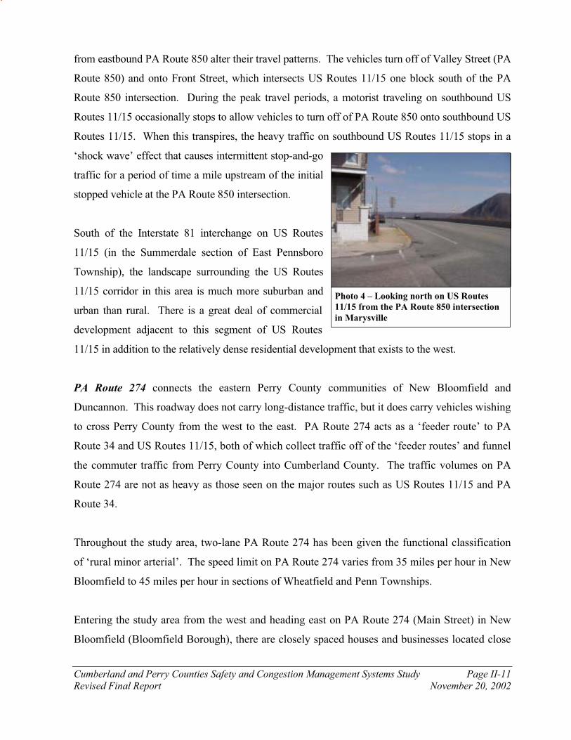
from eastbound PA Route 850 alter their travel patterns. The vehicles turn off of Valley Street (PA
Route 850) and onto Front Street, which intersects US Routes 11/15 one block south of the PA
Route 850 intersection. During the peak travel periods, a motorist traveling on southbound US
Routes 11/15 occasionally stops to allow vehicles to turn off of PA Route 850 onto southbound US
Routes 11/15. When this transpires, the heavy traffic on southbound US Routes 11/15 stops in a
‘shock wave’ effect that causes intermittent stop-and-go
traffic for a period of time a mile upstream of the initial
stopped vehicle at the PA Route 850 intersection.
South of the Interstate 81 interchange on US Routes
11/15 (in the Summerdale section of East Pennsboro
Township), the landscape surrounding the US Routes
11/15 corridor in this area is much more suburban and
urban than rural. There is a great deal of commercial
development adjacent to this segment of US Routes
11/15 in addition to the relatively dense residential development that exists to the west.
PA Route 274 connects the eastern Perry County communities of New Bloomfield and
Duncannon. This roadway does not carry long-distance traffic, but it does carry vehicles wishing
to cross Perry County from the west to the east. PA Route 274 acts as a ‘feeder route’ to PA
Route 34 and US Routes 11/15, both of which collect traffic off of the ‘feeder routes’ and funnel
the commuter traffic from Perry County into Cumberland County. The traffic volumes on PA
Route 274 are not as heavy as those seen on the major routes such as US Routes 11/15 and PA
Route 34.
Throughout the study area, two-lane PA Route 274 has been given the functional classification
of ‘rural minor arterial’. The speed limit on PA Route 274 varies from 35 miles per hour in New
Bloomfield to 45 miles per hour in sections of Wheatfield and Penn Townships.
Entering the study area from the west and heading east on PA Route 274 (Main Street) in New
Bloomfield (Bloomfield Borough), there are closely spaced houses and businesses located close

Cumberland and Perry Counties Safety and Congestion Management Systems Study Page II-12
Revised Final Report November 20, 2002
Photo 5 – Looking east on PA Route 274
approaching US Routes 11/15
to the roadway. Many driveways, local streets, and access roads intersect PA Route 274 within
New Bloomfield. South of New Bloomfield, the landscape transitions from medium-density
residential to low-density residential and rural in Centre Township. The adjacent land uses
consist of a mix of private homes and small farms with grazing cattle. Farther south, PA Route
274 eastbound departs PA Route 34 at Mecks Corner as it heads east into Wheatfield Township
and toward Duncannon. This junction (Mecks Corner) results in a confusing intersection
because Dellville Road traffic that is intending to travel north on PA Route 34 sometimes crosses
the path of motorists from the PA Route 274 west connector attempting to enter PA Route 34
southbound. This occurs because Dellville Road and the PA Route 274 west connector, which
are the two approaches controlled by a stop sign at this intersection, connect with PA Route 34
on the east side of the roadway.
East of the southern junction of PA Route 34 and PA
Route 274 at Mecks Corner, the countryside is
characterized by widely spaced single-family homes
with farmland/grazing land located between the homes.
Farther east, the traffic volumes on PA Route 274 tend
to increase because more vehicles are using the
roadway to get to US Routes 11/15 in Duncannon.
Near the Dellville Road intersection, a small shopping
center with a supermarket (Mutzbaugh Market) is located adjacent to PA Route 274. The traffic
associated with the supermarket accesses PA Route 274 via Business Campus One Driveway.
The intersection of PA Route 274 and the Business Campus One Driveway experiences high
traffic volumes and dangerous conditions during the morning and evening peak traffic periods.
Additional commercial/office development is also planned at Business Campus One in the near
future.
From this location, PA Route 274 heads east down the hill toward Duncannon and the US Routes
11/15 interchange. This section of PA Route 274, between Dellville Road (SR 2002) and US
Routes 11/15, currently experiences heavy traffic flows and dangerous conditions that are, in

Cumberland and Perry Counties Safety and Congestion Management Systems Study Page II-13
Revised Final Report November 20, 2002
part, caused by narrow shoulders and poor sight distance from the intersecting side roads and
driveways.
The traffic from Wheatfield Township and northern Penn Township that is fed onto PA Route
274 can access US Routes 11/15 and the Harrisburg metropolitan area via the US Routes 11/15 –
PA Route 274 interchange. The US Routes 11/15 bridge over PA Route 274 has a low clearance
height of 13’7”. According to the PENNDOT Design Manual Part 2, the minimum vertical
clearance height for structures crossing over the arterial and collector roadways is 14’6”. This
includes a six-inch allowance for future resurfacing of the roadway.
PA Route 850, west of PA Route 34, is an arterial roadway that serves traffic headed from
Loysville and Landisburg to PA Route 34 southbound and Cumberland County. Between PA
Route 34 and US Routes 11/15 (east of PA Route 34), PA Route 850 is a ‘feeder route’ that runs
east to west in the valley on the north side of Blue Mountain. PA Route 850 collects the local
traffic from the valley and feeds it onto either PA Route 34 or US Routes 11/15. Because a high
amount of commuter traffic uses PA Route 850, the directional distribution of the peak hour
traffic is unbalanced.
Depending on the section of roadway, PA Route 850 has been given different functional
classifications. The section of PA Route 850 that is west of PA Route 34 and the section of PA
Route 850 that is joined with PA Route 34 have been given the functional classification of ‘rural
minor arterial’. The ‘rural minor arterial’ sections of PA Route 850 carry more traffic than the
section of roadway that is east of PA Route 34. This section of PA Route 850 (east of PA Route
34) has been given the functional classification of ‘rural major collector’. In the borough of
Marysville, PA Route 850 has been given the functional classification of ‘urban minor arterial’
because of the urban surroundings and the higher amount of traffic that is carried on this section
of roadway. PA Route 850 is a two-lane roadway for its entire length within the study area. The
posted speed limit on PA Route 850 varies from 55 miles per hour in the rural sections in Rye
Township to 35 miles per hour in the urban sections within the borough of Marysville.
Cumberland and Perry Counties Safety and Congestion Management Systems Study Page II-14
Revised Final Report November 20, 2002
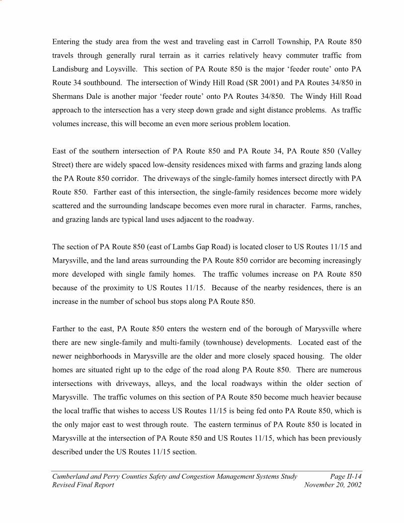
Entering the study area from the west and traveling east in Carroll Township, PA Route 850
travels through generally rural terrain as it carries relatively heavy commuter traffic from
Landisburg and Loysville. This section of PA Route 850 is the major ‘feeder route’ onto PA
Route 34 southbound. The intersection of Windy Hill Road (SR 2001) and PA Routes 34/850 in
Shermans Dale is another major ‘feeder route’ onto PA Routes 34/850. The Windy Hill Road
approach to the intersection has a very steep down grade and sight distance problems. As traffic
volumes increase, this will become an even more serious problem location.
East of the southern intersection of PA Route 850 and PA Route 34, PA Route 850 (Valley
Street) there are widely spaced low-density residences mixed with farms and grazing lands along
the PA Route 850 corridor. The driveways of the single-family homes intersect directly with PA
Route 850. Farther east of this intersection, the single-family residences become more widely
scattered and the surrounding landscape becomes even more rural in character. Farms, ranches,
and grazing lands are typical land uses adjacent to the roadway.
The section of PA Route 850 (east of Lambs Gap Road) is located closer to US Routes 11/15 and
Marysville, and the land areas surrounding the PA Route 850 corridor are becoming increasingly
more developed with single family homes. The traffic volumes increase on PA Route 850
because of the proximity to US Routes 11/15. Because of the nearby residences, there is an
increase in the number of school bus stops along PA Route 850.
Farther to the east, PA Route 850 enters the western end of the borough of Marysville where
there are new single-family and multi-family (townhouse) developments. Located east of the
newer neighborhoods in Marysville are the older and more closely spaced housing. The older
homes are situated right up to the edge of the road along PA Route 850. There are numerous
intersections with driveways, alleys, and the local roadways within the older section of
Marysville. The traffic volumes on this section of PA Route 850 become much heavier because
the local traffic that wishes to access US Routes 11/15 is being fed onto PA Route 850, which is
the only major east to west through route. The eastern terminus of PA Route 850 is located in
Marysville at the intersection of PA Route 850 and US Routes 11/15, which has been previously
described under the US Routes 11/15 section.

Cumberland and Perry Counties Safety and Congestion Management Systems Study Page II-15
Revised Final Report November 20, 2002
PA Route 849 is an east-west rural collector roadway that connects the borough of Newport to
Duncannon. The traffic volumes on the section of PA Route 849 between Newport and
Duncannon are very light because almost all of the traffic that travels between the boroughs uses
the much faster route of US Routes 22/322. Within the study area, PA Route 849 is a
meandering, hilly route with steep side slopes and sharp curves that carries mostly short-distance
and local traffic. Commuter traffic from the Borough of Duncannon is fed onto US Routes
22/322 at Clarks Ferry via PA Route 849.
PA Route 849 has been given the functional classifications of ‘rural minor collector’ north of
Newport and ‘rural major collector’ between Newport and its eastern terminus at US Routes
22/322. Throughout the study area, PA Route 849 is a two-lane roadway (one lane in each
direction) with severe horizontal and vertical curves. The posted speed limit on PA Route 849
varies from as low as 25 miles per hour in the built-up residential sections of Newport to as high
as 40 miles per hour in the rural sections of Miller, Wheatfield, and Penn Townships.
Entering the study area from the north and traveling toward the south, PA Route 849 enters the
study area within the borough of Newport where it is known as Fourth Street. The borough of
Newport is a densely developed town with many homes, and parking is available along the east
side of the street. There are many intersections with driveways, alleys, and local streets along
this section of PA Route 849.
Outside of Newport and south of its junction with PA Route 34, PA Route 849 enters into Miller
Township where the posted speed limit is 35 miles per hour. The section of PA Route 849 that is
in Miller Township has very sharp curves and extremely steep grades. Low-speed hairpin curves
and grades as steep as 14 percent make it very difficult for trucks to travel. The physical
geometry of the roadway allows for very lengthy travel times and slow rates of speed. These are
deterrents for through traffic in addition to being cost-prohibitive for commercial truck traffic.
As a result, the traffic volumes on the section of PA Route 849 between Newport and
Duncannon are very low. The surrounding landscape is very rural with a considerable amount of
forested land and a few widely spaced single-family homes.

Cumberland and Perry Counties Safety and Congestion Management Systems Study Page II-16
Revised Final Report November 20, 2002
East of its overpass crossing of US Routes 11/15, PA Route 849 intersects with Market Street,
which is immediately north of Duncannon. During times of high river levels, this section of PA
Route 849 is flooded out and closed to traffic. The facilities needed to pump out the water in the
Duncannon Subway currently exist and are not being used to mitigate the current flooding
situation. When flooded, US Routes 22/322 cannot be accessed from Duncannon via PA Route
849. The importance of maintaining this section of roadway is evident in the fact that the delays
and detours caused by the flooding are especially harmful to emergency vehicle access. This
section of PA Route 849 has higher amounts of traffic because it connects Duncannon to US
Routes 22/322. PENNDOT is planning on remedying this problem.
Just east of the ‘Duncannon Subway’, PA Route 849 crosses over the Juniata River, via the
Juniata River Bridge, and into Reed Township in Dauphin County. This bridge is a narrow
structure and is in deteriorating condition. Immediately east of the bridge over the Juniata River
is the eastern terminus of PA Route 849 at US Routes 22/322.
B. Existing Transit Service Information
Public transportation can play a role in rapidly growing areas such as Cumberland and Perry
Counties. The extent of the current transit system must be assessed so that possible
improvements or expansions in service can be suggested. For each corridor, the existing transit
service routes that currently provide service along the corridor are quantified, and the ridership
numbers (if available) are also given below.
In the study area, two types of transit services are available, fixed-route bus service and
paratransit service. The fixed route bus service is provided by Capital Area Transit (CAT),
which is the provider of public transit services to the Harrisburg metropolitan area. The
paratransit services are provided by the Cumberland County Transportation Department (in
Cumberland County) and by the Perry County Transportation Authority (in Perry County).
The transit service (provided by Capital Area Transit) provides transportation service along pre-
determined, scheduled, fixed routes for a fare (charged on a per use basis). Service is provided

Cumberland and Perry Counties Safety and Congestion Management Systems Study Page II-17
Revised Final Report November 20, 2002
on most routes during the day from Monday through Saturday, CAT does not operate buses on
Sundays and major holidays. The general public is charged the full fare, senior citizens (over 65
years old) ride free during off-peak hours, and handicapped persons (with proper identification)
ride for half price.
Utilized by fixed-route transit patrons and by carpooling motorists, the existing park and ride
facilities that are located within the study area are inventoried and described below. Information
on existing park and ride facilities has been gathered from the Tri-County Regional Planning
Commission.
The paratransit services in Cumberland and Perry Counties provide transportation (via
minibuses) for senior citizens, the mentally and developmentally disabled, the general public,
and transportation for medical appointments. In order to use the paratransit services, the patron
must call and make a reservation while also providing information such as the time and the
location that he or she wishes to be picked up and the location of their final destination. Often,
the reservations need to be made one or two days in advance of the actual trip. For the use of
this service, full fares (as high as $10.00) are charged to the general public, while senior citizens
and the handicapped pay a reduced fare (approximately $1.00), and some senior citizens qualify
for free rides. Paratransit service is available Monday through Friday from 8:00 AM to 4:00 PM.
The Cumberland County Transportation Department provides paratransit service throughout
Cumberland County, and paratransit service is provided throughout Perry County by the Perry
County Transportation Authority.
North of Newport on PA Route 34 and adjacent to the US Routes 22/322 interchange,
commuters form an unofficial carpool park and ride lot in the shopping center parking lot. This
carpool park and ride lot, which is used by people that live in the Newport area, has excellent
access to the Harrisburg area because it is located on PA Route 34 just south of the US Routes
22/322 interchange.
Only the eastern end of the PA Route 944 corridor in East Pennsboro and Hampden Townships
has access to fixed route transit service. The fixed route transit services are provided by Capital

Cumberland and Perry Counties Safety and Congestion Management Systems Study Page II-18
Revised Final Report November 20, 2002
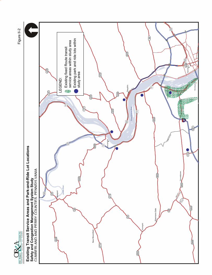
Area Transit (CAT). A map of the existing fixed route transit service areas is shown on Figure
II-2.
CAT Bus Route F travels from downtown Harrisburg via US Routes 11/15 into the study area
and onto PA Route 944 (State Street). Bus Route F continues on PA Route 944 onto South
Enola Drive, with bus stops located at the beginning of every block. PA Route 944 makes a left-
turn from South Enola Drive onto Wertzville Road, but CAT Bus Route F continues along Enola
Drive on its way to the park and ride lot in the Summerdale Shopping Center along US Routes
11/15. CAT Bus Route F uses the same roads (opposite direction) for the inbound bus route.
The CAT buses operate from 6:40 AM to 5:40 PM Monday through Friday. There are eight
scheduled buses each day per direction for a total of 16 scheduled buses (inbound and outbound).
There is no weekend service on this bus route. The average daily ridership on CAT Bus Route F
is 102 one-way trips per day (51 round trips). This is the total ridership for the entire route from
Enola to downtown Harrisburg.
Recently, CAT Bus Route F traveled farther north on US Routes 11/15 into Marysville, Perry
County. The fixed route bus service to Perry County was discontinued by CAT in March 2001
because of low ridership numbers. An average of only eight people per day made the round trip
from the Marysville park and ride lot into Harrisburg. The park and ride lot still exists at the
same location on the southbound side of US Routes 11/15 in Marysville. Commuters can still
use this location as a carpool park and ride lot.
CAT Bus Route K serves the Cumberland Technology Park and the Harrisburg Patriot-News
Distribution center at the intersection of PA Route 944 and Valley Road in Hampden Township.
The bus route travels northbound from Camp Hill on East Penn Drive and then turns left onto
Wertzville Road on its way to the Cumberland Technology Park at Valley Road. There are
currently only two scheduled buses per day in each direction for a total of four scheduled buses
(inbound and outbound). There is no weekend service on this bus route.

Cumberland and Perry Counties Safety and Congestion Management Systems Study Page II-19
Revised Final Report November 20, 2002
Photo 6 – Looking west at the park and
ride lot on PA Route 114 approaching
PA Route 944
An informal carpool park and ride lot exists along PA Route 114 between PA Route 944 and
Interstate 81 (see Photo 6). A number of commuters currently park in the gravel area off of the
westbound shoulder of PA Route 114 where they wait for their carpool to form. Fixed-route
transit service does not currently exist in the immediate vicinity.
Although there are no fixed route transit services nearby, a small number of commuters currently
utilize South Main Street near the PA Route 274 interchange with US Routes 11/15 as a carpool
park and ride location. The construction of a new official park-and-ride carpool lot at this
interchange is currently on the fourth of the four-year Transportation Improvement Program
(TIP).
During the construction of the Dauphin Narrows Bypass, Capital Area Transit (CAT) provided
for fixed-route service from Harrisburg to Halifax via US Routes 22/322. This route has since
been canceled because of low ridership numbers. There is currently no fixed route transit service
along the US Routes 22/322 corridor within the study
area. A carpool park and ride lot has been constructed
at the PA Route 225 interchange with the rebuilt US
Routes 22/322. This lot has the potential to be served
by a future fixed-route transit line. Motorists presently
use the paved parking area at the interchange of US
Routes 22/322 with PA Route 147 as an informal
carpool lot.
A map showing the locations of carpool park and ride lots within the study area is shown on
Figure II-2.
Ex
isti
ng
Tra
ns
it S
erv
ice
Are
as
an
d P
ark
-an
d-R
ide
Lo
t L
oc
ati
on
s
Sa
fety
an
d C
on
ge
sti
on
Ma
na
ge
men
t S
ys
tem
Stu
dy
CU
MB
ER
LA
ND
AN
DP
ER
RY
CO
UN
TIE
S,P
EN
NS
YLV
AN
IA
Fig
ure
II-
2
LE
GE
ND
:
Exis
tin
g fix
ed
Ro
ute
tra
nsit
se
rvic
e a
reas w
ith
in s
tud
y a
rea
E
xis
ting p
ark
and r
ide lots
within
stu
dy a
rea

Cumberland and Perry Counties Safety and Congestion Management Systems Study Page II-21
Revised Final Report November 20, 2002
C. Existing Traffic Volumes
Overview of Regional Traffic Conditions Peak hour traffic congestion occurs at several locations within the project study area during the
commute into and from the Harrisburg/Camp Hill/Mechanicsburg employment centers and
commercial areas. A map that shows the existing areas of congestion is shown on Figure II-3.
Primary congestion occurs as traffic flows accumulate from local roads and streets within the study
area to east-west cross-routes including PA Route 849, PA Route 274, PA Route 850, and from
points beyond the study area including Blain, Juniata County, Liverpool, and beyond. Traffic
accumulates to create morning peak hour backups on PA Route 34 from Sterretts Gap to Shermans
Dale, US Routes 11/15, and at some locations on PA Route 944.
Previously, severe traffic congestion and frequent backups have occurred on US Routes 22/322
from Dauphin to the Clarks Ferry Bridge and on US Routes 11/15 from Duncannon to Marysville.
These problem areas on US Routes 11/15 may have been remedied by the construction of the
Dauphin Narrows Bypass (US Routes 22/322), which is a four-lane limited-access expressway that
takes the through traffic off of the local two-lane roadway (old US Routes 22/322). The existing
traffic flows, which include a significant amount of heavy vehicle traffic, are relatively heavy and
steady on the section of US Routes 11/15 between Duncannon and Marysville. The travel times
experienced on the new four-lane US Routes 22/322 are greatly improved compared to those
experienced on the existing two-lane roadway of US Routes 22/322.
The truck traffic on US Routes 22/322 typically increases during the day to become a significant
portion of the traffic stream. North and west of Clark’s Ferry and the US Routes 11/15 - US
Routes 22/322 interchange, the through truck traffic is split between US Routes 11/15 and US
Routes 22/322.

Ex
isti
ng
Co
ng
es
ted
Are
as
Lo
ca
tio
n M
ap
S
afe
ty a
nd
Co
ng
esti
on
Ma
na
ge
men
t S
ys
tem
Stu
dy
CU
MB
ER
LA
ND
AN
DP
ER
RY
CO
UN
TIE
S,P
EN
NS
YLV
AN
IA
Fig
ure
II-
3
LE
GE
ND
:
Exis
tin
g c
onge
ste
d a
reas
(durin
g p
eak p
eriod
s)
Cumberland and Perry Counties Safety and Congestion Management Systems Study Page II-23
Revised Final Report November 20, 2002
Major destinations of vehicles originating in Perry County include the Harrisburg Government
centers of employment, which can be reached via Front Street in Harrisburg and US Routes 11/15
in Wormleysburg; the Camp Hill business complex via the same roads, and the recently completed
East Penn Drive (Center Street); and the commercial districts in Mechanicsburg along Gettysburg
Pike and Carlisle Pike via Interstate 81, PA Route 581, PA Route 114, and to a lesser extent Lambs
Gap Road. Access to the Carlisle Business District and industries also occurs by way of PA Route
34 from Perry County.
As traffic volumes and congestion on the major collectors/arterials (PA Route 34 and US Routes
11/15) increase, drivers begin to seek alternative routes with lower design speeds, reduced
capacity, and increased deficiencies. Alternative routes include Dellville Road, Pine Hill Road,
Mountain Road, Idle Road, Lambs Gap Road, and Tower Road in Rye Township and the
Overview Road and bridge in Marysville/Summerdale.
Key capacity reducing "bottlenecks" include: US Routes 11/15 at Marysville (a two-lane roadway
carrying greater than 22,000 Average Daily Traffic (ADT) squeezed between Blue Ridge
Mountain, Norfolk Southern Rail lines and the Susquehanna River), and PA Route 34, which
funnels greater than 17,000 vehicles per day from Central Perry County (a rapidly growing area)
through Sterretts Gap (a section of steep mountainous roadway with several high-conflict
intersections) and access points.
Prior to the completion of the Dauphin Narrows Bypass (US Routes 22/322), the return (evening)
commute from the previously identified points of destination (Harrisburg, Camp Hill,
Mechanicsburg, Carlisle) typically deteriorated from east to west with vehicle stacking beginning
at US Routes 22/322 in Dauphin. Congestion then followed on the west side of the river at US
Routes 11/15 at the end of the mountain in Marysville. PA Route 34 also experiences congestion
as many commuters make their way through Sterretts Gap into Perry County. As traffic at these
points of egress accumulates, alternative secondary roads experience increased traffic volumes and
flows which conflict with local residential traffic.

Cumberland and Perry Counties Safety and Congestion Management Systems Study Page II-24
Revised Final Report November 20, 2002
Now that the Dauphin Narrows Bypass is complete, the extreme traffic congestion on US Routes
22/322 has disappeared, and the severe backups that were experienced on US Routes 11/15 have
transformed in to a moderately heavy, but steady stream of traffic with occasional stop and go
traffic during peak travel periods. Today, PA Route 34 in the vicinity of Sterretts Gap still
experiences the heavy congestion and long backups that are present during the morning and
evening peak periods.
The volume of out-of-state traffic through the project study area builds to a peak throughout the
week and is greatest during the Friday evening peak period as Marylanders and Virginians cross
through the area to weekend vacation sites in north-central, central, and west-central Pennsylvania.
Their return trip back through the study area is marked by very heavy traffic volumes on US Route
322 and US Routes 11/15 on Sunday afternoons. New Yorkers vacationing in central
Pennsylvania visiting area tourist attractions in Gettysburg, Hershey, and Lancaster are also
included with the through traffic that contribute to the vehicle mix of local and through traffic on
the major study area roadways.
Existing Traffic Volumes In order to adequately assess the existing transportation conditions of the roadways within the
study area, the existing traffic volumes on the major roadways must be quantified. The existing
traffic volume data within the study area was collected in two manners: manual intersection
counts and automatic traffic recorder counts.
The manual turning movement traffic counts were performed at key intersections along the
major roadways within the study area. Table II-1 shows the locations of the intersections that
were manually counted.
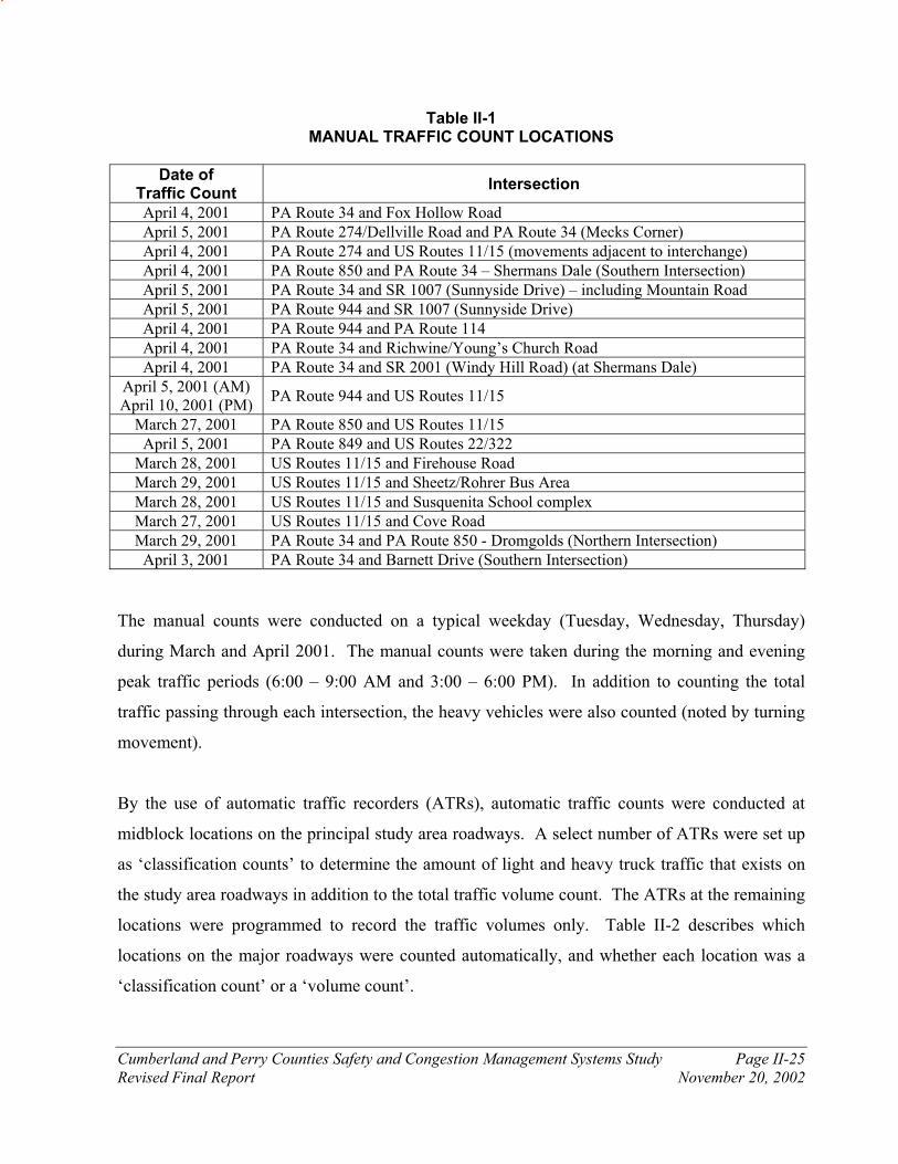
Cumberland and Perry Counties Safety and Congestion Management Systems Study Page II-25
Revised Final Report November 20, 2002
Table II-1 MANUAL TRAFFIC COUNT LOCATIONS
Date of Traffic Count
Intersection
April 4, 2001 PA Route 34 and Fox Hollow Road
April 5, 2001 PA Route 274/Dellville Road and PA Route 34 (Mecks Corner)
April 4, 2001 PA Route 274 and US Routes 11/15 (movements adjacent to interchange)
April 4, 2001 PA Route 850 and PA Route 34 – Shermans Dale (Southern Intersection)
April 5, 2001 PA Route 34 and SR 1007 (Sunnyside Drive) – including Mountain Road
April 5, 2001 PA Route 944 and SR 1007 (Sunnyside Drive)
April 4, 2001 PA Route 944 and PA Route 114
April 4, 2001 PA Route 34 and Richwine/Young’s Church Road
April 4, 2001 PA Route 34 and SR 2001 (Windy Hill Road) (at Shermans Dale)
April 5, 2001 (AM) April 10, 2001 (PM)
PA Route 944 and US Routes 11/15
March 27, 2001 PA Route 850 and US Routes 11/15
April 5, 2001 PA Route 849 and US Routes 22/322
March 28, 2001 US Routes 11/15 and Firehouse Road
March 29, 2001 US Routes 11/15 and Sheetz/Rohrer Bus Area
March 28, 2001 US Routes 11/15 and Susquenita School complex
March 27, 2001 US Routes 11/15 and Cove Road
March 29, 2001 PA Route 34 and PA Route 850 - Dromgolds (Northern Intersection)
April 3, 2001 PA Route 34 and Barnett Drive (Southern Intersection)
The manual counts were conducted on a typical weekday (Tuesday, Wednesday, Thursday)
during March and April 2001. The manual counts were taken during the morning and evening
peak traffic periods (6:00 – 9:00 AM and 3:00 – 6:00 PM). In addition to counting the total
traffic passing through each intersection, the heavy vehicles were also counted (noted by turning
movement).
By the use of automatic traffic recorders (ATRs), automatic traffic counts were conducted at
midblock locations on the principal study area roadways. A select number of ATRs were set up
as ‘classification counts’ to determine the amount of light and heavy truck traffic that exists on
the study area roadways in addition to the total traffic volume count. The ATRs at the remaining
locations were programmed to record the traffic volumes only. Table II-2 describes which
locations on the major roadways were counted automatically, and whether each location was a
‘classification count’ or a ‘volume count’.

Cumberland and Perry Counties Safety and Congestion Management Systems Study Page II-26
Revised Final Report November 20, 2002
In order to obtain average daily traffic volumes, all ATR counts were conducted for 24 hours a
day for a period of one complete week. The automatic traffic counts were conducted during
between Monday, March 26, 2001, and Monday, April 9, 2001.
Table II-2
AUTOMATIC TRAFFIC COUNT LOCATIONS
Roadway Location Type of Traffic
Count
US Routes 22/322 Between PA Route 325 and PA Route 225 Classification
US Routes 22/322 Between PA Route 849 and US Routes 11/15 Volume
US Routes 11/15 All eight (8) interchange ramps with US Routes 22/322 Classification
US Routes 11/15 All 8 interchange ramps with Interstate 81 Classification
US Routes 11/15 Between PA Route 850 and PA Route 274 Classification
US Routes 11/15 South of PA Route 944 Classification
PA Route 34 South of Sterretts Gap (Sunnyside Drive – SR 1007) Volume
PA Route 944 West of Sunnyside Drive – SR 1007 Volume
PA Route 944 Between Sunnyside Drive and PA Route 114 Volume
PA Route 944 East of PA Route 114 Volume
PA Route 944 Between Interstate 81 and Center Street Classification
PA Route 850 West of PA Route 34 Volume
PA Route 850 East of Lambs Gap Road Volume
PA Route 274 West of PA Route 34 Volume
PA Route 274 West of US Routes 11/15 Volume
PA Route 849 West of US Routes 22/322 Volume
Lambs Gap Rd Between PA Route 944 and PA Route 850 Volume
Carlisle Cutoff Between PA Route 34 and PA Route 944 Volume
US Routes 22/322 West of PA Route 34 Volume
Figure II-4, Figure II-5, and Figure II-6 summarize the existing average daily traffic volumes, the
morning peak hour traffic volumes, and the evening peak hour traffic volumes for select roadway
segments within the study area.


Cumberland and Perry Counties Safety and Congestion Management Systems Study Page II-30
Revised Final Report November 20, 2002
In general, the existing traffic data shows that the morning peak hour traffic volumes are
marginally less than the evening peak hour traffic volumes. The intersections and roadways
nearest to Harrisburg and Interstate 81 exhibit the highest daily and peak hour traffic volumes.
Generally, whatever traffic is headed eastbound (or southbound) during the morning returns by
traveling westbound (or northbound) during the evening; this is evidence of the many commuters
that reside in Perry County and work in Cumberland and Dauphin Counties.
D. Existing Levels of Service
Overview of Capacity Analysis Procedures While existing traffic volumes provide an important measure of activity on the study area
roadway system, evaluating how well the system accommodates those volumes is also very
important. A comparison of the peak hour traffic volumes to the constraints of the existing
roadway geometry, environment, traffic characteristics, and controls is a very good way to gain
an understanding of the capacity of a traffic system. In general, rural roadways and intersections
are designed to attain a Level of Service ‘C’, and urban roadways and intersections are designed
to attain a Level of Service ‘D’.
Intersections generally control capacity in road networks because most conflicts exist at these
points between through, crossing, and turning vehicles. Because of these conflicts, congestion is
most likely to occur at intersections. Therefore, intersections are studied most often when
determining the quality of traffic flow on a road network.
An unsignalized intersection on a through route is seldom critical from an overall capacity
standpoint. However, it may be of great significance to the capacity of the minor cross route and
it may influence the level of service on both. In analyzing two-way stop-controlled unsignalized
intersections, it is assumed that the through movement on the major street and the right turns
from the major street are unimpeded and have the right-of-way over all side street traffic and left
turns from the major street. All other movements through the intersection either cross, merge
with, or are affected by other flows. A descriptive mechanism (Level of Service) has been
developed for unsignalized intersections which indicates the average delay at the intersection on

Cumberland and Perry Counties Safety and Congestion Management Systems Study Page II-31
Revised Final Report November 20, 2002
a scale from ‘a’, indicating an average delay between 0 and 10 seconds, to ‘f’ indicating an
average delay greater then 50 seconds. Table II-3 summarizes the unsignalized intersection level
of service criteria.
Table II-3
LEVEL OF SERVICE AND EXPECTED DELAY FOR UNSIGNALIZED INTERSECTIONS1
Level of Service Expected Traffic Delay Average Total Delay
(seconds per vehicle)
a Little or no delay 0.0 to 10.0
b Short traffic delays 10.1 to 15.0
c Average traffic delays 15.1 to 25.0
d Long traffic delays 25.1 to 35.0
e Long traffic delays 35.1 to 50.0
f Very long traffic delays greater than 50.0
At signalized intersections, such as the intersection of PA Route 944 and PA Route 114, factors
that affect the various approach capacities include the width of the lanes of the approach, the
number of lanes, the signal ‘green time’, the turning volumes, the truck percentages, etc. The
traffic conditions at the signalized intersections are measured by Level of Service (LOS), where
Level of Service ‘A’ is the best (less than ten seconds of delay), and Level of Service ‘F’ is the
worst (greater than 80 seconds of delay). However, operation at maximum capacity can be less
than satisfactory since substantial delays or reduced operating speeds are likely. Delays cannot
be related to capacity in a simple one-to-one fashion. It is possible to have delays in the Level of
Service ‘F’ range without exceeding roadway capacity. Substantial delays can exist without
exceeding capacity if one or more of the following conditions exist:
¶ Long signal cycle lengths
¶ A particular traffic movement experiences a long red time
¶ Progressive movement for a particular lane group is poor
Table II-4 shows the level of service criteria and the associated delays for signalized
intersections. All computer analyses for the signalized and unsignalized intersections were
1 Transportation Research Board, Special Report 209, Highway Capacity Manual, Third Edition, published by the Transportation Research Board, Washington, D.C., 1998.

Cumberland and Perry Counties Safety and Congestion Management Systems Study Page II-32
Revised Final Report November 20, 2002
performed using the most recent version of the Federal Highway Administration’s Highway
Capacity Software (HCS).
Table II-4 LEVEL OF SERVICE AND EXPECTED DELAY FOR
SIGNALIZED INTERSECTIONS2
Level of Service
Description Average Total Delay
(seconds per vehicles)
A Very low delay, very good progression; most vehicles do not stop at intersection
0.0 to 10.0
B Generally good signal progression and/or short cycle length; more vehicles stop at intersection than Level of Service ‘A’
10.1 to 20.0
C Fair progression and/or longer cycle length; significant number of vehicles stop at intersection
20.1 to 35.0
D
Congestion becomes more noticeable; individual cycle failures; longer delays from unfavorable progression, long cycle length, or high volume/capacity ratio; most vehicles stop at intersection
35.1 to 55.0
E
Usually considered limit of acceptable delay, high delay values are indicative of poor progression, long cycle length, or high volume/capacity ratio; frequent individual cycle failures
55.1 to 80.0
F
Could be considered excessive delay in some areas, frequently an indication of oversaturation (i.e. arrival flow exceeds capacity), or very long cycle lengths with minimal side street green time. Capacity is not necessarily exceeded under this level of service
greater than 80.0
In addition to the level of service analysis at the signalized and unsignalized intersections, the
operating conditions within certain segments (mid-blocks) of the major study area roadways
were also analyzed by the most recent version of HCS. The analyzed roadway segments in the
reported within this document are at those locations that exhibited the greatest peak hour traffic
volumes.
2 Transportation Research Board, Special Report 209, Highway Capacity Manual, Third Edition, published by the
Transportation Research Board, Washington, D.C., 1998.
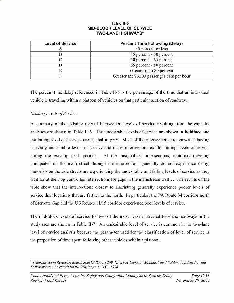
Cumberland and Perry Counties Safety and Congestion Management Systems Study Page II-33
Revised Final Report November 20, 2002
Table II-5 MID-BLOCK LEVEL OF SERVICE
TWO-LANE HIGHWAYS3
Level of Service Percent Time Following (Delay)
A 35 percent or less
B 35 percent - 50 percent
C 50 percent - 65 percent
D 65 percent - 80 percent
E Greater than 80 percent
F Greater then 3200 passenger cars per hour
The percent time delay referenced in Table II-5 is the percentage of the time that an individual
vehicle is traveling within a platoon of vehicles on that particular section of roadway.
Existing Levels of Service A summary of the existing overall intersection levels of service resulting from the capacity
analyses are shown in Table II-6. The undesirable levels of service are shown in boldface and
the failing levels of service are shaded in gray. Most of the intersections are shown as having
currently undesirable levels of service and many intersections exhibit failing levels of service
during the existing peak periods. At the unsignalized intersections, motorists traveling
unimpeded on the main street through the intersections generally do not experience delay;
motorists on the side streets are experiencing the undesirable and failing levels of service as they
wait for at the stop-controlled intersections for gaps in the mainstream traffic. The results on the
table show that the intersections closest to Harrisburg generally experience poorer levels of
service than locations that are farther to the north. In particular, the PA Route 34 corridor north
of Sterretts Gap and the US Routes 11/15 corridor experience poor levels of service.
The mid-block levels of service for two of the most heavily traveled two-lane roadways in the
study area are shown in Table II-7. An undesirable level of service is common in the two-lane
level of service analysis because the parameter used for the classification of level of service is
the proportion of time spent following other vehicles within a platoon.
3 Transportation Research Board, Special Report 209, Highway Capacity Manual, Third Edition, published by the Transportation Research Board, Washington, D.C., 1998.
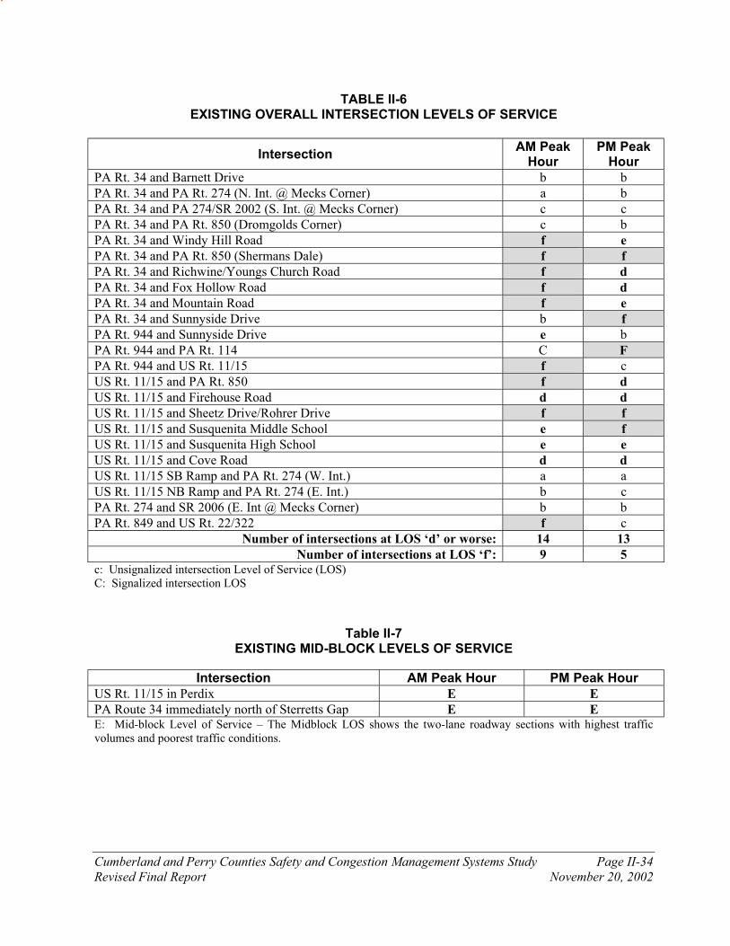
Cumberland and Perry Counties Safety and Congestion Management Systems Study Page II-34
Revised Final Report November 20, 2002
TABLE II-6 EXISTING OVERALL INTERSECTION LEVELS OF SERVICE
Intersection AM Peak
Hour PM Peak
Hour
PA Rt. 34 and Barnett Drive b b
PA Rt. 34 and PA Rt. 274 (N. Int. @ Mecks Corner) a b
PA Rt. 34 and PA 274/SR 2002 (S. Int. @ Mecks Corner) c c
PA Rt. 34 and PA Rt. 850 (Dromgolds Corner) c b
PA Rt. 34 and Windy Hill Road f e
PA Rt. 34 and PA Rt. 850 (Shermans Dale) f f
PA Rt. 34 and Richwine/Youngs Church Road f d
PA Rt. 34 and Fox Hollow Road f d
PA Rt. 34 and Mountain Road f e
PA Rt. 34 and Sunnyside Drive b f
PA Rt. 944 and Sunnyside Drive e b
PA Rt. 944 and PA Rt. 114 C F
PA Rt. 944 and US Rt. 11/15 f c
US Rt. 11/15 and PA Rt. 850 f d
US Rt. 11/15 and Firehouse Road d d
US Rt. 11/15 and Sheetz Drive/Rohrer Drive f f
US Rt. 11/15 and Susquenita Middle School e f
US Rt. 11/15 and Susquenita High School e e
US Rt. 11/15 and Cove Road d d
US Rt. 11/15 SB Ramp and PA Rt. 274 (W. Int.) a a
US Rt. 11/15 NB Ramp and PA Rt. 274 (E. Int.) b c
PA Rt. 274 and SR 2006 (E. Int @ Mecks Corner) b b
PA Rt. 849 and US Rt. 22/322 f c
Number of intersections at LOS ‘d’ or worse: 14 13
Number of intersections at LOS ‘f’: 9 5 c: Unsignalized intersection Level of Service (LOS) C: Signalized intersection LOS
Table II-7
EXISTING MID-BLOCK LEVELS OF SERVICE
Intersection AM Peak Hour PM Peak Hour
US Rt. 11/15 in Perdix E E
PA Route 34 immediately north of Sterretts Gap E E E: Mid-block Level of Service – The Midblock LOS shows the two-lane roadway sections with highest traffic volumes and poorest traffic conditions.
Cumberland and Perry Counties Safety and Congestion Management Systems Study Page II-35
Revised Final Report November 20, 2002
E. Crash Analysis
Overview of Crash Analysis Procedures From its Crash Record System, PENNDOT has provided crash data for the study area state-
maintained roadways for a five-year period (from January 1, 1995 through December 31, 1999).
A database of the crash records received from PENNDOT for the five-year period was
established. The crash database for each corridor provides the ability to extract cross-tabulations
of crashes sorted by location, type, frequency, causation factor, etc.
Within this document, the current crash rates for each study area roadway corridor are compared
to those crash rates experienced on similar highways across the state. The comparison of the
crash rates on similar roadways is useful in determining the relative overall safety of each
roadway corridor. The statewide average crash rate, which is expressed in crashes per million
vehicle miles traveled, takes into consideration the average amount of traffic that travels on that
roadway and the number of crashes that occur on that roadway. Dangerous segments of roadway
can be identified and comparisons can be made between roadways of similar characteristics and
functional classifications by using the statewide average crash rate as a benchmark. Figures and
tables included within this report show the actual crash rate for the segments of the roadway
corridor compared to the statewide average crash rate for that particular type of roadway.
The main goal of the crash analysis is not limited only to identifying the number of crashes, the
statewide rate comparisons, and the causation factors; the most important intent of the crash
analysis is to determine why the crashes are occurring. The locations of crash clusters are
examined and compared to the roadway deficiencies to determine if there might be a link. The
type of access control, the vehicle mix, conflicts between through and local traffic, a specific
roadway condition, or weather condition are all possible critical elements of a crash if a cause
and effect relationship is developed. With the cross-tabulations of the crash database, a cause
and effect relationship can be determined.
It should be noted that the Pennsylvania Department of Transportation defines crashes as those
that involve a fatality, injury, or require towing of one or more vehicles. Therefore, the Crash
Record System includes data from those “reportable” incidents. Analysis of this data showed

Cumberland and Perry Counties Safety and Congestion Management Systems Study Page II-36
Revised Final Report November 20, 2002
2,580 reported motor vehicle crashes on the study area roadways within the five-year analysis
period. All reportable crashes were examined in order to identify those locations with multiple
crashes. The non-reportable crashes that have occurred within the study area are summarized in
a later section of this chapter for locations where non-reportable crash data is available.
Tables II-8 through II-15 summarize the crash rate comparisons for each of the study area
roadway corridors: PA Route 34, PA Route 944, US Routes 11/15, PA Route 274, PA Route
850, PA Route 849, Interstate 81, US Routes 22/322.
The relative average crash rates and the crash cluster locations are graphically shown for each of
the above-mentioned study corridors on Figures II-7 through II-14. Not surprisingly, all of the
major crash clusters are located at intersections because of the fact that intersections are the
locations that experience conflicting traffic patterns more frequently than mid-block and merging
locations.
Table II-8 PA ROUTE 34
CRASH RATE COMPARISON
Length (miles) Crash Rate (Crashes/MVM)
Segment Total Over
Statewide Crash Rate
Statewide Average
Observed Percent
Difference
Study area boundary to Sunnyside Drive (SR 1007)
3.26 1.45 1.53 1.76 15 percent
Sunnyside Drive (SR1007) to Dromgold (PA Route 850)
5.12 2.54 1.05 1.45 38 percent
Dromgold (PA Route 850) to Mecks Corner (PA Route 274)
3.99 2.06 1.53 1.90 24 percent
Mecks Corner (PA Route 274) to New Bloomfield
3.39 3.39 1.53 6.47 323 percent
New Bloomfield to Northern study boundary
8.23 3.86 1.51 1.69 12 percent
Total 23.99 13.30 1.42 1.74 23 percent Note: Percent difference (observed rate/statewide rate)

Cumberland and Perry Counties Safety and Congestion Management Systems Study Page II-37
Revised Final Report November 20, 2002
Table II-9 PA ROUTE 944
CRASH RATE COMPARISON
Length (miles) Crash Rate (Crashes/MVM)
Segment Total Over
Statewide Crash Rate
Statewide Average
Observed Percent
Difference
Study Area Boundary to PA Route 34
0.51 0.51 1.53 1.82 19 percent
PA Route 34 North to Sunnyside Drive (SR1007)
3.22 0.97 1.53 1.48 -3 percent
Sunnyside Drive (SR1007) to PA Route 114
3.36 1.63 1.05 1.12 6 percent
PA Route 114 to Interstate 81
3.88 2.46 1.16 1.83 59 percent
Interstate 81 to US Routes 11/15
3.95 0.79 2.12 1.42 -33 percent
Total 14.92 6.36 1.48 1.39 -6 percent Note: Percent difference (observed rate/statewide rate)
Table II-10 US ROUTES 11/15
CRASH RATE COMPARISON
Length (miles) Crash Rate (Crashes/MVM)
Segment Total Over
Statewide Crash Rate
Statewide Average
Observed Percent
Difference
Study area boundary to Cumberland/Perry Border
4.00 0.27 2.14 0.85 -60 percent
Cumberland/Perry Border to Perdix (Woodland Drive)
3.18 0.97 1.57 0.42 -73 percent
Perdix (Woodland Drive) to Duncannon (PA Route 274)
6.02 5.21 0.29 0.85 194 percent
Duncannon (PA Route 274) to US Routes 322/22
2.31 2.14 0.29 0.51 76 percent
US Routes 322/22 to Northern study boundary
1.09 1.09 0.29 0.81 180 percent
Total 16.60 9.68 0.98 0.71 -27 percent Note: Percent difference (observed rate/statewide rate)
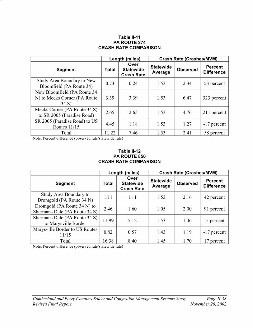
Cumberland and Perry Counties Safety and Congestion Management Systems Study Page II-38
Revised Final Report November 20, 2002
Table II-11 PA ROUTE 274
CRASH RATE COMPARISON
Length (miles) Crash Rate (Crashes/MVM)
Segment Total Over
Statewide Crash Rate
Statewide Average
Observed Percent
Difference
Study Area Boundary to New Bloomfield (PA Route 34)
0.73 0.24 1.53 2.34 53 percent
New Bloomfield (PA Route 34 N) to Mecks Corner (PA Route
34 S) 3.39 3.39 1.53 6.47 323 percent
Mecks Corner (PA Route 34 S) to SR 2005 (Paradise Road)
2.65 2.65 1.53 4.76 211 percent
SR 2005 (Paradise Road) to US Routes 11/15
4.45 1.18 1.53 1.27 -17 percent
Total 11.22 7.46 1.53 2.41 58 percent Note: Percent difference (observed rate/statewide rate)
Table II-12 PA ROUTE 850
CRASH RATE COMPARISON
Length (miles) Crash Rate (Crashes/MVM)
Segment Total Over
Statewide Crash Rate
Statewide Average
Observed Percent
Difference
Study Area Boundary to Dromgold (PA Route 34 N)
1.11 1.11 1.53 2.16 42 percent
Dromgold (PA Route 34 N) to Shermans Dale (PA Route 34 S)
2.46 1.60 1.05 2.00 91 percent
Shermans Dale (PA Route 34 S) to Marysville Border
11.99 5.12 1.53 1.46 -5 percent
Marysville Border to US Routes 11/15
0.82 0.57 1.43 1.19 -17 percent
Total 16.38 8.40 1.45 1.70 17 percent Note: Percent difference (observed rate/statewide rate)

Cumberland and Perry Counties Safety and Congestion Management Systems Study Page II-39
Revised Final Report November 20, 2002
Table II-13
PA ROUTE 849 CRASH RATE COMPARISON
Length (miles) Crash Rate (Crashes/MVM)
Segment Total Over
Statewide Crash Rate
Statewide Average
Observed Percent
Difference
Study Area Boundary to PA Route 34 N intersection (in
Newport) 0.92 0.43 1.53 1.71 12 percent
Newport (PA Route 34 N) to PA Route 34 S intersection
(PA Routes 34/849) 0.60 0.00 1.53 1.03 -33 percent
PA Route 34 S Intersection (PA Routes 34/849) to US
Routes 11/15 Overpass 8.76 4.33 1.53 1.82 19 percent
US Routes 11/15 overpass to US Routes 22/322
1.67 1.22 1.53 4.85 217 percent
Total 11.95 5.98 1.53 2.06 34 percent Note: Percent difference (observed rate/statewide rate)
Table II-14 INTERSTATE 81
CRASH RATE COMPARISON
Length (miles) Crash Rate (Crashes/MVM)
Segment Total Over
Statewide Crash Rate
Statewide Average
Observed Percent
Difference
West of PA Route 114 0.47 0.00 0.29 0.24 -16 percent
PA Route 114 to PA Route 581 3.04 2.05 0.29 0.40 38 percent
PA Route 581 to PA Route 944 1.00 1.00 0.29 0.39 34 percent
PA Route 944 to US Routes 11/15
3.99 0.00 0.55 0.23 -58 percent
US Routes 11/15 to North Front Street
0.55 0.00 0.55 0.55 0 percent
North Front Street to US Routes 322/22
2.09 0.98 0.55 0.49 -10 percent
East of US Routes 22/322 1.51 0.00 0.55 0.25 -53 percent
Total 12.65 4.03 0.46 0.35 -25 percent Note: Percent difference (observed rate/statewide rate)
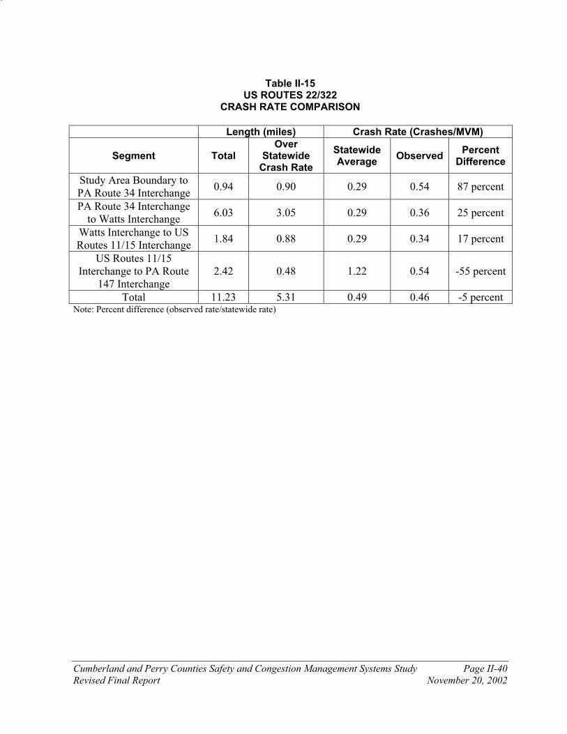
Cumberland and Perry Counties Safety and Congestion Management Systems Study Page II-40
Revised Final Report November 20, 2002
Table II-15 US ROUTES 22/322
CRASH RATE COMPARISON
Length (miles) Crash Rate (Crashes/MVM)
Segment Total Over
Statewide Crash Rate
Statewide Average
Observed Percent
Difference
Study Area Boundary to PA Route 34 Interchange
0.94 0.90 0.29 0.54 87 percent
PA Route 34 Interchange to Watts Interchange
6.03 3.05 0.29 0.36 25 percent
Watts Interchange to US Routes 11/15 Interchange
1.84 0.88 0.29 0.34 17 percent
US Routes 11/15 Interchange to PA Route
147 Interchange 2.42 0.48 1.22 0.54 -55 percent
Total 11.23 5.31 0.49 0.46 -5 percent Note: Percent difference (observed rate/statewide rate)
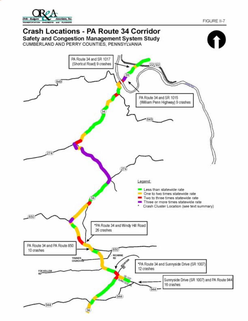
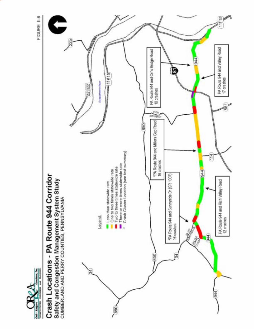


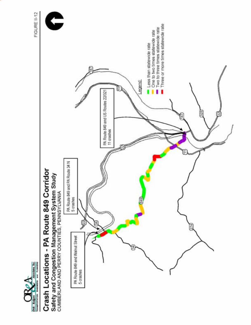
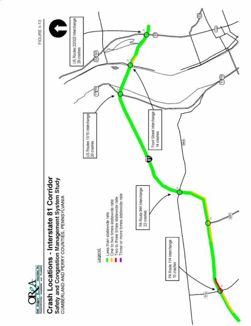


Cumberland and Perry Counties Safety and Congestion Management Systems Study Page II-49
Revised Final Report November 20, 2002
The following paragraphs detail the five crash cluster locations with the greatest amount of
reportable crashes in the study area.
¶ US Routes 11/15 and Valley Road (SR 1004)
(33 crashes)
This is a T-intersection controlled via a traffic signal. Sixteen (48 percent) of the 33 crashes
were angle collisions, eleven (33 percent) crashes were rear end collisions; and the remaining
six crashes (19 percent) were vehicles colliding with a fixed object. The angle collisions
occurred because of pulling out too soon and failure to stop at the red light. The rear end
collisions were due to tailgating and failure to heed a stopped driver. The crashes involving a
fixed object were due to a variety of reasons.
¶ PA Route 34 and Windy Hill Road (SR 2001)
(26 crashes)
This is a T-intersection controlled via a stop sign on Windy Hill Road. As previously noted,
the Windy Hill Road approach to the intersection has a very steep down grade and sight
distance problems. Eleven (42 percent) of the 26 crashes are rear end collisions, eight (31
percent) crashes are angle collisions; and the remaining seven crashes (27 percent) were
vehicles colliding with a fixed object. The rear end collisions were due to tailgating and
failure to heed a stopped driver. The angle collisions occurred because of pulling out too
soon and failure to stop. The crashes involving a fixed object were due to a variety of
reasons.
¶ PA Route 944 and Sunnyside Drive (SR1007)
(16 crashes)
This is a four-legged intersection located on the western end of PA Route 944. Of the 16
crashes that occurred here 10 crashes (62 percent) were angle crashes and can be attributed to
improper turning and pulling out too soon. Three crashes (19 percent) were rear end
collisions; tailgating and speeding are the primary causation factors for these crashes.
Speeding, abrupt lane changes and drunk driving were the factors causing the remaining

Cumberland and Perry Counties Safety and Congestion Management Systems Study Page II-50
Revised Final Report November 20, 2002
three (19 percent) fixed object collisions. It should be noted that this intersection has
recently been reconfigured and reconstructed.
¶ PA Route 944 (Wertzville Road) and Millers Gap Road (T594)/Willow Mill Road (T717)
(16 crashes)
This intersection is located just east of PA Route 114. Thirteen crashes (81 percent) at this
location were angle collisions due to drivers pulling out too soon and not properly turning.
The remaining crashes were rear end collisions (2 crashes, 13 percent) and hitting a fixed
object (1 crash, 6 percent). The rear end collisions were due to tailgating and the weather;
the fixed object collision was due to driver distraction (tape/radio). An angle collision at this
intersection was due to driver drinking.
¶ PA Route 34 and Sunnyside Drive (SR 1007) / Mountain Road
(12 crashes)
This is a four-legged stop sign controlled intersection located at Sterretts Gap on the border
between Cumberland County and Perry County. Both of the minor streets, Sunnyside Drive
and Mountain Road, are each controlled by a stop sign and connect with PA Route 34 on the
same (east) side of the roadway. Five (42 percent) of the 12 crashes were angle collisions,
three (25 percent) were rear end collisions, and the remaining four (33 percent) involved
vehicles hitting a fixed object, a sideswipe collision, and a non-collision incident. Two of the
angle collisions were due to drunk drivers turning improperly and pulling out into the
roadway too soon. The remaining three angle collisions were also caused by improper
turning and pulling out too soon. The three rear end collisions were caused by failing to heed
a stopped vehicle, tailgating, and other distractions. One vehicle hit a fixed object because of
a deer in the roadway and the other fixed object collision was caused by an out of control
vehicle. The sideswipe collision was caused by an attempted pass in a no passing zone. The
non-collision incident was due to engine failure.
Non-reportable Crashes
Many crashes that occur within the study area are non-reportable crashes and are not entered into
the Department’s crash record database. In the more congested areas, such as the two-lane

Cumberland and Perry Counties Safety and Congestion Management Systems Study Page II-51
Revised Final Report November 20, 2002
section of US Routes 11/15, vehicles are traveling closer together at slower speeds and crashes
tend to be “fender benders” and non-reportable. To collect data on “non-reportable” crashes, the
local municipalities, fire companies, EMS, and State Police have been contacted numerous times.
All available non-reportable crash data have been collected. However, this may not be a
complete set of data because many non-reportable crashes are undocumented being that the
emergency response agencies (Fire, Police, EMS) do not respond to non-reportable crashes
(because non-reportable crashes do not involve an emergency or a serious injury). Also, the
State Police does not keep records of non-reportable crashes. Most of the non-reportable crash
data that has been collected does not contain all of the specifics (such as causation factors,
weather conditions, location, etc.) that are included in the reportable crash data that has been
provided by PENNDOT. Nonetheless, the cluster areas of the non-reportable crashes have been
noted, and locations where the non-reportable crash data is available are referenced below.
In Middlesex Township, 14 non-reportable crashes on PA Route 944 were recorded by the
Middlesex Township Police Department between November 1998 and April 2001. Three of the
14 non-reportable crashes occurred at the Deer Lane intersection. Between January 1999 and
September 2001, 26 non-reportable crashes on PA Route 944 were documented by the Silver
Spring Township Police Department, with six of the crashes located at the PA Route 114
intersection and five crashes located at the Rich Valley Road intersection. Ten non-reportable
crashes on PA Route 944 were recorded by the East Pennsboro Township Police Department
from January 1997 until September 2001. Two of the ten non-reportable crashes occurred at the
Magaro Road intersection with PA Route 944.
In East Pennsboro Township, 121 non-reportable crashes were recorded by the East Pennsboro
Township Police Department from January 1997 until September 2001 on US Routes 11/15.
The location for the majority of these non-reportable crashes is reported as ‘unknown’, but 30 of
the 121 crashes were known to occur at the Valley Street intersection with US Routes 11/15.
Many non-reportable crashes are known to occur at this signalized intersection because of the
combination of the downgrade on the southbound approach, the traffic signal, and the poor
pavement conditions that are present during inclement weather. On the two and three-lane
sections of US Routes 11/15 in Marysville and Penn Township, many non-reportable crashes are

Cumberland and Perry Counties Safety and Congestion Management Systems Study Page II-52
Revised Final Report November 20, 2002
known to occur because of the “fender benders” that are commonplace in the presence of
congested conditions and stop-and-go traffic.
F. Demographic and Land Use Summary
Population Trends
The study area has seen significant growth in recent years. Significant residential development
has occurred in almost all of the 17 municipalities in the past two decades, and large-scale
commercial development has taken place along major arterials in the Cumberland County
portion of the study area. The Cumberland County municipalities make up two-thirds of the
population of the study area. Hampden and East Pennsboro together contain almost half of the
total population in the study area. With just over 5,000 people, Carroll Township is the largest
Perry County municipality in the study area. Population trends and projections for the study area
are shown in Table II-16.

Cumberland and Perry Counties Safety and Congestion Management Systems Study Page II-53
Revised Final Report November 20, 2002
Table II-16 POPULATION TRENDS AND PROJECTIONS
change
1960 1970 1980 1990 2000 2020 80-90 90-00 00-20
Cumberland County
East Pennsboro 8,977 12,440 13,931 15,185 18,254 22,394 1,254 3,069 4,140
Hampden 6,558 11,847 17,732 20,384 24,135 31,911 2,652 3,751 7,776
Middlesex 2,333 2,857 4,506 5,780 6,669 8,396 1,274 889 1,727
Silver Spring 4,044 6,324 7,148 8,369 10,592 12,872 1,221 2,223 2,280
TOTAL 21,912 33,468 43,317 49,718 59,650 75,573 6,401 9,932 15,923
County TOTAL 124,816 158,177 179,625 195,257 213,674 258,383 15,632 18,417 44,709
Perry County
Bloomfield 987 1,032 1,109 1,092 1,077 1,136 -17 -15 59
Carroll 1,534 1,904 3,173 4,597 5,095 6,997 1,424 498 1,902
Centre 880 1,109 1,663 1,974 2,209 2,908 311 235 699
Duncannon 1,800 1,739 1,645 1,450 1,508 1,573 -195 58 65
Howe 353 397 460 459 493 579 -1 34 86
Marysville 2,580 2,328 2,452 2,425 2,306 2,892 -27 -119 586
Miller 344 458 660 894 953 1,427 234 59 474
Newport 1,861 1,747 1,600 1,568 1,506 1,676 -32 -62 170
Oliver 1,239 1,557 1,749 2,039 2,061 2,781 290 22 720
Penn 2,072 2,269 2,841 3,283 3,013 4,256 442 -270 1,243
Rye 832 1,316 1,642 2,136 2,327 2,974 494 191 647
Watts 520 613 962 1,152 1,196 1,607 190 44 411
Wheatfield 947 1,297 2,376 3,097 3,329 4,591 721 232 1,262
TOTAL 15,949 17,766 22,332 26,166 27,073 35,397 3,834 907 8,324
County TOTAL 26,582 28,615 35,718 41,172 43,602 55,415 5,454 2,430 11,813
Study Area TOTAL 37,861 51,234 65,649 75,884 86,723 110,970 10,235 10,839 24,247
Source: U.S. Census Bureau, Tri-County Regional Planning Commission

Cumberland and Perry Counties Safety and Congestion Management Systems Study Page II-54
Revised Final Report November 20, 2002
As shown above, the bulk of the study area has seen large increases in population in recent years.
As a whole, the study area experienced a 14.3% increase in population from 1990 to 2000,
greatly outpacing the 3.4% growth in the state as a whole in the last decade.
Reflecting population trends, residential development was consistent throughout the 1990s in
most study area municipalities. An average of 655 new homes were built annually, or over 6,500
from 1990 to 1999. More than half of these were constructed in East Pennsboro and Hampden
Townships, and a full three-fourths occurred in the Cumberland County part of the study area.
The population projections for 2020 show that the population for four Cumberland County
townships is expected to increase by almost 16,000 from 2000 to 2020, while the Perry
municipalities are projected to receive over 8,000 new residents. Continuing the trend of the
1990s, the majority of the growth anticipated in the Cumberland Townships is projected to be
concentrated in East Pennsboro and Hampden Townships. In Perry County, Penn and
Wheatfield Townships are projected to gain over 1,000 residents each in the coming two
decades, with almost 2,000 new residents projected in Carroll Township.
Study Area Employment
Tri-County Regional Planning Commission (TCRPC) estimated that there were over 57,000 jobs
in the study area in 1995. This figure represents an increase of more than 4,000 jobs since 1990.
TCRPC projects further growth into the 21st century, to over 80,000 jobs in the study area by
2020.
The total number of employees in Cumberland County increased by 13,837, or 14.1%, from
1990 to 1998, while Perry’s total increased by 25.1% with the addition of 1,130 jobs in the same
period. The large majority of job growth in the coming decades is anticipated to be concentrated
in the Cumberland part of the study area. Local level employment projections are detailed in
Table II-17.
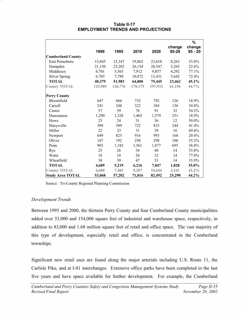
Cumberland and Perry Counties Safety and Congestion Management Systems Study Page II-55
Revised Final Report November 20, 2002
Table II-17 EMPLOYMENT TRENDS AND PROJECTIONS
Source: Tri-County Regional Planning Commission
Development Trends
Between 1995 and 2000, the thirteen Perry County and four Cumberland County municipalities
added over 53,000 and 154,000 square feet of industrial and warehouse space, respectively, in
addition to 83,000 and 1.68 million square feet of retail and office space. The vast majority of
this type of development, especially retail and office, is concentrated in the Cumberland
townships.
Significant new retail uses are found along the major arterials including U.S. Route 11, the
Carlisle Pike, and at I-81 interchanges. Extensive office parks have been completed in the last
five years and have space available for further development. For example, the Cumberland
1990 1995 2010 2020 change 95-20
% change 95 - 20
Cumberland County
East Pennsboro 13,845 15,347 19,862 23,610 8,263 53.8%
Hampden 21,130 23,282 26,154 28,547 5,265 22.6%
Middlesex 6,701 5,565 7,912 9,857 4,292 77.1%
Silver Spring 6,703 7,789 10,872 13,431 5,642 72.4%
TOTAL 48,379 51,983 64,800 75,445 23,462 45.1%
County TOTAL 125,985 136,776 170,175 197,932 61,156 44.7%
Perry County
Bloomfield 647 666 735 792 126 18.9%
Carroll 241 248 322 384 136 54.8%
Centre 57 59 76 91 32 54.2%
Duncannon 1,290 1,328 1,465 1,579 251 18.9%
Howe 23 24 31 36 12 50.0%
Marysville 589 589 722 833 244 41.4%
Miller 22 23 31 39 16 69.6%
Newport 649 825 916 993 168 20.4%
Oliver 187 192 250 298 106 55.2%
Penn 903 1,182 1,561 1,877 695 58.8%
Rye 25 26 34 40 14 53.8%
Watts 18 18 26 32 14 77.8%
Wheatfield 38 39 47 53 14 35.9%
TOTAL 4,689 5,219 6,216 7,047 1,828 35.0%
County TOTAL 6,600 7,483 9,207 10,644 3,161 42.2%
Study Area TOTAL 53,068 57,202 71,016 82,492 25,290 44.2%
Cumberland and Perry Counties Safety and Congestion Management Systems Study Page II-56
Revised Final Report November 20, 2002
Technology Park in Hampden Township is comprised of 218 acres. The Patriot News printing
and distribution facility and Pinnacle Health Outpatient Clinic, totaling over 275,000 square feet,
have already been constructed. Over 100 acres of the park remain to be developed.
Recent residential, commercial, and industrial development has contributed significantly to the
population and employment increases described above. The sewered and developed areas map,
which is located in the Technical Appendix, shows the locations of this development, as well as
sewer service areas, which have a significant effect on the location and density development in
the study area. Most development is found in the Cumberland County townships. In Perry
County, Carroll Township has experienced the most new development, especially new
residential subdivisions. Commercial and industrial development in Perry is found along U.S.
11/15 and near Shermans Dale on PA Route 34 in Carroll Township.
Land Use Planning Activities
Land use controls such as zoning ordinances and comprehensive plans guide the location and
extent of future development. All of the municipalities have a Subdivision and Land
Development Ordinance (SALDO) as required by Pennsylvania law. Most have a
Comprehensive Plan and 13 of the 17 municipalities have zoning regulations. Since preparation
of the Demographic Technical Memorandum in June of 2001, Watts Township has enacted
zoning. Recent Act 537 Plans, which details future plans for the construction of public sewer
facilities, have been prepared by seven communities. The four boroughs in the study area that
have public sewer systems likely prepared Act 537 plans in the past, even though those plans are
no longer available.
In Perry County, public sewer is currently available in and immediately adjacent to the four
boroughs, along US 11/15 in southeastern Penn Township, and in the village of Shermans Dale.
Future expansion of service is expected around Marysville, Duncannon, Perdix, and Newport,
and to a small area adjacent to Bloomfield. In Cumberland County public sewer is available in
much of East Pennsboro and Hampden Townships, along major arterials in Middlesex and Silver
Spring Townships, and near the Mechanicsburg border in Silver Spring. Public water is
available in Cumberland in generally the same areas as public sewer, although the sewered area

Cumberland and Perry Counties Safety and Congestion Management Systems Study Page II-57
Revised Final Report November 20, 2002
is slightly more extensive in Middlesex, Hampden, and East Pennsboro Townships. In Perry
County, public water is available in and near the four boroughs and along PA 850 in eastern Rye
Township.
Key policies for each municipality that affect future development are summarized in the
Appendix, including permitted densities for new development, provisions for cluster and planned
residential development, village zoning, and restrictions placed on development due to the
presence of various environmental resources. The zoning of key study area corridors is also
provided. This information and recommendations for future growth management strategies are
further addressed in Chapter VII.
Cumberland and Perry Counties Safety and Congestion Management Systems Study Page III-1
Revised Final Report November 20, 2002
CHAPTER III
ENVIRONMENTAL FEATURES SUMMARY
The project team has performed an inventory of the environmental features of the entire 17-
municipality Study area in Cumberland and Perry Counties. The existing environmental features
within the study area have been summarized in order to provide a preliminary assessment of the
potential environmental impacts of the proposed transportation improvement plans contained
within this study.
Data collection included secondary source GIS information provided by the Tri-County Regional
Planning Commission, GIS information provided from a variety of state and county sources,
secondary literature and internet searches, interviews with local officials, and limited field
reconnaissance/verification.
The locations of the following environmental features are shown on the seven foldout maps
attached to this document:
¶ Soils, Geology, Groundwater, Archeological, and Historical Features
¶ Agricultural Lands
¶ Surface Waters and Wetlands/Wildlife Habitat Areas
¶ Community Facilities
¶ Public Facilities
¶ Businesses and Employment Centers
¶ Section 4(f) and 2002 Resources
Detailed analyses and explanations of the Environmental Inventory are given in the
Environmental Features Inventory and Overview Report, dated August 2001.

Cumberland and Perry Counties Safety and Congestion Management Systems Study Page IV-1
Revised Final Report November 20, 2002
CHAPTER IV
YEAR 2020 NO-BUILD FUTURE VOLUMES AND TRANSPORTATION CONDITONS
The estimation of future traffic volumes for this study involved the use of a travel projection
model that utilizes existing trends and basic demographic inputs. These inputs are then
translated into traffic volumes that are distributed to the study area highway system.
The Tri-County Regional Planning Commission (TCRPC) has a functional travel demand model
that has been used to develop travel projections on other projects, such as Capital Area Transit’s
Corridor ONE Study. The TCRPC travel demand model was used to prepare a set of traffic
projections for the year 2020 for this study.
The traffic counts that were conducted in April 2001 were used in conjunction with the TCRPC
traffic model to develop a calibration set of existing traffic volumes for the entire study area. A
comparison between the model outputs for the year 1995 calibration data set and the traffic
counts conducted for this project allowed for the development of a series of comparative growth
factors for the model data.
The population, housing, and employment projections and the projected development areas
summarized in Chapter II were used to refine the traffic analysis zone data in the traffic model.
The demographic projections were then used along with the calibrated model to execute the
model for the year 2020 travel projections. The travel projections will be used to determine the
future traffic conditions on the study area roadways and the need for improvements on these
roadways.
The year 2020 no-build scenario assumes that planned future development identified in the study
area would occur, but that no highway or roadway improvements would occur along study area
roadways.

Cumberland and Perry Counties Safety and Congestion Management Systems Study Page IV-2
Revised Final Report November 20, 2002
The information presented in this chapter contains a summary of the projected year 2020 no-build
scenario traffic volumes, conditions, and analyses for this study area. The demographic
(population and employment) projections are located at the end of Chapter II (page II-52). All
detailed technical information can be found in the Technical Appendix.
A. Year 2020 No-Build Scenario Future Traffic Volumes
The projected year 2020 no-build average daily traffic volumes are shown on Figure IV-1. The
existing average daily traffic volumes are compared to the projected year 2020 no-build traffic
volumes on Table IV-1.
The year 2020 average daily traffic volumes show that traffic volumes on the study area
roadways are generally 30 to 35 percent greater than the year 2001 existing traffic volumes. This
translates to 1.5 to 2 percent annual increase in traffic volume.
The highest average daily traffic volumes in Perry County are on projected to be on US Routes
22/322 (26,500 vehicles per day north of US Routes 11/15), US Routes 11/15 (29,500 vehicles
per day between the Cumberland County border and PA Route 850), and PA Route 34 (23,500
vehicles per day between the Cumberland County border and PA Route 850).

Cumberland and Perry Counties Safety and Congestion Management Systems Study Page IV-3
Revised Final Report November 20, 2002
Table IV-1
AVERAGE DAILY TRAFFIC (ADT) VOLUME COMPARISON
Location 2001 Existing ADT 2020 No Build ADT
PA 34 - N of US 22/322 2,100 2,800
PA 34 - Bet US 22/322 and PA 849 7,500 10,000
PA 34 - Bet PA 849 and PA 274 5,200 6,900
PA 34 - Bet PA 274 and PA 274 8,250 10,700
PA 34 - Bet PA 274 and PA 850 7,250 9,400
PA 34 - Bet PA 850 and PA 850 13,800 17,900
PA 34 - Bet PA 850 and Sunnyside Dr 17,550 23,500
PA 34 - Bet Sunnyside Dr and PA 944 4,300 9,400
PA 944 - W of PA 34 850 1,100
PA 944 - Bet PA 34 and Sunnyside Dr 1,950 6,700
PA 944 - Bet Sunnyside Dr and PA 114 13,600 21,900
PA 944 - Bet PA 114 and I-81 6,100 11,800
PA 944 - Bet I-81 and US 11/15 11,800 15,700
US 11/15 - N of US 22/322 16,000 21,200
US 11/15 - Bet US 22/322 and PA 274 13,600 18,000
US 11/15 - Bet PA 274 and PA 850 16,350 22,300
US 11/15 - Bet PA 850 and I-81 22,000 29,500
US 11/15 - Bet I-81 and PA 944 21,750 29,500
US 11/15 - S of PA 944 21,750 37,000
PA 274 - W of PA 34 5,450 7,200
PA 274 - E of PA 34 3,500 4,700
PA 274 - W of US 11/15 9,350 13,000
PA 850 - W of PA 34 5,850 7,800
PA 850 - E of PA 34 3,050 4,200
PA 850 - W of US 11/15 5,400 7,400
PA 849 - W of PA 34 850 1,100
PA 849 - E of PA 34 1,200 1,600
PA 849 - W of US 22/322 4,850 8,000
I-81 - Bet PA 114 and PA 944 49,000 65,000
I-81 - Bet PA 944 and US 11/15 53,000 70,300
I-81 - Bet US 11/15 and Front Street 59,000 78,300
I-81 - Bet Front Street and US 22/322 66,000 87,600
US 22/322 - W of PA 34 20,300 26,900
US 22/322 - Bet PA 34 and US 11/15 20,000 26,500
US 22/322 - Bet US 11/15 and PA 849 35,600 38,100
US 22/322 - Bet PA 849 and PA 147 40,000 44,300
Sunnyside Dr (SR 1007) 11,000 14,200
Carlisle Cutoff 850 1,100
Lambs Gap Road 750 1,000

No
Bu
ild
20
20
Av
era
ge
Da
ily T
raff
ic V
olu
me
s
Sa
fety
an
d C
on
ge
sti
on
Ma
na
ge
men
t S
ys
tem
Stu
dy
CU
MB
ER
LA
ND
AN
DP
ER
RY
CO
UN
TIE
S,P
EN
NS
YLV
AN
IA
2,8
00
6,7
00
1,1
00
9,4
00
23
,50
0
17
,90
0
9,4
00
10
,70
0
6,9
00
10
,00
0
4,7
00
7,2
00
29
,50
0
29
,50
0
22
,30
0
18
,00
0
21
,20
0
15
,70
0
11
,80
02
1,9
00
37
,00
0
65
,00
0
8,0
00
1,6
00
7,4
00
4,2
00
7,8
00
13
,00
0
1,1
00
70
,30
0
38
,10
0
26
,50
0
26
,90
0
87
,60
0
78
,30
0
44
,30
0
14
,20
0
1,1
00
1,0
00
Leg
end
: 3
,050
= T
wo-w
a y A
ver
age
Dai
ly T
raff
ic V
olu
me
Fig
ure
IV
-1

Cumberland and Perry Counties Safety and Congestion Management Systems Study Page IV-5
Revised Final Report November 20, 2002
B. Year 2020 No-Build Scenario Future Levels of Service
A summary of the year 2020 no-build overall intersection levels of service are shown in Table
IV-2. For the sake of comparison, the existing levels of service are also shown in the table. The
undesirable levels of service are shown in boldface and the failing levels of service are shaded in
gray. The levels of service shown represent the intersection levels of service with no
improvements to the existing roadway system.
Most of the intersections are shown as having currently undesirable levels of service and many
intersections exhibit failing levels of service during the existing and no-build peak periods. At
the unsignalized intersections, motorists traveling unimpeded on the main street through the
intersections generally will not experience delay; as is the case today, motorists on the side
streets will experience the undesirable and failing levels of service as they wait at the stop-
controlled intersections for gaps in the mainstream traffic. Due to the projected increase in
traffic volumes, the totals at the bottom of the table show that more intersections will experience
unacceptable levels of service in year 2020 than in year 2001. The intersections at the northern
end of the study area are still projected to experience acceptable levels of service.
The projected year 2020 mid-block levels of service for two of the most heavily traveled two-
lane roadways in the study area are compared to the existing mid-block level of service in Table
IV-3. An undesirable level of service is common in the two-lane level of service analysis
because the parameter used for the classification of level of service is the proportion of time
spent following other vehicles within a platoon. That being said, the roadway is not over
capacity until a mid-block Level of Service ‘F’ is achieved. New alignments that bypass existing
roadways are not usually needed until the existing roadway is over capacity.
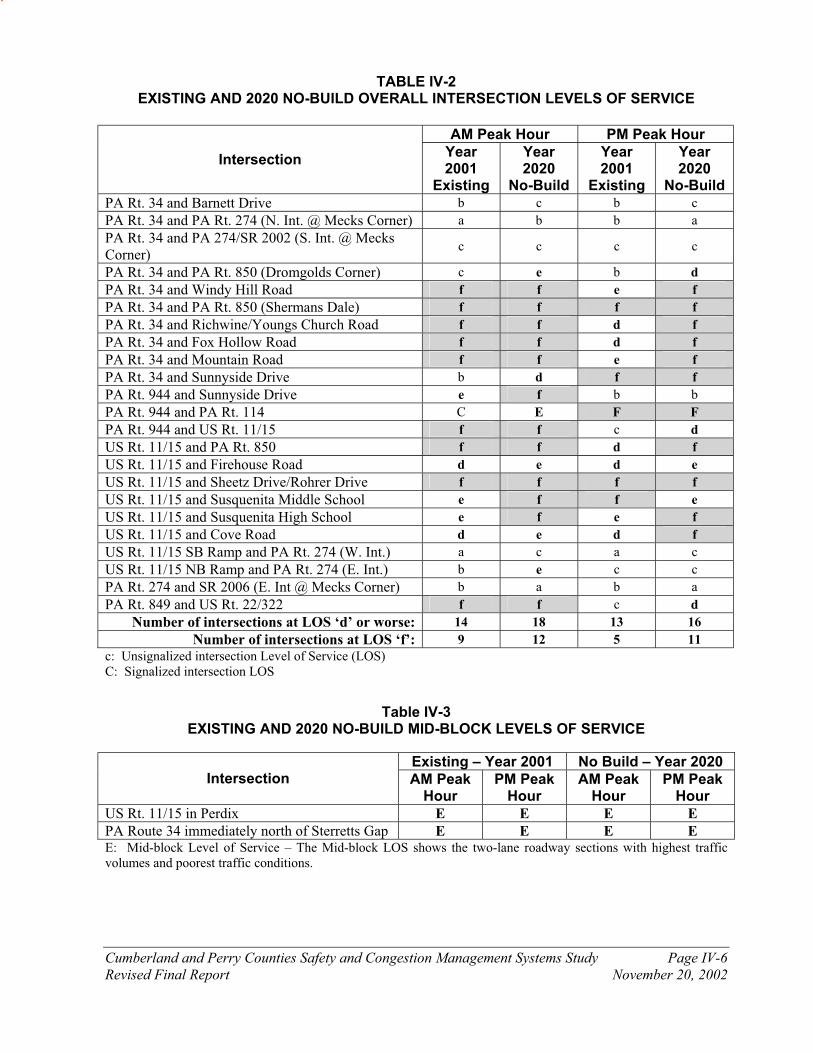
Cumberland and Perry Counties Safety and Congestion Management Systems Study Page IV-6
Revised Final Report November 20, 2002
TABLE IV-2 EXISTING AND 2020 NO-BUILD OVERALL INTERSECTION LEVELS OF SERVICE
AM Peak Hour PM Peak Hour
Intersection Year 2001
Existing
Year 2020
No-Build
Year 2001
Existing
Year 2020
No-Build
PA Rt. 34 and Barnett Drive b c b c
PA Rt. 34 and PA Rt. 274 (N. Int. @ Mecks Corner) a b b a
PA Rt. 34 and PA 274/SR 2002 (S. Int. @ Mecks Corner)
c c c c
PA Rt. 34 and PA Rt. 850 (Dromgolds Corner) c e b d
PA Rt. 34 and Windy Hill Road f f e f
PA Rt. 34 and PA Rt. 850 (Shermans Dale) f f f f
PA Rt. 34 and Richwine/Youngs Church Road f f d f
PA Rt. 34 and Fox Hollow Road f f d f
PA Rt. 34 and Mountain Road f f e f
PA Rt. 34 and Sunnyside Drive b d f f
PA Rt. 944 and Sunnyside Drive e f b b
PA Rt. 944 and PA Rt. 114 C E F F
PA Rt. 944 and US Rt. 11/15 f f c d
US Rt. 11/15 and PA Rt. 850 f f d f
US Rt. 11/15 and Firehouse Road d e d e
US Rt. 11/15 and Sheetz Drive/Rohrer Drive f f f f
US Rt. 11/15 and Susquenita Middle School e f f e
US Rt. 11/15 and Susquenita High School e f e f
US Rt. 11/15 and Cove Road d e d f
US Rt. 11/15 SB Ramp and PA Rt. 274 (W. Int.) a c a c
US Rt. 11/15 NB Ramp and PA Rt. 274 (E. Int.) b e c c
PA Rt. 274 and SR 2006 (E. Int @ Mecks Corner) b a b a
PA Rt. 849 and US Rt. 22/322 f f c d
Number of intersections at LOS ‘d’ or worse: 14 18 13 16
Number of intersections at LOS ‘f’: 9 12 5 11
c: Unsignalized intersection Level of Service (LOS) C: Signalized intersection LOS
Table IV-3
EXISTING AND 2020 NO-BUILD MID-BLOCK LEVELS OF SERVICE
Existing – Year 2001 No Build – Year 2020 Intersection AM Peak
Hour PM Peak
Hour AM Peak
Hour PM Peak
Hour
US Rt. 11/15 in Perdix E E E E
PA Route 34 immediately north of Sterretts Gap E E E E E: Mid-block Level of Service – The Mid-block LOS shows the two-lane roadway sections with highest traffic volumes and poorest traffic conditions.

Cumberland and Perry Counties Safety and Congestion Management Systems Study Page V-1
Revised Final Report November 20, 2002
CHAPTER V
NEW ROADWAY ALTERNATIVES YEAR 2020 BUILD SCENARIO FUTURE VOLUMES
AND TRANSPORTATION CONDITONS
A number of new roadway alternatives were examined as part of this study as possible
improvements to the existing transportation system. The presence of the new alternatives will
affect the traffic volumes and the traffic patterns on the existing roadway system. This chapter
summarizes the new roadway alternatives and their effect on the study area transportation
system. The detailed technical information can be found in the Technical Appendix.
A. New Roadway Alternatives
The US Routes 11/15 corridor and the PA Route 34 corridor are the two major north-south routes
between Cumberland and Perry Counties. Because these roadways are expected to handle
significant increases in traffic volume over the next twenty years, the existing traffic congestion
along PA Route 34, Sunnyside Drive, and US Routes 11/15 will likely worsen.
It was determined that logical locations for the new roadway alternatives would be bypasses
parallel to PA Route 34 / Sunnyside Drive and US Routes 11/15. The three alternative bypasses
that were studied are shown on Figure V-1.
The southern terminus of Alternative A connects to the intersection of PA Route 944 and PA
Route 114 in Cumberland County. The new roadway then travels over the mountain and into
Perry County. Alternative A travels northward through Perry County on the east side of PA
Route 34 before terminating at PA Route 34 just north of Mecks Corner.
The southern terminus of Alternative B connects to US Routes 11/15 south of Marysville. The
roadway travels parallel to US Routes 11/15 bypassing the built-up areas of Marysville and
Perdix before connecting to the four-lane section of US Routes 11/15 near Duncannon.

Pro
po
se
d N
ew
Ro
ad
wa
y A
lte
rna
tiv
es
S
afe
ty a
nd
Co
ng
esti
on
Ma
na
ge
men
t S
ys
tem
Stu
dy
CU
MB
ER
LA
ND
AN
DP
ER
RY
CO
UN
TIE
S,P
EN
NS
YLV
AN
IA
Fig
ure
V-1

Cumberland and Perry Counties Safety and Congestion Management Systems Study Page V-3
Revised Final Report November 20, 2002
Alternative C is similar to Alternative B such that it acts as a bypass to US Routes 11/15.
Alternative C is a less expensive version of Alternative B; Alternative B has three to five
mountain ridges in its path, while Alternative C does not have any major ridge crossings.
Alternative C travels parallel to US Routes 11/15 bypassing the Perdix area. Its northern
terminus is south of Cove Road, and its southern terminus is south of Perdix but north of
Marysville.
B. Year 2020 Build Scenario Future Traffic Volumes
Each of the three roadway alternatives were coded separately into the traffic model to obtain the
year 2020 build scenario future traffic volumes.
The projected year 2020 build scenarios average daily traffic volumes for Alternatives A, B, and
C are shown on Figures V-2, V-3, and V-4, respectively. The existing and no-build scenario
average daily traffic volumes are compared to the projected year 2020 traffic volumes for the
build scenarios on the existing roadways in Table V-1.
A comparison of the average daily traffic volumes shows that the new roadway alternatives draw
traffic off of their companion parallel roadways. The new roadway alternatives solve the local
traffic problems; they do not solve the safety and traffic congestion problems of the entire study
area. Compared to the no-build traffic volumes, the Alternative A scenario traffic volumes
exhibit a decrease on PA Route 34, the Alternative B and C scenario traffic volumes display a
decrease on US Routes 11/15. The traffic volumes on PA Route 34 are negligibly affected by
the existence of Alternatives B and C, and the traffic volumes on US Routes 11/15 are negligibly
affected by the existence of Alternative A. The build scenario traffic volume information
demonstrates that the new roadway alternatives do not solve the traffic congestion problems of
the entire study area, and even with the new roadways, the many of the safety problems will still
exist.
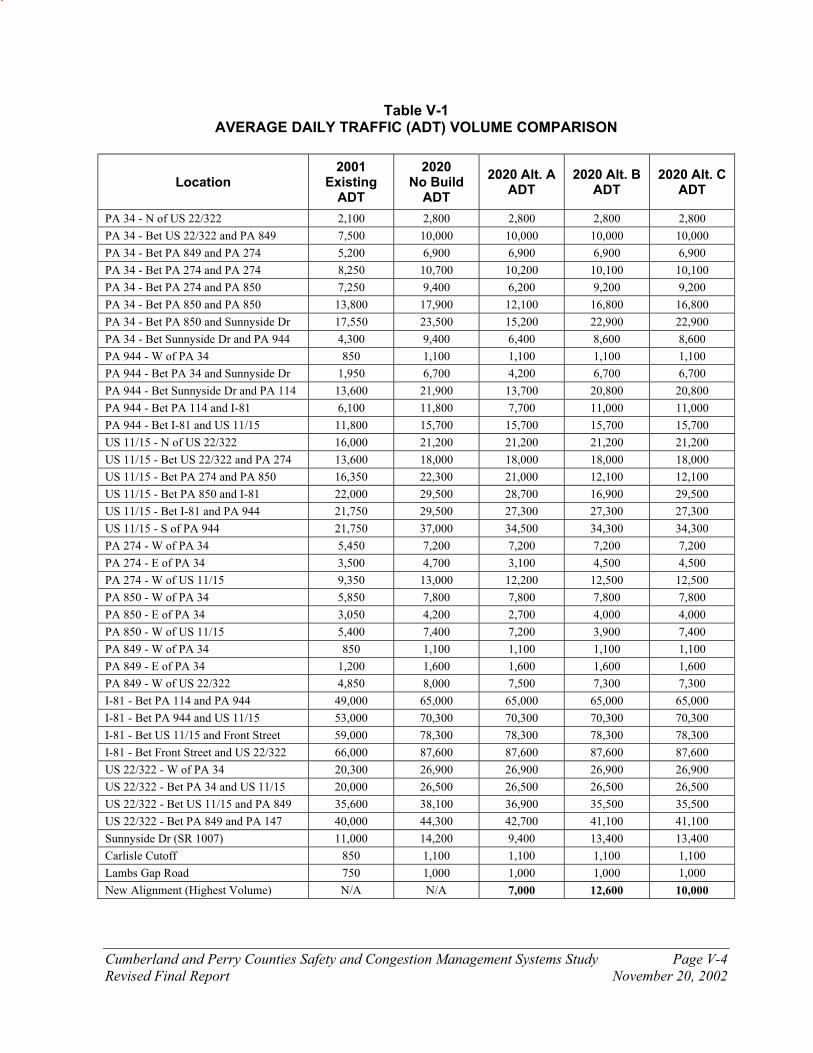
Cumberland and Perry Counties Safety and Congestion Management Systems Study Page V-4
Revised Final Report November 20, 2002
Table V-1 AVERAGE DAILY TRAFFIC (ADT) VOLUME COMPARISON
Location 2001
Existing ADT
2020 No Build
ADT
2020 Alt. A ADT
2020 Alt. B ADT
2020 Alt. C ADT
PA 34 - N of US 22/322 2,100 2,800 2,800 2,800 2,800
PA 34 - Bet US 22/322 and PA 849 7,500 10,000 10,000 10,000 10,000
PA 34 - Bet PA 849 and PA 274 5,200 6,900 6,900 6,900 6,900
PA 34 - Bet PA 274 and PA 274 8,250 10,700 10,200 10,100 10,100
PA 34 - Bet PA 274 and PA 850 7,250 9,400 6,200 9,200 9,200
PA 34 - Bet PA 850 and PA 850 13,800 17,900 12,100 16,800 16,800
PA 34 - Bet PA 850 and Sunnyside Dr 17,550 23,500 15,200 22,900 22,900
PA 34 - Bet Sunnyside Dr and PA 944 4,300 9,400 6,400 8,600 8,600
PA 944 - W of PA 34 850 1,100 1,100 1,100 1,100
PA 944 - Bet PA 34 and Sunnyside Dr 1,950 6,700 4,200 6,700 6,700
PA 944 - Bet Sunnyside Dr and PA 114 13,600 21,900 13,700 20,800 20,800
PA 944 - Bet PA 114 and I-81 6,100 11,800 7,700 11,000 11,000
PA 944 - Bet I-81 and US 11/15 11,800 15,700 15,700 15,700 15,700
US 11/15 - N of US 22/322 16,000 21,200 21,200 21,200 21,200
US 11/15 - Bet US 22/322 and PA 274 13,600 18,000 18,000 18,000 18,000
US 11/15 - Bet PA 274 and PA 850 16,350 22,300 21,000 12,100 12,100
US 11/15 - Bet PA 850 and I-81 22,000 29,500 28,700 16,900 29,500
US 11/15 - Bet I-81 and PA 944 21,750 29,500 27,300 27,300 27,300
US 11/15 - S of PA 944 21,750 37,000 34,500 34,300 34,300
PA 274 - W of PA 34 5,450 7,200 7,200 7,200 7,200
PA 274 - E of PA 34 3,500 4,700 3,100 4,500 4,500
PA 274 - W of US 11/15 9,350 13,000 12,200 12,500 12,500
PA 850 - W of PA 34 5,850 7,800 7,800 7,800 7,800
PA 850 - E of PA 34 3,050 4,200 2,700 4,000 4,000
PA 850 - W of US 11/15 5,400 7,400 7,200 3,900 7,400
PA 849 - W of PA 34 850 1,100 1,100 1,100 1,100
PA 849 - E of PA 34 1,200 1,600 1,600 1,600 1,600
PA 849 - W of US 22/322 4,850 8,000 7,500 7,300 7,300
I-81 - Bet PA 114 and PA 944 49,000 65,000 65,000 65,000 65,000
I-81 - Bet PA 944 and US 11/15 53,000 70,300 70,300 70,300 70,300
I-81 - Bet US 11/15 and Front Street 59,000 78,300 78,300 78,300 78,300
I-81 - Bet Front Street and US 22/322 66,000 87,600 87,600 87,600 87,600
US 22/322 - W of PA 34 20,300 26,900 26,900 26,900 26,900
US 22/322 - Bet PA 34 and US 11/15 20,000 26,500 26,500 26,500 26,500
US 22/322 - Bet US 11/15 and PA 849 35,600 38,100 36,900 35,500 35,500
US 22/322 - Bet PA 849 and PA 147 40,000 44,300 42,700 41,100 41,100
Sunnyside Dr (SR 1007) 11,000 14,200 9,400 13,400 13,400
Carlisle Cutoff 850 1,100 1,100 1,100 1,100
Lambs Gap Road 750 1,000 1,000 1,000 1,000
New Alignment (Highest Volume) N/A N/A 7,000 12,600 10,000

Alt
ern
ati
ve
A 2
02
0 A
ve
rag
e D
ail
y T
raff
ic V
olu
me
s
Sa
fety
an
d C
on
ge
sti
on
Ma
na
ge
men
t S
ys
tem
Stu
dy
CU
MB
ER
LA
ND
AN
DP
ER
RY
CO
UN
TIE
S,P
EN
NS
YLV
AN
IA
Leg
end
: 3
,050
= T
wo-w
a y A
ver
age
Dai
ly T
raff
ic V
olu
me
2,8
00
4,2
00
1,1
00
6,4
00
15
,20
0
12
,10
0
6,2
00
10
,20
0
6,9
00
10
,00
0
3,1
00
7,2
00
27
,30
0
28
,70
0
21
,00
0
18
,00
0
21
,20
0
15
,70
0
7,7
00
1
3,7
00
34
,50
0
65
,00
0
7,5
00
1,6
00
7,2
00
2,7
00
7,8
00
12
,20
0
1,1
00
70
,30
0
36
,90
0
26
,50
0
26
,90
0
87
,60
0
78
,30
0
42
,70
0
9,4
00
1,1
00
1,0
00
5,5
00
7,4
00
Fig
ure
V-2

Alt
ern
ati
ve
B 2
02
0 A
ve
rag
e D
ail
y T
raff
ic V
olu
me
s
Sa
fety
an
d C
on
ge
sti
on
Ma
na
ge
men
t S
ys
tem
Stu
dy
CU
MB
ER
LA
ND
AN
DP
ER
RY
CO
UN
TIE
S,P
EN
NS
YLV
AN
IA
2,8
00
6,7
00
1,1
00
8,6
00
22
,90
0
16
,80
0
9,2
00
10
,10
0
6,9
00
10
,00
0
4,5
00
7,2
00
27
,30
0
16
,90
0
12
,10
0
18
,00
0
21
,20
0
15
,70
0
11
,00
02
0,8
00
34
,30
0
65
,00
0
7,3
00
1,6
00
3,9
00
4,0
00
7,8
00
12
,50
0
1,1
00
70
,30
0
35
,50
0
26
,50
0
26
,90
0
87
,60
0
78
,30
0
41
,10
0
13
,40
0
1,1
00
1,0
00
12
,60
0
9,9
00
Leg
end
: 3
,050
= T
wo-w
a y A
ver
age
Dai
ly T
raff
ic V
olu
me Fig
ure
V-3

Alt
ern
ati
ve
C 2
02
0 A
ve
rag
e D
ail
y T
raff
ic V
olu
me
s
Sa
fety
an
d C
on
ge
sti
on
Ma
na
ge
men
t S
ys
tem
Stu
dy
CU
MB
ER
LA
ND
AN
DP
ER
RY
CO
UN
TIE
S,P
EN
NS
YLV
AN
IA
2,8
00
6,7
00
1,1
00
8,6
00
22
,90
0
16
,80
0
9,2
00
10
,10
0
6,9
00
10
,00
0
4,5
00
7,2
00
27
,30
0
29
,50
0
12
,10
0
18
,00
0
21
,20
0
15
,70
0
11
,00
02
0,8
00
34
,30
0
65
,00
0
7,3
00
1,6
00
7,4
00
4
,00
0
7,8
00
12
,50
0
1,1
00
70
,30
0
35
,50
0
26
,50
0
26
,90
0
87
,60
0
78
,30
0
41
,10
0
13
,40
0
1,1
00
1,0
00
9,9
00
Leg
end
: 3
,050
= T
wo-w
a y A
ver
age
Dai
ly T
raff
ic V
olu
me
Fig
ure
V-4
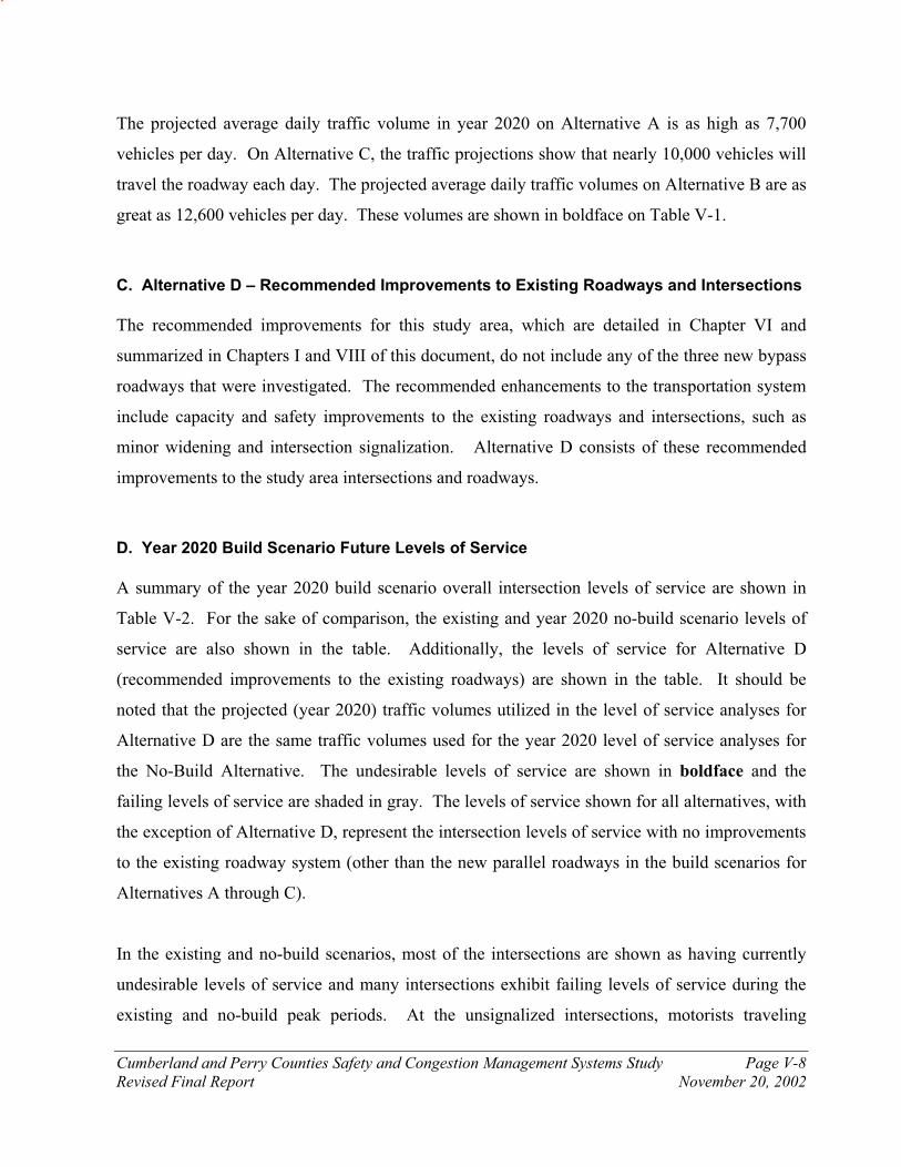
Cumberland and Perry Counties Safety and Congestion Management Systems Study Page V-8
Revised Final Report November 20, 2002
The projected average daily traffic volume in year 2020 on Alternative A is as high as 7,700
vehicles per day. On Alternative C, the traffic projections show that nearly 10,000 vehicles will
travel the roadway each day. The projected average daily traffic volumes on Alternative B are as
great as 12,600 vehicles per day. These volumes are shown in boldface on Table V-1.
C. Alternative D – Recommended Improvements to Existing Roadways and Intersections
The recommended improvements for this study area, which are detailed in Chapter VI and
summarized in Chapters I and VIII of this document, do not include any of the three new bypass
roadways that were investigated. The recommended enhancements to the transportation system
include capacity and safety improvements to the existing roadways and intersections, such as
minor widening and intersection signalization. Alternative D consists of these recommended
improvements to the study area intersections and roadways.
D. Year 2020 Build Scenario Future Levels of Service
A summary of the year 2020 build scenario overall intersection levels of service are shown in
Table V-2. For the sake of comparison, the existing and year 2020 no-build scenario levels of
service are also shown in the table. Additionally, the levels of service for Alternative D
(recommended improvements to the existing roadways) are shown in the table. It should be
noted that the projected (year 2020) traffic volumes utilized in the level of service analyses for
Alternative D are the same traffic volumes used for the year 2020 level of service analyses for
the No-Build Alternative. The undesirable levels of service are shown in boldface and the
failing levels of service are shaded in gray. The levels of service shown for all alternatives, with
the exception of Alternative D, represent the intersection levels of service with no improvements
to the existing roadway system (other than the new parallel roadways in the build scenarios for
Alternatives A through C).
In the existing and no-build scenarios, most of the intersections are shown as having currently
undesirable levels of service and many intersections exhibit failing levels of service during the
existing and no-build peak periods. At the unsignalized intersections, motorists traveling

Cumberland and Perry Counties Safety and Congestion Management Systems Study Page V-9
Revised Final Report November 20, 2002
unimpeded on the main street through the intersections generally will not experience delay;
motorists on the side streets will experience the undesirable and failing levels of service as they
wait at the stop-controlled intersections for gaps in the mainstream traffic, which is the case
today.
With the new roadways constructed under the build scenario, the levels of service show
improvement on the intersections parallel to their associated bypasses (Alternatives A through
C). However, the intersections on roadways that are not located near the bypasses still exhibit
poor levels of service. For example, PA Route 34 shows improved levels of service under
Alternative A, which lies closely parallel to the existing PA Route 34. The improvements
become apparent by comparing the LOS F on the PA Route 34 intersections under the other
alternatives to LOS D under Alternative A. The locations of the boldface text / gray shaded
areas and the numbers at the bottom of Table V-2 demonstrate this phenomenon. The
intersections at the northern end of the study area are projected to experience acceptable levels of
service under all scenarios and peak hours. The level of service analyses for Alternative D,
which includes all of the recommended improvements to the existing roadways (with no bypass
roadways), shows a dramatic improvement for most of the study area intersections when
compared to the No-Build and Build Alternatives (A through C) levels of service. In addition,
the recommended improvements under Alternative D will mitigate many of the current safety
problems in addition to the projected congestion problems that are expected to be experienced on
the study area roadways.
The projected year 2020 build scenario mid-block levels of service for two of the most heavily
traveled two-lane roadways in the study area are compared to the existing and no-build mid-
block level of service in Table V-3. An undesirable level of service is common in the two-lane
level of service analysis because the parameter used for the classification of level of service is
the proportion of time spent following other vehicles within a platoon.
The mid-block level of service comparison table demonstrates that the presence of the new
alignments have no effect on the resulting mid-block levels of service. The most heavily
traveled roadways exhibit a Level of Service ‘E’ regardless of the alternative in year 2020.
Cumberland and Perry Counties Safety and Congestion Management Systems Study Page V-10
Revised Final Report November 20, 2002
While a Level of Service ‘E’ is undesirable, the roadway is not over capacity until a mid-block
Level of Service ‘F’ is achieved. New alignments that bypass existing roadways are not usually
needed until the existing roadway is over capacity.
The projected traffic volumes and the results of the level of service analyses demonstrate that the
presence of the new roadway alternatives do not have a significant effect on the traffic volumes
and traffic conditions of the regional roadways, but the new alternatives do affect the traffic
volumes and the capacity of the intersections on the roadways to which they are parallel. The
new roadway alternatives may solve some of the capacity problems of the intersections on the
roadways to which they are parallel, but they do not solve the safety problems of their existing
parallel roadways, and they do not solve the regional traffic congestion and safety problems of
the study area. For the projected cost of a new roadway over the mountainous terrain, the new
bypass should be an effective solution. The new bypasses are not an effective solution because
the projected 20-year traffic volumes do not put the most heavily traveled existing roadways over
capacity. It is a fact that there are limited financial resources; a different strategy in investment
will make better use of the available funds in order to solve the safety and congestion problems
that exist and are projected to occur in the study area. The new roadway alternatives
(Alternatives A, B, and C) would not solve many of the sight distance related safety problems
that currently exist on the study area roadway corridors. The recommended improvements
(Alternative D) will improve the level of service of the transportation system and will alleviate
many of the safety problems exhibited on the study area roadways in a more fiscally efficient and
environmentally friendly manner than would a new bypass roadway.
The recommended improvements (Alternative D) are detailed in Chapter VI and are summarized
in Chapters I and VIII of this document.

Cu
mb
erla
nd
an
d P
erry
Co
un
ties
Sa
fety
an
d C
on
ges
tio
n M
an
ag
emen
t S
yste
ms
Stu
dy
Pa
ge
V-1
1
Rev
ised
Fin
al
Rep
ort
N
ove
mb
er 2
0,
20
02
TA
BL
E V
-2
EX
IST
ING
AN
D F
UT
UR
E O
VE
RA
LL
IN
TE
RS
EC
TIO
N L
EV
EL
S O
F S
ER
VIC
E
A
M P
eak H
ou
r P
M P
eak H
ou
r
Inte
rse
cti
on
Y
ear
200
1
Ex
isti
ng
Year
202
0
No
-B
uil
d
Year
202
0
Alt
. A
Year
202
0
Alt
. B
Year
202
0
Alt
. C
Year
202
0
Alt
. D
Year
200
1
Ex
isti
ng
Year
202
0
No
-B
uil
d
Year
202
0
Alt
. A
Year
202
0
Alt
. B
Year
202
0
Alt
. C
Year
202
0
Alt
. D
PA
Rt.
34 a
nd
Bar
net
t D
rive
b
c b
b
b
c
b
c c
c c
c
PA
Rt.
34 a
nd
PA
Rt.
27
4 (
N.
Int.
@ M
eck
s C
orn
er)
a b
a
a a
b
b
a b
b
b
a
PA
Rt.
34 a
nd
PA
27
4/S
R 2
00
2 (
S.
Int.
@ M
eck
s C
orn
er)
c c
b
c c
c c
c b
c
c c
PA
Rt.
34 a
nd
PA
Rt.
85
0 (
Dro
mg
old
s C
orn
er)
c e
b
d
d
e b
d
b
c
c d
PA
Rt.
34 a
nd
Win
dy
Hil
l R
oad
f
f d
f
f B
e
f d
f
f B
PA
Rt.
34 a
nd
PA
Rt.
85
0 (
Sh
erm
ans
Dal
e)
f f
c f
f B
f
f d
f
f B
PA
Rt.
34 a
nd
Ric
hw
ine/
Yo
un
gs
Ch
urc
h R
oad
f
f d
f
f b
d
f
d
f f
a
PA
Rt.
34 a
nd
Fo
x H
oll
ow
Ro
ad
f f
d
f f
d
d
f c
f f
a
PA
Rt.
34 a
nd
Mo
un
tain
Ro
ad
f f
d
f f
D
e f
d
f f
B
PA
Rt.
34 a
nd
Su
nny
sid
e D
riv
e b
d
b
c
c D
f
f f
f f
C
PA
Rt.
94
4 a
nd
Su
nny
sid
e D
riv
e e
f c
f f
C
b
b
b
b
b
B
PA
Rt.
94
4 a
nd
PA
Rt.
11
4
C
E
B
B
B
B
F
F
B
E
E
B
PA
Rt.
94
4 a
nd
US
Rt.
11
/15
f
f f
f f
a c
d
c c
c a
US
Rt.
11
/15 a
nd
PA
Rt.
85
0
f f
f c
f C
d
f
f b
f
B
US
Rt.
11
/15 a
nd
Fir
eho
use
Road
d
e
d
b
b
c d
e
e c
c c
US
Rt.
11
/15 a
nd
Sh
eetz
Dri
ve/
Ro
hre
r D
riv
e f
f f
c c
d
f f
f d
d
d
US
Rt.
11
/15 a
nd
Su
squ
enit
a M
idd
le S
cho
ol
e
f e
c c
c f
e f
c c
c
US
Rt.
11
/15 a
nd
Su
squ
enit
a H
igh
Sch
oo
l e
f f
c c
B
e f
f c
c B
US
Rt.
11
/15 a
nd
Co
ve
Road
d
e
e c
e e
d
f e
c f
f
US
Rt.
11
/15 S
B R
amp a
nd P
A R
t. 2
74 (
W.
Int.
) a
c b
b
b
c
a c
c c
c c
US
Rt.
11
/15 N
B R
amp
an
d P
A R
t. 2
74 (
E.
Int.
) b
e
c c
c e
c c
d
d
d
c
PA
Rt.
27
4 a
nd
SR
20
06
(E
. In
t @
Mec
ks
Co
rner
) b
a
a a
a a
b
a a
a a
a
PA
Rt.
84
9 a
nd
US
Rt.
22
/32
2
f f
f f
f f
c d
c
c c
d
Nu
mb
er o
f in
ters
ecti
on
s at
LO
S ‘
d’
or
wo
rse:
1
4
18
1
2
9
11
8
1
3
16
1
2
9
11
4
Nu
mb
er o
f in
ters
ecti
on
s a
t L
OS
‘f’
: 9
1
2
5
8
9
1
5
11
5
6
8
1
c:
Un
sig
nal
ized
in
ters
ecti
on L
evel
of
Ser
vic
e (L
OS
)
C:
Sig
nal
ized
inte
rsec
tio
n L
OS

Cu
mb
erla
nd
an
d P
erry
Co
un
ties
Sa
fety
an
d C
on
ges
tio
n M
an
ag
emen
t S
yste
ms
Stu
dy
Pa
ge
V-1
2
Rev
ised
Fin
al
Rep
ort
N
ove
mb
er 2
0,
20
02
T
ab
le V
-3
EX
IST
ING
AN
D F
UT
UR
E M
ID-B
LO
CK
LE
VE
LS
OF
SE
RV
ICE
A
M P
eak H
ou
r P
M P
eak H
ou
r
Inte
rse
cti
on
Y
ear
200
1
Ex
isti
ng
Year
202
0
No
-Bu
ild
Year
202
0
Alt
. A
Year
202
0
Alt
. B
Year
202
0
Alt
. C
Year
202
0
Alt
. D
Year
200
1
Ex
isti
ng
Year
202
0
No
-Bu
ild
Year
202
0
Alt
. A
Year
202
0
Alt
. B
Year
202
0
Alt
. C
Year
202
0
Alt
. D
US
Rt.
11
/15 i
n P
erd
ix
E
E
E
E
E
E
E
E
E
E
E
E
PA
Ro
ute
34
im
med
iate
ly n
ort
h o
f S
terr
etts
Gap
E
E
E
E
E
E
E
E
E
E
E
E
E:
Mid
-blo
ck L
evel
of
Ser
vic
e – T
he
Mid
blo
ck L
OS
sh
ow
s th
e tw
o-l
ane
road
way
sec
tio
ns
wit
h h
igh
est
traf
fic
vo
lum
es a
nd
po
ore
st t
raff
ic c
on
dit
ions.

Cumberland and Perry Counties Safety and Congestion Management Systems Study Page VI-1
Revised Final Report November 20, 2002
CHAPTER VI
SUMMARY OF PROPOSED IMPROVEMENTS TO EXISTING ROADWAYS AND INTERSECTIONS
Numerous safety and congestion problems currently exist on the study area roadway corridors.
By the year 2020, the increase in development and the resulting growth in traffic volume on the
more heavily traveled study area roadways (such as PA Route 34, US Routes 11/15, PA Route
944, and PA Route 274) will only worsen the existing problems, and will create a handful of new
safety and congestion issues. The new roadway alternatives described in Chapter V merely
mitigate the traffic congestion along roadways to which they are parallel. For the projected cost
of a new roadway over the mountainous terrain, the new bypass should be an effective solution.
The new bypasses are not an effective solution because the projected 20-year traffic volumes do
not put the most heavily traveled existing roadways over capacity. It is a fact that there are
limited financial resources; a different strategy in investment will make better use of the funds in
order to solve the safety and congestion problems that exist and are projected to occur in the
study area. The new roadway alternatives would not solve many of the sight distance related
safety problems that currently exist on the study area roadway corridors.
In order to solve the existing and projected safety and congestion problems within the study area,
capacity and safety improvements to the existing roadways and intersections must be
implemented. This chapter summarizes the proposed improvements to the existing study area
roadways.
A. Congestion Management System (CMS) Screening Process
Before the roadway improvements were formulated, the study area roadway corridors underwent
Congestion Management System (CMS) screening process. CMS screening is an integral part of
the National Environmental Policy Act (NEPA) process and meets the intent of the law by
providing the following:
¶ Systematic interdisciplinary approach to improvement alternative selection

Cumberland and Perry Counties Safety and Congestion Management Systems Study Page VI-2
Revised Final Report November 20, 2002
¶ Concentrates on issues pertaining to mobility and congestion
¶ Provides a broad range of alternatives for advancement into detailed study
Specific criteria were developed in order to provide a uniform and common performance basis
with which to evaluate the many ranges of traditional and non-traditional improvement options
along each roadway corridor. The CMS screening criteria are those which weed out clearly
ineligible or unfeasible projects.
The eight study area roadway corridors were subjected to the five CMS strategy groups listed
below, which are listed in order of highest priority to lowest priority. In other words, if a
roadway corridor meets the criteria for a strategy that is high on the list, that improvement option
should be examined before the strategies listed lower on the list are implemented (for example,
carpooling should be examined prior to adding lanes to the road if that particular corridor meets
the criteria for both strategies). The CMS five strategy groups and their associated subgroups
are:
¶ Eliminate person trips or vehicle miles traveled
o Growth management
o Congestion pricing
o Flex time
¶ Shift trips from the automobile to other modes of transportation (such as transit)
o Public transit capital improvements
o Public transit operational improvements
o Advanced public transportation systems
o Encourage use of non-traditional modes
¶ Shift trips from the automobile to High Occupancy Vehicle (HOV) (carpool / vanpool)
o Encourage HOV use
o Transportation demand management
¶ Improve highway operations
o Traffic operational improvements
o Highway operations and management
o Access management

Cumberland and Perry Counties Safety and Congestion Management Systems Study Page VI-3
Revised Final Report November 20, 2002
o Intelligent transportation systems
¶ Add general purpose capacity
o Addition of general purpose lanes
Within each of the strategy groups, there are two levels of screening: Level One screening and
Level Two Screening. The Level One screening consists of a general questions related to the
improvement option that is being tested for a particular roadway corridor. The Level Two
Screening asks more detailed questions pertaining to that improvement option for the roadway
corridor. If a particular improvement option passes the screening process for the Level One
criteria, then the more stringent Level Two screening process is applied. If that improvement
option passes the stricter standards of the Level Two screening process, then that improvement
alternative should be examined in further detail. The projects that do not pass the screening
criteria are usually not considered for further study.
An example of a Level One screening question for the implementation of commuter rail is: “Is
the corridor’s gross population density at least 2000 persons per square mile?” An example of a
Level Two screening question for commuter rail is: “Does the corridor’s major employment area
have an employment density of at least 15,000 people per square mile?” The specific criteria
used in the CMS screening process for each of the five strategy groups for each of the study area
roadway corridors are contained within the technical files for this project.
The bi-level CMS screening criteria were applied separately to each of the eight roadway
corridors in the study area. Generally, many of the transit related improvement options were
eliminated during this process because the population densities of the study area would not
support transit. The improvement strategies that were recommended from the CMS screening
process were used as a guide in the determination of the improvement concepts that are
summarized later in this chapter.
Table VI-1 summarizes the improvement strategies that were subjected to the CMS screening
process. The table also shows whether particular improvement strategies passed or failed the
Level One and Level Two screening process for each study area roadway corridor.

Pass
Fail
Gro
up
Su
bg
rou
pS
tra
teg
yL
ev
el
SR 34
SR 944
US 11/15
SR 850
SR 849
SR 274
I-81
US 22/322
Gro
wth
Managem
ent
Gro
wth
managem
ent
1 2
Pla
ce jobs a
nd h
ousin
g in p
roxim
ity to o
ne a
noth
er
1 2
Congestion p
ricin
gR
oad u
ser
fees
1 2
Park
ing fees
1 2
Tele
com
muting a
nd fle
xtim
eT
ele
com
muting
1 2
Fle
xtim
e1 2
Public
tra
nsit c
apital im
pro
vem
ents
Exclu
siv
e R
OW
: R
apid
rail
1 2
Exclu
siv
e R
OW
: C
om
mute
r ra
il1 2
Exclu
siv
e R
OW
: Lig
ht ra
il1 2
Exclu
siv
e R
OW
: B
usw
ays a
nd b
us b
ypass r
am
ps
1 2
Exclu
siv
e R
OW
: B
us lanes
1 2
Fle
et expansio
n1 2
Vehic
le r
epla
cem
ent/upgra
de
1 2
Impro
ved inte
rmodal connections
1 2
Tra
nsit p
ark
and r
ide facili
ties
1 2
Ta
ble
VI-
1
Cu
mb
erl
an
d a
nd
Pe
rry
Co
un
tie
s S
afe
ty a
nd
Co
ng
es
tio
n M
an
ag
em
en
t S
ys
tem
Stu
dy
Imp
rov
em
en
t C
on
ce
pt
Sc
ree
nin
g L
ev
el
1 a
nd
Le
ve
l 2
Su
mm
ary
Eliminate person trips or vehicle
miles traveledShift trips from automobile to other modes

Pass
Fail
Gro
up
Su
bg
rou
pS
tra
teg
yL
ev
el
SR 34
SR 944
US 11/15
SR 850
SR 849
SR 274
I-81
US 22/322
Ta
ble
VI-
1
Cu
mb
erl
an
d a
nd
Pe
rry
Co
un
tie
s S
afe
ty a
nd
Co
ng
es
tio
n M
an
ag
em
en
t S
ys
tem
Stu
dy
Imp
rov
em
en
t C
on
ce
pt
Sc
ree
nin
g L
ev
el
1 a
nd
Le
ve
l 2
Su
mm
ary
Public
tra
nsit o
pera
tional im
pro
vem
ents
Serv
ice p
rovis
ion/e
xpansio
n/e
nhancem
ent
1 2
Tra
ffic
sig
nal pre
-em
ption
1 2
Fare
reduction o
r re
duced r
ate
of fa
re incre
ases
1 2
Tra
nsit info
rmation s
yste
ms
1 2
Tra
nsit c
oord
ination
1 2
Incre
ased tra
nsit s
ecurity
1 2
Tra
nsit m
ark
eting
1 2
Advanced P
ublic
Tra
nsport
ation S
yste
ms
Inte
lligent bus s
tops
1 2
Advanced m
ode c
hoic
e s
yste
ms
1 2
Encoura
ge u
se o
f non-t
raditio
nal m
odes
Bic
ycle
facili
ties a
nd s
tora
ge s
yste
ms
1 2
Pedestr
ian facili
ties
1 2
Ferr
y s
erv
ice
1 2
Tra
ffic
calm
ing
1 2
Encoura
ge H
OV
use
HO
V lanes a
nd b
us b
ypass lanes
1 2
HO
V toll
savin
gs
1 2
HO
V a
nd c
arp
ool park
-n-r
ide lots
1 2
Guara
nte
ed r
ide h
om
e p
rogra
ms a
nd e
mplo
yer
trip
reduction p
rogra
ms
1 2
Tra
nsport
ation d
em
and m
anagem
ent
HO
V a
nd c
arp
ool park
ing m
anagem
ent
1 2
Rid
eshare
matc
hin
g s
erv
ices a
nd v
anpool pro
gra
ms
1 2
Shift trips from auto to HOV
auto/vanShift trips from automobile to other modes (continued from previous page)

Pass
Fail
Gro
up
Su
bg
rou
pS
tra
teg
yL
ev
el
SR 34
SR 944
US 11/15
SR 850
SR 849
SR 274
I-81
US 22/322
Ta
ble
VI-
1
Cu
mb
erl
an
d a
nd
Pe
rry
Co
un
tie
s S
afe
ty a
nd
Co
ng
es
tio
n M
an
ag
em
en
t S
ys
tem
Stu
dy
Imp
rov
em
en
t C
on
ce
pt
Sc
ree
nin
g L
ev
el
1 a
nd
Le
ve
l 2
Su
mm
ary
Tra
ffic
opera
tional im
pro
vem
ents
Inte
rsection g
eom
etr
ic im
pro
vem
ents
/channeliz
ation/turn
restr
ictions
1 2
Sig
naliz
ation im
pro
vem
ents
and c
om
pute
r sig
naliz
ed s
yste
ms
1 2
Roadw
ay w
idenin
g1 2
Tru
ck r
estr
ictions
1 2
Hig
hw
ay o
pera
tions a
nd m
anagem
ent
Elim
ination o
f bottle
necks
1 2
Com
merc
ial vehic
le lanes
1 2
Ram
p m
ete
ring
1 2
Dete
ction o
f in
cid
ents
, re
sponse, and c
leara
nce
1 2
Info
rmation d
istr
ibution a
nd a
ltern
ative r
ero
uting
1 2
Constr
uction m
anagem
ent
1 2
Access m
anagem
ent
Drivew
ay c
ontr
ol and fro
nta
ge r
oads
1 2
Media
n c
ontr
ol
1 2
Inte
lligent tr
ansport
ation s
yste
ms
Advanced tra
vele
r in
form
ation s
yste
m1 2
Com
merc
ial vehic
le o
pera
tions
1 2
Tra
ffic
surv
eill
ance a
nd c
ontr
ol syste
ms
1 2
Additio
n o
f genera
l purp
ose lanes
Fre
ew
ay lanes
1 2
Art
erial la
nes
1 2
Improve highway operations
Add
general
purpose
capacity

Cumberland and Perry Counties Safety and Congestion Management Systems Study Page VI-7
Revised Final Report November 20, 2002
B. Environmental Concerns
The environmental features of the study are a very important consideration when determining the
proposed improvements to the study area transportation system. The National Environmental
Policy (NEPA) Act of 1969 requires that all Federal agencies evaluate the environmental
consequences of any major action, including transportation projects. Since nearly all major
transportation projects utilize Federal funds, the NEPA laws are applicable, and environmental
consequences must be investigated.
The existing environmental features within this study area have been cataloged, and they have
been used in the formulation of the improvement concepts that are summarized later in this
chapter. The inventory of the existing environmental features has provided guidance for
avoidance by the proposed transportation improvement concepts that are situated near locations
of critical environmental features.
The environmental areas of concern are summarized in Table VI-2. The proposed improvement
areas are shown along with the identified environmental concerns. This table will provide
guidance in the future as some of the proposed improvement concepts reach the preliminary
design phase. The most serious environmental concerns will already have been documented, and
the preliminary designs of the improvements will be formulated with knowledge of the
environmental features in mind.
Pro
po
se
d I
mp
rov
em
en
t
Are
aW
etl
an
ds
His
tori
c R
es
ou
rce
sA
rch
eo
log
yS
ch
oo
lsC
em
ete
rie
sF
arm
lan
dN
atu
ral
Are
as
Tra
ils
an
d P
ark
sW
as
te S
ite
sF
loo
dp
lain
s/
Flo
od
wa
ys
Sc
en
ic R
ive
rsE
nv
iro
nm
en
tal
Ju
sti
ce
INT
ER
ST
AT
E 8
1X
XX
XX
X
I-8
1 f
rom
94
4 t
o 5
81
Tw
o h
isto
ric r
esourc
es a
dja
cent
to 8
1 s
outh
bound o
n r
am
p fro
m
944
PA
SS
site n
ear
944/8
1 inte
rchange,
are
as o
f hig
h p
rehis
toric p
ote
ntial near
str
eam
s
Shaull
Ele
menta
ry -
south
west of
944/8
1
inte
rchange
Mt Z
ion -
south
east
of 944/8
1
inte
rchange
Prim
e F
arm
land s
oils
and
active farm
land
thro
ughout
I-8
1 f
rom
58
1 t
o 2
2/3
22
-
inte
rch
an
ge
s
Tw
o h
isto
ric r
esourc
es a
dja
cent
to 8
1 s
outh
bound o
n r
am
p fro
m
944, H
isto
ric s
tructu
res/p
ote
ntial
dis
tric
t at F
ront S
treet
inte
rchange
PA
SS
site n
ear
944/8
1 inte
rchange,
pote
ntial his
toric s
ites n
ort
h a
nd w
est of
the 1
1/1
5 a
nd 8
1 inte
rchange
HA
CC
at 322/2
2
and 8
1
inte
rchange
McC
orm
icks Isla
nd
Arc
hip
ela
go w
est of
Fro
nt S
treet and 8
1
inte
rchange,
Wild
wood L
ake
nort
hw
est of 81 a
nd
322/2
2 inte
rchange
US
22
/32
2X
XX
XX
XX
XX
US
22
/32
2 t
hro
ug
h C
lark
s
Fe
rry
His
toric r
esourc
es a
t C
lark
s
Ferr
y, Junia
ta R
iver
Bridge is
his
toric
Hig
h p
rehis
toric p
ote
ntial near
Susquehanna R
iver
Appala
chain
Tra
il at
Cla
rks F
err
yC
lark
s F
err
y T
ruck S
top
Yes
PA
84
9X
XX
XX
XX
XX
84
9 a
nd
US
22
/32
2
inte
rse
cti
on
Junia
ta R
iver
Bridge is h
isto
ric
Hig
h p
rehis
toric p
ote
ntial near
Susquehanna R
iver
Appala
chain
Tra
il at
Cla
rks F
err
yY
es
Susquehanna R
iver
is
scenic
nort
h o
f th
e C
lark
s
Ferr
y B
ridge
Ju
nia
ta R
ive
r B
rid
ge
Wetlands a
dja
cent
to w
este
rn
appro
ach
Bridge is h
isto
ric, P
A C
anal
Hig
h p
rehis
toric p
ote
ntial near
Susquehanna R
iver,
PA
Canal his
toric
pote
ntial
Part
of th
e A
ppala
chain
Tra
il, L
ions C
lub P
ark
locate
d a
t w
est
appro
ach
Yes
Du
nc
an
no
n S
ub
wa
yB
ridge is h
isto
ric
Hig
h p
rehis
toric p
ote
ntial near
Susquehanna R
iver
Lio
ns C
lub P
ark
locate
d
at east appro
ach
Yes
Po
ten
tia
l in
terc
ha
ng
e a
t
84
9 a
nd
US
11
/15
Thre
e h
isto
ric r
esourc
es in
easte
rn q
uadant of ro
adw
ays
AS
A's
, A
CE
's, active
farm
land, and P
rim
e
Farm
land s
oils
in a
ll
quadra
nts
- A
LC
AB
involv
em
ent w
ould
be
required
PA
85
0X
XX
XX
XX
XX
85
0 a
nd
34
Thre
e h
isto
ric s
tructu
res (
2 a
re
mill
s)
in v
icin
ity
PA
SS
site n
ear
inte
rsection, are
as o
f
hig
h p
rehis
toric p
ote
ntial near
str
eam
sS
herm
an C
reek
Yes
85
0 a
nd
US
11
/15
His
toric s
tuctu
res a
long 8
50 a
t
inte
rsection
Yes
85
0 a
nd
Pin
e H
ill
Ro
ad
/Mo
un
tain
Ro
ad
AS
A's
adja
cent to
easte
rn
port
ions o
f in
ters
ection
85
0 a
nd
20
03
Hig
h p
rehis
toric p
ote
ntial near
str
eam
sY
es
85
0 a
nd
34
Thre
e h
isto
ric s
tructu
res w
est of
34
Hig
h p
rehis
toric p
ote
ntial near
str
eam
sF
orm
er
Citgo g
as s
tation
Yes
PA
27
4X
XX
XX
XX
XX
27
4 b
etw
ee
n U
S 1
1/1
5 a
nd
Bu
sin
es
s C
am
pu
s D
riv
e
His
toric s
tructu
res s
urr
oundin
g
274 a
nd 1
1/1
5 r
am
p inte
rsection
Six
are
as o
f his
toric p
ote
ntial near
11/1
5
ram
p inte
rsection, hig
h p
rehis
toric
pote
ntial near
str
eam
east of 11/1
5
Active farm
land a
dja
cent
to r
oadw
ay
Penn T
ow
nship
Park
nort
h o
f 274
27
4 a
nd
20
06
27
4 a
nd
Fa
cu
lty
Ro
ad
US
11
/15
XX
XX
XX
XX
XX
X
US
11
/15
an
d 9
44
US
11
/15
an
d S
he
etz
Ga
s
Sta
tio
n
Wetlands o
n s
outh
sid
e o
f 11/1
5T
anks a
ssocia
ted w
ith S
heetz
US
11
/15
an
d S
us
qu
en
ita
Hig
h S
ch
oo
l
Severa
l his
toric s
tructu
res s
outh
of 11/1
5
Hig
h p
rehis
toric p
ote
ntial near
Susquehanna R
iver
Susquenita
Yes
US
11
/15
be
twe
en
I-8
1 a
nd
27
4
Num
ero
us
wetlands
Num
ero
us h
isto
ric s
tructu
res
Hig
h p
rehis
toric p
ote
ntial near
Susquehanna R
iver,
hig
h h
isto
ric
pote
ntial in
severa
l are
as a
nd a
long
railr
oad
Susquenita
Cove M
ounta
in
Slo
pes a
nd C
ove
Mounta
in O
utc
rop
Num
ero
us a
dja
cent to
roadw
ay
Yes
Sections o
f M
ary
svill
e
Boro
ugh
US
11
/15
an
d S
ha
dy
La
ne
US
11
/15
in
Ma
rys
vil
leH
isto
ric s
tuctu
res a
dja
cent to
11/1
5 a
nd s
ide r
oads
His
toric p
ote
ntial w
ith p
roxim
ity to
railr
oad
Lio
n's
Clu
b p
ark
adja
cent to
11/1
5
Tab
le V
I-2
En
vir
on
men
tal C
on
cern
s
Note
: P
AS
S -
Pennsylv
ania
Arc
heolo
gic
al S
ite S
urv
ey (
PA
SS
) file
s a
re m
ain
tain
ed b
y the P
ennsylv
ania
His
torical and M
useum
Com
mis
sio
n (
PH
MC
)

Pro
po
se
d I
mp
rov
em
en
t
Are
aW
etl
an
ds
His
tori
c R
es
ou
rce
sA
rch
eo
log
yS
ch
oo
lsC
em
ete
rie
sF
arm
lan
dN
atu
ral
Are
as
Tra
ils
an
d P
ark
sW
as
te S
ite
sF
loo
dp
lain
s/
Flo
od
wa
ys
Sc
en
ic R
ive
rsE
nv
iro
nm
en
tal
Ju
sti
ce
Tab
le V
I-2
En
vir
on
men
tal C
on
cern
s
US
11
/15
so
uth
bo
un
d o
ff
ram
p a
nd
27
4
His
toric s
tructu
res s
urr
oundin
g
274 a
nd 1
1/1
5 r
am
p inte
rsection
Six
are
as o
f his
toric p
ote
ntial near
11/1
5
ram
p inte
rsection, hig
h p
rehis
toric
pote
ntial near
str
eam
east of 11/1
5
US
11
/15
in
Pe
rdix
Num
ero
us s
tructu
res a
dja
cent
to 1
1/1
5
Hig
h p
rehis
toric p
ote
ntial near
Susquehanna R
iver
Clo
sed R
eedy L
andfill
US
11
/15
an
d I
-81
inte
rch
an
ge
Severa
l are
as w
ith h
isto
ric p
ote
ntial
nort
h a
nd w
est of th
e inte
rchange
US
11
/15
an
d U
S 2
2/3
22
inte
rch
an
ge
Wetlands w
ithin
the n
ort
h
quadra
nts
Severa
l str
uctu
res n
ort
h o
f th
e
inte
rchange, P
A c
anal
Severa
l are
as w
ith h
isto
ric p
ote
ntial
nort
h o
f th
e inte
rchange, P
A c
anal
his
toric p
ote
ntial
Aqueduct S
cour
Blu
ffs
Form
er
tank farm
south
of
inte
rchange, fo
rmer
gas s
tation
nort
h o
f in
terc
hange
Yes
PA
94
4X
XX
XX
XX
XX
94
4 a
nd
11
4S
evera
l str
uctu
res e
ast of th
e
inte
rsection
Hig
h p
rehis
toric p
ote
ntial on 1
14 leg o
f
inte
rsection
94
4 b
etw
ee
n 1
00
7a
nd
11
4N
um
ero
us s
tructu
res a
dja
cent
to 9
44
Cro
sses s
evera
l are
as o
f hig
h
pre
his
toric p
ote
ntial, o
ne a
rea o
f his
toric
pote
ntial south
of 944
AS
A's
east of th
e 1
007
and 1
14 inte
rsection
Appala
chain
Tra
il
cro
ssin
g
Regency W
oods M
HP
adja
cent to
roadw
ay
94
4 b
etw
ee
n I
-81
an
d 1
01
5
Cro
sses s
evera
l are
as o
f hig
h
pre
his
toric p
ote
ntial, P
AS
S s
ite a
dja
cent
to 9
44
Mt Z
ion -
south
east
of 944/8
1
inte
rchange
Yes
94
4 a
nd
Ma
ga
ro R
oa
d/C
aro
l
La
ne
94
4 a
nd
10
04
Pre
his
toric p
ote
ntial adja
cent to
str
eam
,
PA
SS
site a
dja
cent to
inte
rsection
94
4 a
nd
Orr
's B
rid
ge
Ro
ad
94
4 a
nd
Ric
h V
all
ey
Ro
ad
Four
his
toric s
tructu
res n
ort
h o
f
944
Modera
te p
rehis
toric p
ote
ntial adja
cent
to s
tream
Active farm
land a
dja
cent
to r
oadw
ays
94
4 a
nd
De
er
La
ne
Tw
o s
tructu
res -
nort
heast and
south
east quadra
nts
Appala
chain
Tra
il fo
llow
s
Deer
Lane a
nd c
rosses
944
94
4 a
nd
10
11
Severa
l his
toric s
tructu
res
adja
cent to
the n
ort
h s
ide o
f 944
94
4 b
etw
ee
n 1
1/1
5 a
nd
34
Num
ero
us
wetlands
Num
ero
us h
isto
ric s
tructu
res
Num
ero
us c
rossin
g o
f hig
h p
rehis
toric
pote
ntial are
as a
nd s
evera
l are
as o
f
adja
cent his
toric p
ote
ntial are
as
Young's
Churc
h
adja
cent to
944
AS
A's
and a
ctive
farm
land a
dja
cent to
roadw
ay
Appala
chain
Tra
il
cro
ssin
gY
es
Regency W
oods M
HP
adja
cent to
roadw
ay
PA
34
XX
XX
XX
XX
XX
X
34
be
twe
en
85
0 a
nd
10
07
Severa
l w
etlands
adja
cent to
roadw
ay
Num
ero
us h
isto
ric s
tructu
res
Num
ero
us c
rossin
g o
f hig
h p
rehis
toric
pote
ntial are
as
Mounta
in A
uto
Serv
ice
Yes
34
an
d 1
00
7F
our
his
toric s
tructu
res
Mounta
in A
uto
Serv
ice
34
an
d 2
00
1C
luste
r of his
toric s
tructu
res
surr
oundin
g inte
rsection
Hig
h p
rehis
toric p
ote
ntial south
of
inte
rsection
Sherm
an C
reek
Sherm
ansdale
Fire C
om
pany
Yes
34
an
d F
ox
Ho
llo
w R
oa
dE
ight his
toric s
tructu
res
Hig
h p
rehis
toric p
ote
ntial near
str
eam
s
34
an
d B
arn
ett
Ro
ad
Severa
l w
etlands
nort
h o
f 34
Modera
te p
rehis
toric p
ote
ntial adja
cent
to s
tream
34
an
d 1
01
7
Junia
ta R
iver
Bridge is h
isto
ric,
six
his
toric s
tructu
res
surr
oundin
g inte
rsection, P
A
Canal
PA
Canal
Junia
ta R
iver
at
New
port
New
Latc
hfo
rd S
aw
, N
ew
port
Exxon
Yes
34
an
d 1
01
5M
odera
te p
rehis
toric p
ote
ntial adja
cent
to s
tream
34
an
d O
ld M
ill
Ro
ad
Six
his
toric s
tructu
res a
dja
cent
to inte
rsection (
1 is a
mill
)
Hig
h a
nd m
odera
te p
rehis
toric p
ote
ntial
adja
cent to
str
eam
Sherm
an C
reek
Yes
34
an
d 2
00
2/
20
06
Clu
ste
r of his
toric s
tructu
res
surr
oundin
g inte
rsection
34
an
d R
am
bo
Hil
l R
oa
dC
rum
s C
orn
er
clu
ste
r of
str
uctu
res
34
an
d R
ich
win
e/Y
ou
ng
's
Ch
urc
h R
oa
dF
our
his
toric s
tructu
res
Hig
h p
rehis
toric p
ote
ntial near
str
eam
sY
es
34
be
twe
en
27
4 a
nd
94
4N
um
ero
us
wetlands
Num
ero
us h
isto
ric s
tructu
res,
his
toric d
istr
ict in
New
Blo
om
field
Num
ero
us c
rossin
g o
f hig
h p
rehis
toric
pote
ntial are
as a
nd s
evera
l are
as o
f
adja
cent his
toric p
ote
ntial are
as
Carr
oll
Ele
menta
ry
AS
A's
and a
ctive
farm
land a
dja
cent to
roadw
ay
Appala
chain
Tra
il
cro
ssin
gS
evera
l adja
cent to
roadw
ay
Yes
Note
: P
AS
S -
Pennsylv
ania
Arc
heolo
gic
al S
ite S
urv
ey (
PA
SS
) file
s a
re m
ain
tain
ed b
y the P
ennsylv
ania
His
torical and M
useum
Com
mis
sio
n (
PH
MC
)
Cumberland and Perry Counties Safety and Congestion Management Systems Study Page VI-10
Revised Final Report November 20, 2002
C. Improvement Concepts
The existing safety and traffic conditions of the study area are summarized in Chapter II, and the
projected future traffic conditions are summarized in Chapter IV. The locations of the existing
and projected safety and traffic congestion problem areas within the study area have been
identified from the traffic and crash data that has been collected, from the results of the crash and
traffic analyses, from field visits to the study area, and from conversations with law enforcement
officials and residents of the study area. In addition to the factors just mentioned, the
improvement concepts that are summarized on the next page were also formulated by consulting
the Congestion Management System (CMS) screening process and the environmental concerns
summary as a guide.
For some of the improvement concept summaries that are summarized later in this chapter,
multiple options are given as a solution to a problem (or problems) at a location. The cost
estimate for the improvement option that has been chosen to progress into the implementation
plan (see Chapter VIII) is shown in boldface on the following improvement concept summaries.
The location numbers and the improvement package designations of each improvement concept
are also shown on the following improvement concept summaries. The improvement location
number is used to identify the project on the summary spreadsheet titled, “Improvement
Concepts – Cost Estimates”, which is located in the Technical Appendix. The individual
improvement concepts that were carried forward into the Implementation Plan are highlighted in
gray on the improvement concept summary spreadsheets, and they have been grouped into
Improvement Packages. The processes involved in the grouping of the improvement packages
are explained in further detail within the description of the Implementation Plan in Chapter VIII.
Details of the ‘planning level’ cost estimates that are given for each of the improvement concepts
are also given in Chapter VIII. The calculations and assumptions used in the ‘planning level’
cost estimates are located in the technical appendix.
Cumberland and Perry Counties Safety and Congestion Management Systems Study Page VI-11
Revised Final Report November 20, 2002
The improvement location numbers and improvement package numbers are shown on the
location maps for each study area roadway corridor. The location maps for each corridor are
shown preceding the improvement concept summaries for that corridor in this chapter. The
improvement location numbers and their associated improvement package designations that were
carried forward into the Implementation Plan are shown as boldface and italic text on the
location maps. The levels of service for the recommended improvements are summarized under
the designation of Alternative D in Chapter V of this document.

FOX HOLLOW RD
MOUNTA
IN R
D
YOUNG’S CHURCH RDRICHWINE RD
SR 1007 SUNNYSIDE DR
WIN
DY
HI L
L R
D
SR
20 0
1
SR 1017
SR 1015
BA
RN
ET
T R
D
RAMBO HILL
ROAD
Junia
ta R
iver
22
849
34
34
849
274
274
34
850
850
34
944 944
944
Legend34-01 - Improvement concept location code number
Photo 5
FIGURE
PA Route 34 - Locations of Proposed ImprovementsSafety and Congestion Management System StudyCUMBERLAND AND PERRY COUNTIES, PENNSYLVANIA
34-09 34-D
34-10 34-D
34-07 34-C
34-06 34-C
34-12 34-A
34-02 34-A
34-04 34-A
34-03 34-A
34-05 34-A
34-14 34-E
34-16 34-A
34-08 34-C
274-01 34-C
Legend 34-01 – Improvement concept location code number 34-A – Improvement package code number
The improvement packages and improvement concepts shown in italic boldface are placed on the Implementation Plan.
VI-1
34-01 34-A
34-13 34-A

Cumberland and Perry Counties Safety and Congestion Management Systems Study Page VI-13
Revised Final Report November 20, 2002
IMPROVEMENT CONCEPT SUMMARY
Location(s): PA Route 34 between PA Route 850 (Shermans Dale Area) / Fox Hollow Road and Sunnyside Drive (Sterretts Gap)
Location Number /
Improvement Package: 34-01, 34-16 / 34-A Statement of problem: Level of service problems were noted on southbound PA Route 34
during the morning peak hour. Slow-moving heavy trucks combined with the heavy traffic flows cause backups up the mountain. The following photo shows the recurrent congestion on southbound PA Route 34.
Proposed Solution(s): The addition of a truck climbing lane could eliminate the frequent back-ups that occur during the morning peak period in this location. The addition of a truck climbing lane on Sunnyside Drive could also mitigate the traffic congestion that is experienced during the evening peak hour on the other side of the mountain.
Another alternative that would reduce congestion and enhance safety along this section of PA Route 34 includes the addition of a two-way center left-turn lane on PA Route 34 between the Shermans Dale Bridge and Richwine Road. Many driveways and side streets are located along this section of roadway.
Photo of the recurring morning congestion on southbound PA Route 34 between PA Route 850 and Sterretts Gap
Cumberland and Perry Counties Safety and Congestion Management Systems Study Page VI-14
Revised Final Report November 20, 2002
Technical Committee
Comment: The school buses stopping along PA Route 34 also cause traffic backups. The timing of the school bus stops should be improved or school bus routes should be consolidated. Efforts should also be made to place the school bus stops on side streets and not directly on PA Route 34 wherever conditions permit.
Public Comment: Approximately 65 percent of persons surveyed who attended the January Public Meetings identified roadway widening as an effective measure.
Approx. Cost Estimate: $6.4 million (truck climbing lane) $2.78 million (center left-turn lane between the Shermans Dale
Bridge and Richwine Road)
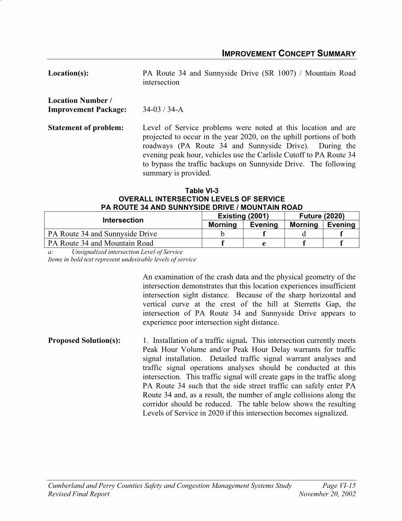
Cumberland and Perry Counties Safety and Congestion Management Systems Study Page VI-15
Revised Final Report November 20, 2002
IMPROVEMENT CONCEPT SUMMARY
Location(s): PA Route 34 and Sunnyside Drive (SR 1007) / Mountain Road intersection
Location Number /
Improvement Package: 34-03 / 34-A
Statement of problem: Level of Service problems were noted at this location and are projected to occur in the year 2020, on the uphill portions of both roadways (PA Route 34 and Sunnyside Drive). During the evening peak hour, vehicles use the Carlisle Cutoff to PA Route 34 to bypass the traffic backups on Sunnyside Drive. The following summary is provided.
Table VI-3
OVERALL INTERSECTION LEVELS OF SERVICE PA ROUTE 34 AND SUNNYSIDE DRIVE / MOUNTAIN ROAD
Existing (2001) Future (2020) Intersection
Morning Evening Morning Evening
PA Route 34 and Sunnyside Drive b f d f
PA Route 34 and Mountain Road f e f f a: Unsignalized intersection Level of Service Items in bold text represent undesirable levels of service
An examination of the crash data and the physical geometry of the
intersection demonstrates that this location experiences insufficient intersection sight distance. Because of the sharp horizontal and vertical curve at the crest of the hill at Sterretts Gap, the intersection of PA Route 34 and Sunnyside Drive appears to experience poor intersection sight distance.
Proposed Solution(s): 1. Installation of a traffic signal. This intersection currently meets
Peak Hour Volume and/or Peak Hour Delay warrants for traffic signal installation. Detailed traffic signal warrant analyses and traffic signal operations analyses should be conducted at this intersection. This traffic signal will create gaps in the traffic along PA Route 34 such that the side street traffic can safely enter PA Route 34 and, as a result, the number of angle collisions along the corridor should be reduced. The table below shows the resulting Levels of Service in 2020 if this intersection becomes signalized.
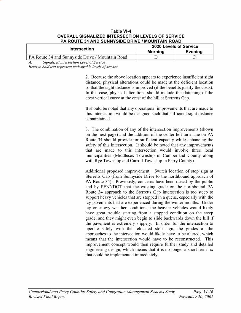
Cumberland and Perry Counties Safety and Congestion Management Systems Study Page VI-16
Revised Final Report November 20, 2002
Table VI-4 OVERALL SIGNALIZED INTERSECTION LEVELS OF SERVICE
PA ROUTE 34 AND SUNNYSIDE DRIVE / MOUNTAIN ROAD
2020 Levels of Service Intersection
Morning Evening
PA Route 34 and Sunnyside Drive / Mountain Road D C A: Signalized intersection Level of Service
Items in bold text represent undesirable levels of service
2. Because the above location appears to experience insufficient sight
distance, physical alterations could be made at the deficient location so that the sight distance is improved (if the benefits justify the costs). In this case, physical alterations should include the flattening of the crest vertical curve at the crest of the hill at Sterretts Gap.
It should be noted that any operational improvements that are made to
this intersection would be designed such that sufficient sight distance is maintained.
3. The combination of any of the intersection improvements (shown
on the next page) and the addition of the center left-turn lane on PA Route 34 should provide for sufficient capacity while enhancing the safety of this intersection. It should be noted that any improvements that are made to this intersection would involve three local municipalities (Middlesex Township in Cumberland County along with Rye Township and Carroll Township in Perry County).
Additional proposed improvement: Switch location of stop sign at Sterretts Gap (from Sunnyside Drive to the northbound approach of PA Route 34). Previously, concerns have been raised by the public and by PENNDOT that the existing grade on the northbound PA Route 34 approach to the Sterretts Gap intersection is too steep to support heavy vehicles that are stopped in a queue, especially with the icy pavements that are experienced during the winter months. Under icy or snowy weather conditions, the heavier vehicles would likely have great trouble starting from a stopped condition on the steep grade, and they might even begin to slide backwards down the hill if the pavement is extremely slippery. In order for the intersection to operate safely with the relocated stop sign, the grades of the approaches to the intersection would likely have to be altered, which means that the intersection would have to be reconstructed. This improvement concept would then require further study and detailed engineering design, which means that it is no longer a short-term fix that could be implemented immediately.

Cumberland and Perry Counties Safety and Congestion Management Systems Study Page VI-17
Revised Final Report November 20, 2002
FIGURE
Preliminary Proposed ImprovementsSterretts Gap - Intersection of PA Route 34 and Sunnyside Drive (SR 1007)Safety and Congestion Management System StudyCUMBERLAND AND PERRY COUNTIES, PENNSYLVANIA
34
34
MOUNTAIN
RD
SUNNYSIDE DRIVE (SR 1007)
34
MOUNTA
IN R
D
SUNNYSID
E DRIVE (SR
1007)
STOP
STOP
STOP
STOP
34
34
MOUNTAIN
RD
SUN
NYSIDE D
RIVE (SR 1007)
STOP
34
YIELD
Public Comment: 1. Approximately 65 percent of persons surveyed who attended the January Public Meetings identified traffic signals as an effective measure.
2. No specific response (either positive or negative) was received
from the public on this concept. 3. Public concern was expressed over Option A and the stopping
of vehicles on northbound SR 34 (especially any heavy vehicles). Approx. Cost Estimate: 1. This improvement concept would include limited safety
improvements at the intersection. - $1.1 million 2. $1.0 million 3. $2.5 million (Option A)\$5.1 million (Option B)

Cumberland and Perry Counties Safety and Congestion Management Systems Study Page VI-18
Revised Final Report November 20, 2002
IMPROVEMENT CONCEPT SUMMARY Location(s): PA Route 34 and PA Route 850 intersection (Shermans Dale) Location Number /
Improvement Package: 34-04 / 34-A
Statement of problem: Level of Service and congestion problems associated with the numerous conflicting turning movements with the adjacent shopping center driveway were noted and are projected at this location. The following summary is provided.
Table VI-5
OVERALL INTERSECTION LEVELS OF SERVICE PA ROUTE 34 AND PA ROUTE 850 (Shermans Dale)
Existing (2001) Future (2020) Intersection
Morning Evening Morning Evening
PA Route 34 and PA Route 850 (Shermans Dale) f f f f a: Unsignalized intersection Level of Service
Items in bold text represent undesirable levels of service
An examination of the crash data and the physical geometry of the intersection demonstrates that this location experiences insufficient intersection sight distance. The westbound approach of PA Route 850 has poor sight distance looking toward the south as seen in the following photo.
Photo of the view from the westbound approach of PA Route 850
looking southbound on PA Route 34

Cumberland and Perry Counties Safety and Congestion Management Systems Study Page VI-19
Revised Final Report November 20, 2002
Proposed Solution(s): 1. Installation of a traffic signal. This intersection currently meets Peak Hour Volume and/or Peak Hour Delay warrants for traffic signal installation. Detailed traffic signal warrant analyses and traffic signal operations analyses should be conducted at this intersection. This traffic signal will create gaps in the traffic along PA Route 34 such that the side street traffic can safely enter PA Route 34 and, as a result, the number of angle collisions along the corridor should be reduced. The table below shows the resulting Levels of Service in 2020 if this intersection becomes signalized.
Table VI-6
OVERALL SIGNALIZED INTERSECTION LEVELS OF SERVICE PA ROUTE 34 AND PA ROUTE 850 (Shermans Dale)
2020 Levels of Service Intersection
Morning Evening
PA Route 34 and PA Route 850 (Shermans Dale) B B A: Signalized intersection Level of Service
Items in bold text represent undesirable levels of service
2. Because the above location appears to experience insufficient
sight distance, physical alterations could be made at the deficient location so that the sight distance is improved (if the benefits justify the costs). In this case, physical alterations should include cutting back of the embankment on the southwest corner of the intersection.
A less expensive solution to the sight distance problem would be to install a traffic signal at this location.
3. Implementation of access management strategies. The
shopping center driveway immediately north of PA Route 850 should be reconfigured to a right-turn in/right-turn out only driveway. Left-turn movements into and out of the shopping center would then be made via the access driveway on PA Route 850. This will increase the traffic volume on PA Route 850, but reducing the number of conflicting turning movements will enhance the overall safety of the intersection. The four-legged intersection could be signalized if the future traffic volumes satisfy traffic signal warrants.

Cumberland and Perry Counties Safety and Congestion Management Systems Study Page VI-20
Revised Final Report November 20, 2002
FIGURE
Preliminary Proposed ImprovementsSouthern Intersection of PA Route 34 and PA Route 850 (Shermans Dale)Safety and Congestion Management System StudyCUMBERLAND AND PERRY COUNTIES, PENNSYLVANIA
EXISTING PROPOSED
PISGAH STATE ROAD
ShoppingCenterSTOP
STOP
34 850
34
850
ShoppingCenterSTOP
STOP
Traffic Signal
34
850
34 850
PISGAH STATE ROAD
TwinKiss
TwinKiss
Technical Committee
Comment: The southern shopping center driveway, which intersects with PA Route 850, should be reconstructed as far as possible to the east to lessen the probability of queuing problems associated with a new traffic signal. The distance between the southern shopping center driveway and PA Route 34 should be maximized to allow for the greatest amount queue storage within the back-to-back left-turn lanes.
Problems and confusion with right-turning vehicles into the northern shopping center driveway currently exist. The confusion occurs when the northbound motorists that wish to turn into the northern shopping center driveway from PA Route 34 have their right-turn signal on as they approach the PA Route 850 intersection, which is located immediately to the south of the shopping center driveway. The motorists wishing to enter PA Route 34 from the westbound PA Route 850 cross the northbound PA Route 34 traffic stream believing that the shopping center-bound motorists are making a right turn onto PA Route 850 eastbound. The northern shopping center driveway, which intersects with PA Route 34, should be closed, or, at a minimum, the driveway should be relocated as far as possible to the north to reduce the possibility of confusion.
Cumberland and Perry Counties Safety and Congestion Management Systems Study Page VI-21
Revised Final Report November 20, 2002
Public Comment: 1. Approximately 65 percent of persons surveyed who attended the January Public Meetings identified traffic signals as an effective measure.
2. No specific response (either positive or negative) was received
from the public on this concept. 3. Same comments as number one above. Approx. Cost Estimate: 1. This improvement concept would include limited safety
improvements at the intersection - $95,000 2. $125,000 3. This improvement concept would include signalization and
other limited safety improvements at the intersection =
$700,000

Cumberland and Perry Counties Safety and Congestion Management Systems Study Page VI-22
Revised Final Report November 20, 2002
IMPROVEMENT CONCEPT SUMMARY Location(s): PA Route 34 and Windy Hill Road (SR 2001) intersection Location Number /
Improvement Package: 34-02 / 34-A Statement of problem: Level of Service problems were noted and are projected at this
location, and the following summary is provided.
Table VI-7
OVERALL INTERSECTION LEVELS OF SERVICE PA ROUTE 34 AND WINDY HILL ROAD
Existing (2001) Future (2020) Intersection
Morning Evening Morning Evening
PA Route 34 and Windy Hill Road f e f f a: Unsignalized intersection Level of Service
Items in bold text represent undesirable levels of service
An examination of the crash data and the physical geometry of the
intersection demonstrates that this location experiences insufficient intersection sight distance. The southbound approach of SR 2001 experiences poor sight distance because of houses next to the roadway and the horizontal curvature of the roadway adjacent to the intersection as shown in the photo below.
Proposed Solution(s): 1. Installation of a traffic signal. This intersection currently meets
Peak Hour Volume and/or Peak Hour Delay warrants for traffic signal installation. Detailed traffic signal warrant analyses and traffic signal operations analyses should be conducted at this
Photo of the view from the westbound approach of Windy Hill Road looking northbound on PA Route 34
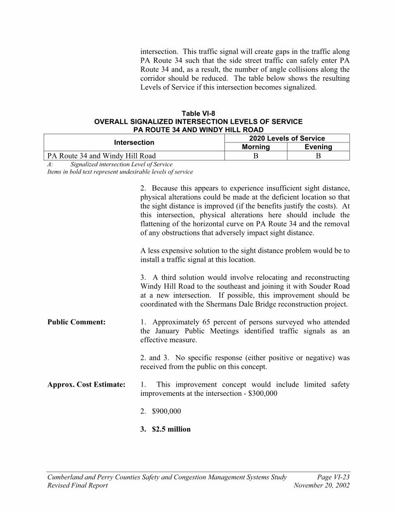
Cumberland and Perry Counties Safety and Congestion Management Systems Study Page VI-23
Revised Final Report November 20, 2002
intersection. This traffic signal will create gaps in the traffic along PA Route 34 such that the side street traffic can safely enter PA Route 34 and, as a result, the number of angle collisions along the corridor should be reduced. The table below shows the resulting Levels of Service if this intersection becomes signalized.
Table VI-8 OVERALL SIGNALIZED INTERSECTION LEVELS OF SERVICE
PA ROUTE 34 AND WINDY HILL ROAD
2020 Levels of Service Intersection
Morning Evening
PA Route 34 and Windy Hill Road B B A: Signalized intersection Level of Service
Items in bold text represent undesirable levels of service
2. Because this appears to experience insufficient sight distance, physical alterations could be made at the deficient location so that the sight distance is improved (if the benefits justify the costs). At this intersection, physical alterations here should include the flattening of the horizontal curve on PA Route 34 and the removal of any obstructions that adversely impact sight distance.
A less expensive solution to the sight distance problem would be to install a traffic signal at this location.
3. A third solution would involve relocating and reconstructing
Windy Hill Road to the southeast and joining it with Souder Road at a new intersection. If possible, this improvement should be coordinated with the Shermans Dale Bridge reconstruction project.
Public Comment: 1. Approximately 65 percent of persons surveyed who attended
the January Public Meetings identified traffic signals as an effective measure.
2. and 3. No specific response (either positive or negative) was
received from the public on this concept. Approx. Cost Estimate: 1. This improvement concept would include limited safety
improvements at the intersection - $300,000
2. $900,000
3. $2.5 million

Cumberland and Perry Counties Safety and Congestion Management Systems Study Page VI-24
Revised Final Report November 20, 2002
IMPROVEMENT CONCEPT SUMMARY Location(s): PA Route 34 and Fox Hollow Road intersection Location Number /
Improvement Package: 34-05 / 34-A
Statement of problem: Level of Service problems were noted and are projected at this location, and the following summary is provided.
Table VI-9 OVERALL INTERSECTION LEVELS OF SERVICE
PA ROUTE 34 AND FOX HOLLOW ROAD
Existing (2001) Future (2020) Intersection
Morning Evening Morning Evening
PA Route 34 and Fox Hollow Road f d f f a: Unsignalized intersection Level of Service Items in bold text represent undesirable levels of service
An examination of the crash data and the traffic count data
demonstrates that high numbers of rear-end crashes occur at this location due to a high number of left-turning vehicles.
Proposed Solution(s): 1. Installation of a traffic signal. This intersection currently meets
Peak Hour Volume and/or Peak Hour Delay warrants for traffic signal installation. Detailed traffic signal warrant analyses and traffic signal operations analyses should be conducted at this intersection. This traffic signal will create gaps in the traffic along PA Route 34 such that the side street traffic can safely enter PA Route 34 and, as a result, the number of angle collisions along the corridor should be reduced. The table below shows the resulting Levels of Service if this intersection becomes signalized.
Table VI-10
OVERALL SIGNALIZED INTERSECTION LEVELS OF SERVICE PA ROUTE 34 AND FOX HOLLOW ROAD
2020 Levels of Service Intersection
Morning Evening
PA Route 34 and Fox Hollow Road D D A: Signalized intersection Level of Service
Items in bold text represent undesirable levels of service
2. Construction of a separate left-turn lane at this location would
lessen the probability of rear-end crashes while enhancing the safety and lessening delays experienced by motorists on PA Route 34.

Cumberland and Perry Counties Safety and Congestion Management Systems Study Page VI-25
Revised Final Report November 20, 2002
Public Comment: 1. Approximately 65 percent of persons surveyed who attended the January Public Meetings identified traffic signals as an effective measure.
2. No specific response (either positive or negative) was received
from the public on this concept. Approx. Cost Estimate: 1. This improvement concept would include limited safety
improvements at the intersection - $80,000
2. This improvement concept (install a northbound left-turn
lane) does not include signalization - $185,000

Cumberland and Perry Counties Safety and Congestion Management Systems Study Page VI-26
Revised Final Report November 20, 2002
IMPROVEMENT CONCEPT SUMMARY Location(s): PA Route 34 and Richwine Road/Young’s Church Road
intersection Location Number /
Improvement Package: 34-13 / 34-A
Statement of problem: Level of Service problems were noted and are projected at this location, and the following summary is provided.
Table VI-11
OVERALL INTERSECTION LEVELS OF SERVICE PA ROUTE 34 AND RICHWINE / YOUNG’S CHURCH ROAD
Existing (2001) Future (2020) Intersection
Morning Evening Morning Evening
PA Route 34 and Richwine / Young’s Church Rd e d f f a: Unsignalized intersection Level of Service
Items in bold text represent undesirable levels of service
An examination of the crash data and the traffic count data
demonstrates that high numbers of rear-end crashes occur at this location due to a high number of left-turning vehicles.
Proposed Solution(s): 1. Installation of a traffic signal. This intersection currently meets
Peak Hour Volume and/or Peak Hour Delay warrants for traffic signal installation. Detailed traffic signal warrant analyses and traffic signal operations analyses should be conducted at this intersection. This traffic signal will create gaps in the traffic along PA Route 34 such that the side street traffic can safely enter PA Route 34 and, as a result, the number of angle collisions along the corridor should be reduced. The table below shows the resulting Levels of Service if this intersection becomes signalized.
Table VI-12
OVERALL SIGNALIZED INTERSECTION LEVELS OF SERVICE PA ROUTE 34 AND RICHWINE / YOUNG’S CHURCH ROAD
2020 Levels of Service Intersection
Morning Evening
PA Route 34 and Richwine / Young’s Church Road B B A: Signalized intersection Level of Service
Items in bold text represent undesirable levels of service
The installation of all traffic signals proposed on PA Route 34
would definitely cause the currently unimpeded through movements on PA Route 34 to experience some delays at the
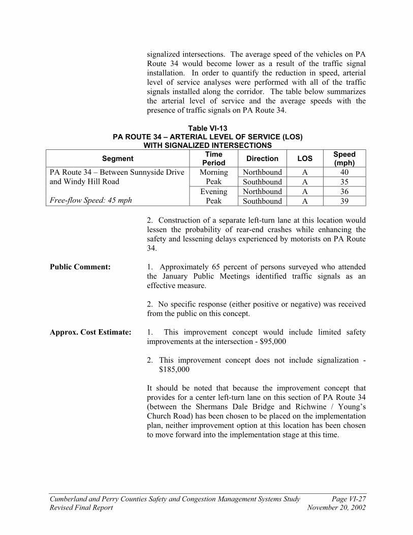
Cumberland and Perry Counties Safety and Congestion Management Systems Study Page VI-27
Revised Final Report November 20, 2002
signalized intersections. The average speed of the vehicles on PA Route 34 would become lower as a result of the traffic signal installation. In order to quantify the reduction in speed, arterial level of service analyses were performed with all of the traffic signals installed along the corridor. The table below summarizes the arterial level of service and the average speeds with the presence of traffic signals on PA Route 34.
Table VI-13
PA ROUTE 34 – ARTERIAL LEVEL OF SERVICE (LOS) WITH SIGNALIZED INTERSECTIONS
Segment Time
Period Direction LOS
Speed (mph)
Northbound A 40 Morning Peak Southbound A 35
Northbound A 36
PA Route 34 – Between Sunnyside Drive and Windy Hill Road Free-flow Speed: 45 mph
Evening Peak Southbound A 39
2. Construction of a separate left-turn lane at this location would
lessen the probability of rear-end crashes while enhancing the safety and lessening delays experienced by motorists on PA Route 34.
Public Comment: 1. Approximately 65 percent of persons surveyed who attended
the January Public Meetings identified traffic signals as an effective measure.
2. No specific response (either positive or negative) was received
from the public on this concept. Approx. Cost Estimate: 1. This improvement concept would include limited safety
improvements at the intersection - $95,000
2. This improvement concept does not include signalization - $185,000
It should be noted that because the improvement concept that provides for a center left-turn lane on this section of PA Route 34 (between the Shermans Dale Bridge and Richwine / Young’s Church Road) has been chosen to be placed on the implementation plan, neither improvement option at this location has been chosen to move forward into the implementation stage at this time.

Cumberland and Perry Counties Safety and Congestion Management Systems Study Page VI-28
Revised Final Report November 20, 2002
IMPROVEMENT CONCEPT SUMMARY Location(s): PA Route 34 and Barnett Road intersection (southern) Location Number /
Improvement Package: 34-08 / 34-C Statement of problem: The horizontal curvature and vertical curvature on PA Route 34
south of the intersection are severe enough to cause sight distance problems for motorists on the southbound approach of Barnett Road.
Proposed Solution(s): Because the above location appears to experience insufficient sight distance, alterations could be made at the deficient location so that the sight distance is improved (if the benefits justify the costs). A solution would involve physical alterations including the flattening of the vertical and horizontal curves near the intersection.
Technical Committee
Comment: A very narrow bridge currently exists on Barnett Road north of the PA Route 34 intersection. If this bridge is improved, the traffic that uses Barnett Road as a shortcut around the center of New Bloomfield will likely increase in volume. The increase in traffic volume in combination with the existing sight distance problem further demonstrates the need for improvements at this intersection.
Public Comment: No specific response (either positive or negative) was received from the public on this concept.
Approx. Cost Estimate: $400,000

Cumberland and Perry Counties Safety and Congestion Management Systems Study Page VI-29
Revised Final Report November 20, 2002
IMPROVEMENT CONCEPT SUMMARY Location(s): PA Route 34 and Shortcut Road (SR 1017) intersection PA Route 34 and Juniata Parkway (SR 1015) intersection Location Number /
Improvement Package: 34-09, 34-10 / 34-D
Statement of problem: An examination of the crash data and the physical geometry of the intersection demonstrates that both of these locations experience insufficient intersection sight distance. Obstructions close to the roadway are the cause of the poor sight distance that are experienced at these locations. The bridge truss that is located immediately south of the Juniata Parkway intersection blocks the view for motorists on Juniata Parkway. At the Shortcut Road intersection, the embankment that is close to the roadway obstructs the sight distance as shown in the photo below.
Proposed Solution(s): Because the above locations appear to experience insufficient sight distance, alterations could be made at the deficient locations so that the sight distance is improved (if the benefits justify the costs). At these intersections, physical alterations should include the cutting back of the embankment at Shortcut Road or the modification of the structure at Juniata Parkway.
Public Comment: No specific response (either positive or negative) was received from the public on this concept.
Approx. Cost Estimate: $57,000 (SR 34 and Shortcut Road)
$180,000 (SR 34 and Juniata Parkway)
Photo of the view from the northbound approach of Shortcut
Road looking southbound on PA Route 34

Cumberland and Perry Counties Safety and Congestion Management Systems Study Page VI-30
Revised Final Report November 20, 2002
IMPROVEMENT CONCEPT SUMMARY Location(s): PA Route 34 / Dellville Road (SR 2002) / SR 2006 intersection (Southern Mecks Corner Intersection) Location Number /
Improvement Package: 34-06 / 34-C
Statement of problem: This intersection consists of two stop-controlled intersections on the east side of PA Route 34. The current design of the intersection poses safety problems and is confusing to motorists.
Proposed Solution(s): This intersection should be re-striped or a more expensive solution would be to redesign the intersection as shown in the graphic below.
FIGURE
Preliminary Proposed ImprovementsIntersection of PA Route 34, Dellville Road (SR 2002), and SR 2006 (Mecks Corner)Safety and Congestion Management System StudyCUMBERLAND AND PERRY COUNTIES, PENNSYLVANIA
274
SR 2006
(to
EB)
34
34
(SR 2002)
DELLVILLE RO
AD
STOP
STOP
(to WB
)
274
(SR 2002)
DELLVILLE RO
AD
STOP
STOP
(to WB
)
274
SR 2006
(to
EB)
274
34
(SR
2002)
DE
LLVILLE
RO
AD
STOPSTOP
(to WB
)
274
(to
EB)
274
34
SR 2006
It should be noted that these improvements would be nullified and
superseded if the proposed improvements at Mecks Corner (three intersections) are implemented; please see the corresponding improvement concept summary on the next page of this chapter.
Public Comment: No specific response (either positive or negative) was received from the public on this concept.
Approx. Cost Estimate: $12,000 (Re-stripe intersection) $2.5 million (Reconstruct intersection)
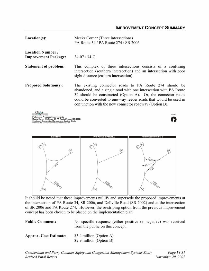
Cumberland and Perry Counties Safety and Congestion Management Systems Study Page VI-31
Revised Final Report November 20, 2002
IMPROVEMENT CONCEPT SUMMARY Location(s): Mecks Corner (Three intersections)
PA Route 34 / PA Route 274 / SR 2006 Location Number /
Improvement Package: 34-07 / 34-C
Statement of problem: This complex of three intersections consists of a confusing intersection (southern intersection) and an intersection with poor sight distance (eastern intersection).
Proposed Solution(s): The existing connector roads to PA Route 274 should be abandoned, and a single road with one intersection with PA Route 34 should be constructed (Option A). Or, the connector roads could be converted to one-way feeder roads that would be used in conjunction with the new connector roadway (Option B).
FIGURE
Preliminary Proposed ImprovementsMecks Corner (PA Route 34, PA Route 274, and SR 2002)Safety and Congestion Management System StudyCUMBERLAND AND PERRY COUNTIES, PENNSYLVANIA
SR 2006
34
(SR 2002)DELLVILLE ROAD
274
274
34
34
(SR 2002)DELLVILLE ROAD
274
274
34
34
(SR 2002)DELLVILLE ROAD
274
274
34
ONE WAY
ONE WAY
It should be noted that these improvements nullify and supersede the proposed improvements at the intersection of PA Route 34, SR 2006, and Dellville Road (SR 2002) and at the intersection of SR 2006 and PA Route 274. However, the re-striping option from the previous improvement concept has been chosen to be placed on the implementation plan.
Public Comment: No specific response (either positive or negative) was received from the public on this concept.
Approx. Cost Estimate: $3.4 million (Option A) $2.9 million (Option B)
Cumberland and Perry Counties Safety and Congestion Management Systems Study Page VI-32
Revised Final Report November 20, 2002
IMPROVEMENT CONCEPT SUMMARY Location(s): PA Route 34 and Rambo Hill Road intersection Location Number /
Improvement Package: 34-12 / 34-A
Statement of problem: An examination of the crash data and the traffic count data demonstrates that high numbers of rear-end crashes occur at this location due to a high number of left-turning vehicles.
Proposed Solution(s): Construction of a separate left-turn lane at this location would lessen the probability of rear-end crashes while enhancing the safety and lessening delays experienced by motorists on PA Route 34.
Public Comment: No specific response (either positive or negative) was received from the public on this concept.
Approx. Cost Estimate: $185,000 (SR 34 and Rambo Hill Road)

Cumberland and Perry Counties Safety and Congestion Management Systems Study Page VI-33
Revised Final Report November 20, 2002
IMPROVEMENT CONCEPT SUMMARY Location(s): PA Route 34 – (PA Route 274 to PA Route 944) Location Number /
Improvement Package: 34-14 / 34-E Statement of problem: An examination of the crash data, the traffic count data, and the
capacity analyses demonstrates that safety problems and congestion problems currently exist and are projected to exist along the PA Route 34 corridor.
Proposed Solution(s): A long-range improvement solution involves the construction of a new roadway corridor (Alternative A). The new roadway corridor would branch off from PA Route 34 near Mecks Corner (PA Route 274) then it would head southeast to intersect PA Route 850 at Millers Gap or Deans Gap before ending at either the PA Route 944 and PA Route 114 intersection or the Interstate 81 and PA Route 581 interchange.
Preliminary analysis of the proposed roadway shows diversion up to 600 vehicles during the morning peak hour and up to 800 vehicles during the evening peak hour. Total daily traffic estimates for the proposed roadway are approximately 8,000 vehicles per day. This traffic is diverted from southern sections of SR 34 and western sections of SR 944 as well as SR 850 (assuming an intersection between SR 850 and the proposed roadway). This reduction provides significant relief to the southern sections of SR 34 and western SR 944. The new roadway corridor draws traffic off of roadways to which they are parallel.
The construction of a new roadway will have minimal traffic
impacts to other roadway corridors in the study area in addition to PA Route 34. A new roadway would draw a small amount of traffic off of the other existing parallel corridors, but it would draw traffic to the roadway corridors that have an intersection with the new off-line alternative.
Public Comment: There as been generally favorable public response to this concept.
Approx. Cost Estimate: $260 million (New Roadway – Alternative A)

SR 1007 SUNNYSIDE DR
LAM
BS
GA
P
RO
AD
CARLISLECUTOFF
VALLEY ROAD
CA
RO
L
LAN
E
OR
RS
BR
IDG
E
RO
AD
EA
ST
PE
NN
DR
IVE
MA
GA
RO
RO
AD
RIC
H V
ALL
EY
RO
AD
DE
ER
LA
NE
11 15
81
944
944
944
581114
34
Photo 4
PA Route 944 - Locations of Proposed ImprovementsSafety and Congestion Management System StudyCUMBERLAND AND PERRY COUNTIES, PENNSYLVANIA
Legend944-01 - Improvement concept location code number
FIGURE
944-07 944-A
944-06 944-A
944-04 944-A
944-08 944-B
944-01 944-A
944-05 944-D
944-03 944-D
944-02 944-C
Legend 944-01 – Improvement concept location code number 944-A – Improvement package code number
The improvement packages and improvement concepts shown in italic boldface are placed on the Implementation Plan.
VI-2

Cumberland and Perry Counties Safety and Congestion Management Systems Study Page VI-35
Revised Final Report November 20, 2002
IMPROVEMENT CONCEPT SUMMARY
Location(s): PA Route 944 and PA Route 114 intersection
Location Number /
Improvement Package: 944-04 / 944-A
Statement of problem: Level of service problems were noted and are projected at this intersection, as summarized in the following table:
Table VI-14
OVERALL INTERSECTION LEVELS OF SERVICE PA ROUTE 944 AND PA ROUTE 114
Existing (2001) Future (2020) Intersection
Morning Evening Morning Evening
PA Route 944 and PA Route 114 C E C F A: Signalized intersection Level of Service, Items in bold text represent undesirable levels of service
An examination of the crash data and the physical geometry of the intersection demonstrates that this location experiences insufficient intersection sight distance. Left-turning vehicles on the westbound approach of PA Route 944 and the northbound approach of PA Route 114 experience limited sight distance when looking for gaps in oncoming traffic. Crash data shows that a high percentage of crashes that occurred at this location were angle collisions, which is indicative of poor sight distance and/or problems with the timing of the clearance periods of the traffic signal. This traffic signal has been installed at this locations recently, and it is possible that the aforementioned safety problems are not as severe.
Photo of the view from the westbound approach of PA Route 944 looking at its intersection with PA Route 114
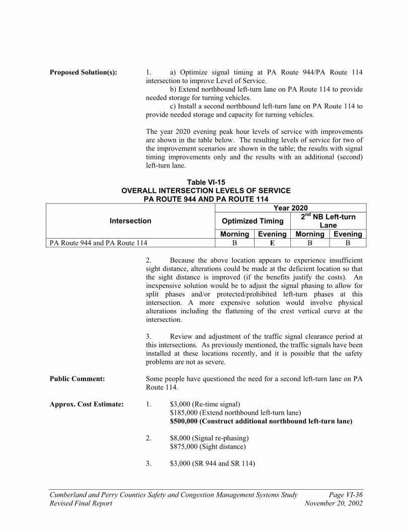
Cumberland and Perry Counties Safety and Congestion Management Systems Study Page VI-36
Revised Final Report November 20, 2002
Proposed Solution(s): 1. a) Optimize signal timing at PA Route 944/PA Route 114
intersection to improve Level of Service. b) Extend northbound left-turn lane on PA Route 114 to provide needed storage for turning vehicles. c) Install a second northbound left-turn lane on PA Route 114 to provide needed storage and capacity for turning vehicles.
The year 2020 evening peak hour levels of service with improvements are shown in the table below. The resulting levels of service for two of the improvement scenarios are shown in the table; the results with signal timing improvements only and the results with an additional (second) left-turn lane.
Table VI-15
OVERALL INTERSECTION LEVELS OF SERVICE PA ROUTE 944 AND PA ROUTE 114
Year 2020
Optimized Timing 2nd NB Left-turn
Lane Intersection
Morning Evening Morning Evening
PA Route 944 and PA Route 114 B E B B
2. Because the above location appears to experience insufficient sight distance, alterations could be made at the deficient location so that the sight distance is improved (if the benefits justify the costs). An inexpensive solution would be to adjust the signal phasing to allow for split phases and/or protected/prohibited left-turn phases at this intersection. A more expensive solution would involve physical alterations including the flattening of the crest vertical curve at the intersection.
3. Review and adjustment of the traffic signal clearance period at this intersections. As previously mentioned, the traffic signals have been installed at these locations recently, and it is possible that the safety problems are not as severe.
Public Comment: Some people have questioned the need for a second left-turn lane on PA Route 114.
Approx. Cost Estimate: 1. $3,000 (Re-time signal) $185,000 (Extend northbound left-turn lane)
$500,000 (Construct additional northbound left-turn lane)
2. $8,000 (Signal re-phasing) $875,000 (Sight distance)
3. $3,000 (SR 944 and SR 114)

Cumberland and Perry Counties Safety and Congestion Management Systems Study Page VI-37
Revised Final Report November 20, 2002
IMPROVEMENT CONCEPT SUMMARY Location(s): PA Route 944 and US Routes 11/15 intersection
Location Number /
Improvement Package: 944-03 / 944-D
Statement of problem: Level of service problems were noted on the eastbound PA Route 944 approach during the morning peak hour, as summarized in the following table:
Table VI-16
OVERALL INTERSECTION LEVELS OF SERVICE PA ROUTE 944 AND US ROUTES 11/15
Existing (2001) Future (2020) Intersection
Morning Evening Morning Evening
PA Route 944 and US Routes 11/15 f c f d a: Unsignalized intersection Level of Service
Items in bold text represent undesirable levels of service
Proposed Solution(s): Construct acceleration lane at the US Routes 11/15 southbound entrance point to improve Level of Service. With the addition of an acceleration lane, the intersection would be reconstructed to discourage illegal left-turns onto US Routes 11/15 Northbound. To allow for the acceleration lane, the access point to the Fourth Street area would be moved to the Fifth Street intersection with State Street (PA Route 944).
FIGURE
Preliminary Proposed ImprovementsIntersection of US Routes 11/15 and PA Route 944Safety and Congestion Management System StudyCUMBERLAND AND PERRY COUNTIES, PENNSYLVANIA
4TH S
TREET
5TH
STR
EE
T
STOP
4TH S
TREET
5TH
STR
EE
T
94411 15
94411 15
WEST STREET WEST STREET

Cumberland and Perry Counties Safety and Congestion Management Systems Study Page VI-38
Revised Final Report November 20, 2002
Install traffic signal Restripe and sign southbound approach of US Routes 11/15 at the
PA Route 944 intersection such that southbound vehicles (on US Routes 11/15) remain in the left-lane and motorists on eastbound PA Route 944 can safely merge with southbound US Routes 11/15 traffic.
Public Comment: The public response to the acceleration lane has not been favorable because access would be closed off to Fourth Street.
Approx. Cost Estimate: $1.4 million (construct acceleration lane) $80,000 (install traffic signal) $10,000 (Restripe and install new signs)
Cumberland and Perry Counties Safety and Congestion Management Systems Study Page VI-39
Revised Final Report November 20, 2002
IMPROVEMENT CONCEPT SUMMARY
Location(s): PA Route 944 between: Sunnyside Drive (SR 1007) and PA Route 114 Interstate 81 and East Penn Drive (SR 1015)
Location Number /
Improvement Package: 944-01 / 944-A (Sunnyside to PA 114) 944-02 / 944-C (I-81 to East Penn Drive)
Statement of problem: Mid-block level of service problems were noted and are expected on segments of PA Route 944 during the peak hour. By the year 2020, the segment of PA Route 944 between East Penn Drive and I-81 is expected to experience a mid-block Level of Service ‘E’, and the segment of PA 944 between Sunnyside Drive and PA 114 is expected to experience a mid-block Level of Service ‘F’ during the evening peak hour.
Proposed Solution(s): Construction of a two-way center left-turn lane, will improve
segment capacity and Level of Service. It should be noted that the existing sight distance problems at the
intersections along PA Route 944 would be mitigated by any roadway widening projects. As a result, the sight distance improvement concepts at the effected locations would be superseded by the widening improvement concept.
Please note that additional traffic counts should be conducted in
the future at the intersection of PA Route 944 and Sunnyside Drive. If the new traffic counts warrant the installation of a traffic signal, signal installation should occur. The new traffic signal at this location will create gaps in the traffic stream such that residents that live along PA Route 944 will be able to exit their driveways and access roadways with greater ease during the peak traffic periods in the future.
Public Comment: Generally negative public response due to potential residential impacts.
Approx. Cost Estimate: $14 million (Between Sunnyside Drive and PA Route 114)
$11 million (Between I-81 and East Penn Drive)

Cumberland and Perry Counties Safety and Congestion Management Systems Study Page VI-40
Revised Final Report November 20, 2002
IMPROVEMENT CONCEPT SUMMARY
Location(s): PA Route 944 and Magaro Road / Carol Lane intersection
Location Number /
Improvement Package: 944-05 / 944-D
Statement of problem: The offset intersection of PA Route 944 and Magaro Road / Carol Lane causes safety and delay problems for motorists. Rapid development occurring in the area will increase traffic volumes and the associated delays and safety problems. Photos of the intersection are shown below:
Proposed Solution(s): Implement an access management strategy involving the realignment of the three-leg unsignalized intersections of PA Route 944 with Magaro Road / Carol Lane into a four-leg intersection. The new four-leg intersection could be signalized if the future traffic volumes satisfy traffic signal warrants. Examine the feasibility of the reduction / combination of driveway locations along the entire PA Route 944 corridor.
Public Comment: No specific response (either positive or negative) was received from the public on this concept.
Approx. Cost Estimate: $750,000
Photo of the offset intersection of PA Route 944 and Magaro Road / Carol Lane
Photo of the offset intersection of PA Route 944 and Magaro Road / Carol Lane
Cumberland and Perry Counties Safety and Congestion Management Systems Study Page VI-41
Revised Final Report November 20, 2002
IMPROVEMENT CONCEPT SUMMARY
Location(s): PA Route 944 and Rich Valley Road intersection Location Number /
Improvement Package: 944-06 / 944-A
Statement of problem: An examination of the crash data and the physical geometry of the intersection demonstrates that this location experiences insufficient intersection sight distance. The northbound and southbound approaches of Rich Valley Road appear to have insufficient sight distance.
Proposed Solution(s): Because the above location appears to experience insufficient sight
distance, physical alterations could be made at the deficient location such that the sight distance is improved (if the benefits justify the costs). In this case, physical alterations should include the flattening of the crest vertical curve on PA Route 944 immediately west of Rich Valley Road.
Public Comment: No specific response (either positive or negative) was received from the public on this concept.
Approx. Cost Estimate: $500,000 This cost for this improvement package is not in boldface because
it will be implemented along with the widening of PA Route 944 to three lanes between Sunnyside Drive and PA Route 114.

Cumberland and Perry Counties Safety and Congestion Management Systems Study Page VI-42
Revised Final Report November 20, 2002
IMPROVEMENT CONCEPT SUMMARY Location(s): PA Route 944 and Deer Lane intersection Location Number /
Improvement Package: 944-07 / 944-A
Statement of problem: An examination of the crash data and the physical geometry of the intersection demonstrates that this location experiences insufficient intersection sight distance. All approaches of Deer Lane and PA Route 944 appear to have insufficient sight distance because of the extremely sharp vertical curve at the crest of the hill at this intersection. Photos of the intersection of Deer Lane and PA Route 944 are shown below.
Proposed Solution(s): Because the above location appears to experience insufficient sight distance, physical alterations could be made at the deficient location such that the sight distance is improved (if the benefits justify the costs). In this case, physical alterations should include the flattening of the crest vertical curve while maintaining sufficient access to Deer Lane.
Public Comment: Improvement at this location was supported by the public at the January Public Meetings.
Approx. Cost Estimate: $800,000 This cost for this improvement package is not in boldface because
it will be implemented along with the widening of PA Route 944 to three lanes between Sunnyside Drive and PA Route 114.
Looking east at the intersection of PA Route 944 and Deer Lane, which is located
at the crest of the hill
Photo of the view from the northbound approach of Deer Lane looking westbound
on PA Route 944

Cumberland and Perry Counties Safety and Congestion Management Systems Study Page VI-43
Revised Final Report November 20, 2002
IMPROVEMENT CONCEPT SUMMARY Location(s): PA Route 944 and Lambs Gap Road (SR 1011) intersection Location Number /
Improvement Package: 944-08 / 944-B
Statement of problem: An examination of the crash data and the physical geometry of the intersection demonstrates that this location experiences insufficient intersection sight distance. The northbound and southbound approaches of Lambs Gap Road appear to have insufficient sight distance.
Proposed Solution(s): Because the above location appears to experience insufficient sight distance, physical alterations could be made at the deficient location so that the sight distance is improved (if the benefits justify the costs). The sight distance problems experienced at the Lambs Gap Road intersection are similar to those experienced at the Rich Valley Road intersection. Similarly, physical alterations here should also include the flattening of the crest vertical curve on PA Route 944 immediately west of Lambs Gap Road. It should be noted that the existing traffic volumes at this intersection do not meet traffic signal warrants.
Public Comment: No specific response (either positive or negative) was received from the public on this concept.
Approx. Cost Estimate: $580,000
Photo of the view from the northbound approach of Lambs Gap Road looking
westbound on PA Route 944
Legend11-01 - Improvement concept location code number
FIGURE
US Routes 11/15 - Locations of Proposed ImprovementsSafety and Congestion Management System StudyCUMBERLAND AND PERRY COUNTIES, PENNSYLVANIA
Susquehanna River
81
11
11
11
22
849
274
850
944
581
SH
EE
TZ
SU
SQ
UE
NIT
AS
CH
OO
L C
OM
PLE
X
SHADY
LANE
RO
HR
ER
11-09 11-E
11-02 11-A
11-04 11-F
11-01 11-A
11-05 11-A
11-03 11-A
11-12 11-F
11-06 11-B
11-08 11-B
11-10 11-A
11-07 11-A
Legend 11-01 – Improvement concept location code number 11-A – Improvement package code number
The improvement packages and improvement concepts shown in italic boldface are placed on the Implementation Plan.
VI-3
11-01 11-H

Cumberland and Perry Counties Safety and Congestion Management Systems Study Page VI-45
Revised Final Report November 20, 2002
IMPROVEMENT CONCEPT SUMMARY
Location(s): US Routes 11/15 and PA Route 850 intersection Location Number /
Improvement Package: 11-03 / 11-A
Statement of problem: Level of service problems were noted and are projected on US Routes 11/15 at the intersection listed above; the following summary is provided:
Table VI-17
OVERALL INTERSECTION LEVELS OF SERVICE US ROUTES 11/15 AND PA ROUTE 850
Existing (2001) Future (2020) Intersection
Morning Evening Morning Evening
US Routes 11/15 and PA Route 850 f d f f a: Unsignalized intersection Level of Service Items in bold text represent undesirable levels of service
The capacity analysis software does not allow for the modeling of the conditions that currently exist during the morning peak hour on southbound US Routes 11/15 in the Marysville area. Motorists traveling in the heavy morning traffic on southbound US Routes 11/15 slow down to allow vehicles from PA Route 850 and the other roadways in Marysville to enter the southbound traffic stream. When this occurs, motorists upstream on southbound US Routes 11/15 experience delays that are not modeled or shown in the results of the capacity analysis. The photo on the next page illustrates the dynamic operation of the intersection of US Routes 11/15 and PA Route 850 during the morning peak hour.
An examination of the crash data and the physical geometry of the intersection demonstrates that this location experiences insufficient intersection sight distance. The eastbound approach of PA Route 850 has poor sight distance looking toward the north because of the structures and signs that block the view from the intersection (as seen in the following photo) and the parked vehicles along the southbound side of US Routes 11/15 north of the intersection. This intersection also has extremely tight turning radii that cause problems for trucks and other large vehicles that desire to turn at the intersection.

Cumberland and Perry Counties Safety and Congestion Management Systems Study Page VI-46
Revised Final Report November 20, 2002
Proposed Solution(s): 1. Installation of a traffic signal. This intersection along US
Routes 11/15 currently meets Peak Hour Volume and/or Peak Hour Delay warrants for traffic signal installation. Detailed traffic signal warrant analyses and traffic signal operations analyses should be conducted at this intersection. The traffic signal will create gaps in the traffic on US Routes 11/15 such that the side street traffic can safely enter US Routes 11/15 and, as a result, the number of angle collisions along the corridor should be reduced. Flashing signals should be considered at locations where the traffic volume over the course of the entire day does not warrant traffic signal installation. The table on the next page shows the resulting intersection Levels of Service on US Routes 11/15 in year 2020 if the intersection becomes signalized. The eastbound approach of
Photo of the view looking south on US Routes 11/15 at the PA Route 850 intersection
Photo of the view from the eastbound approach of PA Route 850 looking northbound on US Routes 11/15
Cumberland and Perry Counties Safety and Congestion Management Systems Study Page VI-47
Revised Final Report November 20, 2002
PA Route 850 at its intersection with US Routes 11/15 will need to be widened to include separate left-turn and right-turn lanes in order for the signalized intersection to operate at desirable levels of service.
Table VI-18
OVERALL SIGNALIZED INTERSECTION LEVELS OF SERVICE US ROUTES 11/15 AND PA ROUTE 850
2020 Levels of Service Intersection
Morning Evening
US Routes 11/15 and PA Route 850 C B A: Signalized intersection Level of Service
Items in bold text represent undesirable levels of service
2. Sight distance problems are evident at this intersection. Physical alterations should include removal of the structure and any other objects that block the view from the intersection.
The construction of an acceleration lane from eastbound PA Route
850 to southbound US Routes 11/15 would enhance the safety and also decrease delays at this location.
Public Comment: 1. Half of the persons surveyed at the January public meetings
indicated that traffic signals would be an effective solution. 2. No specific response (either positive or negative) was received
from the public on this concept. Approx. Cost Estimate: 1. This improvement concept would address some of the safety
problems and would include an additional eastbound right-turn lane at the intersection. - $400,000
2. Addresses most safety concerns
$310,000 (removal of obstructions) $1.05 million (construction of acceleration lane)

Cumberland and Perry Counties Safety and Congestion Management Systems Study Page VI-48
Revised Final Report November 20, 2002
IMPROVEMENT CONCEPT SUMMARY Location(s): US Routes 11/15 and the Sheetz/Rohrer Bus Driveway intersection Location Number /
Improvement Package: 11-05 / 11-A
Statement of problem: Level of service problems were noted and are projected on US Routes 11/15 at the intersection listed above; the following summary is provided:
Table VI-19 OVERALL INTERSECTION LEVELS OF SERVICE
US ROUTES 11/15 AND SHEETZ / ROHRER DRIVEWAY
Existing (2001) Future (2020) Intersection
Morning Evening Morning Evening
US Routes 11/15 and Sheetz / Rohrer Driveway f f f f
a: Unsignalized intersection Level of Service
Items in bold text represent undesirable levels of service
An examination of the crash data and the traffic count data demonstrates that high number of rear-end crashes (non-reportable and reportable) occurs at this location due to a high number of right-turning vehicles.
Photo of the view from the northbound approach of US Routes 11/15 looking northbound at the Sheetz / Rohrer Driveway

Cumberland and Perry Counties Safety and Congestion Management Systems Study Page VI-49
Revised Final Report November 20, 2002
Proposed Solution(s): 1. Installation of a traffic signal. This intersection along US Routes
11/15 currently meets Peak Hour Volume and/or Peak Hour Delay warrants for traffic signal installation. Detailed traffic signal warrant analyses and traffic signal operations analyses should be conducted at this intersection. The traffic signals will create gaps in the traffic on US Routes 11/15 such that the side street traffic can safely enter US Routes 11/15 and, as a result, the number of angle collisions along the corridor should be reduced. Flashing signals should be considered at locations where the traffic volume over the course of the entire day does not warrant traffic signal installation. The table on the next page shows the resulting intersection Levels of Service on US Routes 11/15 if the intersection becomes signalized. It should be noted that the Sheetz/Rohrer Driveway is a private driveway.
Table VI-20 OVERALL SIGNALIZED INTERSECTION LEVELS OF SERVICE
US ROUTES 11/15 AND PA ROUTE 850
2020 Levels of Service Intersection
Morning Evening
US Routes 11/15 and Sheetz / Rohrer Driveway B B
A: Signalized intersection Level of Service
Items in bold text represent undesirable levels of service
2. Construction of a separate right-turn lane at this location would lessen the probability of rear-end crashes while enhancing the safety and lessening delays experienced by motorists on US Routes 11/15.
Additionally, the continuous center left-turn lane should be extended
farther to the south on US Routes 11/15 to ensure a smoother transition from the two-lane section (immediately south of this location) to the three-lane section.
Public Comment: 1. Half of the persons surveyed at the January public meetings indicated
that traffic signals would be an effective solution.
2. No specific response (either positive or negative) was received from the public on this concept.
Approx. Cost Estimate: 1. This improvement concept would include some safety improvements
at the intersection and an additional right-turn lane. - $185,000
2. Estimates do not include signalization of intersection $90,000 (Northbound right-turn lane)
$2,500 (Extend center-turn lane by repainting) $140,000 (Extend center-turn lane by widening roadway)

Cumberland and Perry Counties Safety and Congestion Management Systems Study Page VI-50
Revised Final Report November 20, 2002
IMPROVEMENT CONCEPT SUMMARY
Location(s): US Routes 11/15 and the Susquenita High School driveway
Location Number /
Improvement Package: 11-02 / 11-A Statement of problem: Level of service problems were noted and are projected on US
Routes 11/15 at the locations listed above; the following summary is provided:
Table VI-21
OVERALL INTERSECTION LEVELS OF SERVICE US ROUTES 11/15 AND THE SUSQUENITA HIGH SCHOOL DRIVEWAY
Existing (2001) Future (2020) Intersection
Morning Evening Morning Evening
US Routes 11/15 and Susquenita High School Drive
e e f f
a: Unsignalized intersection Level of Service
Items in bold text represent undesirable levels of service
Proposed Solution(s): Installation of traffic signals. These intersections along US Routes 11/15 currently meet Peak Hour Volume and/or Peak Hour Delay warrants for traffic signal installation. Detailed traffic signal warrant analyses and traffic signal operations analyses should be conducted at these two intersections. The traffic signals will create gaps in the traffic on US Routes 11/15 such that the side street traffic can safely enter US Routes 11/15 and, as a result, the number of angle collisions along the corridor should be reduced. Flashing signals should be considered at locations where the traffic volume over the course of the entire day does not warrant traffic signal installation. The table on the next page shows the resulting intersection Levels of Service on US Routes 11/15 if the intersections become signalized.
Table VI-22
OVERALL SIGNALIZED INTERSECTION LEVELS OF SERVICE US ROUTES 11/15 AND THE SUSQUENITA HIGH SCHOOL DRIVEWAY
2020 Levels of Service Intersection
Morning Evening
US Routes 11/15 and Susquenita High School Drive B B A: Signalized intersection Level of Service
Items in bold text represent undesirable levels of service
The installation of all traffic signals proposed on US Routes 11/15 would definitely cause the currently unimpeded through movements on US Routes 11/15 to experience some delays at the
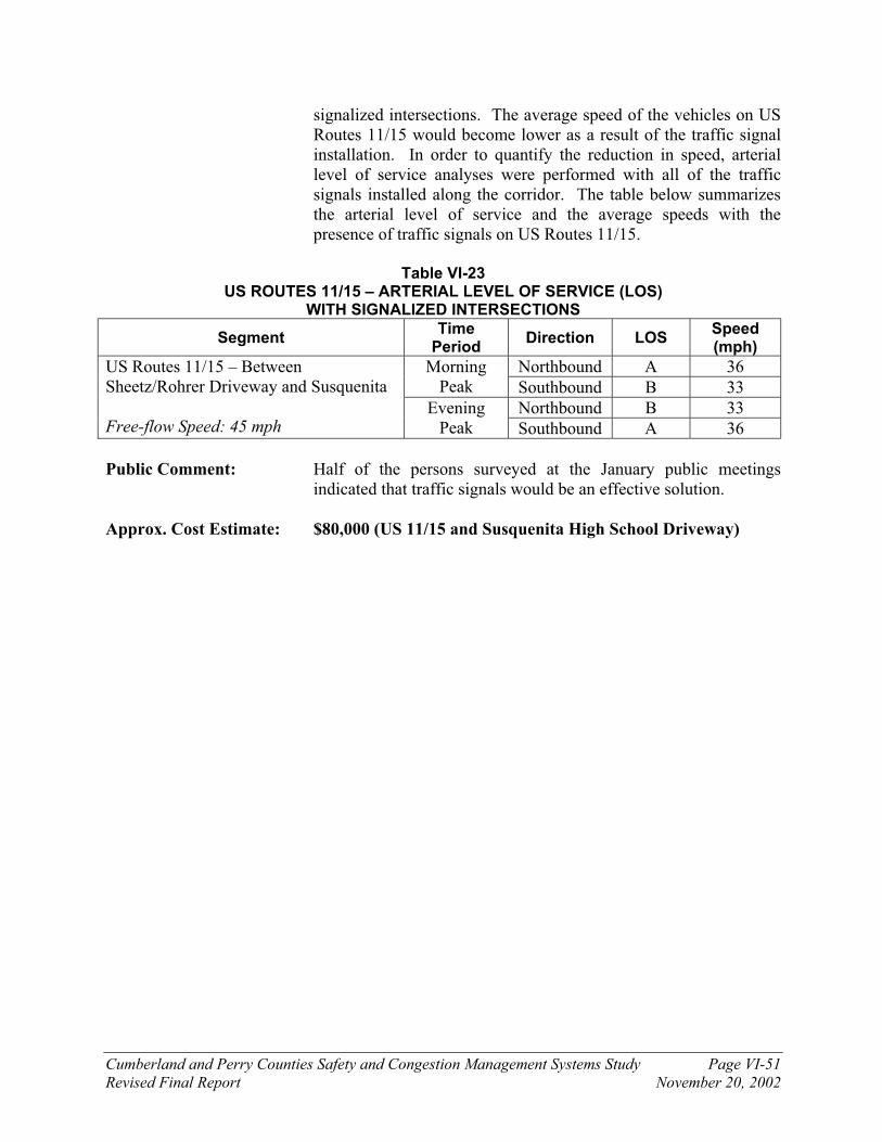
Cumberland and Perry Counties Safety and Congestion Management Systems Study Page VI-51
Revised Final Report November 20, 2002
signalized intersections. The average speed of the vehicles on US Routes 11/15 would become lower as a result of the traffic signal installation. In order to quantify the reduction in speed, arterial level of service analyses were performed with all of the traffic signals installed along the corridor. The table below summarizes the arterial level of service and the average speeds with the presence of traffic signals on US Routes 11/15.
Table VI-23
US ROUTES 11/15 – ARTERIAL LEVEL OF SERVICE (LOS) WITH SIGNALIZED INTERSECTIONS
Segment Time
Period Direction LOS
Speed (mph)
Northbound A 36 Morning Peak Southbound B 33
Northbound B 33
US Routes 11/15 – Between Sheetz/Rohrer Driveway and Susquenita Free-flow Speed: 45 mph
Evening Peak Southbound A 36
Public Comment: Half of the persons surveyed at the January public meetings indicated that traffic signals would be an effective solution.
Approx. Cost Estimate: $80,000 (US 11/15 and Susquenita High School Driveway)

Cumberland and Perry Counties Safety and Congestion Management Systems Study Page VI-52
Revised Final Report November 20, 2002
IMPROVEMENT CONCEPT SUMMARY
Location(s): US Routes 11/15 and Shady Lane intersection Location Number /
Improvement Package: 11-06 / 11-B
Statement of problem: An examination of the crash data and the physical geometry of the intersection demonstrates that this location experiences insufficient intersection sight distance. Because of the sharp vertical curve immediately to the south, the intersection of US Routes 11/15 and Shady Lane appears to experience poor intersection sight distance. The traffic signal at the shopping center driveway immediately north of this location does create gaps in the traffic stream, but sight distance problems still exist.
Proposed Solution(s): Because the above location appears to experience insufficient sight distance, physical alterations could be made at the deficient location so that the sight distance is improved (if the benefits justify the costs). In this case, physical alterations should include the flattening of the crest vertical curve immediately to the south.
A less expensive solution to the sight distance problem would be to
install a traffic signal at this location (if the traffic volumes satisfy signal warrants).
Photo of the view looking south on US Routes 11/15 at the
Shady Lane intersection

Cumberland and Perry Counties Safety and Congestion Management Systems Study Page VI-53
Revised Final Report November 20, 2002
Public Comment: The comment was made that a traffic signal would be unlikely here because of the new signal at the shopping center, which is immediately north of this intersection.
Approx. Cost Estimate: $400,000 (vertical curve adjustments) $80,000 (traffic signal installation)

Cumberland and Perry Counties Safety and Congestion Management Systems Study Page VI-54
Revised Final Report November 20, 2002
IMPROVEMENT CONCEPT SUMMARY Location(s): US Routes 11/15 in Marysville Location Number /
Improvement Package: 11-07 / 11-A
Statement of problem: There are over ten intersections with US Routes 11/15 within the borough of Marysville. The highly concentrated area of intersections has safety concerns because of the many points of conflict between the turning and through traffic.
Proposed Solution(s): Access management strategies
Examine feasibility of converting certain streets in Marysville that intersect US Routes 11/15 to one-way streets. Upon initial examination, Walnut, Chestnut, and Landsvale Streets could be converted to one-way in the eastbound direction, and Blackberry, William, Funts Alley, and Cassel Streets could be converted to one-way in the westbound direction. PA Route 850 (Valley Street) should remain as a two-way east-west street. Front Street is currently one-way in the eastbound direction, and Cameron Street is currently one-way in the westbound direction. Also examine the feasibility of the elimination of direct access to US Routes 11/15 for particular roadways. Additionally, the “Main Street” concept that is proposed for Perdix (see location number 11-10 for details) is suggested to extend into Marysville.
Public Comment: No specific response (either positive or negative) was received from the public on this concept.
Approx. Cost Estimate: $150,000 (One-way street re-designation) $4 million (Access closure)
Photo of the view from southbound US Routes 11/15
in Marysville

Cumberland and Perry Counties Safety and Congestion Management Systems Study Page VI-55
Revised Final Report November 20, 2002
IMPROVEMENT CONCEPT SUMMARY Location(s): US Routes 11/15 in the Perdix Area Location Number /
Improvement Package: 11-10 / 11-A
Statement of problem: The section of US Routes 11/15 in the Perdix area is currently a heavily traveled section of two-lane roadway with extremely narrow or non-existent shoulders, parked cars along the side of the road, and school-age pedestrians. Emergency vehicles have difficulty exiting the Perdix Firehouse because of the heavy traffic on US Routes 11/15.
An examination of the crash data demonstrates that safety problems currently exist and are projected to exist along this section of the US Routes 11/15 corridor.
Table VI-24
US ROUTES 11/15 CRASH RATE COMPARISON
Length (miles) Crash Rate (Crashes/MVM)
Segment Total Over
Statewide Crash Rate
Statewide Average
Observed Percent
Difference
Perdix (Woodland Drive) to Duncannon (PA Route 274)
6.02 5.21 0.29 0.85 194 percent
Photo on southbound US Routes 11/15 in the Perdix Area

Cumberland and Perry Counties Safety and Congestion Management Systems Study Page VI-56
Revised Final Report November 20, 2002
Proposed Solution(s): Develop pedestrian facilities in Perdix. US Routes 11/15 in this section is currently a two-lane road without sidewalks and with parked cars and single-family homes along the roadway. Consider prohibiting parking and constructing sidewalks and crosswalks to provide for safety of pedestrians, especially the school-age children. Also consider placing pedestrian warning signs and street lighting along US Routes 11/15 through the Perdix area. Install emergency flashing signal on US Routes 11/15 at the Perdix Firehouse driveway to allow for safe emergency vehicle egress onto US Routes 11/15.
Sections of US Routes 11/15 in Perdix currently have very narrow shoulders (one to four feet wide). The shoulders should be widened and/or parking should be prohibited to provide an escape area for drivers avoiding a collision. Because the through route to the north from Harrisburg is technically on the other side of the river (on US Routes 22/322), through traffic could be further discouraged from using US Routes 11/15 with the implementation of traffic calming measures in the Perdix area in combination with the installation traffic signals in Marysville and Cove. Traffic calming measures such as bicycle lanes, sidewalks, and crosswalks will give the Perdix area a ‘village’ character. The narrow shoulders in Perdix could possibly be improved and the traffic calming measures could be implemented along with the planned installation of sewer lines in the area. Construct a bypass around Perdix (Alternative C) to remove through traffic from the roadway or install a two-way center left-turn lane through Perdix. Implement access management strategies in Perdix by consolidating driveways and intersections. Many of the above improvements are combined into what is known as a “Main Street” concept. A parking driveway / access roadway would be constructed behind the existing homes along US Routes 11/15 in order to provide adequate parking (after parking is prohibited on US Routes 11/15). Bicycle lanes / walking paths will also be constructed along this stretch of US Routes 11/15 in coordination with the Susquehanna Greenway. The “Main Street” concept is proposed for sections of US Routes 11/15 in Marysville as well. See the concept sketch shown below for a better idea of what is involved with the “Main Street” concept.

Cumberland and Perry Counties Safety and Congestion Management Systems Study Page VI-57
Revised Final Report November 20, 2002
Public Comment: There was mixed response to different aspects of this improvement concept. Please see Chapter IX for a detailed summary of public comments from the October 30, 2002 Perdix / Marysville public meeting.
Approx. Cost Estimate: $690,000 (Pedestrian facilities)
$135,000 (Street lights) $6.2 million (Widen shoulders)
$80,000 (Flashing light for fire house)
$61 million (New bypass around Perdix – Alternative C) $56 million (Two-way center left-turn lane) $1.2 million (Access management)
FIGURE
Conceptual Preliminary Improvement Options - Plan ViewUS Routes 11/15 - Perdix AreaSafety and Congestion Management System StudyCUMBERLAND AND PERRY COUNTIES, PENNSYLVANIA
11 15(SB) to I-81
SUSQUEHANNA RIVER
RESIDENCESRESIDENCESFIREHOUSERESIDENCES
(NB) to Duncannon
RESIDENCESRESIDENCES
Bicycle Lane
PARKING ACCESS ROAD PARKING ACCESS ROAD
PROHIBIT PARKING PROHIBIT PARKING
CONSTRUCTSIDEWALKS
CONSTRUCTSIDEWALKS
STOPSIGN
CONSTRUCT FLASHINGSIGNAL AT THE PERDIXFIREHOUSE
ADD CROSSWALKS NEAR SCHOOL
BUS STOPS
POSSIBLEPARKING
AREA
PARKING ACCESS ROAD
CONSTRUCTRIVER
ACCESS
Bicycle LanePROHIBIT PARKING PROHIBIT PARKING

Cumberland and Perry Counties Safety and Congestion Management Systems Study Page VI-58
Revised Final Report November 20, 2002
IMPROVEMENT CONCEPT SUMMARY Location(s): US Routes 11/15 interchange with Interstate 81 Location Number /
Improvement Package: 11-08 / 11-B
Statement of problem: An examination of the crash data at this interchange indicates that seven out of nine crashes at the Interstate 81 interchange were rear end collisions. The lengths of the deceleration lanes, acceleration lanes, and weaving lanes at the interchanges appear to be deficient.
Proposed Solution(s): Review the weaving speeds and the lengths of the deceleration lanes and acceleration lanes. If the detailed studies reveal that the interchange design is deficient for amount of traffic and the observed speeds of vehicles using the interchange, then the interchange should be redesigned and reconstructed (if the benefits justify the costs).
Public Comment: No specific response (either positive or negative) was received
from the public on this concept.
Approx. Cost Estimate: $20.8 million (Reconstruction of US 11/15 and I-81 interchange)

Cumberland and Perry Counties Safety and Congestion Management Systems Study Page VI-59
Revised Final Report November 20, 2002
IMPROVEMENT CONCEPT SUMMARY Location(s): US Routes 11/15 interchange with US Routes 22/322 Location Number /
Improvement Package: 11-09 / 11-E Statement of problem: An examination of the crash data at this interchange indicates that
thirteen out of nineteen crashes at the US Routes 22/322 interchange involved a collision with a fixed object. The lengths of the deceleration lanes, acceleration lanes, and weaving lanes at the interchanges appear to be deficient.
Proposed Solution(s): Review the weaving speeds and the lengths of the deceleration lanes and acceleration lanes. If the detailed studies reveal that the interchange design is deficient for amount of traffic and the observed speeds of vehicles using the interchange, then the interchange should be redesigned and reconstructed (if the benefits justify the costs).
Another solution would be to force all eastbound traffic on US
Routes 22/322 that wishes to continue on US Routes 22/322 through the US Routes 11/15 interchange area into the left lane. This would eliminate the weave area on eastbound US Routes 22/322 by allowing motorists that are headed from US Routes 11/15 southbound to have their own lane as they enter US Routes 22/322 eastbound. Although the normal peak hour traffic volumes on US Routes 22/322 eastbound approaching the US Routes 11/15 interchange are low enough that travel in a single lane through the interchange can be accommodated, the increased traffic volumes on the event weekends (Penn State Football games, hunting season, etc.) could cause delays if the traffic was forced to use a single lane.
Public Comment: No specific response (either positive or negative) was received from the public on this concept.
Approx. Cost Estimate: $14.2 million (US 11/15 and US 22/322) $88,000 (Lane merge on US 22/322)

Cumberland and Perry Counties Safety and Congestion Management Systems Study Page VI-60
Revised Final Report November 20, 2002
IMPROVEMENT CONCEPT SUMMARY Location(s): US Routes 11/15 – (PA Route 274 to Interstate 81) Location Number /
Improvement Package: 11-01 / 11-A
Statement of problem: An examination of the crash data, the traffic count data, and the capacity analyses demonstrates that safety problems and congestion problems currently exist and are projected to exist along this section of the US Routes 11/15 corridor.
Proposed Solution(s): An inexpensive strategy that can be used to reduce the number of vehicles on US Routes 11/15 would be to encourage carpooling. The installation of “Share-a-Ride” signs near the northbound and southbound entrance points of the two-lane section of US Routes 11/15 (Northbound – near the Cumberland / Perry County border, Southbound – just south of the Duncannon interchange).
ITS equipment, namely variable message signs (VMS) should be installed near
the US Routes 11/15 junctions with I-81 and US Routes 22/322. The approximate travel time on both of the river routes (US 11/15 and US 22/322) would be provided to motorists so they can make a better decision on which route to take.
A park-and-ride lot should be constructed near the interchange of PA Route 274
and US Routes 11/15. As discussed in the Penn Township, Perry County Park N’ Ride Study, written by Tri-County Regional Planning Commission in Spring 1999, the lot should be constructed at either the existing American Legion or the Norfolk Southern property. Both locations are located very close to the interchange. This project is currently on the TIP (4th year).
Another inexpensive strategy that would likely reduce the number of long-
distance trips to this section of US Routes 11/15 could be to Re-sign US Routes 11/15 as ‘Business’ US Routes 11/15. With the completion of the Dauphin Narrows Bypass (US Routes 22/322), a viable alternative limited-access through route between Interstate 81 and the Clarks Ferry area now exists. Existing US Routes 11/15 between the Interstate 81 interchange and the US Routes 22/322 interchange could be re-signed as ‘Business’ US Routes 11/15. The labeling of US Routes 11/15 would then be placed on Interstate 81 across the Susquehanna River and then westbound on the US Routes 22/322 bypass until it meets the existing US Routes 22/322 and US Routes 11/15 interchange. The prohibition of through truck traffic on this section of US Routes 11/15 should also be examined in concert with the Route Relocation Study. The Route Relocation Study will need to include a Business Impact Survey that would determine the financial impacts of a route-designation to the owners of the businesses along US Routes 11/15.
Public Comment: Business owners are generally opposed to renaming existing US Routes 11/15.
Approx. Cost Estimate: $22,000 (Share-A-Ride signs)
$200,000 (ITS equipment)
$240,000 (Park-and-ride lot)
$350,000 (Business 11/15 designation and Route Relocation Study)

Cumberland and Perry Counties Safety and Congestion Management Systems Study Page VI-61
Revised Final Report November 20, 2002
IMPROVEMENT CONCEPT SUMMARY Location(s): US Routes 11/15 – (PA Route 274 to Interstate 81) Location Number /
Improvement Package: 11-01 / 11-H
Statement of problem: An examination of the crash data, the traffic count data, and the capacity analyses demonstrates that safety problems and congestion problems currently exist and are projected to exist along this section of the US Routes 11/15 corridor.
Proposed Solution(s): A long-range improvement solution involves the construction of a new roadway corridor (Alternative B). The new roadway corridor would branch off from US Routes 11/15 near the end of the freeway section south of Duncannon, then it would head south to connect to either the PA Route 944 and PA Route 114 intersection, the Interstate 81 and PA Route 581 interchange, or US Routes 11/15 immediately north of Interstate 81.
Preliminary analysis of the proposed roadway shows diversion up to 600 vehicles during the morning peak hour and up to 900 vehicles during the evening peak hour. Total daily traffic estimates for the proposed roadway are approximately 10,000 vehicles per day. This traffic is diverted from southern sections of US Routes 11/15 and eastern sections of SR 850 (assuming an intersection between SR 850 and the proposed roadway). This reduction provides significant relief to the southern sections of US Routes 11/15. The new roadway corridor draws traffic off of roadways to which they are parallel (US Routes 11/15).
The construction of a new roadway will have minimal traffic
impacts to other roadway corridors in the study area in addition to US Routes 11/15. A new roadway would draw a small amount of traffic off of the other existing parallel corridors, but it would draw traffic to the roadway corridors that have an intersection with the new off-line alternative.
Public Comment: There as been generally favorable public response to this concept.
Approx. Cost Estimate: $310 million (New roadway – Alternative B)

Cumberland and Perry Counties Safety and Congestion Management Systems Study Page VI-62
Revised Final Report November 20, 2002
IMPROVEMENT CONCEPT SUMMARY Location(s): US Routes 11/15 – at Kinkora Heights (between PA 274 and Cove
Road) (11-04) and at the Cumberland / Perry County Border (11-12) Location Number /
Improvement Package: 11-04 / 11-F 11-12 / 11-F
Statement of problem: Rock falls are prevalent at this location along the US Routes 11/15 corridor.
Proposed Solution(s): Walls and/or fences should be installed to provide protection from falling rocks on the mountainous sections of US Routes 11/15 between Interstate 81 and PA Route 274 especially at Kinkora Hieghts (immediately south of PA Route 274) and at the Cumberland/Perry county border. Additional cut to the back slopes might be required to increase/maintain the shoulder widths. PENNDOT is currently planning improvements at the Cumberland / Perry County border.
Public Comment: No specific response (either positive or negative) was received from the public on this concept.
Approx. Cost Estimate: $250,000 (11-04)
$495,000 (11-12)

PA Route 274 - Locations of Proposed ImprovementsSafety and Congestion Management System StudyCUMBERLAND AND PERRY COUNTIES, PENNSYLVANIA
Legend274-01 - Improvement concept location code number
BARN
ETT RD
FACULTY R
D
FIGURE
11 15
22274
34
27434
34
849
147
274-01 34-C
274-03 274-A
Legend 274-01 – Improvement concept location code number 274-A – Improvement package code number
The improvement packages and improvement concepts shown in italic boldface are placed on the Implementation Plan.
VI-4
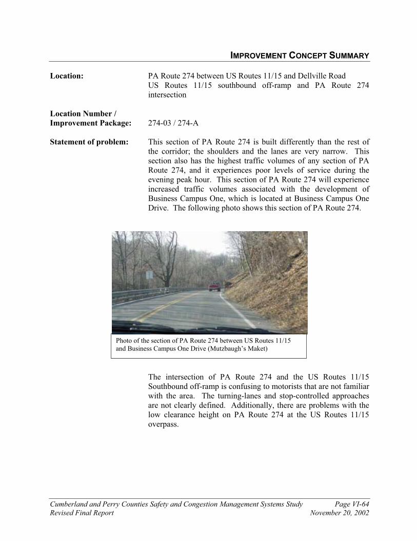
Cumberland and Perry Counties Safety and Congestion Management Systems Study Page VI-64
Revised Final Report November 20, 2002
IMPROVEMENT CONCEPT SUMMARY Location: PA Route 274 between US Routes 11/15 and Dellville Road US Routes 11/15 southbound off-ramp and PA Route 274
intersection
Location Number /
Improvement Package: 274-03 / 274-A Statement of problem: This section of PA Route 274 is built differently than the rest of
the corridor; the shoulders and the lanes are very narrow. This section also has the highest traffic volumes of any section of PA Route 274, and it experiences poor levels of service during the evening peak hour. This section of PA Route 274 will experience increased traffic volumes associated with the development of Business Campus One, which is located at Business Campus One Drive. The following photo shows this section of PA Route 274.
The intersection of PA Route 274 and the US Routes 11/15 Southbound off-ramp is confusing to motorists that are not familiar with the area. The turning-lanes and stop-controlled approaches are not clearly defined. Additionally, there are problems with the low clearance height on PA Route 274 at the US Routes 11/15 overpass.
Photo of the section of PA Route 274 between US Routes 11/15 and Business Campus One Drive (Mutzbaugh’s Maket)

Cumberland and Perry Counties Safety and Congestion Management Systems Study Page VI-65
Revised Final Report November 20, 2002
Proposed Solutions: Widening of the narrow shoulders should aid in the increase of capacity along this section of PA Route 274. The safety along this area of the PA Route 274 corridor would also be enhanced by the widening of the narrow shoulders. Roadside hazards should also be removed or guiderails should be installed to protect traffic. The deficiencies in design in this section need to be addressed .
At the intersection of PA Route 274 and the US Routes 11/15 Southbound ramps, treat roadway with stop bars and rumble strips so that the approaches and movements that are controlled by a stop sign are clearly defined. Clearly define turning lanes on all approaches by re-striping intersection. The eastbound approach of PA Route 274 should be striped as a separate through lane and right-turn lane. Add “3-Way” sign to each stop sign to advise motorists that three approaches to this intersection are controlled by a stop sign. Also, add more signage indicating the low clearance height experienced at the US Routes 11/15 overpass. The overhead clearance at this location should be improved. The current clearance height of the overpass is signed as 13’7”. The clearance height for collector roadways such as PA Route 274 should be 14’6”.
Public Comment: No specific response (either positive or negative) was received from the public on this concept.
Approx. Cost Estimate: $2.2 million (widen shoulders) $320,000 (install guide rail)
$11,000 (Intersection restriping)
$1.1 million (Increase clearance by re-grading roadways)
$3.6 million (Increase clearance by modifications to overpass)
Photo of the view from eastbound PA Route 274 looking at
US Routes 11/15 overpass and southbound off -ramp

Cumberland and Perry Counties Safety and Congestion Management Systems Study Page VI-66
Revised Final Report November 20, 2002
IMPROVEMENT CONCEPT SUMMARY
Location: PA Route 274 and SR 2006 intersection (PA Route 274 – at Mecks Corner)
Location Number /
Improvement Package: 274-01 / 34-C
Statement of problem: An examination of the crash data and the physical geometry of the intersection demonstrates that this location experiences insufficient intersection sight distance. Because of the sharply skewed intersection alignment and the vertical curve on PA Route 274 west of the intersection, the eastbound approach of SR 2006 appears to experience poor sight distance at the PA Route 274 intersection.
Proposed Solution: Because the above location appears to experience insufficient sight distance, physical alterations could be made at the deficient location so that the sight distance is improved (if the benefits justify the costs). In this case, physical alterations should include the flattening of the crest vertical curve west of the intersection and the lessening of the skew angle at the intersection
Another solution would be to relocate PA Route 274 between this intersection and its intersection with PA Route 34.
Public Comment: No specific response (either positive or negative) was received from the public on this concept.
Approx. Cost Estimate: $500,000 (modifications at intersection)
$3.4 million (relocate roadway)
Photo of the view from PA Route 274 westbound approaching its intersection with SR 2006 at Mecks Corner
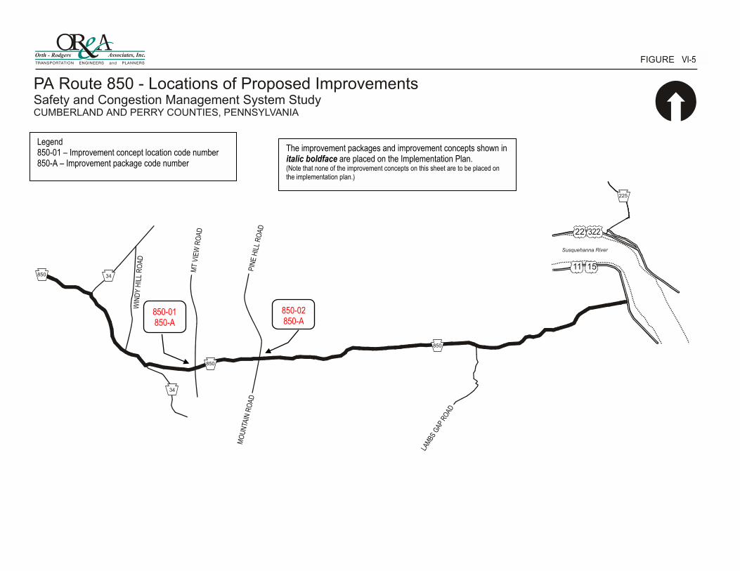
PA Route 850 - Locations of Proposed ImprovementsSafety and Congestion Management System StudyCUMBERLAND AND PERRY COUNTIES, PENNSYLVANIA
Legend850-01 - Improvement concept location code number
Susquehanna River
LAM
BS G
AP R
OAD
MO
UN
TAIN
RO
AD
PIN
E H
ILL
RO
AD
WIN
DY
HIL
L R
OA
D
MT
VIE
W R
OA
D 22
11 15850 34
850
850
225
34
FIGURE
850-01 850-A
850-02 850-A
Legend 850-01 – Improvement concept location code number 850-A – Improvement package code number
The improvement packages and improvement concepts shown in italic boldface are placed on the Implementation Plan. (Note that none of the improvement concepts on this sheet are to be placed on the implementation plan.)
VI-5
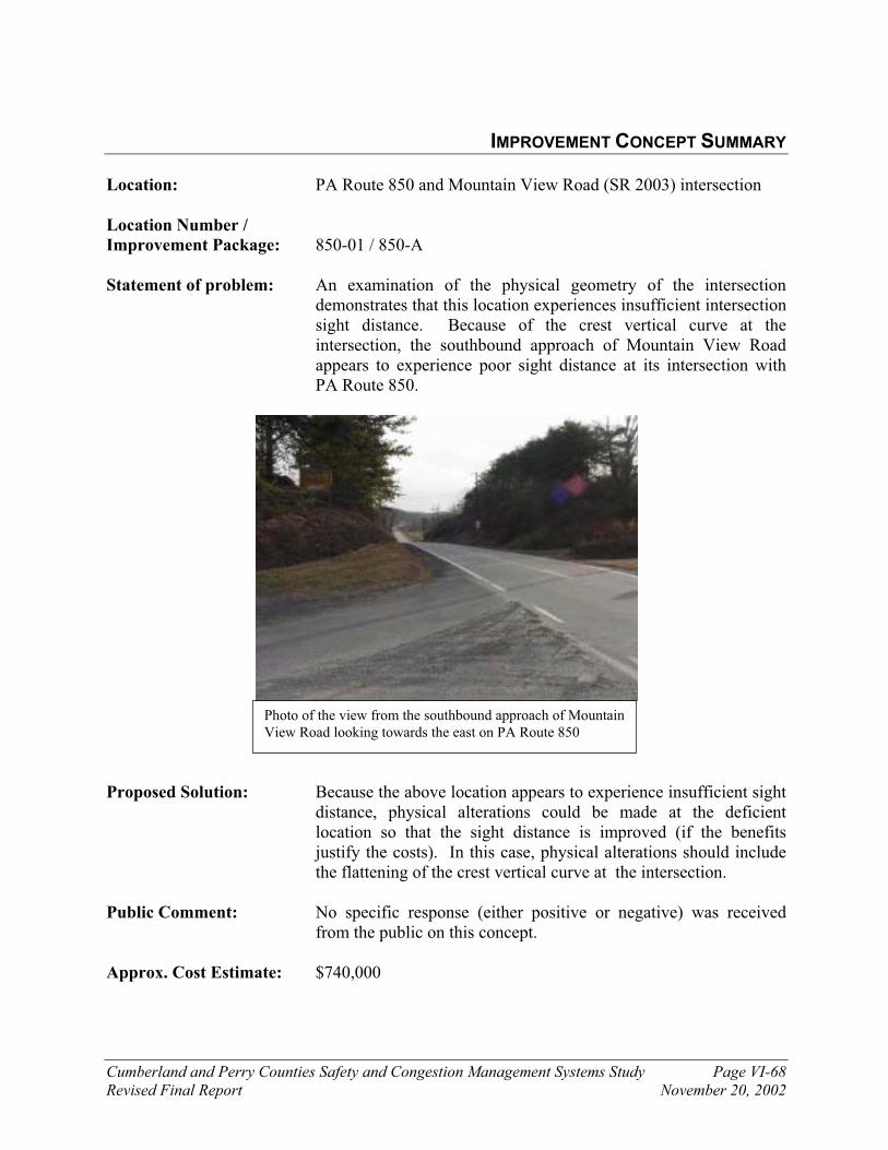
Cumberland and Perry Counties Safety and Congestion Management Systems Study Page VI-68
Revised Final Report November 20, 2002
IMPROVEMENT CONCEPT SUMMARY
Location: PA Route 850 and Mountain View Road (SR 2003) intersection Location Number /
Improvement Package: 850-01 / 850-A
Statement of problem: An examination of the physical geometry of the intersection demonstrates that this location experiences insufficient intersection sight distance. Because of the crest vertical curve at the intersection, the southbound approach of Mountain View Road appears to experience poor sight distance at its intersection with PA Route 850.
Proposed Solution: Because the above location appears to experience insufficient sight distance, physical alterations could be made at the deficient location so that the sight distance is improved (if the benefits justify the costs). In this case, physical alterations should include the flattening of the crest vertical curve at the intersection.
Public Comment: No specific response (either positive or negative) was received from the public on this concept.
Approx. Cost Estimate: $740,000
Photo of the view from the southbound approach of Mountain
View Road looking towards the east on PA Route 850

Cumberland and Perry Counties Safety and Congestion Management Systems Study Page VI-69
Revised Final Report November 20, 2002
IMPROVEMENT CONCEPT SUMMARY Location: PA Route 850 and Pine Hill Road / Mountain Road intersection Location Number /
Improvement Package: 850-02 / 850-A
Statement of problem: An examination of the physical geometry of the intersection demonstrates that this location experiences insufficient intersection sight distance. The approaches of Pine Hill Road and Mountain Road experience poor sight distance because of the sharp vertical curve located immediately east of the intersection.
Proposed Solution: Because the above location appears to experience insufficient sight distance, physical alterations could be made at the deficient location so that the sight distance is improved (if the benefits justify the costs). In this case, physical alterations should include the flattening of the crest vertical curve that is located immediately east of the intersection on PA Route 850.
Public Comment: No specific response (either positive or negative) was received
from the public on this concept.
Approx. Cost Estimate: $380,000
Photo of the view from the southbound approach of Pine Hill Road looking towards the east on PA Route 850

PA Route 849 - Locations of Proposed ImprovementsSafety and Congestion Management System StudyCUMBERLAND AND PERRY COUNTIES, PENNSYLVANIA
Legend849-01 - Improvement concept location code number
325
147
274
34
34
849
22
22
11 15
322
22 322
11 15
FIGURE
849-02 849-B
849-01 849-A
849-04 849-C
849-03 N/A
Legend 849-01 – Improvement concept location code number 849-A – Improvement package code number
The improvement packages and improvement concepts shown in italic boldface are placed on the Implementation Plan.
VI-6

Cumberland and Perry Counties Safety and Congestion Management Systems Study Page VI-71
Revised Final Report November 20, 2002
IMPROVEMENT CONCEPT SUMMARY Location: PA Route 849 and US Routes 22/322 intersection
Location Number /
Improvement Package: 849-02 / 849-B
Statement of problems: Motorists that use the eastbound approach of PA Route 849 at this intersection experience significant delays and poor levels of service during the morning peak hour as shown in the table below.
Table VI-25
OVERALL INTERSECTION LEVELS OF SERVICE PA ROUTE 849 AND US ROUTES 22/322 INTERSECTION
Existing (2001) Future (2020) Intersection
Morning Evening Morning Evening
PA Route 849 and US Routes 22/322 f c f d a: Unsignalized intersection Level of Service Items in bold text represent undesirable levels of service
Additionally, vehicles have been observed making the illegal left-turn from PA Route 849 eastbound to US Routes 22/322 westbound. Vehicles that desire to access US Routes 22/322 westbound from PA Route 849 must currently follow the signs and cross the Clarks Ferry Bridge and exit at PA Route 147. Then, the motorists can access US Routes 22/322 via the on-ramp from PA Route 147.
Photo of the view from eastbound PA Route 849 at its intersection
with US Routes 22/322
Cumberland and Perry Counties Safety and Congestion Management Systems Study Page VI-72
Revised Final Report November 20, 2002
Proposed Solutions: Mitigate morning peak hour delay experienced at this location by
constructing an acceleration lane onto eastbound US Routes 22/322. With new development occurring along PA Route 849 in Miller and Wheatfield Townships, traffic delays will likely increase. The delay is experienced only during the morning peak hour, and the benefits gained by constructing the acceleration lane may not be justified by the cost and the impacts to the adjacent Clarks Ferry Bridge.
Modify concrete island and add a jersey barrier to the median to further discourage illegal left-turns from PA Route 849 eastbound to US Routes 22/322 westbound.
Widen narrow left-turn lane on westbound US Routes 22/322.
Public Comment: Concept to further prohibit left-turn vehicles from SR 849 onto westbound US Routes 22/322 was suggested by public. No other specific comments or responses (either positive or negative) were received from the public on these concepts.
Approx. Cost Estimate: $2.1 million (Acceleration lane) $35,000 (Concrete island modification and jersey barrier)
$575,000 (Westbound left-turn lane)

Cumberland and Perry Counties Safety and Congestion Management Systems Study Page VI-73
Revised Final Report November 20, 2002
IMPROVEMENT CONCEPT SUMMARY
Location: Juniata River Bridge on PA Route 849 Location Number /
Improvement Package: 849-01 / 849-A
Statement of problem: The superstructure of the narrow bridge is in deteriorating condition, but the substructure of the bridge seems to be in adequate condition.
Proposed Solution: Because the superstructure of the narrow Juniata River Bridge is in deteriorating condition, it may soon need to be repaired or replaced. It is also imperative to maintain pedestrian access to this bridge because it is a part of the Appalachian Trail.
If this bridge is replaced, consideration should be given to the
possibility of designing the new structure such that it would be built over the Duncannon Subway.
Public Comment: No specific response (either positive or negative) was received
from the public on this concept.
Approx. Cost Estimate: $5.6 million (bridge replacement) $3.75 million (superstructure rehabilitation)
Photo of the view from eastbound PA Route 849 approaching the Juniata River Bridge

Cumberland and Perry Counties Safety and Congestion Management Systems Study Page VI-74
Revised Final Report November 20, 2002
IMPROVEMENT CONCEPT SUMMARY Location: The Duncannon Subway on PA Route 849 Location Number /
Improvement Package: 849-03 / N/A It should be noted that improvements to the Duncannon Subway are currently being investigated by PENNDOT and are not included in any improvement package. Statement of problem: The Duncannon Subway, which is a vital link between the Borough of
Duncannon and US Routes 22/322, is frequently closed due to flooding during periods of high water levels on the adjacent rivers.
Proposed Solution: Maintain the subway and pump out floodwater to keep the road open by installing flap gates and a water pumping station. It is imperative that the section of PA Route 849 through the Duncannon Subway remains open because this section of roadway is very important for emergency vehicle access to and from the Borough of Duncannon. It should be noted that PENNDOT has recently completed some general drainage improvements at this location.
A long-term solution would be to construct a new bridge over the
railroad tracks at this location.
Public Comment: No specific response (either positive or negative) was received from the public on this concept.
Approx. Cost Estimate: $80,000 (Pumping) $19.5 million (New bridge)
Photo of the view from westbound PA Route 849 approaching the
Duncannon Subway

Cumberland and Perry Counties Safety and Congestion Management Systems Study Page VI-75
Revised Final Report November 20, 2002
IMPROVEMENT CONCEPT SUMMARY
Location: PA Route 849 at US Routes 11/15 Location Number /
Improvement Package: 849-04 / 849-C
Statement of problem: Currently, it is difficult to access US Routes 11/15 directly from PA Route 849.
Proposed Solution: Examine potential for interchange between PA Route 849 and US Routes 11/15. Benefit gained by this interchange may not justify the cost or the impacts to prime farmlands located adjacent to the proposed interchange.
Public Comment: No specific response (either positive or negative) was received from the public on this concept.
Approx. Cost Estimate: $32.3 million
Cumberland and Perry Counties Safety and Congestion Management Systems Study Page VII-1
Revised Final Report November 20, 2002
CHAPTER VII
SUMMARY OF OPTIMISTIC SCENARIO AND LAND USE RECOMMENDATIONS
This chapter discusses preparation of a “2020 optimistic scenario” for the Cumberland-Perry
study area, and land use and transportation planning measures that can be used to manage traffic
growth in the Cumberland-Perry study area.
Transportation improvements have been placed on the implementation plan (see Chapter VIII) to
address safety and capacity deficiencies on study area roadways. To test the sensitivity of these
improvements in the event that future development exceeds the level projected in the current
traffic model, a “2020 optimistic scenario” was prepared. It was determined that traffic levels of
service would still be acceptable under optimistic growth conditions.
In addition to this sensitivity test, land use and transportation planning measures have been
proposed to better manage growth in the Cumberland-Perry study area in the future. These
measures are an important supplement to the proposed transportation improvements. Given the
recent completion of US Routes 22/322, and the potential for growth in the study area,
implementation of these measures provides yet another measure of assurance that traffic levels of
service will be acceptable well into the future.
A. ‘Optimistic Scenario’
To determine the ability of planned and proposed roadway improvements to accommodate
potential traffic growth in the Cumberland-Perry study area, a “2020 optimistic scenario” was
analyzed. This scenario – while not a build-out analysis – assumes a more intense level of
development for the year 2020 than in the current model. (Note that the year 2020 demographic
projections for the current model is located in Chapter II of this document.)
It should be emphasized that this “optimistic scenario” was prepared solely for the purpose
of conducting a regional transportation analysis, and gauging the sensitivity of proposed
transportation improvements to land development. Local land use decisions have regional
Cumberland and Perry Counties Safety and Congestion Management Systems Study Page VII-2
Revised Final Report November 20, 2002
transportation impacts, and this illustrates the importance of intermunicipal coordination
in establishing a planning agenda. However, it should also be emphasized that the impacts
upon transportation systems are only one of many factors that should be considered by
municipal officials as they engage in land use planning, and create or modify zoning
districts.
Although the method of projecting future development differed for population and employment,
there were some common principles. Rather than arbitrarily assuming a certain percentage
growth of housing units and employment in the study area, the model derived 2020 projections
based upon “high growth” periods in the past. An analysis was done of developable lands in the
study area to determine if the projected growth in employment or housing units could be
accommodated within the different municipalities. The growth was assigned with preference for
locations in public sewer areas, or close to major roadways, as this infrastructure is normally
present in areas that experience rapid growth. Comprehensive plans and zoning ordinances,
where available, were also used to guide growth. There was also an effort made to avoid over-
assigning growth to Traffic Analysis Zones (TAZ’s) in the study area that already received a
significant housing unit or employment allocation under the current model.
The optimistic employment and population growth for each TAZ was then translated into peak
hour traffic volumes. The improvement packages that have been placed on the implementation
plan were then checked to determine if sufficient capacity was still available with the higher,
optimistic year 2020 traffic volumes. It was determined that the recommended improvements
that have been placed on the implementation plan will be able to accommodate the additional
traffic volumes associated with the surplus optimistic residential and employment development.
Employment
The “2020 optimistic scenario” projects the growth of close to 30,000 jobs in the study area
municipalities from 1995 to 2020. Employment is projected to grow in Cumberland County by
51 percent in this period, and Perry County by 61 percent. The projection of 30,000 jobs
represents an increase of 4,360 jobs over the projection prepared for the traffic model for the
design year of 2020. Table VII-1 indicates projected employment under the optimistic scenario.

Cumberland and Perry Counties Safety and Congestion Management Systems Study Page VII-3
Revised Final Report November 20, 2002
Table VII-I Projected Employment - Year 2020
1995 Current Model
2000 Actual
Employment
2020 Optimistic
Model
1995 - 2020 Change Optimistic Model
Cumberland County Number Percent
East Pennsboro 15,347 0 23,765 8,418 54.9%
Hampden 23,282 0 30,442 7,160 30.8%
Middlesex 5,565 0 10,462 4,897 88.0%
Silver Spring 7,789 0 13,766 5,977 76.7%
TOTAL 51,983 0 78,435 26,452 50.9%
Perry County Number Percent
Bloomfield 666 N/A 862 196 29.4%
Carroll 248 N/A 504 256 103.2%
Centre 59 N/A 131 72 122.0%
Duncannon 1,328 N/A 1,699 371 27.9%
Howe 24 N/A 556 532 2216.7%
Marysville 589 0 903 314 53.3%
Miller 23 N/A 64 41 178.3%
Newport 825 925 1,093 268 32.5%
Oliver 192 N/A 323 131 68.2%
Penn 1,182 N/A 2,007 825 69.8%
Rye 26 N/A 140 114 438.5%
Watts 18 N/A 57 39 216.7%
Wheatfield 39 N/A 78 39 100.0%
TOTAL 5,219 N/A 8,417 3,198 61.3%
Source: Orth-Rodgers & Associates - 2020 Optimistic Model Projections, August 2002
Tri-County Regional Planning Commission - 2020 Current Model Projections
PA Dept of Community and Economic Development - 2000 Municipal Revenue Information
PA Dept of Community and Economic Development - 2020 Occupational Privilege Tax Rates
U.S. Census Bureau - 2000 Census of Population and Housing

Cumberland and Perry Counties Safety and Congestion Management Systems Study Page VII-4
Revised Final Report November 20, 2002
The optimistic forecast for the Perry County municipalities was calculated based upon the
employment growth in the entire county for the period 1990 to 1995, as provided by the
Pennsylvania Department of Labor. The linear growth rate for this period was extrapolated
through the year 2020, and proved to be 19 percent higher than the employment forecast
projected in the current model. Therefore, the employment projection was increased by 1,370.
Howe Township, at the intersection of US 22/322 and PA 34, and with public sewer, was seen as
being one of the areas poised for growth by the year 2020, which was not anticipated in the
current model projections. Much of the growth in this area would likely be in retail. Penn
Township was assigned an additional 130 jobs; these are likely to be office and industrial. The
added jobs for other Perry County municipalities ranged from 25 to 120. All of the Perry County
jobs added under the optimistic scenario fall within the study area.
The optimistic forecast for Cumberland County was also based upon employment growth in the
entire county for the period 1990 to 1995. The linear growth rate for this period was
extrapolated, and was found to be 2 percent higher than the current model. While seemingly
insignificant, this growth rate resulted in 1,500 additional jobs over the current model. The
current model was in some respects optimistic itself, with a higher growth rate than for either the
1990 to 1995, or 1990 to 2000 periods. Indeed, the optimistic model based on 1990 to 1995
growth was 5,500 jobs higher than if the current model had been based on 1990 to 2000 growth.
In an effort to further consider employment potential in Cumberland County, and to build in an
additional “level of optimism,” 1,500 additional jobs were assigned to Cumberland County, for
an increase of 3,000 jobs over the current model. These 1,500 additional jobs were assumed to
be located in the Cumberland Technology Park at the interchange of I-81 and Wertzville Road in
Hampden, and reflects the new employment generated by the IBM facility under construction, as
well as potential for development on other tracts within the Technology Park. In total, close to
2,500 new jobs are projected for the Technology Park and other lands adjacent to the I-81
interchange between 1995 and 2020.
With the exception of the office district at the interchange of I-81 and Wertzville Road, much of
the available land in commercial districts in Cumberland County lies to the south of the study

Cumberland and Perry Counties Safety and Congestion Management Systems Study Page VII-5
Revised Final Report November 20, 2002
area, minimizing the potential impact on study area roads from future commercial development
in those municipalities. A very modest increase was projected in Silver Spring along Wertzville
Road where small commercial zones are located. Of the 3,000 additional jobs projected for
Cumberland County municipalities, 1,755 jobs are within the study area.
Population
The “2020 optimistic scenario” projects the growth of over 14,000 housing units in the study
area from 2000 to 2020, or a 40 percent increase. Cumberland County municipalities are
projected to add 9,670 housing units, and Perry County municipalities 4,370 units. The
optimistic scenario represents an additional 4,410 housing units over the projections prepared for
the traffic model for design year 2020. Population projections are indicated in Table VII-2, and
housing unit projections in Table VII-3.
To determine an optimistic scenario for municipalities in both Cumberland and Perry Counties, a
population projection model was run incorporating historic population trends from 1980 to 2000.
For many of the communities, the results of the geometric model were used for the optimistic
scenario. Because the geometric model assumes continuation of the historic population growth
rate – and not simply continuation of the absolute population growth – the geometric model
typically results in higher population projections than a linear regression model. In two cases –
Hampden Township in Cumberland County, and Howe Township in Perry County – the results
of the parabolic model were adopted, which represent an even higher level of growth.
The models were ideal for projecting optimistic scenarios in Cumberland County, where the
municipalities have experienced fairly constant growth over the past several decades.
Middlesex and Silver Spring Townships are projected to grow at a faster rate than East
Pennsboro or Hampden Township, since they are farther from the Harrisburg Metropolitan Area,
and therefore have not built out to the extent that East Pennsboro and Hampden Townships have.
Of the 3,260 additional housing units in Cumberland County, a total of 880 fall within study area
boundaries.
Cumberland and Perry Counties Safety and Congestion Management Systems Study Page VII-6
Revised Final Report November 20, 2002
Table VII-2 Projected Population - Year 2020
2000 Population2020 Optimistic
Model Population
2000-2020 Change Optimistic Model
Cumberland County
Number Percent
East Pennsboro 18,254 23,293 5,039 27.6%
Hampden 24,135 34,934 10,799 44.7%
Middlesex 6,669 10,046 3,377 50.6%
Silver Spring 10,592 15,493 4,901 46.3%
TOTAL 59,650 83,766 24,116 40.4%
Perry County
Bloomfield 1,077 1,136 59 5.5%
Carroll 5,095 8,055 2,960 58.1%
Centre 2,209 2,963 754 34.1%
Duncannon 1,508 1,573 65 4.3%
Howe 493 666 173 35.1%
Marysville 2,306 3,005 699 30.3%
Miller 953 1,612 659 69.2%
Newport 1,506 1,676 170 11.3%
Oliver 2,061 2,908 847 41.1%
Penn 3,013 4,756 1,743 57.8%
Rye 2,327 3,397 1,070 46.0%
Watts 1,196 1,607 411 34.4%
Wheatfield 3,329 4,817 1,488 44.7%
TOTAL 27,073 38,171 11,098 41.0% Source: Orth-Rodgers & Associates - 2020 Optimistic Model Projections, August 2002
Tri-County Regional Planning Commission, 2020 Current Model Projections
U.S. Census Bureau - 2000 Census of Population and Housing
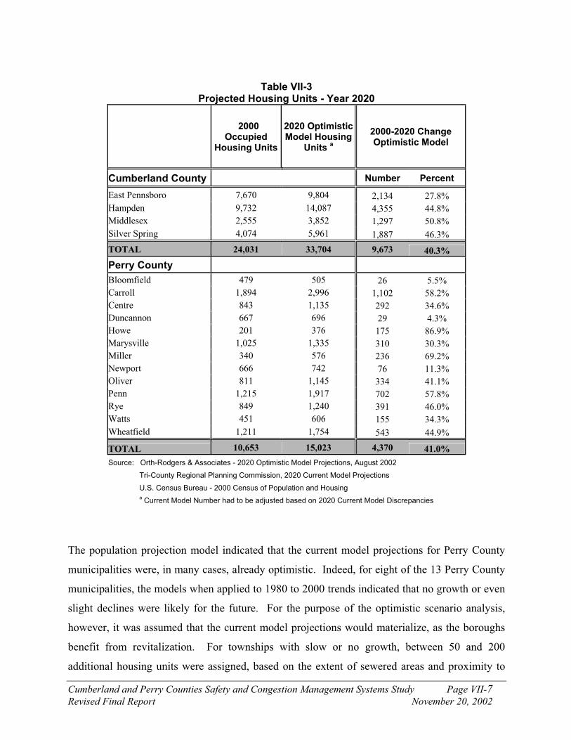
Cumberland and Perry Counties Safety and Congestion Management Systems Study Page VII-7
Revised Final Report November 20, 2002
Table VII-3
Projected Housing Units - Year 2020
2000
Occupied Housing Units
2020 Optimistic Model Housing
Units a
2000-2020 Change Optimistic Model
Cumberland County Number Percent
East Pennsboro 7,670 9,804 2,134 27.8%
Hampden 9,732 14,087 4,355 44.8%
Middlesex 2,555 3,852 1,297 50.8%
Silver Spring 4,074 5,961 1,887 46.3%
TOTAL 24,031 33,704 9,673 40.3%
Perry County
Bloomfield 479 505 26 5.5%
Carroll 1,894 2,996 1,102 58.2%
Centre 843 1,135 292 34.6%
Duncannon 667 696 29 4.3%
Howe 201 376 175 86.9%
Marysville 1,025 1,335 310 30.3%
Miller 340 576 236 69.2%
Newport 666 742 76 11.3%
Oliver 811 1,145 334 41.1%
Penn 1,215 1,917 702 57.8%
Rye 849 1,240 391 46.0%
Watts 451 606 155 34.3%
Wheatfield 1,211 1,754 543 44.9%
TOTAL 10,653 15,023 4,370 41.0%
Source: Orth-Rodgers & Associates - 2020 Optimistic Model Projections, August 2002
Tri-County Regional Planning Commission, 2020 Current Model Projections
U.S. Census Bureau - 2000 Census of Population and Housing a
Current Model Number had to be adjusted based on 2020 Current Model Discrepancies
The population projection model indicated that the current model projections for Perry County
municipalities were, in many cases, already optimistic. Indeed, for eight of the 13 Perry County
municipalities, the models when applied to 1980 to 2000 trends indicated that no growth or even
slight declines were likely for the future. For the purpose of the optimistic scenario analysis,
however, it was assumed that the current model projections would materialize, as the boroughs
benefit from revitalization. For townships with slow or no growth, between 50 and 200
additional housing units were assigned, based on the extent of sewered areas and proximity to

Cumberland and Perry Counties Safety and Congestion Management Systems Study Page VII-8
Revised Final Report November 20, 2002
major roads. In total, the Perry County municipalities were assigned an additional 1,150 housing
units over the current model. All of these units are within study area boundaries.
Impacts to Transportation System
The additional amount of residential and employment growth that would likely occur under an
‘optimistic development’ scenario for the year 2020 is summarized above. The additional
development that was determined is above and beyond what is already included in the TCRPC
traffic model. Residential and employment growth was determined for each municipality within
the study area. A trip generation analysis was performed for the projected development in each
traffic analysis zone (TAZ). Trips were generated for the following land uses:
¶ Single-family homes
¶ Multi-family homes
¶ Retail (shopping center)
¶ Industrial parks
¶ General office space
For the portion of each municipality that lies within the study area, the total daily trip ends
generated by the traffic model in the base year of 2000 are compared to the total daily trip ends
generated in year 2020 under the optimistic development scenario in Table VII-4. Daily and
peak hour trip generation rates for the land uses listed above and some additional land uses are
summarized in Table VII-5.
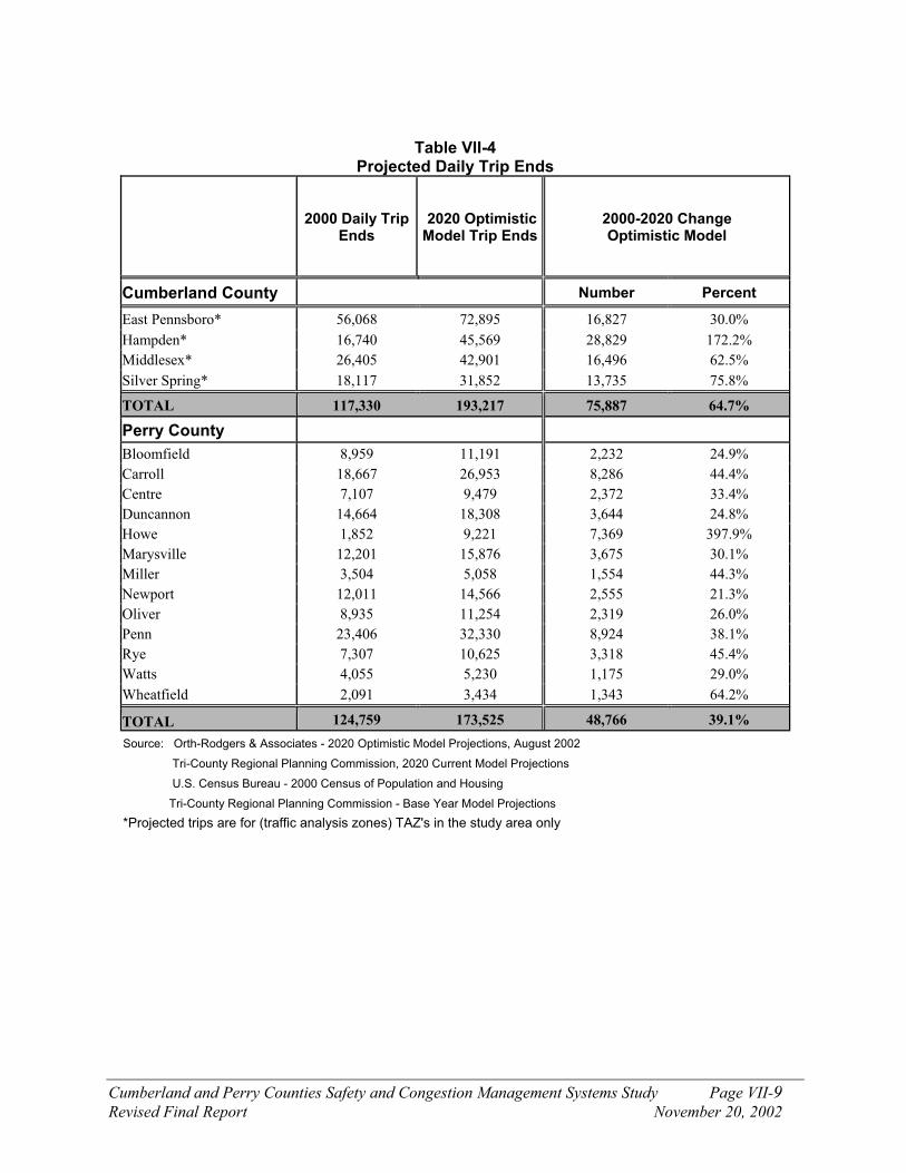
Cumberland and Perry Counties Safety and Congestion Management Systems Study Page VII-9
Revised Final Report November 20, 2002
Table VII-4 Projected Daily Trip Ends
2000 Daily Trip
Ends 2020 Optimistic Model Trip Ends
2000-2020 Change Optimistic Model
Cumberland County Number Percent
East Pennsboro* 56,068 72,895 16,827 30.0%
Hampden* 16,740 45,569 28,829 172.2%
Middlesex* 26,405 42,901 16,496 62.5%
Silver Spring* 18,117 31,852 13,735 75.8%
TOTAL 117,330 193,217 75,887 64.7%
Perry County
Bloomfield 8,959 11,191 2,232 24.9%
Carroll 18,667 26,953 8,286 44.4%
Centre 7,107 9,479 2,372 33.4%
Duncannon 14,664 18,308 3,644 24.8%
Howe 1,852 9,221 7,369 397.9%
Marysville 12,201 15,876 3,675 30.1%
Miller 3,504 5,058 1,554 44.3%
Newport 12,011 14,566 2,555 21.3%
Oliver 8,935 11,254 2,319 26.0%
Penn 23,406 32,330 8,924 38.1%
Rye 7,307 10,625 3,318 45.4%
Watts 4,055 5,230 1,175 29.0%
Wheatfield 2,091 3,434 1,343 64.2%
TOTAL 124,759 173,525 48,766 39.1%
Source: Orth-Rodgers & Associates - 2020 Optimistic Model Projections, August 2002
Tri-County Regional Planning Commission, 2020 Current Model Projections
U.S. Census Bureau - 2000 Census of Population and Housing
Tri-County Regional Planning Commission - Base Year Model Projections
*Projected trips are for (traffic analysis zones) TAZ's in the study area only
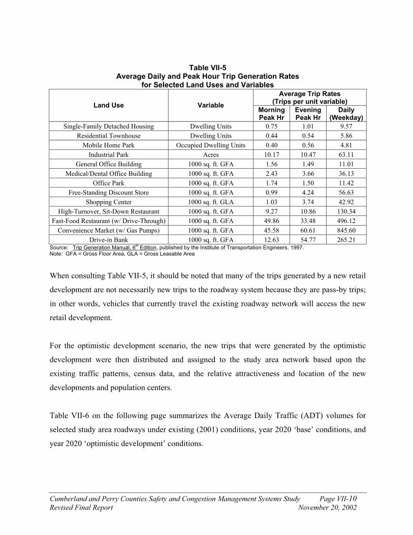
Cumberland and Perry Counties Safety and Congestion Management Systems Study Page VII-10
Revised Final Report November 20, 2002
Table VII-5 Average Daily and Peak Hour Trip Generation Rates
for Selected Land Uses and Variables
Average Trip Rates (Trips per unit variable)
Land Use Variable Morning Peak Hr
Evening Peak Hr
Daily (Weekday)
Single-Family Detached Housing Dwelling Units 0.75 1.01 9.57
Residential Townhouse Dwelling Units 0.44 0.54 5.86
Mobile Home Park Occupied Dwelling Units 0.40 0.56 4.81
Industrial Park Acres 10.17 10.47 63.11
General Office Building 1000 sq. ft. GFA 1.56 1.49 11.01
Medical/Dental Office Building 1000 sq. ft. GFA 2.43 3.66 36.13
Office Park 1000 sq. ft. GFA 1.74 1.50 11.42
Free-Standing Discount Store 1000 sq. ft. GFA 0.99 4.24 56.63
Shopping Center 1000 sq. ft. GLA 1.03 3.74 42.92
High-Turnover, Sit-Down Restaurant 1000 sq. ft. GFA 9.27 10.86 130.34
Fast-Food Restaurant (w/ Drive-Through) 1000 sq. ft. GFA 49.86 33.48 496.12
Convenience Market (w/ Gas Pumps) 1000 sq. ft. GFA 45.58 60.61 845.60
Drive-in Bank 1000 sq. ft. GFA 12.63 54.77 265.21 Source: Trip Generation Manual, 6
th Edition, published by the Institute of Transportation Engineers, 1997.
Note: GFA = Gross Floor Area, GLA = Gross Leasable Area
When consulting Table VII-5, it should be noted that many of the trips generated by a new retail
development are not necessarily new trips to the roadway system because they are pass-by trips;
in other words, vehicles that currently travel the existing roadway network will access the new
retail development.
For the optimistic development scenario, the new trips that were generated by the optimistic
development were then distributed and assigned to the study area network based upon the
existing traffic patterns, census data, and the relative attractiveness and location of the new
developments and population centers.
Table VII-6 on the following page summarizes the Average Daily Traffic (ADT) volumes for
selected study area roadways under existing (2001) conditions, year 2020 ‘base’ conditions, and
year 2020 ‘optimistic development’ conditions.

Cumberland and Perry Counties Safety and Congestion Management Systems Study Page VII-11
Revised Final Report November 20, 2002
Table VII-6
Average Daily Traffic (ADT) Comparison
2001 ADT 2020 ADT
Location Existing Base
Optimistic Scenario
% Difference: Existing
(2001) to Opt. Scenario
(2020)
PA 34 - Between PA 274 and PA 850 7,250 9,400 9,900 37%
PA 34 - Between PA 850 and PA 850 13,800 17,900 19,200 39%
PA 34 - Between PA 850 and Sunnyside Dr 17,550 23,500 25,700 46%
PA 944 - Between Sunnyside Dr and PA 114 13,600 21,900 23,900 76%
PA 944 - Between East of PA 114 6,100 11,800 12,100 98%
US 11/15 - Between PA 274 and PA 850 16,350 22,300 24,200 48%
US 11/15 - Between PA 850 and I-81 22,000 29,500 32,700 49%
US 11/15 – South of PA 944 21,750 37,000 37,400 72%
PA 274 – West of US 11/15 9,350 13,000 13,500 44%
PA 850 – West of US 11/15 5,400 7,400 9,300 72%
PA 849 - W of US 22/322 4,850 8,000 8,300 71%
US 22/322 - Between US 11/15 and PA 849 35,600 38,100 42,500 19%
US 22/322 - Between PA 849 and PA 147 40,000 44,300 49,000 23%
Sunnyside Dr (SR 1007) 11,000 14,200 16,300 48%
The extra development associated with the optimistic growth scenario is responsible for roughly
5 to 15 percent additional traffic on the study area roadways.
Capacity analyses were performed at key bottleneck intersections. The intersections were
analyzed using traffic volumes during the critical peak hour. In the study area, the critical peak
hour is the evening peak hour. Additionally, the new developments will generate the maximum
amount of new trips during the evening peak hour. The capacity analysis was performed using
the roadway improvements that have been placed in the implementation plan. The overall
intersection Levels of Service (LOS) for the year 2020 ‘base’ traffic volumes and the year 2020
‘optimistic development scenario’ traffic volumes are summarized on the following page in
Table VII-7.
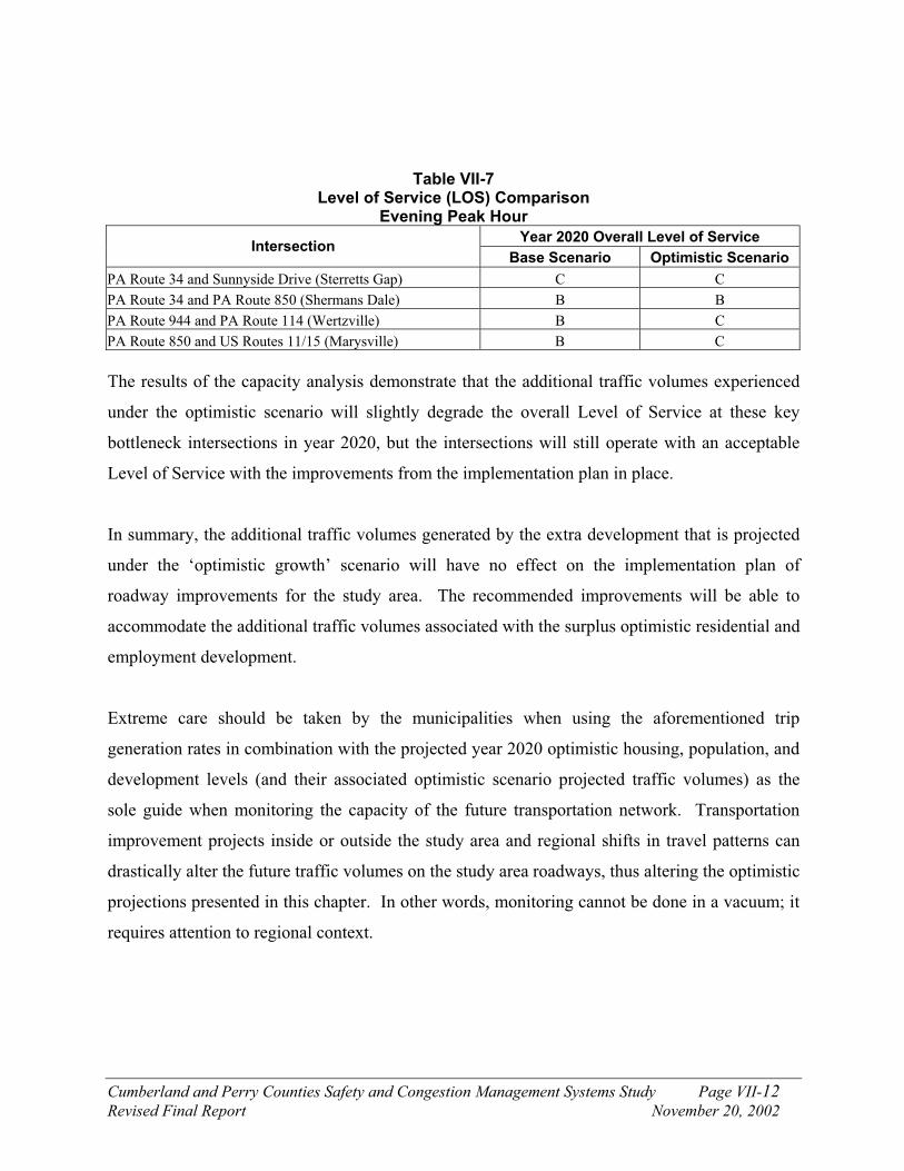
Cumberland and Perry Counties Safety and Congestion Management Systems Study Page VII-12
Revised Final Report November 20, 2002
Table VII-7 Level of Service (LOS) Comparison
Evening Peak Hour
Year 2020 Overall Level of Service Intersection
Base Scenario Optimistic Scenario
PA Route 34 and Sunnyside Drive (Sterretts Gap) C C
PA Route 34 and PA Route 850 (Shermans Dale) B B
PA Route 944 and PA Route 114 (Wertzville) B C
PA Route 850 and US Routes 11/15 (Marysville) B C
The results of the capacity analysis demonstrate that the additional traffic volumes experienced
under the optimistic scenario will slightly degrade the overall Level of Service at these key
bottleneck intersections in year 2020, but the intersections will still operate with an acceptable
Level of Service with the improvements from the implementation plan in place.
In summary, the additional traffic volumes generated by the extra development that is projected
under the ‘optimistic growth’ scenario will have no effect on the implementation plan of
roadway improvements for the study area. The recommended improvements will be able to
accommodate the additional traffic volumes associated with the surplus optimistic residential and
employment development.
Extreme care should be taken by the municipalities when using the aforementioned trip
generation rates in combination with the projected year 2020 optimistic housing, population, and
development levels (and their associated optimistic scenario projected traffic volumes) as the
sole guide when monitoring the capacity of the future transportation network. Transportation
improvement projects inside or outside the study area and regional shifts in travel patterns can
drastically alter the future traffic volumes on the study area roadways, thus altering the optimistic
projections presented in this chapter. In other words, monitoring cannot be done in a vacuum; it
requires attention to regional context.

Cumberland and Perry Counties Safety and Congestion Management Systems Study Page VII-13
Revised Final Report November 20, 2002
B. Summary of Growth Management Measures
Cumberland and Perry Counties exhibit distinctly different land use characteristics within the
study area. Cumberland County municipalities – particularly East Pennsboro and Hampden
Townships, which have absorbed much of the suburban development moving outwards from
Harrisburg and along the I-81 / US Route 11 corridor – have experienced significant population
growth in the last two decades. The municipalities in Perry County are much more rural; they
added 4,700 new persons since 1980, as opposed to the growth of 16,300 persons in the
Cumberland County portion of the study area. Further, the vast majority of retail and office
development in the study area within the last two decades has been concentrated within
Cumberland County.
The differences between counties extend to land use controls as well. Cumberland County
municipalities use the full range of land use controls – comprehensive plans, zoning ordinances,
and subdivision and land development ordinances. As of 2002, four of the 13 Perry County
municipalities did not have zoning ordinances, and zoning was only recently enacted in several
others. The difference in use of land use controls in the two counties is not surprising, inasmuch
as many municipalities only become skilled in the use of these controls when confronted by
periodic development.
Although this chapter refers to growth management practices in individual study area
municipalities, it also, on occasion, refers to the Cumberland County municipalities and the Perry
County municipalities as two separate groups, given the differences between these two “sub-
areas” within the overall study area, and to emphasize the broad application of many of these
strategies.
The congestion which exists on study area roadways today will not be affected by any of the
measures recommended in this memorandum. However, these growth management measures
can help to temper traffic growth in the future. Further, they can help to extend the life of any
transportation improvements which are constructed in the future. Indeed, growth management
Cumberland and Perry Counties Safety and Congestion Management Systems Study Page VII-14
Revised Final Report November 20, 2002
measures can assume even greater importance in the wake of new improvements. Within a
metropolitan area, development in outlying areas often accelerates following the construction of
improvements, as travel times decrease. As greater volumes of traffic are attracted to the new or
improved roadway, congestion can once again become a problem. Growth management
measures can help avoid this built-in obsolescence.
Following are growth management recommendations of this study:
Land Use:
¶ Institute and/or update comprehensive planning and zoning in the study area
municipalities; the municipalities should also consider regional comprehensive planning
and zoning.
¶ Review land use plans in each municipality for opportunities for low-density zoning
districts. Two common types of low-density zoning are agricultural zoning, at 10 to 20
acres or more per lot, and conservation districts.
¶ Plan for environmentally sensitive features, through reducing development density in
areas with steep slopes, wetlands and floodplains.
¶ Consider Transfer of Development Rights (TDR) and conservation subdivisions to
protect open space.
¶ Adopt village center zoning to concentrate development in areas planned for
infrastructure within townships, and support efforts to the boroughs to attract more
development and redevelopment.
¶ Coordinate growth management efforts in the Cumberland/Perry study area with the
Regional Growth Management Plan of the Tri-County Regional Planning Commission.
Transportation:
¶ Adopt access management overlay districts to improve traffic operations along arterials.
¶ Adopt traffic impact study ordinance to better identify and address the impact of new
developments.
¶ Upgrade pedestrian and bicycle facilities.

Cumberland and Perry Counties Safety and Congestion Management Systems Study Page VII-15
Revised Final Report November 20, 2002
The above land use recommendations should be implemented independent of any transportation
improvements in order to better manage future growth and to create better and more livable
communities. These growth management recommendations are discussed in greater detail within
this chapter. Table VII-8 summarizes the applicability of these recommendations for each of the
study area municipalities.

Cumberland and Perry Counties Safety and Congestion Management Systems Study Page VII-16
Revised Final Report November 20, 2002
Table VII-8 GROWTH MANAGEMENT RECOMMENDATIONS
Municipality Comprehensive
Planning Zoning Environmental
Planning Village Center
Traffic Impact Study
Ordinance
Access Management
Cumberland County
East Pennsboro Township
Update comprehensive plan
Existing low-density zones; consider regional TDR with other Cumberland municipalities
Existing adequate wetland and slope protection provisions
Much of township developed, but consider mixed use redevelopment
Existing; update ordinance
Adopt overlay district for US 11/15 between I-81and PA 944
Hampden Township
Update comprehensive plan
Existing low-density zones; consider regional TDR with other Cumberland municipalities
Consider wetland and slope protection provisions
Much of town developed, but consider mixed use redevelopment
Adopt ordinance Adopt overlay district for PA 944
Middlesex Township
Update comprehensive plan; consider joint planning with Silver Spring Township
Increase size of lots in RF zone; consider regional TDR with other Cumberland municipalities
Consider adjusted tract acreage provisions
Revise linear Village Center zone along US 11 to nodal form; update VC design requirements
Existing; update ordinance
Adopt overlay district for US 11, PA 34, PA 944
Silver Spring Township
Update comprehensive plan; consider joint planning with Middlesex Township
Existing low-density zones; consider regional TDR with other Cumberland municipalities, or municipal-wide TDR
Existing slope provisions; consider adjusted tract acreage provisions
Strengthen existing Village Overlay zone with TDR incentive; consider increasing commercial % in VO zone
Revise existing; lower threshold for commercial uses
Existing
Perry County
Bloomfield Borough
Update comprehensive plan; engage in joint planning with Centre and Carroll Townships
Existing low-density zone; given the Borough’s goal to be regional center, low density not critical here
NA Promote revitalization; consider increasing density, with TDR credits sent from Centre; encourage mixed use buildings
Update existing; require TIS for commercial uses, smaller subdivisions
NA

Cumberland and Perry Counties Safety and Congestion Management Systems Study Page VII-17
Revised Final Report November 20, 2002
Municipality Comprehensive
Planning Zoning Environmental
Planning Village Center
Traffic Impact Study
Ordinance
Access Management
Carroll Township
Update comprehensive plan; engage in joint planning with Centre Township and Bloomfield Borough
Consider agricultural zone
Adopt adjusted tract acreage provisions
Consider proximate to Carroll Elementary School. Update design guidelines for VC at Shermans Dale
Update existing Adopt district for PA 34
Centre Township
Prepare comprehensive plan, or joint plan with Carroll Township and Bloomfield Borough
Adopt zoning ordinance, including agricultural zone
Adopt adjusted tract acreage provisions
Coordinate with Bloomfield on promotion of borough as regional center
Existing Consider district for PA 34, PA 274 in future; currently not critical
Duncannon Borough
Update comprehensive plan; engage in joint planning with Penn and Wheatfield Townships
No action necessary NA Promote revitalization; encourage mixed-use buildings
Revise; require for commercial uses
NA
Howe Township
Update comprehensive plan; engage in joint planning with Newport Borough and Oliver and Miller Townships
Increase size of lots in RA zone
Adopt adjusted tract acreage provisions
Consider VC on PA 34, proximate to intersection with US 22/322
Adopt ordinance Adopt district along PA 34
Marysville Borough
Update comprehensive plan; engage in joint planning with Rye Township
No action necessary Adopt adjusted tract acreage provisions
Promote revitalization; encourage mixed-use buildings; increase density
Adopt ordinance Adopt district along US 11/15
Miller Township
Prepare comprehensive plan, or joint plan with Howe and Oliver Townships and Newport Borough
Adopt ordinance, including low density zone
Adopt adjusted tract acreage provisions
Not applicable at this time
Not applicable at this time
Not applicable at this time
Newport Borough
Update comprehensive plan; engage in joint planning with Howe, Oliver and Miller Townships
No action necessary NA Promote revitalization; encourage mixed-use buildings
Adopt ordinance NA

Cumberland and Perry Counties Safety and Congestion Management Systems Study Page VII-18
Revised Final Report November 20, 2002
Municipality Comprehensive
Planning Zoning Environmental
Planning Village Center
Traffic Impact Study
Ordinance
Access Management
Oliver Township
Update comprehensive plan; engage in joint planning with Newport Borough and Howe and Miller Townships
Adopt ordinance, including agricultural and conservation zone
Adopt adjusted tract acreage provisions
Concentrate development proximate to Newport
Adopt ordinance Consider district along PA 34 in future; currently not critical
Penn Township Update comprehensive plan; engage in joint planning with Duncannon Borough and Wheatfield Township
Increase lot size in agricultural zone. Existing Forest Conservation zone is adequate
Adopt adjusted tract acreage provisions
Consider VC in Cove or Perdix; consider concentrating development proximate to Duncannon Borough
Adopt ordinance Adopt district along US 11/15
Rye Township Engage in joint planning with Marysville Borough
Increase lot size in agricultural zone. Existing Forest Conservation zone is adequate
Adopt adjusted tract acreage provisions
Concentrate development proximate to Marysville Borough
Expand existing ordinance
Consider district along PA 850; currently not critical
Watts Township Engage in joint planning with New Buffalo Borough
Include conservation zone in ordinance
Adopt adjusted tract acreage provisions
Concentrate development around New Buffalo Borough
Adopt ordinance Adopt district along US 11/15
Wheatfield Township
Update comprehensive plan; engage in joint planning with Duncannon Borough and Penn Township
Increase lot size in agricultural zone
Adopt adjusted tract acreage provisions
Currently little potential for VC
Adopt ordinance Consider district along PA 274; currently not critical

Cumberland and Perry Counties Safety and Congestion Management Systems Study Page VII-19
Revised Final Report November 20, 2002
C. Land Use
Comprehensive Planning and Zoning
The most basic means to manage growth in Perry County would be to institute zoning in those
communities that currently lack it. As of May 2002, four municipalities did not have
approved zoning ordinances, but one of the four – Penn Township – has made significant
progress toward its enactment. In the absence of a zoning ordinance, municipalities are
restricted to using subdivision and land development techniques to regulate lot creation. In
this case, lots need be large enough only to pass soil percolation tests, which typically requires
a lot size of about one acre. Further, municipalities do not have discretion in approving
different intensities of development for different places within the municipality, and are thus
hampered from engaging in the most basic tasks of strategic planning.
Given the important shared goals and land use characteristics of many of the Perry County
communities, a desired first step would be to enact a multi-municipal comprehensive plan.
This would have several benefits. It would place the communities in a stronger position for
attracting grant funding for planning services. It would help achieve economies of scale for
the many rural communities in the study area that do not have significant resources. By
leading to a multi-municipal zoning ordinance, it would also enable different land uses to be
placed in their most logical position in the larger area. If a municipality is not involved in a
regional planning and zoning effort, under Pennsylvania law, its zoning ordinance must
provide for the possibility of accommodating every land use.
Multi-municipal comprehensive planning and zoning has been used in Pennsylvania with
some effect. For example, the Townships of Newton, Wrightsville, and Upper Makefield in
Bucks County have also cooperated in a joint zoning ordinance, primarily for the purpose of
concentrating development in one township and preserving farmland and open space in the
other two townships. Many other communities have engaged in regional planning without yet
enacting a regional zoning ordinance.
Cumberland and Perry Counties Safety and Congestion Management Systems Study Page VII-20
Revised Final Report November 20, 2002
In the short term, Perry County could take immediate action in passing a zoning ordinance for
those communities that lack zoning. The county ordinance would be repealed once the
municipality took steps to enact its own zoning ordinance. Of course, individual municipal
ordinances are an option for those townships that have not yet enacted them.
Agricultural and open space preservation should be an important feature of any planning
effort in these communities. Protecting these areas through zoning will be discussed in
greater detail in the following section.
Low Density Zoning
In those municipalities with zoning, the creation of low-density residential zoning districts is
one of the most effective means for controlling long-term traffic growth. This is
accomplished through reducing the build-out potential for new residential units. It should be
emphasized that it is not recommended that municipalities uniformly downzone in all
residential districts. With the exception of the most rural or environmentally constrained
municipalities, high- to medium-density residential developments are desirable for their
ability to create compact “walkable” neighborhoods, to provide for municipal services in a
more economically efficient manner, and for many other planning reasons.
However, in areas with agricultural or other important natural resources, or in areas that are
environmentally constrained due to steep slopes or wet soils, large-lot zoning can be effective
in better protecting these natural conditions, with the accompanying beneficial effect of
tempering traffic growth. This is of greater applicability in Perry County than in Cumberland
County; large portions of the study area in Cumberland County (with the exception of Silver
Spring and Middlesex Townships) have already been built at typical suburban densities. In
contrast, much of the land in Perry County is undeveloped.
Agricultural Zoning
Under the practice of effective agricultural zoning, dwellings in residential districts are
permitted at sparse densities that discourage conventional development. This practice has
been employed in Pennsylvania to the greatest extent in York and Lancaster Counties, in

Cumberland and Perry Counties Safety and Congestion Management Systems Study Page VII-21
Revised Final Report November 20, 2002
which municipalities have zoned agricultural areas at 20 to 30 acres per dwelling. Some of
these municipalities have also used “sliding scale” zoning, in which smaller tracts with less
agricultural viability are allowed at a higher density. Agricultural zoning should be paired
with provisions in which homes that are permitted in these areas are placed on one to two acre
lots (and not, for example, on 20 acre lots) in order that the farmland is not chopped up but is
preserved with the greatest number of contiguous acres. For example, on an 80-acre tract in a
20-acre zone, the four permitted dwellings could be clustered together on 4 to 8 contiguous
acres. Conservation subdivisions (see below) can also help protect agricultural lands.
Zoning at 20 acres or more per lot in agricultural areas has withstood legal challenges in
Commonwealth Courts. It is important, however, to establish agricultural preservation as a
goal in the municipal or regional comprehensive plan, before proceeding with zoning at such
a scale.
The best example of agricultural preservation in the study area, from the perspective of both
comprehensive planning and zoning, is found in Silver Spring Township. The 1995
Comprehensive Plan states the goal of maintaining a “critical mass” of land in principal
agricultural use, partly with the intent to discourage the filing of nuisance lawsuits by
residents in newly created subdivisions. Residences in farmland areas are recommended to be
placed on smaller lots, and clustered where possible, to minimize loss of farmland. The
Township also maintains Agricultural Security Areas. These goals are translated into
concrete action in the zoning ordinance; 10 acre lots are required, the largest of any
community in the study area. In this and in other respects, other study area communities –
particularly in Perry County – should consider the Silver Spring agricultural planning as a
model.
It should be acknowledged that Silver Spring has a greater concentration of agricultural lands
than other townships in the study area. However, other municipalities have agricultural
preservation plans and ordinances. Rye Township has much less land in agricultural
production than Silver Spring Township. Nevertheless, the 1999 Rye Township
Comprehensive Plan states the importance of maintaining agricultural as a viable industry.
Cumberland and Perry Counties Safety and Congestion Management Systems Study Page VII-22
Revised Final Report November 20, 2002
However, its zoning – permitting two acre lots on lands with less than 15% slope – may not
be effective in the long term in protecting farmland. Indeed, no Perry County municipality
has agricultural zoning that requires lots greater than two acres. Given the distance of some
of these communities from Harrisburg, and the lack of sewer, development has not yet
encroached upon many of these farming areas. These municipalities should act now to
preserve farmland through zoning techniques to the greatest extent practicable before
suburban encroachment becomes more of a reality.
Conservation/Open Space/Forest Slope Zoning
A number of the study area municipalities have districts which are intended to protect
sensitive environmental features, and which thus adopt large lot sizes. Hampden, Howe, Rye
and Wheatfield Townships are all examples of communities that have Conservation Forest
districts with minimum five acre lots. The benefit of this approach is that it encourages the
developer to minimize the disturbance to sensitive natural features; the developer has ample
land to choose in grading and construction. Further, these districts help preserve the rural
character of the area, and reduce the potential for development which leads to traffic growth.
Sensitive natural features are found in all study area communities, and these districts can be
adopted by the other study area municipalities.
Planning for Environmentally Sensitive Features
Environmentally sensitive features – most conspicuously steep slopes – are taken into
consideration in many of the study area municipal ordinances. In Cumberland County,
several of the municipalities have identified certain districts whose residential density depends
upon the area’s average slope. In East Pennsboro Township, for example, lots in the
Residential Conservation district may range from 1.5 to 10 acres depending upon the severity
of slope and the provision of public sewer and water. For those Perry County municipalities
with zoning ordinances, lot size typically depends upon the availability of public sewer and
water. For those Perry County municipalities without zoning, their SALDO’s typically
contain provisions that lot size will increase (typically by at least 50%) in the presence of
steep slopes or subsoil conditions that would have the effect of increasing septic run-off, or in
which septic failures are ultimately more likely.
Cumberland and Perry Counties Safety and Congestion Management Systems Study Page VII-23
Revised Final Report November 20, 2002
It is desirable to account for environmentally sensitive features in a more systematic manner
than municipalities in the study area currently employ, through the deduction of land with
environmentally sensitive features from tract acreage. An increasing number of communities
in Pennsylvania have adopted density “net-outs,” in which the most environmentally sensitive
features – typically slopes over 25%, wetlands and floodplains – are deducted from the
eligible lot area for all residential zoning districts.
Another approach is to apply a “density factor” to environmentally sensitive features. This
method is described by Randall Arendt in the Growing Greener report he prepared for the
Pennsylvania Department of Conservation and Natural Resources. Under this system,
unconstrained land has a factor of 1.0, but slopes over 25% receive a factor of .25, and
wetlands receive a factor of .05. The acreage covered by the environmentally sensitive
features are multiplied by the density factors to determine the total tract acreage upon which
residential density is calculated. This method was upheld by the Pennsylvania
Commonwealth Court in 1992. Because even environmentally constrained land receives
some development credit, this method permits a greater amount of development and better
addresses concerns about effects on property values.
These methods can be employed in all residential zoning districts in a community, and can
thus protect natural resources and manage growth in a more comprehensive manner than
simply incorporating steep slope provisions in selected districts. They also assist growth
management by reducing the potential number of lots available at build-out.
Transfer of Development Rights/Conservation Subdivision
The techniques discussed in this section, unlike the measures discussed above, do not have the
ability to manage growth by reducing residential build-out. However, they should be
considered by study area communities because they can help preserve important natural
features. Under Transfer of Development Rights (TDR), the right to develop a property –
typically farmland or other desirable open space – is sold to a developer that owns land in an
area able to accommodate greater development. The land for which the development right

Cumberland and Perry Counties Safety and Congestion Management Systems Study Page VII-24
Revised Final Report November 20, 2002
was sold will forever remain as farmland or open space . The existing owner can keep it in its
natural state, or may opt to transfer it to a public or non-profit agency. Washington Township
in Berks County has used its TDR program to preserve over 300 acres of farmland. TDR can
be implemented on a municipal- or region-wide basis. The “receiving zones” for TDR should
have infrastructure; they should be placed within boroughs to the extent possible, or within
village center zones in townships.
Development rights to agricultural lands may also be purchased. In Perry County, over 3,300
farm acres have been preserved since 1995 through the purchase (or sometimes the donation)
of easements under the County preservation program. About $250,000 is available under the
program for fiscal year 2002, with 20 farms on the waiting list. Penn Township has used the
program more than other study area communities, preserving three farms. The agricultural
preservation program is much better funded in Cumberland County, at close to $1.4 million
for fiscal year 2002. About 8,500 acres have been preserved, with relatively few of those in
the study area.
Conservation subdivision, also known as “cluster developments,” are able to preserve open
space or other desirable features by clustering homes on smaller average lots, while
maintaining the overall base density of a development. This principle is incorporated in the
Cluster Option in the Wheatfield Zoning Ordinance. Wheatfield mandates that at least 50%
of the area be maintained with a vegetative cover. In general, it is recommended that open
space areas not be less than 40%. Many communities in Pennsylvania offer a moderate
density bonus for clusters, since the preservation of open space is seen as quite desirable.
Village Center Zoning
Village center zoning, in which residential units are permitted at a higher density, and with the
provision of commercial services intended for the local population, should be considered by
communities in the study area. They are suitable for communities with public sewer, due to
the need to accommodate higher densities. Four communities – two each in Cumberland and
Perry Counties – currently offer Village Center zones. Village centers, with higher densities,
and in which residents can access retail services within walking distance, have the ability to
Cumberland and Perry Counties Safety and Congestion Management Systems Study Page VII-25
Revised Final Report November 20, 2002
reduce trips made by automobile. Studies indicate that walkable, mixed use communities
have the potential to reduce the number of vehicular trips by up to 5%. They also create
desirable nodes of development. Village centers can be distinct places in the midst of
conventional suburban development.
Revitalization of the older boroughs is also a desirable planning strategy, for its potential to
concentrate growth and reduce trips. The boroughs could be shown as designated growth
areas in a regional comprehensive plan.
Regional Growth Management Plan
Land development that occurs within the study area in the future should be consistent with the
Regional Growth Management Plan (RGMP) of the Tri-County Regional Planning
Commission (TCRPC). This planning effort, which is scheduled for completion in September
2002, is primarily intended to coordinate development in the Tri-County region through the
year 2020 with the Harrisburg Area Transportation Plan (HATS). The plan encourages
development in areas with existing infrastructure, which reinforces the recommendation made
above for concentrating development within the boroughs where feasible, as well as within
urbanized areas of the townships. Further, by increasing awareness of the connection between
land use and transportation, the RGMP will create public support for the different growth
management initiatives found within this chapter.
D. Transportation
An access management ordinance and traffic impact study ordinance both offer ways to
manage traffic growth in the study area municipalities. Neither ordinance is intended to
reduce the potential for the number of trips that could be generated in the future, and the
access management ordinance, in particular, will have little effect for the most rural parts of
the study area. However, these two ordinances can help municipalities to manage and prepare
for the traffic that is generated.

Cumberland and Perry Counties Safety and Congestion Management Systems Study Page VII-26
Revised Final Report November 20, 2002
Access Management
Access management is a comprehensive approach to improve traffic operations by managing
the number, location, and width of driveways. An access management ordinance can
accomplish this by reducing the frequency and proximity of driveways along arterial
roadways, and by ensuring that the driveways are separated by a safe distance. The ordinance
also encourages internally linked parking lots and driveways, as these will permit both
motorists and pedestrians to pass between adjacent developments without re-entering the
arterial roadway. Existing nonconforming driveways would be “grandfathered,” and the
landowners would not be required to meet the ordinance standards unless they change the use
and intensity of their property.
Access management provisions would be applied through the establishment of an “access
management overlay district.” This overlay district would be placed over appropriate arterial
roadways: roadways that have started to be developed, or have promise in the future to be
developed and thus see a significant increase in the number of driveways. One example of a
roadway in the study area that would have benefited from improved access management is US
Routes 11/15, particularly south of its interchange with I-81.
Extensive research has demonstrated that access management – through standards controlling
the number, location, and width of driveways – can reduce the number of crashes on
roadways, and improve traffic flow. A 1999 Transportation Research Board study concluded
that adding one driveway to an undivided highway in a rural area would increase the annual
accident rate by .07. The same study determined that the number of crashes is
disproportionately higher at driveways than other intersections.
The ability of townships to regulate access onto state roadways is well-grounded. It is derived
primarily from the municipality’s police power, which gives a local government the right to
protect and promote public health, safety and welfare. Access management techniques are
employed in other Pennsylvania municipalities.
Cumberland and Perry Counties Safety and Congestion Management Systems Study Page VII-27
Revised Final Report November 20, 2002
The township’s role in reviewing access management is recognized within Pennsylvania state
law and court decisions. The Pennsylvania Code, Title 67, authorizes PENNDOT’s control of
access to state roadways. Section 441.2(b) states: “Issuance of a permit under these
regulations does not relieve the permittee from any additional responsibility to secure other
Federal, State or local approvals or permits as may be required by law. Section 441.6(2)
states, “All work authorized by the permit shall be subject to the following: (i) All applicable
laws, rules and regulations, including but not limited to the following:..(F) Ordinances
enacted by local municipalities which contain more stringent minimum safety requirements
than this chapter.”
In Ice v. Cross Roads Borough (Atlantic Reporter, 2d, Vol. 694, p. 401), the Pennsylvania
Commonwealth Court stated that “if a municipality has ordinances, as in the case here where
the Borough’s subdivision ordinance allowed for the condition limiting access to only
subdivision roads, then a landowner seeking access to a state highway must be given
permission for this access by both governmental entities.”
Currently, the only municipality in the study area with access management provisions is
Silver Spring Township, in its subdivision and land development ordinance. This ordinance
contains principles which are fundamental to any access management program, although it
would benefit from greater specificity. The Silver Spring Township Agricultural Zoning
Ordinance is located in the Technical Appendix.
A model access management ordinance is located in the Technical Appendix. It contains
language which could be used to supplement the Silver Spring ordinance, and which could be
adopted (and revised, if needed) by the other municipalities which lack such provisions. It
has several important provisions. It requires developers to use an alternative to the arterial
roadway for their access when feasible. It contains driveway spacing standards, and thus
establishes a threshold that developers must address in the planning process. These standards
can be modified depending upon the development status of the community. For
municipalities that have experienced little development upon its arterial roadways, spacing

Cumberland and Perry Counties Safety and Congestion Management Systems Study Page VII-28
Revised Final Report November 20, 2002
standards with greater distances between driveways can be considered. Two alternative
standards are presented in the ordinance for the consideration of the municipality.
It should be emphasized, however, that no landowner will ultimately be denied access to a
roadway. Although not ultimately required, the ordinance requires developers to at least
address the feasibility of the use of joint driveways, cross access drives and linked parking
lots. The ordinance provides an incentive for developers to reduce access points, by offering
to reduce the required number of parking spaces by 15 percent when access points of adjacent
developments are combined. It also contains provisions encouraging coordination between
the township and PENNDOT for access permits on state roadways. By having both parties
involved in the application process, neither party will be presented with an approved permit
that contains unwelcome surprises.
Traffic Impact Study Ordinance
A traffic impact study ordinance enables a township to identify the impact of a proposed land
development or subdivision on township roadways, and to identify transportation
improvements that can address potential problems. The ordinance is intended to be
compatible with the traffic impact study process as detailed in the PENNDOT Highway
Occupancy Permit Handbook. PENNDOT has the ability to require traffic impact studies to
be performed for developments on state roadways.
The significant advantage of a municipal ordinance is that it allows the municipality to review
the impacts of development located on local roadways as well as on state roadways. Further,
by formalizing the municipality’s role in reviewing the traffic impact of developments, the
municipality will have a greater understanding of changing traffic conditions on their
roadways. It will also give the municipality a greater role in negotiating with developers to
provide improvements to address anticipated traffic problems.
The ordinance also allows the municipality to retain a traffic engineer to review the traffic
impact study at the applicant’s expense. This helps the municipality to perform an adequate
review of the study.
Cumberland and Perry Counties Safety and Congestion Management Systems Study Page VII-29
Revised Final Report November 20, 2002
The traffic impact study ordinance is familiar in much of the study area; nine of the 17 study
area municipalities currently incorporate traffic impact study provisions into their ordinances.
These ordinances vary widely in their language and in the size and type of developments that
would be affected. In certain cases, the provisions are quite general, and developers would be
provided excess leeway in determining how to document traffic impacts. Other ordinances
are very extensive and need very little modification. Centre Township, for example, has very
detailed requirements on conducting traffic impact studies in its SALDO. The Centre
Township Ordinance is located in the Technical Appendix.
One action is recommended for the consideration of all townships. Currently, all townships
use the size of the development, typically expressed in dwelling units for residential
developments or square feet for nonresidential developments, to establish the threshold for
determining which developers are required to file traffic impact statements. The trouble with
this approach is that the number of trips per square foot generated by commercial uses varies
so widely. For example, in the PM peak hour, the number of trips generated by 1000 square
feet of a supermarket would be almost eight times the number of trips generated by an office
building. It is thus recommended that ordinances use the number of trips generated in the
peak hour as the basis for screening developments.
A model ordinance is located in the Technical Appendix for consideration of the study area
municipalities. It suggests the use of 50 peak hour trips as the threshold for conducting traffic
impact studies. Municipalities may choose to be more stringent if desired. It is noted that
some municipalities require traffic impact studies to be prepared for residential developments
with 10 units. A development of this size would generate only 10 trips in the peak hour, and
the time spent investigating the traffic impact may not be worth it.
Bicycle and Pedestrian Facilities
Through the accommodation of bicyclists, and through providing pedestrian facilities such as
sidewalks, trail and other pedestrian linkages between different developments, the number of
vehicular trips in the study area can be reduced. The improvement of shoulders along narrow

Cumberland and Perry Counties Safety and Congestion Management Systems Study Page VII-30
Revised Final Report November 20, 2002
roadways would also benefit pedestrians and bicyclists. Although the reduction in vehicular
trips will be slight – particularly in more rural areas – the residents of these communities will
benefit from having greater choice in their transportation modes. The request for better
pedestrian and bicycle facilities, especially along state roadways, was made as part of the
public involvement process for the study. US Routes 11/15 in Perdix is an example of a
roadway in the study area that should be planned for pedestrian facilities.
E. Conclusion
Numerous strategies for growth management have been identified in this chapter. Although
municipalities can individually carry out many of the strategies listed, the same intermunicipal
coordination that was critical to the workings of the Cumberland Perry task force is
recommended for the implementation of these strategies. At a minimum step, the municipal
representatives should continue to meet and discuss the effects of the planning strategies that
will be implemented. This coordination could be guided by the Tri-County Regional
Planning Commission and the West Shore Council of Governments. These same entities
could supervise a re-evaluation of land use and traffic conditions every five years in the
future.
Intermunicipal coordination could be most effectively implemented through intermunicipal
planning. As recently provided for the in the Pennsylvania Municipalities Planning Code
(Article XI), municipalities may enter into “intergovernmental cooperative agreements.”
Municipalities can coordinate in preparing a regional comprehensive plan, which, in turn, can
serve as the basis for other intermunicipal activities, such as zoning ordinances and transfer of
development rights programs. Cooperative implementation agreements also include a process
for review and approval of developments of regional significance (although the host
municipality ultimately exercises subdivision and land development powers).
A cooperative, intermunicipal planning process is thus recommended to supplement the
transportation strategies outlined elsewhere in this study.
Cumberland and Perry Counties Safety and Congestion Management Systems Study Page VIII-1
Revised Final Report November 20, 2002
CHAPTER VIII
IMPLEMENTATION PLAN
As part of the Cumberland and Perry Counties Safety and Congestion Management System
study, it is appropriate to develop an implementation plan for the $39 million program of
improvements for the corridor. An implementation plan consists of two parts – how and when
the improvement packages associated with the plan are to be constructed and who is to pay for
the projects. At this point, neither component is finalized. Accordingly, this chapter represents
the initial attempt at developing an implementation plan. As with any major undertaking, the
implementation plan will evolve over time because the roles of private/public partnerships and
funding capabilities are continuously changing. Therefore, it is imperative that the Cumberland
and Perry Counties Joint Task Force on Transportation and Planning remain a functioning group
to act as the main advocate for the implementation plan. Funding of the implementation plan
will require continued participation from the task force and a concerted effort to obtain financing
for the projects.
A. Improvement Packages
In developing the implementation plan, the project team met with the Planning and Programming
Unit at PENNDOT District 8-0. It was determined that individual projects should be grouped
together based on improvement type and geographical location into “improvement packages”.
The improvement packages are more likely to be implemented than the various individual
improvement concepts. For specific locations with multiple improvement options, the project
that most effectively solves the problem was placed in the improvement package. The projects
that have been placed into the improvement packages are shown in Tables VIII-1 through VIII-4.
The projects that have been placed into the improvement packages are shaded in gray on the
Improvement Concepts – Cost Estimates summary table, which is shown in the Technical
Appendix.
The improvement packages for the study area have been grouped into four categories, depending
on the type of improvement that it is proposed. The four categories are as follows:

Cumberland and Perry Counties Safety and Congestion Management Systems Study Page VIII-2
Revised Final Report November 20, 2002
1. Capacity and Safety Improvement Packages in the Study Area
2. New Roadways in the Study Area
3. Betterment Projects in the Study Area
4. Related Projects Outside the Study Area
The majority of the improvement packages are categorized as a “Capacity and Safety
Improvement”. Most of the improvement packages contain specific proposed projects that
mitigate an explicit transportation problem, such as a severe safety problem or recurring traffic
congestion.
There are three improvement packages that have been grouped into the “New Roadways”
category. Given the terrain of the area, these bypass roadways are extremely expensive to
construct, and they generally do not solve the regional congestion and safety problems of the
study area (for the expense incurred – greater than $260 million). For the projected cost of a
new roadway over the mountainous terrain, the new bypass should be an effective solution. The
new bypasses are not an effective solution because the projected 20-year traffic volumes do not
put the most heavily traveled existing roadways over capacity. It is a fact that there are limited
financial resources; a different strategy in investment will make better use of the funds in order
to solve the safety and congestion problems that exist and are projected to occur in the study
area. The new roadway alternatives would not solve many of the sight distance related safety
problems that currently exist on the study area roadway corridors.
The betterment projects in the study area are generally lower cost, spot safety improvements that
can be implemented via regular PENNDOT betterment programs.
The related projects outside the study area include projects that are located outside the study
area borders. These projects should be completed as part of the implementation plan to ensure
that the finished package results in a complete and coherent transportation system in the design
year.
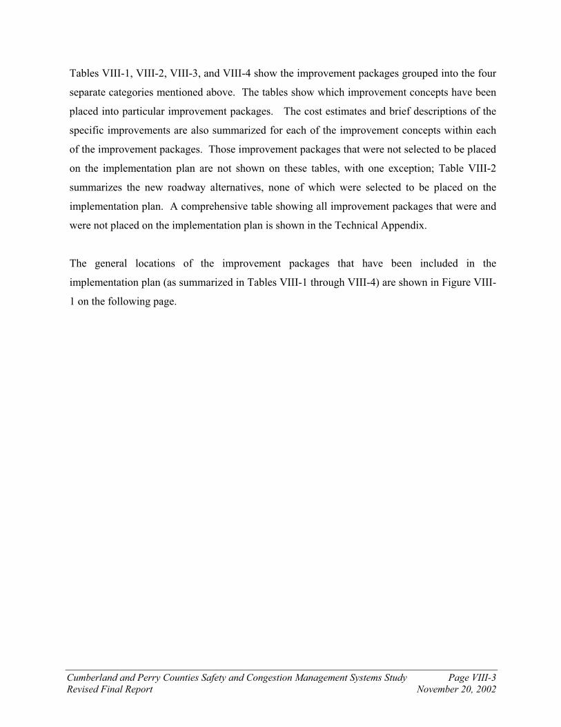
Cumberland and Perry Counties Safety and Congestion Management Systems Study Page VIII-3
Revised Final Report November 20, 2002
Tables VIII-1, VIII-2, VIII-3, and VIII-4 show the improvement packages grouped into the four
separate categories mentioned above. The tables show which improvement concepts have been
placed into particular improvement packages. The cost estimates and brief descriptions of the
specific improvements are also summarized for each of the improvement concepts within each
of the improvement packages. Those improvement packages that were not selected to be placed
on the implementation plan are not shown on these tables, with one exception; Table VIII-2
summarizes the new roadway alternatives, none of which were selected to be placed on the
implementation plan. A comprehensive table showing all improvement packages that were and
were not placed on the implementation plan is shown in the Technical Appendix.
The general locations of the improvement packages that have been included in the
implementation plan (as summarized in Tables VIII-1 through VIII-4) are shown in Figure VIII-
1 on the following page.

General Locations of Proposed Improvements on Implementation Plan – Overall Map Safety and Congestion Management System Study CUMBERLAND AND PERRY COUNTIES, PENNSYLVANIA
Legend - Improvement package code number for:
Capacity and safety improvements
Betterment projects
Related projects outside study area
34-D
34-C
34-A
944-A
274-A
11-F
11-E
849-B
11-A
11-A
944-B
944-D
944-Out
11-A
11-F
944-Out
Figure VIII-1
11-F

Improvement
Package
Location
NumberLocation
Affected
Corridors
Affected
Municipalities
Type of
ImprovementSpecific Improvement
Potential
Funding
Sources
Total
Approximate
Costs
Approximate
Costs -
Design
Approximate
Costs -
Right-of-Way
Approximate
Costs -
Construction
Preliminary
Ranking
Placed on
Implemen-
tation Plan
34-A 34-03 PA Route 34 and
Sunnyside Drive (SR 1007)
/ Mountain Road
intersection
PA 34 Carroll, Rye,
Middlesex
Congestion &
Safety
Redesign intersection -
Option A - Intersection
realignment/reconstruct -
possible traffic signal
Federal,
State, Local
$2,500,000 $375,000 $125,000 $2,000,000 1
X
34-A 34-16 PA Route 34 - Between
Shermans Dale Bridge and
Richwine Road
PA 34 Carroll Safety Install two-way center left-
turn lane
Federal,
State
$2,780,000 $417,000 $139,000 $2,224,000 1
X
34-A 34-05 PA Route 34 and Fox
Hollow Road intersection
PA 34 Carroll Safety Install northbound left-turn
lane
Federal,
State
$185,000 $28,000 $0 $157,000 1X
34-A 34-04 PA Route 34 and PA Route
850 intersection (Shermans
Dale)
PA 34, PA
850
Carroll Safety Relocate / reconstruct
shopping center driveways -
install traffic signal
Federal,
State, Local
$700,000 $105,000 $35,000 $560,000 1
X
34-A 34-02 PA Route 34 and Windy
Hill Road (SR 2001)
intersection
PA 34, PA
850
Carroll Congestion &
Safety
Relocate Windy Hill Road to
the southeast - tie in with
Souder Road at new
intersection
Federal,
State
$2,500,000 $375,000 $125,000 $2,000,000 1
X
34-A 34-12 PA Route 34 and Rambo
Hill Road intersection
PA 34 Carroll Safety Install northbound left-turn
lane
Federal,
State
$185,000 $28,000 $9,000 $148,000 1X
$8,850,000 $1,328,000 $433,000 $7,089,000 1 X
944-A 944-01 PA Route 944 - Between PA 944 Middlesex, Silver Congestion Addition of a two-way center Federal, $14,000,000 $2,100,000 $700,000 $11,200,000 2 X
944-A 944-04 PA Route 944 and PA
Route 114 intersection
PA 944 Silver Spring Congestion Construct second NB left-
turn lane
Federal,
State
$500,000 $75,000 $25,000 $400,000 2X
$14,500,000 $2,175,000 $725,000 $11,600,000 2 X
Improvement Package 34-A Total:
Improvement Package 944-A Total:
Table VIII-1
CAPACITY AND SAFETY IMPROVEMENT PACKAGES IN THE STUDY AREA
(Sorted by Preliminary Ranking)
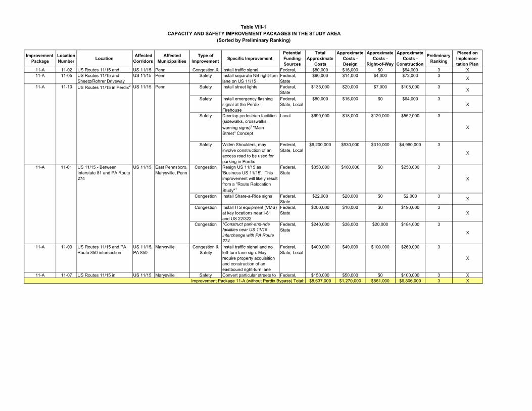
Improvement
Package
Location
NumberLocation
Affected
Corridors
Affected
Municipalities
Type of
ImprovementSpecific Improvement
Potential
Funding
Sources
Total
Approximate
Costs
Approximate
Costs -
Design
Approximate
Costs -
Right-of-Way
Approximate
Costs -
Construction
Preliminary
Ranking
Placed on
Implemen-
tation Plan
Table VIII-1
CAPACITY AND SAFETY IMPROVEMENT PACKAGES IN THE STUDY AREA
(Sorted by Preliminary Ranking)
11-A 11-02 US Routes 11/15 and US 11/15 Penn Congestion & Install traffic signal Federal, $80,000 $16,000 $0 $64,000 3 X
11-A 11-05 US Routes 11/15 and
Sheetz/Rohrer Driveway
US 11/15 Penn Safety Install separate NB right-turn
lane on US 11/15
Federal,
State
$90,000 $14,000 $4,000 $72,000 3X
11-A 11-10 US Routes 11/15 in Perdix2 US 11/15 Penn Safety Install street lights Federal,
State
$135,000 $20,000 $7,000 $108,000 3X
Safety Install emergency flashing
signal at the Perdix
Firehouse
Federal,
State, Local
$80,000 $16,000 $0 $64,000 3
X
Safety Develop pedestrian facilities
(sidewalks, crosswalks,
warning signs)2 "Main
Street" Concept
Local $690,000 $18,000 $120,000 $552,000 3
X
Safety Widen Shoulders, may
involve construction of an
access road to be used for
parking in Perdix
Federal,
State, Local
$6,200,000 $930,000 $310,000 $4,960,000 3
X
11-A 11-01 US 11/15 - Between
Interstate 81 and PA Route
274
US 11/15 East Pennsboro,
Marysville, Penn
Congestion Resign US 11/15 as
'Business US 11/15'. This
improvement will likely result
from a "Route Relocation
Study"1
Federal,
State
$350,000 $100,000 $0 $250,000 3
X
Congestion Install Share-a-Ride signs Federal,
State
$22,000 $20,000 $0 $2,000 3X
Congestion Install ITS equipment (VMS)
at key locations near I-81
and US 22/322
Federal,
State
$200,000 $10,000 $0 $190,000 3
X
Congestion *Construct park-and-ride
facilities near US 11/15
interchange with PA Route
274
Federal,
State
$240,000 $36,000 $20,000 $184,000 3
X
11-A 11-03 US Routes 11/15 and PA
Route 850 intersection
US 11/15,
PA 850
Marysville Congestion &
Safety
Install traffic signal and no
left-turn lane sign. May
require property acquisition
and construction of an
eastbound right-turn lane
Federal,
State, Local
$400,000 $40,000 $100,000 $260,000 3
X
11-A 11-07 US Routes 11/15 in US 11/15 Marysville Safety Convert particular streets to Federal, $150,000 $50,000 $0 $100,000 3 X
$8,637,000 $1,270,000 $561,000 $6,806,000 3 XImprovement Package 11-A (without Perdix Bypass) Total:
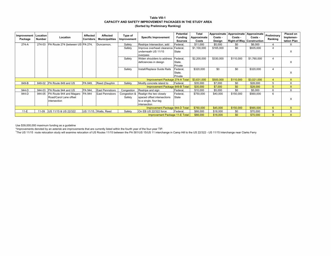
Improvement
Package
Location
NumberLocation
Affected
Corridors
Affected
Municipalities
Type of
ImprovementSpecific Improvement
Potential
Funding
Sources
Total
Approximate
Costs
Approximate
Costs -
Design
Approximate
Costs -
Right-of-Way
Approximate
Costs -
Construction
Preliminary
Ranking
Placed on
Implemen-
tation Plan
Table VIII-1
CAPACITY AND SAFETY IMPROVEMENT PACKAGES IN THE STUDY AREA
(Sorted by Preliminary Ranking)
274-A 274-03 PA Route 274 (between US PA 274, Duncannon, Safety Restripe Intersection, add Federal, $11,000 $5,000 $0 $6,000 4 X
Safety Improve overhead clearance
underneath US 11/15
overpass
Federal,
State
$1,100,000 $165,000 $0 $935,000 4
X
Safety Widen shoulders to address
deficiencies in design
Federal,
State,
Private
$2,200,000 $330,000 $110,000 $1,760,000 4
X
Safety Install/Replace Guide Rails Federal,
State,
Private
$320,000 $0 $0 $320,000 4
X
$3,631,000 $500,000 $110,000 $3,021,000 4 X
849-B 849-02 PA Route 849 and US PA 849, Reed (Dauphin Safety Modify concrete island to Federal, $35,000 $7,000 $0 $28,000 5 X
$35,000 $7,000 $0 $28,000 5 X
944-D 944-03 PA Route 944 and US PA 944, East Pennsboro Congestion Restripe and sign Federal, $10,000 $5,000 $0 $5,000 6 X
944-D 944-05 PA Route 944 and Magaro
Road/Carol Lane offset
intersection
PA 944 East Pennsboro Congestion &
Safety
Realign the two closely
spaced offset intersections
to a single, four-leg
intersection
Federal,
State
$750,000 $40,000 $150,000 $560,000 6
X
$760,000 $45,000 $150,000 $565,000 6 X
11-E 11-09 US 11/15 & US 22/322 US 11/15, Watts, Reed Safety On EB US 22/322 force Federal, $88,000 $18,000 $0 $70,000 9 X
$88,000 $18,000 $0 $70,000 9 X
Use $39,000,000 maximum funding as a guideline
*Improvements denoted by an asterisk are improvements that are currently listed within the fourth year of the four-year TIP.
Improvement Package 274-A Total:
1The US 11/15 route relocation study will examine relocation of US Routes 11/15 between the PA 581/US 15/US 11 interchange in Camp Hill to the US 22/322 - US 11/15 Interchange near Clarks Ferry
Improvement Package 849-B Total:
Improvement Package 944-D Total:
Improvement Package 11-E Total:

Improvement Packages Not Placed on Implementation Plan
Improvement
Package
Location
NumberLocation
Affected
Corridors
Affected
Municipalities
Type of
ImprovementSpecific Improvement
Potential
Funding
Sources
Total
Approximate
Costs
Approximate
Costs -
Design
Approximate
Costs -
Right-of-Way
Approximate
Costs -
Construction
Preliminary
Ranking
Placed on
Implemen-
tation Plan
11-A (Perdix
Bypass)
(Alternative C)
11-10 US Routes 11/15 in Perdix US 11/15 Penn Congestion &
Safety
Where widening not
possible on existing US
11/15 in Perdix, new
sections will be built as a
bypass (new roadway)
Federal,
State
$61,000,000 $9,150,000 $1,000,000 $50,850,000 12
$61,000,000 $9,150,000 $1,000,000 $50,850,000 12
11-H
(Alternative B)
11-01 US 11/15 - Between
Interstate 81 and PA Route
274
US 11/15 East Pennsboro,
Marysville, Penn
Congestion Construct new roadway -
Parallel to US 11/15
Federal,
State
$310,000,000 $46,500,000 $5,500,000 $258,000,000 18
$310,000,000 $46,500,000 $5,500,000 $258,000,000 18
34-E
(Alternative A)
34-14 Parallel to PA 34 (between
Mecks Corner and PA 944
at PA 114)
PA 34, PA
850, PA
944
Wheatfield,
Carroll, Rye,
Middlesex, Silver
Spring
Congestion Construct new roadway -
Parallel to PA 34
Federal,
State
$260,000,000 $39,000,000 $3,000,000 $218,000,000 19
$260,000,000 $39,000,000 $3,000,000 $218,000,000 19
Use $39,000,000 maximum funding as a guideline
Improvement Package 11-A (with Perdix Bypass) Total:
Improvement Package 11-H Total:
Improvement Package 34-E Total:
Table VIII-2
NEW ROADWAYS IN THE STUDY AREA
(Sorted by Preliminary Ranking)
Improvement
Package
Location
NumberLocation
Affected
Corridors
Affected
Municipalities
Type of
ImprovementSpecific Improvement
Potential
Funding
Sources
Total
Approximate
Costs
Approximate
Costs -
Design
Approximate
Costs -
Right-of-Way
Approximate
Costs -
Construction
Preliminary
Ranking
Placed on
Implemen-
tation Plan
11-F 11-04 US Routes 11/15 (at
Kinkora heights - between
PA 274 and Cove Road)
US 11/15 Penn Safety Provide protection from rock
falls
Federal,
State
$250,000 $35,000 $5,000 $210,000 7
X
11-F* 11-12 US Routes 11/15 (at the
Cumberland/Perry border)
US 11/15 East Pennsboro,
Marysville, Penn
Safety *Provide protection from
rock falls
Federal,
State
$495,000 $45,000 $9,000 $441,000 7
X
$745,000 $80,000 $14,000 $651,000 7 X
944-B 944-08 PA Route 944 and Lambs
Gap Road (SR 1011)
PA 944 Hampden Safety Sight distance improvements
- Flatten crest vertical curve
adjacent to intersection
Federal,
State
$580,000 $36,000 $80,000 $464,000 8
X
$580,000 $36,000 $80,000 $464,000 8 X
34-C 34-06 PA Route 34 / SR 2006 /
Dellville Road (SR 2002) -
S Mecks Corner Int
PA 34, PA
274
Carroll,
Wheatfield
Safety Restripe Intersection Federal,
State
$12,000 $5,000 $0 $7,000 10
X
34-C 34-08 PA 34 and Barnett Road
intersection
PA 34, PA
274
Centre, New
Bloomfield
Safety Sight distance improvements
- Realign horizontal and
vertical curves
Federal,
State
$400,000 $60,000 $20,000 $320,000 10
X
34-C 274-01 PA Route 274 and SR 2006
(PA Route 274 connector) -
Eastern intersection of
Mecks Corner
PA 274 Carroll,
Wheatfield
Safety Flatten crest vertical curve
and lessen skew angle of
intersection to improve sight
distance
Federal,
State
$500,000 $75,000 $25,000 $400,000 10
X
$912,000 $140,000 $45,000 $727,000 10 X
34-D 34-09 PA 34 and Shortcut Road
(SR 1017) intersection
PA 34 Howe Safety Sight distance improvements
- Cut back embankment -
install retaining wall
Federal,
State
$57,000 $9,000 $2,000 $46,000 11
X
34-D 34-10 PA 34 and Juniata Parkway
(SR 1015)
PA 34 Howe Safety Sight distance improvements
- Modifications to bridge
Federal,
State
$180,000 $27,000 $0 $153,000 11
X
$237,000 $36,000 $2,000 $199,000 11 X
Use $39,000,000 maximum funding as a guideline
*Improvements denoted by an asterisk are improvements that PENNDOT is currently examining or are currently on the TIP.
Improvement Package 944-B Total:
Improvement Package 34-C Total:
Improvement Package 34-D Total:
Table VIII-3
BETTERMENT PROJECTS IN THE STUDY AREA
(Sorted by Preliminary Ranking)
Improvement Package 11-F Total:

Improvement
Package
Location
NumberLocation
Affected
Corridors
Affected
Municipalities
Type of
ImprovementSpecific Improvement
Potential
Funding
Sources
Total
Approximate
Costs
Approximate
Costs -
Design
Approximate
Costs -
Right-of-Way
Approximate
Costs -
Construction
Preliminary
Ranking
Placed on
Implemen-
tation Plan
11-A 11-01 US 11/15 - Between
Interstate 81 and PA Route
274
US 11/15 East Pennsboro,
Marysville, Penn
Congestion Resign US 11/15 as
'Business US 11/15'. This
improvement will likely result
from a "Route Relocation
Study"1
Federal,
State
$350,000 $100,000 $0 $250,000 3
X
PA Route 114 and I-81 NB
Ramps and SB Ramps
Intersections
PA 944,
I-81
Silver Spring Congestion &
Safety
Increased traffic flow from
PA 944 and Perry County
may cause congestion.
Examine adequacy of
capacity, queuing storage,
and traffic flow progression
at these signalized
intersections.
N/A N/A N/A N/A N/A N/A
PA Route 114 between I-81
and PA Route 944
PA 944,
I-81
Silver Spring Congestion &
Safety
Increased traffic flow from
PA 944 and Perry County
may cause congestion.
Examine adequacy of the
capacity of this two-lane
section of PA 114.
N/A N/A N/A N/A N/A N/A
Use $39,000,000 maximum funding as a guideline
It will also examine the potential financial impact of a route re-designation to business that exist along the US Routes 11/15 corridor and it will examine the prohibition of through trucks from US 11/15
1The US 11/15 route relocation study will examine relocation of US Routes 11/15 between the PA 581/US 15/US 11 interchange in Camp Hill to the US 22/322 - US 11/15 Interchange near Clarks Ferry
Table VIII-4
RELATED PROJECTS OUTSIDE STUDY AREA
(Sorted by Preliminary Ranking)
944-OUT N/A

Cumberland and Perry Counties Safety and Congestion Management Systems Study Page VIII-11
Revised Final Report November 20, 2002
B. Estimated Improvement Cost
Preliminary cost estimates were conducted for each proposed improvement concept and each
improvement package. The estimates examined the length of the roadway and a proposed
typical section to develop a total cost for each improvement. The total cost for each
improvement concept was calculated taking into consideration the design costs and the right-of-
way costs. The design costs were assumed to be a percentage of total construction costs. Right-
of-way costs were determined based on the estimate of the amount of actual land needed. The
calculations and assumptions used to arrive at the total cost estimates for each improvement
project are shown on the table titled “Improvement Concepts – Cost Estimates”, which is located
in the Technical Appendix. The cost estimates for each improvement package are shown on
Table VIII-5. The total cost of the implementation program is estimated to be nearly $39
million.
Table VIII-5 SUMMARY OF COST ESTIMATES FOR IMPROVEMENT PACKAGES
IN THE IMPLEMENTATION PLAN
Approximate Cost Improvement Package
Category Total Design Right-of-Way Construction
34-A C & S $8,850,000 $1,328,000 $433,000 $7,089,000
944-A C & S $14,500,000 $2,175,000 $725,000 $11,600,000
11-A C & S $8,637,000 $1,270,000 $561,000 $6,806,000
274-A C & S $3,631,000 $500,000 $110,000 $3,021,000
849-B C & S $35,000 $7,000 $0 $28,000
944-D C & S $760,000 $45,000 $150,000 $565,000
11-F Bet $745,000 $80,000 $14,000 $651,000
944-B Bet $580,000 $36,000 $80,000 $464,000
11-E C & S $88,000 $18,000 $0 $70,000
34-C Bet $912,000 $140,000 $45,000 $727,000
34-D Bet $237,000 $36,000 $2,000 $199,000
C & S = Capacity and Safety Bet = Betterment
Regarding the assumptions used in developing the cost estimates, it should be noted that the
estimates are planning level estimates. More detailed cost estimates will have to await the
development of more detailed engineering designs. Further, it should also be recognized that
individual improvement proposals might have to be modified somewhat as engineering proceeds.
It is also possible that alternate schemes may be developed in the course of engineering, further

Cumberland and Perry Counties Safety and Congestion Management Systems Study Page VIII-12
Revised Final Report November 20, 2002
refining the cost estimates. The estimated costs are reflective of 2002 construction costs, and the
calculations and the assumptions used in the cost estimates are shown in the Technical
Appendix.
C. Improvement Packages Included in the Implementation Plan
Because projects cannot successfully be implemented without adequate funding, a rough
maximum funding limit of $39 million was assumed for all implemented projects in the study
area. The tables (VIII-1 through VIII-4) shown on the previous pages show the improvement
packages that will be placed on the implementation plan. Table VIII-6, which is shown below,
shows the aggregate cost for all of the improvement packages based upon the preliminary
ranking.
Table VIII-6 SUMMARY OF COST ESTIMATES FOR THE IMPLEMENTATION PLAN
Improvement Package Preliminary
Rank Number Estimate of Total Cost
Improvement Package Ranked as #1 $8,850,000
Improvement Packages Ranked 1-2 $23,350,000
Improvement Packages Ranked 1-3 $31,987,000
Improvement Packages Ranked 1-4 $35,618,000
Improvement Packages Ranked 1-5 $35,653,000
Improvement Packages Ranked 1-6 $36,413,000
Improvement Packages Ranked 1-7 $37,158,000
Improvement Packages Ranked 1-8 $37,738,000
Improvement Packages Ranked 1-9 $37,826,000
Improvement Packages Ranked 1-10 $38,738,000
Improvement Packages Ranked 1-11 $38,975,000
Improvement Packages Ranked 1-12 $99,975,000
Improvement Packages Ranked 1-13 $110,975,000
Improvement Packages Ranked 1-14 $131,855,000
Improvement Packages Ranked 1-15 $164,155,000
Improvement Packages Ranked 1-16 $167,905,000
Improvement Packages Ranked 1-17 $169,025,000
Improvement Packages Ranked 1-18* $418,025,000
Improvement Packages Ranked 1-17 and 19 $429,025,000 Items in boldface are being placed on the implementation plan. *Improvement Package Ranking 18 involves the construction of a new bypass parallel to US 11/15. With this new roadway, a bypass around Perdix will not be necessary. Use $39,000,000 maximum funding guideline
Cumberland and Perry Counties Safety and Congestion Management Systems Study Page VIII-13
Revised Final Report November 20, 2002
A natural cutoff exists after the 11th ranked project; after this point, the addition of extra projects
becomes increasingly expensive. The lower-ranked improvement packages are generally those
that contain projects that have benefits that do not justify the costs (greater than $260 million).
The new roadways (bypasses) were not included on the implementation plan because the new
highways only solve the congestion problems on roadways to which they are parallel. Most
safety problems would still exist, even with the construction of the new roadways. For the
projected cost of a new roadway over the mountainous terrain, the new bypass should be an
effective solution. As previously stated, the new bypasses are not an effective solution because
the projected 20-year traffic volumes do not put the most heavily traveled existing roadways over
capacity, and it is a fact that there are limited financial resources; a different strategy in
investment will make better use of the funds in order to solve the safety and congestion problems
that exist and are projected to occur in the study area. The new roadway alternatives would not
solve many of the sight distance related safety problems that currently exist on the study area
roadway corridors. The other similarly expensive, low-benefit improvement packages are
ranked low and have not been included in the implementation plan.
The general locations of the improvement packages that have been included in the
implementation plan are shown in Figure VIII-1 on page VIII-4, which accompanies Tables
VIII-1 through VIII-4 on the previous pages.
D. Sequencing of the Improvement Packages within the Implementation Plan The preliminary rankings should be used as a guide when determining the sequencing of the
implementation of the improvement packages. Improvement package 944-A should be
implemented immediately after the number one ranked improvement package (34-A). This
sequencing is necessary to ensure that the additional capacity that is added to the roadways to
help shuttle high volumes of traffic up and over Sterretts Gap (with the implementation of
improvement package 34-A) does not allow motorists to encounter a bottleneck at an
unimproved, single-lane PA Route 944. It is important to consider the order of implementation
when performing the programming of the improvement packages. The remainder of the
improvement packages should be implemented using the preliminary rankings as a guide.

Cumberland and Perry Counties Safety and Congestion Management Systems Study Page VIII-14
Revised Final Report November 20, 2002
Improvement package 944-OUT, which is located outside the study area, should be considered
concurrently with improvement package 944-A. The intersection of PA Route 114 and the I-81
ramps, which is located outside the borders of the study area, currently experiences capacity
problems, and the problems are expected to worsen in the future. The additional capacity that is
added along PA Route 34 (in Perry County) and PA Route 944 (between PA Route 114 and
Sunnyside Drive) should not experience a bottleneck at the PA Route 114 / I-81 ramps
intersection. Additionally, a bottleneck should not occur along the existing two-lane section of
PA Route 114 between I-81 and PA Route 944; this section of PA Route 114 should also be
placed in improvement package 944-OUT (and should be examined concurrently with
improvement package 944-A). Likewise, the re-signing of US Routes 11/15 between US Routes
22/322 and I-81 as Business 11/15, as it is proposed, will likely need to be a part of a more large-
scale route relocation study. The route relocation study would also need to include a business
impact survey that will determine the financial repercussions of re-signing US Routes 11/15.
The route relocation study limits would use the PA Route 581 - US Routes 11/15 interchange in
Camp Hill as its southern end and the US Routes 22/322 – US Routes 11/15 interchange in
Clarks Ferry as its northern limit.
The first six improvement packages that should be implemented are as follows (shown in
sequential order):
1. 34-A
2. 944-A
3. 11-A
4. 274-A
5. 849-B
6. 944-D

Cumberland and Perry Counties Safety and Congestion Management Systems Study Page VIII-15
Revised Final Report November 20, 2002
E. Implementation Plan Responsibility and Funding (Strategies for Implementation) With the development of a comprehensive improvement program, the closely related question of
phasing and funding can be addressed. Key questions to be addressed are:
¶ What level of funding can be expected from the state and federal government?
¶ How and to what level can (or will) the local government fund some local share of the improvement package?
¶ What role will the private sector play?
Clearly, the pace of the implementation plan will be dictated by the availability of funding.
Further, it is also clear that many of these questions will not be fully answered within the time
frame of this study. Therefore, as a first step, the Task Force should remain “convened” and
active in seeking the answers to these key questions. It is possible that the Task Force may need
to be expanded to include members of the development community or other groups or agencies.
As before, the goal of the Task Force must always be the improvement of the transportation
picture within the goals of the community.
The second step is the assignment of funding responsibilities for the various projects. Normally,
for state highways, the major source of funds has traditionally been PENNDOT and the federal
government. However, there is strong competition for the limited amount of funds available and
PENNDOT is searching for ways to “stretch” their funds to address their needs.
It is anticipated that the funding responsibility of the local municipalities for most of the
improvement packages will be minimal because all of the improvement packages involve
improvements to state-maintained roadways. However, a number of traffic signals are
recommended for installation in certain municipalities. Traditionally, municipalities (or
developers) are responsible for the funding of the installation of traffic signals. However, if a
PENNDOT project is planned for a roadway, and if a traffic signal is required or asked for by the
municipality during design, then PENNDOT will fund the construction of the signal. The
improvement packages included in this implementation plan can be used as a means of obtaining
Cumberland and Perry Counties Safety and Congestion Management Systems Study Page VIII-16
Revised Final Report November 20, 2002
PENNDOT funding for the construction of traffic signals thereby saving money for financially-
strapped municipalities. Even if PENNDOT pays for the construction of the signal, the
municipalities will still be responsible for funding of regular maintenance, which costs
approximately $200 to $750 per year per signal (depending on the age of the equipment).
Portions of improvement package 11-A, which includes the “Main Street” concept on US Routes
11/15 in Perdix and Marysville, will likely not receive all of its funding through the traditional
80% federal / 20% state funding formula. Because of the nature of the proposed improvements,
especially the “Main Street” concept, improvement package 11-A will likely be eligible for
additional grants such as “Main Street” grants, Pennsylvania Department of Economic and
Community Development (DECD) grants, the Susquehanna Greenway Trail funding, and other
similar grants and funding. Additionally, funding for this improvement package will be part of
the MPO (Metropolitan Planning Organization) process, and as such, a management agency will
be needed to take the lead in order to implement the grants and to determine where each dollar is
spent. The “Main Street” concept for US Routes 11/15 is explained in detail in Chapter VI and
Chapter IX; the public response to this concept (from the October 30, 2002 public meeting) is
also summarized in Chapter IX.
For this study, the opportunity to join forces with the private sector to obtain funding exists for
the improvement package recommended for the eastern end of PA Route 274. The Perry County
Business Campus One, which is located adjacent to PA Route 274 in Penn Township, is slated
for development by private developers in the immediate future. Because this land will likely be
developed as light industrial and office space, there will be definite traffic impacts to PA Route
274 between the business campus and US Routes 11/15. Given this situation, it is recommended
that a “partnership” between the public and the private sectors be explored. Such a partnership
would be more effective in securing federal and state funding for the improvement packages.
Public sector funding of highway projects is typically accomplished through the Twelve-Year
Transportation Program that is managed cooperatively by the Tri-County Regional Planning
Commission and the Pennsylvania Department of Transportation. The Twelve-Year
Transportation Program is a fiscally constrained listing of transportation projects that are

Cumberland and Perry Counties Safety and Congestion Management Systems Study Page VIII-17
Revised Final Report November 20, 2002
expected to utilize federal and/or state transportation funds during the twelve-year period. The
Twelve-Year Program is divided into three, four-year periods. After the three county planning
commissions (Cumberland, Dauphin, and Perry) and the Tri-County Regional Planning
Commission (TCRPC), in a joint effort with local municipal governments, review and make
recommendations for project priorities to be considered in the program, the program is reviewed
and then approved by the Harrisburg Area Transportation Study (HATS). Finally, the program
becomes effective once it is adopted by the State Transportation Commission (STC) and then
lastly by the Federal Highway Administration (FHWA). This process occurs every two years
and represents the process by which the region decides to spend transportation dollars.
It is recommended that each improvement package be placed on the Twelve-Year Program as an
individual line item so it can be tracked. However, to meet the requirements of the National
Environmental Policy Act (NEPA) and the Clean Water Act (Section 404) at the federal level
and the procedures of the Pennsylvania Department of Transportation established pursuant to
State Law, certain improvement packages must obtain specific levels of environmental
clearance. This process requires additional engineering and alternative analyses and
environmental studies. These studies must also be listed on the Twelve-Year Program. It is in
this part of the project development process that all alternates are evaluated and preliminary
engineering occurs. The next step is the preparation of construction drawings and acquisition of
the required right-of-way.
Strategies for Implementation
The outline below summarizes the strategies for implementation of the recommended
improvement packages:
1. Continue to hold periodic meetings and maintain the Cumberland and Perry Counties Joint Task Force on Transportation and Planning (CPTF) – this will sustain credibility as a working regional group
a. Monitor land development in the study area and the growth in traffic volumes in
order to maintain validity of the recommended improvements – this can be accomplished by using the results of the optimistic scenario (in Chapter VII of this document) as a guide

Cumberland and Perry Counties Safety and Congestion Management Systems Study Page VIII-18
Revised Final Report November 20, 2002
b. Continued communication between members of the CPTF to identify other needs as they arise
2. Presentation of the recommended improvements to the HATS Technical Committee in
January or February 2003
a. Continued CPTF presence at HATS meetings
3. Placement of improvement packages into local/regional transportation plans
a. Regional Transportation Plan (update is currently underway) – December 2003 completion
b. Congestion Management System Plan (update currently underway) – December
2002 completion
c. County Comprehensive Plans – updates currently underway
d. Transportation Improvement Program (TIP) – next update begins May 2003
e. Presentation to State Transportation Commission (STC) – possibly Fall 2003 4. Funding – other than the region’s base allocation (which is the most competitive)
a. Earmarked funds – work with area legislators to get funds assigned to the recommended improvement packages
b. Overmatch – Provide ‘local’ funds (municipal, state or federal sources) for the
local match in excess of the minimum 20% matching funds typically required for projects
5. Federal (base allocation) funds
a. Submit application to HATS (as a regional group – CPTF) – sample applications are located in the Appendix of this document
b. Municipalities should add letters of support to application
c. Municipalities must balance priorities for their more local projects and support of
the CPTF recommended improvement packages 6. State Betterment Funds
a. Follow PENNDOT procedures
Cumberland and Perry Counties Safety and Congestion Management Systems Study Page VIII-19
Revised Final Report November 20, 2002
It should be noted that the recommended improvement packages should have the full support of
the CPTF in order for HATS to give the projects a higher priority in their ranking system. The
recommended improvement packages from this study will be competing with other
transportation improvement projects in the Harrisburg region, which includes all of Cumberland,
Dauphin, and Perry Counties, Fairview Township in York County, and Palmyra Borough and
North Londonderry Township in Lebanon County. The HATS Technical Committee takes input,
evaluates the project proposals, and passes on their recommended priority list to the HATS
Coordinating Committee. The HATS coordinating committee makes the final decisions on
which projects get selected and the final rankings of the HATS priority list. The higher priority
projects, as determined by HATS, will compete with other transportation improvement projects
from the Harrisburg region in order to be placed on the Transportation Improvement Program
(TIP).
A sample project suggestion form (application) that is submitted to HATS has been completed
for each improvement package that has been placed on the implementation plan; the sample form
is located in the Appendix at the end of this document. Additionally, the project ranking criteria
that is used by the HATS Technical Committee is also included in the Appendix at the end of
this document.
F. Coordination Certain areas that have been identified in this study as locations where improvement projects are
needed are currently being examined or are planned to be examined by PENNDOT. These areas
include the Duncannon Subway, the Shermans Dale Bridge (near Windy Hill Road on PA Route
34), the park-and-ride lot at the PA Route 274 interchange with US Routes 11/15, and US Routes
22/322 in Clarks Ferry. It is important that the local municipalities that are affected by these
projects and any future projects are contacted and coordinated with early on in the project
development / design process. The PENNDOT project manager for any transportation
improvement project should be responsible for contacting the local municipalities early in the
project development and design process. This will ensure that all parties are made aware of any
improvement projects, and it will prevent any conflicting plans for improvements before it is too
late in the design process.

Cumberland and Perry Counties Safety and Congestion Management Systems Study Page VIII-20
Revised Final Report November 20, 2002
It is also important for the study area municipalities to coordinate with TCRPC in issues related
to transportation planning and automobile trip-reducing initiatives. Although transit may not be
a cost-effective option for the rural, low-density nature of Perry County, many vehicles can be
taken off of the congested study area roadways during the peak periods through ride-sharing or
carpooling incentives. With the availability of new park and ride lots in the study area, and the
proposed construction of a new park and ride lot near the PA Route 274 and US Routes 11/15
interchange near Duncannon, carpooling and ride-sharing should become easier and should be a
priority for the study area municipalities. The local municipalities should coordinate with each
other and with TCRPC regarding the TCRPC carpool initiative.
Other non-traditional methods of reducing congestion also need to be implemented along with
any physical transportation improvements in order to lengthen the service life of the
implemented improvements. The non-traditional methods, which are also listed in the
Congestion Management System Screening Process in Chapter VI, include but are not limited to
the following strategies: congestion pricing, flex time, telecommuting, increased ride-sharing
and transit use, and intelligent transportation systems. These congestion management strategies,
if implemented properly, will lengthen the service life of any physical capacity improvement and
could even delay the need for additional physical capacity improvements (i.e., more lanes).
G. Next Steps In addition to maintaining the Task Force and executing the strategies for implementation, the
next steps listed below should be conducted to help reach successful completion of the program.
1. Program and fund improvement packages. 2. Continue to examine environmental constraints within the recommended improvement
areas. Mitigate all historical and environmental impacts and secure the necessary clearances.
3. Finalize roadway alignments and prepare construction plans.
4. Secure necessary right-of-way to complete each improvement. Develop zoning
initiatives to keep prospective important locations from being commercialized or detrimental to the proposed implementation plan.

Cumberland and Perry Counties Safety and Congestion Management Systems Study Page VIII-21
Revised Final Report November 20, 2002
5. Construct the improvement packages within the necessary time frame to have all
improvements completed by the year 2020. H. Potential Long-Term Projects (Beyond Year 2020)
The design year for this study is the year 2020. The recommended improvements that are
included within this report will be to handle the year 2020 projected peak hour traffic, and the
improvements will actually be able to handle optimistic projections of peak hour traffic in the
year 2020, as shown in Chapter VII of this document. Because of this, the proposed bypass
roadways for PA Route 34 and US Routes 11/15 were not recommended in this report.
Beyond year 2020, it is possible that the traffic volumes on the main thoroughfares between
Cumberland and Perry Counties will grow to such levels that they are greater than the optimistic
projections. The possibility of bypass roadways in the future should never be totally discounted.
When the long-term future (beyond year 2020) traffic volumes cause recurring traffic congestion
on the improved study area roadways, and all non-traditional congestion management techniques
have been exhausted, the only alternatives available to mitigate the long-term future
transportation problems could be to widen the existing roadways or to build new bypass
roadways. Such long-term transportation projects could include, but are not limited to:
¶ PA Route 34 / PA Route 944 bypass roadway or further widening on PA Route 34 and PA Route 944
¶ US Routes 11/15 bypass roadway or widening on US Routes 11/15
¶ A new roadway that connects PA Route 34 near Sterretts Gap to a new
interchange with I-81. The new interchange with I-81 would be located between US Route 11 (Exit 52) and PA Route 114 (Exit 57).

Cumberland and Perry Counties Safety and Congestion Management Systems Study Page IX-1
Revised Final Report November 20, 2002
CHAPTER IX
PUBLIC INVOLVEMENT SUMMARY
A public involvement program was undertaken as part of the Cumberland and Perry Counties
Safety and Congestion Management Systems Study. The progress and the results of the study
were made available to the public by holding three rounds of public meetings within the study
area. Another public meeting was held at the Perdix Firehouse to gauge the level of public
support for the proposed improvements on US Routes 11/15. At the public meetings, the general
public was able to examine the progress/results of the study and they were permitted to ask
questions of members of the project team. Travel survey questionnaires were distributed at the
first two rounds of public meetings in order to gain a better understanding of the travel habits of
the general population. Questionnaires were also distributed at the Perry County Fair and were
printed in the Sunday edition of the Carlisle Sentinel. This chapter summarizes the public
involvement summary, the public meetings, and the results from the questionnaires that were
distributed. The detailed public involvement information and the detailed summaries of the results
from the surveys can be found in the Technical Appendix.
A. Public Meeting #1
The first public meeting was held at the Silver Spring Fire Company Social Hall in Silver Spring
Township, Cumberland County. The public meeting was held on Thursday, July 19, 2001, from
5:00 PM to 9:00 PM.
The meeting was the first in a series of three public meetings to be held during the duration of
the study. The purpose of the meeting was to present the results of the traffic, planning, and
environmental studies in the existing conditions phase of the project and to solicit public input.
The meeting was held for all interested residents in and around the study area. In addition to
members of the project team, several members of the Task Force were in attendance as well.
There were seventy-six residents in attendance at the public meeting, and they primarily resided
in Silver Spring, Middlesex, and Hampden Townships.

Cumberland and Perry Counties Safety and Congestion Management Systems Study Page IX-2
Revised Final Report November 20, 2002
The meeting was separated into two formats. The first format provided an opportunity for
attendees to review displays showing the results of the study to date, and ask questions of the
staff. During the second format, Michael Hanna (ORA), Susan Blickstein (ORA), and Thomas
Graupensperger (GTS) presented the traffic, planning, and environmental findings from the
existing conditions phase of the project. They also fielded questions raised by the public in
attendance.
As the attendees entered the building, they were signed in, received comment sheets and
literature on the project, and were then directed to view the project plans. There were 23 boards
presented for public display, which included existing traffic volume, level of service, and crash
summary boards for each of the corridors, demographic informational boards, existing land use
boards, and environmental boards which summarized environmental features such as wetlands,
historic resources, agricultural lands, etc.
The presentation commenced with Michael Hanna (Orth-Rodgers & Associates) giving an
introduction to the project, and presenting the traffic analysis to date. Susan Blickstein (Orth-
Rodgers & Associates) then presented the demographic analysis findings. Thomas
Graupensperger (GTS) continued with the existing environmental findings, and Michael Hanna
closed the presentation by opening the floor to questions. The subjects covered by the
presentation were the existing traffic volumes, existing levels of service, crash analysis, existing
demographic / employment analysis, and the environmental overview.
Following the presentation, questions were fielded regarding the project as a whole. Several
persons did not have actual questions, but made comments following the presentation. Some
comments came as a result of the questionnaire that was distributed. A detailed summary of the
question and answer period, and a summary of the public comments are shown in the Technical
Appendix.
A questionnaire was distributed to the attendees of the Tuesday, July 19, 2001 public meeting.
Existing travel patterns, safety problem areas, and traffic conditions were among the items that

Cumberland and Perry Counties Safety and Congestion Management Systems Study Page IX-3
Revised Final Report November 20, 2002
were surveyed in the questionnaire. The transportation survey was also distributed at the Perry
County Fair in August 2001, and it was printed in the Sunday, August 19, 2001 edition of The
Carlisle Sentinel and the Tuesday August 21, 2001 edition of the Sentinel’s free weekly
newspaper distribution in Perry County. One hundred and sixteen total questionnaires were
returned. A list of the questions and a brief summary of the highlights of the answers from the
questionnaire is shown below. Detailed summaries of the questionnaire results are summarized
in the Technical Appendix.
Q1: Where do you live? Forty-two percent of the 116 people surveyed live in the Perry County portion of the study area, 41 percent live in the Cumberland County portion of the study area, and 16 percent of the respondents live outside the study area, but within Cumberland or Perry Counties.
Q2: Where do you work? Thirty-five percent of the respondents work outside the study area, 22 percent work in Cumberland County, and 5 percent work in Perry County.
Q3: Which of the eight study corridors do you take to get to/from work?
(PA Route 34, PA Route 944, US Routes 11/15, PA Route 274, PA Route 850, PA Route 849, Interstate 81, and US Routes 22/322) The majority of respondents take multiple corridors to/from work. Overall, 36 percent of the respondents take PA Route 944, while 27 percent use US Routes 11/15. Twenty-eight percent of the respondents use I-81 while 25 percent use PA Route 34.
Q4: What time do you generally leave home for work?
Twenty-eight percent of the respondents leave home for work between 7:00 AM and 8:00 AM, while 23 percent leave between 6:00 AM and 7:00 AM.
Q5: What time do you generally leave work for home?
Twenty-eight percent of individuals leave work for home between 4:00 PM and 5:00 PM, and 21 percent leave between 5:00 p.m. and 6:00 p.m.
Q6: How long does your commute typically take? Twenty-seven percent of respondents have a one-way commute between 15 minutes and 30 minutes, and 22 percent of persons have a one-way commute between 30 minutes and
Cumberland and Perry Counties Safety and Congestion Management Systems Study Page IX-4
Revised Final Report November 20, 2002
45 minutes. Q7: At what intersection or corridor locations do you experience the greatest traffic delays?
Thirty-five percent of the respondents named US Routes 11/15 as one of the corridors where the greatest delays are experienced and 22 percent of the respondents named Sterretts Gap (Sunnyside Drive and PA Route 34) as another intersection where great delays are experienced. Sixteen percent of the respondents named PA Route 944 as a corridor where the significant delays are experienced.
Q8: In your opinion, what improvements would you like to see implemented to resolve the
traffic congestion problems that were indicated in question #7 above?
Nineteen percent of respondents would like to see the installation of new traffic signals. Locations where persons would like to see the new signals installed include the following: the intersection of PA Route 34 and Sunnyside Drive at Sterretts Gap; PA Route 850 and PA Route 34 (Shermans Dale); and PA Route 944 and US Routes 11/15. Also, 20 percent of respondents would like to see the widening of certain intersections/corridors. Locations where person would like to see widening occur include the following: the intersection of PA Route 34 and Sunnyside Drive at Sterretts Gap; PA Route 944 between PA Route 114 and Sunnyside Drive, as well as the intersection of PA Route 850 and PA Route 34 (Shermans Dale).
Q9: At what intersection or corridor locations do you have safety concerns?
Twenty-eight percent of the respondents named PA Route 944 as one of the corridors with the greatest safety concerns. Specific intersections highlighted along PA Route 944 included PA Route 944 and Deer Lane; PA 944 and Lambs Gap Road; and PA Route 944 and Rich Valley Road. Another 28 percent of the respondents named US Routes 11/15 as one of the corridors with the greatest safety concerns. Specific intersections and segments highlighted along US Routes 11/15 included US Routes 11/15 and PA Route 850; US Routes 11/15 and PA Route 944; US Routes 11/15 between Marysville and Duncannon (Perdix); and US Routes 11/15 and Firehouse Road.
Q10: In your opinion, what are the identifiable problems associated with A. – E. from
question #9 above? Several problems were identified at the intersections and corridor locations mentioned in question 9. Bumper-to-bumper traffic, poor sight distance, stop-and-go traffic, and excessive speeding were the most identifiable problems.
Q11: If it was just a little less convenient (In terms of time and effort) to make your commute
by driving to a park and ride lot and then taking mass transit to work, would you?

Cumberland and Perry Counties Safety and Congestion Management Systems Study Page IX-5
Revised Final Report November 20, 2002
Twenty-eight percent of respondents would drive to the park and ride and take mass transit to work, and 50 percent indicated that they would not take mass transit.
B. Public Meeting #2
The second round of public meetings were held on Tuesday, January 15 and Thursday, January
17, 2002, from 5:00 PM to 9:00 PM. The Tuesday meeting was held at the Duncannon EMS
Social Hall in Penn Township, Perry County, and the Thursday meeting was held at the
Middlesex Elementary School in Middlesex Township, Cumberland County.
These public meetings were the second set in a series of three public meetings. The purpose of
these meetings was to present the preliminary proposed improvements to each of the study area
roadway corridors and to solicit public input. The meeting was held for all interested residents in
and around the study area. In addition to project team personnel, several members of the Task
Force were in attendance as well.
One hundred residents were in attendance (both days combined) and they primarily resided in
Silver Spring, Middlesex, Hampden, and Penn Townships. The evening was separated into two
formats. The first format provided an opportunity for attendees to review displays showing the
results of the study to date, and to ask questions of staff members stationed at the display boards.
During the second format, a presentation was given summarizing the areas of concern and the
preliminary improvement concepts. The completed existing conditions phase of the project was
also summarized in the presentation. Following the presentation, Michael Hanna fielded
questions raised by the public in attendance.
As the attendees entered the building, they were signed in, received comment sheets, literature
on the project, and a questionnaire to complete, and were then directed to view the project plans.
The boards on display included the same environmental and existing traffic conditions boards
that were on display during the first public meeting in July 2001 as well as new display boards
that summarized the preliminary proposed improvements.

Cumberland and Perry Counties Safety and Congestion Management Systems Study Page IX-6
Revised Final Report November 20, 2002
Michael Hanna of Orth-Rodgers & Associates opened the presentation with a brief overview of
the entire project, presented the areas of concern and the preliminary proposed improvement
concepts, and closed the presentation by opening the floor to questions. The subjects covered by
the presentation included the purpose of the public meeting, the overall project process, the areas
of concern, and the recommended improvements for each corridor.
Following the presentations, questions were fielded regarding the presentation and the overall
study. Several people did not have actual questions, but made comments following the
presentation. Some comments came as a result of the questionnaire that was distributed. A
detailed summary of the question and answer period, and a summary of the public comments are
shown in the Technical Appendix.
A questionnaire was distributed to the attendees of both public meetings (the Tuesday, January
15, 2002 meeting and the Thursday January 19, 2002 meeting). Existing travel patterns and
potential improvements to the study area roadways were among the items that were surveyed in
the questionnaire. Forty-six questionnaires were returned from both meetings. A list of the
questions and a brief summary of the highlights of the answers from the questionnaire is shown
below. Detailed summaries of the questionnaire results are summarized in the Technical
Appendix.
Q1: Where do you live? Fifty-two percent of the people surveyed live in Perry County, while 39 percent of respondents indicated that they live in Cumberland County.
Q2: Where do you work?
Fifty-five percent of respondents indicated that they work outside the study area. Twenty-seven percent work in Cumberland County, and 11 percent indicated that they work in Perry County.
Q3: Which of the eight study corridors do you take to get to/from work?
(PA Route 34, PA Route 944, US Routes 11/15, PA Route 274, PA Route 850, PA Route 849, Interstate 81, and US Routes 22/322)
Most people indicated that they take multiple corridors to and from work. Fifty-eight

Cumberland and Perry Counties Safety and Congestion Management Systems Study Page IX-7
Revised Final Report November 20, 2002
percent of respondents indicated that Interstate 81 was traveled to and from work, and 56 percent of those surveyed indicated that PA Route 944 was traveled. Another 37 percent indicated that US Routes 11/15 was traveled, and approximately 35 percent indicated that PA Route 34 was traveled.
Q4: Using the improvement concepts listed below (A-H), please rank what you think would
be the most effective improvement(s) for each roadway corridor for each time frame listed. (In order from your favorite to your least favorite). A. Repave Road D. Widen Intersection G. Retime/Improve Signal B. Widen Road E. Build New Parallel Roadway H. Other: C. Widen Shoulders F. Install Traffic Signal
Note: Each percentage is based upon the response for a particular corridor rather than total number of surveys returned. Multiple responses were allowed for the following questions. Q4a. Short-term Improvements PA Route 34 (17 respondents)
Approximately 65 percent of respondents would like to see PA Route 34 roadway widened, and about 65 percent of respondents feel that installing a new traffic signal would be an effective improvement. Fort-seven percent of the total surveyed would like the shoulders of PA Route 34 widened.
PA Route 944 (21 respondents) Approximately 62 percent of those responding would like the PA Route 944 roadway widened, and 57 percent would like the shoulder widened. Thirty-eight percent believe that there are specific intersections that need to be widened. US Routes 11/15 (15 respondents) 60 percent would like US Routes 11/15 widened, and 60 percent would also like the shoulders widened. Another 60 percent would like to see a new parallel roadway built.
Q4b. Mid-term Improvements
PA Route 34 (9 respondents) Thirty-three percent of the respondents would like the PA Route 34 roadway widened, while another 33 percent suggest that widening the shoulders would be an effective mid-term improvement and that they would like specific intersections widened.
Cumberland and Perry Counties Safety and Congestion Management Systems Study Page IX-8
Revised Final Report November 20, 2002
PA Route 944 (12 respondents) 50 percent of those responding believe that widening the shoulders along PA Route 944 would be an effective mid-term improvement, and about 42 percent of the respondents would like to see the roadway repaved. Another 42 percent believe that widening the roadway and / or widening intersections would be an effective improvement. US Routes 11/15 (6 respondents) Almost 67 percent of the persons responding to this question believe that widening US Routes 11/15 would be an effective mid-term improvement, while another 67 percent suggest building a new parallel roadway. Fifty percent suggested installing traffic signals. Q4c. Long-term Improvements
PA Route 34 (15 respondents) Sixty percent of the respondents would like to see a new parallel roadway built adjacent to PA Route 34, and about 27 percent believe that widening the roadway and / or the shoulders would be an effective long-term improvement. PA Route 944 (10 respondents) Sixty percent of the respondents would like to see the shoulders along PA Route 944 widened. Fifty percent believe that widening specific intersections would be an effective long-term improvement. Forty percent of those surveyed would like the roadways widened. US Routes 11/15 (10 respondents) Sixty percent of the persons that responded would like to see a new parallel roadway built as a long-term improvement, and 40 percent believe that the roadway needs to be widened. Twenty percent would like to see the installation of a new traffic signal.
Q5: How did you find out about tonight’s meeting?
Sixteen percent of the respondents found out about the meeting through the Harrisburg Patriot News, while 15 percent read about the meeting in the Sentinel Newspaper. Fifteen percent of persons heard about the meeting through neighbors and friends or their local municipality newsletters. Fifty-four percent of individuals did not respond to this question.
Cumberland and Perry Counties Safety and Congestion Management Systems Study Page IX-9
Revised Final Report November 20, 2002
C. Public Meeting #3
The third round of public meetings were held on Monday, September 9 and Tuesday, September
10, 2002, from 7:00 PM to 9:00 PM. A meeting with the public officials from the study area will
be held immediately before the public meeting (at 5:00 PM) at each location. The Monday
meeting was held at the Green Ridge Elementary School Gymnasium in Hampden Township,
Cumberland County, and the Tuesday meeting was held at the Shermans Dale Fire Company
Social Hall in Carroll Township, Perry County.
The purpose of these meetings was to present the proposed improvement packages for each of
the study area roadway corridors and to solicit public input. The meeting was held for all
interested residents in and around the study area. In addition to ORA and GTS personnel,
several members of the Task Force were in attendance.
There were 40 residents in attendance on the first night of the meetings, and 76 residents present
the second evening. Residents primarily resided in Silver Spring, Middlesex, Carroll, and
Hampden Townships. Public officials arrived prior to the meeting start and had an opportunity
to preview information before it was presented to the public. The evening was separated into
two formats. The first format provided an opportunity for attendees to review displays showing
the results of the study to date, and ask questions of the staff. During the second format, Jeff
Greene, PE, PTOE of Orth-Rodgers & Associates (ORA) presented the improvement packages.
Following the presentation, Jeff Greene fielded questions raised by the public in attendance.
A summary of write-in public comments, comments from the question and answer session, and
comments from the public officials meeting have been summarized below. The detailed
comment forms are located in the Technical Appendix of the revised Final Report.
¶ The short-term safety and congestion improvements outlined in this study most definitely need to be implemented as soon as the money becomes available. Thank you for allowing the public to comment on this study.
¶ Zoning should be mandatory before any of the improvements begin. It appears that

Cumberland and Perry Counties Safety and Congestion Management Systems Study Page IX-10
Revised Final Report November 20, 2002
counties that do not have improvements would undermine suggested improvements. Unregulated development will harm any improvement attempts.
¶ PennDOT is currently working on some of the suggestions you have proposed in your improvement packages. The Shermans Dale Bridge is being redesigned and scheduled for reconstruction in 2005. Also, a study of US 22/322 in Clarks Ferry is underway.
¶ Interstates 81 and 83 are going to take a long time to build. Can we take some of the suggested short-term improvements, but still consider a bypass for 15-20 years from now?
¶ What does the public have to do to get some of the short-term improvements in place now?
PA Route 34
Many residents were concerned about the intersection of PA Route 34 and Sunnyside Drive. The following were some of the comments:
- Eliminate the stop sign on top of the mountain at the intersection of PA Route 34 and
Sunnyside Drive. Instead have a merge lane to accept traffic from Sunnyside Drive onto
PA Route 34. Increase the length of the center turn lane on PA Route 34 to Sunnyside
Drive to accept more than two or three cars. Add an additional lane (right-turn only)
from Pisgah State Road on to PA Route 34 (across from PA Route 850). And, re-connect
Mountain Road to PA Route 34 (on the Perry Side).
- Along PA Route 34, realigning the Sunnyside Drive/Mountain Road/PA Route 34
intersection and installing a traffic signal would be a better solution than either of the
two proposed options. The two proposed options both increase line of sight difficulties
for people traveling north on PA Route 34. Other comments regarding PA Route 34 included the following:
¶ PA Route 34 definitely needs improvement. There are many buses along this corridor controlling the overall traffic flow. PA Route 34 was never designed to have this high volume of traffic. The proposed driveways along PA Route 34 would only add to the problem.
¶ A traffic signal is needed at the intersection of PA Route 850 and PA Route 34. People trying to get out on PA Route 850 from driveways on Pisgah State Road wait for very long periods of time to get out onto the roadway. School buses cross that intersection as well, and there is very poor sight distance.
¶ Consider a turn lane between Fox Hollow Road and Richwine Road. There are many businesses between this stretch of roadway. It seems as though there would be enough room for a third lane.
Cumberland and Perry Counties Safety and Congestion Management Systems Study Page IX-11
Revised Final Report November 20, 2002
¶ Add a short left-turn lane on PA Route 34 south of Rambo Hill Road. This side would need to be widened to align with the northbound left turn lane.
¶ The PA Route 34 overlay project might take care of the embankment at Old Mill Road and PA Route 34.
¶ Was a bypass considered to the west of PA Route 34?
¶ Close the driveway at the Shermans Dale Plaza on PA Route 34 or make the driveway an exit to North PA Route 34. Increase the sight distance on Mill Road and PA Route 34. Redesign the grade on Windy Hill at PA Route 34. Install a traffic signal at Sunnyside Drive and PA Route 34.
¶ Take off the Faculty Road Embankment Project, 274-A.
PA Route 944 Many residents were opposed to constructing a two-way center-left turn lane on PA Route 944 between Sunnyside Drive and PA Route 114. Most of the residents that were opposed to widening PA Route 944 live along the affected stretch of PA Route 944. The following were some of the comments:
- Residents living along Wertzville Road (PA 944) do not want to see this type of widening
take place. This would take the front yards of people living in Cumberland County and
reduce their quality of life. People living in this area do not want to live along a highway
or deal with a lot of traffic.
- Creating a three-lane roadway along PA Route 944 would be dangerous for persons
living along this roadway. Cars constantly pass along this roadway and some persons
have to walk across the street to pick up their mail or bring farm equipment out along the
roadway. A better solution would be to improve the existing two-lane roadway with turn
lanes at select locations.
- Keep PA Route 944 as two lanes. This would eliminate the need for a lot of right-of-way
acquisition. People living along PA Route 944 are very concerned about the affect the
impact widening the road would have on their property. Build turn lanes at key
intersections and install traffic signals to help control the flow and speed of the traffic.
Also, consider widening PA Route 114 from PA Route 944 and I-81.
Other comments regarding PA Route 944 included the following:
¶ A PA Route 114 relief route would be worth the money. Adding traffic signals only contributes to the problems. It seems as though the suggested improvement favor persons living in Perry County, and do nothing for residents living in Cumberland County.

Cumberland and Perry Counties Safety and Congestion Management Systems Study Page IX-12
Revised Final Report November 20, 2002
¶ School buses from Cumberland Valley High School and the Cumberland/Perry Vo-Tech School travel these roads a minimum of twice daily. There are also additional buses transporting students from after school sports and programs. There are safety issues that a three-lane roadway would create.
¶ This seems like a lot of money to spend when installing traffic lights seems like a good solution.
¶ The PA Route 114 corridor is a concern from PA Route 944 to Interstate 81 (I-81). Traffic coming down PA Route 944 from PA Route 34 turns onto PA Route 114 to access I-81. These drivers take I-81 north to 581. This traffic will only increase. PA Route 114 has several problems. The right-turn lane at the top of the ramp from southbound I-81 merges with 114. A YIELD sign governs this. It needs to become a STOP sign. At PA Route 944, PA Route 114 changes from one to two lanes and cars “jockey for position”. Drivers have a hard time positioning themselves to move into the flow of traffic. Crossing PA Route 114, drivers have poor sight distance.
¶ Constructing a passing lane from Sunnyside Drive to PA Route 114 will make this road unsafe for left-turning vehicles. People already pass on the double lines at the Deer Lane intersection when traffic is stopped waiting for oncoming traffic to clear the intersection. Instead of the passing lane, construct left-turn lanes only at key locations such as: Deer Lane, Rich Valley Road, Glendale and Linda. Narrow back down to two lanes in other areas to reduce the risk of a third lane being misused. Reduce the speed limit to 35 mph throughout the entire road. Place private driveway signs at necessary locations.
¶ Why install a separate northbound left-turn lane at PA Route 114 throughout the entire section? Vehicles would have nowhere to go but to merge into one lane creating backups. Instead, omit the second left-turn lane and restripe PA Route 114 approaching the intersection allowing motorists to legally make a left on PA Route 944 and move into the left lane from Old Will Mill onward.
¶ Head-on collisions are a problem at the intersection of PA Route 114 and Sunnyside Drive.
¶ A limited access highway is needed over the mountain from PA Route 114 to PA Route 34 or PA Route 850.
¶ Lower the speed limit on PA Route 944 and enforce it.
¶ Are there any sight distance improvements scheduled for Deer Lane? Widening, without grade and sight distance improvements, would not seem to fix the problem.
US Routes 11/15
Many residents were opposed to some of the traffic calming measures proposed along US Routes 11/15 in Perdix. The following were some of the comments:

Cumberland and Perry Counties Safety and Congestion Management Systems Study Page IX-13
Revised Final Report November 20, 2002
- You are looking to calm traffic in this area. Residents want to see the traffic keep moving
in this area.
- Some individuals do not want to see sidewalks along this stretch of roadway. Although it
would be nice to have a place for children to stand waiting on the bus, residents would
have the new responsibility of maintaining the sidewalk. And, where would the money for
such an effort come from if PennDOT doesn’t generally fund these types of projects?
There is only so much money coming into this area.
- Residents like the idea of providing a separate street for parking behind the homes. They
are uninterested however in bicycle lanes and making the area a “village”. Creating this
would attract more people which is not what the residents favor.
- Why not consider rapid transit?
Other comments regarding US Routes 11/15 included the following:
¶ The improvements along US Routes 11/15 appear to be trying to make this road less attractive to traffic. This would create problems when there is an accident on US 22/322 because traffic uses US Routes 11/15 as an alternate (creating a gridlock situation). US Routes 11/15 should be widened, and the parking as well as the bike path placed behind the homes for safety reasons. Consider building a bridge overpass in key locations. Persons living and working on the west shore would never favor taking US Route 22/322 because it forces them out of their way causing them to spend more time and money to travel further. Even though you are moving the official US Routes 11/15 designation over to US Route 22/322, most people who travel these roads on a daily basis will continue in their current travel patterns. Also, increase the speed limit along US Routes 11/15 to at least 45 mph and make the roadway four lanes. Move the walkways, bikes, and parking off the highway and widen the highway up to the turn lanes.
¶ Traffic lights along US Routes 11/15 will create a parking lot. Instead, consider creating an acceleration lane in Marysville below the PA Route 850 entrance or a third lane below PA Route 850 on US Route 11/15 to the I-81 entrance.
¶ A traffic light at the Susquenita School will create a parking lot. Traffic ties up to Perdix now without a traffic light. Also, consider using School House Lane for all school bus traffic northbound and southbound.
¶ The speed limit on School House Lane is higher that the speed limit on US Routes 11/15. This does not seem to make a lot of sense. The speed limit on US Routes 11/15 needs to be increased to at least 45 mph.
US Route 22/322
¶ US Route 22/322 needs to be completely rebuilt.
Cumberland and Perry Counties Safety and Congestion Management Systems Study Page IX-14
Revised Final Report November 20, 2002
¶ When accidents occur on US Route 22/322, traffic shifts to US Route 11/15. The proposal calls for widening the roadway. People who live and work on the west shore will not want to take the suggested route.
¶ Persons should be able to turn left on US Route 322 at PA Route 849. PA Route 274
¶ Pavement marking needs to be better along PA Route 274.
¶ At the intersection of Locust Street and PA Route 274 there is a blind corner, and it is difficult to see traffic coming downhill on PA Route 274.
As mentioned previously, any additional comments resulting from these meetings have been
included in the Technical Appendix of the Revised Final Report.
D. Perdix / Marysville October 30, 2002 Public Meeting
The recommended improvements for US Routes 11/15 in Perdix (Penn Township) and
Marysville will likely have a significant effect on the quality of life and on the business owners
that live and work along the US Routes 11/15 corridor. The proposed improvements are
described at the end of this section of the report.
A public meeting was held at the Perdix Firehouse form 7:00 PM to 9:00 PM on Wednesday,
October 30, 2002. The purpose of the public meeting was to gauge public support of the
proposed improvements and to record the public comments. Jeff Greene, PE, PTOE of Orth-
Rodgers & Associates gave a presentation, which was followed by a question and answer session
with the public. Members of the Task Force in attendance were representatives of Penn
Township and the Borough of Marysville. Approximately 90 people were in attendance at the
public meeting. The summary of public comments is shown below:
¶ Approximately one-third of the people in attendance were owners of businesses located along
US Routes 11/15 (between Marysville and Duncannon) ¶ Many of the business owners expressed concern that the re-designation of US Routes 11/15
will cause much of the through traffic to be diverted from the existing roadway. They mentioned that out-of-state (through) traffic is the majority of their client base. The business owners feared that their businesses (and their livelihood) could not survive without the through traffic on US Routes 11/15.

Cumberland and Perry Counties Safety and Congestion Management Systems Study Page IX-15
Revised Final Report November 20, 2002
¶ Some of the business owners spoke against the installation of traffic lights because they also would cause through traffic to divert to other roadways.
¶ Some residents understood the need for a traffic signal at the US Routes 11/15 intersections
with PA Route 850 and the Sheetz Driveway, but some questioned the need for a traffic signal at the Susquenita High School Complex.
¶ Both the Police Chief of Marysville and one of the volunteer firefighters from the Perdix
Firehouse commented separately that they believe that a traffic signal at the intersection of PA Route 850 and US Routes 11/15 will cause more crashes and safety problems than currently exist at those locations. Another alternative for this location is to place a “No Left Turn” sign that will prohibit eastbound PA Route 850 traffic from accessing northbound US Routes 11/15.
¶ Many of the attendees agreed that the proposed emergency signal at the Perdix Firehouse was
a good idea and should be installed. ¶ One attendee stated that large trucks traveling through the study area should be banned from
traveling on US Routes 11/15 and only local delivery trucks should be permitted. ¶ A couple of attendees voiced their opinions by stating that people who want to patronize the
businesses along US Routes 11/15 will continue to do so regardless of the “route designation” of the roadway.
¶ Some people questioned the need and the justification for the cost of a bicycle lane and
sidewalks, and said that the money should be spent on widening the existing roadway to four lanes instead.
¶ Other attendees stated that US 11/15 has become less congested during the peak travel
periods because of the existence of the US Routes 22/322 expressway on the other side of the river.
¶ Several residents of Perdix voiced their concerns that school-age children that live along US
Routes 11/15 must walk along the narrow shoulders between the parked vehicles and the moving traffic to reach their school bus stop. They believe that the improvements proposed would benefit their community and make the commute to school much safer for their children.
¶ Some business owners said that they were in favor of some of the proposed improvements,
but they were against re-designating US Routes 11/15 as “Business” US Routes 11/15 for the fear of losing potential customers. These business owners are in support of a Business Impact Survey that would determine the financial impacts of re-designating US Routes 11/15 as “Business” US Routes 11/15.
¶ It was noted that the proposed bicycle path could be linked up with the Susquehanna
Greenway Partnership, which is looking to construct a network of trails along the entire
Cumberland and Perry Counties Safety and Congestion Management Systems Study Page IX-16
Revised Final Report November 20, 2002
length of the Susquehanna River. There was strong sentiment among the attendees that a bicycle path didn’t belong on US Routes 11/15 right-of-way.
¶ Some residents were concerned that they would be responsible for maintaining the proposed
sidewalks along US Routes 11/15. ¶ A few attendees voiced their support of the proposed improvements, and stated that they
would like to see their neighborhoods become more of a “community”. ¶ Other residents stated that there are no traffic problems along US Routes 11/15 and that the
road should remain as it is with no improvements. ¶ One gentleman said that the business owners and the residents of Perdix and Marysville
should get together in smaller groups (of 5 to 10 people) so they can “iron out” their differences and come up with a plan that is beneficial to both segments of the community.
¶ A couple of attendees stated that they would like to see the return of regular (hourly) bus
service between Harrisburg and the study area communities. ¶ It was stated that the balance between business and traffic flow is not mutually exclusive;
they can both co-exist very well. ¶ The Penn Township Municipal Authority is planning to acquire right-of-way for the
implementation of sewers in the Perdix area. To expedite the right-of-way acquisition for any proposed transportation improvements, the eventual construction of off-street parking and/or bicycle/walking paths should be considered in concert with the acquisition of right-of-way for the proposed sewers in Perdix.
¶ At the end of the public meeting, it was discovered that there were some people in the
audience that were supportive of the proposed improvements that didn’t speak out because of the very adamant, vocal opposition. The extent of support for the proposed improvements is not known because the number of people that were in favor of the proposed improvements but did not assert themselves at the public meeting cannot be determined.
Recommendations for Improvements on the US Routes 11/15 Corridor
Detailed, specific improvement recommendations for the “Main Street” concept for the Perdix
and Marysville areas will be formulated during the preliminary engineering phase of the project.
Conceptual improvements are shown in the figure on the next page; all recommended
improvements for the US Routes 11/15 corridor are summarized below the figure on the next
page and supercede any specific improvements shown in the figure.
Cumberland and Perry Counties Safety and Congestion Management Systems Study Page IX-17
Revised Final Report November 20, 2002
The recommended improvements for the US Routes 11/15 corridor include: ¶ “Main Street” Concept in Perdix and Marysville –
¶ Construct bicycle lanes and/or walking paths in coordination with the Susquehanna Greenway and the right-of-way acquisition for the proposed sewer system in Perdix. Access to the riverfront should also be provided.
¶ Construct pedestrian facilities (e.g., crosswalks and pedestrian warning signs). ¶ Prohibit parking immediately along US Routes 11/15 and construct a parking
access road (in coordination with the right-of-way acquisition for the proposed sewer system in Perdix). Recessed (cut-out) parking spaces (away from the edge of the road) should be provided in areas that can accommodate them.
¶ Convert certain side streets that intersect US Routes 11/15 in Marysville to one-way roadways.
¶ Continue the public involvement process for the “Main Street” concept to ensure that all stakeholders in the affected communities have input into the improvements that will be considered in the preliminary engineering phase of the project.
¶ Install an emergency flashing signal at the Perdix Firehouse.
FIGURE
Conceptual Preliminary Improvement Options - Plan ViewUS Routes 11/15 - Perdix AreaSafety and Congestion Management System StudyCUMBERLAND AND PERRY COUNTIES, PENNSYLVANIA
11 15(SB) to I-81
SUSQUEHANNA RIVER
RESIDENCESRESIDENCESFIREHOUSERESIDENCES
(NB) to Duncannon
RESIDENCESRESIDENCES
Bicycle Lane
PARKING ACCESS ROAD PARKING ACCESS ROAD
PROHIBIT PARKING PROHIBIT PARKING
CONSTRUCTSIDEWALKS
CONSTRUCTSIDEWALKS
STOPSIGN
CONSTRUCT FLASHINGSIGNAL AT THE PERDIXFIREHOUSE
ADD CROSSWALKS NEAR SCHOOL
BUS STOPS
POSSIBLEPARKING
AREA
PARKING ACCESS ROAD
CONSTRUCTRIVER
ACCESS
Bicycle LanePROHIBIT PARKING PROHIBIT PARKING

Cumberland and Perry Counties Safety and Congestion Management Systems Study Page IX-18
Revised Final Report November 20, 2002
¶ Install a traffic signal, construct an eastbound right-turn lane, and install a no left-turn sign at the PA Route 850 intersection in Marysville.
¶ Install a traffic signal at the Susquenita High School Driveway. ¶ Construct a separate northbound right-turn lane at the Sheetz Driveway intersection. ¶ Install “Share-a-Ride” signs on US Routes 11/15 north of I-81 and south of PA Route
274. This should be implemented in conjunction with construction of the Park-N-Ride lot near the PA Route 274 interchange with US Routes 11/15.
¶ Perform a Route Relocation Study to investigate the re-designation of US Routes 11/15 as “Business US Routes 11/15”, and the prohibition of through truck traffic (US Routes 11/15 between Interstate 81 and PA Route 274 would be for local trucks only). The Route Relocation Study will need to include a Business Impact Survey that would determine the financial impacts of a route re-designation to the owners of the business along US Routes 11/15.

APPENDIX

APPENDIX A –
SAMPLE COMPLETED HATS PROJECT SUGGESTION FORMS
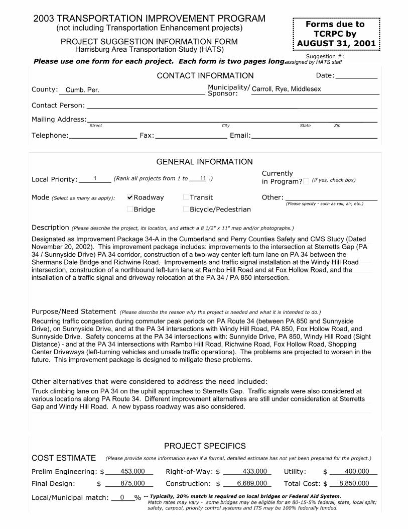
(Rank all projects from 1 to _____ .)
CONTACT INFORMATION
Municipality/ Carroll, Rye, Middlesex
Contact Person:
Mailing Address:
Telephone: Email:
Date:
Local Priority: 1 11
Roadway
Bridge
Transit
Bicycle/Pedestrian
Other:
Prelim Engineering: $ 453,000 Right-of-Way: $ 433,000 Utility: $ 400,000
Final Design: $ 875,000 Construction: $ 6,689,000 Total Cost: $ 8,850,000
Local/Municipal match: 0
PROJECT SUGGESTION INFORMATION FORM
2003 TRANSPORTATION IMPROVEMENT PROGRAM
Harrisburg Area Transportation Study (HATS)
GENERAL INFORMATION
Mode (Select as many as apply):(Please specify - such as rail, air, etc.)
Street City State Zip
(Please describe the project, its location, and attach a 8 1/2" x 11" map and/or photographs.)
(Please describe the reason why the project is needed and what it is intended to do.)
PROJECT SPECIFICS
COST ESTIMATE (Please provide some information even if a formal, detailed estimate has not yet been prepared for the project.)
% -- Typically, 20% match is required on local bridges or Federal Aid System.
Fax:
Please use one form for each project. Each form is two pages long.
Currently in Program? (if yes, check box)
Forms due to
TCRPC by AUGUST 31, 2001
(not including Transportation Enhancement projects)
Cumb. Per.County:
Match rates may vary - some bridges may be eligible for an 80-15-5% federal, state, local split; safety, carpool, priority control systems and ITS may be 100% federally funded.
Suggestion #:
Description
Designated as Improvement Package 34-A in the Cumberland and Perry Counties Safety and CMS Study (Dated November 20, 2002). This improvement package includes: improvements to the intersection at Sterretts Gap (PA 34 / Sunnyside Drive) PA 34 corridor, construction of a two-way center left-turn lane on PA 34 between the Shermans Dale Bridge and Richwine Road, Improvements and traffic signal installation at the Windy Hill Road intersection, construction of a northbound left-turn lane at Rambo Hill Road and at Fox Hollow Road, and the intsallation of a traffic signal and driveway relocation at the PA 34 / PA 850 intersection.
Purpose/Need Statement
Recurring traffic congestion during commuter peak periods on PA Route 34 (between PA 850 and Sunnyside Drive), on Sunnyside Drive, and at the PA 34 intersections with Windy Hill Road, PA 850, Fox Hollow Road, and Sunnyside Drive. Safety concerns at the PA 34 intersections with: Sunnyide Drive, PA 850, Windy Hill Road (Sight Distance) - and at the PA 34 intersections with Rambo Hill Road, Richwine Road, Fox Hollow Road, Shopping Center Driveways (left-turning vehicles and unsafe traffic operations). The problems are projected to worsen in the future. This improvement package is designed to mitigate these problems.
Other alternatives that were considered to address the need included:
Truck climbing lane on PA 34 on the uphill approaches to Sterretts Gap. Traffic signals were also considered at various locations along PA Route 34. Different improvement alternatives are still under consideration at Sterretts Gap and Windy Hill Road. A new bypass roadway was also considered.
Sponsor:
assigned by HATS staff

ROADWAY
BRIDGE
TRANSIT
BICYCLE / PEDESTRIAN
OTHER
Road Name: PA Route 34 / Sunnyside Drive
Traffic Route No.: State Route No.: 0034/1007 Township Route No.:
Limits - From:Sterretts Gap (Sunnyside Drive - SR 1007) To: Rambo Hill Road
Reconstruct
Add lanes
Widen shoulders
Relocate
New RoadOther:
Municipal Participation: Muncipalities will be responsible for maintenance of traffic signals
Bridge Name:BMS No:
Feature Crossed:
Bridge Type: Length: Width: Age:
Vertical Clearance: Weight LimitDetour
Replace Rehabilitate Remove
miles
Improvement Suggestion:(Select as many as apply): Resurface (Please specify)
(curbs, sidewalks, traffic signals, etc.)
(BMS = Bridge Mgmt System)
(steel truss, arch, box, etc.)
(posted):
Improvement Suggestion:
(if yes, check box + note miles)
Location- From: To:
Length:
Ridership EstimateService Generators:
New Service Expanded Service Equipment Facility
Other
Facility:
Nearest Route No.:
Location - From:
To:
Length:
Anticipated No. of Users:
TransportationRecreation
New Path New Lane Connect to existing networkShoulder Improvement
Other
Please provide information below such that proper consideration may be given to the suggested improvement. Attach additional sheets, as necessary.
Improvement Suggestion:
(Please specify):
Congestion Relief Location EfficiencyBasic MobilityGeneral Purpose(Select as many as apply):
miles
miles
Improvement Suggestio
(Please specify):
General Purpose:
(Select as many as apply):
per day
On Federal Aid System?
Year Last Improved:
(check one)
SR Value
mi.
(SR = Sufficiency Rating)
Grade Crossing
(if yes, check box)
Contacts: Diane Myers-Krug, AICP at TCRPC (234-2639); Walt Panko at PennDOT Central (783-2257); or Terry Adams at PennDOT District 8-0 (787-7144).
Please consult the Revised Final Report for the Cumberland and Perry Counties Safety and Congestion Management System Study (dated November 20, 2002) for more information about the proposed improvements. This document was submitted to TCRPC for the Cumberland and Perry Counties Joint Task Force on Transporation and Planning (CPTF).
Dwellings affected by closure?
(if yes, check box + explain on
pg. 1, Purpose/Need Statement)
Length 7.1 Avg Daily Traffic - ADT 17,550 Truck %: 3
(Year built)

(Rank all projects from 1 to _____ .)
CONTACT INFORMATION
Municipality/ Middlesex, Silver Spring
Contact Person:
Mailing Address:
Telephone: Email:
Date:
Local Priority: 2 11
Roadway
Bridge
Transit
Bicycle/Pedestrian
Other:
Prelim Engineering: $ 725,000 Right-of-Way: $ 725,000 Utility: $ 600,000
Final Design: $ 1,450,000 Construction: $ 11,000,000 Total Cost: $ 14,500,000
Local/Municipal match: 0
PROJECT SUGGESTION INFORMATION FORM
2003 TRANSPORTATION IMPROVEMENT PROGRAM
Harrisburg Area Transportation Study (HATS)
GENERAL INFORMATION
Mode (Select as many as apply):(Please specify - such as rail, air, etc.)
Street City State Zip
(Please describe the project, its location, and attach a 8 1/2" x 11" map and/or photographs.)
(Please describe the reason why the project is needed and what it is intended to do.)
PROJECT SPECIFICS
COST ESTIMATE (Please provide some information even if a formal, detailed estimate has not yet been prepared for the project.)
% -- Typically, 20% match is required on local bridges or Federal Aid System.
Fax:
Please use one form for each project. Each form is two pages long.
Currently in Program? (if yes, check box)
Forms due to
TCRPC by AUGUST 31, 2001
(not including Transportation Enhancement projects)
CumberlandCounty:
Match rates may vary - some bridges may be eligible for an 80-15-5% federal, state, local split; safety, carpool, priority control systems and ITS may be 100% federally funded.
Suggestion #:
Description
Designated as Improvement Package 944-A in the Cumberland and Perry Counties Safety and CMS Study (Dated November 20, 2002). This improvement package includes: construction of a center left-turn lane on PA 944 between Sunnyside Drive and the construction of a 2nd northbound left-turn lane at the PA Route 114 intersection.
Purpose/Need Statement
Capacity and safety problems exist and are projected to worsen on PA Route 944 (between Sunnyside Drive and PA 114), and at the intersection of PA 944 / PA 114. This improvement package is designed to mitigate these problems.
Other alternatives that were considered to address the need included:
Reconstruction of PA 944 as a four-lane or five-lane roadway. A new traffic signal is still a possibility at the intersection PA 944 and Sunnyside Drive. A new bypass roadway was also considered.
Sponsor:
assigned by HATS staff

ROADWAY
BRIDGE
TRANSIT
BICYCLE / PEDESTRIAN
OTHER
Road Name: PA Route 944
Traffic Route No.: State Route No.: 0944 Township Route No.:
Limits - From:Sunnyside Drive To: PA Route 114
Reconstruct
Add lanes
Widen shoulders
Relocate
New RoadOther:
Municipal Participation: Muncipalities will be responsible for maintenance of traffic signals
Bridge Name:BMS No:
Feature Crossed:
Bridge Type: Length: Width: Age:
Vertical Clearance: Weight LimitDetour
Replace Rehabilitate Remove
miles
Improvement Suggestion:(Select as many as apply): Resurface (Please specify)
(curbs, sidewalks, traffic signals, etc.)
(BMS = Bridge Mgmt System)
(steel truss, arch, box, etc.)
(posted):
Improvement Suggestion:
(if yes, check box + note miles)
Location- From: To:
Length: 0.00
Ridership Estimate 0Service Generators:
New Service Expanded Service Equipment Facility
Other
Facility:
Nearest Route No.:
Location - From:
To:
Length:
Anticipated No. of Users:
TransportationRecreation
New Path New Lane Connect to existing networkShoulder Improvement
Other
Please provide information below such that proper consideration may be given to the suggested improvement. Attach additional sheets, as necessary.
Improvement Suggestion:
(Please specify):
Congestion Relief Location EfficiencyBasic MobilityGeneral Purpose(Select as many as apply):
miles
miles
Improvement Suggestio
(Please specify):
General Purpose:
(Select as many as apply):
per day
On Federal Aid System?
Year Last Improved:
(check one)
SR Value
0 mi.
(SR = Sufficiency Rating)
Grade Crossing
(if yes, check box)
Contacts: Diane Myers-Krug, AICP at TCRPC (234-2639); Walt Panko at PennDOT Central (783-2257); or Terry Adams at PennDOT District 8-0 (787-7144).
Please consult the Revised Final Report for the Cumberland and Perry Counties Safety and Congestion Management System Study (dated November 20, 2002) for more information about the proposed improvements. This document was submitted to TCRPC for the Cumberland and Perry Counties Joint Task Force on Transporation and Planning (CPTF).
Dwellings affected by closure?
(if yes, check box + explain on
pg. 1, Purpose/Need Statement)
Length 4.1 Avg Daily Traffic - ADT 13,600 Truck %: 3
(Year built)

(Rank all projects from 1 to _____ .)
CONTACT INFORMATION
Municipality/ Penn, Marysville
Contact Person:
Mailing Address:
Telephone: Email:
Date:
Local Priority: 3 11
Roadway
Bridge
Transit
Bicycle/Pedestrian
Other:
Prelim Engineering: $ 508,000 Right-of-Way: $ 561,000 Utility: $ 306,000
Final Design: $ 762,000 Construction: $ 6,500,000 Total Cost: $ 8,637,000
Local/Municipal match:
PROJECT SUGGESTION INFORMATION FORM
2003 TRANSPORTATION IMPROVEMENT PROGRAM
Harrisburg Area Transportation Study (HATS)
GENERAL INFORMATION
Mode (Select as many as apply):(Please specify - such as rail, air, etc.)
Street City State Zip
(Please describe the project, its location, and attach a 8 1/2" x 11" map and/or photographs.)
(Please describe the reason why the project is needed and what it is intended to do.)
PROJECT SPECIFICS
COST ESTIMATE (Please provide some information even if a formal, detailed estimate has not yet been prepared for the project.)
% -- Typically, 20% match is required on local bridges or Federal Aid System.
Fax:
Please use one form for each project. Each form is two pages long.
Currently in Program? (if yes, check box)
Forms due to
TCRPC by AUGUST 31, 2001
(not including Transportation Enhancement projects)
PerryCounty:
Match rates may vary - some bridges may be eligible for an 80-15-5% federal, state, local split; safety, carpool, priority control systems and ITS may be 100% federally funded.
Suggestion #:
Description
Designated as Improvement Package 11-A in the Cumberland and Perry Counties Safety and CMS Study (Dated November 20, 2002). This improvement package includes: installation of a traffic signal at the US 11/15 intersections with Susquenita High School Driveway and PA 850 (and a right-turn lane and a no left-turn sign at PA 850), the installation of an emergency flashing signal at the Perdix Firehouse, construction of NB right-turn lane at Sheetz, pedestrian / bicycle facilities in Perdix and Marysville, parking access road in Marysville, installation of share-a-ride signs and a Park-N-Ride lot, and a route relocation and through truck prohibition study (route re-designation study) for US 11/15 between I-81 and PA 274
Purpose/Need Statement
Capacity and safety problems exist and are projected to worsen on US 11/15 (between I-81 and PA 274), and at certain intersections along US 11/15. There is also an unecessary amount of through truck traffic on US 11/15 - a through traffic bypass (US 22/322) exists on the other side of the Susquehanna River. There are also severe conflicts between pedestrians in Perdix, which have no sidewalks to walk on, and the through traffic on US 11/15. This improvement package is designed to mitigate these problems.
Other alternatives that were considered to address the need included:
Widening of US 11/15 to a three, four, or five-lane roadway. Closing off access from side streets was considered. A new bypass roadway was also considered.
Sponsor:
assigned by HATS staff
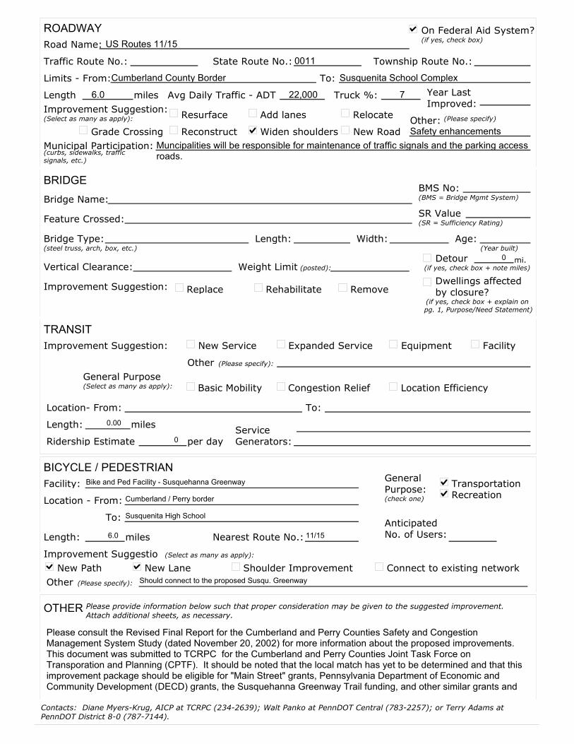
ROADWAY
BRIDGE
TRANSIT
BICYCLE / PEDESTRIAN
OTHER
Road Name: US Routes 11/15
Traffic Route No.: State Route No.: 0011 Township Route No.:
Limits - From:Cumberland County Border To: Susquenita School Complex
Reconstruct
Add lanes
Widen shoulders
Relocate
New RoadOther:Safety enhancements
Municipal Participation: Muncipalities will be responsible for maintenance of traffic signals and the parking access roads.
Bridge Name:BMS No:
Feature Crossed:
Bridge Type: Length: Width: Age:
Vertical Clearance: Weight LimitDetour
Replace Rehabilitate Remove
miles
Improvement Suggestion:(Select as many as apply): Resurface (Please specify)
(curbs, sidewalks, traffic signals, etc.)
(BMS = Bridge Mgmt System)
(steel truss, arch, box, etc.)
(posted):
Improvement Suggestion:
(if yes, check box + note miles)
Location- From: To:
Length: 0.00
Ridership Estimate 0Service Generators:
New Service Expanded Service Equipment Facility
Other
Facility: Bike and Ped Facility - Susquehanna Greenway
Nearest Route No.: 11/15
Location - From: Cumberland / Perry border
To: Susquenita High School
Length: 6.0
Anticipated No. of Users:
TransportationRecreation
New Path New Lane Connect to existing networkShoulder Improvement
Other Should connect to the proposed Susqu. Greenway
Please provide information below such that proper consideration may be given to the suggested improvement. Attach additional sheets, as necessary.
Improvement Suggestion:
(Please specify):
Congestion Relief Location EfficiencyBasic MobilityGeneral Purpose(Select as many as apply):
miles
miles
Improvement Suggestio
(Please specify):
General Purpose:
(Select as many as apply):
per day
On Federal Aid System?
Year Last Improved:
(check one)
SR Value
0 mi.
(SR = Sufficiency Rating)
Grade Crossing
(if yes, check box)
Contacts: Diane Myers-Krug, AICP at TCRPC (234-2639); Walt Panko at PennDOT Central (783-2257); or Terry Adams at PennDOT District 8-0 (787-7144).
Please consult the Revised Final Report for the Cumberland and Perry Counties Safety and Congestion Management System Study (dated November 20, 2002) for more information about the proposed improvements. This document was submitted to TCRPC for the Cumberland and Perry Counties Joint Task Force on Transporation and Planning (CPTF). It should be noted that the local match has yet to be determined and that this improvement package should be eligible for "Main Street" grants, Pennsylvania Department of Economic and Community Development (DECD) grants, the Susquehanna Greenway Trail funding, and other similar grants and
Dwellings affected by closure?
(if yes, check box + explain on
pg. 1, Purpose/Need Statement)
Length 6.0 Avg Daily Traffic - ADT 22,000 Truck %: 7
(Year built)

(Rank all projects from 1 to _____ .)
CONTACT INFORMATION
Municipality/ Penn, Duncannon
Contact Person:
Mailing Address:
Telephone: Email:
Date:
Local Priority: 4 11
Roadway
Bridge
Transit
Bicycle/Pedestrian
Other:
Prelim Engineering: $ 165,000 Right-of-Way: $ 110,000 Utility: $ 231,000
Final Design: $ 335,000 Construction: $ 3,021,000 Total Cost: $ 3,631,000
Local/Municipal match: 0
PROJECT SUGGESTION INFORMATION FORM
2003 TRANSPORTATION IMPROVEMENT PROGRAM
Harrisburg Area Transportation Study (HATS)
GENERAL INFORMATION
Mode (Select as many as apply):(Please specify - such as rail, air, etc.)
Street City State Zip
(Please describe the project, its location, and attach a 8 1/2" x 11" map and/or photographs.)
(Please describe the reason why the project is needed and what it is intended to do.)
PROJECT SPECIFICS
COST ESTIMATE (Please provide some information even if a formal, detailed estimate has not yet been prepared for the project.)
% -- Typically, 20% match is required on local bridges or Federal Aid System.
Fax:
Please use one form for each project. Each form is two pages long.
Currently in Program? (if yes, check box)
Forms due to
TCRPC by AUGUST 31, 2001
(not including Transportation Enhancement projects)
PerryCounty:
Match rates may vary - some bridges may be eligible for an 80-15-5% federal, state, local split; safety, carpool, priority control systems and ITS may be 100% federally funded.
Suggestion #:
Description
Designated as Improvement Package 274-A in the Cumberland and Perry Counties Safety and CMS Study (Dated November 20, 2002). This improvement package includes: widening of the shoulders on PA 274 between Delville Road and US 11/15, intersection improvements at the PA 274 intersection with the US 11/15 SB off-ramp and improvement of the overhead clearance at the US 11/15 overpass (over PA 274).
Purpose/Need Statement
Motorist confusion exists and is projected to worsen at the US 11/15 SB off-ramp intersection with PA 274. A low vertical clearnace height exists under the US 11/15 overpass. Substandard shoulders exist on PA 274 between Dellville Road and US 11/15. This improvement package is designed to mitigate these problems.
Other alternatives that were considered to address the need included:
Modifications to the US 11/15 overpass have been conisdered, instead, re-grading the roadway underneath will likely be a more cost-effective improvement while still achieving the desired results.
Sponsor:
assigned by HATS staff
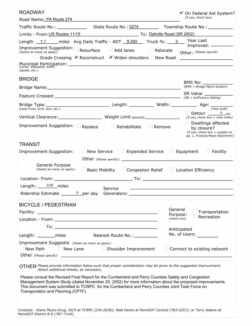
ROADWAY
BRIDGE
TRANSIT
BICYCLE / PEDESTRIAN
OTHER
Road Name: PA Route 274
Traffic Route No.: State Route No.: 0274 Township Route No.:
Limits - From:US Routes 11/15 To: Dellville Road (SR 2002)
Reconstruct
Add lanes
Widen shoulders
Relocate
New RoadOther:
Municipal Participation:
Bridge Name:BMS No:
Feature Crossed:
Bridge Type: Length: Width: Age:
Vertical Clearance: Weight LimitDetour
Replace Rehabilitate Remove
miles
Improvement Suggestion:(Select as many as apply): Resurface (Please specify)
(curbs, sidewalks, traffic signals, etc.)
(BMS = Bridge Mgmt System)
(steel truss, arch, box, etc.)
(posted):
Improvement Suggestion:
(if yes, check box + note miles)
Location- From: To:
Length: 0.00
Ridership Estimate 0Service Generators:
New Service Expanded Service Equipment Facility
Other
Facility:
Nearest Route No.:
Location - From:
To:
Length:
Anticipated No. of Users:
TransportationRecreation
New Path New Lane Connect to existing networkShoulder Improvement
Other
Please provide information below such that proper consideration may be given to the suggested improvement. Attach additional sheets, as necessary.
Improvement Suggestion:
(Please specify):
Congestion Relief Location EfficiencyBasic MobilityGeneral Purpose(Select as many as apply):
miles
miles
Improvement Suggestio
(Please specify):
General Purpose:
(Select as many as apply):
per day
On Federal Aid System?
Year Last Improved:
(check one)
SR Value
0 mi.
(SR = Sufficiency Rating)
Grade Crossing
(if yes, check box)
Contacts: Diane Myers-Krug, AICP at TCRPC (234-2639); Walt Panko at PennDOT Central (783-2257); or Terry Adams at PennDOT District 8-0 (787-7144).
Please consult the Revised Final Report for the Cumberland and Perry Counties Safety and Congestion Management System Study (dated November 20, 2002) for more information about the proposed improvements. This document was submitted to TCRPC for the Cumberland and Perry Counties Joint Task Force on Transporation and Planning (CPTF).
Dwellings affected by closure?
(if yes, check box + explain on
pg. 1, Purpose/Need Statement)
Length 1.1 Avg Daily Traffic - ADT 9,350 Truck %: 3
(Year built)
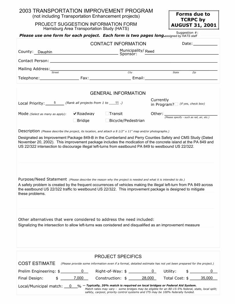
(Rank all projects from 1 to _____ .)
CONTACT INFORMATION
Municipality/ Reed
Contact Person:
Mailing Address:
Telephone: Email:
Date:
Local Priority: 5 11
Roadway
Bridge
Transit
Bicycle/Pedestrian
Other:
Prelim Engineering: $ 0 Right-of-Way: $ 0 Utility: $ 0
Final Design: $ 7,000 Construction: $ 28,000 Total Cost: $ 35,000
Local/Municipal match: 0
PROJECT SUGGESTION INFORMATION FORM
2003 TRANSPORTATION IMPROVEMENT PROGRAM
Harrisburg Area Transportation Study (HATS)
GENERAL INFORMATION
Mode (Select as many as apply):(Please specify - such as rail, air, etc.)
Street City State Zip
(Please describe the project, its location, and attach a 8 1/2" x 11" map and/or photographs.)
(Please describe the reason why the project is needed and what it is intended to do.)
PROJECT SPECIFICS
COST ESTIMATE (Please provide some information even if a formal, detailed estimate has not yet been prepared for the project.)
% -- Typically, 20% match is required on local bridges or Federal Aid System.
Fax:
Please use one form for each project. Each form is two pages long.
Currently in Program? (if yes, check box)
Forms due to
TCRPC by AUGUST 31, 2001
(not including Transportation Enhancement projects)
DauphinCounty:
Match rates may vary - some bridges may be eligible for an 80-15-5% federal, state, local split; safety, carpool, priority control systems and ITS may be 100% federally funded.
Suggestion #:
Description
Designated as Improvement Package 849-B in the Cumberland and Perry Counties Safety and CMS Study (Dated November 20, 2002). This improvement package includes the modication of the concrete island at the PA 849 and US 22/322 intersection to discourage illegal left-turns from eastbound PA 849 to westbound US 22/322.
Purpose/Need Statement
A safety problem is created by the frequent occurrences of vehicles making the illegal left-turn from PA 849 across the eastbound US 22/322 traffic to westbound US 22/322. This improvement package is designed to mitigate these problems.
Other alternatives that were considered to address the need included:
Signalizing the intersection to allow left-turns was conisdered and disqualified as an improvement measure
Sponsor:
assigned by HATS staff

ROADWAY
BRIDGE
TRANSIT
BICYCLE / PEDESTRIAN
OTHER
Road Name: PA Route 849
Traffic Route No.: State Route No.: 0849 Township Route No.:
Limits - From:at its intersection with US 22/322 To: N/A
Reconstruct
Add lanes
Widen shoulders
Relocate
New RoadOther:
Municipal Participation:
Bridge Name:BMS No:
Feature Crossed:
Bridge Type: Length: Width: Age:
Vertical Clearance: Weight LimitDetour
Replace Rehabilitate Remove
miles
Improvement Suggestion:(Select as many as apply): Resurface (Please specify)
(curbs, sidewalks, traffic signals, etc.)
(BMS = Bridge Mgmt System)
(steel truss, arch, box, etc.)
(posted):
Improvement Suggestion:
(if yes, check box + note miles)
Location- From: To:
Length: 0.00
Ridership Estimate 0Service Generators:
New Service Expanded Service Equipment Facility
Other
Facility:
Nearest Route No.:
Location - From:
To:
Length:
Anticipated No. of Users:
TransportationRecreation
New Path New Lane Connect to existing networkShoulder Improvement
Other
Please provide information below such that proper consideration may be given to the suggested improvement. Attach additional sheets, as necessary.
Improvement Suggestion:
(Please specify):
Congestion Relief Location EfficiencyBasic MobilityGeneral Purpose(Select as many as apply):
miles
miles
Improvement Suggestio
(Please specify):
General Purpose:
(Select as many as apply):
per day
On Federal Aid System?
Year Last Improved:
(check one)
SR Value
0 mi.
(SR = Sufficiency Rating)
Grade Crossing
(if yes, check box)
Contacts: Diane Myers-Krug, AICP at TCRPC (234-2639); Walt Panko at PennDOT Central (783-2257); or Terry Adams at PennDOT District 8-0 (787-7144).
Please consult the Revised Final Report for the Cumberland and Perry Counties Safety and Congestion Management System Study (dated November 20, 2002) for more information about the proposed improvements. This document was submitted to TCRPC for the Cumberland and Perry Counties Joint Task Force on Transporation and Planning (CPTF).
Dwellings affected by closure?
(if yes, check box + explain on
pg. 1, Purpose/Need Statement)
Length 0.1 Avg Daily Traffic - ADT 4,850 Truck %: 3
(Year built)

(Rank all projects from 1 to _____ .)
CONTACT INFORMATION
Municipality/ East Pennsboro
Contact Person:
Mailing Address:
Telephone: Email:
Date:
Local Priority: 6 11
Roadway
Bridge
Transit
Bicycle/Pedestrian
Other:
Prelim Engineering: $ 15,000 Right-of-Way: $ 150,000 Utility: $ 55,000
Final Design: $ 30,000 Construction: $ 510,000 Total Cost: $ 760,000
Local/Municipal match: 0
PROJECT SUGGESTION INFORMATION FORM
2003 TRANSPORTATION IMPROVEMENT PROGRAM
Harrisburg Area Transportation Study (HATS)
GENERAL INFORMATION
Mode (Select as many as apply):(Please specify - such as rail, air, etc.)
Street City State Zip
(Please describe the project, its location, and attach a 8 1/2" x 11" map and/or photographs.)
(Please describe the reason why the project is needed and what it is intended to do.)
PROJECT SPECIFICS
COST ESTIMATE (Please provide some information even if a formal, detailed estimate has not yet been prepared for the project.)
% -- Typically, 20% match is required on local bridges or Federal Aid System.
Fax:
Please use one form for each project. Each form is two pages long.
Currently in Program? (if yes, check box)
Forms due to
TCRPC by AUGUST 31, 2001
(not including Transportation Enhancement projects)
CumberlandCounty:
Match rates may vary - some bridges may be eligible for an 80-15-5% federal, state, local split; safety, carpool, priority control systems and ITS may be 100% federally funded.
Suggestion #:
Description
Designated as Improvement Package 944-D in the Cumberland and Perry Counties Safety and CMS Study (Dated November 20, 2002). This improvement package includes: the reconstruction / realignment of the PA Route 944 offset intersection with Magaro Road and Carol Lane into a single, four-leg intersection, and the re-striping of the US 11/15 intersection of PA 944.
Purpose/Need Statement
Capacity and safety problems exist and are projected to worsen at the PA 944 intersection with US 11/15 and at the offset intersection of PA 944 and Magaro Road / Carol Lane. This improvement package is designed to mitigate these problems.
Other alternatives that were considered to address the need included:
Signalizing the intersection to allow vehicles to turn from PA 944 onto US 11/15 southbound, and the construction of a southbound acceleration lane were conisdered and disqualified as improvement measures.
Sponsor:
assigned by HATS staff

ROADWAY
BRIDGE
TRANSIT
BICYCLE / PEDESTRIAN
OTHER
Road Name: PA Route 944
Traffic Route No.: State Route No.: 0944 Township Route No.:
Limits - From:Magaro Road / Carol Lane To: US Routes 11/15
Reconstruct
Add lanes
Widen shoulders
Relocate
New RoadOther:Re-stripe intersection
Municipal Participation: Muncipalities will be responsible for maintenance of traffic signals should signals be warranted in the future
Bridge Name:BMS No:
Feature Crossed:
Bridge Type: Length: Width: Age:
Vertical Clearance: Weight LimitDetour
Replace Rehabilitate Remove
miles
Improvement Suggestion:(Select as many as apply): Resurface (Please specify)
(curbs, sidewalks, traffic signals, etc.)
(BMS = Bridge Mgmt System)
(steel truss, arch, box, etc.)
(posted):
Improvement Suggestion:
(if yes, check box + note miles)
Location- From: To:
Length: 0.00
Ridership Estimate 0Service Generators:
New Service Expanded Service Equipment Facility
Other
Facility:
Nearest Route No.:
Location - From:
To:
Length:
Anticipated No. of Users:
TransportationRecreation
New Path New Lane Connect to existing networkShoulder Improvement
Other
Please provide information below such that proper consideration may be given to the suggested improvement. Attach additional sheets, as necessary.
Improvement Suggestion:
(Please specify):
Congestion Relief Location EfficiencyBasic MobilityGeneral Purpose(Select as many as apply):
miles
miles
Improvement Suggestio
(Please specify):
General Purpose:
(Select as many as apply):
per day
On Federal Aid System?
Year Last Improved:
(check one)
SR Value
0 mi.
(SR = Sufficiency Rating)
Grade Crossing
(if yes, check box)
Contacts: Diane Myers-Krug, AICP at TCRPC (234-2639); Walt Panko at PennDOT Central (783-2257); or Terry Adams at PennDOT District 8-0 (787-7144).
Please consult the Revised Final Report for the Cumberland and Perry Counties Safety and Congestion Management System Study (dated November 20, 2002) for more information about the proposed improvements. This document was submitted to TCRPC for the Cumberland and Perry Counties Joint Task Force on Transporation and Planning (CPTF).
Dwellings affected by closure?
(if yes, check box + explain on
pg. 1, Purpose/Need Statement)
Length 2.3 Avg Daily Traffic - ADT 11,800 Truck %: 4
(Year built)

(Rank all projects from 1 to _____ .)
CONTACT INFORMATION
Municipality/ Penn, Marysville
Contact Person:
Mailing Address:
Telephone: Email:
Date:
Local Priority: 7 11
Roadway
Bridge
Transit
Bicycle/Pedestrian
Other:
Prelim Engineering: $ 25,000 Right-of-Way: $ 14,000 Utility: $ 51,000
Final Design: $ 55,000 Construction: $ 600,000 Total Cost: $ 745,000
Local/Municipal match: 0
PROJECT SUGGESTION INFORMATION FORM
2003 TRANSPORTATION IMPROVEMENT PROGRAM
Harrisburg Area Transportation Study (HATS)
GENERAL INFORMATION
Mode (Select as many as apply):(Please specify - such as rail, air, etc.)
Street City State Zip
(Please describe the project, its location, and attach a 8 1/2" x 11" map and/or photographs.)
(Please describe the reason why the project is needed and what it is intended to do.)
PROJECT SPECIFICS
COST ESTIMATE (Please provide some information even if a formal, detailed estimate has not yet been prepared for the project.)
% -- Typically, 20% match is required on local bridges or Federal Aid System.
Fax:
Please use one form for each project. Each form is two pages long.
Currently in Program? (if yes, check box)
Forms due to
TCRPC by AUGUST 31, 2001
(not including Transportation Enhancement projects)
PerryCounty:
Match rates may vary - some bridges may be eligible for an 80-15-5% federal, state, local split; safety, carpool, priority control systems and ITS may be 100% federally funded.
Suggestion #:
Description
Designated as Improvement Package 11-F in the Cumberland and Perry Counties Safety and CMS Study (Dated November 20, 2002). This improvement package includes: the construction of rock fall protection on US 11/15 at the Cumberland / Perry border and on US 11/15 at Kinkora Heights (between PA 274 and Cove Road).
Purpose/Need Statement
Rocks falling from the mountainsides onto US 11/15 cause severe safety problems. This improvement package is designed to mitigate these safety problems.
Other alternatives that were considered to address the need included:
Sponsor:
assigned by HATS staff

ROADWAY
BRIDGE
TRANSIT
BICYCLE / PEDESTRIAN
OTHER
Road Name: US Routes 11/15
Traffic Route No.: State Route No.: 0011 Township Route No.:
Limits - From:Cumberland / Perry Border To: Kinkora Heights
Reconstruct
Add lanes
Widen shoulders
Relocate
New RoadOther:Install Rock Protection
Municipal Participation:
Bridge Name:BMS No:
Feature Crossed:
Bridge Type: Length: Width: Age:
Vertical Clearance: Weight LimitDetour
Replace Rehabilitate Remove
miles
Improvement Suggestion:(Select as many as apply): Resurface (Please specify)
(curbs, sidewalks, traffic signals, etc.)
(BMS = Bridge Mgmt System)
(steel truss, arch, box, etc.)
(posted):
Improvement Suggestion:
(if yes, check box + note miles)
Location- From: To:
Length: 0.00
Ridership Estimate 0Service Generators:
New Service Expanded Service Equipment Facility
Other
Facility:
Nearest Route No.:
Location - From:
To:
Length:
Anticipated No. of Users:
TransportationRecreation
New Path New Lane Connect to existing networkShoulder Improvement
Other
Please provide information below such that proper consideration may be given to the suggested improvement. Attach additional sheets, as necessary.
Improvement Suggestion:
(Please specify):
Congestion Relief Location EfficiencyBasic MobilityGeneral Purpose(Select as many as apply):
miles
miles
Improvement Suggestio
(Please specify):
General Purpose:
(Select as many as apply):
per day
On Federal Aid System?
Year Last Improved:
(check one)
SR Value
0 mi.
(SR = Sufficiency Rating)
Grade Crossing
(if yes, check box)
Contacts: Diane Myers-Krug, AICP at TCRPC (234-2639); Walt Panko at PennDOT Central (783-2257); or Terry Adams at PennDOT District 8-0 (787-7144).
Please consult the Revised Final Report for the Cumberland and Perry Counties Safety and Congestion Management System Study (dated November 20, 2002) for more information about the proposed improvements. This document was submitted to TCRPC for the Cumberland and Perry Counties Joint Task Force on Transporation and Planning (CPTF).
Dwellings affected by closure?
(if yes, check box + explain on
pg. 1, Purpose/Need Statement)
Length 1.0 Avg Daily Traffic - ADT 22,000 Truck %: 7
(Year built)

(Rank all projects from 1 to _____ .)
CONTACT INFORMATION
Municipality/ Hampden
Contact Person:
Mailing Address:
Telephone: Email:
Date:
Local Priority: 8 11
Roadway
Bridge
Transit
Bicycle/Pedestrian
Other:
Prelim Engineering: $ 12,000 Right-of-Way: $ 80,000 Utility: $ 44,000
Final Design: $ 24,000 Construction: $ 420,000 Total Cost: $ 580,000
Local/Municipal match: 0
PROJECT SUGGESTION INFORMATION FORM
2003 TRANSPORTATION IMPROVEMENT PROGRAM
Harrisburg Area Transportation Study (HATS)
GENERAL INFORMATION
Mode (Select as many as apply):(Please specify - such as rail, air, etc.)
Street City State Zip
(Please describe the project, its location, and attach a 8 1/2" x 11" map and/or photographs.)
(Please describe the reason why the project is needed and what it is intended to do.)
PROJECT SPECIFICS
COST ESTIMATE (Please provide some information even if a formal, detailed estimate has not yet been prepared for the project.)
% -- Typically, 20% match is required on local bridges or Federal Aid System.
Fax:
Please use one form for each project. Each form is two pages long.
Currently in Program? (if yes, check box)
Forms due to
TCRPC by AUGUST 31, 2001
(not including Transportation Enhancement projects)
CumberlandCounty:
Match rates may vary - some bridges may be eligible for an 80-15-5% federal, state, local split; safety, carpool, priority control systems and ITS may be 100% federally funded.
Suggestion #:
Description
Designated as Improvement Package 944-B in the Cumberland and Perry Counties Safety and CMS Study (Dated November 20, 2002). This improvement package includes: the flattening of the crest vertical curve at the intersection of Lambs Gap Road and PA Route 944..
Purpose/Need Statement
Sight distance problems exist at the PA 944 intersection with Lambs Gap Road. This improvement package is designed to mitigate these problems.
Other alternatives that were considered to address the need included:
Sponsor:
assigned by HATS staff
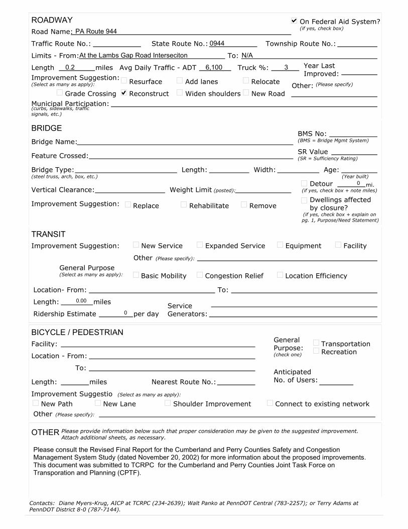
ROADWAY
BRIDGE
TRANSIT
BICYCLE / PEDESTRIAN
OTHER
Road Name: PA Route 944
Traffic Route No.: State Route No.: 0944 Township Route No.:
Limits - From:At the Lambs Gap Road Interseciton To: N/A
Reconstruct
Add lanes
Widen shoulders
Relocate
New RoadOther:
Municipal Participation:
Bridge Name:BMS No:
Feature Crossed:
Bridge Type: Length: Width: Age:
Vertical Clearance: Weight LimitDetour
Replace Rehabilitate Remove
miles
Improvement Suggestion:(Select as many as apply): Resurface (Please specify)
(curbs, sidewalks, traffic signals, etc.)
(BMS = Bridge Mgmt System)
(steel truss, arch, box, etc.)
(posted):
Improvement Suggestion:
(if yes, check box + note miles)
Location- From: To:
Length: 0.00
Ridership Estimate 0Service Generators:
New Service Expanded Service Equipment Facility
Other
Facility:
Nearest Route No.:
Location - From:
To:
Length:
Anticipated No. of Users:
TransportationRecreation
New Path New Lane Connect to existing networkShoulder Improvement
Other
Please provide information below such that proper consideration may be given to the suggested improvement. Attach additional sheets, as necessary.
Improvement Suggestion:
(Please specify):
Congestion Relief Location EfficiencyBasic MobilityGeneral Purpose(Select as many as apply):
miles
miles
Improvement Suggestio
(Please specify):
General Purpose:
(Select as many as apply):
per day
On Federal Aid System?
Year Last Improved:
(check one)
SR Value
0 mi.
(SR = Sufficiency Rating)
Grade Crossing
(if yes, check box)
Contacts: Diane Myers-Krug, AICP at TCRPC (234-2639); Walt Panko at PennDOT Central (783-2257); or Terry Adams at PennDOT District 8-0 (787-7144).
Please consult the Revised Final Report for the Cumberland and Perry Counties Safety and Congestion Management System Study (dated November 20, 2002) for more information about the proposed improvements. This document was submitted to TCRPC for the Cumberland and Perry Counties Joint Task Force on Transporation and Planning (CPTF).
Dwellings affected by closure?
(if yes, check box + explain on
pg. 1, Purpose/Need Statement)
Length 0.2 Avg Daily Traffic - ADT 6,100 Truck %: 3
(Year built)

(Rank all projects from 1 to _____ .)
CONTACT INFORMATION
Municipality/ Reed
Contact Person:
Mailing Address:
Telephone: Email:
Date:
Local Priority: 9 11
Roadway
Bridge
Transit
Bicycle/Pedestrian
Other:
Prelim Engineering: $ 0 Right-of-Way: $ 0 Utility: $ 0
Final Design: $ 18,000 Construction: $ 70,000 Total Cost: $ 88,000
Local/Municipal match: 0
PROJECT SUGGESTION INFORMATION FORM
2003 TRANSPORTATION IMPROVEMENT PROGRAM
Harrisburg Area Transportation Study (HATS)
GENERAL INFORMATION
Mode (Select as many as apply):(Please specify - such as rail, air, etc.)
Street City State Zip
(Please describe the project, its location, and attach a 8 1/2" x 11" map and/or photographs.)
(Please describe the reason why the project is needed and what it is intended to do.)
PROJECT SPECIFICS
COST ESTIMATE (Please provide some information even if a formal, detailed estimate has not yet been prepared for the project.)
% -- Typically, 20% match is required on local bridges or Federal Aid System.
Fax:
Please use one form for each project. Each form is two pages long.
Currently in Program? (if yes, check box)
Forms due to
TCRPC by AUGUST 31, 2001
(not including Transportation Enhancement projects)
DauphinCounty:
Match rates may vary - some bridges may be eligible for an 80-15-5% federal, state, local split; safety, carpool, priority control systems and ITS may be 100% federally funded.
Suggestion #:
Description
Designated as Improvement Package 11-E in the Cumberland and Perry Counties Safety and CMS Study (Dated November 20, 2002). This improvement package includes: the channelization of all eastbound traffic on US 22/322 approaching the US 11/15 interchange into the left lane. This will create a free-merge condition for traffic heading to US 22/322 eastbound from US 11/15 southbound.
Purpose/Need Statement
Safety problems exist with the conflicts in traffic that occur on US 22/322 eastbound at US 11/15 between traffic that is heading to US 22/322 eastbound from US 11/15 southbound and the traffic that is on US 22/322 eastbound. This improvement package is designed to mitigate this problem.
Other alternatives that were considered to address the need included:
The lengthing of the acceleration lanes have been conisdered, instead, the recommended improvement will likely be a more cost-effective improvement while still achieving the desired results.
Sponsor:
assigned by HATS staff
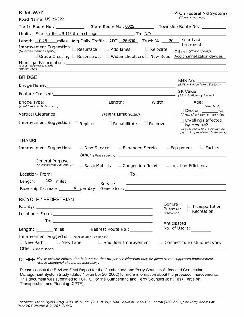
ROADWAY
BRIDGE
TRANSIT
BICYCLE / PEDESTRIAN
OTHER
Road Name: US 22/322
Traffic Route No.: State Route No.: 0022 Township Route No.:
Limits - From:at the US 11/15 interchange To: N/A
Reconstruct
Add lanes
Widen shoulders
Relocate
New RoadOther:Add channelization devices
Municipal Participation:
Bridge Name:BMS No:
Feature Crossed:
Bridge Type: Length: Width: Age:
Vertical Clearance: Weight LimitDetour
Replace Rehabilitate Remove
miles
Improvement Suggestion:(Select as many as apply): Resurface (Please specify)
(curbs, sidewalks, traffic signals, etc.)
(BMS = Bridge Mgmt System)
(steel truss, arch, box, etc.)
(posted):
Improvement Suggestion:
(if yes, check box + note miles)
Location- From: To:
Length: 0.00
Ridership Estimate 0Service Generators:
New Service Expanded Service Equipment Facility
Other
Facility:
Nearest Route No.:
Location - From:
To:
Length:
Anticipated No. of Users:
TransportationRecreation
New Path New Lane Connect to existing networkShoulder Improvement
Other
Please provide information below such that proper consideration may be given to the suggested improvement. Attach additional sheets, as necessary.
Improvement Suggestion:
(Please specify):
Congestion Relief Location EfficiencyBasic MobilityGeneral Purpose(Select as many as apply):
miles
miles
Improvement Suggestio
(Please specify):
General Purpose:
(Select as many as apply):
per day
On Federal Aid System?
Year Last Improved:
(check one)
SR Value
0 mi.
(SR = Sufficiency Rating)
Grade Crossing
(if yes, check box)
Contacts: Diane Myers-Krug, AICP at TCRPC (234-2639); Walt Panko at PennDOT Central (783-2257); or Terry Adams at PennDOT District 8-0 (787-7144).
Please consult the Revised Final Report for the Cumberland and Perry Counties Safety and Congestion Management System Study (dated November 20, 2002) for more information about the proposed improvements. This document was submitted to TCRPC for the Cumberland and Perry Counties Joint Task Force on Transporation and Planning (CPTF).
Dwellings affected by closure?
(if yes, check box + explain on
pg. 1, Purpose/Need Statement)
Length 0.25 Avg Daily Traffic - ADT 35,600 Truck %: 20
(Year built)

(Rank all projects from 1 to _____ .)
CONTACT INFORMATION
Municipality/ Carroll, Centre, Wheatfield, N. Bloomfield
Contact Person:
Mailing Address:
Telephone: Email:
Date:
Local Priority: 10 11
Roadway
Bridge
Transit
Bicycle/Pedestrian
Other:
Prelim Engineering: $ 46,000 Right-of-Way: $ 45,000 Utility: $ 27,000
Final Design: $ 94,000 Construction: $ 700,000 Total Cost: $ 912,000
Local/Municipal match: 0
PROJECT SUGGESTION INFORMATION FORM
2003 TRANSPORTATION IMPROVEMENT PROGRAM
Harrisburg Area Transportation Study (HATS)
GENERAL INFORMATION
Mode (Select as many as apply):(Please specify - such as rail, air, etc.)
Street City State Zip
(Please describe the project, its location, and attach a 8 1/2" x 11" map and/or photographs.)
(Please describe the reason why the project is needed and what it is intended to do.)
PROJECT SPECIFICS
COST ESTIMATE (Please provide some information even if a formal, detailed estimate has not yet been prepared for the project.)
% -- Typically, 20% match is required on local bridges or Federal Aid System.
Fax:
Please use one form for each project. Each form is two pages long.
Currently in Program? (if yes, check box)
Forms due to
TCRPC by AUGUST 31, 2001
(not including Transportation Enhancement projects)
PerryCounty:
Match rates may vary - some bridges may be eligible for an 80-15-5% federal, state, local split; safety, carpool, priority control systems and ITS may be 100% federally funded.
Suggestion #:
Description
Designated as Improvement Package 34-C in the Cumberland and Perry Counties Safety and CMS Study (Dated November 20, 2002). This improvement package includes: the re-striping of the southern Mecks Corner intersection (PA 34, SR 2006, SR 2002), flattening the crest vertical curve at the eastern Mecks Corner intersection (SR 2006, PA 274), and the re-alignment of the PA 34 intersection with Barnett Road..
Purpose/Need Statement
Sight distance problems exist on PA 34 at Barnett Road and at the eastern Mecks Corner intersection. The lack of pavement markings at the western Mecks Corner intersection cause motorist confusion. This improvement package is designed to mitigate these problems.
Other alternatives that were considered to address the need included:
Re-construction and re-alignment of the Mecks Corner intresection have been conisdered, instead, the recommended improvement will likely be a more cost-effective improvement while still achieving the desired results.
Sponsor:
assigned by HATS staff
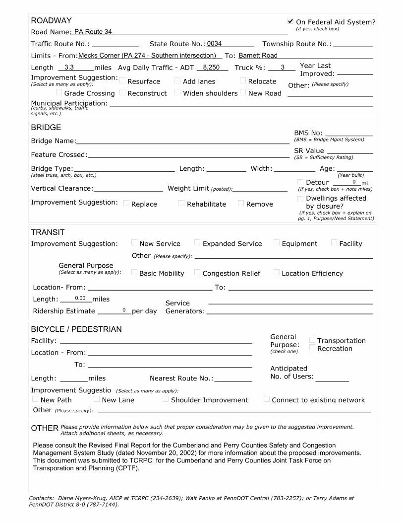
ROADWAY
BRIDGE
TRANSIT
BICYCLE / PEDESTRIAN
OTHER
Road Name: PA Route 34
Traffic Route No.: State Route No.: 0034 Township Route No.:
Limits - From:Mecks Corner (PA 274 - Southern intersection) To: Barnett Road
Reconstruct
Add lanes
Widen shoulders
Relocate
New RoadOther:
Municipal Participation:
Bridge Name:BMS No:
Feature Crossed:
Bridge Type: Length: Width: Age:
Vertical Clearance: Weight LimitDetour
Replace Rehabilitate Remove
miles
Improvement Suggestion:(Select as many as apply): Resurface (Please specify)
(curbs, sidewalks, traffic signals, etc.)
(BMS = Bridge Mgmt System)
(steel truss, arch, box, etc.)
(posted):
Improvement Suggestion:
(if yes, check box + note miles)
Location- From: To:
Length: 0.00
Ridership Estimate 0Service Generators:
New Service Expanded Service Equipment Facility
Other
Facility:
Nearest Route No.:
Location - From:
To:
Length:
Anticipated No. of Users:
TransportationRecreation
New Path New Lane Connect to existing networkShoulder Improvement
Other
Please provide information below such that proper consideration may be given to the suggested improvement. Attach additional sheets, as necessary.
Improvement Suggestion:
(Please specify):
Congestion Relief Location EfficiencyBasic MobilityGeneral Purpose(Select as many as apply):
miles
miles
Improvement Suggestio
(Please specify):
General Purpose:
(Select as many as apply):
per day
On Federal Aid System?
Year Last Improved:
(check one)
SR Value
0 mi.
(SR = Sufficiency Rating)
Grade Crossing
(if yes, check box)
Contacts: Diane Myers-Krug, AICP at TCRPC (234-2639); Walt Panko at PennDOT Central (783-2257); or Terry Adams at PennDOT District 8-0 (787-7144).
Please consult the Revised Final Report for the Cumberland and Perry Counties Safety and Congestion Management System Study (dated November 20, 2002) for more information about the proposed improvements. This document was submitted to TCRPC for the Cumberland and Perry Counties Joint Task Force on Transporation and Planning (CPTF).
Dwellings affected by closure?
(if yes, check box + explain on
pg. 1, Purpose/Need Statement)
Length 3.3 Avg Daily Traffic - ADT 8,250 Truck %: 3
(Year built)

(Rank all projects from 1 to _____ .)
CONTACT INFORMATION
Municipality/ Howe
Contact Person:
Mailing Address:
Telephone: Email:
Date:
Local Priority: 11 11
Roadway
Bridge
Transit
Bicycle/Pedestrian
Other:
Prelim Engineering: $ 12,000 Right-of-Way: $ 2,000 Utility: $ 19,000
Final Design: $ 24,000 Construction: $ 180,000 Total Cost: $ 237,000
Local/Municipal match: 0
PROJECT SUGGESTION INFORMATION FORM
2003 TRANSPORTATION IMPROVEMENT PROGRAM
Harrisburg Area Transportation Study (HATS)
GENERAL INFORMATION
Mode (Select as many as apply):(Please specify - such as rail, air, etc.)
Street City State Zip
(Please describe the project, its location, and attach a 8 1/2" x 11" map and/or photographs.)
(Please describe the reason why the project is needed and what it is intended to do.)
PROJECT SPECIFICS
COST ESTIMATE (Please provide some information even if a formal, detailed estimate has not yet been prepared for the project.)
% -- Typically, 20% match is required on local bridges or Federal Aid System.
Fax:
Please use one form for each project. Each form is two pages long.
Currently in Program? (if yes, check box)
Forms due to
TCRPC by AUGUST 31, 2001
(not including Transportation Enhancement projects)
PerryCounty:
Match rates may vary - some bridges may be eligible for an 80-15-5% federal, state, local split; safety, carpool, priority control systems and ITS may be 100% federally funded.
Suggestion #:
Description
Designated as Improvement Package 34-D in the Cumberland and Perry Counties Safety and CMS Study (Dated November 20, 2002). This improvement package includes: the cutting back of an embankment and the installation of a retaining wall at the PA 34 intersection with Shortcut Road (SR 1017), and sight distance improvements at the PA 34 intersection with the Juniata Parkway (SR 1015).
Purpose/Need Statement
Sight distance problems exist on PA 34 at Shortcut Road and at the Juniata Parkway intersection. This improvement package is designed to mitigate these problems.
Other alternatives that were considered to address the need included:
The installation of rock fall protection was considered at the Shortcut Road intersection.
Sponsor:
assigned by HATS staff

ROADWAY
BRIDGE
TRANSIT
BICYCLE / PEDESTRIAN
OTHER
Road Name: PA Route 34
Traffic Route No.: State Route No.: 0034 Township Route No.:
Limits - From:Juniata Parkway (SR 1015) To: Shortcut Road (SR 1017)
Reconstruct
Add lanes
Widen shoulders
Relocate
New RoadOther:Sight Distance Improvement
Municipal Participation:
Bridge Name:BMS No:
Feature Crossed:
Bridge Type: Length: Width: Age:
Vertical Clearance: Weight LimitDetour
Replace Rehabilitate Remove
miles
Improvement Suggestion:(Select as many as apply): Resurface (Please specify)
(curbs, sidewalks, traffic signals, etc.)
(BMS = Bridge Mgmt System)
(steel truss, arch, box, etc.)
(posted):
Improvement Suggestion:
(if yes, check box + note miles)
Location- From: To:
Length: 0.00
Ridership Estimate 0Service Generators:
New Service Expanded Service Equipment Facility
Other
Facility:
Nearest Route No.:
Location - From:
To:
Length:
Anticipated No. of Users:
TransportationRecreation
New Path New Lane Connect to existing networkShoulder Improvement
Other
Please provide information below such that proper consideration may be given to the suggested improvement. Attach additional sheets, as necessary.
Improvement Suggestion:
(Please specify):
Congestion Relief Location EfficiencyBasic MobilityGeneral Purpose(Select as many as apply):
miles
miles
Improvement Suggestio
(Please specify):
General Purpose:
(Select as many as apply):
per day
On Federal Aid System?
Year Last Improved:
(check one)
SR Value
0 mi.
(SR = Sufficiency Rating)
Grade Crossing
(if yes, check box)
Contacts: Diane Myers-Krug, AICP at TCRPC (234-2639); Walt Panko at PennDOT Central (783-2257); or Terry Adams at PennDOT District 8-0 (787-7144).
Please consult the Revised Final Report for the Cumberland and Perry Counties Safety and Congestion Management System Study (dated November 20, 2002) for more information about the proposed improvements. This document was submitted to TCRPC for the Cumberland and Perry Counties Joint Task Force on Transporation and Planning (CPTF).
Dwellings affected by closure?
(if yes, check box + explain on
pg. 1, Purpose/Need Statement)
Length 1.2 Avg Daily Traffic - ADT 7,500 Truck %: 5
(Year built)
APPENDIX B –
HATS PROJECT RANKING CRITERIA

1
Project Ranking Criteria 2003 Transportation Program Update
BACKGROUND
The goal of the project ranking criteria is to ensure consistency between the mix of projects and investments of the TIP and the goals and policies implemented through the plans and programs in our region. These criteria are intended to serve as a starting point when evaluating projects, and it is expected that they will evolve over time. Common evaluation criteria also will initiate a documented process to track project progress and keep local municipalities informed of their projects’ status. STRUCTURE Potential transportation projects will be evaluated against each of the 17 criteria, as defined by the HATS Technical Committee below.
Criteria 1 - 9: The first seven are the minimum requirements for our transportation program as defined by
Federal (TEA-21) regulations. Other federal regulations applicable to our region are air quality and social/environmental justice impacts.
Criteria 10 – 14: Regional factors considered include the HATS Regional Transportation Plan, Congestion
Management Plan, Regional Growth Management Plan, funding history and new funds available, and PennDOT’s PennPlan Moves plan.
Criteria 15 – 17: Local priorities are also considered in project evaluation. This includes consistency with
the County’s Comprehensive Plan, local/sponsor priority, and local funding commitment. DESCRIPTION Each criterion is described in more detail (attached). A brief statement describes the purpose of the criteria. Federal regulations are quoted directly from the Federal Register for the seven TEA-21 planning factors; the remaining criteria are more broadly described. General project characteristics for each criterion are then listed to determine whether or not a proposed project meets the objective of the criterion, and subsequently earn points under that criterion. If a project does not fit the purpose or characteristics of the criterion, it earns zero points for that criterion. It is not expected that a project will earn points for every criterion. On the whole, all of the projects will be evaluated consistently across the criterion and each project’s merits relative to other projects being proposed can be illustrated. The number of points assigned for each project is determined by its “impact”. Specific improvements or activities are listed to define “high-impact”, “medium-impact”, or “low-impact” projects, earning 10 points, 5 points or 1 point, respectively. A project earns points according to one impact level only. In some cases, “plus” or “minus” points may be assigned if a project has a particular strength in support of or opposition to a criterion. These plus/minus points are specified in nine of the criterion. The points earned from the criterion are summed to give each project a total “score”, and ranked in numerical order to indicate a preliminary priority order for the proposed projects. The priority order will be further refined based on eligibility and availability of specific funding sources (such as CMAQ, STP, bridge, etc.). Fiscal constraint will continue to influence the timing of projects, as undoubtedly will other unforeseen matters.

2
TEA-21 Planning Factors 1. Support the economic vitality of the metropolitan planning area, especially by enabling
global competitiveness, productivity, and efficiency.
General project characteristics include:
! Improves access to airport or intermodal freight facility (within corridor that provides access to foreign trade zone or urban enterprise zone)
! Leads to redevelopment of brownfields, etc. ! Assists tourism/recreation travel within 5 miles of a facility ! Enhances freight movement (truck percentage served, links to rail/freight yards or
industrial parks) ! Improves mobility to job centers
High Impact Projects – 10 points
! Improves access to existing regional activity centers
! Improves rail or vehicular access to freight distribution facilities or major industrial districts
! On route where (heavy) trucks are more than 20% of average daily traffic
! Transportation demand strategies, programs and incentives such as the Commuter Alternatives Program (CAP)
! Improves access to HIA and Capital City Airport
! Alternative fuel infrastructure at major activity centers
Medium Impact Projects – 5 points
! On route where heavy trucks are between 10% and 20% of average daily traffic
Low Impact Projects – 1 point
! Supports mobility needs of business and industry not in an activity center
! Rehabilitation of existing access facilities
Improvement to distressed municipalities = plus 5 points
Brownfields are abandoned, idled, or under-used industrial and commercial facilities where expansion or redevelopment is complicated by real or perceived environmental contamination.
Because lenders, investors, and developers fear that involvement with these sites may make them liable for cleaning up contamination they did not create, they are more attracted to developing sites in pristine areas, called "greenfields." The result can be blighted areas with many abandoned industrial facilities that create safety and health risks for residents, drive up unemployment, and foster a sense of hopelessness. These areas are called "brownfields." (Source: EPA website - http://www.epa.gov/swerosps/bf/index.html#info).
Distressed municipalities are geographic areas where at least 30 percent of the residents have incomes less than the national poverty level, and the unemployment rate is at least 1.5 times greater than the national average. (Source: 12 CFR 1806.200).
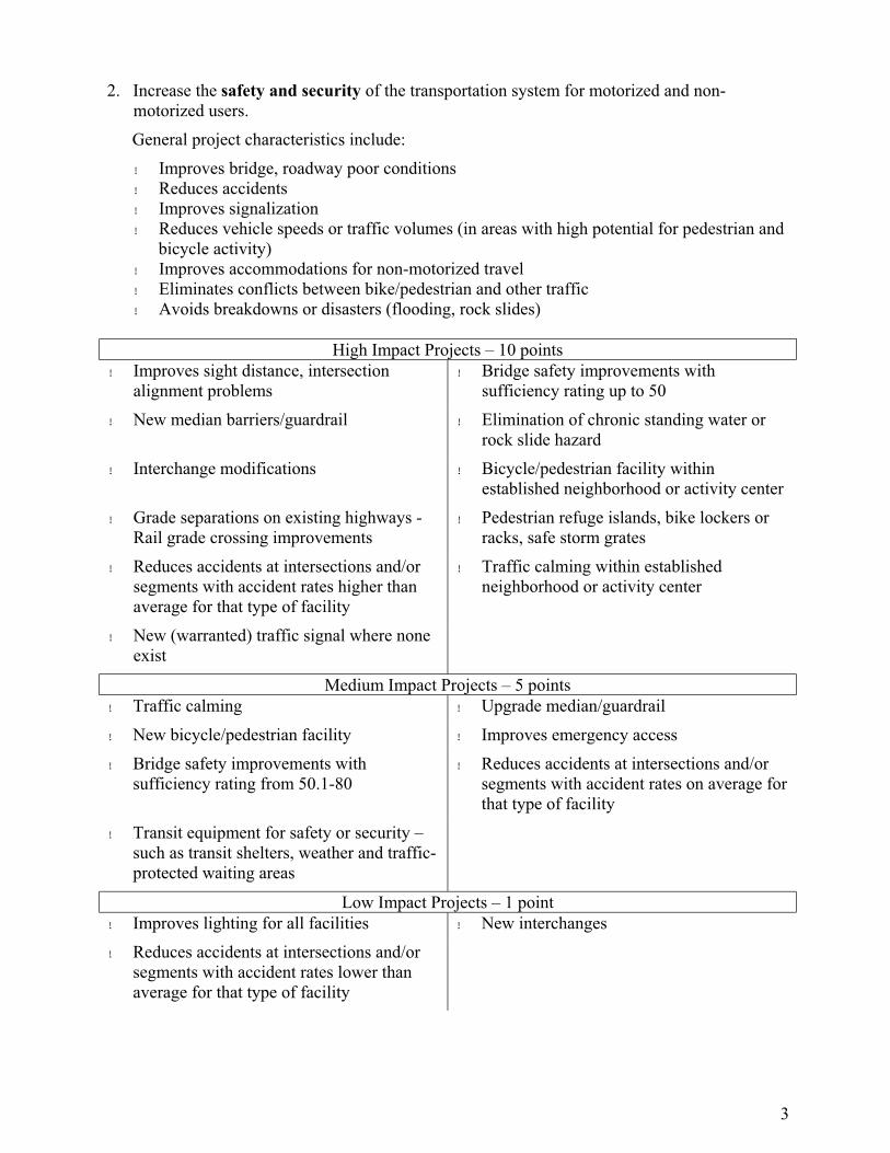
3
2. Increase the safety and security of the transportation system for motorized and non-motorized users.
General project characteristics include:
! Improves bridge, roadway poor conditions ! Reduces accidents ! Improves signalization ! Reduces vehicle speeds or traffic volumes (in areas with high potential for pedestrian and
bicycle activity) ! Improves accommodations for non-motorized travel ! Eliminates conflicts between bike/pedestrian and other traffic ! Avoids breakdowns or disasters (flooding, rock slides)
High Impact Projects – 10 points
! Improves sight distance, intersection alignment problems
! Bridge safety improvements with sufficiency rating up to 50
! New median barriers/guardrail ! Elimination of chronic standing water or rock slide hazard
! Interchange modifications ! Bicycle/pedestrian facility within established neighborhood or activity center
! Grade separations on existing highways - Rail grade crossing improvements
! Pedestrian refuge islands, bike lockers or racks, safe storm grates
! Reduces accidents at intersections and/or segments with accident rates higher than average for that type of facility
! Traffic calming within established neighborhood or activity center
! New (warranted) traffic signal where none exist
Medium Impact Projects – 5 points
! Traffic calming ! Upgrade median/guardrail
! New bicycle/pedestrian facility ! Improves emergency access
! Bridge safety improvements with sufficiency rating from 50.1-80
! Reduces accidents at intersections and/or segments with accident rates on average for that type of facility
! Transit equipment for safety or security – such as transit shelters, weather and traffic-protected waiting areas
Low Impact Projects – 1 point
! Improves lighting for all facilities ! New interchanges
! Reduces accidents at intersections and/or segments with accident rates lower than average for that type of facility

4
3. Increase the accessibility and mobility options available to people and for freight.
General project characteristics include:
! Reduces travel time ! Relieves congestion – Congestion Management System (CMS) strategies (see #11 below) ! Improves information, convenience to users, intermodal linkages ! Optimizes existing capacity ! Increases access to bus, train stations ! Adds frequency and service of bus/transit/rail ! Bicycle and pedestrian facilities
High Impact Projects – 10 points
! New/expanded transit infrastructure – platforms, parking and stations, rail lines
! Access to HIA or Capital City Airport, freight distribution facilities, or major industrial districts
! New transit service, commuter rail, inter-city service
! ITS systems
! Significant expansion (passengers) of existing transit service
! Transportation demand strategies, program, and incentives such as CAP
! Upgrade/computerize signal controllers ! Park and ride lots, and other intermodal linkages
! Bicycle/pedestrian facility serving primarily a transportation use (ie. not recreation)
! On route where heavy trucks are more than 20% of average daily traffic
! Alternative fuel vehicles and infrastructure ! ROW preservation for future transportation corridor
Medium Impact Projects – 5 points
! Upgrade existing transit infrastructure ! Bicycle/pedestrian facility within established neighborhood or activity center
! On route where heavy trucks are between 10% and 20% of average daily traffic
! Functional class - Improvements to rural interstates, rural principal arterials, urban interstates, or urban freeway/expressway
Low Impact Projects – 1 point
! On route where heavy trucks are less than 10% of average daily traffic
! Signing and informational systems (other than ITS)
! Functional class - Improvements to rural minor arterials, rural major collectors, urban principal arterials, or urban minor arterials

5
4. Protect and enhance the environment, promote energy conservation, and improve quality of life.
General project characteristics include:
! Improves air quality (see #8) ! Eliminates vehicle trips – promote bike/pedestrian, transit facilities ! Generates positive effect on water quality (limits impervious surfaces, runoff) ! Abates noise ! Uses recycled materials ! Aesthetics considered in design (context-sensitive design, landscaping, visual easements,
scenic overlooks)
High Impact Projects – 10 points
! Traffic calming within established neighborhood or activity center
! Parking management within established neighborhood or activity center
! Directly promotes shift from single occupancy vehicle (SOV)
! Transportation demand strategies, programs, and incentives (CAP)
! Bus replacement for vehicles beyond useful life (standard transit bus = 12 years or 500,000 miles; vans = 4 years or 100,000 miles)
! Bicycle/pedestrian facilities serving primarily a transportation use
! Clean fuel buses/vehicles - alternative fuel infrastructure
! Creates an improvement in the quantity/quality of water runoff
! Preservation of existing greenway corridors ! Preservation of wetlands
Medium Impact Projects – 5 points
! Traffic calming ! Signal updating and interconnections
! Bicycle/pedestrian facility within established neighborhood or activity center
! Wetlands banking/mitigation
! No significant change in quantity/quality of water runoff
! Intersection channelization resulting in the reduction of stop and go traffic
! Rehab or reconstruction of transit vehicles or facilities that increases ridership
! Preservation of historic structures in national or state register, or of significant local interest
! Parking management ! Park and ride lots
! Enhances efficiency of transit operators
Low Impact Projects – 1 point
! New signal projects ! Performance/condition improvement of transit vehicles or facilities
! Noise barrier projects
Capacity increase for SOV = minus 5 points
Adverse impact on environmentally sensitive areas = minus 5 points
Environmentally sensitive areas as defined in the Regional Growth Management Plan (RGMP): Flood plains, wetlands, stream corridors, Class 1, 2 and 3 prime agricultural soils, steep slopes, and woodlands.

6
5. Enhance the integration and connectivity of the transportation system, across and between modes, for people and freight.
General project characteristics include:
! Supports redevelopment, infill and mixed use development in existing activity centers ! Promotes intermodalism (use of alternate modes - park and ride lots, access to transit/rail,
bike/pedestrian facilities, feeder service, signage) ! Eliminates major barrier in regional corridor; provides gap closure; links jurisdictions and
connects major activity centers ! Provides linkages to other regional systems (Maryland, New York, New Jersey) ! Removes height or weight restrictions
High Impact Projects – 10 points
! Commuter or inter-city rail project ! Park and ride lots
! Corridor preservation project in major regional corridor
! Bicycle/pedestrian facilities making intermodal linkages or regional connections
! Eliminates or overcomes major barrier in an existing regional corridor
! Development of intermodal transportation centers
! Provides gap closure in major regional corridor
Medium Impact Projects – 5 points
! Corridor preservation project in minor regional corridor
! Eliminates or overcomes minor barrier in an existing major regional corridor
! Transportation demand strategies, programs and incentives (CAP)
! Rehabilitation of intermodal transportation centers
! Provides gap closure in minor regional corridor
Low Impact Projects – 1 point
! Eliminates or overcomes barrier in a minor regional corridor
! Provides gap closure in local corridor
Major regional corridors include routes such as I-81, I-83, US 11/15, PA 283, (I-76) – routes which connect our region with other regions. Minor regional corridors include US 22/322, US 22, US 322/422, US 322, US 422, US 11, US 15, US 209, I-283, PA 114, PA 944, PA 581, PA 230, PA 443, PA 225, PA 325, PA 39, PA 34, PA 274, PA 850 – routes providing connectivity within our region. Major barriers include problems such as facility closures, lengthy detours or delays, geography such as rivers and mountains, or rail rights-of-way. Minor barriers include issues such as weight/height restrictions, poor intersection alignments.

7
6. Promote efficient system management and operation.
General project characteristics include:
! Result of or establishes multi-municipal or public-private partnership ! Supports coordination of land use and transportation systems ! Reduces existing/prevent future congestion (improve flow, reduce travel time) ! Reduces SOV trips and promotes transit
High Impact Projects – 10 points
! Increases transit service capacity / reliability
! Relieves congestion on parallel route
! Park and ride lots, vanpools ! ITS improvements
! New or improved intermodal transportation center
! Grade separations on existing highway to improve flow
! Upgrades existing interchanges by improving bicycle/pedestrian access
! Bicycle/pedestrian facility within established neighborhood or activity center
! Signal interconnect of 6 or more signals ! Transportation demand strategies, programs and incentives (CAP)
! Improves roadway at LOS E or F
Medium Impact Projects – 5 points
! Upgrade existing interchanges ! Signal interconnection of 2 to 5 signals
! Introduces new connections between existing street patterns
! New signal which relieves congestion
! Reduces travel time ! Traffic flow improvements
! Intersection improvements ! Median treatments
! Improves roadway at LOS D
Low Impact Projects – 1 point
! Left or center turn lanes ! New interchanges on limited access highway to relieve congestion
! Station/stop amenities and shelters
New non-interconnected signal (lessens efficiency) = minus 5 points

8
7. Emphasize the preservation of the existing transportation system.
General project characteristics include:
! Optimal replacement cycle - delay need for repair/reconstruction (reduces truck vehicle miles traveled (VMT), diverts heavy truck traffic, pavement/resurfacing)
! Facility and fleet replacement or modernization ! Traffic signals and railroad grade crossings improvements
High Impact Projects – 10 points
! Normal pavement or bridge rehabilitation when in pavement or bridge management system
! Existing transit facility replacement/rehab that prolongs useful life of assets (improves “substandard” or “poor” condition ratings)
! Reconstruction or resurfacing of arterial highways
! Traffic signal upgrade
! Transit vehicle replacement/rehab consistent with Federal Transit Administration (FTA) standards (standard transit bus = 12 years or 500,000 miles; vans = 4 years or 100,000 miles)
! Rail warning signals, grade crossings improvement/replacement
! Maintains/preserves publicly owned bicycle and pedestrian facilities
Medium Impact Projects – 5 points
! Normal pavement or bridge rehabilitation when not in pavement or bridge management system
! Existing transit facility replacement/rehab that prolongs useful life of assets (improves “adequate” condition ratings)
! Reconstruction of collector highways ! Roadway and bridge support infrastructure improvements (drainage, retaining, signal)
Low Impact Projects – 1 point
! General resurfacing of roadway

9
Other Fed Regs 8. Air Quality – effects on air quality; US Environmental Protection Agency (EPA) standard
for ozone
General project characteristics include:
! Improve traffic flow, but do not add lanes/capacity or relocate facilities ! Reduce vehicle miles traveled (VMT), discourage single occupancy vehicles (SOV) ! Reduce congestion, or support transit and more compact development
High Impact Projects – 10 points
! New (warranted) traffic signal where none exist, and relieves congestion
! Parking Management
! New or improved transit facilities (stations, buses, park & rides)
! Transportation demand strategies, programs and incentives (CAP)
! New bicycle/pedestrian facility serving primarily a transportation use
Medium Impact Projects – 5 points
! Traffic flow improvements (such as intersection channelization and alignments, signal upgrade/timing/interconnections)
! Bicycle/pedestrian improvements to existing facilities (roadway or bike/ped)
Low Impact Projects – 1 point
! Projects that have no/neutral air quality impact
Increase VMT/congestion = minus 5 points
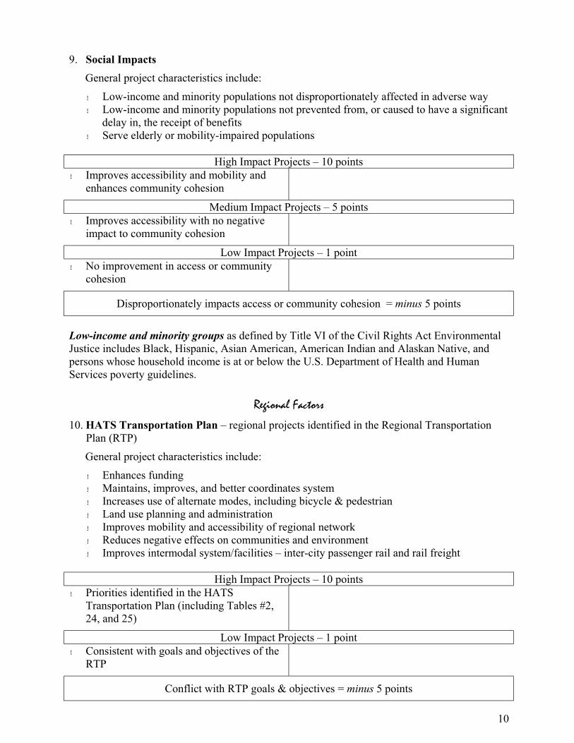
10
9. Social Impacts
General project characteristics include:
! Low-income and minority populations not disproportionately affected in adverse way ! Low-income and minority populations not prevented from, or caused to have a significant
delay in, the receipt of benefits ! Serve elderly or mobility-impaired populations
High Impact Projects – 10 points
! Improves accessibility and mobility and enhances community cohesion
Medium Impact Projects – 5 points
! Improves accessibility with no negative impact to community cohesion
Low Impact Projects – 1 point
! No improvement in access or community cohesion
Disproportionately impacts access or community cohesion = minus 5 points
Low-income and minority groups as defined by Title VI of the Civil Rights Act Environmental Justice includes Black, Hispanic, Asian American, American Indian and Alaskan Native, and persons whose household income is at or below the U.S. Department of Health and Human Services poverty guidelines.
Regional Factors
10. HATS Transportation Plan – regional projects identified in the Regional Transportation Plan (RTP)
General project characteristics include:
! Enhances funding ! Maintains, improves, and better coordinates system ! Increases use of alternate modes, including bicycle & pedestrian ! Land use planning and administration ! Improves mobility and accessibility of regional network ! Reduces negative effects on communities and environment ! Improves intermodal system/facilities – inter-city passenger rail and rail freight
High Impact Projects – 10 points
! Priorities identified in the HATS Transportation Plan (including Tables #2, 24, and 25)
Low Impact Projects – 1 point
! Consistent with goals and objectives of the RTP
Conflict with RTP goals & objectives = minus 5 points

11
11. CMS plan
General project characteristics include:
! Transit, rideshare, park and ride/carpool, non-traditional modes ! Operational improvements (signal timing, etc.) ! Eliminate bottlenecks (physical barriers) ! Freight movement ! Incident management ! Public education/PR ! Land use/growth management ! ITS applications ! Access management ! Employer programs (variable work hours, telecommuting, parking management)
High Impact Projects – 10 points
! High priority areas identified in 1995 CMS study
! “Very practical” strategies identified in 1995 CMS study
Medium Impact Projects – 5 points
! Medium priority areas identified in 1995 CMS study
! “Practical” strategies identified in 1995 CMS study
Low Impact Projects – 1 point
! Low priority areas identified in 1995 CMS study
! Consistent with the goals and objectives of the CMS study

12
12. Regional Growth Management Plan (RGMP) (Not applicable until RGMP officially adopted)
General project characteristics include:
! Development patterns/design that promote pedestrian and non-motorized transportation, reduces auto dependence
! Balanced development - mix of complementary uses ! Compact growth/activity – address planned density (residential, economic, supports
transit) ! Link neighborhoods, connect streets, sidewalks, trails ! Integrate activity areas with surrounding neighborhoods/areas ! Preserve/provide functional open space and natural features ! Intergovernmental cooperation ! Manage supply/effects of parking (congestion, impervious surfaces) ! Retain and attract jobs
High Impact Projects – 10 points
! Located within and support defined “Planned Growth Areas”
! Supports development of regional rail initiatives
Medium Impact Projects – 5 points
! Addresses two or more of the above characteristics
Low Impact Projects – 1 point
! Located outside defined “Planned Growth Areas”
! Consistent with the goals and objectives of the RGMP
In conflict with RGMP goals & objectives = minus 5 points
13. “New” or Previous $ invested
General project characteristics include:
! Projects listed on the previous TIP ! “Reserve” priority project list (derived from RTP and project suggestions not initially
placed on program) funded as federal funds become available – cost savings or new $ ! “New” funds – earmarked for specific projects – does not affect base allocation ! Reimbursement for advance construct projects – estimated line item and potential project
listing provided
High Impact Projects – 10 points
! Listed on the previous TIP ! Listed on “reserve” priority project list (as federal funds become available – cost savings or new $)
Low Impact Projects – 1 point
! Reimbursement for advance construct projects listed on potential project listing
! “Earmarked” with specific funds outside base allocation

13
14. PennPlan Moves!
General project characteristics include:
! Consistency with statewide long range plan
High Impact Projects – 10 points
! Listed on the previous STIP
Medium Impact Projects – 5 points
! Corridor projects within the HATS region: Capitol, Keystone, Blue Mountain, Susquehanna Valley, Cumberland Valley
Low Impact Projects – 1 point
! Corridor projects of state priority outside HATS region which improve accessibility, mobility, or intermodal connectivity of HATS regional network
In conflict with PennPlan = minus 5 points
Local Factors
15. County Priority (Comp Plan) ! Priority ranking assigned by Cumberland, Dauphin and Perry Counties, Fairview
Township in York County, and North Londonderry Township and Palmyra Borough in Lebanon County
! Consistency with local plans
High Impact Projects –10 points
! County Priority #1
Medium Impact Projects –5 points
! County Priority #2
Low Impact Projects –1 point
! County Priority #3
In conflict with local plans = minus 5 points
16. Local/sponsor priority
! Priority ranking assigned by municipality/sponsor
High Impact Projects – 10 points
! Local Priority #1
Medium Impact Projects – 5 points
! Local Priority #2
Low Impact Projects – 1 point
! Local Priority #3
14
17. Local $ Commitment ! Source for local funding/match available
High Impact Projects – 10 points
! Local match above required % (non-federal share)
! Partnership (public/private) projects including multi-municipal efforts