Embed Size (px)
Citation preview

SUMMARY ENVIRONMENTAL IMPACT ASSESSMENT
CHANGCHUN-HARBIN EXPRESSWAY PROJECT
IN THE
THE PEOPLE’S REPUBLIC OF CHINA
July 1998

CURRENCY EQUIVALENTS(as of 20 April 1998)
Currency Unit — Yuan (Y)Y1.00 = $0.1208$1.00 = Y8.3
ABBREVIATIONS
CO — Carbon MonoxideCOD — Chemical Oxygen DemandEA — Executing AgencyEIA — Environmental Impact AssessmentEOC — Edge of CarriagewayGDP — Gross Domestic ProductHPCD — Heilongjiang Provincial Communications DepartmentHHEC — Heilongjiang Hashuang Expressway CorporationHRI — Heilongjiang Scientific Research Institute for
Environmental ProtectionJPCD — Jilin Provincial Communications DepartmentJPEC — Jilin Provincial Expressway CorporationLARP — Land Acquisition and Resettlement PlanMOC — Ministry of CommunicationsNH — National HighwayNNU — Northeast Normal University, ChangchunNOX — Nitrogen OxidesPRC — People’s Republic of ChinaSEIA — Summary Environmental Impact AssessmentSEPA — State Environmental Protection AdministrationSOEs — State-Owned EnterprisesTSP — Total Suspended Particulate
WEIGHTS AND MEASURES
oC — degree CelsiusdB(A) — decibel A (audible decibel)mte — medium truck equivalentmu — land area unit (1 mu = 666m2 ; 15.01 mu = 1 hectare)sec — second
NOTES
In this Report, the symbol ”$” refers to the US dollar.

CONTENTS
Page
MAPS ii
I. INTRODUCTION 1
II. DESCRIPTION OF THE PROJECT 1
III. DESCRIPTION OF THE ENVIRONMENT
A. Physical EnvironmentB. Ecological EnvironmentC. Socioeconomic Environment
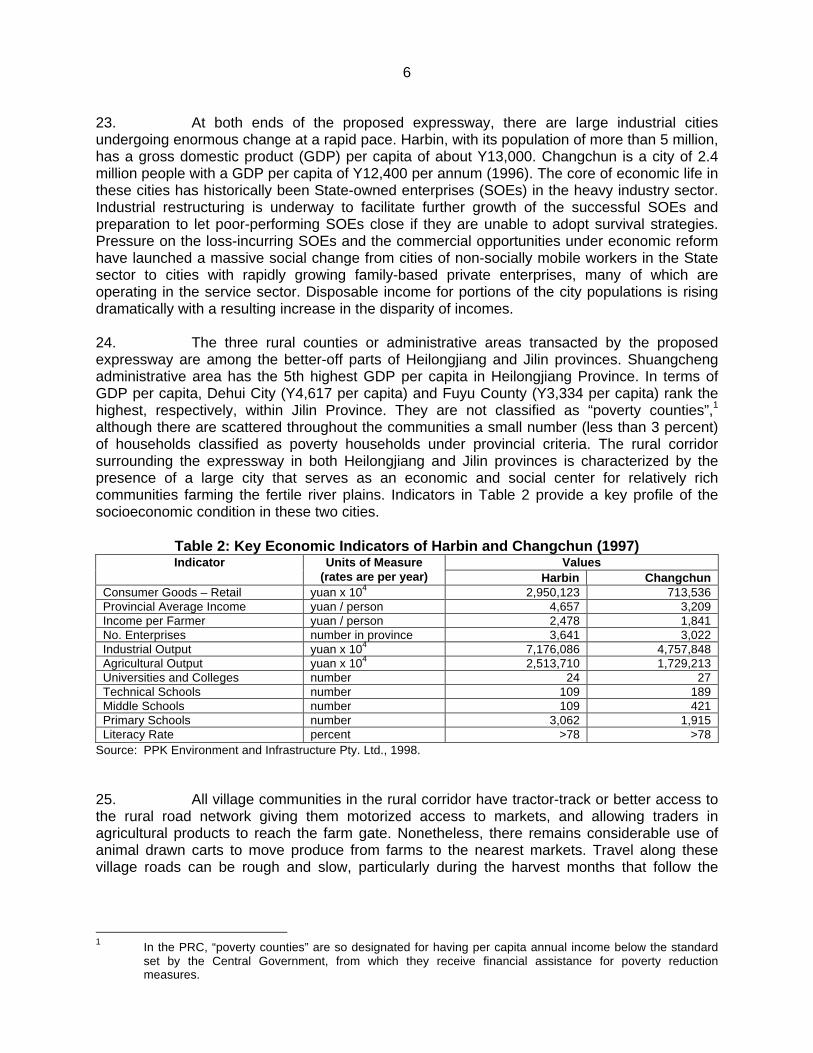
2
256
IV. SOCIOECONOMIC IMPACTS
A. ResettlementB. Air QualityC. NoiseD. Topography, Geology and SoilsE. GroundwaterF. Surface WaterG. Flora and FaunaH. Risk Analysis
8
810111214141617
V. ALTERNATIVES 17
VI. BENEFIT-COST ANALYSIS 18
VII. INSTITUTIONAL ARRANGEMENTS AND ENVIRONMENTAL MONITORING 18
VIII. PUBLIC INVOLVEMENT 19
IX. CONCLUSIONS 19
APPENDIXES 21

I. INTRODUCTION
1. This summary environmental impact assessment (SEIA) has been prepared forthe proposed Changchun-Harbin Expressway Project in the People’s Republic of China (PRC).EIA reports were prepared separately for the Heilongjiang and Jilin Province components by theHeilongjiang Scientific Research Institute for Environmental Protection (HRI) and the NortheastNormal University (NNU) in Changchun, and were approved by the State EnvironmentalProtection Administration (SEPA) on 4 June 1998 and 11 June 1998, respectively. This SEIAcontains the findings and recommendations of both EIAs and is also based on (i) discussionswith the principal authors of the EIA reports, (ii) field visits along both sections of the proposedexpressway, and (iii) discussions with environment sector agencies1 in Changchun and Harbin.
2. The EIA reports were prepared using methodologies consistent with relevantguidelines set out by SEPA and the Ministry of Communications (MOC). This is a widelyaccepted practice in environmental assessment for projects partially funded by internationalfinancial institutions such as the Bank.
II. DESCRIPTION OF THE PROJECT
3. At present, the main roadway linking the southern provinces of the PRC with Jilinand Heilongjiang is the National Highway (NH) 102. Given the broad mix of traffic, varyingvehicle speeds, and many intersections, congestion is high, and delays occur frequently,significantly reducing the efficiency of interprovincial road transportation. The proposed Project,divided into two administrative components, consists of a 263-kilometer (km), four-lane, divided,restricted access toll road, with 14 interchanges and 3 large bridges. The portion throughHeilongjiang will be 102 km including a ring road section around Harbin, and the Jilin portion willbe 161 km including two ring road sections at Changchun. In general, the road will be a raisedalignment from 3.2 to 3.5 meters (m) above grade, with a 28 m wide roadbed at the subgradelevel, a 50 m wide cleared construction area, and a 400 m wide impact zone.2 The estimatedaverage daily traffic volume3 in 2002, the year the section in Heilongjiang Province is scheduledto be opened, will reach 7,300 medium truck equivalents (mtes) per day; for the section in JilinProvince the estimated daily volumes in 2003, the inaugural year, will be 9,500 mtes per day.
4. The current implementation schedule calls for the section in HeilongjiangProvince to be built between 1999 and 2002 and the section in Jilin Province to be constructedbetween 1999 and 2002. The Project cost is estimated at about $929 million equivalent(Heilongjiang: $398 million equivalent, Jilin: $531 million equivalent). It is estimated that 12,500to 15,000 person-years of labor will be required annually for the construction of Heilongjiangand Jilin road sections, respectively. This means that more than 25,000 people could beworking on the Project at any one time. Given this schedule, forecast years for air quality andnoise predictions were established as 2002, 2010, and 2020 for both provinces.
1 Agencies in Heilongjiang and Jilin were the provincial environmental protection bureaus and the provincial
communications departments.
2 Cleared construction area refers to the area 25 m on either side of the alignment centerline; the impactzone refers to the area 200 m on either side of the alignment centerline, where effects of the project areassessed. Water effects extend for 500 m downstream.
3 The average annual daily traffic volume was calculated for medium truck equivalents (mtes), i.e., smalltrucks, rather than cars, given that the former is the major vehicle type using the road.

2
5. The Heilongjiang Hashuang Express Corporation (HHEC), which wasestablished on 23 March 1998 as a limited liability company wholly owned by HeilongjiangProvince through the Heilongjiang Provincial Communications Department (HPCD), will be theExecuting Agency (EA) responsible for both the construction and operation of the Heilongjiangsection of the Project expressway: the Hashuang Expressway.
6. The Jilin Provincial Expressway Corporation (JPEC), a limited liability companywholly owned by Jilin Provincial Communications Department (JPCD), will be the EAresponsible for both the construction and operation of the Chang Lin Expressway: the Jilinsection of the Project expressway. JPEC is headed by a general manager who is also one ofthe vice-directors of JPCD. The construction of the expressway will be organized by JPEC’sconstruction management office, while operation will be undertaken by JPEC’s ExpresswayAdministration Office, which also reports to JPCD. JPEC is already responsible for operationand management of three existing expressways in the province, including the Bank-assistedChangchun-Siping Expressway. Each expressway is operated as a separate profit center withinthe Expressway Administration Office of JPEC.
III. DESCRIPTION OF THE ENVIRONMENT
A. Physical Environment
1. Meteorology
7. Heilongjiang and Jilin provinces have similar climates, with Heilongjiang beingslightly (1-2 degrees Celsius [oC]) cooler all year round, particularly during the fall and spring.Reflecting the conditions of a northern temperate continental climatic zone, the Project area hasup to six months of freezing or below freezing temperatures and snowfall ranging from 16-25centimeters (cm). Other than during the short monsoon summers (June-August), when rainfallis as high as 190 millimeters per month, the area is dry and windy (4-9 m/second) withpredominant weather coming from the south-southwest and southwest. The ground is frozenfrom November through March, to an average depth of 1.8 m. Given these meteorologicalconditions, planning for intensive high-volume storm runoff will be crucial to avoid erosion andrelated problems.
2. Topography, Geology, and Soil
8. The Project area in both provinces passes through the Eastern Songnen(Songliao) Plain, a gently rolling area covered in thick fertile loamy soils, with elevations abovesea level from 150 to 200 m. The proposed expressway corridor has a gently rollingtopography, with slopes of no more than 5 percent, aside from the river valleys, where erosiveforces have carved out steep valley walls (e.g., the south shore of the Lalin River). Largealluvial deposits are scattered throughout the area, reflecting an earlier wetter climate and thefact that the watersheds of three large rivers are found within this area. Soils are 5-33 cm thick,and in the more fertile agricultural areas they are 40-60 cm deep; they are the continuation ofthe fine Loessal Plain material. The high humic content in soils makes them susceptible towater and wind-induced erosion. In both provinces, soil loss has been estimated to be about 8tons/hectare (t/ha), considered acceptable in the region.
9. The area's many low hill formations, nearly all under cultivation, are the primarysource of the road fill material. Under the thick topsoil layer, they contain mud; fine and coarsesand extends from 1-20 m below the surface. The rivers that the proposed expressway will
3
cross have left large alluvial deposits, highly susceptible to erosive forces, such as rain andwind, acting on any exposed and unprotected slopes.
3. Surfacewater
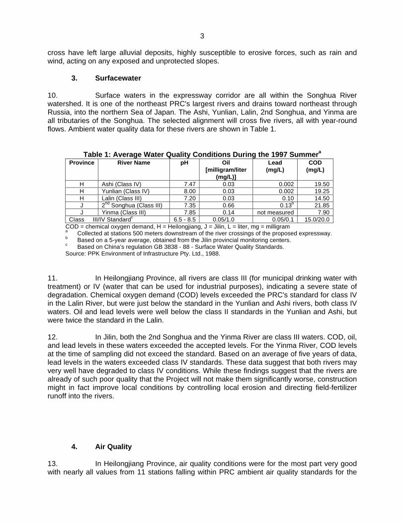
10. Surface waters in the expressway corridor are all within the Songhua Riverwatershed. It is one of the northeast PRC's largest rivers and drains toward northeast throughRussia, into the northern Sea of Japan. The Ashi, Yunlian, Lalin, 2nd Songhua, and Yinma areall tributaries of the Songhua. The selected alignment will cross five rivers, all with year-roundflows. Ambient water quality data for these rivers are shown in Table 1.
Table 1: Average Water Quality Conditions During the 1997 Summera
Province River Name pH Oil[milligram/liter
(mg/L)]
Lead(mg/L)
COD(mg/L)
H Ashi (Class IV) 7.47 0.03 0.002 19.50H Yunlian (Class IV) 8.00 0.03 0.002 19.25H Lalin (Class III) 7.20 0.03 0.10 14.50J 2nd Songhua (Class III) 7.35 0.66 0.13b 21.85J Yinma (Class III) 7.85 0.14 not measured 7.90
CIass III/IV Standardc 6.5 - 8.5 0.05/1.0 0.05/0.1 15.0/20.0COD = chemical oxygen demand, H = Heilongjiang, J = Jilin, L = liter, mg = milligrama Collected at stations 500 meters downstream of the river crossings of the proposed expressway.b Based on a 5-year average, obtained from the Jilin provincial monitoring centers.c Based on China’s regulation GB 3838 - 88 - Surface Water Quality Standards.Source: PPK Environment of Infrastructure Pty. Ltd., 1988.
11. In Heilongjiang Province, all rivers are class III (for municipal drinking water withtreatment) or IV (water that can be used for industrial purposes), indicating a severe state ofdegradation. Chemical oxygen demand (COD) levels exceeded the PRC's standard for class IVin the Lalin River, but were just below the standard in the Yunlian and Ashi rivers, both class IVwaters. Oil and lead levels were well below the class II standards in the Yunlian and Ashi, butwere twice the standard in the Lalin.
12. In Jilin, both the 2nd Songhua and the Yinma River are class III waters. COD, oil,and lead levels in these waters exceeded the accepted levels. For the Yinma River, COD levelsat the time of sampling did not exceed the standard. Based on an average of five years of data,lead levels in the waters exceeded class IV standards. These data suggest that both rivers mayvery well have degraded to class IV conditions. While these findings suggest that the rivers arealready of such poor quality that the Project will not make them significantly worse, constructionmight in fact improve local conditions by controlling local erosion and directing field-fertilizerrunoff into the rivers.
4. Air Quality
13. In Heilongjiang Province, air quality conditions were for the most part very goodwith nearly all values from 11 stations falling within PRC ambient air quality standards for the

4
sampling area.1 Total suspended particulate (TSP) levels were exceeded at four locationsduring the short sampling period. Lead levels exceeded the standard only at Quinlao Tunstation. The overall low contamination levels are reflected in the fact that the area is primarilyrural and open agricultural land, with few roads where mechanized vehicles can travel.
14. In Jilin Province, the stations were evenly distributed along the entire proposedalignment, whereas for Heilongjiang 8 of the 11 stations were located along the Harbin bypassportion of the new alignment. TSP values ranged from 0.168 to 0.396 milligrams/cubic meter(mg/m3) (the ambient air standard is 0.30 mg/m3), with Anlongxingzhun Station’s levelsexceeding these values by almost 30 percent. Lead levels in the air were not measured in JilinProvince, but conditions there are probably similar to Heilongjiang Province, namely: levels 63to 85 percent below the acceptable maximums.
5. Noise
15. Aside from the areas in urban Harbin and Changchun (certain sections aroundthe ring road), the alignment passes through productive farmland planted with corn, sorghum,and some vegetables. Ambient noise is quite low; therefore, expressway noise could be highlyintrusive.
16. In Heilongjiang seven sampling stations, located at sensitive features such asschools and commercial enterprises, were used to monitor noise. Five of these stations werewithin the first 30 km of the road. Daytime noise levels at 30-120 m from the edge of thecarriageway (EOC) at all stations were 40-68 decibel A (dB[A]) in the daytime to 24-55 dB(A) atnight. Only the Sugar Institute station had a dB(A) value minimally exceeding the 60 dB(A)standard for commercial/residential areas. Nonmechanized rural areas normally have the levelof 38-43 dB(A), making the Project area noisy in relative terms, but well below noise levelspermitted in rural residential and farming areas (55 dB[A] during the day and 45 dB[A] at night)that cause human discomfort or health problems.2
17. Along the section in Jilin Province, 34 noise-sensitive sites were identified, andranged from villages within 70 m of the EOC to schools within 100 m of the EOC. It was alsodetermined that more than 27,900 people live and work within the 400 m wide noise impactzone. Six noise-sampling stations were established between km 2 and km 139. Mishazi stationwas located near NH 102 and the Hada railway line crossing, and represented "with traffic"roadside noise conditions. Lowest daytime levels of 29.4 dB(A) were recorded at theZhaoyantun school located 150 m from the right-of-way. Overall average daytime values for theother sites was 45-50 dB(A) and at night ranged from 29 to 34 dB(A), all well within the PRC'slimits for sensitive and residential sites. These data suggest that, with the exception of theMishazi site, noise levels along the proposed alignment are low, or at least within the PRCstandard for rural areas.
B. Ecological Environment
1. Flora and Fauna
18. Both provinces have very high population densities and intensive agriculture;hence, much of the natural flora and fauna for the entire length of the corridor has already been 1 SEPA, 1996. “Ambient Air Quality Standards, GB3095-96”.
2 SEPA, 1993. “Noise Standard for Urban Areas, GB3096-93”.

5
severely altered from wild lands to productive agricultural tracts. There is no sensitive habitatanywhere along the corridor. Common birds in the region are the swallow, magpie, varioussparrows, and the Asian crow.
19. In Heilongjiang Province, aside from the area around the Lalin River bridge, thesection has no sites with sensitive flora or fauna due to the intensive farming in Heilongjiang,and the practice of capturing and eating all wildlife including small songbirds. Few naturalvegetation areas exist in the river floodplain. These have all but been removed throughshoreline sand mining. As in the section in Jilin Province, the wildlife is restricted to a few smallmammals such as rabbits, Mongolian hares and voles, a few reptiles and amphibians(herptiles), and migrating birds that visit the river basins. While none were actually enumerated,local farmers confirmed their presence. It is safe to say that they are all stressed populations.The tree shelterbelts in Heilongjiang abound and form the principal means for the regenerationof the natural ecosystem of the province; as such they must be treated with great sensitivity bythe Project contractors.
20. In Jilin Province, all tree plantations (shelterbelts and roadside plantations)should be protected wherever possible, particularly plantations where the trees are healthy andmature with a life expectancy of another 30-50 years. These plantations will serve as ecologicalregeneration areas providing a habitat for the few birds, mammals, and herptiles remainingand/or passing through the province. Plantations consisting of mostly poplar, larch willow, andKorean pine, plus some understory shrub growth, crisscross the proposed alignment. Each oneis 10-20 m wide and many km long, and during the construction need to be mapped andprotected as much as possible. Aside from these, there are no sensitive features until theSonghua River, where a number of backwater areas may serve as habitat for migrating waterbirds, including the nationally protected swan goose. These areas, are primarily along theupstream shore areas on the northern side of the river, need to be protected from unnecessarydraining or filling. At the Lalin River crossing, similar sites exist and should be protected.
2. Fisheries and Aquatic Biology
21. The rivers crossed by the proposed expressway are generally degraded. Riverbottoms and shorelines are continuously being mined for sand and aggregate materials,preventing the establishment of any sort of benthic or invertebrate fauna. Algae do flourish, dueto the heavy use of artificial fertilizers in this predominantly corn-growing area, which results inhighly enriched runoff (from deforested slopes) into the rivers. Fish habitat has been affected bythe mining operations. The few fish that remain—mostly catfish and minnows—run a constantgauntlet of gill nets, wires, and traps at any location where a remote chance for fish habitatmight exist.
C. Socioeconomic Environment
1. Social Profile of the Area
22. In Heilongjiang Province, the proposed expressway commences at Harbin andpasses through the Shuancheng administrative area (similar to a county). The alignmentcrosses the Lalin River to enter Jilin Province. The alignment then passes through Fuwu Countyand Dehui City and then into Changchun City.
6
23. At both ends of the proposed expressway, there are large industrial citiesundergoing enormous change at a rapid pace. Harbin, with its population of more than 5 million,has a gross domestic product (GDP) per capita of about Y13,000. Changchun is a city of 2.4million people with a GDP per capita of Y12,400 per annum (1996). The core of economic life inthese cities has historically been State-owned enterprises (SOEs) in the heavy industry sector.Industrial restructuring is underway to facilitate further growth of the successful SOEs andpreparation to let poor-performing SOEs close if they are unable to adopt survival strategies.Pressure on the loss-incurring SOEs and the commercial opportunities under economic reformhave launched a massive social change from cities of non-socially mobile workers in the Statesector to cities with rapidly growing family-based private enterprises, many of which areoperating in the service sector. Disposable income for portions of the city populations is risingdramatically with a resulting increase in the disparity of incomes.
24. The three rural counties or administrative areas transacted by the proposedexpressway are among the better-off parts of Heilongjiang and Jilin provinces. Shuangchengadministrative area has the 5th highest GDP per capita in Heilongjiang Province. In terms ofGDP per capita, Dehui City (Y4,617 per capita) and Fuyu County (Y3,334 per capita) rank thehighest, respectively, within Jilin Province. They are not classified as “poverty counties”,1
although there are scattered throughout the communities a small number (less than 3 percent)of households classified as poverty households under provincial criteria. The rural corridorsurrounding the expressway in both Heilongjiang and Jilin provinces is characterized by thepresence of a large city that serves as an economic and social center for relatively richcommunities farming the fertile river plains. Indicators in Table 2 provide a key profile of thesocioeconomic condition in these two cities.
Table 2: Key Economic Indicators of Harbin and Changchun (1997)ValuesIndicator Units of Measure
(rates are per year) Harbin ChangchunConsumer Goods – Retail yuan x 104 2,950,123 713,536Provincial Average Income yuan / person 4,657 3,209Income per Farmer yuan / person 2,478 1,841No. Enterprises number in province 3,641 3,022Industrial Output yuan x 104 7,176,086 4,757,848Agricultural Output yuan x 104 2,513,710 1,729,213Universities and Colleges number 24 27Technical Schools number 109 189Middle Schools number 109 421Primary Schools number 3,062 1,915Literacy Rate percent >78 >78
Source: PPK Environment and Infrastructure Pty. Ltd., 1998.
25. All village communities in the rural corridor have tractor-track or better access tothe rural road network giving them motorized access to markets, and allowing traders inagricultural products to reach the farm gate. Nonetheless, there remains considerable use ofanimal drawn carts to move produce from farms to the nearest markets. Travel along thesevillage roads can be rough and slow, particularly during the harvest months that follow the
1 In the PRC, “poverty counties” are so designated for having per capita annual income below the standard
set by the Central Government, from which they receive financial assistance for poverty reductionmeasures.
7
summer and early autumn rains. There are well over 200 such roads and tracks that intersectthe proposed alignment and could be eliminated as a travel route.1
2. Existing Land Use and Crops
26. The dominant land use for the entire length of the road corridor (encompassingthe alignment and a 400 m wide impact zone totaling 61,417 mu2 of land) is agriculture. This isinterspersed with rural residential and village uses as well as shelterbelt forest plantations. ForHeilongjiang, the breakdown among main land uses is: agriculture (including all cultivated land)74.6 percent, forested (shelterbelt) lands 3.5 percent, land occupied by buildings or villages at15.3 percent, and other uses 6.6 percent. For Jilin (where the impact corridor comprises 84,589mu) the distribution of land use among the three major types is quite similar to Heilongjiang.The breakdown is: agriculture 80.3 percent, forests 4.3 percent, village/residential land 10.6percent, and other uses 4.8 percent. The forest land is not true forest, but rather a plantationforest, regularly harvested and treated as another crop. These impact zones are larger than theactual land taken. In both provinces, borrow areas and their access roads will be sited incultivated but marginal agricultural lands.
27. Cash crops grown in the Harbin-Changchun corridor are corn, rice, soybeans,millet, sugar beets, tobacco, melon, sesame seeds, peanuts, and sunflowers. Fruit includingapples, crab apples, apricots, grapes, pears, pear-apples, and plums provide importantincomes, as does greenhouse gardening where many vegetables such as cucumbers and peasare grown. Corn and rice-growing land is being converted for fruit and vegetable gardening,which yields much greater return.
3. Mineral Resources
28. In Heilongjiang, major mineral resources consist of coal, granite, silica, andpossibly natural gas. The province’s Daqing oil fields, west of Harbin, have a production ratemore than 5,000 x 104 t per year. Jilin’s mineral resources are essentially the same asHeilongjiang’s except for oil. Along the uninhabited river valley shorelines there are also largereserves of peat. Given that most mineral resources are transported by rail, their location andrelative abundance have no bearing on this Project.
4. Gender Issues
29. Both men and women are actively involved in the northeastern farming system,although men undertake more of the mechanized tasks and off-farm employment. This hasresulted in women taking on increasing responsibility for farm production activities, but notnecessarily marketing and management. In this respect, northeastern women are somewhatless represented in local government. However, models of extremely active individuals whohave established successful agribusinesses exist.
1 For this reason farm access underpasses are planned approximately every 640 m along the road, or as
required, based on existing travel patterns between Changchun and Harbin.
2 Land area unit (1 mu = 666m2 ; 15.01 mu = 1 hectare).

8
30. Illiteracy in the economically active population has basically been eradicated inboth provinces, and the Women’s Federation has an active program for extending productiontechnologies and accrediting women as “Ecological Green Card Holders”. Many of theseproduction activities are focused on high-value crops, small livestock and aquaculture, agro-processing, and associated marketing.
IV. SOCIOECONOMIC IMPACTS
A. Resettlement
1. Land Acquisition and Resettlement
31. The Heilongjiang Highway Survey and Design Institute prepared a LandAcquisition and Resettlement Plan (LARP), based on the preliminary technical design.Construction includes 102 km of a four-lane expressway between the provincial capital ofHarbin and the Lalin River, including the Harbin ring road section. Associated works include sixinterchanges, two service areas, two large bridges, and 29 km of link road. The expresswayrequires 678 ha of land permanently and 254 ha of land temporarily. This will affect anestimated 2,250 people along the alignment, mainly in rural areas. Some of these people willalso lose other assets such as houses (150 people in 34 houses) and other structures, youngcrops, and fruit trees. Where there is a significant land loss in their village, some people will betransferred into nonagricultural work. The people affected reside in a number of counties inHarbin and Shuangcheng cities. The agency responsible for the land acquisition andresettlement is the HHEC’s headquarters, which has branches in Harbin and Shuangcheng.
32. The Jilin Highway Survey and Design Institute also prepared a LARP, based onthe preliminary technical design, for its section of the expressway, including: 143 km ofexpressway, eight interchanges, three service areas, and 36 km of link roads. This requires1,209 ha of land permanently and 144 ha of land temporarily for construction purposes. Most ofthis land is agricultural (dry land and rice land). Construction will affect permanently anestimated 4,978 people along the alignment, mainly in rural areas. Some of these people willalso lose other assets such as houses (576 people in 128 houses) and other structures, youngcrops, and fruit trees. An estimated 572 people will be transferred into nonagricultural work ifthere is a significant land loss in their village.
33. Changchun City Highway Planning Survey and Design Institute prepared a LARPfor the expressway links, based on the preliminary technical design. There are two sections:the Ya Zhi Zhang–Feng Jia Tun A link of 5.45 km and the Ya Zhi Zhang–Xing Long San B linkof 12.04 km. They will require 184 ha of land permanently and 8 ha of land temporarily.Permanent land acquisition will affect an estimated 880 people, some 117 of whom will losehousing. Land acquisition and resettlement will be discharged through JPEC.
34. In this Project resettlement will occur within the same area, thus minimizingsocial disruption of neighborhood support networks and familiarity. However, land acquisition insettlements where per capita land holding is already small will result in interim or long-term lossof income unless the value of production can be increased on a per unit basis. This will likelyrequire a shift to higher value crops such as vegetables, mushrooms, and fruits in addition toimproved marketing.
35. The capacity for affected individuals to derive socioeconomic benefits fromresettlement depends on appropriate levels of consultation, timely management, and a just
9
compensation and delivery system. For example, it may be possible for expressway operationauthorities and local communities to agree to joint management, or at least equal opportunity,for participation in expressway activities, such as provision of local construction labor andequipment, work to rehabilitate the borrow sites, and jobs in maintenance and operation of theexpressway and its road-side services.
36. Road construction and operation will restrict the movement of vehicles andpeople within or around settlements through which the road passes (more than 200 suchlinkages will be cut off). To this end, more than 180 underpasses of appropriate dimensionsincluding those for pedestrians will be constructed to allow easy transit for people, vehicles, andagricultural machinery along the whole corridor. The exact location of these underpassesshould be based on thorough discussions and signed agreement with village and/or townshipleaders. In addition, there will be more than 70 overpasses, all accessible to farm traffic.
37. The expressway will split some farmers' fields into parcels on either side of theroad. Locations with farmland reserves will be able to reallocate land within the village, butareas with insufficient spare land will need to readjust the structure of total holdings throughnegotiated exchange of plots among the individual farmers concerned. Again, it will be essentialto increase value-added production activities so as to overcome the income losses resultingfrom the decrease of farmland.
2. Transportation Impacts
38. Many of the outcomes of having an operational expressway will be positive orneutral to the population living along the rural corridor. The facilitation of long-distance trafficand the speed with which perishables can be moved around the country because of theexpressway will increase the demand for agricultural products from farmers and processed andsemiprocessed products from agribusiness. The numbers of traders in the marketing channelswill increase, and the major produce wholesale markets will grow in activity, spawning moreservice industry outlets in the immediate vicinity of the expressway.
B. Air Quality
1. Construction Period
39. Emissions during construction stem from (i) dust caused by aggregatepreparation, concrete mixing, transport of borrow material; (ii) odor emissions from the asphaltplant(s); and (iii) internal combustion engine emissions from truck traffic and heavy equipmentoperation at the construction site and on the roads to and from the borrow areas. Dust plumesfrom aggregate plants, concrete plants, and truck traffic will usually be confined to a radius of400 m from the source. To minimize such environmental impacts, the following remedialmeasures will be taken:
(i) siting of asphalt plants more than 400 m downwind from the nearest settlement;

10
(ii) installation of dust-suppression equipment on the aggregate and concrete plants,and daily watering of construction roads (depending on weather conditions) toconfine the spread of dust to no more than 5 m on either side of the road; and
(iii) proper maintenance of diesel equipment, based on a published maintenanceschedule and curtailment of unnecessary idling.
2. Operational Period
40. For the section in Heilongjiang Province, air quality levels estimated for carbonmonoxide (CO) and nitrogen oxides (NOX) along the expressway were predicted for the years2000, 2010, and 2020 at 11 stations. It is predicted that CO levels will be below the PRCambient air quality standard for distances more than 10 m from the EOC, but that NOX levelswill somewhat exceed the standard along the expressway.
41. In Jilin Province, air emissions were predicted at 34 sensitive sites identified bythe NNU team. CO and NOX were predicted at ten distances (at 10 m intervals) from the EOCfor the years 2002, 2010, and 2020. For the 2020 forecast traffic volumes, CO levels werepredicted to be within the PRC's permitted limits for distances more than 10 m from the EOC.For NOX, it is predicted that daily average level will be within the air quality standard. However,in 2020 NOX level is expected to exceed the standard to some extent along the alignment dueto the increase of traffic volumes.
42. Four mitigative measures can significantly reduce future emissions levels alongthe expressway. The most immediate avoidance measure is to prevent cultivation of certaincrops near the roads. Within 200 m of either side of the road centerline, the land will not beused for leafy crop agriculture but rather for fuel wood, fiber, and plants that will not concentratepollutants to unsafe levels. Plant species to consider could be sunflowers, cotton, and treessuch as mulberry, hazelnut, and walnut. NNU and HRI will be consulted to assist with thedevelopment of planting plans that could be designed to include erection of a visual barrier and,eventually, a wind and noise attenuation structure. A second mitigative measure would be theintroduction of unleaded fuel as soon as possible. The installation of catalytic converters onpetrol-burning vehicles and establishment of a verifiable fleet maintenance program wouldround out the mitigation program. The PRC is now introducing unleaded fuel in Beijing on a testbasis, and shortly in other cities and provinces. With the conversion in fuels will come thecatalytic converters. Fleet maintenance, however, should be required of the large fleet owners.In some provinces, e.g., Liaoning, this has been achieved by emissions monitoring at tollstations.
C. Noise
1. Construction Period
43. Noise impacts during construction can be severe and result from constructionactivities particularly from the operation of heavy machinery. Machinery commonly used in thePRC includes excavators, bulldozers, graders, stabilizers, and rollers. Noise intensity fromthese activities ranges from 80 to 100 dB(A) within 5 m of the source. Noise levels duringconstruction will, during the day, exceed 70 dB(A) at a distance of 50-100 m from the sourceand 55 dB(A) at a distance of 200 m during the night.
44. Special noise generators used during this Project will include pile driving barges,concrete mixing plants, stone crushing and screening plants, and materials storage and

11
warehouses (Noise from the latter two sources generally comes from the moving of materials,heavy equipment, electronic sounds, etc.). There will be literally thousands of truckloads of fillmaterials transported to and from the construction sites. Given the proposed 24-hour workschedule, during the relatively short construction season any roads passing through or nearvillages will experience continuous noise in the 70-80 dB(A) range. Mitigative measuresproposed are as follows:
(i) To reduce night noise, work hours within a 1 km radius of any settlement areawill be restricted to 7:00 to 21:00.
(ii) Special noise generators, such as mobile crushing and mixing facilities, will belocated at least 2 km from the nearest community or service area, e.g.,restaurants, hotels, or tourist sites.
(iii) All construction equipment will have well-maintained muffler systems.
2. Operational Period
45. The noise prediction model specified by the Government was used to forecastnoise levels generated by this Project during the operation period. Two national noisethresholds are used for the assessment of significant noise impacts along the expressway. Forgeneral areas, 70 dB(A) at daytime and 55 dB(A) at night are applied, while 60 dB(A) atdaytime and 50 dB(A) at night for noise-sensitive facilities such as schools and hospitals.
46. In the Heilongjiang EIA, a modeling exercise was conducted in accordance withthe national guideline. It was predicted that by 2010 noise levels of more than 70 dB(A) wouldbe found 30 m from the EOC during the daytime. For the nighttime, by 2020, 60 dB(A) isexpected to be exceeded at 60 m. Only two schools were identified as sensitive facilities, andwould be affected by traffic noise.
47. In Jilin Province, given that much of the noise impact zone is rural farming land(a relatively quiet area), projected nighttime noise levels exceeded recommended levels for allthree prediction years. Within 30 m of the EOC, daytime noise levels were estimated to be 64-69 dB(A); at 120 m values dropped by 4-5 dB(A) in the day and 2-3 dB(A) at night. However, at120 m noise limits were exceeded at a number of the sensitive sites. The 2002 projections forCheziayoufang with population of 300 and Beitaolaizao with population of 250 suggested thatthe limit would be exceeded by 4 dB(A) on average. The 2010 projection indicated that theHeping school, with a student body of 1300, would be 1.4 dB(A) above the permitted level. Forall five representative noise measurements sites (10-150 m from the EOC), the 2020projections indicated serious excess, particularly at night, of 3-8 dB(A). By extrapolating thesefindings to the other 29 sensitive sites, by 2010, 35 percent will have exceeded acceptabledaytime and 85 percent nighttime standards. By 2020, all sites both during the day and nightwill exceed the acceptable standards, with noise levels over the limit by as much as 4-7 dB(A).
48. Based on findings in Heilongjiang and Jilin, the mitigative measure proposed areas follows:
(i) Prevent building of dwellings of any kind from within a 50 m distance from eitherside of the EOC.

12
(ii) Offer families in the noise danger zone the option of either relocating or havingnoise barriers constructed as is being proposed for Heilongjiang. There, 150 mof 3.5 m high barrier walls are proposed at km 4 (school area) from Harbin andat km 19.8 for the year 2010.
(iii) As soon as possible after the construction has stopped, plant a variety of treeand shrub species in a 15 m wide band along the expressway so that by 2010, afully developed tree/shrub barrier is growing.
D. Topography, Geology, and Soils
1. Construction Period
a. Borrow Pits
49. Borrow areas will be established along the entire length of the corridor fromChangchun to Harbin, since much of the road will be elevated 3.2-3.5 m above grade. Giventhe relatively flat terrain in Heilongjiang, an estimated 11.43 million m3 of borrow material1 willneed to be taken from about 25 sites. For Jilin Province, it is estimated that about 9.38 millionm3 of borrow material would be taken from 11 sites. Large cuts are planned in the hilly areasbetween the Lalin and the Yinma rivers, providing large quantities of fill. In terms of land use inthese areas, it is almost all classified as low productivity agricultural, often hilly, terrain. By law,proponents/contractors are not permitted, unless there is no other choice, to use anything butlow productivity or “waste” land, for borrow sites. In terms of land occupied by borrow sites, itwill be 68.8 ha for Jilin and 300 ha for Heilongjiang; the difference is that in Jilin the depth ofexcavation will be 2-4 times deeper than is planned in Heilongjiang.2 Access roads will alsohave to be constructed, whether to rail loading areas or to the construction sites, equaling about150 km for Jilin province and 125 km for Heilongjiang Province. After use, both the borrow siteand the roads will have to be decommissioned. The following mitigative measures for theplanning, operating, and closing of these sites will be implemented:
(i) consult with the community in which the borrow site is to be located six monthsbefore start-up and solicit their advice on best site location, access road location,and topsoil storage site;
(ii) invite the local village to be contracted to rehabilitate the borrow areas in theircommunity;
(iii) extract material in a safe (using benching) and nonpolluting manner, i.e. controldust and noise, at the sites and along the access roads; and
(iv) perform spot checks to confirm that rehabilitation measures such asreapplication of topsoil and crop plantings are carried out as specified under
1 It is assumed that estimates provided in the EIAs were for volumes needed to be disturbed, i.e., including
the topsoil that is not taken from the site. Thus the actual transported volumes would be about 10 percentless than the totals.
2 These estimates do not include access roads that, assuming an average width of 3.5 m and length of 10km, would take up a further 3.5 ha each, of which about 30 percent already exists, leaving 2.45 ha per road,yet to be excavated.

13
PRC mine waste management laws and as agreed to in any contract with thevillage unit(s).
b. Soil Erosion
50. Given that the rich humic soil of both provinces is their major natural resource, itsloss must be prevented. In Heilongjiang, all road sections within the hilly zone of the alignment,i.e. with more than 10-degree gradients (estimated to be about 37 km), are sensitive to erosion;therefore all construction operations need to take proper mitigative steps. Once constructionbegins, the rate of erosion (and soil loss) in the construction zone will increase more than seventimes from the average 8 t/ha/year, but will be confined to the road and borrow areas plus theiraccess routes.
51. For Jilin, a similar situation is likely, except that the area along the alignment thathas more than 10-degree gradient is almost twice the length, and there will be very deep cutsthrough 200-300 m high hills north of the Yinma River.
52. Preventing or minimizing erosion and soil loss is a simple matter of soundconstruction practices, and to that end, the following steps will be carried out by the EA in eachprovince.
(i) Prior to the initiation of any work, the EAs will define on a map the sections of theroad corridor that traverse areas where the gradient is more than 10 degrees andmark this area as erosion sensitive.
(ii) For these areas, including any borrow sites and access roads, a strict plan ofrevegetation and soil stabilization should be prepared, stressing that soilstabilization must be done within 2-4 days after the construction is finished in anysubarea, or when construction ceases for the season. Rehabilitation plansincluding description of plantings and exact type and timing of work should beprepared by the technical departments of the respective EA, and be available forBank audit.
(iii) The task of rehabilitation should be contracted to local villages, with guidanceand monitoring provided by the EAs, and audit functions should be undertakenby the provincial environmental protection bureaus.
2. Operation Period
53. During the operation of the expressways, no significant impacts are predictedother than those resulting from the deterioration of mitigative measures, such as plantings andrevegetation schemes, due to simple neglect. Soil erosion leaving barren areas could also havelong-term negative impacts.
E. Groundwater
54. Groundwater resources should be affected minimally, provided that engineeringdesign teams use the services of a competent hydrogeologist who can identify the near-surfacegroundwater zones. Groundwater, is 5-15 m below the surface. In all areas of deep cuts nearvillages, particularly those located to the west of any cuts, reduction in well water flow ratescould be experienced. The following mitigative measures are proposed:

14
(i) During the detailed design stage, groundwater levels for cuts more than 6 mdeep should be marked. In any areas where the construction activity will likelyinterfere with deep wells, any villages within a 200 m radius of the cut should benotified and provided with compensation such as well upgrading, etc.
(ii) Well water flows in these communities should be monitored for not less than oneyear after the cuts have been made and new or upgraded water suppliesinstalled.
F. Surface Water
1. Construction Period
55. The proposed roadway from Changchun to Harbin will require about 208 watercrossings along the section in Jilin Province and 75 along the section in Heilongjiang Province.There will be 15 medium-sized bridges and 35 small bridges plus over 175 culverts. Thebridges will require diversions, construction equipment in the river beds, and the transport anduse of construction materials in and over the water surface.
56. A workforce amounting to over 18,000 person-years in Jilin and 15,000 inHeilongjiang are expected to work full time on the Project for four years period on the section inJilin Province and for 3.5 years on the section in Heilongjiang Province, and will produce from480,000 to 520,000 liters of sewage per day per province.1
57. Natural drainage of the area will be significantly modified by the road and accessroads that will act as long earthen dams, channeling runoff to the pedestrian underpasses andthe rivers. Wherever possible the drainage (generally from east to west) across the roadway,into the Songhua river) should not be hampered to the point of permanently altering floodingpatterns or background soil moisture levels.
58. To minimize the impacts on surface water, the following measures will be taken:
(i) Bridgework in riverbeds will be confined to the period from mid-August toOctober, the time of year with the lowest flow conditions. The smaller rivers willbe completely dry during this period. In the wet period (June-August), bridgeworkwill be confined to bridge superstructure or abutment work; but if absolutelyessential, dewatering at work sites will be performed.
(ii) All diversions will be planned and executed so as to avoid erosion, and they mustbe removed and the river rehabilitated as quickly as possible after the work iscomplete.
(iii) All toxic, hazardous, and harmful construction materials (caustic and acidicsubstances, petroleum products, heavy metals, etc.) will be handled in such away as to prevent them from entering the water system. They should be storedaway from watercourses and provided with soak pits to contain accidental spills.
1 These figures are based on a per person production rate of 40 liters/day/person (extremely conservative
values in relation to other regions of the world) and a work force of 12,000 - 13,000 people at any one time.

15
(iv) All toilet facilities will be pit toilets that are serviced and maintained, includingremoval and processing of sewage according to a defined schedule. At siteswhere more than 20 people are working continuously, more effective sewagemanagement, such as biogas digesters, should be installed for the production offuel for cooking, heating, and lighting.
(v) Construction area drainage to water bodies will be controlled through thepreparation of settling basin or vegetated runoff areas, allowing thecontaminated water to be slowed or detained, and the sediment and other non-water-soluble components to be filtered out as the water percolates into thesurrounding soils.
(vi) Dredged waste materials and drilling muds must be disposed of on shore, notwithin the river’s high waterline area.
(vii) To maintain adequate surface and subsurface draining, drainage installations(culverts, bridges, and underpasses) should be frequent (minimum every 400 m)and be based on hydrological engineering studies completed as part of theProject.
2. Operation Period
59. Operational period impacts will likely be limited to direct roadway surfacedrainage into watercourses, improper maintenance of erosion protection works, inadequatemanagement of solid and liquid waste for the permanent offices along the expressway,improper sewage management during the construction period, and inadequate accidental spillmanagement. The following mitigative measures are proposed:
(i) Roadway runoff should not be directed into watercourses but allowed to flowover grassed or pervious areas in order to permit the settling out of finematerials, the detention of oily water, and the reduction in volume and rate offlow. This can be achieved through the construction of detentionbasins/depressions, and should be planned as part of the earthworks design.
(ii) Erosion protection works, such as grassed or stabilized slopes, will need regularmaintenance and inspection, particularly during the first year in operation, to besure that the erosion protection measures are functioning (e.g., plants are stillalive and adequately watered).
(iii) Waste and sewage at permanent expressway offices should be managed. Theinstallation of biogas digesters and/or other equally effective treatment systemsas well as solid waste management through a contract with local services forpickup, reuse, and recycling processing is recommended.
G. Flora and Fauna
60. Natural flora and fauna within the two provinces has been reduced over time to afew pockets located far from the road alignment. Nevertheless, there are many shelterbelt treestands that provide pleasing breaks from the expanse of agricultural fields, and have themakings for the reestablishment of natural wildlife and plant communities, provided they are notaggressively harvested. Within the river floodplains, particularly at the Lalin River crossing (lessso at the Songhua River crossing, due to extensive sand mining operations), there are some

16
wetlands allegedly visited by small numbers of migratory waterfowl during the spring and fallmigration periods1. Construction activities should not destroy these wetlands, and constructionworkers should be instructed that no hunting or trapping is to take place in or near them. Mostof the natural fauna, aside from rodents, small mammals, and birds has long ago beeneliminated. Nevertheless, every effort should be made to not accelerate further the steadydecline in available habitat.
61. Since the soils in this area are erodible, stabilization with plant material, as soonas possible after work ceases, will be necessary. The use of fast-growing local grasses, shrubs,hedges, and trees is recommended, in order to build a multilevel habitat. About 16,000 trees(mature, young, and flowering) as well as 25 ha of wooded lands will be lost due to the Projectwithin the construction area 200 m on either side of the expressway. Most of these woods areowned by individuals, who will be compensated according to the LARP.
62. In addition to the compensation described in the LARP, replanting of trees alongthe right-of-way will be increased by at least 3-4 times the number of trees removed, since thesurvival of tree plantings in the wild is at best one in every four. Trees not only provide fiber,fuel, and food but also give shade and act as barriers against noise and erosion. Trees are keyelements in creating natural habitat. An estimated 245,000 trees will need to be planted alongthe expressway section in Heilongjiang Province and another 340,000 in Jilin.
H. Risk Analysis
63. Along the NH 102, hazardous and toxic goods transport involves mainlypetroleum products, explosives, corrosive chemicals, and such items as paint. Generally thelargest quantities are shipped by freight rail. Hazardous and toxic goods transport in Jilin andHeilongjiang provinces, accounts for less than 6 percent of the total traffic flow on NH 102.Accidents occur equally from speeding or reckless driving, and to a lesser extent, fromoverloading and vehicle breakdown. Although records are very difficult to obtain, the generalimpression is that 7-10 accidents involving hazardous materials occur every year on the roadbetween Changchun and Harbin. Of those, probably 1-2 involve unconfined spills and seriouscontamination. Projecting forward to the 2020 traffic volumes, twice the existing number of spillswould be expected. The two key mitigative measures to prevent accidents and to contain spillsare to:
(i) prepare a simple spills contingency plan for the expressway system, defining theactions to be taken in the event of a spill identifying whom to contact, what thechain of command is, and which the clean up procedure to use depending on thetype of spill; and
(ii) provide clear labeling on all shipments, inform/train drivers in proper handling,and base remuneration on the safe delivery of materials rather than on theshortest delivery time.
V. ALTERNATIVES
1 Illegal poachers take a heavy toll on these migrating birds, thus their numbers are extremely low anddeclining. However, this information is not verified.

17
64. For the section in Heilongjiang Province four alignments were examined, and forJilin three alternative routes were examined. As shown in Appendix 1, all possible alignmentswere assessed and compared on the basis of their cost; transportation efficiency; andbiophysical, social, and economic impacts on the community. In terms of impacts on the naturalenvironment, the alternatives within each province were approximately equal, since the area isalmost all corn fields and shelterbelt forest areas, plus a number of water crossings. The majordifference was in terms of resettlement numbers and ha of land required. The alignmentalternative for Heilongjiang was selected because it is expected to meet the functionalrequirements of the expressway section of both provinces, attract traffic in wider areas, andfacilitate economic development of both Harbin and Shuangcheng cities. The alignment wasplanned to avoid cultivated lands and to require elimination of the lowest percentage ofindustrial enterprises. A similar selection process was completed for the Jilin alignments.
VI. BENEFIT-COST ANALYSIS
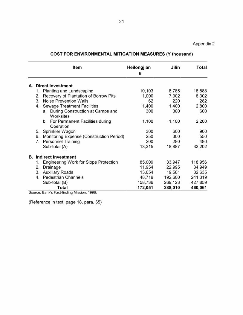
65. The total Project cost is estimated at $929 million equivalent. The costs forenvironmental mitigation measures in both provinces are shown in Appendix 2. The total costfor mitigation measures is Y460 million, and its ratio to the total Project cost is 6.0 percent.
66. The results of the economic analysis show an acceptable economic internal rateof return: 19.5 percent for the Project as a whole, 15.1 percent for Heilongjiang, and 23.0percent for Jilin. The financial internal rate of return is estimated at 5.8 percent for theHeilongjiang section and 8.9 percent for Jilin, respectively, under the condition that the period ofanalysis covers the construction of about four years and 20 years of operation.
VII. INSTITUTIONAL REQUIREMENTS AND ENVIRONMENTAL MONITORING
67. Environmental management for this Project will be carried out at the nationallevel by SEPA and the environmental protection office of MOC. In Heilongjiang, responsibilitieswill be shared by
(i) Environmental Protection Office, HPCD;(ii) Environmental Protection Bureau, Heilongjiang Province;(iii) Environmental Provincial Bureau, Harbin City;(iv) HHEC; and(v) various design institutes, EIA consultants, and contractors.
In Jilin Province, environmental management will be handled by
(i) Environmental Protection Office, JPCD;(ii) Environmental Protection Bureau, Jilin Province;(iii) environmental provincial bureaus of local governments;(iv) JPEC; and(v) various design institutes, EIA consultants, and contractors.
68. The environmental responsibilities of agencies are defined for various stages ofthe Project in Table 3:

18
Table 3: Environmental ResponsibilitiesProject Stage Responsible Agencies/
OrganizationsResponsibilities
Design Design Institute incorporation of mitigation measures into engineering stageDesign HHEC (Heilongjiang)
JPEC (Jilin)review and approval of environmental mitigation and protectionmeasures
Tendering Contractors include environmental management programs in the bidsConstruction Contractors supervise implementation of environmental mitigation and
protection measuresConstruction HHEC (Heilongjiang)
JPEC (Jilin)Environmental monitoring and periodic environmental inspection
Operation HHEC (Heilongjiang)JPEC (Jilin)
Environmental management and environmental monitoring
HHEC = Heilongjiang Hashuang Expressway Corporation, JPEC = Jilin Provincial Expressway CorporationSource: Bank’s Fact-finding Mission, 1998.
69. In Heilongjiang Province, environmental monitoring programs will be conductedby HHEC during both construction and operation stages with support from the Harbin municipalmonitoring center stations. In Jilin Province, environmental monitoring programs will be carriedout by JPEC with support from the provincial monitoring center stations. These monitoringstations have enough staff and experience for environmental monitoring.
70. In-country and out-of-country training programs are proposed for relevantenvironmental staff. Out-of-country training will involve 4 person-months for HeilongjiangProvince and 4 person-months for Jilin Province, respectively.
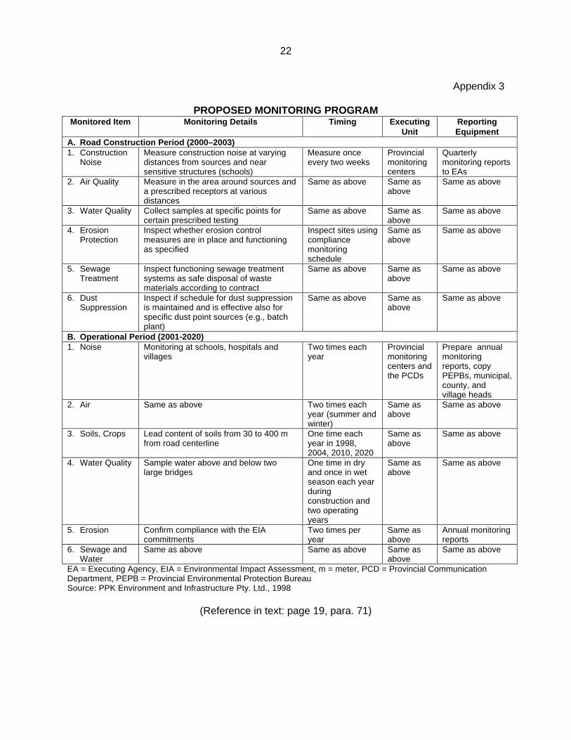
71. The proposed environmental monitoring program is presented in Appendix 3.The environmental monitoring results from construction and operation stages will be submittedto the Environment Office of MOC. HHEC and JPEC will review the monitoring results, and ifnecessary, will decide on further mitigation actions during the construction and operationstages. Copies of all monitoring results will be sent to environmental offices of the counties andcities involved the provincial environmental protection bureaus, and the Bank. Theseagencies/institutions may also recommend environmental mitigation actions.
VIII. PUBLIC INVOLVEMENT
72. Public opinion surveys were conducted from April to May 1997 in Heilongjiangand from June to July 1997 in Jilin. Heilongjiang received 495 responses, and Jilin received 50.The majority of respondents were in favor of the Project and wanted it completed as soon aspossible. The overall interest in the road among farmers was minimal. On most of the otherquestions, the two provinces differed significantly. For example to the question about whatwould be the major impact from the highway on people along that alignment, 57 percent of Jilinrespondents indicated access restrictions. Compared with only 5 percent of those inHeilongjiang, where 80 percent selected noise as the main impact. The survey did not appearto ask any open-ended questions or to look for real input from the local residents, even thoughin the write-up for Heilongjiang, the authors recorded that there were suggestions provided onrevegetation, water course protection, and noise management.
73. The Project is widely publicized by local mass media, particularly in newspaper,in both provinces.

19
IX. CONCLUSIONS
74. Based on the EIAs and other additional reviews, possible negative effects of theproposed expressway between Changchun and Harbin will be minimized and/or reduced to anacceptable level if prescribed mitigative and monitoring actions are carried out. There will besome residual effects, but they will be easily offset by the long-term economic gains for theprovinces and the region. The complete revegetation of the roadway right-of-way, includingmajor tree replanting, will help to stabilize the construction zone soon after the work ceases.The new expressway will reduce congestion on the existing NH 102 and at the same timereduce air pollution, noise, and accidents in the corridor.
75. The entire expressway should have a positive economic impact on the roadcorridor between Changchun and Harbin, providing quicker access to large markets and aconvenient, congestion-free travel route for many. The alignments selected will have the leastnegative impact on both the natural and social environment. Increased noise and air pollutionalong the expressway as traffic volumes build will be offset by appropriate noise attenuationmeasures, vegetation belts, and improvements in engine technology and the introduction ofunleaded fuel.
76. Air and water quality, noise levels, and soil stability will be monitored to ensurethat environmental impacts are within acceptable limits during both construction and operationstages. During construction, water quality will be protected through the use of settling pondsand diversion channels specified in the contract documents. Long-term protection will beprovided through replanting and the use of engineered erosion protection on steeper slopes.

20
Appendix 1
KEY CHARACTERISTICS OF ROAD ALIGNMENT OPTIONSFactors Section in Heilongjiang Province Section in Jilin Provincea
Units I-East II-East(selected)
III-East IV-West East West I West II(selected)
Total Length km 99.16 102.26 102.4 109.2 147.63 146.92 142.94Total Estimated Cost(Engineering)
Y x 106 3,007.24 3,216.67 3,239.82 3,404.79 38,608.2 36,469.1 35,857.9
No. of Villages to beaffected
no. 12 12 12 19 33 26 24
No. of Households tobe Displaced
no. 28 28 28 28 346 124 128
No. of Project AffectedPersons (@5 persons/household)
no. 140 140 140 140 1730 620 640
Water Crossings;Permanent andSeasonal(s)
name - Ashi- Yunliang- Lalin
- Ashi- Yunliang- Lalin
- Ashi- Yunliang- Lalin
- Ashi- Yunliang- Lalin
- 2nd Songhua- Yinma- Mushi
- 2nd Songhua- Yinma
- 2nd Songhua- Yinma
Total Water Crossings(culverts)
no. 73 (60) 75 (62) 75 (62) 83 (65) 258 (191) 212 (72) 208 (164)
Sensitive FeaturesAffected – Name
name almostsame asII-East
1 School almostsame asII-East
12 Villages Songhua R.Cross 6schoolsb
Songhua R.cross 3schools
Songhua R.cross 2schools
Sensitive FeatureRemoved
mb orname
5,500 5,500 5,500 5,500 Schools:E-No.13c
No.24b
Changshanb
Jiminshanb
Schools:Xingshunb
None
Major Interchanges no. 5 6 6 6 7 8 8Major RailwayCrossings – Names
no. 3 3 3 3 1 0 0
Construction WorkForce
person-year/ 4years
person-year/year
48,476
15,139
48,476
15,139
48,476
15,139
48,476
15,139 13,503 12,408
45,417 (3 years)
12,119
Earthworks mc x 106 88.26 89.82 91.95 96.37 212.31 201.82 195.70Land Takend
(temporarily used)mu 10,548.3
(1,544)10,672.6(1,654)
11,089.2(1,546)
11,631.5(1,749)
19,053(2,138)
17,645(2,199)
17,223(2,132)
PedestrianUnderpasses
no. 67 67 67 72 124 112 111
Interchanges no. 5 6 6 6 7 8 8
Overpassesb no. 13 15 15 18 32 54 53Underpassesb no. 23 21 23 26 31 25 24Zone of Influence mixed 426 m corridor width 426 m corridor widthAverage height of fill m 3.2 - 3.5 3.2 - 3.5Width of subgrade m 26 26Note: Project also examined option of rebuilding the existing Beijing-Harbin highway section - with 2nd Class highway (p.
85 of Heilongjiang Feasibility Study).a For Jilin Province, choice of alignment refers to main alignment only.b For details on schools dismantled and needed mitigation measures in Jilin, see Table 6-5 in Feasibility Study.c For details on location and schemes, see Table 5-7-2 of Heilongjiang Feasibility Study.d For details on Jilin, see Table 6-2 in Jilin Feasibility Report, 1997.Source: PPK Environmental Infrastructure Pty. Ltd., 1998.
Appendix 2
2121
Appendix 2
COST FOR ENVIRONMENTAL MITIGATION MEASURES (Y thousand)
Item Heilongjiang
Jilin Total
A. Direct Investment 1. Planting and Landscaping 10,103 8,785 18,888 2. Recovery of Plantation of Borrow Pits 1,000 7,302 8,302 3. Noise Prevention Walls 62 220 282 4. Sewage Treatment Facilities 1,400 1,400 2,800
a. During Construction at Camps andWorksites
300 300 600
b. For Permanent Facilities duringOperation
1,100 1,100 2,200
5. Sprinkler Wagon 300 600 900 6. Monitoring Expense (Construction Period) 250 300 550 7. Personnel Training 200 280 480
Sub-total (A) 13,315 18,887 32,202
B. Indirect Investment 1. Engineering Work for Slope Protection 85,009 33,947 118,956 2. Drainage 11,954 22,995 34,949 3. Auxiliary Roads 13,054 19,581 32,635 4. Pedestrian Channels 48,719 192,600 241,319
Sub-total (B) 158,736 269,123 427,859Total 172,051 288,010 460,061
Source: Bank’s Fact-finding Mission, 1998.
(Reference in text: page 18, para. 65)
22
Appendix 3
PROPOSED MONITORING PROGRAMMonitored Item Monitoring Details Timing Executing
UnitReportingEquipment
A. Road Construction Period (2000–2003)1. Construction
NoiseMeasure construction noise at varyingdistances from sources and nearsensitive structures (schools)
Measure onceevery two weeks
Provincialmonitoringcenters
Quarterlymonitoring reportsto EAs
2. Air Quality Measure in the area around sources anda prescribed receptors at variousdistances
Same as above Same asabove
Same as above
3. Water Quality Collect samples at specific points forcertain prescribed testing
Same as above Same asabove
Same as above
4. ErosionProtection
Inspect whether erosion controlmeasures are in place and functioningas specified
Inspect sites usingcompliancemonitoringschedule
Same asabove
Same as above
5. SewageTreatment
Inspect functioning sewage treatmentsystems as safe disposal of wastematerials according to contract
Same as above Same asabove
Same as above
6. DustSuppression
Inspect if schedule for dust suppressionis maintained and is effective also forspecific dust point sources (e.g., batchplant)
Same as above Same asabove
Same as above
B. Operational Period (2001-2020)1. Noise Monitoring at schools, hospitals and
villagesTwo times eachyear
Provincialmonitoringcenters andthe PCDs
Prepare annualmonitoringreports, copyPEPBs, municipal,county, andvillage heads
2. Air Same as above Two times eachyear (summer andwinter)
Same asabove
Same as above
3. Soils, Crops Lead content of soils from 30 to 400 mfrom road centerline
One time eachyear in 1998,2004, 2010, 2020
Same asabove
Same as above
4. Water Quality Sample water above and below twolarge bridges
One time in dryand once in wetseason each yearduringconstruction andtwo operatingyears
Same asabove
Same as above
5. Erosion Confirm compliance with the EIAcommitments
Two times peryear
Same asabove
Annual monitoringreports
6. Sewage andWater
Same as above Same as above Same asabove
Same as above
EA = Executing Agency, EIA = Environmental Impact Assessment, m = meter, PCD = Provincial CommunicationDepartment, PEPB = Provincial Environmental Protection BureauSource: PPK Environment and Infrastructure Pty. Ltd., 1998
(Reference in text: page 19, para. 71)