Embed Size (px)
Citation preview
Suitability Evaluation of Land Development in Hong Kong New Territory Centre based on GIS
LI Weike1, KE Zilin2 1 Department of Architecture and Civil Engineering, City University of Hong Kong, Hong Kong SAR, P.R. China 2 Faculty of Innovation and Design, City University of Macau, Macau SAR, P.R. China
Email address: [email protected] (LI Weike), [email protected] (KE Zilin)
Abstract: The suitability evaluation of land development is of great significance to measure the potential of land development. Taking Hong Kong New Territory Centre as an example, this paper follows the principles of environmental determinism, integrates physical, biological and cultural attributes in previous evaluation system, reconstructs the land development suitability evaluation model of 11 factors including environmental, social and planning attributes according to the vernacular characteristics of Hong Kong, and assigns weights to each indicator. Using GIS platform, the suitability of land development is analyzed and divided into five grades. What is more, carry on the superposition analysis according to the logical relationship between the three attributes. The results show that: (1) The research area has considerable development potential, more than 30% of the total area. (2) Construction is relatively reasonable and planning capacity is relatively scientific. (3) About 40% of the land is located at thecritical value of environmental attribute, which would have certain ecological risks. Finally, the strategy and advice for the futuredevelopment of the area are proposed based on the above analysis.
Keywords: Suitability evaluation, Environmental determinism, Hong Kong New Territory Centre, Multi-factor weighted evaluation model, GIS
1. IntroductionsHong Kong, owing to its extremely high population
density, has been experiencing one of the most severe conflicts between population and land in the world. At the same time, Hong Kong has extremely high forest coverage and is one of the best places in the world to protect the natural environment. With the issue of Hong Kong 2035+, the city will enter a new period of urban development. The contradiction between the incremental demand for urban development and the strict protection of natural environment will be increasingly notable. As early as 1960s, the research on land suitability evaluation began in foreign countries, involving metropolitan planning, urban green space planning and other research fields. In the 1990s, China also started relevant research on land suitability evaluation, mainly focusing on agricultural land, rural settlements and other fields, but there is a little develop-oriented land suitability evaluation. In order to further analyze the development potential of land in Hong Kong, especially the ecologically sensitive areas, the New Territories Centre (NTC) with good ecological environment in Hong Kong was selected as the research area. The purpose is to take Environment Determinism as the basic concept, on the premise of maximum protection of natural resources and environment, make more reasonable use of limited land, and provide a certain reference for land use planning, and at the same time, enrich the theoretical discussion of land development suitability evaluation.
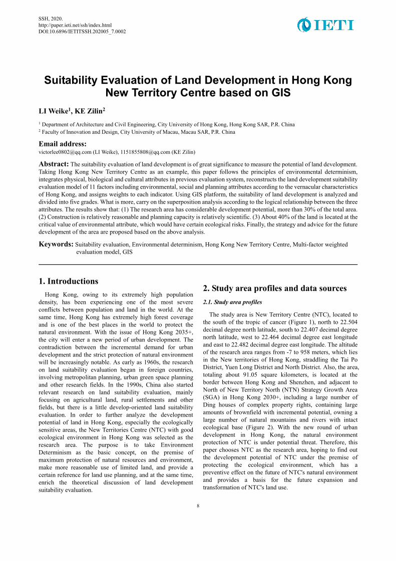
2. Study area profiles and data sources2.1. Study area profiles
The study area is New Territory Centre (NTC), located to the south of the tropic of cancer (Figure 1), north to 22.504 decimal degree north latitude, south to 22.407 decimal degree north latitude, west to 22.464 decimal degree east longitude and east to 22.482 decimal degree east longitude. The altitude of the research area ranges from -7 to 958 meters, which lies in the New territories of Hong Kong, straddling the Tai Po District, Yuen Long District and North District. Also, the area, totaling about 91.05 square kilometers, is located at the border between Hong Kong and Shenzhen, and adjacent to North of New Territory North (NTN) Strategy Growth Area (SGA) in Hong Kong 2030+, including a large number of Ding houses of complex property rights, containing large amounts of brownfield with incremental potential, owning a large number of natural mountains and rivers with intact ecological base (Figure 2). With the new round of urban development in Hong Kong, the natural environment protection of NTC is under potential threat. Therefore, this paper chooses NTC as the research area, hoping to find out the development potential of NTC under the premise of protecting the ecological environment, which has a preventive effect on the future of NTC's natural environment and provides a basis for the future expansion and transformation of NTC's land use.
8
SSH, 2020. http://paper.ieti.net/ssh/index.html DOI:10.6896/IETITSSH.202005_7.0002
Suitability Evaluation of Land Development in Hong Kong New Territory Centre based on GIS
�Figure 1. Location map
�Figure 2. Land use status
Data source: https://www.pland.gov.hk/pland_tc/info_serv/open_data
2.2. Data source, type and processing
The data used for this evaluation are the Digital Terrain Model (DTM) of the study area, the Land Use grid data collected in 2018, and the Point of Interest (POI) data and road network data sets in the study area. The main data sources are the official websites of the Hong Kong Planning Board, the Hong Kong Planning Department, the Hong Kong Lands department and the public open data including the Open Street Map (OSM) and Baidu Map. Before using the data, the author unifies the coordinate system (WGS 1984) for all the data and classifies the point and polyline data according to the functions.
Unless otherwise noted, the figures and tables in this article are made by the author.
3. Construction of evaluation system3.1. Research method and evaluation model
In this paper, a multi-factor weighted evaluation model is used to evaluate the suitability of land development in this research area. Firstly, the factors that may have an impact on the suitability of land development are screened out, deleted and classified. Secondly, by using ArcGIS platform, all kinds of data are quantified and raster distribution map of each factor is generated. Then, assign values to each factor segment by scoring. Then, by using the function of the raster calculator in ArcGIS, each raster layer is superimposed to obtain the comprehensive evaluation result of the suitability of land development. Finally, the results are graded to
determine the spatial distribution of various suitability of land development.
The calculation formula of the multi-factor weighted evaluation model is as follows:
�n: the total number of evaluation indicators, i: the ith evaluation indicators, W: the corresponding weight of evaluation indicators V: the corresponding value of evaluation indicators.
3.2. Land Development Suitability Evaluation
3.2.1. Multi-layer evaluation indicators determination
Previous evaluation systems mainly concerned three influencing attributes, including physical attributes, biological attributes and cultural attributes. However, previous evaluation systems concentrated solely on the existing situation. For medium-scale plots, public infrastructure has been determined in the pre-planning, and this part of the planning to be implemented should not be ignored in the future development of the area. Therefore, the author adds planning attributes on the basis of integrating the former evaluation system.
Land development at medium scale is affected by a combination of nature, society and planning attributes. What is more, such factors as wind direction, temperature and precipitation in the natural environment have limited influence on the suitability of the plot for development due to the medium scale of the plot. Therefore, the factors are removed. Combined with the data collected above and relevant analysis, according to the significant degree of the impact on land development, a total of 11 indicators are determined as the main influencing indicators of land development suitability analysis, including environmental attributes (terrain, river, solar, agriculture, nature), social attributes (transportation, ownership, public space, utilities), planning attributes (preference, theory).
Two environmental attributes, terrain (altitude, slope, aspect) and solar, were obtained by analysis based on DTM data. Such factors as river (distance to river), transportation (distance to road, distance to MTR station) are achieved by using Euclidean distance from each cell to the nearest element and generated raster layers. Agriculture (agricultural land, fish ponds) and nature (woodland, shrubland, grassland, mangrove / swamp) indicators are acquired from the Hong Kong Planning Department and extracted from 2018 HK Land Use raster data. The preference in the newly added planning attributes is determined in accordance with land use and the suitability by policies for the transformation of existing functions, classified as remained (military Area, cemeteries / funeral facilities), regenerated (brownfield, covering industrial land, warehouse and open storage), utilized (vacant land). Theory in planning attributes is related to quantifying the impact of suitability based on distance to MTR station in planning, distance to surrounding town centre and regulation of land development.
9
SSH, 2020. http://paper.ieti.net/ssh/index.html DOI:10.6896/IETITSSH.202005_7.0002
City Construction and Prospect in 2020 :The Third Postgraduate Forum of Guangdong-Hong Kong-Macau Greater Bay Area
3.2.2 Indicator score and weight determination
The author optimizes the scoring of the indicators in the evaluation system according to the characteristics of Hong Kong, such as slope aspect, ownership and other factors. As we all know, Hong Kong is a low latitude area, located south of the tropic of cancer. During the whole year, Hong Kong is exposed to direct sunlight around the summer solstice, and even to the north side, which is significantly different from the high latitude region beyond the tropic of cancer. As a result, in the development of the evaluation system, the author will weigh the north slope of the value of the relatively high. In addition, the special small house policy that has existed since the colonial period of Hong Kong makes the redevelopment of rural settlements rather difficult. Therefore, the author takes the property right factor into consideration and gives a relatively low value. In terms of determining the weight factor, the author follows the principle of environmental determinism according to the vernacular situation of Hong Kong, so half of the weight is assigned to environmental attributes. As mentioned above, the influence of planning attributes cannot be ignored, and 20% of the weight is also assigned. Of the remaining 11 tier 2 indicators and 25 tier 3 indicators are given relative weights based on their relative importance (Table 1).
4. Evaluation results 4.1. Results treatment
4.1.1. Land development suitability evaluation calculation
Basing on the multi-factor weighted evaluation model mentioned above and combining with various factor segmentation criteria and valuation criteria in Table 1, the author uses raster calculator in ArcGIS platform to obtain the comprehensive evaluation results of the suitability of land development for each grid cell in the NTC (Figure 3).
�Figure 3. Land use development suitability comprehensive evaluation value
4.1.2. Threshold determination and five classes division
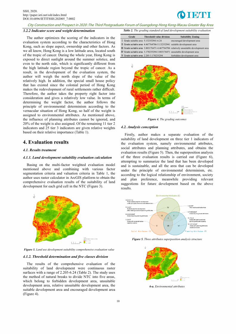
The results of the comprehensive evaluation of the suitability of land development were continuous raster surfaces with a range of 2.205-6.24 (Table 2). The study uses the method of natural breaks to divide NTC into five areas, which belong to forbidden development area, unsuitable development area, relative unsuitable development area, the suitable development area and encouraged development area (Figure 4).
Table 2. The grading standard of land development suitability evaluation
Grade Threshold value division Suitability Zoning ����de suitable area 5.132352941-6.24 encouraged development area ������������������ 4.467764706-5.132352941 suitable development area ������������������ 3.803176471-4.467764706 relatively unsuitable development area ������������������ 3.170235294-3.803176471 unsuitable development area ������������������ 2.205-3.170235294 forbidden development area
Figure 4. The grading outcomes
4.2. Analysis conception
Firstly, author makes a separate evaluation of the suitability of land development on three tier 1 indicators of the evaluation system, namely environmental attributes, social attributes and planning attributes, and obtains the evaluation results (Figure 5). Then, the superposition analysis of the three evaluation results is carried out (Figure 6), attempting to summarize the land that has been developed and is sustainable, and all the area that can be developed under the principle of environmental determinism, etc. according to the logical relationship of environment, society and plan preference, meanwhile providing relevant suggestions for future development based on the above results.
�Figure 5. Three attributes superposition analysis structure
�6-a. Environmental attributes
10
SSH, 2020. http://paper.ieti.net/ssh/index.html DOI:10.6896/IETITSSH.202005_7.0002
Suitability Evaluation of Land Development in Hong Kong New Territory Centre based on GIS
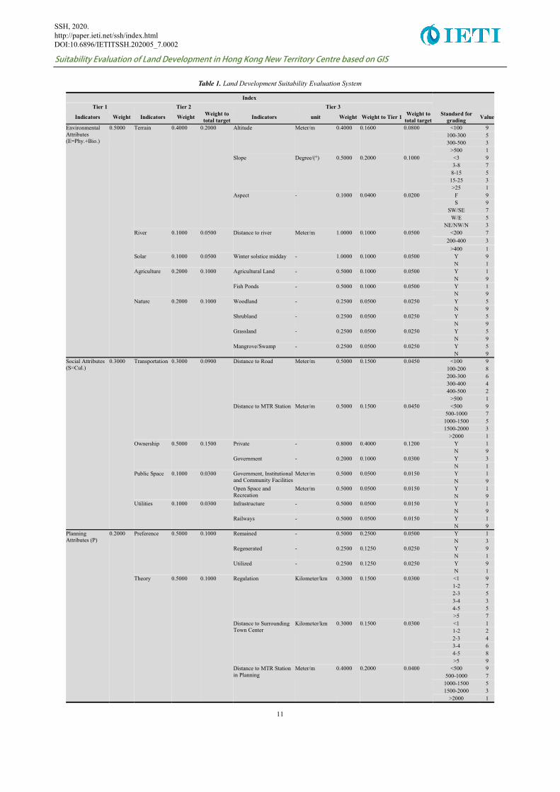
Table 1. Land Development Suitability Evaluation System
Index ��
Tier 1 Tier 2 Tier 3
Indicators Weight Indicators Weight Weight to total target Indicators unit Weight Weight to Tier 1 Weight to
total target Standard for
grading Value
Environmental Attributes (E=Phy.+Bio.)
0.5000 Terrain 0.4000 0.2000 Altitude Meter/m 0.4000 0.1600 0.0800 <100 9 100-300 5 300-500 3
>500 1 Slope Degree/(°) 0.5000 0.2000 0.1000 <3 9
3-8 7 8-15 5 15-25 3 >25 1
Aspect - 0.1000 0.0400 0.0200 F 9 S 9
SW/SE 7 W/E 5
NE/NW/N 3 River 0.1000 0.0500 Distance to river Meter/m 1.0000 0.1000 0.0500 <200 7
200-400 3 >400 1
Solar 0.1000 0.0500 Winter solstice midday - 1.0000 0.1000 0.0500 Y 9 N 1
Agriculture 0.2000 0.1000 Agricultural Land - 0.5000 0.1000 0.0500 Y 1 N 9
Fish Ponds - 0.5000 0.1000 0.0500 Y 1 N 9
Nature 0.2000 0.1000 Woodland - 0.2500 0.0500 0.0250 Y 5 N 9
Shrubland - 0.2500 0.0500 0.0250 Y 5 N 9
Grassland - 0.2500 0.0500 0.0250 Y 5 N 9
Mangrove/Swamp - 0.2500 0.0500 0.0250 Y 5 N 9
Social Attributes (S=Cul.)
0.3000 Transportation 0.3000 0.0900 Distance to Road Meter/m 0.5000 0.1500 0.0450 <100 9 100-200 8 200-300 6 300-400 4 400-500 2
>500 1 Distance to MTR Station Meter/m 0.5000 0.1500 0.0450 <500 9
500-1000 7 1000-1500 5 1500-2000 3
>2000 1 Ownership 0.5000 0.1500 Private - 0.8000 0.4000 0.1200 Y 1
N 9 Government - 0.2000 0.1000 0.0300 Y 3
N 1 Public Space 0.1000 0.0300 Government, Institutional
and Community Facilities Meter/m 0.5000 0.0500 0.0150 Y 1
N 9 Open Space and Recreation
Meter/m 0.5000 0.0500 0.0150 Y 1 N 9
Utilities 0.1000 0.0300 Infrastructure - 0.5000 0.0500 0.0150 Y 1 N 9
Railways - 0.5000 0.0500 0.0150 Y 1 N 9
Planning Attributes (P)
0.2000 Preference 0.5000 0.1000 Remained - 0.5000 0.2500 0.0500 Y 1 N 3
Regenerated - 0.2500 0.1250 0.0250 Y 9 N 1
Utilized - 0.2500 0.1250 0.0250 Y 9 N 1
Theory 0.5000 0.1000 Regulation Kilometer/km 0.3000 0.1500 0.0300 <1 9 1-2 7 2-3 5 3-4 3 4-5 5 >5 7
Distance to Surrounding Town Center
Kilometer/km 0.3000 0.1500 0.0300 <1 1 1-2 2 2-3 4 3-4 6 4-5 8 >5 9
Distance to MTR Station in Planning
Meter/m 0.4000 0.2000 0.0400 <500 9 500-1000 7
1000-1500 5 1500-2000 3
>2000 1
11
SSH, 2020. http://paper.ieti.net/ssh/index.html DOI:10.6896/IETITSSH.202005_7.0002
City Construction and Prospect in 2020 :The Third Postgraduate Forum of Guangdong-Hong Kong-Macau Greater Bay Area
�6-b. Social attributes
�6-c. Planning attributes
Figure 6. Three kinds of attributes individual suitability evaluation
4.3. Results analysis
4.3.1. The site has considerable potential for development
According to the statistics of the five grades of land development suitability areas, the encouraged development area and suitable development area account for more than 30% of the total research area, up to 29.84km2 (Table 3). In general, research area still possesses a considerable potential for development and requires planning and utilizing properly. It can be seen from Figure 4 that the areas of development potential are mainly concentrated near the expressway outside the study area and in the southwest of the study area. The suitable development areas in the southwest are continuous and conducive to the concentrated development.
Table 3. The statistics of suitable land for development in NTC
Grade Area/km�� Percentage Forbidden development area 27.33 30.02% Unsuitable development area 19.46 21.37% Relatively unsuitable development area 14.42 15.84% Suitable development area 12.93 14.20% Encouraged development area 16.91 18.57% Total 91.05 100.00%
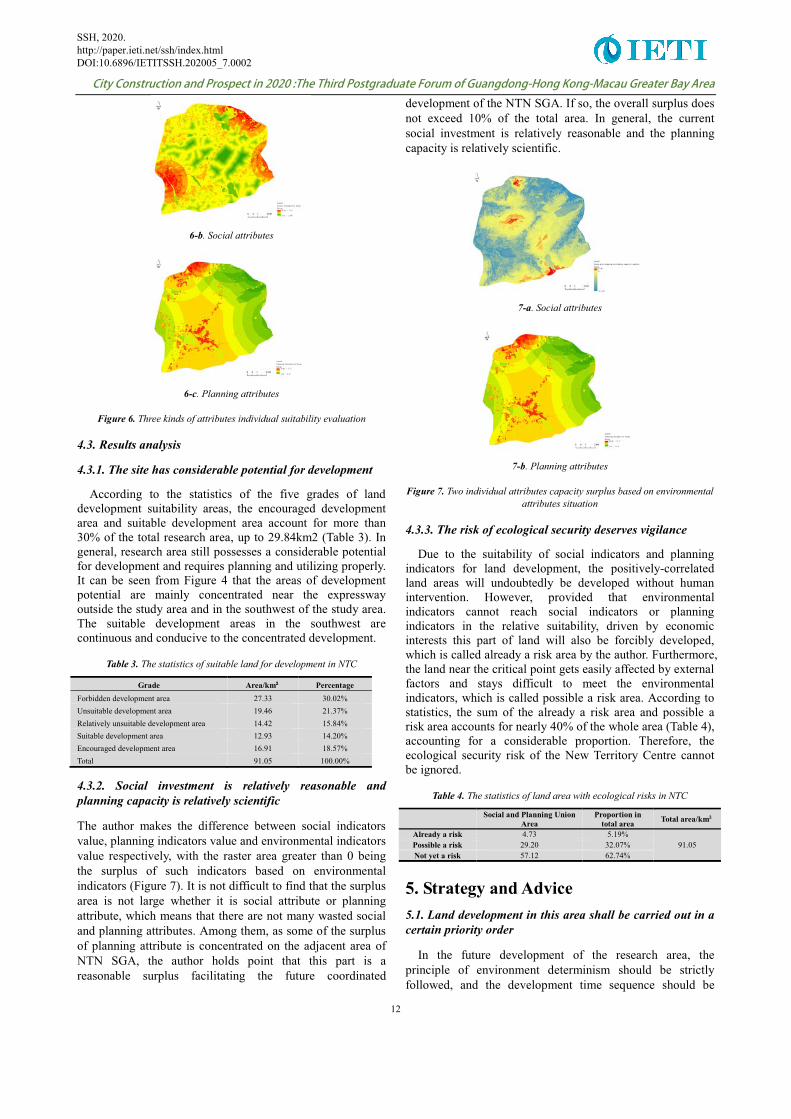
4.3.2. Social investment is relatively reasonable and planning capacity is relatively scientific
The author makes the difference between social indicators value, planning indicators value and environmental indicators value respectively, with the raster area greater than 0 being the surplus of such indicators based on environmental indicators (Figure 7). It is not difficult to find that the surplus area is not large whether it is social attribute or planning attribute, which means that there are not many wasted social and planning attributes. Among them, as some of the surplus of planning attribute is concentrated on the adjacent area of NTN SGA, the author holds point that this part is a reasonable surplus facilitating the future coordinated
development of the NTN SGA. If so, the overall surplus does not exceed 10% of the total area. In general, the current social investment is relatively reasonable and the planning capacity is relatively scientific.
�7-a. Social attributes
�7-b. Planning attributes
Figure 7. Two individual attributes capacity surplus based on environmental attributes situation
4.3.3. The risk of ecological security deserves vigilance
Due to the suitability of social indicators and planning indicators for land development, the positively-correlated land areas will undoubtedly be developed without human intervention. However, provided that environmental indicators cannot reach social indicators or planning indicators in the relative suitability, driven by economic interests this part of land will also be forcibly developed, which is called already a risk area by the author. Furthermore, the land near the critical point gets easily affected by external factors and stays difficult to meet the environmental indicators, which is called possible a risk area. According to statistics, the sum of the already a risk area and possible a risk area accounts for nearly 40% of the whole area (Table 4), accounting for a considerable proportion. Therefore, the ecological security risk of the New Territory Centre cannot be ignored.
Table 4. The statistics of land area with ecological risks in NTC
�� Social and Planning Union Area
Proportion in total area Total area/km�
Already a risk 4.73 5.19% 91.05 Possible a risk 29.20 32.07%
Not yet a risk 57.12 62.74%
5. Strategy and Advice 5.1. Land development in this area shall be carried out in a certain priority order
In the future development of the research area, the principle of environment determinism should be strictly followed, and the development time sequence should be
12
SSH, 2020. http://paper.ieti.net/ssh/index.html DOI:10.6896/IETITSSH.202005_7.0002

Suitability Evaluation of Land Development in Hong Kong New Territory Centre based on GIS
determined according to the amount of owning attributes in the area conforming to the capability of environmental attribute. That is to say, the priority area among the areas available for development should be the area of both social attributes and planning attributes, followed by the area of either social attributes or planning attributes, and finally the area of only environmental attributes. In this way, we can quickly identify the most cost-effective development areas in the future in an economical and efficient manner. The key point to be clear about lies in that all the area available for development is supposed to be the one that meet environmental requirements.
5.2. Neither the exist nor the potential threats should be ignored
According to the analysis above, it is easy to conclude that social attributes and planning attributes have a considerable surplus. What we should do is to reduce redundant infrastructure investment and radiation capacity of planning intentionally, and guard against the potential risks to the ecological environment caused by the surplus of social attributes and planning attributes.
5.3. Corresponding reduction mechanism should be developed
Based upon the research results, the area that is already a risk occupies a considerable proportion, i.e., part of the current natural land has been threatened by social attributes and planning attributes. In order to reduce or even eliminate such elements smoothly, the government ought to introduce relevant policies and establish a reduction mechanism of social attributes and planning attributes, so as to avoid adverse effects on the natural environment.
References [1] Carey D I. Development based on carrying-capacity: a strategy
for environmental protection. Global Environmental Change, 1993, 3(2): 140-148.
[2] Cheng Y, Zhu Q J, Dang X G, Liu F. Analysis of method of urban land-use suitability evaluation for disaster prevention based on GIS. Rock and Soil Mechanics, 2009, 30(2): 505-508.
[3] Chen W L, Zhang H O, Li S F, Wu Q T. Thoughts on the evaluation of the carrying capacity of resources and environmental and the territorial development suitability in the new era: based on the practice of Guangdong provincial evaluation. Guangdong Land Science, 2019, 18(2): 4-9.
[4] Duc Uy P, Nakagoshi N. Application of land suitability analysis and landscape ecology to urban greenspace planning in Hanoi, Vietnam. Urban Forestry & Urban Greening, 2008, 7(1): 25-40.
[5] Du H E, Li Z, Zheng Y. Research progress on assessment of resources and environment bearing capacity and suitability of land space development. China mining magazine, 2019, 28(2): 159-165.
[6] George M. Man and Nature. City of Cambridge: Harvard University Press, 1864
[7] He Q P. Establishment of index system of resource environmental carrying capacity in pearl river area. Chinese Journal of Agricultural Resources and Regional Planning, 2018, 39(7): 99-105.
[8] Qi Z X, Liao J J, Xu W H, Ni Y M. Suitability analysis of mountain settlements in Qinling using a GIS system. Acta Ecologica Sinica, 2015, 35(4): 1274-1283.
[9] Shao L Y, Chen R R, Hou J G, Chen F, Fu K. Suitability assessment on urban on urban construction land use, a case study in Rongchang of Chongqing city. Chinese Journal of Agricultural Resources and Regional Planning, 2013, 34(6): 86-92.
[10] Scott J M, Davis F, Csuti B, Noss R, Butterfield B, Groves C, Anderson H, Caicco S, D'Erchia F, Edwards T C, Ulliman J Jr, Wright R G. Gap analysis: a geographic approach to protection of biological diversity. Wildlife Monographs, 1993, 123: 3-41.
[11] Wang H, Shen Q P, Tang B S, Martin S. An integrated approach to supporting land-use decisions in site redevelopment for urban renewal in Hong Kong. Habitat International, 2013, 38: 70-80.
[12] Wang F, Xing S H. Evaluation of the suitability of land resources for spring peanut in Fujian Province on GIS platform. Chinese Journal of Eco-Agriculture, 2008, 16(2): 475-481.
Author Biographies 1. LI Weike is a master student in the City University of Hong Kong, majoring urban design and regional planning.
2. KE Zilin is a master student in the City University of Macau, majoring urban planning and design.
13
SSH, 2020. http://paper.ieti.net/ssh/index.html DOI:10.6896/IETITSSH.202005_7.0002