Embed Size (px)
Citation preview
SugarTrail : Indoor Navigation in RetailEnvironments without Surveys and Maps
Aveek Purohit, Zheng Sun, Shijia Pan, and Pei ZhangDepartment of Electrical and Computer Engineering
Carnegie Mellon University{aveek.purohit,zheng.sun,shijia.pan,pei.zhang}@sv.cmu.edu
Abstract—A system that helps people navigate in indoor envi-ronments on a fine-grained level can enable a variety of pervasivecomputing applications in retail environments. Existing indoornavigation systems rely on extensive RF tagging surveys andaccurate floor plans. These prerequisites are often impracticalin indoor environments.
In this paper, we present SugarTrail, a system for indoornavigation assistance in retail environments that minimizes theneed for active tagging and does not require existing maps. Byleveraging the structured movement patterns of shoppers in retailstore environments, the system provides higher accuracy thanexisting radio finger-printing approaches. With minimal setupand active user participation, the system automatically learnsuser movement pathways in indoor environments from radio-frequency and magnetic signatures. These pathways are clusteredand used to automatically build a navigable virtual roadmapof the environment. We present results from a campus testbedand from actual radio measurements collected in an operationalsupermarket to show that SugarTrail system can navigate userswith a success rate of > 85% and an average accuracy of 0.7m.
I. INTRODUCTION
Fine-grained indoor navigation can enable a variety ofpervasive computing applications in retail store environments.For example, using indoor navigation assistance, retail storescan guide consumers to their desired products or track move-ment patterns of users to fine-tune product placement. Thewidespread adoption of such navigation systems depends ontheir accuracy and ease of setup.
Indoor navigation is hard due to the difficulty in localizingpeople inside buildings, where GPS is not available and theenvironment is prone to multipath effects reducing the accu-racy of range-based localization techniques relying on sound orRF signal propagation. Approaches for indoor navigation havebeen proposed in literature, primarily using radio-frequency(RF) based localization systems [1], [23]. RF-fingerprintingmethods are popular for indoor retail or office environmentsbecause of their ability to largely use existing infrastructureof wireless access points. However, these systems have certainrequirements that make them impractical, in particular:
Need for Extensive Active Tagging of Fingerprints –To overcome the highly variable and noisy indoor environ-ment, prior radio-based localization systems involve extensivedeployment efforts in collecting RF-fingerprints, and taggingeach fingerprint with a location on a map. This is done man-ually during deployment or through crowd-sourcing [3], [15].This approach requires people with special devices actively
assigning physical locations to every RF-signature collected.Sufficient and repeated active user participation is impracticalin many application scenarios.
Reliance on Accurate/Updated Maps – Existing indoornavigation systems rely on locating users on a map and thenusing the map to find walkable pathways to the users’ desireddestination. Thus, navigation approaches based on localiza-tion systems require updated maps of the environment. Thisassumption of having updated indoor maps is not valid inmany applications scenarios. For example, retail stores andsupermarkets have soft demarcation between spaces, such ascubicles, furniture or aisles, which are not reflected in floorplans.
In this paper, we present SugarTrail, a system for indoornavigation assistance in retail environments that minimizes theneed for active tagging and does not require existing maps. Byleveraging the structured movement patterns of shoppers inretail store environments, the system provides higher accuracythan existing radio finger-printing approaches.
The system uses low-cost stationary sensor nodes equippedwith off-the-shelf radios, which can be casually placed in theenvironment by untrained personnel without location measure-ment. To acquire knowledge of the physical environment with-out a map, the system collects radio and compass signatures tocontinually record paths traversed by users (without any activeparticipation on the part of the user such as tagging). Usingthis information, paths are automatically aggregated into path-clusters and a navigable Virtual Roadmap (VRM) of the indoorenvironment is built by the system. Using this roadmap, thesystem guides users to their desired destination.
The key technical contributions of our system are,
• An algorithm that provides fine-grained indoor navigationguidance by automatically learning a virtual roadmap fromuser movement traces. The algorithm leverages the struc-tured movement patterns of retail environments to achievehigher accuracy than existing approaches.
• A novel technique for identifying user movement paths fromradio and magnetometer measurements that can overcomemulti-path distortions and magnetic interference common toindoor environments.
• Extensive experimental validation on campus as well as ina real supermarket during operational hours.
To fully evaluate our system in a realistic usage scenarios,we built the SugarTrail sensor node hardware and deployedour system, on campus, and in the New Wing supermarket in
ANCHORNODE
MOBILE NODE
SHELF / OBSTACLE
MOBILE NODE PATH
ROUND TRIP ToF MEASUREMENT
ø COMPASS MEASUREMENT
PATH P = {S1,S2,...,Sn}
4. SYSTEM CREATES USER PATH TRACE FROM SEQUENCE OF SIGNATURES
1. ANCHOR NODES ARE PLACED AT ARBITRARY LOCATIONS
SHELF / OBSTACLE
ANCHORNODE
2. USERS MOVE CARRYING MOBILE NODE
MOBILE NODE USER PATH POINT St = {r1,r2,...,rN,ø}
r1r3
r4r2
3. MOBILE NODES COLLECT POINT LOCATION (RToF) & COMPASS SIGNATURES
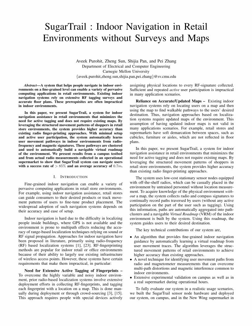
Fig. 1. The figure shows the process of recording user path traces in a retail store environment. 1) Anchor nodes are distributed in the environment withoutthe need to measure their location. 2) Mobile nodes attached to users move through the environment and 3) Mobile nodes periodically collect magnetometermeasurements and radio measurements from anchor nodes that are in range. 4) The sequence of signatures define a path and are transmitted to a base station.
USER A USER B
B
A
A3
A2
A1
B1
B2
B3
B4
A3
A2
B2
B3
B4
A3A1+
B1
B2
B3
B4
A2
1. TWO USER PATH TRACES A & B 2. SEGMENT USER PATH TRACES WITH A SINGLE DIRECTION ON AVERAGE
3. CLUSTER SIMILAR PATH SEGMENTS
4. CREATE ROADMAP GRAPH FROM CLUSTERS AND INTERCONNECTS
CLUSTER
A1 + B1
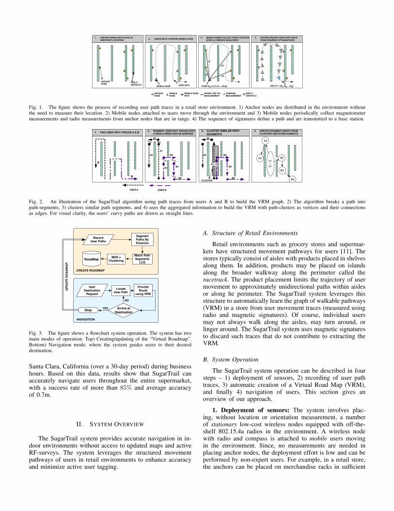
Fig. 2. An illustration of the SugarTrail algorithm using path traces from users A and B to build the VRM graph. 2) The algorithm breaks a path intopath-segments, 3) clusters similar path segments, and 4) uses the aggregated information to build the VRM with path-clusters as vertices and their connectionsas edges. For visual clarity, the users’ curvy paths are drawn as straight lines.
Match Path Segments
LCSMDS +
Clustering
Segment Paths By Direction
Provide Route
using VRMLocate
User Path
Arrive at Destination
Record User Paths
RoadMap
User Destination
Request
NAVIGATION
YES
NO
CREATE ROADMAP
UPDA
TE R
OAD
MAP
Stop
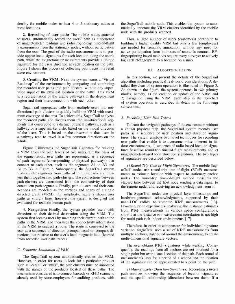
Fig. 3. The figure shows a flowchart system operation. The system has twomain modes of operation. Top) Creating/updating of the “Virtual Roadmap”.Bottom) Navigation mode, where the system guides users to their desireddestination.
Santa Clara, California (over a 30-day period) during businesshours. Based on this data, results show that SugarTrail canaccurately navigate users throughout the entire supermarket,with a success rate of more than 85% and average accuracyof 0.7m.
II. SYSTEM OVERVIEW
The SugarTrail system provides accurate navigation in in-door environments without access to updated maps and activeRF-surveys. The system leverages the structured movementpathways of users in retail environments to enhance accuracyand minimize active user tagging.
A. Structure of Retail Environments
Retail environments such as grocery stores and supermar-kets have structured movement pathways for users [11]. Thestores typically consist of aisles with products placed in shelvesalong them. In addition, products may be placed on islandsalong the broader walkway along the perimeter called theracetrack. The product placement limits the trajectory of usermovement to approximately unidirectional paths within aislesor along he perimeter. The SugarTrail system leverages thisstructure to automatically learn the graph of walkable pathways(VRM) in a store from user movement traces (measured usingradio and magnetic signatures). Of course, individual usersmay not always walk along the aisles, may turn around, orlinger around. The SugarTrail system uses magnetic signaturesto discard such traces that do not contribute to extracting theVRM.
B. System Operation
The SugarTrail system operation can be described in foursteps – 1) deployment of sensors, 2) recording of user pathtraces, 3) automatic creation of a Virtual Road Map (VRM),and finally 4) navigation of users. This section gives anoverview of our approach.
1. Deployment of sensors: The system involves plac-ing, without location or orientation measurement, a numberof stationary low-cost wireless nodes equipped with off-the-shelf 802.15.4a radios in the environment. A wireless nodewith radio and compass is attached to mobile users movingin the environment. Since, no measurements are needed inplacing anchor nodes, the deployment effort is low and can beperformed by non-expert users. For example, in a retail store,the anchors can be placed on merchandise racks in sufficient
density for mobile nodes to hear 4 or 5 stationary nodes atmost locations.
2. Recording of user path: The mobile nodes attachedto users, automatically record the users’ path as a sequenceof magnetometer readings and radio round-trip time-of-flightmeasurements from the stationary nodes, without participationfrom the user. The goal of the radio measurements is to pro-vide approximate signatures for each location along the user’spath, while the magnetometer measurements provide a uniquesignature for the users direction at each location on the path.Figure 1 shows this process of collecting path traces in a retailstore environment.
3. Creating the VRM: Next, the system learns a “VirtualRoadmap” of the environment by comparing and combiningthe recorded user paths into path-clusters, without any super-vised input of the physical location of the paths. This VRMis a representation of the usable pathways in the deploymentregion and their interconnections with each other.
SugarTrail aggregates paths from multiple users into uni-directional path-clusters to quickly build the VRM with maxi-mum coverage of the area. To achieve this, SugarTrail analyzesthe recorded paths and divides them into uni-directional seg-ments that correspond to a distinct physical pathway, such as ahallway or a supermarket aisle, based on the modal directionof the users. This is based on the observation that users ina pathway tend to travel in a few common directions on thewhole.
Figure 2 illustrates the SugarTrail algorithm for buildinga VRM from the path traces of two users. On the basis ofthe segmentation, user paths are represented as a sequenceof path segments (corresponding to physical pathways) thatconnect to each other, such as the segments A1 to A3 andB1 to B3 in Figure 2. Subsequently, the SugarTrail systemfinds similar segments from paths of multiple users and clus-ters them together into path-clusters. The connections betweenpath-clusters are determined from the connectivity of theirconstituent path segments. Finally, path-clusters and their con-nections are modeled as the vertices and edges of a singledirected graph (VRM). For simplicity, figure 2 shows userpaths as straight lines, however, the system is designed andevaluated for realistic human paths
4. Navigation: Finally, the system provides users withdirections to their desired destination using the VRM. Thesystem first locates users by matching their current path to thepaths in the VRM, and then uses the connectivity informationin the VRM to suggest a route. The route is conveyed to theuser as a sequence of direction prompts based on compass di-rections that relative to the user’s local magnetic field (learnedfrom recorded user path traces).
C. Semantic Annotation of VRM
The SugarTrail system automatically creates the VRM.However, in order for users to look for a particular productsuch as “cereal” or “milk”, the path clusters must be annotatedwith the names of the products located on these paths. Themechanism considered is to connect barcode or RFID scanners,already used by store employees for auditing products, with
the SugarTrail mobile node. This enables the system to auto-matically annotate the VRM clusters identified by the mobilenode with the products scanned.
Thus, a large number of users (customers) contribute tobuilding a higher quality VRM but only a few (employees)are needed for semantic annotation, without any need foractive participation from both sets of users. In contrast, RF-fingerprinting based methods require every surveyer to activelytag each rf-fingerprint to a location on a map.
III. ALGORITHM DESIGN
In this section, we present the details of the SugarTrailalgorithm including practical real-world considerations. A de-tailed flowchart of system operation is illustrated in Figure 3.As shown in the figure, the system operates in two primarymodes, namely, 1) the creation or update of the VRM and2) navigation using the VRM. Each step in the flowchartof system operation is described in detail in the followingsubsections.
A. Recording User Path Traces
To learn the navigable pathways of the environment withouta known physical map, the SugarTrail system records userpaths as a sequence of user location and direction signa-tures. The system employs two novel techniques for recordinguser paths that enable it to overcome noise inherent in in-door environments, 1) sequence of radio-based location signa-tures based on round-trip time-of-flight measurements, and 2)magnetometer-based local direction signatures. The two typesof signatures are described below.
1) Round-Trip Time-of-Flight Signatures: The mobile Sug-arTrail nodes use round-trip time-of-flight (RToF) measure-ments to estimate location with respect to stationary anchornodes. The round-trip time-of-flight method measures theelapsed time between the host node sending a data signal tothe remote node, and receiving an acknowledgment from it.
The SugarTrail nodes use physical layer timestamps andhardware-generated acknowledgments, supported by theirnano-LOC radios, to compute RToF measurements [13].However, prior experiments analyzing the distance estimatesfrom RToF measurements in various space configurations,show that the distance-to-measurement correlation is not highfor multi-path rich indoor environments [17].
Therefore, in order to compensate for individual signaturevariation, SugarTrail uses a set of RToF measurements frommultiple anchors, distributed around the environment, to createmulti-dimensional signature vectors.
The user obtains RToF signatures while walking. Conse-quently, the readings from all anchors are not obtained for asingle point but over a small section of the path. Each round ofmeasurements lasts for a period of 1 second and the locationof the signature can be approximated to a point on the path.
2) Magnetometer Direction Signatures: Recording a user’spath involves knowing the sequence of location signaturesand the spatial relationship (direction) between them. If a
navigation system knows the location of the user in Carte-sian coordinates, the users direction of movement can be de-termined directly. However, since SugarTrail navigates userswithout existing maps, the spatial relationship between nodesmust be measured. SugartTrail uses magnetometer signaturesto determine the spatial relationship.
In indoor environments, magnetometers can be signifi-cantly affected by soft-iron effects due to surrounding metallicstructures such as cubicles, appliances, support beams, etc., aswell as by hard-iron effects due to power lines [5]. To dealwith the indoor magnetic interferences, SugarTrail uses themagnetometer as a relative and local direction signature asopposed to a global orientation measurement. Specifically, thesystem uses raw magnetometer direction signatures to identifytwo major features of the user path,
• Points where the user changes direction corresponding toa transition between pathways. This is used to detect pathjunctions where paths intersect. These junctions are laterused to divide user path traces into segments that have asingle direction.
• User path segments that have similar directions for de-termining co-located path segments and aligning them in thematching phase.SugarTrail leverages two types of location-dependent sig-
natures, namely RToF signatures and magnetometer readings.Suppose a user walks along a path P , each single location pointpi will be represented by a N -dimensional RToF signaturevector �!
Ri = {r1, r2, . . . , rN}, (1)
where ri is the RToF measurement from the ith anchor and Nis the total number of anchors in the environment, as well asa direction measurement from the magnetometer �i, togetherforming a signature set
�!Si = {�!Ri : �i}. We assume that the
orientation of the mobile node is fixed with respect to the user.This assumption is valid for our usage scenarios, where usershold the nodes in their hands or the nodes are mounted onshopping carts.
B. Segmentation of Paths
After recording user path signatures, the system builds theVRM representing usable pathways and their interconnectionswith each other. To achieve this, SugarTrail analyzes recordedpaths and divides them into segments that correspond to dis-tinct physical pathways, such as a supermarket aisle.
To isolate path segments belonging to the same physicalpathway, we observe that human motion along physical path-ways (such as aisles) tends to be limited to a few directions ona macro-scale. For example, people tend to move forward orbackward in an aisle. While, on a micro-scale people maymove in diverse directions resembling a random way-pointwalk, by filtering out the micro-scale motion, the system canextract path segments having a single major direction.
Based on the above intuition, SugarTrail first computes thedifference in direction between consecutive points in a path,then detects points at which a significant change in directionoccurs. These points are marked as candidate turn points.To reduce false detection of segments caused by micro-scaledirectional variations, SugarTrail computes the modes ml and
mr of two sliding windows before and after each candidateturn point along a path trace. The mode of the first windowml is then compared to that of the second window mr. Whenthe difference exceeds a direction change threshold �mTHR,the point is marked as a valid turn point. Finally the paths aresegmented at each of the valid turn points. The pseudo-codeis described in Algorithm Box 1.
Algorithm 1 Path Segmentation1: k=0, do the following for each path Pi (i 2 {1, I})2: for each point pj in path Pi do3: Find difference in direction between consecutive points pj and
pj+1: ��j,j+1 = �j+1 � �j
4: if ��j,j+1 >� �THR then5: Mark the turn index tk as j + 1, then k = k + 1.6: end if7: end for8: for each turn index tk (k 2 {1,K}) do9: Find the mode over sliding window before tk:
ml = mode({�tk�win size:tk})10: Find the mode over sliding window after tk:
mr = mode({�tk:tk+win size})11: Find difference �m = abs(ml �mr)12: if �m >� mTHR then13: Segment path Pi at point ptk14: end if15: end for
C. Determining Path Segment Similarity
SugarTrail measures the similarity of pair-wise path seg-ments so that it can group physically proximate path segmentsinto path-clusters. This process comprises of two steps. (1)The first step measures the similarity of pair-wise signaturesin two path segments. (2) After acquiring the similarity of allthe corresponding signatures in the two path segments, thesystem uses a modified longest common subsequence (LCS)algorithm to compute a similarity score between paths.
1) Signature-Wise Distance Metric: Based on the natureof obtained signatures, SugarTrail uses a hybrid metric tocompute signature-wise distance consisting of a weighted sumof hamming and euclidean distance between signatures.
First, a mobile node may or may not be in communicationrange from a given anchor node depending on its location.From a signature point of view, an out-of-range or failedmeasurement leads to nulls in the RToF signature vector
�!Ri.
To quantitatively measure this connectivity difference of RToFmeasurements between point pi and pj , we derive the Ham-ming distance
Hi,j =
�!Ri �
�!Rj
N, (2)
where the “�” operation counts the number of non-null com-mon elements in two vectors. The Hamming distance com-putes the similarity of visible anchors from the two locationsignatures.
Second, if two locations are physically close, the magnitudeof RToF measurements from the same anchor node should besimilar. Based on our analysis of location signatures, this trans-lates to a small Euclidean distance between the N -dimensionalRToF signatures.
The normalized Euclidean distance, given by,
di,j =k�!Ri �
�!Rjk
# of visible common anchors(3)
measures the distance in RToF measurements from anchorsvisible in both signature vectors. To compensate for RToFmeasurement variance, in the implementation of the system wepenalize faraway location signatures that yield small Euclideandistances by non-linearizing the Euclidean distance di,j usinga Sigmoidal transformation, i.e.
d0i,j =1
1 + e�di,j. (4)
Finally, the signature-wise signature distance is computed asa weighted sum of both the Hamming and the Euclidean dis-tances, i.e.
Di,j =d0i,j + !Hi,j
1 + !, (5)
where ! is the weight to balance the Euclidean and the Ham-ming distance. During the evaluation, we empirically set ! to0.5, such that the signature distance has a high correlation withthe physical location distance.
2) Path-wise Similarity Metric: After computing the dis-tance between signatures, the system needs to compute a sim-ilarity score for path-pairs that comprise of those signatures.This similarity score is used to group path segments belongingto the same physical pathways.
Since user path segments belonging to the same physicalpathway should be clustered, we use the following criteria todesign a suitable similarity metric for path segments,
• High Point-Wise Similarity: Users moving along the samephysical pathway are likely to observe similar location sig-natures. This means the path segment similarity must con-sider the signature similarity of individual location pointson the paths.
• Length Independent: Users moving on the same physicalpathway may travel over different portions of the pathway.These partial path segments must be clustered together. Inother words, the path segment similarity must be indepen-dent of the length of the path segment.
• Robust Against Path Warping: User movement varies inspeed as well direction on a micro-scale. As the SugarTrailsystem does not use any inertial motion measurements, thepath segment similarity should ignore warping of the path.In other words, skipping up to a specified maximum numberof points to determine highest similarity should be possible.
To satisfy the above requirements, SugarTrail representseach user’s path as a time-series of sequential signature anddirection data and employs a modified version of the LongestCommon Sequence (LCS) algorithm [2] to obtain similarityscores. Algorithm Box 2 describes the modified LCS algo-rithm.
Our modified LCS algorithm, uses the previously describedsignature distance metric for element-wise comparisons. Basedon these comparisons, the algorithm increments the similarityscore if the difference of the signature vectors Di,j and theindex difference between the location points of the two pathsis less than ✏ and �, respectively.
✏ and � are thresholds that relax the correspondence re-quirement of signature vectors and point indices. ✏ is chosenthrough empirical measurements of RToF signature distancefor points that are within 1m of each other. delta is chosenaccording to the average walking speed of humans that limitsthe amount of warping that is permitted in matching two paths.
Algorithm 2 Modified LCS Subsequence Matching1: for each pair of path segments Pm and Pn do2: Initialize the LCS matrix as an I-row, J-column all-zero ma-
trix, where I and J are the numbers of location points, i.e.lengths, of Pm and Pn
3: for each pair of points pmi and pnj in Pm and Pn do4: Find signature-wise signature distance Di,j between pmi and
pnj using our hybrid distance metric.5: if Di,j < ✏ and |j � i| < � then6: Update the element at row i, column j in the LCS matrix
as Li,j = e�D2i,j + Li�1,j�1
7: else8: Li,j = max(Li�1,j , Li,j�1)9: end if
10: end for11: end for12: Compute the LCS score for Pm and Pn as LI,J
min(I,J)
D. Multidimensional Scaling & Clustering
The system requires the clustering of similar paths asnodes of the VRM graph. Path signatures depend on distortedmagnetometer readings that are not symmetrical for oppositedirections. Consequently, the direction of traversing a pathaffects its signature and a dual graph is created. SugarTrail usesthe K-means algorithm to cluster paths. Since, the paths are notpoints in Cartesian space, the system employs an intermediatestep that uses the multi-dimensional scaling (MDS) algorithmto represent each path as a point in a n-dimensional Cartesianspace [19].
Using the LCS similarity score matrix, the MDS algorithmcreates a configuration of relative coordinates for the points,such that the Euclidean distances between them can approx-imately represent the original distance matrix. The K-meansalgorithm is then applied to the path coordinates to groupthem into path-clusters. The maximum number of clusters kis chosen based on the number of unidirectional pathways inthe retail store.
E. Navigation
The SugarTrail system clusters all user collected path seg-ments to create nodes of the VRM graph. It records the con-nection between individual path segments in a users path tocreate a connection matrix representing the edges. The systemuses the VRM to route users from any designated point in themap to the desired destination.
1) Localization Over Paths: To navigate users, SugarTrailneeds to determine their starting position, track whether theyfollow the navigation path, and note when they reach their des-tination. Algorithm 3 shows the steps involved in computingthe alignment of two paths, where Pn is the user’s current pathand Pm is a recorded path with the best overall similarity scoreto Pn. Using the LCS path matching algorithm, the system
POINT ON PATH SEGMENT W/ MEASURED DIRECTION
TRUE AVG DIREC.OF CLUSTER
MAJOR CLUSTER (12 SEGS)
MAJOR CLUSTER(14 SEGS)
MAJOR CLUSTER(22 SEGS)
MAJOR CLUSTER(10 SEGS)
OUTLIERS(2 SEGS)
OUTLIERS(1 SEG)
CLUSTER 1 CLUSTER 2
CLUSTER 4CLUSTER 3
ANCHOR LOCATION
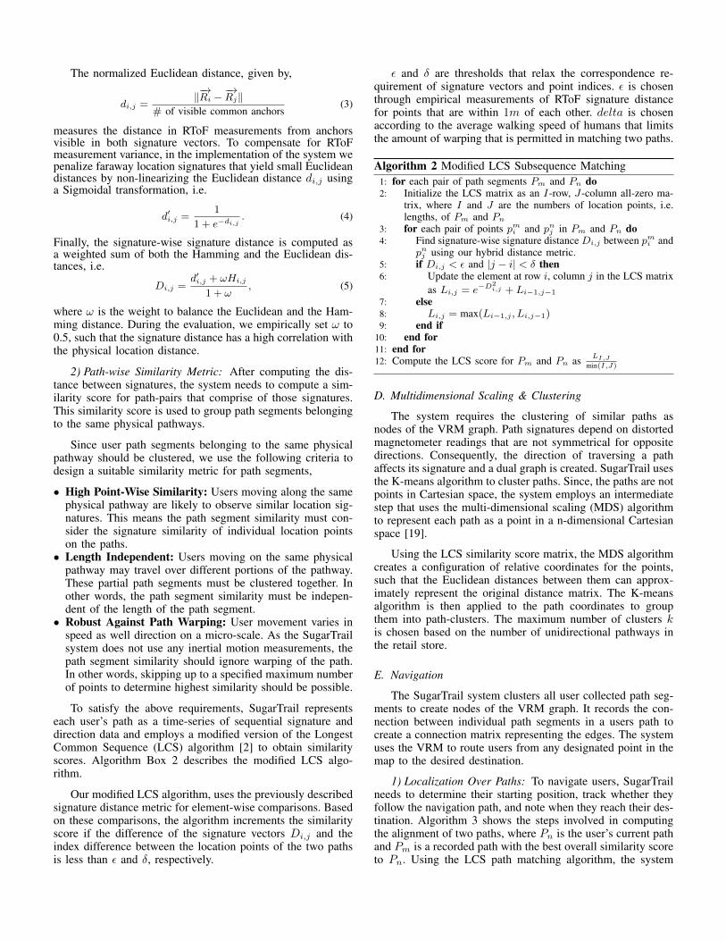
Fig. 4. Shows the clustering of path segments plotted against ground-truthlocations in the T-shaped campus hallway. The segments grouped in the wrongcluster are highlighted in red.
locates the user by finding the best alignment of the currentuser path segment with recorded clusters of path segments.Subsequently, the system guides users to the destination byprompting them the next direction to travel in.
Algorithm 3 Modified LCS Path Alignment1: for each path pair Pm and Pn do2: Initialize Pm’s index counter to i = 13: Initialize Pn’s index counter to j = 14: Initialize aligned path length to k = 15: while i Length(Pm) and j Length(Pn) do6: if Di,j ✏ and |j � i| � then7: j = j + 18: else if Li+1,j � Li,j+1 then9: i = i+ 1
10: else11: j = j + 112: end if13: end while14: end for
Localization of a user on a recorded path determines theaccuracy of navigation. The performance of the system and it’sdependence on various parameters is evaluated in the followingsection.
IV. EVALUATION AND RESULTS
In this section, we present our evaluation methodologyand experimental results. First, we validate the performance ofthe SugarTrail system in large-scale deployment. Second, wecompare SugarTrail to an ideal system with access to accuratelocations. And third, we analyze the effect of environmentalconditions and amount of training data on performance.
A. Small-Scale Campus Experiment
To validate the clustering phase of SugarTrail, we createda small-scale live testbed in a single-intersection (T-shapedcampus) hallway. This experiment enables us to determine ifuser traces can be segmented correctly and grouped into path-clusters corresponding to physical pathways.
The testbed has 10 anchors placed along the walls, dis-tributed over the hallway, with no position measurements. The
RACETRACK
RACETRACK
1 2 3 4 5 6 7
8
9FROZEN FOOD
REFRIGERATORS
METAL RACKS
SOFT PRODUCEISLES
AISL
ES
CHECKOUT COUNTERS
METAL UTENSILS
CEREAL TEA/COFFEE
COOKIES
CONDIMENTS
OPENFREEZER
ANCHOR NODES
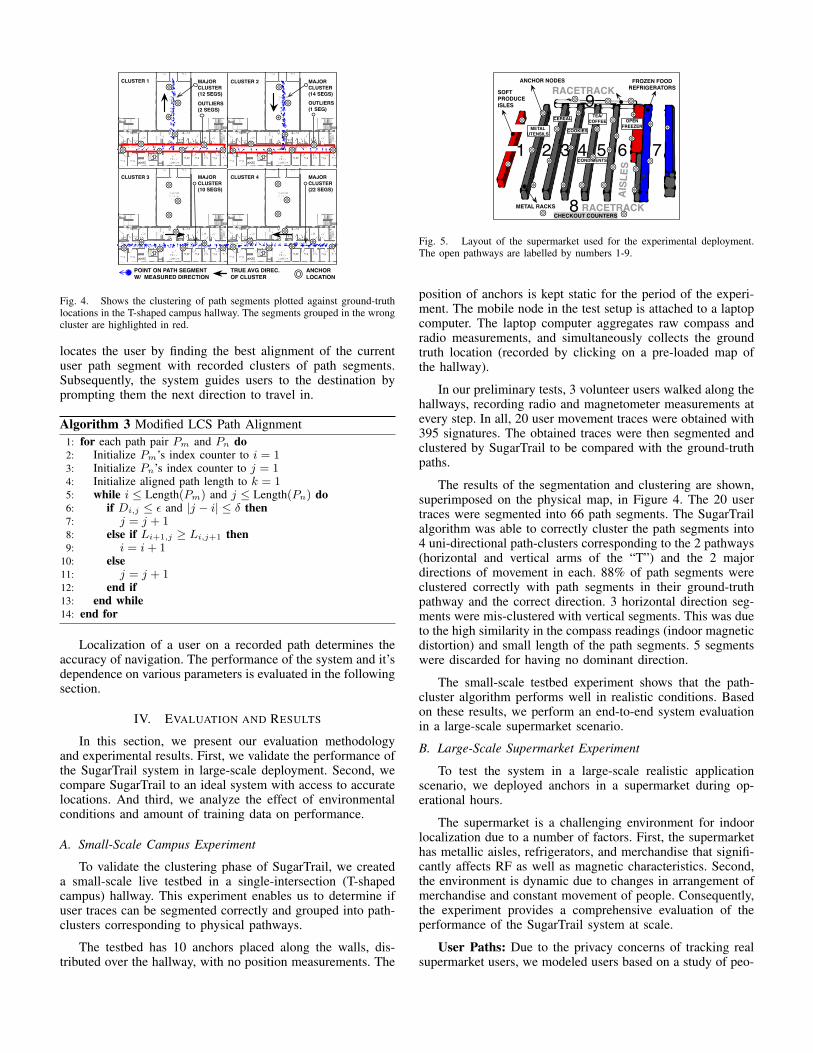
Fig. 5. Layout of the supermarket used for the experimental deployment.The open pathways are labelled by numbers 1-9.
position of anchors is kept static for the period of the experi-ment. The mobile node in the test setup is attached to a laptopcomputer. The laptop computer aggregates raw compass andradio measurements, and simultaneously collects the groundtruth location (recorded by clicking on a pre-loaded map ofthe hallway).
In our preliminary tests, 3 volunteer users walked along thehallways, recording radio and magnetometer measurements atevery step. In all, 20 user movement traces were obtained with395 signatures. The obtained traces were then segmented andclustered by SugarTrail to be compared with the ground-truthpaths.
The results of the segmentation and clustering are shown,superimposed on the physical map, in Figure 4. The 20 usertraces were segmented into 66 path segments. The SugarTrailalgorithm was able to correctly cluster the path segments into4 uni-directional path-clusters corresponding to the 2 pathways(horizontal and vertical arms of the “T”) and the 2 majordirections of movement in each. 88% of path segments wereclustered correctly with path segments in their ground-truthpathway and the correct direction. 3 horizontal direction seg-ments were mis-clustered with vertical segments. This was dueto the high similarity in the compass readings (indoor magneticdistortion) and small length of the path segments. 5 segmentswere discarded for having no dominant direction.
The small-scale testbed experiment shows that the path-cluster algorithm performs well in realistic conditions. Basedon these results, we perform an end-to-end system evaluationin a large-scale supermarket scenario.
B. Large-Scale Supermarket Experiment
To test the system in a large-scale realistic applicationscenario, we deployed anchors in a supermarket during op-erational hours.
The supermarket is a challenging environment for indoorlocalization due to a number of factors. First, the supermarkethas metallic aisles, refrigerators, and merchandise that signifi-cantly affects RF as well as magnetic characteristics. Second,the environment is dynamic due to changes in arrangement ofmerchandise and constant movement of people. Consequently,the experiment provides a comprehensive evaluation of theperformance of the SugarTrail system at scale.
User Paths: Due to the privacy concerns of tracking realsupermarket users, we modeled users based on a study of peo-
0102030405060708090
100
100 200 300 400Number of Training Paths
Succ
ess
Rat
e (%
)
Fig. 6. The figure shows a box plot (median,25th and 75th percentiles) of the success rate ofnavigation obtained by different number of pathsfor training data.
0 2 4 6 8 10 120
0.10.20.30.40.50.60.70.80.9
1
Navigation Error (m)
Prob
abilit
y of
Erro
r
100 Paths200 Paths300 Paths400 Paths
Fig. 7. Figure shows the CDF of navigation errorobtained by the SugarTrail system over the entiresupermarket area.
0 1 2 3 4 5 6 7 8 9 10 11 12 13 14 150
0.2
0.4
0.6
0.8
1
Prob
abilit
y
Number of Navigation Steps
SugarTrail (No Map)Ideal Visual Search (No Map)Ideal (Perfect Location + Map)
Fig. 8. The figure shows the CDF of the numberof navigation steps required to navigate a user be-tween 1000 randomly chosen start and destinationpoint pairs.
ple movement in supermarkets [11]. The modeled users travelthrough the store and collect measurements corresponding totheir locations.
Real Measurements: The modeled users obtain measure-ments from a database of previously collected high granularitysensor readings. The database of ground truth sensor readingsis created by collecting real radio and magnetometer measure-ments over a dense square grid (each point 0.6m apart fromothers) in all walkable aisles in the 26m⇥24m supermarket.These readings were collected in presence of shoppers andother supermarket activity.
Having validated the ability of SugarTrail to segment andcluster actual human paths in the campus testbed, the super-market experiment allows us to scale the system to a largenumber of paths without sacrificing the fidelity of the environ-ment’s RF and magnetic characteristics.
1) Experiment Setup: For our experiments, we deployed30 stationary anchors in the 26m ⇥ 24m New Wing Yuansupermarket in Santa Clara, CA. The anchors were placed atlocations on the shelves but distributed over the area of thesupermarket. Figure 5 shows the layout of the supermarketand arrangement of equipment and produce.
To create a database of RToF signatures and magnetometerreadings for pathways in the entire store (i.e. wherever walkingis possible), with the same setup as the campus experiment,the system collected measurements on a grid of 0.6m. 1589distinct locations were measured from the entire store. Atevery location, 20 distinct readings were obtained for RToFsignatures as well magnetometer measurements, to capture thevariance, creating a database of 31780 readings. 75% of thesewere used as part of the training data for SugarTrail, while 25%were used for the evaluation data set. In our experiments, weobserved that signatures generally contain an average of 11(min: 6, max: 15) anchor readings.
2) User Mobility Model: The mobility model used to gen-erate user paths for the evaluation comprises of two compo-nents – a macro-model, based on a comprehensive study ofover 8000 human motion paths in a supermarket by Larsen et.al. [11], which determines the macro-scale direction of usersover the aisles and the perimeter of the store; and a micro-model, based on biased the random waypoint model (RWP),which determines the individual step size and direction whena user travels along a path. The RWP model is frequently usedto simulate random human motion for Ad-hoc networks [18].
C. Performance Analysis
To exhaustively evaluate the performance of the SugarTrailsystem, we overlaid measured signatures in the supermarketwith model generated user paths. A subset (75%) of the datais used for initial training and (25%) is used for testing.
400 user paths are used in the supermarket test environ-ment for the learning phase of the SugarTrail system. Ad-ditional paths and signature data is used for the evaluation.This represents about half-a-day’s of consumer traffic in amoderately busy supermarket and is a reasonable setup timefor the SugarTrail system. Each user path traversed between1-5 pathways in the supermarket and consisted of about 150-300 steps of varying lengths. The length of a user step wasallowed to vary over the normal human stride length of 0m to1.2m following a uniform distribution. The pause time betweensteps was allowed to vary from 1 sec to 2 minutes.
Every user collected RToF and magnetometer measure-ments every 2 seconds. The interval of 2 seconds was de-rived to approximately capture user steps at an average paceof 0.5m/s, corresponding to leisurely human walking speed.However, as the stride length is variable the system does notalways get measurements at every user step, as is expectedin case of real human users. The algorithm makes no strictassumption about the human motion model and is thereforedesigned to be robust to such variations.
The user path training data set is provided as input to theSugarTrail algorithm, which in turn builds the correspondingVRM. A new set of users (different from the training dataset) is used to query the SugarTrail system and follow naviga-tion directions between randomly selected start and destinationpoints. The performance of the system is evaluated based onthe success rate of the navigation, the accuracy of navigation,and the number of steps in the navigation route. These metricsare further defined in the following subsections.
1) Metric – Navigation Success Rate: The SugarTrail sys-tem guides users by providing a route consisting of a sequenceof path-clusters, and a set of direction prompts (based onthe expected user’s local raw compass reference reading) tonavigate along those clusters. We define the navigation successrate as the percentage of times a user is guided correctly from astart point to the proximity of user’s desired destination point.
Specifically, an instance of user navigation is designated asa success if the following conditions are satisfied – First, the
user is guided into the correct physical pathways as the desireddestination point. Second, the user is not prompted to take aninvalid direction (obstructed path) at any point along the route.Finally, the user is not guided into any incorrect pathwaysalong the route. Such unexpected pathways may arise due toinconsistencies in the map or inaccuracy of localization.
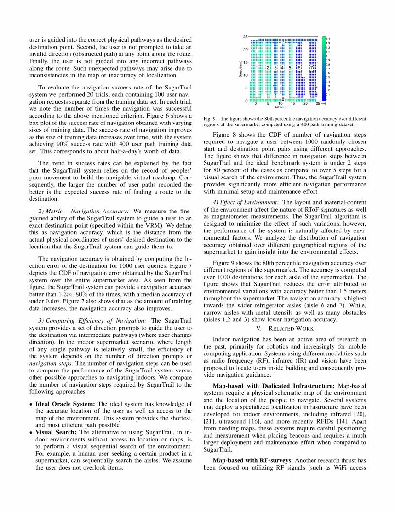
To evaluate the navigation success rate of the SugarTrailsystem we performed 20 trials, each containing 100 user navi-gation requests separate from the training data set. In each trial,we note the number of times the navigation was successfulaccording to the above mentioned criterion. Figure 6 shows abox plot of the success rate of navigation obtained with varyingsizes of training data. The success rate of navigation improvesas the size of training data increases over time, with the systemachieving 90% success rate with 400 user path training dataset. This corresponds to about half-a-day’s worth of data.
The trend in success rates can be explained by the factthat the SugarTrail system relies on the record of peoples’prior movement to build the navigable virtual roadmap. Con-sequently, the larger the number of user paths recorded thebetter is the expected success rate of finding a route to thedestination.
2) Metric - Navigation Accuracy: We measure the fine-grained ability of the SugarTrail system to guide a user to anexact destination point (specified within the VRM). We definethis as navigation accuracy, which is the distance from theactual physical coordinates of users’ desired destination to thelocation that the SugarTrail system can guide them to.
The navigation accuracy is obtained by computing the lo-cation error of the destination for 1000 user queries. Figure 7depicts the CDF of navigation error obtained by the SugarTrailsystem over the entire supermarket area. As seen from thefigure, the SugarTrail system can provide a navigation accuracybetter than 1.3m, 80% of the times, with a median accuracy ofunder 0.6m. Figure 7 also shows that as the amount of trainingdata increases, the navigation accuracy also improves.
3) Comparing Efficiency of Navigation: The SugarTrailsystem provides a set of direction prompts to guide the user tothe destination via intermediate pathways (where user changesdirection). In the indoor supermarket scenario, where lengthof any single pathway is relatively small, the efficiency ofthe system depends on the number of direction prompts ornavigation steps. The number of navigation steps can be usedto compare the performance of the SugarTrail system versusother possible approaches to navigating indoors. We comparethe number of navigation steps required by SugarTrail to thefollowing approaches:
• Ideal Oracle System: The ideal system has knowledge ofthe accurate location of the user as well as access to themap of the environment. This system provides the shortest,and most efficient path possible.
• Visual Search: The alternative to using SugarTrail, in in-door environments without access to location or maps, isto perform a visual sequential search of the environment.For example, a human user seeking a certain product in asupermarket, can sequentially search the aisles. We assumethe user does not overlook items.
0 5 10 15 20 250
5
10
15
20
25
Length(m)
Breadth(m)
1 2 3 4 5 6 7
8
9
(m)00.10.20.30.40.50.60.70.80.911.11.21.31.4
Fig. 9. The figure shows the 80th percentile navigation accuracy over differentregions of the supermarket computed using a 400 path training dataset.
Figure 8 shows the CDF of number of navigation stepsrequired to navigate a user between 1000 randomly chosenstart and destination point pairs using different approaches.The figure shows that difference in navigation steps betweenSugarTrail and the ideal benchmark system is under 2 stepsfor 80 percent of the cases as compared to over 5 steps for avisual search of the environment. Thus, the SugarTrail systemprovides significantly more efficient navigation performancewith minimal setup and maintenance effort.
4) Effect of Environment: The layout and material-contentof the environment affect the nature of RToF signatures as wellas magnetometer measurements. The SugarTrail algorithm isdesigned to minimize the effect of such variations, however,the performance of the system is naturally affected by envi-ronmental factors. We analyze the distribution of navigationaccuracy obtained over different geographical regions of thesupermarket to gain insight into the environmental effects.
Figure 9 shows the 80th percentile navigation accuracy overdifferent regions of the supermarket. The accuracy is computedover 1000 destinations for each aisle of the supermarket. Thefigure shows that SugarTrail reduces the error attributed toenvironmental variations with accuracy better than 1.5 metersthroughout the supermarket. The navigation accuracy is highesttowards the wider refrigerator aisles (aisle 6 and 7). While,narrow aisles with metal utensils as well as many obstacles(aisles 1,2 and 3) show lower navigation accuracy.
V. RELATED WORK
Indoor navigation has been an active area of research inthe past, primarily for robotics and increasingly for mobilecomputing application. Systems using different modalities suchas radio frequency (RF), infrared (IR) and vision have beenproposed to locate users inside building and consequently pro-vide navigation guidance.
Map-based with Dedicated Infrastructure: Map-basedsystems require a physical schematic map of the environmentand the location of the people to navigate. Several systemsthat deploy a specialized localization infrastructure have beendeveloped for indoor environments, including infrared [20],[21], ultrasound [16], and more recently RFIDs [14]. Apartfrom needing maps, these systems require careful positioningand measurement when placing beacons and requires a muchlarger deployment and maintenance effort when compared toSugarTrail.
Map-based with RF-surveys: Another research thrust hasbeen focused on utilizing RF signals (such as WiFi access
points, or Bluetooth) in office environments to provide local-ization. These systems fingerprint each indoor location usingreceived signal strength (RSS) measurements from multipleaccess points. A location database of such fingerprints is cre-ated through manual surveys, active tagging, or user correc-tions [1], [3], [4], [9], [15], [23]. Every collected fingerprintmust be tagged with a location and the required active userattention has been the major drawback of such approaches.Furthermore, Wi-Fi localization based navigation is generallycourser-grained that required for retail store (e.g. supermarkets)applications. SugarTrail, on the other hand, does not requirea pre-existing map and only requires annotation of interest-ing clusters of signatures for navigation, not every collectedsignature.
Map-based with Inertial Measurements: Anotherapproach to localization has utilized inertial measurementswith sensors attached to people to augment WiFimeasurements [10], [22]. However, they depend on theexistence of WiFi localization systems for initial estimate andis not fine-grained enough for aisle differentiation in stores.Furthermore, unlike SugarTrail, this approach requires knownaccurate maps and would be negatively affected by indoormagnetic interference.
Mapless with Advanced Sensing/Processing: Navigationapproaches that do not need a preexisting map of the envi-ronment to operate have been actively explored for robot pathfinding applications. A large body of work on simultaneouslocalization and mapping (SLAM) [7], [12] algorithms allowsa robot to determine its location and navigate without pre-existing maps. Recent work on WiFi-SLAM [8] uses a mobilerobot to build a map in terms of RSS fingerprints. However,most SLAM implementations [6] are suited for robots withsensing (vision, laser range-finders, stereo-cameras, accurateinertial sensors etc.) capabilities unavailable on mobile devices.
VI. CONCLUSION
The paper presents the SugarTrail system that enablesaccurate indoor navigation leveraging the structured move-ment pathways in retail environments. By using the sequenceof measurements as combined signatures (paths), the systemlearns traversable path-cluster to build a navigable virtualroadmap of the environment. This method when applied toa supermarket environment was able to achieve a success rateof > 85% and an average accuracy of more than 0.7m withoutthe need for existing maps and extensive active radio-signaturesurveys. The system requires no active user participation otherthan carrying a mobile radio node and has no initial manualcalibration requirements.
VII. ACKNOWLEDGEMENTS
Special thanks to Kaifei Chen for help with collectingexperimental data and the anonymous reviewers for their in-sightful and constructive comments. This research was sup-ported by Intel, NSF under grant 1121690-CNS1135874-NSF-ZHANG and DARPA under grant 1080247-D11AP00265-DOI-ZHANG.
REFERENCES
[1] P. Bahl and V. Padmanabhan. RADAR: an in-building RF-based userlocation and tracking system. In Proceedings of IEEE INFOCOM 2000.,volume 2, pages 775–784. IEEE, 2000.
[2] L. Bergroth, H. Hakonen, and T. Raita. A survey of longest commonsubsequence algorithms. Proceedings of SPIRE 2000., pages 39–48,2000.
[3] P. Bolliger. Redpin - adaptive, zero-configuration indoor localizationthrough user collaboration. In Proceedings of MELT 2008, page 55,New York, New York, USA, Sept. 2008. ACM Press.
[4] K. Chintalapudi, A. Padmanabha Iyer, and V. N. Padmanabhan. Indoorlocalization without the pain. In Proceedings of Mobicom ’10, page173, New York, New York, USA, Sept. 2010. ACM Press.
[5] J. Chung, M. Donahoe, C. Schmandt, I.-J. Kim, P. Razavai, andM. Wiseman. Indoor location sensing using geo-magnetism. In Pro-ceedings of the 9th international conference on Mobile systems, appli-cations, and services, MobiSys ’11, pages 141–154, New York, NY,USA, 2011. ACM.
[6] A. J. Davision and D. W.Murray. Simultaneous Localisation and Map-Building Using Active Vision. Transections on Pattern Analysis andMachine Intelligence, 24(7):865–880, 2002.
[7] H. Durrant-Whyte and T. Bailey. Simultaneous localization and map-ping: part I. IEEE Robotics & Automation Magazine, 13(2):99–110,June 2006.
[8] B. Ferris, D. Fox, and N. Lawrence. Wifi-slam using gaussian processlatent variable models. In Proceedings of IJCAI’07, pages 2480–2485,San Francisco, CA, USA, 2007. Morgan Kaufmann Publishers Inc.
[9] A. Haeberlen, E. Flannery, A. M. Ladd, A. Rudys, D. S. Wallach, andL. E. Kavraki. Practical robust localization over large-scale 802.11wireless networks. In Proceedings of MobiCom ’04, page 70, NewYork, New York, USA, Sept. 2004. ACM Press.
[10] L. Klingbeil and T. Wark. A wireless sensor network for real-timeindoor localisation and motion monitoring. In Proceedings of IPSN ’08,pages 39–50. IEEE Computer Society Washington, DC, USA, 2008.
[11] J. S. Larson, E. T. Bradlow, and P. S. Fader. An exploratory lookat supermarket shopping paths. International Journal of Research inMarketing, 22(4):395–414, 12 2005.
[12] J. Leonard and H. Durrant-Whyte. Simultaneous map building andlocalization for an autonomous mobile robot. In Proceedings of IROS’91, pages 1442–1447. IEEE.
[13] Nanotron Tecnologies Gmbh. Real Time Location Systems (RTLS).2007.
[14] L. M. Ni, Y. Liu, Y. C. Lau, and A. P. Patil. LANDMARC: IndoorLocation Sensing Using Active RFID. Wireless Networks, 10(6):701–710, Nov. 2004.
[15] J. Park, B. Charrow, D. Curtis, J. Battat, E. Minkov, J. Hicks, S. Teller,and J. Ledlie. Growing an organic indoor location system. Proceedingsof Mobisys ’10, pages 271–284, 2010.
[16] N. Priyantha, A. Chakraborty, and H. Balakrishnan. The cricketlocation-support system. In Proceedings of Mobicom ’00, volume 2000,pages 32–43. ACM New York, NY, USA, 2000.
[17] A. Purohit, Z. Sun, F. Mokaya, and P. Zhang. Sensorfly: Controlled-mobile sensing platform for indoor emergency response applications.In Proceedings of IPSN ’11, pages 223 –234, april 2011.
[18] G. Resta and P. Santi. An analysis of the node spatial distribution of therandom waypoint mobility model for ad hoc networks. In Proceedingsof POMC ’02, pages 44–50, New York, NY, USA, 2002. ACM.
[19] S. Schiffman, M. L. Reynolds, and F. W. Young. Introduction toMultidimensional Scaling: Theory, Methods, and Applications. EmeraldGroup Publishing Limited, 1981.
[20] R. Want, A. Hopper, V. Falcao, and J. Gibbons. The active badgelocation system. ACM Transactions on Information Systems, 10(1):91–102, Jan. 1992.
[21] A. Ward, A. Jones, and A. Hopper. A New Location Technique for theActive Office. IEEE Personal Communications, 4:42–47, 1997.
[22] O. Woodman and R. Harle. Pedestrian localisation for indoor environ-ments. In Proceedings of Ubicomp ’08, page 114, New York, NewYork, USA, Sept. 2008. ACM Press.
[23] M. Youssef and A. Agrawala. The Horus WLAN location determinationsystem. In Proceedings of MobiSys ’05, page 205, New York, NewYork, USA, June 2005. ACM Press.