Embed Size (px)
Citation preview
Ordinance 23 of 2016
Amending the Sugar House Master Plan, amending the zoning ordinance to create the FB‐SC and FB‐SE
Form Based Special Purpose Corridor districts, and amending the zoning map to apply FB‐SC and FB‐SE
Form Based Special Purpose Corridor zoning districts
Ordinance __ of 2016 added the following language to the Sugar House Community Master Plan:
The following text is added to page of the master plan following the “High‐Intensity Mixed Use”
category paragraph:
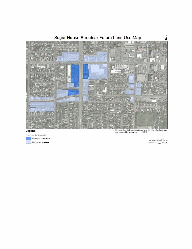
Community Transit District The Community Transit District supports the development of a localized urban center that
capitalizes on close proximity to the Sugar House Streetcar corridor and arterial streets.
Uses include a mix of residential, retail, commercial, and office with buildings oriented to
the pedestrian environment. Building height and density is concentrated along arterial
streets and is similar to the height, density, and design in the Sugar House Business District
which would create two active destinations linked by transit. While being a high density
area, development in the Community Transit District also respects and is compatible with
the surrounding residential neighborhoods. Future public improvements should be focused
on creating an interconnected and cohesive district that caters to all modes of
transportation including pedestrians and cyclists.
The following text was added to the Mobility, Access and the Pedestrian Experience section of the
plan:
Sugar House Streetcar and Greenway Corridor The Sugar House community has long envisioned the transformation of the Denver Rio Grande rail right‐of‐way into a public transit and multi‐use trail corridor. In 2012, this vision came to fruition as construction began on the Sugar House Streetcar and Greenway, a two mile long transit and active transportation corridor that connects the Sugar House Business District with the north‐south TRAX light rail line at 2100 South in South Salt Lake City. In 2011, the Redevelopment Agency of Salt Lake City funded an effort to create a vision for the streetcar corridor and surrounding area. This resulted in a set of recommendations put into a report titled Sugar House Streetcar Land Use and Urban Design Recommendations. As a result of this process, the City of Salt Lake City has funded improvements to transform the streetcar corridor into a greenway that includes dedicated multi‐use pathways and amenities.
Many of the recommendations stated in the Land Use and Urban Design Recommendations report that are related to the streetcar and greenway corridor itself have been implemented. There are
still improvements that should be considered in the future to activate the corridor, support existing neighborhoods, and create vibrant transit oriented districts near the streetcar stops. Policies
Work with Utah Transit Authority (UTA) to add a neighborhood serving streetcar stop near 800 East.
Where easements exist for automobile access within the corridor, the City should work with property owners to eliminate the easements. In the event of redevelopment of a property with an automobile access easement, all options must be explored to relocate and remove automobile access from the corridor.
Restore the original rail line right‐of‐way boundaries by removing existing encroachments (structures, fences, parking, etc.).
Streets that cross the corridor (500 East, 600 East, 700 East, 800 East, and 900 East) connect the corridor to adjacent neighborhoods; therefore, they should be developed as complete streets where feasible.
Development along the streetcar and greenway should encourage transit and trail usage, and provide eyes on the corridor. All buildings should have entrances from the corridor, windows along the corridor, and should minimize blank walls. Seating, dining areas, and active accessory functions should be encouraged.
Development should not overpower the corridor. Building heights should be sensitive to the open space characteristic of the corridor and allow sufficient sunlight.
Improve the public right‐of‐way near the streetcar stations to enhance pedestrian and bicycle circulation. Specific projects may include:
Widen the sidewalks within the Community Transit District and near the 500 East, 900 East, and McClelland streetcar stations to allow for a wider pedestrian thoroughfare, as well as additional space for furnishing and planting areas. One approach is to require additional front building setbacks with hardscaped front yard areas.
Analyze the feasibility of creating a beautification district within the Community Transit District to develop a program for the installation of and maintenance of street lighting, paving material, and landscaping with a common theme or pattern.
The Future Land Use Map in the Sugar House Master Plan was amended as part of Ordinance 23 of
2016. The modifications are shown on the map on the following page.