Embed Size (px)
Citation preview

SUGAR HOUSE LANE MASTERPLANNING EXERCISEAPRIL 2008
Sugar House Lane Masterplanning ExerciseAssessment of proposed conservation area

2 Sugar House Lane Masterplanning Exercise I Assessment of proposed conservation area I April 2008
This map is reproduced from Ordnance Survey material with the permission of Ordnance Survey on behalf of the Controller of Her Majesty’s Stationery Office.© Crown copyright. Unauthorised reproduction infringes Crown copyright and may lead to prosecution or civil proceedings. LTGDC 100044955/2006
Job reference: 726Plan reference: 726/01/01/001Date: February 2008Client: LTGDC
LEGEND MAP OF THE LOWER LEA VALLEY HERITAGE CONTEXT

3Sugar House Lane Masterplanning Exercise I Assessment of proposed conservation area I April 2008
1 Introduction
The Lower Lea Valley has a proud industrial past. From the eighteenth century onwards, hundreds of enterprises were crammed into the river corridor to support London’s economic growth. Much of the physical evidence has gone, but Sugar House Lane is a rare survivor of this former activity, with the remains of old works, warehouses and yards concentrated in a small triangle to the north of the Three Mills. There is nowhere else like it in Newham.
Parts of the area are neglected and vulnerable, but there are already signs of renewal and there is an opportunity to breathe new life into the old buildings and yards that survive at Sugar House Lane.
Through a combination of repairs, conversion and new build, the heritage of the area can be a powerful factor in the regeneration of Stratford and the Lower Lea.
This report celebrates the special historic and architectural interest of Sugar House Lane and proposes a conservation area to preserve and enhance its qualities.
2 Lower Lea Valley heritage context
Sugar House Lane has major historic significance in the context of the wider agenda for regeneration and renewal in the Lower Lea Valley and London Thames Gateway. These areas are a focus for new jobs and housing and the Olympics and Stratford City developments represent a major change in the character of both Stratford and the Lower Lea Valley.
The map on page 2 illustrates sites with heritage potential as outlined in the Lower Lea Valley Opportunity Area Planning Framework (2007).
Proposals for Stratford and the Olympics have led to a step-change in the speculative
Heritage assessment
Cobblestones bounded by cast iron band

4 Sugar House Lane Masterplanning Exercise I Assessment of proposed conservation area I April 2008
Cobblestones and cast iron accentsRoad detailing on Sugar House Lane
development interest in fringe Olympic sites and there is a concern that the cumulative impact of an unfettered market approach could erode the character of the area. It is important that proposals take into account the widespread loss of heritage in the Valley. It is critical that the remaining heritage assets are protected and enhanced and that new development highlights the defining spatial and built features of merit to ensure that the renewal of Sugar House Lane creates a distinctive location which has a sense of continuity with the past.
The Lower Lea Valley Opportunity Area Planning Framework (adopted by the Mayor of London in
January 2007) emphasises the importance of the character of the historic environment, encouraging sensitivity to unique local environments, including landscape character, environmental assets, and historic buildings and places. The OAPF states that “the valley as a whole has been shaped by a long history of industrial use and a unique role in London’s urban expansion. This has created a remarkably complex urban environment, which includes…a rich waterway environment and ecology, and diverse industrial areas”. Sugar House Lane is highlighted alongside Fish Island and Leamouth as an area of particular heritage character where existing character should be acknowledged and enhanced. (para 2.177).
The following extract from the Three Mills sub-area text identifies the importance of Sugar House Lane:
“In the northwest of the sub-area there is a group of 20th century industrial buildings on Sugar House Lane, which form an urban environment with significant historical character due to the variety of building types and sense of enclosure created, and could be considered for conservation area status as part of the historic Three Mills area.” (para 4.150)
This policy guidance is a key starting point in the context of the pressure for change, and it is of paramount importance that consideration is given to the study area’s historic environment.
Chimney no 1 is visible behind layers of industrial buildings

5Sugar House Lane Masterplanning Exercise I Assessment of proposed conservation area I April 2008
Role of local planning authorities
The London Borough of Newham has a duty to designate conservation areas and is the local planning authority with responsibility to determine planning applications. In addition, the Council is also responsible for planning policy guidance within the Local Development Framework which is currently under preparation.
Whilst the London Borough of Newham is the development control and planning policy making authority, London Thames Gateway Development Corporation has been responsible for determining all major planning applications and heritage/conservation applications.
Major applications are defined as those with over 50 residential units and those with over 2,500 sq m of commercial floor space.
The Olympic Delivery Authority (ODA) is the public body responsible for developing and building the new venues and infrastructure for the Games and their use post 2012. The ODA was established by the London Olympic Games and Paralympic Games Act, which received Royal Assent in March 2006. The Act was passed to ensure the necessary planning and preparation for the Games can take place and enables the ODA to take on functions of the local planning authority for The Olympic Park area. While Sugar House Lane is outside
this area, the ODA remains a key authority in the context of the Games.
Detail from industrial building on Sugar House LaneCobblestones revealed through the worn down tarmac

6 Sugar House Lane Masterplanning Exercise I Assessment of proposed conservation area I April 2008
The tallest of the three chimneys and a powerful landmark from every direction
“The Sugar House” seen from the east side of the Three Mills River
Sugar warehouse, Stratford High Street: an imposing and well preserved façade
Industrial detailing: steel windows, yellow stock brick with bullnose engineering brick cills
Granite setts, Sugar House Lane.There is extensive evidence of the original surfaces in the streets and yards Sugar House Yard
The wider heritage of the area is evident in the Three Mills complex, a picturesque survivor from the age of water-powered industry.
Twentieth century industry: 107-109 Stratford High Street
7Sugar House Lane Masterplanning Exercise I Assessment of proposed conservation area I April 2008
3. A Vision for Sugar House Lane
Sugar House Lane is an urban quarter in waiting. Unexplored and largely forgotten today, its fortunes could be transformed almost beyond recognition into a vibrant new destination in Newham, full of activity and colour, becoming a magnet for visitors. The industrial heritage of the area is the key to unlocking this potential.
The success of areas like Camden Lock and Southwark’s Borough Market demonstrate how the re-use of industrial buildings, particularly where they can be combined with an active waterfront or inspired new development, can create a cherished local resource and spur on the regeneration of a
wider area. Sugar House Lane has all the essential ingredients: a strong identity, robust yet adaptable old buildings, potentially enticing outdoor spaces and two stretches of waterfront. The area is well served by public transport and a transformed Sugar House Lane would be a natural partner to the bigger but more conventional attractions of Stratford town centre and the new Stratford City.
A strong character
This report has shown how the physical form of the Sugar House Lane area is the product of a burst of entrepreneurial activity during a short period, roughly 1850 to 1940. The combination of the imperatives of manufacturing with the particular topography of the
Lower Lee Valley has left the area with its own distinct personality, of a kind that is now rare in London and practically unique in Newham. The gritty functionality of the building groups and the informal spaces between them are the prime assets of the area, awaiting a new, post-industrial life.
Robust and adaptable old buildings
The old buildings in Sugar House Lane were not built for show and have little architectural refinement. Instead they are serviceable, unpretentious structures, built to withstand the demands of heavy loads, vibrating machinery, extreme fluctuations in temperature and the ravages of toxic

8 Sugar House Lane Masterplanning Exercise I Assessment of proposed conservation area I April 2008
or corrosive material. The buildings have been altered in places over the years, but for the most part they are stoutly constructed, with good headroom and plenty of daylight.
The old brickwork has developed an appealing patina and there are some interesting surviving details. However, all the buildings are capable of imaginative, even radical adaptation and extension without sacrificing the essence of their character or the evidence of their former purpose. The older buildings in Sugar House Lane and Three Mills have already demonstrated their suitability for small and medium sized businesses. Their flexible interiors and strong character
have made them particularly appropriate for the creative industries that could help to raise the profile of the area.
Contemporary infill
The more fragile or decayed buildings may be beyond repair and amongst the older stock there are some eyesores that should be removed. If the intensity of the area is to be recaptured, there will be a need for high quality new buildings to be woven into the historic fabric. This is a tremendous architectural opportunity, offering developers and architects the chance to take creative inspiration from the area’s history, whilst adopting new techniques and materials to forge a new spirit.
Yards and spaces
An intriguing web of passages, yards and roads are central to the distinctiveness of the area. There is scope to intensify these spaces, framing views of the Abbey Mills Pumping Station, the Bromley-by-Bow gasholders and, closer to hand, the three chimneys in and around Sugar House Lane. Apertures could be formed to give views of the rivers or access to their banks. Elsewhere there may be scope for containing some of the spaces with new buildings to create sunny, sheltered enclaves.
The interaction between the yards and the outdoor spaces could be enhanced through lively public uses – cafés, market stalls, performance
The tranquility of the Three Mills Wall River Gable end detail, Sugar House Lane
Blackwall Tunnel Approach Road: The Sugar House Lane chimneys are local landmarks Bromley-by-Bow gas holders; listed Grade II

9Sugar House Lane Masterplanning Exercise I Assessment of proposed conservation area I April 2008
spaces and public art displays. There might be a hierarchy of lesser, more private spaces and courtyards that would add variety to the pattern of development and provide tranquil corners for residents and workers.
A public lighting strategy would ensure that the Sugar House Lane area retained its appeal in the evening as a welcoming and secure place.
An appealing waterfront
The River Lee and the Three Mills Wall River are no longer the industrial open sewers they once were and commercial barges have not been seen on the Lee since the early 1980s. Leisure craft and wildlife habitats have taken their place and the towpaths are now
popular with walkers. There is a chance to establish a dynamic, positive interrelationship between the waterways and the buildings, possibly creating new inlets or moorings.
There are numerous survivals of granite kerbs and setts in Sugar House Lane
Sugar House Yard is an example of how the old yards can be colonised for new uses, including cultural industries
The bend on Sugar House Lane runs parallel to the former Three Mills Back River, close to the present-day Hunts Lane Dane’s Yard – an inviting enclave, full of potential for new activities

10 Sugar House Lane Masterplanning Exercise I Assessment of proposed conservation area I April 2008
Holbeck Urban Village (HUV) in Leeds provides an excellent example of the potential role of conservation and heritage in kick-starting successful and sustainable regeneration. The scheme has a number of parallels with Sugar House Lane, not least the juxtaposition of historic urban fabric with a dilapidated industrial environment.
The scheme involves the regeneration of one of the country’s oldest industrial areas and an expansion to Leeds city centre through the incorporation of a traditionally disconnected area of the city.
HUV covers an area of approximately 20 hectares separated from the city centre by a series of railway lines. The area is expected
Sensitive historical reference in the built forms, Holbeck, Leeds
Industrial references create exciting public spaces in Holbeck, Leeds
Existing potential has been enhanced in Holbeck, Leeds
Mixed use development in Holbeck, Leeds
11Sugar House Lane Masterplanning Exercise I Assessment of proposed conservation area I April 2008
to attract investment of up to £800 million and create approximately 5,000 jobs over the next ten years. The designated mixed-use area incorporates a six hectare Conservation Area and abuts a residential neighbourhood that has traditionally suffered from low quality of life levels and poor access to the city centre.
Within HUV, on the site of the first engineering works that kick-started the industrial revolution, the Round Foundry is a 1.5ha mixed use development that points the way for subsequent improvements within Holbeck. The four-acre complex includes 94 residential apartments, 52,000 sq ft office space, plus shops, bars and restaurants, all of which have been sympathetically designed around a series of
courtyards. The development has also become home to a contemporary art gallery and a new media centre, which have become a hub for creative media and internet businesses within Holbeck.
Developer CTP St. James commissioned Building Design Partnership (BDP) to design the scheme in 1999 and the architects ensured that a number of listed buildings within the site were sensitively restored and that new buildings complemented the historic structures. Construction work began in 2001 and was completed in 2004.
The layout of the existing and new buildings recreates the scale and character of the original streets on the site and encourages pedestrian traffic through it using a series of courtyards linked by
pedestrian routes. The original courtyards acted as service areas during the buildings’ period of industrial use and the transformation of these into attractive public spaces is testament to the high quality and considered design throughout the scheme.
Buildings are planned for the canal side, and to the west of the canal, the Italianate towers of the listed works will provide legibility for a series of plazas leading out from the city centre.
SOURCE: CABE neighbourhood and regeneration case-studies researched by Urban Practitioners www.cabe.org.uk(All images on these pages from cabe.org.uk)
CASE-STUDY Heritage-led regeneration
12 Sugar House Lane Masterplanning Exercise I Assessment of proposed conservation area I April 2008
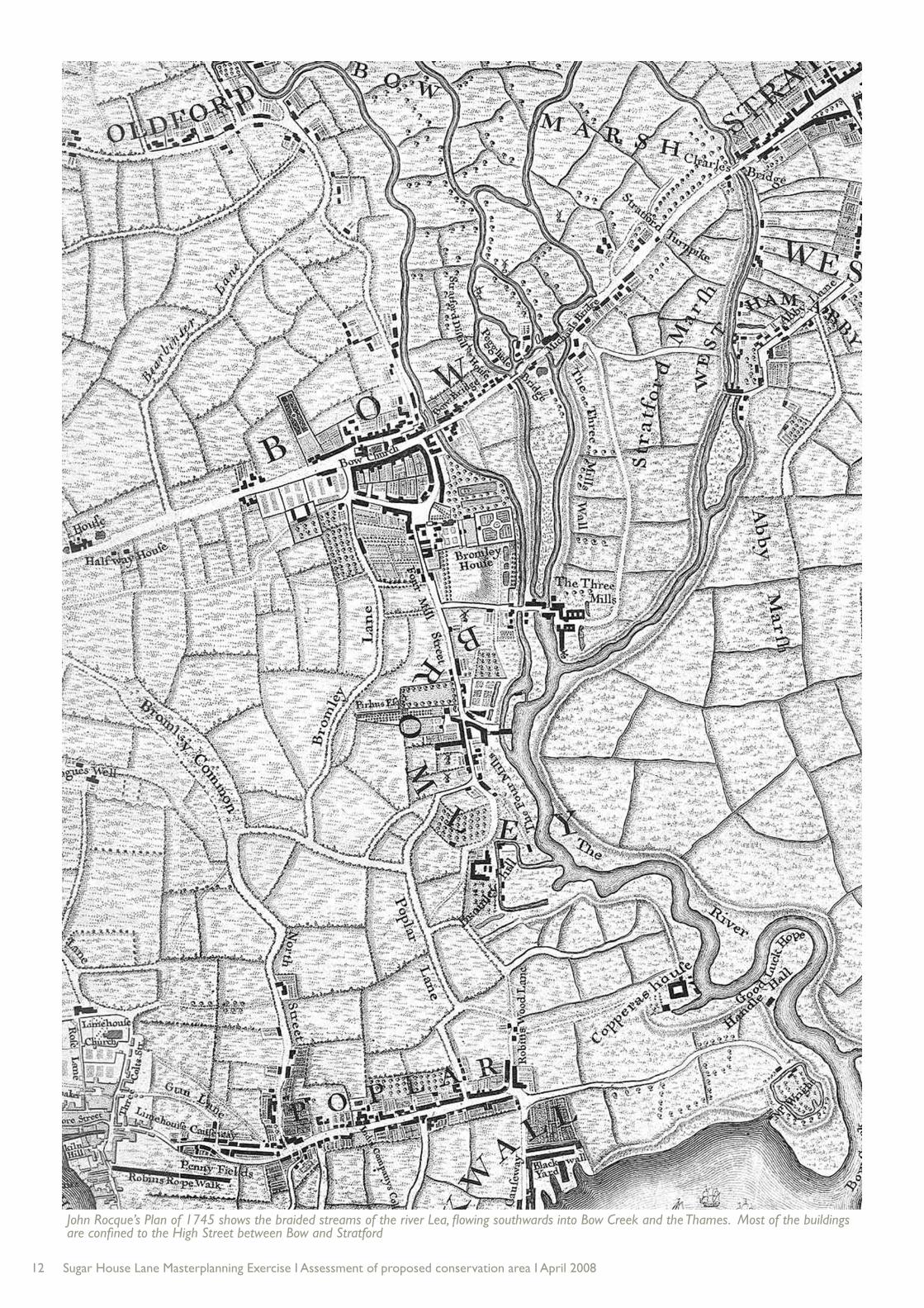
John Rocque’s Plan of 1745 shows the braided streams of the river Lea, flowing southwards into Bow Creek and the Thames. Most of the buildings are confined to the High Street between Bow and Stratford

13Sugar House Lane Masterplanning Exercise I Assessment of proposed conservation area I April 2008
4 Historic developmentThe marshes of the Lea Valley were straddled by an ancient highway, now the High Street, after the building of Bow Bridge in 1110. Further north the old Roman Road, from Colchester to London crossed the Lea at Old Ford.
John Rocque’s map of 1745 is a vital document showing the pre-industrial Lea Valley before it became densely occupied with factories and houses. Some of the fields around Stratford were under cultivation, but the low-lying Lea valley was mostly marshland and pasture on the flood plain. The serpentine form of the River Lea (or Lee) was fed by numerous meandering creeks and streams to the north, which in the
Middle Ages had supported the Cistercian abbey of Stratford Langthorne. Rocque shows a scatter of buildings on the north side of the High Street, leading up to Bow Bridge. The Three Mills Back River is clearly shown, running through the middle of the triangle formed by the Lea and Three Mills Wall River. The River Lea Act 1766 authorised extensive improvement works to the Lea, formalising it as a canalised river though extensive improvement works including locks, new sections of waterway and above all, the construction of the Limehouse Cut, a straight section linking the Lee Navigation at Bromley-by-Bow to the Thames at Limehouse.
Chapman and André’s map (1777) shows windmills on Bow Marsh, north of the High Street. Clayton (1821) outlines a dock to the south of the High Street, reached from the Lea by a short channel. This was West Ham’s earliest proper dock and may have been built by the Middlesex and Essex Turnpike Trust, which owned and occupied the site in 1843 and 1854. It was initially known as Stratford Dock, but later became Meggs Dock, possibly named after local ladder-maker John Meggs. The dock was filled in at the turn of the 20th century when it became known as Mill River Wharf.
Ordnance Survey map from 1867 - the southern half of Sugar House Lane has yet to be developed

14 Sugar House Lane Masterplanning Exercise I Assessment of proposed conservation area I April 2008
From the middle of the eighteenth century onwards, London began its sustained growth and transformation into the world’s first metropolis. The River Lea was the boundary between Middlesex and Essex and the Essex side became a convenient location for heavy industry and manufacturing, whose noisy, fume-ridden and often dangerous works could not be accommodated within the city. The abundant water supply was important for many processes and the navigable waterways, which together with the profusion of railway lines and railheads after 1840 ensured the ready transport of goods and materials.
In 1867, the First Series Ordnance Survey map of the
area was published and it provides a valuable detailed record of the Sugar House Lane area. Narrow fingers of development extend on both sides of the High Street and numerous factories and works are shown, including copper, lime, chemical, tar, emery, starch, ammonia, cork carpet and match production. The map also records the area’s long associations with the printing and ink industries. To the west of the Lea on the Middlesex side were Lloyd’s Paper Mills, next to St Mary’s Church. The northern part of Sugar House Lane at the junction with the High Street is shown, although it is not named on the map.
The southern half of the triangle between the Three Mills Back River and the Three
Mills Wall River is shown as two unbuilt parcels of land. By 1895 the picture had changed again. Sugar House Lane is now at its full extent, reaching to the confluence of the Back and Wall rivers and providing a spine for more works, often packed in tightly around the river Wharfs.
In the 1930s the area underwent a major change. In 1930 Parliament passed the River Lea Act, to improve drainage and navigation in the area. The Prescott Channel was subsequently constructed to serve as a flood bypass, from Three Mills Wall River to the Channelsea River. To the west of Sugar House Lane the Three Mills Back River was filled in, and the southern section was paved over to
The first dye manufacturer • in West Ham appears to have been Harry Hodson & Co of Sugar House Lane, which was active from c.1862 to 1939
Sugar House Lane is • thought to take its name from the sugar refinery that stood on the south side of the High Street, immediately west of Three Mills River, from the first half of the 19th century
19th CENTURY INDUSTRIES IN SUGAR HOUSE LANE
Ordnance Survey map from 1894

15Sugar House Lane Masterplanning Exercise I Assessment of proposed conservation area I April 2008
Ordnance Survey map from 1916
form Hunts Lane. Shortly after this date a number of light industrial buildings were built on Stratford High Street, taking advantage of ready access into and out of central London.
The docks and factories of east London were a prime target for aerial bombardment during the Second World War and parts of West and East Ham were badly hit. Many homes and businesses were destroyed or severely damaged through enemy action, resulting in extensive post-war reconstruction. Six high explosive and incendiary bombs fell on Sugar House Lane in 1940 and 1941, one of the casualties being the Usher Walker printing ink works which had opened in 1892, but otherwise the area escaped
relatively unscathed. After the war the area continued its role as a place of manufacturing, with transport uses on the High Street and warehouses squeezed in and around the various factories and Nicholsons Distillery at the southern end of Sugar House Lane. Any remaining land was used for vehicle manoeuvring or open storage. The present Bow Bridge was built in 1967 by the Greater London Council as part of a flyover and link to the Blackwall Tunnel approach road. The Ordnance Survey plan of 1969 shows Sugar House Lane at its most intensively developed, with the triangle between Stratford, Three Mills Wall River and the Lea crammed with factories and warehouses including, at the south end of Hunts
Lane, the ‘Invicta Industrial Estate’. Amongst the industries present are two printing works, representing a continuity of trade of over a hundred years.
Traffic in commercial barges on the Lee Navigation ended in the early 1980s, leaving the waterfront as a quiet backwater.
Kelly’s Directory of 1900 • records 17 companies in Sugar House Lane itself, of which six were ink manufacturers; others were machinery makers, concrete block manufacturers, timber merchants, ultramarine makers, timber merchants, asphalt makers, brickmakers and a horse slaughterer
Principal Sources: Victoria County History - Essex (1973)Newham Local History Collection

16 Sugar House Lane Masterplanning Exercise I Assessment of proposed conservation area I April 2008
This map is reproduced from Ordnance Survey material with the permission of Ordnance Survey on behalf of the Controller of Her Majesty’s Stationery Office.© Crown copyright. Unauthorised reproduction infringes Crown copyright and may lead to prosecution or civil proceedings. LTGDC 100044955/2006
Job reference: 726Plan reference: 726/01/01/002Date: February 2008Client: LTGDC
LEGEND MAP OF VIEWS TO AND FROM SUGAR HOUSE LANE

17Sugar House Lane Masterplanning Exercise I Assessment of proposed conservation area I April 2008
5 Sugar House Lane today
Distinctive spatial qualities
The Sugar House Lane area is roughly heartshaped and is bounded by the River Lea, the Three Mills Wall River and Stratford High Street.
The High Street is a heavily trafficked and somewhat hostile environment, but the almost continuous wall of buildings on the south side absorbs much of the noise and Sugar House Lane itself is surprisingly tranquil. The overriding character of the area is that of a practical, no nonsense place. The highly informal layout reflects the piecemeal growth of the area in the nineteenth century,
with buildings jammed opportunistically into gap sites and corners. The buildings themselves are functional and unadorned, mostly with simple rectangular footprints but often occupying irregular plots conditioned by the position of the water courses.
The height and scale of the buildings varies considerably; from one to five storeys, and from small cellular buildings to deep plan modern industrial sheds.
Doorways are commonly set back from the road and reached from delivery yards. The variety in building heights allows the chimneys and taller buildings to be glimpsed over the rooftops, contributing to the legibility of the place.
There is sparse vegetation in the area but the waterways exert a strong character and there are important long views into and out of the study area. The towers of Canary Wharf can clearly be seen from Sugar House Lane.
This map is reproduced from Ordnance Survey material with the permission of Ordnance Survey on behalf of the Controller of Her Majesty’s Stationery Office.© Crown copyright. Unauthorised reproduction infringes Crown copyright and may lead to prosecution or civil proceedings. LTGDC 100044955/2006
A J
D
CL
B1
B2
B3
F
E
EK
I
AM
H GMap of identified spaces and buildings of merit

18 Sugar House Lane Masterplanning Exercise I Assessment of proposed conservation area I April 2008
6 Analysis of key buildings and spaces
This section provides a review of the key buildings and spaces in the study area and demonstrates their historic value in the context of the designation of a new Conservation Area.
Buildings of townscape importance
For the most part the older survivors are simple industrial structures, built between 1880 and 1930 to accommodate a range of industries. They are collectively important as physical reminders of London’s manufacturing heyday, but they also have group value and contribute to the
distinctiveness of the area. Building materials are those common to Victorian industrial London namely yellow stock bricks with slate roofs and evidence of timber sashes or cast iron, fixed light windows. Later buildings, including the chimneys, are in red brick, with the most recent being in machine-made buff brick and lightweight steel truss roofs.
B3
B1
B2
B Chimney locations C Location of the “Sugar House”A 133 - 135 Stratford High Street
A
C
A Warehouse at 133 - 135 Stratford High Street seen from the towpath on Three Mills Wall River

19Sugar House Lane Masterplanning Exercise I Assessment of proposed conservation area I April 2008
A photograph and location plan is provided for each building and space referred to below.
A 133 - 135 Stratford High Street
This is the best preserved industrial building in the Sugar House Lane area. The building has group value with others on the Three Mills Wall River.
The building dates from the latter part of the 19th or early 20th century. It was almost certainly a warehouse rather than a factory and it may have been part of the former sugar refinery that is believed to have stood on the site. The building is four storeys, including an attic storey.
The building has three bays by nine, London stock brick
with metal (possibly cast iron) windows in segmental openings with segmental lintels triple banded with yellow brick headers. There are modern flues and downpipes. The roof is gabled on the High Street, and is hipped to the rear. The roof covering was presumably slate originally, but is now sheet covering (corrugated asbestos or steel). Loading doors are situated in the rear (S) elevation to provide access to the wharf.
The High Street façade is in yellow brick with red brick window arches with keystones. The ground floor openings have been altered and modern signs introduced, but the original windows survive above.
D Location of 7 Sugar House Lane
D
E Location of the Sugar House Yard buildings
E
B Chimney no 3B Chimney no 2B Chimney no 1

20 Sugar House Lane Masterplanning Exercise I Assessment of proposed conservation area I April 2008
There is an oculus window in the gable to serve the attic space.
B Chimneys
The three chimneys are simple, functional structures but each is slightly different in height, profile and silhouette so they form important markers on the skyline. Their purpose is unknown, but at one time the
area would have been studded with chimneys to provide boilerhouse updrafts and the escape of noxious fumes. Coal was the universal fuel. All are thought to date from the late nineteenth or early 20th century. The chimneys are important to the legibility and understanding of the site, being visible from numerous vantage points, including the Blackwall
Tunnel approach, Tesco and the Pudding Mill Lane DLR station.
The three chimneys can be described as follows:
“Chimney No 1” red •
engineering brick with a simple cylindrical shaft, the most conspicuous and the tallest of the three chimneys.
“Chimney No 2” red brick •
with a square plan, plain
F Location of 107 and 109 Stratford High St
F
G Location of Building at 3 Mills StudiosG
H Location of Riverbank HouseH
C Warehouse behind Sugar House Lane, the “Sugar House”
D Dane building at 7 Sugar House Lane
E The Sugar House Yard buildings

21Sugar House Lane Masterplanning Exercise I Assessment of proposed conservation area I April 2008
G Building at 3 Mills Studios, Sugar House LaneF 107 and 109 Stratford High Street
shaft. Reinforced with metal banding. Its original function is unknown.
“Chimney No 3” is located •
to the rear of 119 High Street and is within the yard of CW Plant Hire. It is constructed in red brick on a square section, with a corbelled brick cap.
C Warehouse behind Sugar House Lane (“The Sugar House”)
The height of the building with its asymmetrical gables makes it a prominent landmark, seen from the platform of the Pudding Lane DLR station. With Chimney No 1, this building is one of the two leading landmarks in the area and it forms part of a group with other buildings
on the Three Mills Wall River waterfront. The 1896 Ordnance Survey map shows it being on the site of a former cooperage.
The building was built in the late 19th century as a warehouse, and is six storeys high (including attic) with a double ridged roof, five by five bays (one roof stretching over three bays). The finish is red brick with strong vertical accents through the buttresses, which emphasise its industrial function. There are modern sash windows replacements and a remodelled ground floor on the north side. The building is now converted into separate business units.
The adjoining office block that faces the river dates to the early twentieth century,
probably from the inter-war period. The main architectural feature is the first storey Diocletian window, with some art deco embellishment in the surrounding brickwork.
D 7 Sugar House Lane (Dane Group building)
Built around 1900, 7 Sugar House Lane is solidly constructed in London stock brick and occupies a prominent position on the bend of the road. It is six bays wide, including a double height loading bay, with small pane steel windows on the ground floor. The upper windows are modern replacements.

22 Sugar House Lane Masterplanning Exercise I Assessment of proposed conservation area I April 2008
E Sugar House Yard buildings
A tight-knit group of buildings off Sugar House Lane, two and three storeys in height, built with red brick with characteristic industrial detailing, such as the bullnose engineering bricks which are used for the window cills.
F 107 and 109 Stratford High Street
Post-war industrial offices and works, with lightweight steel framed curtain wall construction and prominent horizontal glazing. The big fascias with oversized lettering were designed to draw the attention of passing motorists. Once common on all the main roads into London, such buildings are becoming rare.
Whilst these buildings are of interest, they are not considered to be of sufficient merit to identify them as ‘buildings of note’ in the proposed Conservation Area.
G Building at 3 Mills Studios, Sugar House Lane
This two-storey stock brick building is characterised by broad casement windows with modern replacements of possible tripartite sashes and a modern sheet metal roof. The wide entrance has been altered, but the building retains its late nineteenth century character. It was possibly a small works but is now part of the 3 Mills Studios complex.
H Riverbank House, Sugar House Lane
Riverbank House has a symmetrical red brick facade of seven bays with the central three being narrower and projecting slightly. The building has original steel windows beneath flat soldier course lintels and has an artificial stone steeped entrance surround. Riverbank House (c.1930) was probably used originally as offices or for light manufacturing. The fascia above entrance reads “Towler & Son Ltd, Established 1892”.
H Riverbank House - Interwar factory, now within the 3 Mills Studios complex
23Sugar House Lane Masterplanning Exercise I Assessment of proposed conservation area I April 2008
J Location of the Dane Yard
J
I Location of the Three Mills Back River Yard
I
Listed buildings outside the study area, but visible from Sugar House Lane
Abbey Mills Pumping Station, built in 1868 and listed Grade ll*, is one of London’s most flamboyant industrial structures and of great historical interest in association with the construction of the Northern Outfall Sewer. It is also an important landmark,
visible across Sugar House Lane from the yard to the rear of 113-119 High Street.
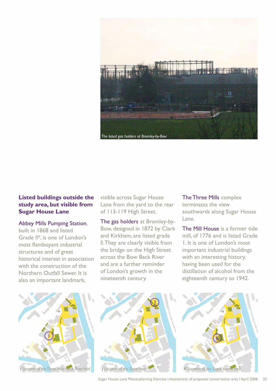
The gas holders at Bromley-by-Bow, designed in 1872 by Clark and Kirkham, are listed grade ll. They are clearly visible from the bridge on the High Street across the Bow Back River and are a further reminder of London’s growth in the nineteenth century.
The Three Mills complex terminates the view southwards along Sugar House Lane.
The Mill House is a former tide mill, of 1776 and is listed Grade 1. It is one of London’s most important industrial buildings with an interesting history, having been used for the distillation of alcohol from the eighteenth century to 1942.
K Location of the Sugar House Yard
K
The listed gas holders at Bromley-by-Bow

24 Sugar House Lane Masterplanning Exercise I Assessment of proposed conservation area I April 2008
K ‘Cooperage Yard’ with chimney no 3 in the background
J Dane Yard
I Three Mills Back River Yard

25Sugar House Lane Masterplanning Exercise I Assessment of proposed conservation area I April 2008
Key spaces
The intimate sequence of yards are a vital part of the character of Sugar House Lane. The yard spaces play a strong role in defining place identity at the study area. The following yards and spaces are of particular significance:
I Three Mills Back River Yard is typical of the area; a composite space of linked yards.
J Dane Yard is irregularly shaped by the old buildings around it and is partly paved in granite setts. It allows a glimpse through to the old wharf on the Three Mills Wall River.
K The current Sugar House Yard has an interesting flow of spaces and chimney No 2 closes the view along one of the passages at one point,
reinforcing its former industrial character.
L ‘Cooperage Yard’ to the east of Sugar House Lane is contained by a stock brick wall and some of the granite setts survive. Its layout is substantially that shown on the 1894 Ordnance Survey map.
M Meggs Dock has long been filled in, but part of the space remains and with
it something of the history of this remarkable area. It was constructed in 1821 as Stratford Dock and its site is of interest as being one of the main operational assets in the former industrial landscape. The plan below illustrates the extent of Meggs Dock as shown in the 1867 Ordnance Survey map.
M The former Meggs Dock seen from across the River LeaL Sugar House Yard
M Location of the Meggs Dock Yard
M
L
L Location of the ‘Cooperage Yard’

26 Sugar House Lane Masterplanning Exercise I Assessment of proposed conservation area I April 2008
‘The Sugar House’ a former riverside warehouse and the principal landmark in the area. Now successfully converted to small business units
Square granite setts, imported for their exceptional strength and durability
Three Mills Wall River: The Bromley by Bow gas holders can be seen in the distance
Warehouse end wall, with segmental arch windows and gable oculus (now infilled): characteristic industrial detailing
Three Mills Wall River: Strong regeneration potential133-135 Stratford High Street
The asymmetrical gables of the ‘Sugar House’ make the building a distinctive landmark on the skyline Waterfront panorama, Three Mills Wall River

27Sugar House Lane Masterplanning Exercise I Assessment of proposed conservation area I April 2008
7. The conservation areaA conservation area is an area of “special architectural or historic interest, the character or appearance of which it is desirable to preserve or enhance”. Conservation areas are designated locally and every local authority has a duty to identify those parts of its area that meet the legal description.
Since 1967, when the Civic Amenities Act came into effect, more than 9,000 conservation areas have been designated in England. Local authorities are expected to carry out a character appraisal and it is also customary for there to be public consultation before a conservation area is designated. Consent from
the local planning authority is required for substantial works of demolition and six weeks’ notice must be given before any works are done to a tree in a conservation area.
Conservation areas are not simply about controlling development; there is a firm expectation that they will be enhanced through public and private investment, in buildings and in the public realm. There are numerous precedents for designating industrial areas as conservation areas and using the heritage of the area as a catalyst for change. Amongst the best known are Ancoats in Manchester, Kelham Island in Sheffield, Bradford’s Little Germany, Holbeck in Leeds, Nottingham’s Lace Market and the Jewellry Quarter
in Birmingham. In London, Butler’s Wharf, Rotherhithe and Brentford Dock provide instructive examples.
The recognition of the historic environment in Sugar House Lane will be used to reinforce local distinctiveness and to inspire a high standard of design.
The advantages of designating Sugar House Lane as a conservation area are as follows:
Formal recognition of the •
intrinsic interest of the area within the context of the Lower Lea Valley;
A demonstration of •
Newham Council’s commitment to conservation led regeneration;

28 Sugar House Lane Masterplanning Exercise I Assessment of proposed conservation area I April 2008
This map is reproduced from Ordnance Survey material with the
permission of Ordnance Survey on behalf of the Controller of Her
Majesty’s Stationery Office.
© Crown copyright. Unauthorised reproduction infringes Crown
copyright and may lead to prosecution or civil proceedings. LTGDC
100044955/2006
Map of identified spaces and buildings of merit and proposed conservation area boundary
This map is reproduced from Ordnance Survey material with the permission of Ordnance Survey on behalf of the Controller of Her Majesty’s Stationery Office.© Crown copyright. Unauthorised reproduction infringes Crown copyright and may lead to prosecution or civil proceedings. LTGDC 100044955/2006
Job reference: 726Plan reference: 726/01/003Date: February 2008Client: LTGDC
LEGEND PROPOSED SUGAR HOUSE LANE CONSERVATION AREA - CORE BOUNDARY

29Sugar House Lane Masterplanning Exercise I Assessment of proposed conservation area I April 2008
This map is reproduced from Ordnance Survey material with the
permission of Ordnance Survey on behalf of the Controller of Her
Majesty’s Stationery Office.
© Crown copyright. Unauthorised reproduction infringes Crown
copyright and may lead to prosecution or civil proceedings. LTGDC
100044955/2006
Map of identified spaces and buildings of merit and proposed conservation area boundary
This map is reproduced from Ordnance Survey material with the permission of Ordnance Survey on behalf of the Controller of Her Majesty’s Stationery Office.© Crown copyright. Unauthorised reproduction infringes Crown copyright and may lead to prosecution or civil proceedings. LTGDC 100044955/2006
Job reference: 726Plan reference: 726/01/004Date: February 2008Client: LTGDC
LEGEND PROPOSED SUGAR HOUSE LANE CONSERVATION AREA - OPTION FOR EXTENDED BOUNDARY

30 Sugar House Lane Masterplanning Exercise I Assessment of proposed conservation area I April 2008
A safeguard against •
demolition of locally significant buildings;
Help in marketing the area •
as a historically significant enclave; and
Conservation area status •
will help to promote a higher standard of development control.
The special interest of the area
Sugar House Lane is of demonstrable special interest due to the following reasons:
It has long historical •
associations with particular industries, especially sugar refining, printing ink manufacture, chemicals, building trades;
Sugar House Lane provides •
exceptional evidence of nineteenth century industry in the Lower Lea Valley;
The intimate sequence of •
spaces and waterways;
The plain, simple buildings •
but strong group value;
The rich silhouette and •
skyline; and
The palette of traditional •
materials including granite setts, red and London stock brickwork.
The watercourses are also a vital part of the site’s special interest. Historically water power was the main source of energy for the early mills, which acted as a catalyst for future industrial development.
The river also provided clean water for textile production and laying out grounds for calico, which supported the development of ancillary uses, including printing and dye works. Ordinances preventing the slaughter of cattle within a certain distance of London encouraged the growth of noxious industries at Sugar House Lane, including tanning and leather working. The rivers were navigable and as such enabled water borne commerce.
Today, the rivers continue to play a strong role in defining the character of the area and allowing long views in and out. The water contributes to the setting and character of both the buildings and activities in the study area. The rivers also

31Sugar House Lane Masterplanning Exercise I Assessment of proposed conservation area I April 2008
provide natural and ecological value.
The proposed boundary
The proposed Sugar House Lane conservation area concentrates on the northern part of the triangle. This is the best preserved area, with a concentration of yards and surviving older buildings within a late Victorian industrial enclave.
The proposed boundary plans (see pages 28 and 29) illustrate a proposed core boundary and an option for an extended boundary.
The proposed core boundary is defined to the north by Stratford High Street to the north and to the east, by the Three Mills Wall River. The
western boundary takes in the older, top half of Hunts Lane and includes the prominent chimney on its western side.
The core boundary includes all the buildings highlighted in this report as being of individual note or group value, apart from Riverbank House and the building at 3 Mills Studio.
The site of the former Meggs Dock, of the River Lea, is noted for its historical associations but it is not considered necessary to include it within the conservation area boundary.
As set out above, the rivers play an important role in defining the setting and special character of the area and it is important that the relationship between the site and the river
is enhanced with suitable links, views, scale, design and uses.
A further option for consideration by the London Borough of Newham is an extension of the boundary to the south.
The extended boundary reaches across the threshold of the 3 Mills Studios to include two buildings of note: the red brick, interwar building known as Riverbank House, and an older stock brick building, probably nineteenth century, of domestic scale that may have been associated with Nicholsons’ Distillery.

32 Sugar House Lane Masterplanning Exercise I Assessment of proposed conservation area I April 2008
Swans on the Three Mills Wall River: clean water courses have helped to restore the wildlife and ecology in this formerly polluted area
Three Mills Back River from Stratford High Street, with a view south towards the listed gas holders at Bromley-by-Bow
Granite kerbs and setts, Sugar House Lane
Sugar House Yard: one of three landmark chimneys Cast iron manhole cover, Sugar House Lane
Sugar House Yard is an example of how the old yards can be colonised for new uses, including cultural industries Yellow stock brick yard wall, following the curve of Sugar House Lane
Three Mills Wall River, looking towards Sugar House Lane from the eastern towpath. Canary Wharf can be seen in the distance

33Sugar House Lane Masterplanning Exercise I Assessment of proposed conservation area I April 2008
8 . Recommendations
The recommendation is a single, coherent core conservation area as illustrated on page 28. No spot listing of buildings is required or recommended at this stage.
A further option for consideration by the London Borough of Newham is an extension of the boundary to the south to include Riverbank House and the building at 3 Mills Studios (see page 29).
The designation of the Conservation Area will be complemented by the Sugar House Lane Masterplan which is currently being prepared by a consultant team on behalf of London Thames Gateway Development Corporation.
The Masterplan will provide a wider context for a proactive Conservation Area enhancement strategy including design guidance, land use strategy and public realm and landscaping improvements. The Masterplan will also have a role to play in informing guidance for Sugar House Lane in appropriate documents within the Newham Local Development Framework.

34 Sugar House Lane Masterplanning Exercise I Assessment of proposed conservation area I April 2008
70 Cowcross StreetLondonEC1M 6EJ
Telephone 020 7253 2223Fax 020 7253 2227Email [email protected]


![Great House Indoril [MasterPlanning] v1.0](https://img.pdfslide.us/doc/110x75/577c842a1a28abe054b7c2eb/great-house-indoril-masterplanning-v10.jpg)