Embed Size (px)
Citation preview
SUBSECTION 8.4
Land Use

8.4 Land Use 8.4.1 Introduction This section provides an inventory of existing and planned land uses in the vicinity of the proposed San Francisco Electric Reliability Project (SFERP) facilities. For purposes of this analysis, the affected environment (study area) is defined as those areas within one mile of the proposed SFERP site and within 0.25 mile of the proposed offsite linear facilities. The overview of the project’s affected environment includes a description of existing land uses and zoning districts in the project study area. An analysis of the potential impacts on land uses surrounding the proposed project is provided. This section also evaluates the project’s consistency with land use plans and policies, including adopted local, regional, state, and federal plans applicable to the proposed project.
Land use trends identified for the study area are based on current land use plans and approved development projects. Reasonably foreseeable future development projects are assessed for potential cumulative land use impacts. Where appropriate, mitigation measures are proposed to reduce potential project-related land use impacts to acceptable levels.
Land use impacts associated with the proposed SFERP are identified and evaluated based on:
•
•
•
•
•
•
•
Site reconnaissance surveys
A review of current U.S. Geological Survey (USGS) 7.5-minute topographic (i.e., quadrangle) maps
Aerial photography
A review of local land use ordinances
A review of the land use goals and policies identified in the San Francisco General Plan (General Plan) and associated Area Plans and maps
Future land use development trends
Discussions with City planners
Other local plans reviewed for this assessment include plans adopted by the Bay Conservation and Development Commission (BCDC), the Port of San Francisco, and the Metropolitan Transportation Commission (MTC).
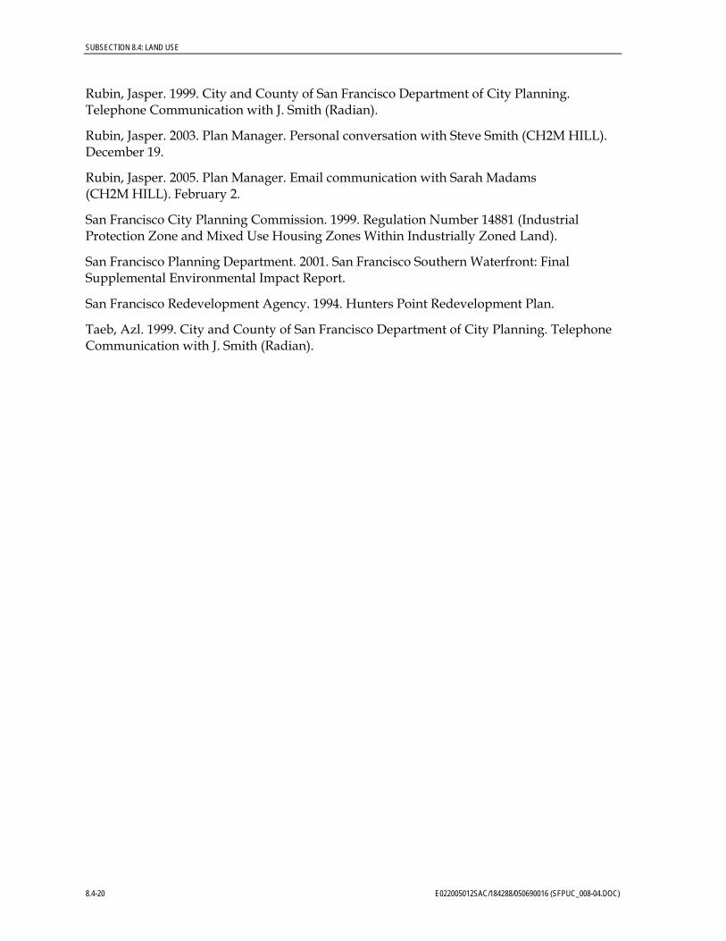
8.4.2 Affected Environment The affected environment of the project is defined in accordance with the requirements of the California Energy Commission (CEC). The affected land use environment/study area includes, but is not limited to, the area within a one-mile radius of the proposed SFERP facilities and one-quarter mile surrounding the proposed offsite facilities. The one-mile radius surrounding the SFERP site encompasses the 0.25-mile area surrounding all proposed linear facilities. Government agencies with land use jurisdiction in the study area include the City, the San Francisco Redevelopment Agency, BCDC, and the Port of
E022005012SAC/184288/050690016 (SFPUC_008-04.DOC) 8.4-1
SUBSECTION 8.4: LAND USE
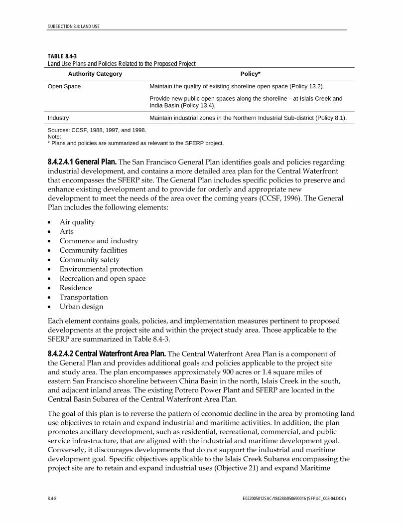
San Francisco. Figure 8.4-1 shows jurisdictional boundaries within the project study area. (Figures are located at the end of this subsection.)
8.4.2.1 Regional Setting San Francisco County is one of nine counties that comprise the San Francisco Bay Area. The City and County of San Francisco (CCSF) are contiguous jurisdictions encompassing an area approximately 8 miles across from east to west and 5 to 7 miles across from north to south. Surrounding counties include Marin to the north, Alameda to the east, and San Mateo to the south. The Pacific Ocean and San Francisco Bay bound San Francisco to the north, east, and west. Most of San Francisco is heavily urbanized, with small pockets of open-space areas preserved as parks.
The project is situated within Potrero Point along the eastern shoreline of the San Francisco Bay between Central Basin in the north and Islais Creek Channel in the south. This area is referred to as the Central Waterfront and is dominated by industrial land uses. Residential and commercial uses are located farther west of the industrial band of land uses along the waterfront. The existing Potrero Power Plant is located approximately 0.3 mile north of the SFERP site. SBC Park is located approximately 1.8 miles north of the SFERP site, and the Hunters Point Power Plant is approximately 1.7 miles to the south.
8.4.2.2 Existing Land Uses and Zoning The proposed SFERP site encompasses approximately 4 acres owned by the City of San Francisco. The project site does not include any permanent structures. However, a temporary concrete batch plant occupies the northern portion of the project site. The area immediately east of the project site, within the proposed staging area, is currently used as trailer storage for a trucking operation.
The project site is surrounded by industrial land uses. These include a cement facility directly north of the site, various industrial land uses along Cesar Chavez Street south of the site, and shipping facilities east of the site along the waterfront of the San Francisco Bay. The land directly west of the project site is currently vacant. However, the San Francisco Municipal Railway (MUNI) is planning to construct a light-rail maintenance-and-operations facility at this site.
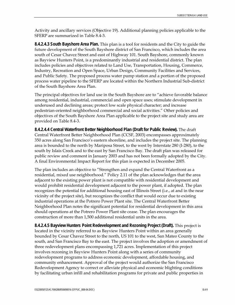
As shown on Figure 8.4-2, the majority of land uses within the one-mile study area are industrial. Within 1,500 feet north, south, and west of the project site, existing development is predominantly industrial. Land uses east of the project site include the San Francisco Bay and shipping facilities along the waterfront. Islais Creek is located approximately 1,000 feet south of the project site. The Potrero Power Plant and electrical substation are located approximately 0.3 mile north of the SFERP site at 23rd Street and Illinois Street. Typical land use in the vicinity of the SFERP site includes shipping piers and dry dock facilities, vehicle storage and impoundment yards, gas stations, warehouses, factories, small commercial businesses, a railroad yard, and trucking companies.
Nonindustrial land uses are mainly located at the outer portions of the study area. Residential, retail/commercial, and public land uses (e.g., parks/open space and institutional uses such as schools, churches and libraries) are located at least 0.25 mile from the project site, with the exception of Warm Water Cove park located 705 feet north of the
8.4-2 E022005012SAC/184288/050690016 (SFPUC_008-04.DOC)
SUBSECTION 8.4: LAND USE
project site, and a church on Cesar Chavez Street located 474 feet south. Various worker lofts are located throughout the study area, including the nearby vicinity of the project site. The nearest dwelling units are located approximately 1,600 feet west of the project site near Minnesota Street and 25th Street. There are no agricultural land uses within the affected environment.
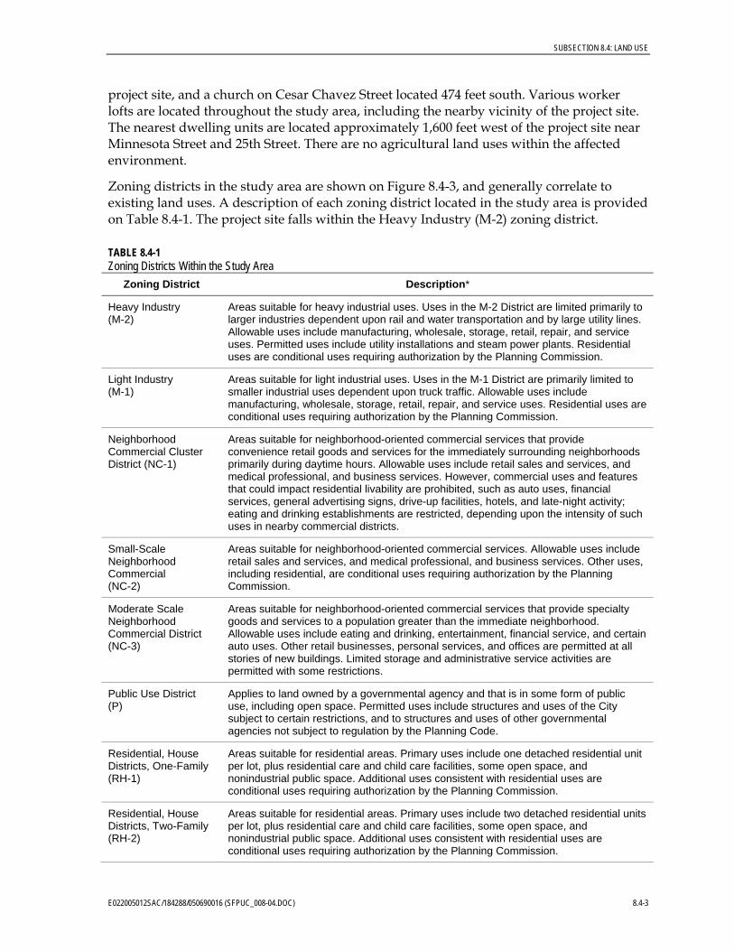
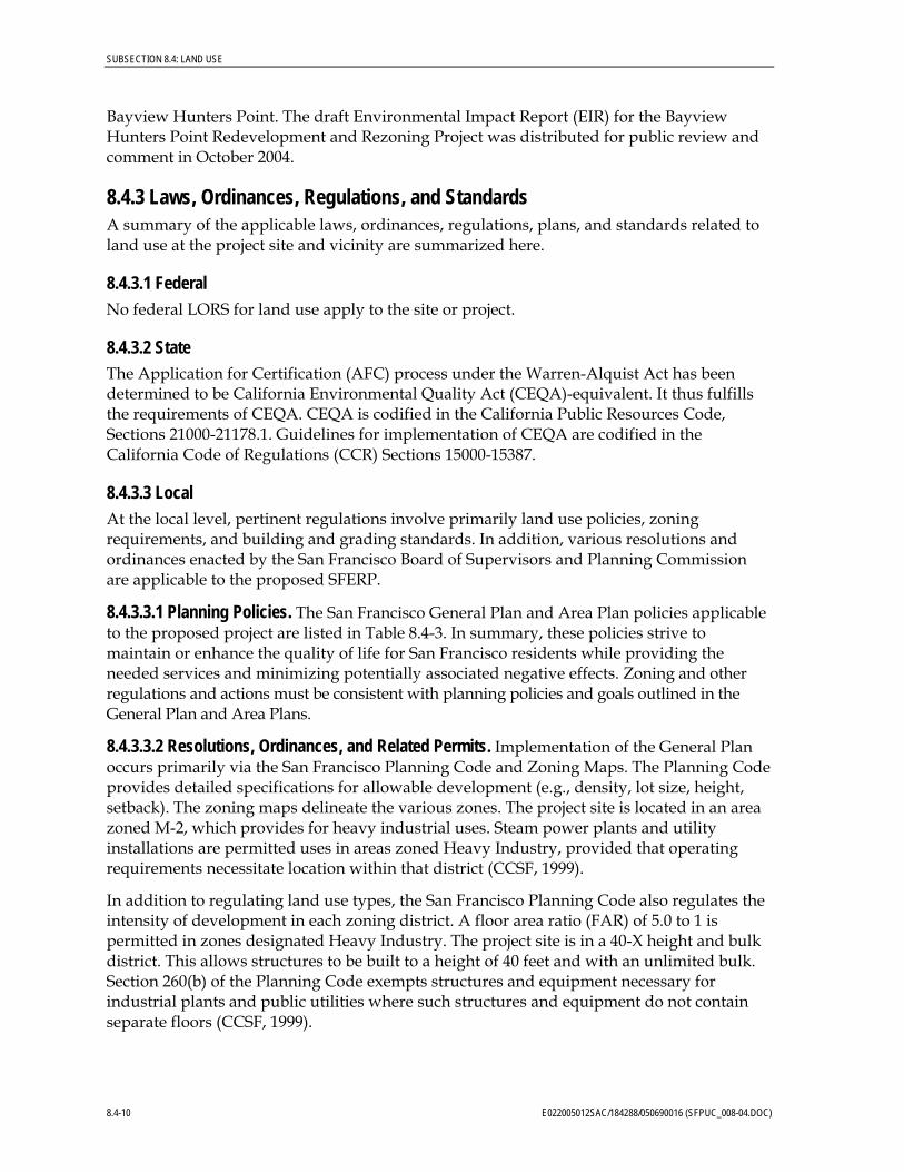
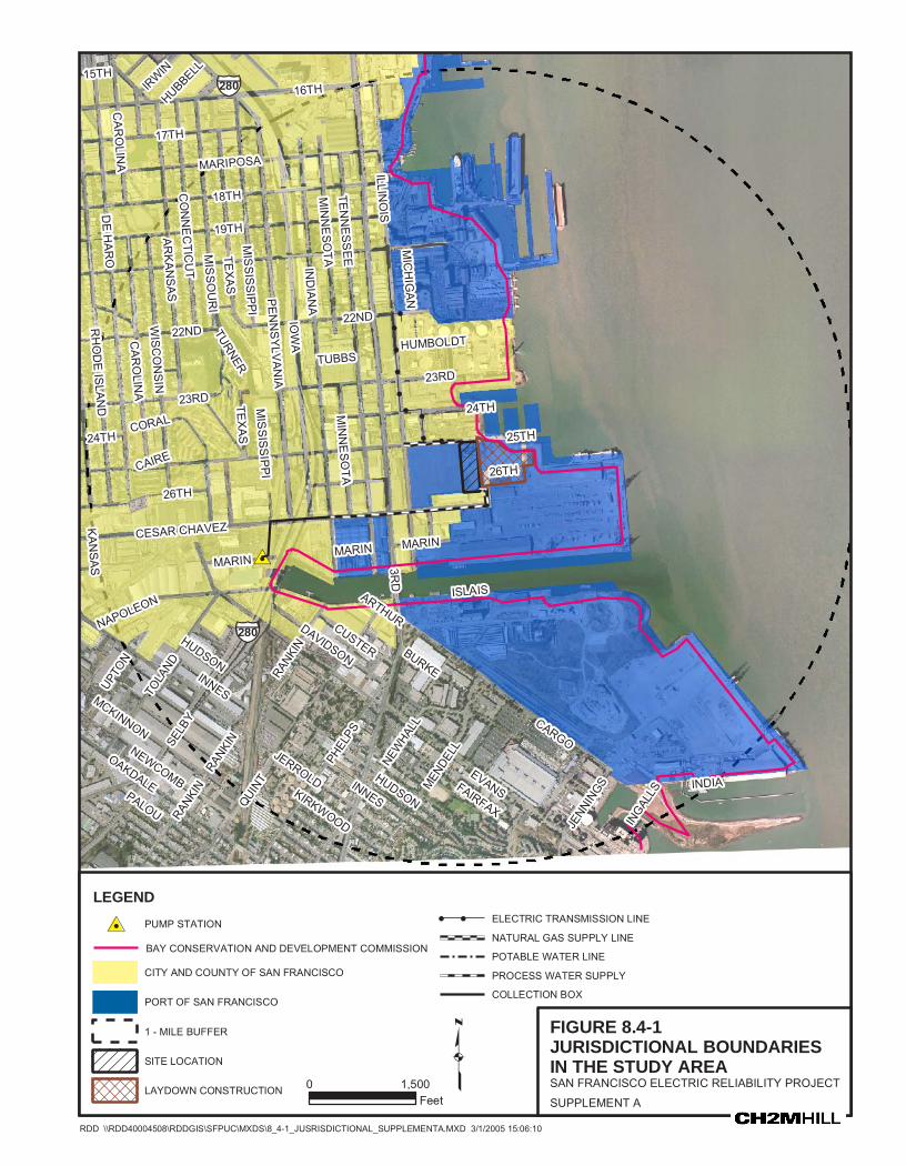
Zoning districts in the study area are shown on Figure 8.4-3, and generally correlate to existing land uses. A description of each zoning district located in the study area is provided on Table 8.4-1. The project site falls within the Heavy Industry (M-2) zoning district.
TABLE 8.4-1 Zoning Districts Within the Study Area
Zoning District Description*
Heavy Industry (M-2)
Areas suitable for heavy industrial uses. Uses in the M-2 District are limited primarily to larger industries dependent upon rail and water transportation and by large utility lines. Allowable uses include manufacturing, wholesale, storage, retail, repair, and service uses. Permitted uses include utility installations and steam power plants. Residential uses are conditional uses requiring authorization by the Planning Commission.
Light Industry (M-1)
Areas suitable for light industrial uses. Uses in the M-1 District are primarily limited to smaller industrial uses dependent upon truck traffic. Allowable uses include manufacturing, wholesale, storage, retail, repair, and service uses. Residential uses are conditional uses requiring authorization by the Planning Commission.
Neighborhood Commercial Cluster District (NC-1)
Areas suitable for neighborhood-oriented commercial services that provide convenience retail goods and services for the immediately surrounding neighborhoods primarily during daytime hours. Allowable uses include retail sales and services, and medical professional, and business services. However, commercial uses and features that could impact residential livability are prohibited, such as auto uses, financial services, general advertising signs, drive-up facilities, hotels, and late-night activity; eating and drinking establishments are restricted, depending upon the intensity of such uses in nearby commercial districts.
Small-Scale Neighborhood Commercial (NC-2)
Areas suitable for neighborhood-oriented commercial services. Allowable uses include retail sales and services, and medical professional, and business services. Other uses, including residential, are conditional uses requiring authorization by the Planning Commission.
Moderate Scale Neighborhood Commercial District (NC-3)
Areas suitable for neighborhood-oriented commercial services that provide specialty goods and services to a population greater than the immediate neighborhood. Allowable uses include eating and drinking, entertainment, financial service, and certain auto uses. Other retail businesses, personal services, and offices are permitted at all stories of new buildings. Limited storage and administrative service activities are permitted with some restrictions.
Public Use District (P)
Applies to land owned by a governmental agency and that is in some form of public use, including open space. Permitted uses include structures and uses of the City subject to certain restrictions, and to structures and uses of other governmental agencies not subject to regulation by the Planning Code.
Residential, House Districts, One-Family (RH-1)
Areas suitable for residential areas. Primary uses include one detached residential unit per lot, plus residential care and child care facilities, some open space, and nonindustrial public space. Additional uses consistent with residential uses are conditional uses requiring authorization by the Planning Commission.
Residential, House Districts, Two-Family (RH-2)
Areas suitable for residential areas. Primary uses include two detached residential units per lot, plus residential care and child care facilities, some open space, and nonindustrial public space. Additional uses consistent with residential uses are conditional uses requiring authorization by the Planning Commission.
E022005012SAC/184288/050690016 (SFPUC_008-04.DOC) 8.4-3
SUBSECTION 8.4: LAND USE
TABLE 8.4-1 Zoning Districts Within the Study Area
Zoning District Description*
Residential, House Districts, Three-Family (RH-3)
Areas suitable for residential areas. Primary uses include three detached residential units per lot, plus residential care and child care facilities, some open space, and nonindustrial public space. Additional uses consistent with residential uses are conditional uses requiring authorization by the Planning Commission.
Residential, Mixed Districts, Low Density (RM-1)
Areas suitable for residential areas. Primary uses include one detached residential unit per lot, and a significant number of apartment buildings. Shopping facilities and transit lines may be found within a short distance of these districts. Nonresidential uses are often present to provide for the needs of residents. Additional uses consistent with residential uses are conditional uses requiring authorization by the Planning Commission.
Residential, Mixed Districts, Moderate Density (RM-2)
These districts are generally similar to RM-1 Districts, but the overall density of units is greater and the mixture of building types and unit sizes is more pronounced. Where nonresidential uses are present, they tend to offer services for wider areas than in RM-1 Districts.
Source: CCSF, 1999. * Reference to “compatible” uses within the descriptions is based on the zoning requirements.
Planned land uses in the near vicinity of the project site are limited to the M-2 zoning district. As noted above, this district allows for a variety heavy industrial uses, including steam power plants and utility installations. As noted in Table 8.4-1, residential development is a conditional use within both M-1 and M-2 zoning districts, requiring approval from the City Planning Commission.
Recent development within the study area includes 63 housing units located primarily west of Third Street and north of the project site. In addition, a significant commercial structure was recently completed at Cesar Chavez Street and Third Street (Rubin, 2003).
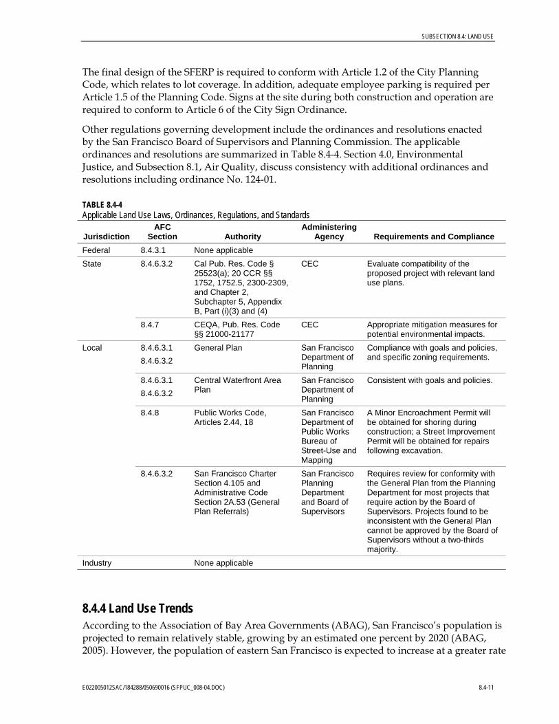
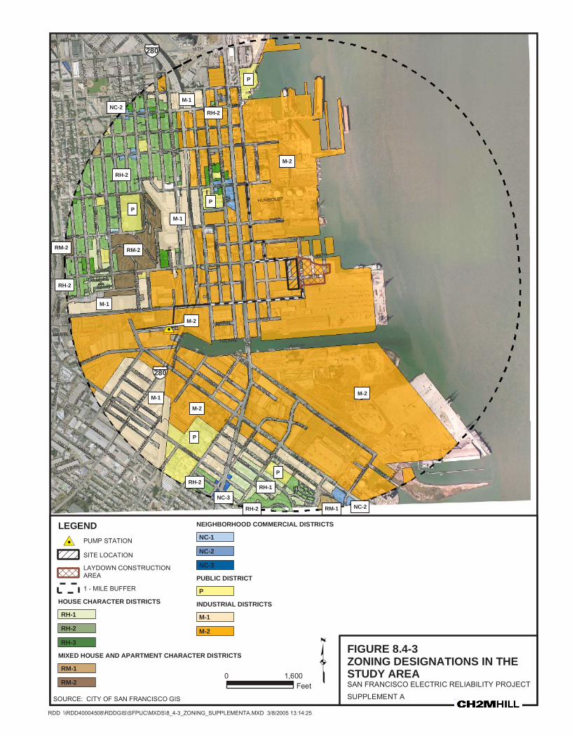
8.4.2.3 Potentially Sensitive Land Uses Potentially sensitive land uses in the study area include schools, parks, churches, libraries, and residences. These uses are mapped on Figure 8.4-4 and listed on Table 8.4-2. Residential uses are shown on Figure 8.4-2. Additional sensitive land uses within a 3-mile radius from the project site are described in Section 8.6, Public Health and Section 8.12, Hazardous Materials.
The nearest sensitive land use is a church located 474 feet southwest of the project site on Cesar Chavez Street near Michigan Street. The closest dwelling units to the project site are located approximately 1,600 feet west of the project site near Minnesota Street and 25th Street. The nearest recreational use is Warm Water Cove, located approximately 705 feet north of the project site. As summarized on Table 8.4-2, non-residential sensitive land uses in the SFERP study area include 9 schools, 11 churches, 6 parks, 3 senior centers, and one library.
8.4-4 E022005012SAC/184288/050690016 (SFPUC_008-04.DOC)
SUBSECTION 8.4: LAND USE
TABLE 8.4-2 Potentially Sensitive Land Uses within the Affected Area
Land UseaApproximate Distance from
Proposed Project Siteb
CHURCH
1 – Bayview Tabernacle Baptist Church 5,084 feet
2 – Bethel Temple United Holy Church 5,133 feet
3 – First Russian Christian Moloka 4,911 feet
4 – House of God in San Francisco 5,262 feet
5 – New Beginning Church of God 5,080 feet
6 – Pathfinders Mission Baptist Church 4,288 feet
7 – St. James Baptist Church 4,461 feet
8 – St. John Missionary Baptist 4,457 feet
9 – St. Stephen Baptist Church 2,364 feet
10 – St. Teresa’s Church 4,720 feet
11 – Supreme Master Ching Hai International 474 feet
LIBRARY
12 – Potrero Branch Library 4,624 feet
PARKS
13 – Youngblood Coleman Playground 4,596 feet
14 – Islais Creek Public Access Area 1,721 feet
15 – Heron’s Head Park 4,959 feet
16 – Warm Water Cove Public Access Area 705 feet
17 – Esprit Park 3,620 feet
18 – Potrero Hill Playground 4,228 feet
SCHOOLS/DAYCARE
19 – Angel Childcare for Infants 4,247 feet
20 – Cleo Wallace Child Growth Center 3,528 feet
21 – Daniel Webster Elementary School 4,630 feet
22 – Karen’s Family Day Care 4,615 feet
23 – Rise Institute 3,023 feet
24 – San Francisco City College 3,321 feet
25 – San Francisco Head Start 4,946 feet
26 – Applied Science and Technology School 3,702 feet
27 – Starr King Elementary School 2,844 feet
E022005012SAC/184288/050690016 (SFPUC_008-04.DOC) 8.4-5
SUBSECTION 8.4: LAND USE
TABLE 8.4-2 Potentially Sensitive Land Uses within the Affected Area
Land UseaApproximate Distance from
Proposed Project Siteb
SENIOR CENTERS
28 – Bayview Hunters Point Senior Center 2,230 feet
29 – Network for Elders 3,435 feet
30 – Mission Bay Convalescent Hospital 4,649 feet
Notes: a Does not include residential land uses (refer to Figure 8.4-2). b The affected environment consists of the area within one mile (1,760 yards) of the generating plant site and within
a quarter-mile (440 yards) of linear facilities.
Sensitive land uses can also include cultural and historical sites as well as natural scenic areas. See Subsection 8.3, Cultural Resources and Subsection 8.11, Visual Resources for assessments of these environmental areas.
8.4.2.4 Land Use Plans and Policies The project site is located within the City of San Francisco. Land use plans adopted by San Francisco and applicable to the proposed project include the General Plan, the Central Waterfront Area Plan, a component of the General Plan, and the South Bayshore Area Plan. The Central Waterfront Better Neighborhood Plan, a separate plan developed for the Central Waterfront Area, encompasses approximately 500 acres and includes the SFERP project site. A draft of this plan was distributed for public review in January 2003, but has not been adopted by the City. South of the SFERP site, planning for the Bayview Hunters Point Redevelopment and Rezoning Project is in progress, which includes three redevelopment project areas totaling 1,721 acres. Linear SFERP features extend into the planning area of this project.
The following plans do not directly apply to the project site, but apply to land uses within the project study area:
• • •
Port of San Francisco Waterfront Land Use Plan, Waterfront Design and Access Element San Francisco Bay Plan (by BCDC) San Francisco Bay Area Seaport Plan (by MTC and BCDC)
Land use plans applicable to the proposed SFERP are discussed in the sections that follow. Specific goals, policies, or objectives applicable to the SFERP are discussed under Subsection 8.4.3 (Laws, Ordinance, Regulations, and Standards) and summarized in Table 8.4-3.
8.4-6 E022005012SAC/184288/050690016 (SFPUC_008-04.DOC)
SUBSECTION 8.4: LAND USE
TABLE 8.4-3 Land Use Plans and Policies Related to the Proposed Project
Authority Category Policy*
San Francisco General Plan Commerce and Industry, Environmental Protection, Urban Design, and Air Quality Elements
Environmental Protection Assure that all new development meets strict environmental quality standards and recognizes human needs.
Promote the use and development of shoreline areas consistent with the Comprehensive Plan and the best interest of San Francisco.
Comply with objectives, policies, and air quality standards of the Bay Area Air Quality Management District.
Growth Encourage development that provides substantial net benefits and minimizes undesirable consequences.
Locate commercial and industrial activities according to a generalized Commercial and Industrial Density Plan map.
Open Space Assure that new development adjacent to the shoreline capitalizes on its unique waterfront location, considers shoreline land use provisions, improves visual and physical access to the water, and conforms with urban design policies.
Urban Design Promote harmony on the visual relationships and transitions between new and older buildings.
Relate the bulk of buildings to the prevailing scale of development to avoid an overwhelming or dominating appearance in new construction.
Community Safety Assure that new construction meets current structural and life safety standards.
Consider information about geologic hazards whenever City decisions that will influence land use, building density, building configurations, or infrastructure are made.
Central Waterfront Area Plan
Land Use Encourage the intensification and expansion of industrial uses (Policy 1).
Prevent the conversion of land needed for industrial activity to nonindustrial use (Policy 2).
Assure that the adverse environmental impacts of new development are fully mitigated (Policy 3).
Industry Promote industrial expansion through maximizing and intensifying the use of existing facilities and properties (Policy 1).
Islais Creek Subarea Retain and expand industrial uses in the Islais Creek Area (Objective 21).
Expand Maritime Activity and ancillary services (Objective 19).
South Bayshore Area Plan
Land Use Restrict industrial activities with significant environmental hazards from locating adjacent to or nearby existing residential areas (Policy 1.2).
Encourage a wider variety of light industrial uses in South Basin by more efficient use of industrial space (Policy 1.5).
E022005012SAC/184288/050690016 (SFPUC_008-04.DOC) 8.4-7
SUBSECTION 8.4: LAND USE
TABLE 8.4-3 Land Use Plans and Policies Related to the Proposed Project
Authority Category Policy*
Open Space Maintain the quality of existing shoreline open space (Policy 13.2).
Provide new public open spaces along the shoreline—at Islais Creek and India Basin (Policy 13.4).
Industry Maintain industrial zones in the Northern Industrial Sub-district (Policy 8.1).
Sources: CCSF, 1988, 1997, and 1998. Note: * Plans and policies are summarized as relevant to the SFERP project.
8.4.2.4.1 General Plan. The San Francisco General Plan identifies goals and policies regarding industrial development, and contains a more detailed area plan for the Central Waterfront that encompasses the SFERP site. The General Plan includes specific policies to preserve and enhance existing development and to provide for orderly and appropriate new development to meet the needs of the area over the coming years (CCSF, 1996). The General Plan includes the following elements:
• • • • • • • • • •
Air quality Arts Commerce and industry Community facilities Community safety Environmental protection Recreation and open space Residence Transportation Urban design
Each element contains goals, policies, and implementation measures pertinent to proposed developments at the project site and within the project study area. Those applicable to the SFERP are summarized in Table 8.4-3.
8.4.2.4.2 Central Waterfront Area Plan. The Central Waterfront Area Plan is a component of the General Plan and provides additional goals and policies applicable to the project site and study area. The plan encompasses approximately 900 acres or 1.4 square miles of eastern San Francisco shoreline between China Basin in the north, Islais Creek in the south, and adjacent inland areas. The existing Potrero Power Plant and SFERP are located in the Central Basin Subarea of the Central Waterfront Area Plan.
The goal of this plan is to reverse the pattern of economic decline in the area by promoting land use objectives to retain and expand industrial and maritime activities. In addition, the plan promotes ancillary development, such as residential, recreational, commercial, and public service infrastructure, that are aligned with the industrial and maritime development goal. Conversely, it discourages developments that do not support the industrial and maritime development goal. Specific objectives applicable to the Islais Creek Subarea encompassing the project site are to retain and expand industrial uses (Objective 21) and expand Maritime
8.4-8 E022005012SAC/184288/050690016 (SFPUC_008-04.DOC)
SUBSECTION 8.4: LAND USE
Activity and ancillary services (Objective 19). Additional planning policies applicable to the SFERP are summarized in Table 8.4-3.
8.4.2.4.3 South Bayshore Area Plan. This plan is a tool for residents and the City to guide the future development of the South Bayshore district of San Francisco, which includes the area south of Cesar Chavez Street and east of Highway 101. South Bayshore, commonly known as Bayview Hunters Point, is a predominantly industrial and residential district. The plan includes policies and objectives related to Land Use, Transportation, Housing, Commerce, Industry, Recreation and Open Space, Urban Design, Community Facilities and Services, and Public Safety. The proposed process water pump station and a portion of the proposed process water pipeline to the SFERP are located within the Northern Industrial Sub-district of the South Bayshore Area Plan.
The principal objectives for land use in the South Bayshore are to “achieve favorable balance among residential, industrial, commercial and open space uses; stimulate development in underused and declining areas; protect low scale physical character; and increase pedestrian-oriented neighborhood commercial and social activities.” Other policies and objectives of the South Bayshore Area Plan applicable to the project site and study area are provided on Table 8.4-3.
8.4.2.4.4 Central Waterfront Better Neighborhood Plan (Draft for Public Review). The draft Central Waterfront Better Neighborhood Plan (CCSF, 2003) encompasses approximately 350 acres along San Francisco’s eastern shoreline, and includes the project site. The planning area is bounded to the north by Mariposa Street, to the west by Interstate 280 (I-280), to the south by Islais Creek and to the east by San Francisco Bay. The draft plan was released for public review and comment in January 2003 and has not been formally adopted by the City. A final Environmental Impact Report for this plan is expected in December 2005.
The plan includes an objective to “Strengthen and expand the Central Waterfront as a residential, mixed use neighborhood.” Policy 2.11 of the plan acknowledges that the area adjacent to the existing power plant is not compatible with residential development and would prohibit residential development adjacent to the power plant, if adopted. The plan recognizes the potential for additional housing east of Illinois Street (i.e., at and in the near vicinity of the project site), but recognizes the conflict that would occur due to existing industrial operations at the Potrero Power Plant site. The Central Waterfront Better Neighborhood Plan notes the significant potential for residential development in this area should operations at the Potrero Power Plant site cease. The plan encourages the construction of more than 1,500 additional residential units in the area.
8.4.2.4.5 Bayview Hunters Point Redevelopment and Rezoning Project (Draft). This project is located in the vicinity referred to as Bayview Hunters Point within an area generally bounded by Cesar Chavez Street to the north, US 101 to the west, San Mateo County to the south, and San Francisco Bay to the east. The project involves the adoption or amendment of three redevelopment plans encompassing 1,721 acres. Implementation of this project involves rezoning in Bayview Hunters Point along with a series of community redevelopment programs to address economic development, affordable housing, and community enhancement. Approval of the project would authorize the San Francisco Redevelopment Agency to correct or alleviate physical and economic blighting conditions by facilitating urban infill and rehabilitation programs for private and public properties in
E022005012SAC/184288/050690016 (SFPUC_008-04.DOC) 8.4-9
SUBSECTION 8.4: LAND USE
Bayview Hunters Point. The draft Environmental Impact Report (EIR) for the Bayview Hunters Point Redevelopment and Rezoning Project was distributed for public review and comment in October 2004.
8.4.3 Laws, Ordinances, Regulations, and Standards A summary of the applicable laws, ordinances, regulations, plans, and standards related to land use at the project site and vicinity are summarized here.
8.4.3.1 Federal No federal LORS for land use apply to the site or project.
8.4.3.2 State The Application for Certification (AFC) process under the Warren-Alquist Act has been determined to be California Environmental Quality Act (CEQA)-equivalent. It thus fulfills the requirements of CEQA. CEQA is codified in the California Public Resources Code, Sections 21000-21178.1. Guidelines for implementation of CEQA are codified in the California Code of Regulations (CCR) Sections 15000-15387.
8.4.3.3 Local At the local level, pertinent regulations involve primarily land use policies, zoning requirements, and building and grading standards. In addition, various resolutions and ordinances enacted by the San Francisco Board of Supervisors and Planning Commission are applicable to the proposed SFERP.
8.4.3.3.1 Planning Policies. The San Francisco General Plan and Area Plan policies applicable to the proposed project are listed in Table 8.4-3. In summary, these policies strive to maintain or enhance the quality of life for San Francisco residents while providing the needed services and minimizing potentially associated negative effects. Zoning and other regulations and actions must be consistent with planning policies and goals outlined in the General Plan and Area Plans.
8.4.3.3.2 Resolutions, Ordinances, and Related Permits. Implementation of the General Plan occurs primarily via the San Francisco Planning Code and Zoning Maps. The Planning Code provides detailed specifications for allowable development (e.g., density, lot size, height, setback). The zoning maps delineate the various zones. The project site is located in an area zoned M-2, which provides for heavy industrial uses. Steam power plants and utility installations are permitted uses in areas zoned Heavy Industry, provided that operating requirements necessitate location within that district (CCSF, 1999).
In addition to regulating land use types, the San Francisco Planning Code also regulates the intensity of development in each zoning district. A floor area ratio (FAR) of 5.0 to 1 is permitted in zones designated Heavy Industry. The project site is in a 40-X height and bulk district. This allows structures to be built to a height of 40 feet and with an unlimited bulk. Section 260(b) of the Planning Code exempts structures and equipment necessary for industrial plants and public utilities where such structures and equipment do not contain separate floors (CCSF, 1999).
8.4-10 E022005012SAC/184288/050690016 (SFPUC_008-04.DOC)
SUBSECTION 8.4: LAND USE
The final design of the SFERP is required to conform with Article 1.2 of the City Planning Code, which relates to lot coverage. In addition, adequate employee parking is required per Article 1.5 of the Planning Code. Signs at the site during both construction and operation are required to conform to Article 6 of the City Sign Ordinance.
Other regulations governing development include the ordinances and resolutions enacted by the San Francisco Board of Supervisors and Planning Commission. The applicable ordinances and resolutions are summarized in Table 8.4-4. Section 4.0, Environmental Justice, and Subsection 8.1, Air Quality, discuss consistency with additional ordinances and resolutions including ordinance No. 124-01.
TABLE 8.4-4 Applicable Land Use Laws, Ordinances, Regulations, and Standards
Jurisdiction AFC
Section Authority Administering
Agency Requirements and Compliance Federal 8.4.3.1 None applicable
8.4.6.3.2 Cal Pub. Res. Code § 25523(a); 20 CCR §§ 1752, 1752.5, 2300-2309, and Chapter 2, Subchapter 5, Appendix B, Part (i)(3) and (4)
CEC Evaluate compatibility of the proposed project with relevant land use plans.
State
8.4.7 CEQA, Pub. Res. Code §§ 21000-21177
CEC Appropriate mitigation measures for potential environmental impacts.
Local 8.4.6.3.1 8.4.6.3.2
General Plan San Francisco Department of Planning
Compliance with goals and policies, and specific zoning requirements.
8.4.6.3.1 8.4.6.3.2
Central Waterfront Area Plan
San Francisco Department of Planning
Consistent with goals and policies.
8.4.8 Public Works Code, Articles 2.44, 18
San Francisco Department of Public Works Bureau of Street-Use and Mapping
A Minor Encroachment Permit will be obtained for shoring during construction; a Street Improvement Permit will be obtained for repairs following excavation.
8.4.6.3.2 San Francisco Charter Section 4.105 and Administrative Code Section 2A.53 (General Plan Referrals)
San Francisco Planning Department and Board of Supervisors
Requires review for conformity with the General Plan from the Planning Department for most projects that require action by the Board of Supervisors. Projects found to be inconsistent with the General Plan cannot be approved by the Board of Supervisors without a two-thirds majority.
Industry None applicable
8.4.4 Land Use Trends According to the Association of Bay Area Governments (ABAG), San Francisco’s population is projected to remain relatively stable, growing by an estimated one percent by 2020 (ABAG, 2005). However, the population of eastern San Francisco is expected to increase at a greater rate
E022005012SAC/184288/050690016 (SFPUC_008-04.DOC) 8.4-11
SUBSECTION 8.4: LAND USE
during this period due to availability of additional housing units anticipated in the Mission Bay and Hunters Point Redevelopment areas (Lee, 2000). Adoption of the Central Waterfront Neighborhood Plan would result in the development of approximately 1,500 dwelling units in the study area. South of the SFERP study area, the draft Bayview Hunters Point Redevelopment and Rezoning Project plans for a net increase of 3,700 dwelling units. Additional planned development in eastern San Francisco includes the Rincon Point/South Beach Redevelopment project. This redevelopment projects is located north of the SFERP study area.
On March 2, 2004, the citizens of San Francisco rejected a ballot initiative (Proposition J) that would have (1) allowed for the construction of up to 10,000 residential units in downtown San Francisco and the Central Waterfront area and (2) required the San Francisco Planning Department to ensure that there is sufficient land for at least 5,000 additional housing units in the Central Waterfront area. Although Proposition J was defeated, it is evidence of significant interest by some policy makers to facilitate additional affordable residential housing in the City with a particular focus on the Central Waterfront area.
8.4.5 Recent Discretionary Reviews Based on communication with the San Francisco Planning staff (Rubin, 2005), applications for 398 housing units have been recently approved or are pending approval. Figure 8.4-5 shows those housing units within the study area. In addition, applications for various commercial projects comprising several hundred thousand square feet of new development are also pending or have been approved by the City.
North of the project site, new development is planned at Pier 70 by the Port of San Francisco. The goal of this plan is to rehabilitate and adaptively use the existing historic buildings onsite. The Port intends to provide public-oriented uses at Pier 70, anchored by an institutional tenant such as a government agency or nonprofit organization (Paez, 2004).
South of the project site, the Port has several projects planned or under construction (Beaupre, 2005).
• A multi-modal bridge over Islais Creek will commence construction in March 2005. Construction will last for 18 months. The bridge will link Illinois Street in the north and Cargo Way in the south, and will provide access for rail, truck traffic, and bicyclists.
• Two concrete/cement batch plants are being constructed south of Islais Creek on Pier 92 and 94. Both plants are expected to be operational by summer 2005.
• The Pier 90-94 Backlands is a 44-acre site in the initial planning phase for a distribution and warehouse complex. Upon successful completion of planning and feasibility studies, the Port plans to issue a development RFP to invite development proposals for the site.
8.4.6 Environmental Consequences This section discusses the environmental consequences of the proposed SFERP related to land use impacts within the project study area. The potential environmental consequences concern both the construction and the operation of the power plant and associated linear facilities.
8.4-12 E022005012SAC/184288/050690016 (SFPUC_008-04.DOC)
SUBSECTION 8.4: LAND USE
8.4.6.1 Significance Criteria Significance criteria for impacts to land use were determined through review of applicable State and local regulations. Because the Warren-Alquist Act is equivalent to a CEQA review, the following criteria developed from the CEQA Guidelines and the CEQA Checklist were used to evaluate the potential environmental impacts of the project:
•
•
•
•
•
Will the project physically divide an established community?
Will the project conflict with any applicable land use plan, policy, or regulation of an agency with jurisdiction over the project (including, but not limited to, the general plan, specific plan, local coastal program, or zoning ordinance) adopted for the purpose of avoiding or mitigating an environmental effect?
Will the project conflict with any applicable habitat conservation plan or natural community conservation plan?
Will the project result in noise and odor nuisances that will cause existing land uses to cease or be adversely affected, or inhibit the development of future planned land uses?
Will the project generate traffic problems that will restrict access, adversely affecting land uses?
8.4.6.2 Construction Impacts Prior to construction, temporary concrete batch plant facilities currently located onsite would be relocated. In addition, the truck trailers stored at the laydown area would also be moved. Due to the portability and temporary nature of these operations, this is not considered a significant land use impact.
Construction of the SFERP will occur adjacent to industrial land uses. Due to the nature of operations at these uses and associated environmental conditions (e.g., high noise and traffic levels), no impact to nearby or adjacent land uses is expected to result from construction activities.
Construction activities would result in noise, dust, equipment exhaust emissions, and other nuisances that could affect sensitive land uses in the study area. However, the distance between the project site and the most sensitive land uses in the study area would provide a sufficient buffer such that existing activities at these uses would not be interrupted by construction activity. Moreover, the City will implement dust-reduction methods as described in Subsection 8.9, Agriculture and Soils. Any impact resulting from noise, dust, and exhaust emissions during construction would be temporary and of a limited degree. Therefore, sensitive land uses within the project study area are not anticipated to be significantly impacted by project construction activities. Additional detail regarding potential noise and air quality impacts during construction activities is provided in Subsection 8.1, Air Quality and Subsection 8.5, Noise.
Material and equipment staging areas will be required during the construction period, which will serve as base stations for employees, field office locations, lay down areas as well as for the storage of materials, equipment, and vehicles. Construction staging is proposed on the adjacent 8.5-acre site located immediately east of the project site (see Figure 8.4-1). This site is surrounded by industrial land uses; construction-related activities at the staging area are not expected to impact operations at adjacent or nearby land uses.
E022005012SAC/184288/050690016 (SFPUC_008-04.DOC) 8.4-13
SUBSECTION 8.4: LAND USE
The delivery of construction materials and equipment, and transport of personnel will generate traffic that could temporarily impede access to study area land uses. Based on the anticipated volume of construction traffic (refer to Subsection 8.10, Traffic and Transportation), access to surrounding land uses would be maintained such that existing activities and operations would be uninterrupted or substantially maintained. Therefore, no significant land use impact is anticipated to result from construction-related traffic.
Construction of the project’s linear facilities will require excavating portions of local roadways, and could temporarily restrict vehicle and pedestrian access to adjacent land uses. If necessary, detours and alternate routes would be provided to maintain access to study area land uses. These issues would be addressed as a component of the project’s traffic management plan. Any restriction of access to existing land uses would be temporary, and would not result in a significant impact to adjacent land uses. Traffic impacts associated with construction activities are assessed in detail under Subsection 8.10, Traffic and Transportation.
8.4.6.3 Operational Impacts The SFERP facilities are sited on a 4-acre parcel within an area dominated by heavy industrial uses. Selection of the SFERP site was due in part to the existing heavy industry in the area as well as the availability of nearby gas and electrical transmission infrastructure. Due to the industrial character of the immediately surrounding areas, no impact to adjacent and nearby industrial operations is anticipated to result from project implementation. Potential conflicts or compatibility impacts with existing and proposed land uses in the one-mile study area are discussed in the following subsection, followed by an assessment of the project’s consistency with land use plans, policies and regulations.
8.4.6.3.1 Compatibility with Existing and Proposed Land Uses. Existing operations at the project site include a concrete batch plant. Trucking facilities are located on the adjacent property to the west, at the site of the construction staging area. Pier 80 facilities to load and unload trucks are directly to the south. Project implementation would change the current land use at the site. However, subsequent to implementation of the SFERP, noise, odors, and traffic would be similar in degree to those associated with industrial operations at the existing concrete batch and trucking operations. Visual characteristics at the site would be the most prominent alteration (refer to Section 8.11, Visual Resources for further detail). However, the change in the visual environment would not affect surrounding industrial operations. Potential impacts related to the use and handling of hazardous materials during operation of the SFERP are discussed under Section 8.12, Hazardous Materials.
Existing land uses adjacent to or within 1,500 feet of the project site primarily involve heavy industry. A MUNI light-rail maintenance-and-operations facility is planned for construction immediately west of the project site. Operation of the SFERP would not interfere with the continuing operation of industrial land uses in the project study area, including the planned MUNI facility. No impact to surrounding industrial land uses would result.
Project implementation would not substantially interfere with or alter operations at nearby sensitive land uses. The nearest sensitive land uses include a church facility and two recreational areas. Access to these land uses would not be altered. Further, the overall
8.4-14 E022005012SAC/184288/050690016 (SFPUC_008-04.DOC)
SUBSECTION 8.4: LAND USE
industrial character surrounding these land uses would remain substantially unchanged. No significant impact would result to nearby sensitive land uses.
The nearest dwelling units are located approximately 1,600 feet west of the project site. The project would not physically divide an established community. No land use impact would result to nearby dwelling units or any residential area.
The project would constitute industrial development on land that is zoned for heavy industrial use by the City. Both the General Plan and the Central Waterfront Area Plan indicate that power plants are compatible adjacent land uses to other heavy industrial activities along the Central Waterfront.
In the recent past, an increasing number of new residential units have been approved for development and/or constructed within the Central Waterfront area. As noted previously, applications for 398 housing units have been recently approved or are pending approval (see Figure 8.4-5 for those near the project site). Industrial operations at the project site resulting from implementation of the SFERP have the potential to conflict with new residential development in the nearby project vicinity. However, due to existing heavy industrial operations surrounding the project site and temporary industrial operations onsite, the existing land use characteristics of the project site and nearby area would not be substantially altered by SFERP operations. Thus, no significant land use impact to planned or approved residential development is anticipated to result from project implementation.
Future changes to San Francisco housing policy (such as those envisioned under the Central Waterfront Better Neighborhood Plan) could result in an increase in the intensity of residential development in the project vicinity. As noted earlier, the Central Waterfront Neighborhood Plan, if adopted, will encourage the addition of more than 1,500 housing units in the area. Implementing such changes may require formal modification of zoning and/or land use plans affecting the study area. These modifications would respond to the existing industrial characteristics at the project site and surrounding area, including (if implemented) those associated with the SFERP.
Development and operation of the SFERP facilities would not alter access to surrounding land uses, including open space areas that provide public access to the San Francisco Bay. Warm Water Cove and Islais Creek would continue to provide public access and recreational opportunities.
The project’s linear features occur within predominantly commercial and industrial land uses. Because these facilities will be located sub-surface, operations will not affect surrounding land uses. The proposed pump station would not interfere with adjacent commercial and industrial operations.
8.4.6.3.2 Consistency with Existing Land Use Plans, Policies, and Regulations. The proposed project is consistent with applicable land use policies established in the General Plan and applicable Area Plans. Implementation of the SFERP is consistent with the General Plan policies related to growth in that it will result in a net benefit to the citizens of San Francisco by maintaining energy reliability with a relatively clean new energy source.
Applicable policies of the Central Waterfront Area Plan noted on Table 8.4-3 relate to: expanding and protecting existing industrial uses, mitigating adverse environmental impacts of
E022005012SAC/184288/050690016 (SFPUC_008-04.DOC) 8.4-15
SUBSECTION 8.4: LAND USE
new development, and expanding industrial and maritime activity in the Islais Creek area. The SFERP would create electrical generation operations at the project site and preclude the conversion of industrial land to nonindustrial uses. Project implementation would support the expansion of industrial uses in the Islais Creek area and would not interfere with any planned expansion of maritime activity. Thus, the proposed SFERP is considered consistent with applicable goals and policies of the Central Waterfront Area Plan. The project will comply with applicable regulatory requirements to ensure that public health and safety is preserved (see Subsection 8.6, Public Heath and Subsection 8.7, Worker Health and Safety). Mitigation measures to avoid or minimize environmental effects of the SFERP are described throughout this document for each discipline.
Project elements within the boundaries of the South Bayshore Area Plan are limited to subsurface facilities, with the exception of the effluent pumping station. This facility is proposed within the Northern Industrial sub-district, and operation would not conflict with any of the South Bayshore Area Plan planning policies.
The zoning designation at the proposed project site is Heavy Industry (M-2). The Planning Code indicates a 40-foot height limitation on structures; however, unoccupied structures necessary for industrial facilities or public utilities are exempt from the height restrictions. Because the proposed 85-foot stack is a necessary component of the project, development of the SFERP facilities would conform to zoning and planning code requirements.
The project involves linear connections to the existing Potrero electrical substation, nearby gas transmission lines, and water lines. These linear facilities as well as the proposed pump station are located in areas zoned for heavy industry. Utility installations are a permitted use in the M-2 District under Section 227(e) of the Planning Code, provided that operating requirements necessitate location within the district (CCSF, 1999). Because these facilities are a requirement for operation of the SFERP, they are considered a permitted use.
Resolution 16202 of the San Francisco Planning Commission sets forth additional guidance for development proposals in areas within the Central Waterfront. It establishes “industrial protection zones” to protect diminishing industrial land uses along Third Street and north of 24th Street, and a “housing zone” in which mixed-use housing is encouraged. The SFERP project site is not located in either zone, but is adjacent and near areas within the industrial protection zone. The SFERP would not conflict with Resolution 16202 as applied to other development projects in the study area.
As described in Section 8.4.7, the final design of the SFERP project will be set forth in a site plan that is subject to review and comment by both the City of San Francisco and the CEC compliance project manager prior to commencement of construction activities. The 4-acre site will have lot coverage as described in Table 8.4-5.
TABLE 8.4-5 SFERP Lot Coverage by Type
Type Square Feet Buildings 23,950
Tanks 4,450 Structures 14,630
Total 43,030
8.4-16 E022005012SAC/184288/050690016 (SFPUC_008-04.DOC)
SUBSECTION 8.4: LAND USE
In addition, the permits set forth in Section 8.4.8 will have to be obtained. These requirements will ensure that the project conforms to all requirements of the City Planning Code and/or other applicable planning regulations.
8.4.7 Cumulative Impacts The CEQA Guidelines (Section 15355) define cumulative impacts as “two or more individual effects which, when considered together, are considerable or which compound or increase other environmental impacts.” The CEQA Guidelines further note that “[t]he cumulative impact from several projects is the change in the environment which results from the incremental impact of the project when added to other closely related past, present, and reasonably foreseeable probable future projects. Cumulative impacts can result from individually minor but collectively significant projects taking place over a period of time.”
As noted previously, recently completed “cumulative projects” within the study area include the construction of 63 new housing units within the area and a recent commercial structure at Cesar Chavez Street and Third Street. In addition, the City is currently constructing a light rail extension down Third Street; construction of that project will be complete before the proposed project will be licensed.
Present and foreseeable projects in the study area include the MUNI light rail facility adjacent to the project site, and pending or approved applications for the development of 398 housing units and several hundred thousand square feet of commercial development in the project vicinity. If the Central Waterfront Better Neighborhood Plan is adopted development of an additional 1,500 housing units would be encouraged in the Central Waterfront area. In addition, the Port of San Francisco is planning a large mixed-use development at Pier 70 and several industrial projects south of the project site.
The only other commercial electrical generation project proposed within the project study area is Potrero Unit 7. The proponent of Potrero Unit 7 (Mirant) is in bankruptcy proceedings and the application for certification before the California Energy Commission for Potrero Unit 7 is currently suspended. Further, it is formal City policy to oppose the construction of Potrero Unit 7. Accordingly, the City considers the construction of Potrero Unit 7 to be highly unlikely. Moreover, the City is pursing the SFERP in order to support shutdown of the Potrero power plant. Thus, overall electric generation within Southeast San Francisco should ultimately be reduced by the construction of the SFERP.
Land use impacts are typically limited to a project site and nearby vicinity. Cumulative land use impacts can result from multiple concurrent projects within close proximity. Construction of the SFERP may overlap with construction of the adjacent MUNI project. This would potentially result in cumulative impacts related to noise, dust, and traffic during construction activity. As noted previously, the SFERP would incorporate various measures to mitigate construction-related impacts. Further, such impacts would be temporary in nature. Therefore, potential cumulative impacts during construction are not considered significant.
The SFERP is consistent with applicable zoning and land use policies, and is considered compatible with adjacent and nearby land uses, including sensitive land uses. Impacts related to the potential intensification of residential development in the study area have been discussed previously. Given the minimal land use impact anticipated from the SFERP, the
E022005012SAC/184288/050690016 (SFPUC_008-04.DOC) 8.4-17
SUBSECTION 8.4: LAND USE
local nature of land use impacts in general, and the amount and type of cumulative projects, significant cumulative land use impacts are not anticipated to result from SFERP operation.
8.4.8 Mitigation Measures No significant land use impacts are anticipated from implementation of the SFERP. Therefore, no mitigation measures are proposed. However, project implementation will require demonstration of conformity to the laws, ordinances, regulations, and standards (LORS), and applicable permits noted below in Subsection 8.4.8. Project implementation will also be subject to City planning regulations, as follows:
Prior to the commencement of construction activities, a site plan will be prepared and submitted to the City for review and comment, and to the CEC Compliance Project Manager for review and approval. The site plan will comply with all applicable provisions of the San Francisco Planning Code, including, but not limited to, Chapters 1.2, 1.5, 2.0, and 2.5.
8.4.9 Permits Required and Permit Schedule Table 8.4-6 summarizes the required permits and anticipated schedule.
TABLE 8.4-6 Permits Required and Permit Schedule
Responsible Agency Permit/Approval Schedule
San Francisco Department of Public Works, Bureau of Street-Use and Mapping
Minor Encroachment Permit (for shoring during construction) and Street Improvement Permit (for repairs following excavation)
60–90 days
San Francisco Planning Department
Building Permit 60–90 days
8.4.10 Involved Agencies and Agency Contacts Table 8.4-7 lists the agency contact names and phone numbers.
TABLE 8.4-7 Involved Agencies and Agency Contacts
Agency Contact/Title Telephone
San Francisco Department of Planning 1660 Mission Street San Francisco, CA 94103
Dean Macris Director
(415) 558-6411
San Francisco Department of Public Works Bureau of Street-Use and Mapping 30 Van Ness Avenue, 5th Floor San Francisco, CA 94102
John Kang Director of Permits
(415) 554-6209
Port of San Francisco Pier 1 Port of San Francisco San Francisco, CA 94111
Mark Lozovoy Director of Real Estate
(415) 274-0575
8.4-18 E022005012SAC/184288/050690016 (SFPUC_008-04.DOC)
SUBSECTION 8.4: LAND USE
8.4.11 References ABAG (Association of Bay Area Governments). 2005. Population Projections. http://www.abag.ca.gov/abag/overview/pub/p2000/summary.html. February 2005.
Association of Bay Area Governments. 1998. Bay Area Population Projections.
BCDC (Bay Conservation and Development Commission). 1975. San Francisco Waterfront Special Area Plan.
BCDC (Bay Conservation and Development Commission). 1998. San Francisco Bay Plan.
Beaupre, David. 2005. Port of San Francisco Planning. Telephone Conversation with Sarah Madams. February 14.
Chinn, Alton. 1999 and 2000. City and County of San Francisco Department of City Planning. Written and Telephone Communications with J. Smith (Radian).
CCSF (City and County of San Francisco) Department of City Planning. 1988. CCSF General Plan.
CCSF Department of City Planning. 1996. CCSF General Plan Updated.
CCSF Department of City Planning. 1997. CCSF General Plan Updated.
CCSF Department of City Planning. 1998. CCSF Zoning Maps.
CCSF Department of City Planning. 1999. CCSF Planning Code.
CCSF Department of City Planning. 2003. Draft Central Waterfront Neighborhood Plan. January 22.
CCSF Department of Public Works. 1999. CCSF Public Works Code.
CCSF Real Estate Division. 1999. Real Property Owned by the City and County of San Francisco as of Fiscal Year ending June 30, 1999.
Dames and Moore. 2000. Application for Certification. Potrero Power Plant Unit 7 Project. Section 8.4 Land Use. Prepared for Southern Company.
Lee, Jane. 2000. San Francisco Redevelopment Agency. Telephone Conversation with J. Smith (Radian).
Paez, Mark. 2004. Port of San Francisco Planning. Telephone Conversation with Steven Smith and subsequent fax transmittal. February 23.
PG&E (Pacific Gas & Electric). 1998. Application for Authorization to Sell Certain Generating Plants and Related Assets, Application 98-01-008, Environmental Impact Report.
Port of San Francisco. 1999. Waterfront Land Use Plan.
Potrero Central Waterfront Committee. 1999. San Francisco Central Waterfront Land Use Recommendations Report.
Richins, Paul. 1999. California Energy Commission. Telephone communication with J. Smith (Radian).
E022005012SAC/184288/050690016 (SFPUC_008-04.DOC) 8.4-19
SUBSECTION 8.4: LAND USE
Rubin, Jasper. 1999. City and County of San Francisco Department of City Planning. Telephone Communication with J. Smith (Radian).
Rubin, Jasper. 2003. Plan Manager. Personal conversation with Steve Smith (CH2M HILL). December 19.
Rubin, Jasper. 2005. Plan Manager. Email communication with Sarah Madams (CH2M HILL). February 2.
San Francisco City Planning Commission. 1999. Regulation Number 14881 (Industrial Protection Zone and Mixed Use Housing Zones Within Industrially Zoned Land).
San Francisco Planning Department. 2001. San Francisco Southern Waterfront: Final Supplemental Environmental Impact Report.
San Francisco Redevelopment Agency. 1994. Hunters Point Redevelopment Plan.
Taeb, Azl. 1999. City and County of San Francisco Department of City Planning. Telephone Communication with J. Smith (Radian).
8.4-20 E022005012SAC/184288/050690016 (SFPUC_008-04.DOC)
��
�
���
�
��
��
�
���280
���280
��������
����
����
������
������
��������
� ��� ��
��������
����������
��������
������
��������
������
��������������
��������
����������
����
����
��������
��������������
���������� ��������
��������
����������������������
����������
����������
��������
�����
�����
����
�����
�
��������
�����
�����
����������
�������
�������
����
����
������
������
�����
�
�����
�
������
������
����������
��� �!
��� �!
���������
���������
������
������
������
����
������
��
"������
"������ ����
�����
�����
������
������
������
�������
�������
#���
#���
�����
�����
��������
��!���!�
����
����
����
���� �����
�����
"���
"���
����
����
�������
�������
����������������
���
������
���
��������
������
�������
�
�������
�������
��������
��������
��������
������
������
����������
����������
�����
�����
�����
�����
����
����
��������
����
����
��������
��!���!�
��������
����
����
����
����
������
����������
������
�������
�������
�������
�������
��������
�����$$����%%%��% $�����$ ���$�!�$ &�'�&"�����������&���������(�!����)�)�%%����*%�*�%
�% �+�%% ,,-
FIGURE 8.4-1JURISDICTIONAL BOUNDARIESIN THE STUDY AREA�� �������������������������������"����������������
LEGEND
�� ����������
�����������������������������������
��������������� ��� ������
������ ��� ������
��'�������� ��
�����������
����������������
� � �������������������������������������������������������������������������������������!

�
���
�
��
��
�
��
���280
���280
��������
��������
����
����
�����
�����
� ��� ��
��������
��������
����������
��������
������
��������������
��������
��������������
����
����
��������
����������������
��������������
����������������
������������������������
������
������
����
����
��������
�����
�������
����������
�����
����� ��� �
��� �
�����������
�����������
��������
����������
����������
�!���
�!���
����
�
����
�
����
����
������
������
"���"�#
"���"�#
�������!�
�������!�
����
����
�����
�������
��
������
�������
�������
��������
$!��
$!��
����
�����!����
�!����
��������
��#����#��
������
������
!���
!���
�!����!���
��� �
��� �
����
����
�!������!�����
�����
!�������
!��
�����
������
�
��������
��������
����!�
����!�
��������
�!����!���
� ��
� ��
������������
�����
�����
�����������
�����������
����
����
����
����
������
��������
��������
�����
�������
��
��������
�!���
�!���
��������
�������� ��������
��#����#��
������
������
������
�����%%�����������%��� ��%�"�!�%�#��%�&�'�&��!��&�!�������(�#����)�)�������*��*��
�� �+���",,-
FIGURE 8.4-2EXISTING LAND USES IN THESTUDY AREA���"����������������������������������!�����������
LEGEND
�� �!���������
� � �����������������������!��� ����!������������������������������������!�������������#
�����������
�����������!��������
��'������!""��
���������
��!�����
�!���
���������
��!���*��������"����"�������� ��
�
����
��
��
��
M-2
M-2
M-2
P
M-2
M-1
M-1
RM-2
M-1
P
P
RH-2
RH-1RH-2
RM-1
M-1
RH-2
NC-2
RM-2
NC-3
RH-2NC-2
P
P
RH-2
���280
���280
����
����
���
���
����
���� ���
����
� ��� �
����
�� �
�� ���
�������
����
����
�����
�� �����
��������
���������� �
����
������������
���� ���
�� ����� ��
���
���� �
�����
��
������
���������
�����������
������ � ��� �� ����
�����
�
����
!���!�"
������
�� ����� �
�������� ��
���� �
�� ���
��
#������ ��� �
�������
$ � �
����
� �
������
����
� ����
����
��"��
� ����
������
�����
������
������ �
���
� ���
#� � ��
�� ��
����
����
� ������
�����
��
������
�
������ �
� �����
�����
�����
������
� � ����
��
��������
���� �
� � ��
� �����
������!����
������
�����
���� ��
����
������ �
�� ��
�� ����� �
��"��
�����
��
��������
������
����
����
�� ��
�����
�����
��
�� ���
��
� ���
�� ��
$ � �
� ���
� ��
����
!���!�"
�����������
����
�����%%����������%������%�!� �%�"��%&�'�&�� � �&� ������ ��(�"����))�������*��*��
�� �+���!,,-
FIGURE 8.4-3ZONING DESIGNATIONS IN THESTUDY AREA�� �!�� ������������������������������#���� ������ ������
LEGEND
�� � ���������
������������
������ ��� ��� ���� ����
��'������� !!��
HOUSE CHARACTER DISTRICTS
RH-1
RH-2
RH-3
MIXED HOUSE AND APARTMENT CHARACTER DISTRICTS
RM-1
RM-2
NEIGHBORHOOD COMMERCIAL DISTRICTS
NC-1
NC-2
NC-3
PUBLIC DISTRICT
P
INDUSTRIAL DISTRICTS
M-1
M-2
�� ���*��������!��� �!�� ���������
��
��
��
��
��
��
��
��
��
��
����
��
��
��
����
��
��
��
��
��
��
��
��
��
��
��
��
��
SITE LOCATION
9
8
7
6
5
4
3
2
1
17
18
16
15
14
30
29
28
13
11
10
12
27
26
24
23
22
21
20
19
25
����������������� ������ � �������� � � ��������������� ����������������������������� �
�� !�� �"����##$
FIGURE 8.4-4SENSITIVE LAND USES IN THEPROJECT STUDY AREA ��������� ��������������%����&������ ������������
LEGEND
�� � �����������
�����������
������%����
�� ������������� ������������� �'��������������� (�)
CHURCH
1 %�&��*���%������%���� ���+���+2 %�+�������������+��&��+���+3 ��� ���� �����+�� �����������4 +�� ����������� ��������� ��5 �*�%���������+���+�������6 ���+����� ��� �%���� ���+���+7 ���� �%���� ���+���+8 ���+���� �����&�%���� �9 �� ��+��%���� ���+���+10 ���� �, ��+���+11 ������� ����+����+�������
LIBRARY
12 �������%����+���%���&PARKS
13 &����%���������������&�������14 � ��� �������%������� ����15 +���- �+�������16 *����*����������%������� ����17 ���������18 �������+�������&������
SCHOOLS
19 ������+����������������� 20 ����*�������+�������*�+����21 ������*% ���������&� �+���22 ����, ������&���&����23 �� ��� �����24 ��������� ������&������25 ��������� ���+��� ����26 �+���(������� �����.���+27 ����������������&� �+���
SENIOR CENTERS
28 %�&��*�+���� ������� ����29 ��*����������� 30 �� ����%�&������� ����+� �����

�
�������
��
��
���
��
��
��
��
��
��
��
� �
�
��
��
��
��
��
��
��
��
��
��
��
��
��
��
99
8
6
5
4
3
2
1
14
12
11
10
77
SITE LOCATIONSITE LOCATION
CONSTRUCTIONLAYDOWN AREA
���280
���280
����
����
��������
������
������
����������
�� ��� �
��������
����������
��������
��������
����������������
��������
��� ���������� �������
�������
�������
��������
����
������
��
�� ������ ����
�� ��� �
������
���� ����� �
��������
�� ����
�� ����
�� ��� �
����������������
���
� ����
� �
������
�������
�
���
���
�!�
�!�������
������
������ �
������ �
��������
����
����
������������
��!���
��!���
������"���������"���
� ���
� ���
����
����
�� � �� �
�������
�������
�������
�������
��������
����
������
��
������
�������
�
�������
�������
�� ��� �
��������
�� ��� �
����
���� �� ��� ���
#$$%
FIGURE 8.4-5LOCATIONS OF PROPOSED OR RECENTLYAPPROVED HOUSING UNITS IN STUDY AREA��# ����������� ��� ������������ �&����������������
LEGEND
�� ����������
� � � ����� ���� ������������ ��������������������������� ����� �������� �������������������
�����������
����'' ����������' ����'#���'���'�(�)�( ��������(���������*������+,+�������-��-��
RESIDENTS
������������������������������������������������������� ��������������������������������������������������������� ���+�������������,���������� ����������������,��������������������������������������������������������,����� ���������������� �������������������������������,���������