Embed Size (px)
Citation preview

SPECIAL TOPIC: PETROLEUM GEOLOGY
F I R S T B R E A K I V O L U M E 3 7 I M A R C H 2 0 1 9 5 9
image at a regional scale. The improvement in image resolution and data integrity reveal deep structural styles and subsalt prospectivity potential that were previously hidden.
The tectonostratigraphic framework of the subsalt is better imaged, with new seismic facies packages and structures now discriminated. For the first time in the Republic of Congo, a new subsalt play, the Barremian mobile shale layer, is well resolved. This subsalt play has been proven in neighbouring analogues. Furthermore, this reliable pre-stack data allows more accurate rock physics analysis and lithology-fluid classifications allowing an improvement in derisking opportunities.
Shallow water explorationMany countries have experienced repeated hydrocarbon explo-ration campaigns maturing their offshore provinces. Layers of seismic surveys of various natures and vintages, alongside many wells, combine to offer an ever increasing understanding of the subsurface. When evolving in a highly competitive environment, explorers need quick access to large and comprehensive datasets to base their investment decisions on. The organizing, harmoniza-tion, integration and reprocessing of all available exploration and production data are key steps to build robust datasets.
The location and characteristics of the shallow-water Congo Shelf provide commercial advantages. However, there are tech-nical challenges such as data accessibility and integrity. Vintage seismic data, typically acquired with short cables and reduced record lengths, often provide poor subsurface imaging. Unfor-tunately, the associated pre-stack velocity information are often no longer accessible. The SNPC’s accurate, maintained database of exploration and production data, allows accessibility and transparency and overcomes these challenges. In collaboration with PGS, the SNPC provide robust datasets, such as the PGS MegaSurveyPlus survey, to derisk Congo Shelf exploration.
The new exploration campaigns are recalibrated and aligned with high-level strategies based on oil price variations. Shallow water near-field exploration is becoming popular as the proximity to existing infrastructure optimizes capital costs and reduces tech-nical risk. The shallower waters of the Lower Congo Basin are a good fit for this exploration model.
The shelfal portion of the Congolese Lower Congo Basin, part of the Central West Africa Province, is our study area (Figure 1).
Subsalt exploration in shallow waters of the Republic of CongoPierre Le Barbanchon1*, Tony Martin1, Mark Martin1, Louis Andzouono2, Jean Pierre Saba2 and Alain Richard N’Gouala Nzoussi2 reveal new subsalt hydrocarbon potential on the Congo Shelf using modern broadband imaging techniques applied to multi-vintage seismic data.
IntroductionSixty years ago, hydrocarbon production started in the Republic of Congo with the Pointe Indienne Field. Since then, more than 30 other fields are in development and/or production. The Repub-lic of Congo has seen several successful hydrocarbon exploration and production campaigns, establishing the country as one of the major oil producers in West Africa.
The future of exploration in the Republic of Congo is building on reliable foundations, learning from the vast amount of data collected and applying successful geological concepts proven by previous discoveries. The enhanced subsurface images from recent reprocessing illuminates overlooked offshore accumu-lations. The work performed by SNPC (Société Nationale des Pétroles du Congo) and PGS has produced new contiguous state-of-the-art regional depth seismic surveys (PGS MegaSurveyPlus) covering most of the Congo Shelf.
Revitalization of the existing datasets required processing workflows that started with field tapes. Previously recognized imaging challenges, such as shallow water multiples, have now been addressed and the result is significant improvement of the
1 PGS | 2 Société Nationale des Pétroles du Congo* Corresponding author, E-mail: [email protected]
Figure 1 Study area Location map (data source SNPC, PGS and PetroView). Phase I reprocessing is now complete, Phases II and III are in progress.

SPECIAL TOPIC: PETROLEUM GEOLOGY
6 0 F I R S T B R E A K I V O L U M E 3 7 I M A R C H 2 0 1 9
al and stratigraphic and in relation to the Loeme Salt Formation and the Basement (Baer, et al., 2014).
A historical perspectiveExploration in the Republic of Congo started in the late 1950s on the shallow water Congo Shelf. At that time, the Pointe Indienne Field was discovered in 1957 and went into production in 1960.
During the next two decades, approximately 400 wells were drilled, targeting the postsalt section, where a series of successes increased the volumes discovered by a factor of 100. In the mid-1970s, the cumulative reserves reached approximately 1000 MMbbls (2P). The Emeraude, Loango, Likouala and Sendji fields each discovered between 200 and 400 MMbbls (2P) of oil recoverable. Each of these fields started production less than 10 years after their discovery and produced oil for almost 30 years. With one exception (Emeraude), the oil recovery factors for these large fields are above 35%.
An exceptionally successful exploration wave followed in the late 1970s to late 1980s. The subsalt became a new play delivering additional successes and further potential. Explorers drilled 600 wells and discovered hydrocarbons in the post and subsalt section, multiplying the total volume of hydrocarbons discovered by a factor of almost four. In the late 1980s the cumulative reserves reached approximately 4000 MMbbls (2P). Significant discoveries with (2P) oil recoverable volumes higher than 100 MMbbls were put into production. Yanga Marine was one of the first to start its production in the early 1980s. It reached an oil recovery factor above 45% and produced more than 140 MMbbls of oil from the postsalt. Litchendjili Marine was the largest discovery made in this period with (2P) oil recoverable volume of up to 600 MMbbls. Its production only started recently, in the mid-2010s.
The Congolese shelf and the onshore portion of the Lower Congo Basin forms the Congo Shelf sub-basin where there has already been considerable subsalt exploration success.
The main geological events of the Congo Shelf history are the Mesozoic rifting phases and the Loeme Salt Formation deposition (Figure 2).
The rifting of the African plate began in the Late Jurassic period. During the early phase, a range of graben and half-gra-bens formed. These were the depocentres for thick sequences of organic rich sediments of fluvial and lacustrine origin deposited in oxygen deficient water. The continued rifting, followed by a period of regional subsidence, enabled the deposition of the lacustrine carbonates, sandstones and alluvial clastics prior to the deposition of the Loeme Salt Formation. The salt provides a regional seal between the syn-rift lacustrine petroleum system and the overlying marine petroleum system (Cole et al., 2000).
The prospectivity analysis of the Congo Shelf can be divided in two: the postsalt and the subsalt. The focus of the following study is on the subsalt prospectivity. It holds a complete petroleum system within the syn- to post-rift phase of deformation and deposition. The organic sediments deposited during the syn-rift are proven world-class source rocks of the Pointe Noire Marl and the Sialivakou Shale of Neocomian to Barremian age. Within the subsalt, Neocomian and Barremian age syn-rift sandstones deposited in continental lacustrine and fluvial environments, form successful reservoir-seal suc-cessions with rifting architecture forming trapping structures. Similarly, Aptian age sag-phase sandstones of the Chela Formation, deposited in fluvial and lacustrine environments, form successful reservoirs trapped beneath the salt in anticlinal structures. The subsalt plays trapping mechanisms are structur-
Figure 2 Lower Congo Basin generalized chronostratigraphic column (Modified after Brownfield and Charpentier, 2006).
SPECIAL TOPIC: PETROLEUM GEOLOGY
F I R S T B R E A K I V O L U M E 3 7 I M A R C H 2 0 1 9 6 1
eight onshore and ten offshore open blocks (Figure 1). To support the licensing rounds the parties involved, Hydrocarbon Ministry, SNPC and PGS, have started the revitalization of the offshore seis-mic data including a regional project, the PGS MegaSurveyPlus.
Seismic revitalization - workflow and resultsThis case study presents the results of Phase I (out of the 3 for the time being) of the seismic revitalization project offshore the Republic of Congo (Figure 1).
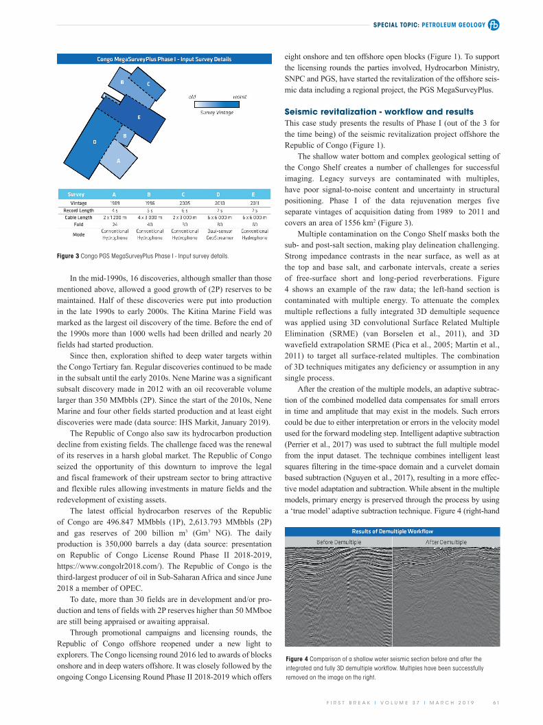
The shallow water bottom and complex geological setting of the Congo Shelf creates a number of challenges for successful imaging. Legacy surveys are contaminated with multiples, have poor signal-to-noise content and uncertainty in structural positioning. Phase I of the data rejuvenation merges five separate vintages of acquisition dating from 1989 to 2011 and covers an area of 1556 km2 (Figure 3).
Multiple contamination on the Congo Shelf masks both the sub- and post-salt section, making play delineation challenging. Strong impedance contrasts in the near surface, as well as at the top and base salt, and carbonate intervals, create a series of free-surface short and long-period reverberations. Figure 4 shows an example of the raw data; the left-hand section is contaminated with multiple energy. To attenuate the complex multiple reflections a fully integrated 3D demultiple sequence was applied using 3D convolutional Surface Related Multiple Elimination (SRME) (van Borselen et al., 2011), and 3D wavefield extrapolation SRME (Pica et al., 2005; Martin et al., 2011) to target all surface-related multiples. The combination of 3D techniques mitigates any deficiency or assumption in any single process.
After the creation of the multiple models, an adaptive subtrac-tion of the combined modelled data compensates for small errors in time and amplitude that may exist in the models. Such errors could be due to either interpretation or errors in the velocity model used for the forward modeling step. Intelligent adaptive subtraction (Perrier et al., 2017) was used to subtract the full multiple model from the input dataset. The technique combines intelligent least squares filtering in the time-space domain and a curvelet domain based subtraction (Nguyen et al., 2017), resulting in a more effec-tive model adaptation and subtraction. While absent in the multiple models, primary energy is preserved through the process by using a ‘true model’ adaptive subtraction technique. Figure 4 (right-hand
In the mid-1990s, 16 discoveries, although smaller than those mentioned above, allowed a good growth of (2P) reserves to be maintained. Half of these discoveries were put into production in the late 1990s to early 2000s. The Kitina Marine Field was marked as the largest oil discovery of the time. Before the end of the 1990s more than 1000 wells had been drilled and nearly 20 fields had started production.
Since then, exploration shifted to deep water targets within the Congo Tertiary fan. Regular discoveries continued to be made in the subsalt until the early 2010s. Nene Marine was a significant subsalt discovery made in 2012 with an oil recoverable volume larger than 350 MMbbls (2P). Since the start of the 2010s, Nene Marine and four other fields started production and at least eight discoveries were made (data source: IHS Markit, January 2019).
The Republic of Congo also saw its hydrocarbon production decline from existing fields. The challenge faced was the renewal of its reserves in a harsh global market. The Republic of Congo seized the opportunity of this downturn to improve the legal and fiscal framework of their upstream sector to bring attractive and flexible rules allowing investments in mature fields and the redevelopment of existing assets.
The latest official hydrocarbon reserves of the Republic of Congo are 496.847 MMbbls (1P), 2,613.793 MMbbls (2P) and gas reserves of 200 billion m3 (Gm3 NG). The daily production is 350,000 barrels a day (data source: presentation on Republic of Congo License Round Phase II 2018-2019, https://www.congolr2018.com/). The Republic of Congo is the third-largest producer of oil in Sub-Saharan Africa and since June 2018 a member of OPEC.
To date, more than 30 fields are in development and/or pro-duction and tens of fields with 2P reserves higher than 50 MMboe are still being appraised or awaiting appraisal.
Through promotional campaigns and licensing rounds, the Republic of Congo offshore reopened under a new light to explorers. The Congo licensing round 2016 led to awards of blocks onshore and in deep waters offshore. It was closely followed by the ongoing Congo Licensing Round Phase II 2018-2019 which offers
Figure 3 Congo PGS MegaSurveyPlus Phase I - Input survey details.
Figure 4 Comparison of a shallow water seismic section before and after the integrated and fully 3D demultiple workflow. Multiples have been successfully removed on the image on the right.

SPECIAL TOPIC: PETROLEUM GEOLOGY
6 2 F I R S T B R E A K I V O L U M E 3 7 I M A R C H 2 0 1 9
variations, such as fast carbonates terminating at the seafloor, were resolved using refraction-driven tomographic inversion. Once the near surface velocity features were captured, fast cycle velocity model building was undertaken using wavelet-shift tomography (Sherwood et al., 2011). With the speed and flexi-bility of the wavelet-shift tomography, in conjunction with fast-beam migration technology, a regional tilted transverse isotropy velocity model was built in a top-down fashion, using regional anisotropy trends, in nine weeks. Visible internal salt reflectivity indicating heterogeneous salt bodies were also captured in the final velocity model using wavelet-shift tomography.
The full velocity model building integrated flow accounted for all velocity variations from shallow subsalt targets and produces a regionally consistent model (Figure 6). To image the subsalt section both ray-based and wavefield extrapolation migrations were produced. To meet the technical challenges of the data a reverse time migration (RTM) was used. The RTM was implemented with an inverse scattering imaging condition to remove the correlated, in phase, backscattered and turning wave energy from the modelling component of the migration (Whitmore and Crawley, 2012). Both imaging methods produced a seismic section that was broadband and multiple-free, while compensating for the technical imaging challenges associated with the complexity of the geological setting (Figure 7).
Revitalised seismic data reveals potentialThe commercially viable oil and gas fields of the Congo Shelf lie within syn-rift and early post-rift sag-phase subsalt reservoirs as well as post-rift postsalt reservoirs. There has been renewed interest in exploring the subsalt since 2010 with the availability of better quality 3D regional seismic data imaged in depth and integrated with wireline data.
In the area of the Phase I data, no exploration wells have been drilled since the 2000s and half of the wells drilled targeting subsalt prospects are approximately 30 years old. In other words, most of the wells were drilled before the acquisition of the Phase I data. Historically, the subsalt exploration focused around and on top of the Kaba High in the northern half of the study area. As
section) shows that all free-surface multiples have been removed from the data, revealing the primary reflectivity.
Only one survey was acquired with a dual-sensor streamer. However, broadband processing was applied to all vintages of data. For the five conventional single-sensor recordings a processing deghosting solution, based on the wave-equation, was applied to the data to remove the receiver ghost. The deghosting operator aims to amplify the signal caused by the destructive interference between the up- and down-going waves, by performing a Receiver-base Bandwidth Optimization (RBO). The method uses an inversion approach to solve for the forward operator, which describes how all seismic events that are reflected by the surface of the sea create their associated ghost events. To deliver broadband seismic up to very high frequencies, the source ghost was also removed using Source-base Bandwidth Optimization (SBO). This further enhances the signal bandwidth by using a similar wave-equation based deghosting technique, producing a result with a near linear response on the amplitude spectra (Figure 5).
To resolve the imaging uncertainty, an integrated and cost-ef-fective model building flow was used to overcome the technical challenges of the Congo Shelf. It produced a 3D regionally consistent velocity model. Shallow short wavelength velocity
Figure 5 Amplitude spectra before and after deghosting. The final amplitude spectrum is shown in red (Receiver Bandwidth Optimization, RBO; Source Bandwidth Optimization, SBO; and Designature, Desig.).
Figure 6 Comparison of initial and reprocessed velocity models for pre-stack depth migration. A better resolution velocity model is available for the reprocessed data throughout the entire section.
Figure 7 Comparison of reprocessing results and legacy seismic data. The reprocessed image is broadband and multiple-free.

SPECIAL TOPIC: PETROLEUM GEOLOGY
F I R S T B R E A K I V O L U M E 3 7 I M A R C H 2 0 1 9 6 3
ervoir quality within the carbonates (Harris, 2000) that the higher quality data with pre-stack information may help to constrain.
A regional depth-migrated 3D volume is highly beneficial in derisking the subsalt play. The increase in confidence in the interpretation improves the positioning and geometry of the structural and stratigraphic traps, which in turn significantly derisks leads and prospects in the subsalt. In addition, the accuracy of the existing well positioning against depth migrated seismic data removes the previous risk associated with time-depth conversions, enabling a more accurate estimation of the various targets in depth.
Conclusion - A clearer image of the shallow water Congo ShelfThe rejuvenated exploration of the Congo Shelf, with the ongoing Congo Licensing Round Phase II 2018-2019, provides new opportunities in open acreage within a proven area. After 30 years of exploration and production offshore Congo there is a renewed focus on the shallow waters and exploration for overlooked subsalt accumulations on the Congo Shelf.
The new regional PGS MegaSurveyPlus data, covering the shallow water Congo Shelf, illuminates the proven subsalt, and postsalt plays. The data has been successfully organized, merged and integrated by SNPC and PGS, enhancing image resolution and data integrity and allowing accurate decisions to be made. The modern imaging techniques used on the multi-vintage data attenuate complex multiple reflections, deghost the source and receiver responses on the legacy surveys and resolve imaging uncertainty with an integrated regional model building flow.
Most of the wells drilled within the survey area predate the acquisition of the input surveys by at least eight years. Revaluation of these wells alongside the depth migrated dataset (including a multisensor survey) allows higher confidence interpretations and mapping, and leads to more accurate seismic facies analysis.
The subsalt petroleum system has further potential in the high-quality reservoirs of several formations within sizable struc-tural and stratigraphic traps. The new dataset demonstrates for the first time the presence of a subsalt Barremian mobile shale layer and identifies a number of various subsalt structures to explore. Discoveries made in analogous and proximal neighbouring con-text, such as the Ruche Marine North East-1 drilled in 2018, are
a consequence, in the southern half of the study area the subsalt plays seem to have been overlooked.
The revitalised seismic reveals many examples of structural and stratigraphic trapping scenarios within the subsalt across the shelfal area that were previously not imaged.
The imaging reveals the accurate location of faults separat-ing horst structures created during the rifting. The syn-rift horsts play host to the lower subsalt play. The resolution of the subsalt faults has overall been significantly improved thanks to the optimized imaging workflow. The Djeno and Vandji formation sandstones are proven reservoirs found in the tilted fault blocks. The Barremian shale layers in the subsalt section along with the Loeme Salt provide seals to the lower subsalt play (Figure 8). Exploration of the deep subsalt play is now possible using this rejuvenated data.
A Barremian shale layer appears to behave as a mobile shale in the subsalt section of the Congo Shelf (Figure 8). Only now is it possible to make this interpretation with such confidence. It has a detachment surface at its base, imbricated thrusts are observed within it, and various structures are observed at its top, such as shale diapirs, pillows and rollers.
Successful explorers from BW Offshore and Panoro Energy (in their 2018 investors presentation) identified such a mobile shale layer underneath the Ruche and Tortue fields in the Gabonese Ruche (Dussafu) block, located respectively 30 km and 15 km NW of the study area. They interpreted it as being the Crabe Member of the Dentale Formation equivalent to the Pointe Indienne Shale Formation.
This mobile shale layer presence, allowed the overlying fault blocks to rotate and in the extensional regime form roll-over anticlines which affect both the Pointe Indienne Shale and Chela formations of the upper subsalt play. The presence of the mobile shale layer in the Congo Shelf increases the chances of finding large subsalt structures on trend with the Ruche, Ruche Marine North East 1 and Tortue fields, all within the study area. There are four-way dip and fault-related closures at or near the base Loeme Salt within the Chela Sandstone and Pointe Indienne Shale Formation (Figure 8) and several examples of stratigraphic pinch out traps that are potential targets.
In the upper subsalt play, the Toca carbonate build-ups may host hydrocarbons. However, there are variations in facies and res-
Figure 8 Comparison of reprocessing results and vintage seismic data revealing subsalt structures. The reprocessing image on the right indicates: (1) small-scale imbricated thrusts within a mobile shale layer, (2) anticlinal structures above a mobile shale layer, (3) normal fault offset at Base Salt and (4) deep syn-rift tilted and truncated basement fault block.

SPECIAL TOPIC: PETROLEUM GEOLOGY
6 4 F I R S T B R E A K I V O L U M E 3 7 I M A R C H 2 0 1 9
IHS Markit EDIN Database [2019]. Exploration and Production.Martin, T., Brittan, J., Bekara., M. and Koch, K. [2011]. 3D Shallow water
demultiple – extending the concept. 73rd Annual EAGE Conference and Exhibition, Extended Abstracts.
Nguyen, T. and Liu, Y. J. [2017]. Seismic noise attenuation using curvelet transform and dip map data structures. 79th Annual EAGE Confer-ence and Exhibition, Extended Abstracts, We B3 08.
Panoro Energy [2018]. Investors Presentation, http://www.panoroenergy.com/wp-content/uploads/2018/01/Dussafu-development-summa-ry-January-2018.pdf.
Perrier, S., Dyer, R., Liu, Y., Nguyen T. and Lecocq, P. [2017]. Intelligent adaptive subtraction for multiple attenuation. 79th Annual EAGE Conference and Exhibition, We B3 03.
Pica, A., Poulain, G., David, B., Magesan, M., Baldock, S., Weisser, T., Hugonnet, P., Herrmann, Ph.[2005]. 3D surface-related multiple modelling. Leading Edge, 24 (3), 292-296.
Republic of Congo Ministry of Hydrocarbons [2018]. Republic of Congo License Round Phase II 2018-2019, https://www.congolr2018.com/.
Sherwood, J., Jiao, J., Tieman, H., Sherwood, K., Zhou, C., Lin, S., and Brandsberg-Dahl, S. [2011]. Hybrid tomography based on beam migration. SEG Annual Conference, Expanded Abstracts, 3979–3983.
Van Borselen, R., Hegge, R., Martin, T., Barnes, S., Aaron, P. [2011] Enhanced demultiple by 3D SRME using dual-sensor measurments. The Leading Edge, 30 (8), 920-926.
Whitmore, N.D. and Crawley, S. [2012] Application of RTM inverse scattering imaging conditions, 82nd Annual International Meeting. SEG Annual Conference, Expanded Abstracts.
very encouraging and confirm the subsalt potential of the shallow water Congo Shelf.
The advances in imaging techniques now provide a high-qual-ity depth migrated dataset over the Congo Shelf where the possibility for near-field exploration, optimizing capital expend-iture costs and reducing technical risks, provides an attractive opportunity to build on the previous success.
AcknowledgmentsWe would like to thank the Republic of Congo Ministry of Hydrocarbons and SNPC for their collaboration and permission to publish the data.
ReferencesBaer, S., Coole, P., Ngouala Nzoussi, A.R., Débi Obambé, B.W., Kiwuba,
S.P. and Brice, E. [2014]. Regional Prospectivity, Offshore the Republic of the Congo. AAPG, Extended Abstracts, #10645.
Brownfield, M.E. and Charpentier, R.R. [2006]. Geology and total petroleum systems of the West-Central Coastal Province (7203), West Africa: U.S. Geological Survey Bulletin, 2207-B, 52.
Cole, G. A., Requejo, A. G., Ormerod, D., Yu, Z. and Clifford, A. [2000]. Petroleum geochemical assessment of the Lower Congo Basin. In: Mello, M.R. and Katz, B.J. (Eds.), Petroleum systems of South Atlantic margins. AAPG Memoir, 73, 325–339.
Harris, N.B. [2000]. The Toca Carbonate, Congo Basin: Response to an Evolving Rift Lake. In: Mello, M.R. and Katz, B.J. (Eds.), Petroleum Systems of South Atlantic Margins. AAPG Memoir, 73, 341-360.
A D V E R T I S E M E N T
25TH
European Meeting of Environmental and
Engineering Geophysics
1ST
Conference on Geophysics for Geothermal and
Renewable Energy Storage
Conference on Geophysics for Infrastructure Planning,
Monitoring and BIM
1ST
8 - 1 2 S E P T E M B E R 2 0 1 9
T H E H A G U E , T H E N E T H E R L A N D S
WWW.NSG2019.ORG
#NSG2019
Call for Abstracts Now Open!
NS19-V2H.indd 1 16/11/2018 14:52