Embed Size (px)
Citation preview
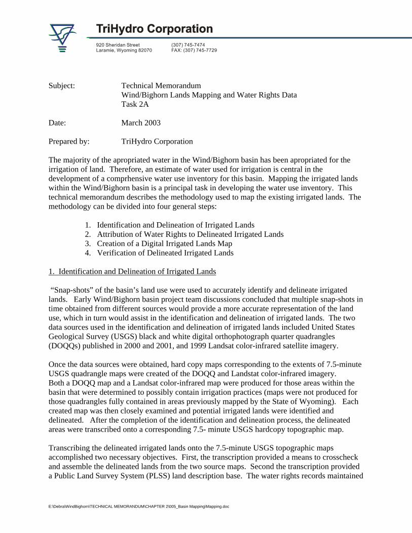
Subject: Technical Memorandum
Wind/Bighorn Lands Mapping and Water Rights Data Task 2A
Date: March 2003 Prepared by: TriHydro Corporation The majority of the apropriated water in the Wind/Bighorn basin has been apropriated for the irrigation of land. Therefore, an estimate of water used for irrigation is central in the development of a comprhensive water use inventory for this basin. Mapping the irrigated lands within the Wind/Bighorn basin is a principal task in developing the water use inventory. This technical memorandum describes the methodology used to map the existing irrigated lands. The methodology can be divided into four general steps:
1. Identification and Delineation of Irrigated Lands 2. Attribution of Water Rights to Delineated Irrigated Lands 3. Creation of a Digital Irrigated Lands Map 4. Verification of Delineated Irrigated Lands
1. Identification and Delineation of Irrigated Lands “Snap-shots” of the basin’s land use were used to accurately identify and delineate irrigated lands. Early Wind/Bighorn basin project team discussions concluded that multiple snap-shots in time obtained from different sources would provide a more accurate representation of the land use, which in turn would assist in the identification and delineation of irrigated lands. The two data sources used in the identification and delineation of irrigated lands included United States Geological Survey (USGS) black and white digital orthophotograph quarter quadrangles (DOQQs) published in 2000 and 2001, and 1999 Landsat color-infrared satellite imagery. Once the data sources were obtained, hard copy maps corresponding to the extents of 7.5-minute USGS quadrangle maps were created of the DOQQ and Landstat color-infrared imagery. Both a DOQQ map and a Landsat color-infrared map were produced for those areas within the basin that were determined to possibly contain irrigation practices (maps were not produced for those quadrangles fully contained in areas previously mapped by the State of Wyoming). Each created map was then closely examined and potential irrigated lands were identified and delineated. After the completion of the identification and delineation process, the delineated areas were transcribed onto a corresponding 7.5- minute USGS hardcopy topographic map. Transcribing the delineated irrigated lands onto the 7.5-minute USGS topographic maps accomplished two necessary objectives. First, the transcription provided a means to crosscheck and assemble the delineated lands from the two source maps. Second the transcription provided a Public Land Survey System (PLSS) land description base. The water rights records maintained
E:\Debra\WindBighorn\TECHNICAL MEMORANDUM\CHAPTER 2\005_Basin Mapping\Mapping.doc
by Wyoming State Engineer and the State Board of Control reference land based on the PLSS therefore, the same base was required for the assignment of water rights to the delineated lands. As mentioned above, portions of the irrigated lands within the Wind/Bighorn basin were previously mapped by the State of Wyoming. The previously mapped areas include irrigated lands within the boundaries of the Wind River Indian Reservation and lands that irrigate water from the Bighorn River or tributaries to the Bighorn River. Within the Wind River Reservation, water awards for the “future” development of irrigated lands were also mapped. The water awards were determined for three different circumstances and are therefore referred to with three different names – Reserved Right Awards, Walton Awards and Remand Awards. The lands covered under each of the water awards may or may not be currently irrigated, however the water awards have an 1868 priority and therefore play an important role in determining the water use or potential water use of the Wind/Bighorn basin. 2. Attribution of Water Rights to Delineated Irrigated Lands Water rights attribution is the process of assigning water right information to the delineated irrigated land areas or polygons. A complete description of irrigated lands includes a definition of the water rights granted to allow for the irrigation of the lands. The water right information most relevant to this project include: permit number, source of water supply, facility name, priority date, amount of appropriation, permitted number of acres, and type of supply. Specifically these water rights attributes provide an overview and insight into the supply sources, the permitted area of land, and the types of irrigation systems. The identification and attribution of water rights was addressed upon the completion of the irrigated lands mapping. Each of the irrigated land polygons transcribed onto the USGS 7.5 minute topographic maps were attributed with the appropriate water right information. The water rights assigned to the irrigated land polygons were identified from the original records on file in the offices of the Wyoming State Engineer and State Board of Control. As a water right was determined to be associated to an irrigated land polygon, an identification number was assigned to the topographic map clearly referencing the appropriate polygon. After the identification number was written on the map, it was then entered into a water rights database referencing the appropriate water right. The identification number created a link between the irrigated polygon or polygons and the water rights database. During the assignment of water rights to irrigated lands, points of diversions for irrigation ditches that divert water at a rate of 10 cubic feet per seconds or greater were plotted and also assigned the same identification number which referenced the appropriate water right and irrigated land polygon. If a delineated land polygon was found not to contain a water right, the polygon was reclassified to sub-irrigated land. Sub-irrigated land is land that receives water from a semi-saturated subsurface zone and not directly from an irrigation source. An assumption of “officially permitted water right use” was made throughout the mapping process. Therefore, any lands that appeared to be receiving water yet did not have an appropriated water right were assigned to the sub-irrigated category. As previously mentioned, the Wyoming State Engineer’s office and the State Board of Control’s water right information is tied to irrigated lands through a PLSS description. The process of associating water rights to irrigated lands using a PLSS description results in some accuracy
2
limitations, which warrant notation. For example, if water right permit # 1086 irrigates 5 acres in the SW ¼ of the NW ¼ but, the irrigated lands delineated on the 7.5 USGS topographic map illustrates multiple polygons equaling 15 acres in the SW ¼ of the NW ¼, each of the polygons in the quarter-quarter section will be assigned the water right attribute of permit #1086. An inverse scenario is possible as well. Water right permit #225 may irrigate 15 acres in the SE ¼ of the NE ¼; however, the map illustrating the irrigated lands for the SE ¼ of the NE ¼ may only show a single 5 acre polygon leaving 10 acres of permitted irrigated land unrecorded. Throughout the water rights attribution process of the Wind/Bighorn basin it was discovered that historic water rights still exist within some town boundaries (i.e. Otto and Greybull). To maintain consistency with previously completed basin plans, these water rights were excluded from the final irrigated lands map. 3. Creation of a Digital Irrigated Lands Map Upon the completion of the water rights attribution, the delineated lands and water rights attributes were converted into a digital format. The first step in the conversion process involved registering or georeferencing each of the USGS 7.5 minute topographic maps to real world coordinates. Established control points located on the USGS maps were used in the georeferencing process in order to minimize the introduction of registration error. Once the maps were registered the irrigated and sub-irrigated lands were digitized utilizing practices that maintained USGS 1:24000 mapping standards. AutoCAD Map software was used to both register the maps and digitize the delineated lands. After the maps were digitized, the AutoCAD map files were converted into ArcView shapefiles. Utilizing custom-built ArcView tools created for this project, the irrigated land polygons were attributed with the appropriate water rights. The creation of an ArcView point file representing the points of diversion was also created and attributed in the same manner as the irrigated land polygons. With the completion of the digital irrigated lands and points of diversion, verification maps were created. 4. Verification of Delineated Irrigated Lands Throughout the delineation process, inquiries were made to irrigation districts and landowners in order to verify the accuracy of the information obtained from the DOQQs and the Landsat color-infrared imagery. In cases where the accuracy was questioned, field-truth verification was performed by members of the Wind/Bighorn project team, landowners, or irrigation district personnel. A second iteration of field verification took place upon completion of the digital data conversion process. The second verification involved the creation of maps illustrating the irrigated lands and the points of diversion. These maps were delivered to Mr. Craig Cooper, retired Wyoming State Engineer’s Office Division III Superintendent, and Mr. Gary Collins, former Wind River Reservation Tribal Water Engineer, who both acted as primary project field verification contacts. The pertinent additions and changes from the second field verification process were incorporated into the final mapping products using the same procedures outlined in the previous section.
3
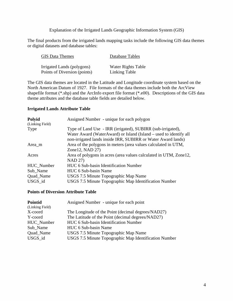
Explanation of the Irrigated Lands Geographic Information System (GIS) The final products from the irrigated lands mapping tasks include the following GIS data themes or digital datasets and database tables: GIS Data Themes Database Tables Irrigated Lands (polygons) Water Rights Table Points of Diversion (points) Linking Table The GIS data themes are located in the Latitude and Longitude coordinate system based on the North American Datum of 1927. File formats of the data themes include both the ArcView shapefile format (*.shp) and the ArcInfo export file format (*.e00). Descriptions of the GIS data theme attributes and the database table fields are detailed below. Irrigated Lands Attribute Table Polyid (Linking Field)
Assigned Number - unique for each polygon
Type Type of Land Use - IRR (irrigated), SUBIRR (sub-irrigated), Water Award (WaterAward) or Island (Island – used to identify all non-irrigated lands inside IRR, SUBIRR or Water Award lands)
Area_m Area of the polygons in meters (area values calculated in UTM, Zone12, NAD 27)
Acres Area of polygons in acres (area values calculated in UTM, Zone12, NAD 27)
HUC_Number HUC 6 Sub-basin Identification Number Sub_Name HUC 6 Sub-basin Name Quad_Name USGS 7.5 Minute Topographic Map Name USGS_id USGS 7.5 Minute Topographic Map Identification Number Points of Diversion Attribute Table Pointid (Linking Field)
Assigned Number - unique for each point
X-coord The Longitude of the Point (decimal degrees/NAD27) Y-coord The Latitude of the Point (decimal degrees/NAD27) HUC_Number HUC 6 Sub-basin Identification Number Sub_Name HUC 6 Sub-basin Name Quad_Name USGS 7.5 Minute Topographic Map Name USGS_id USGS 7.5 Minute Topographic Map Identification Number
4
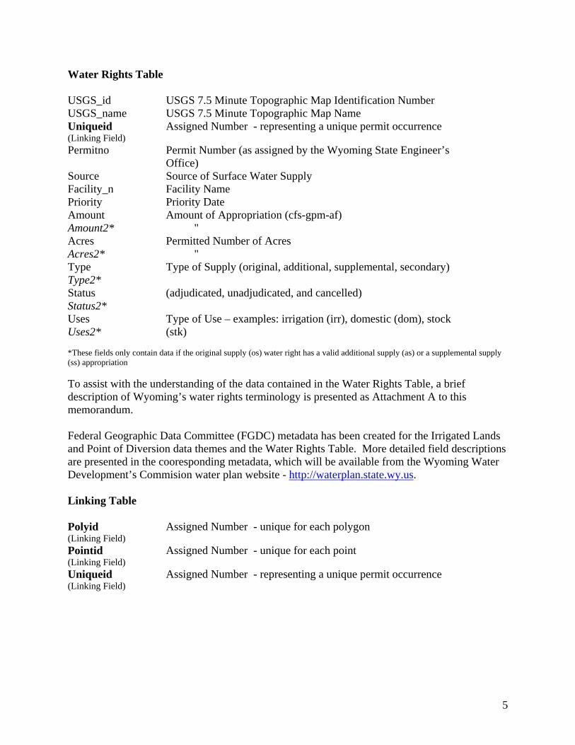
Water Rights Table USGS_id USGS 7.5 Minute Topographic Map Identification Number USGS_name USGS 7.5 Minute Topographic Map Name Uniqueid (Linking Field)
Assigned Number - representing a unique permit occurrence
Permitno Permit Number (as assigned by the Wyoming State Engineer’s Office)
Source Source of Surface Water Supply Facility_n Facility Name Priority Priority Date Amount Amount2*
Amount of Appropriation (cfs-gpm-af) "
Acres Acres2*
Permitted Number of Acres "
Type Type2*
Type of Supply (original, additional, supplemental, secondary)
Status Status2*
(adjudicated, unadjudicated, and cancelled)
Uses Uses2*
Type of Use – examples: irrigation (irr), domestic (dom), stock (stk)
*These fields only contain data if the original supply (os) water right has a valid additional supply (as) or a supplemental supply (ss) appropriation To assist with the understanding of the data contained in the Water Rights Table, a brief description of Wyoming’s water rights terminology is presented as Attachment A to this memorandum. Federal Geographic Data Committee (FGDC) metadata has been created for the Irrigated Lands and Point of Diversion data themes and the Water Rights Table. More detailed field descriptions are presented in the cooresponding metadata, which will be available from the Wyoming Water Development’s Commision water plan website - http://waterplan.state.wy.us. Linking Table Polyid (Linking Field)
Assigned Number - unique for each polygon
Pointid (Linking Field)
Assigned Number - unique for each point
Uniqueid (Linking Field)
Assigned Number - representing a unique permit occurrence
5
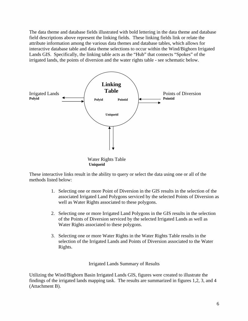
The data theme and database fields illustrated with bold lettering in the data theme and database field descriptions above represent the linking fields. These linking fields link or relate the attribute information among the various data themes and database tables, which allows for interactive database table and data theme selections to occur within the Wind/Bighorn Irrigated Lands GIS. Specifically, the linking table acts as the “Hub” that connects “Spokes” of the irrigated lands, the points of diversion and the water rights table - see schematic below. Irrigated Lands Points of Diversion Polyid Pointid
Linking Table
Polyid Pointid Uniqueid
Water Rights Table Uniqueid
These interactive links result in the ability to query or select the data using one or all of the methods listed below:
1. Selecting one or more Point of Diversion in the GIS results in the selection of the associated Irrigated Land Polygons serviced by the selected Points of Diversion as well as Water Rights associated to these polygons.
2. Selecting one or more Irrigated Land Polygons in the GIS results in the selection
of the Points of Diversion serviced by the selected Irrigated Lands as well as Water Rights associated to these polygons.
3. Selecting one or more Water Rights in the Water Rights Table results in the
selection of the Irrigated Lands and Points of Diversion associated to the Water Rights.
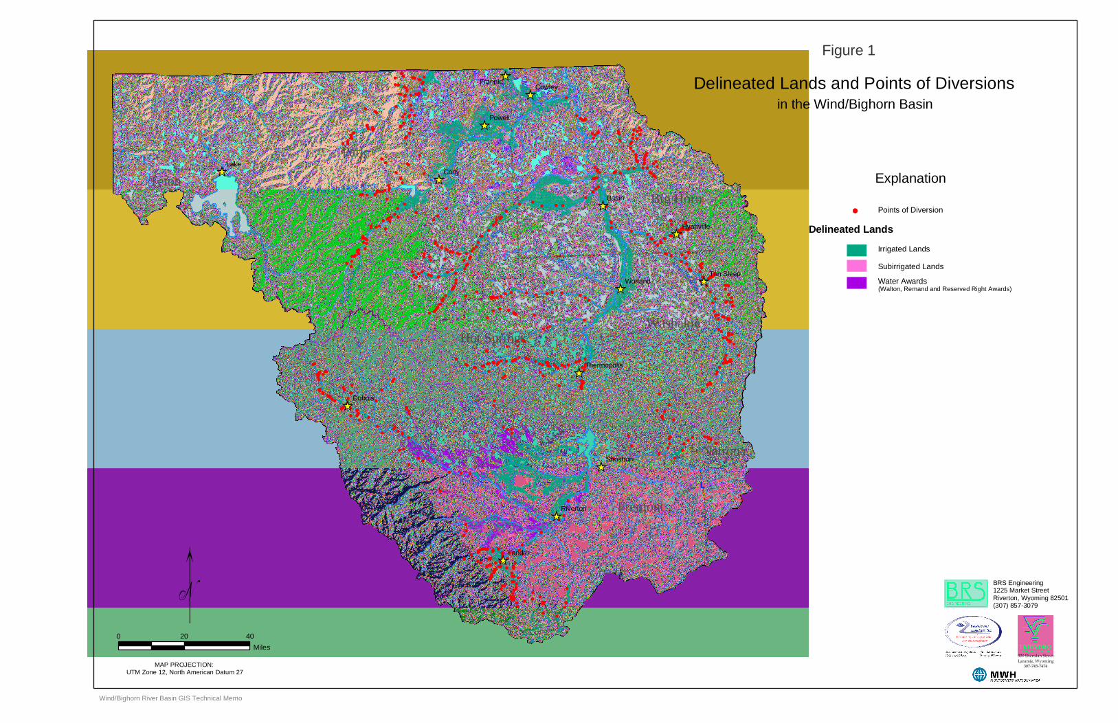
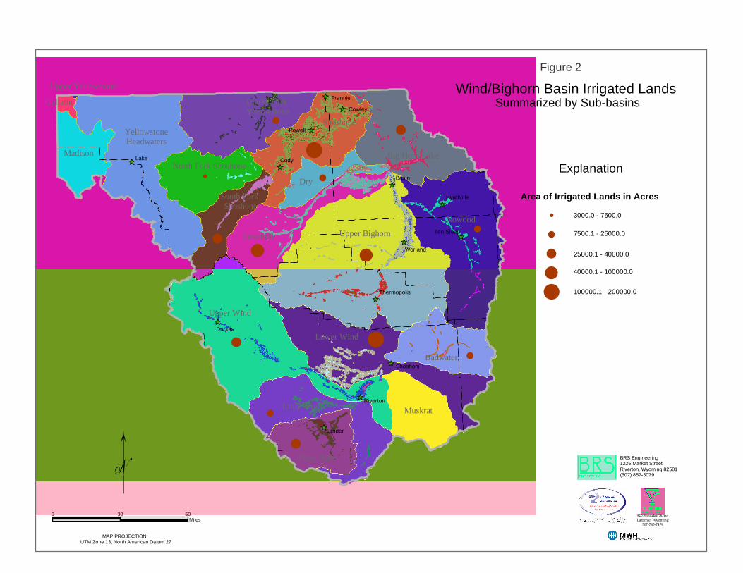
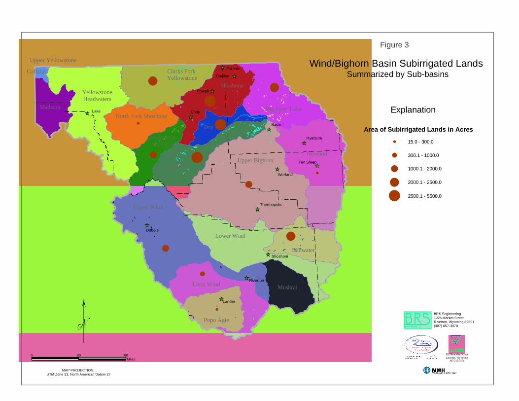
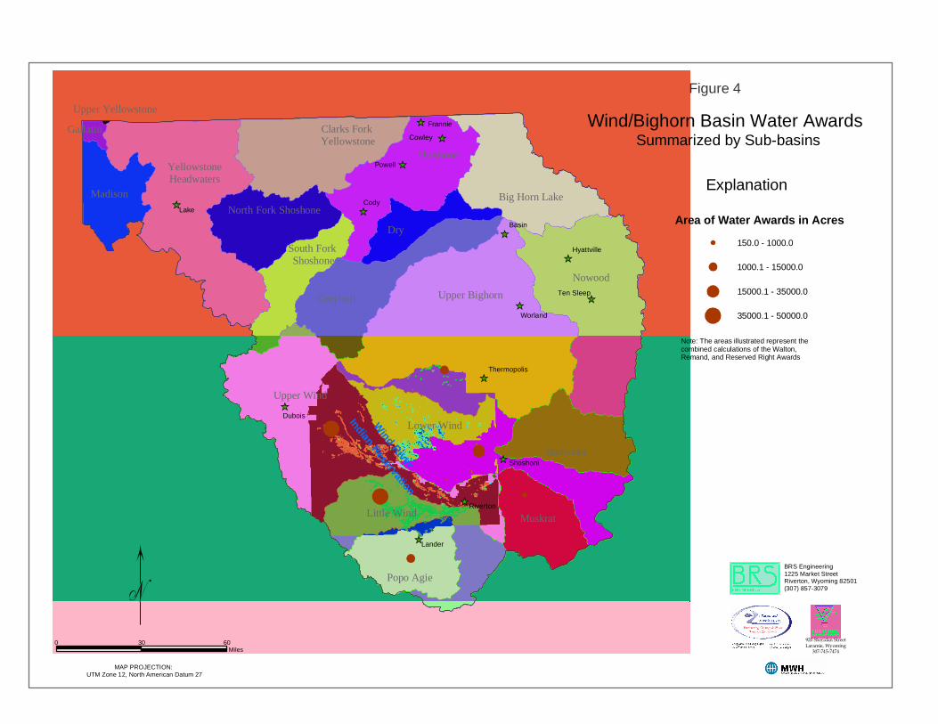
Irrigated Lands Summary of Results Utilizing the Wind/Bighorn Basin Irrigated Lands GIS, figures were created to illustrate the findings of the irrigated lands mapping task. The results are summarized in figures 1,2, 3, and 4 (Attachment B).
6
Attachment A – Wyoming Water Rights Terminology Water Right Priority Related Terminology Surplus Water: Whenever the supply of water in a stream reaches the point where there is water available over and above the needed to fill all appropriations with a priority senior to March 1, 1945, then this stream is in surplus flow condition. When surplus flows are available, the water is to be divided proportionally among the senior rights up to an additional 1.0 cfs to every 70 acres or 1.0 cfs to every 35 acres total supply. (W.S 41-3-319-324) Excess Water: Each water right with a priority date of post March 1, 1945 but pre March 1, 1985 is entitled to 2.0 cfs for every 70 acres before any water is made available to post March 1, 1985 water rights. If there is insufficient water to furnish 2.0 cfs to each post March1, 1945 and pre March 1, 1985 water right, but more than enough to furnish 1.0 cfs to each of these rights, the excess water is divided among those rights on a pro-rata basis. (W.S. 41-4-330) Territorial Appropriation: This is an appropriation of water with a priority date prior to statehood. These rights were filed under a system of statement of claims to water under territorial law rather than a permit system. They were adjudicated after statehood by the then-established State Board of Control. No permits numbers were assigned to those water rights, and they can be identified only by the proof number. Water Right Type of Supply Related Terminology Original Supply: Original supply is a water right attached to land or uses where there is no other water right of record. It is the first priority water right attached to and to be used on the identified land. Supplemental Supply: Direct flow water from a different source and different point of diversion to augment or supplement the available water for an existing appropriation (water right) for which the original source does not provide a full supply constitute a supplemental supply. The amount of supplemental water which may be diverted is the amount available, in priority, to bring the total water diverted from all sources up to the appropriated amount of 1.0 cubic foot per second (cfs) for every 70 acres to be irrigated. (W.S. 41-3-113) Additional Supply: Additional supply is additional water to lands or uses which already have a valid existing water right. It can be additional water to surface water irrigation and/or groundwater irrigation. Water Right Status Related Terminology Unadjudicated Permit: This is a permit that has not been fully perfected. It can be in the construction stage through the application of water to beneficial use. When the permit is issued by the State Engineer, the applicant is given time limits to commence construction, complete construction, and apply the water to beneficial use. While all this is taking place the permit is considered as “unadjudicated”. Adjudicated Permit: This is a permit where the notice of completion of beneficial use has been filed, proof of appropriation prepared, a field inspection made with the finding that the facility is built within the terms of the permit, the proof advertised with no protests, and the proof considered and allowed b the State board of Control. After these items are completed, an order of the Board and the Certificate of Appropriation are prepared, issued, and recorded in the court house of the respective county and made a matter of record in the Tabulation of Adjudicated Water Rights.
i

Direct Flow Appropriation: This is an appropriation of water that diverts from a surface water source and is measured in cubic feet per second (cfs). The appropriation is granted by the State Engineer and gives the appropriator the right to divert water as set out in the permit. The statutes set the amount of diversion for irrigation at a rate of 1.0 cfs for every seventy (70) acres to be irrigated. (W.S. 41-3-317) Court Decrees: A small number of water rights were confirmed (adjudicated) by court decrees prior to the creation of the State Board of Control.
ii
LakeCody
Basin
Cowley
Powell
Dubois
Lander
Frannie
Worland
Shoshoni
Riverton
Ten Sleep
Hyattville
Thermopolis
Delineated Lands and Points of Diversions
0 20 40
Miles
Explanation
Wind/Bighorn River Basin GIS Technical Memo
MAP PROJECTION: UTM Zone 12, North American Datum 27
Park
Teton
Hot Springs
Fremont
Natrona
Washakie
Big Horn
Figure 1
in the Wind/Bighorn Basin
Delineated Lands
Irrigated Lands
Subirrigated Lands
Water Awards
Points of Diversion
(Walton, Remand and Reserved Right Awards)
BRS Engineering1225 Market StreetRiverton, Wyoming 82501(307) 857-3079
920 Sheridan StreetLaramie, Wyoming
307-745-7474
Nowood River
Big
hor n
Riv
er
Gre
ybul
l Rive
r
Shosh
one
River
North Fork Shoshone River
Wind River
Nowood
Upper Bighorn
Upper Wind
Lower Wind
Greybull
Shoshone
Dry
Little Wind
Badwater
Muskrat
YellowstoneHeadwaters
Big Horn Lake
Popo Agie
Madison
Clarks Fork Yellowstone
North Fork Shoshone
South Fork Shoshone
Gallatin
Upper Yellowstone
Lake Cody
Basin
Cowley
Powell
Dubois
Lander
Frannie
Worland
Shoshoni
Riverton
Ten Sleep
Hyattville
Thermopolis
Wind/Bighorn Basin Irrigated LandsSummarized by Sub-basins
BRS Engineering1225 Market StreetRiverton, Wyoming 82501(307) 857-3079
920 Sheridan StreetLaramie, Wyoming
307-745-7474
MAP PROJECTION: UTM Zone 13, North American Datum 27
Explanation
Area of Irrigated Lands in Acres
0 30 60Miles
3000.0 - 7500.0
7500.1 - 25000.0
25000.1 - 40000.0
40000.1 - 100000.0
100000.1 - 200000.0
Figure 2
NowoodUpper Bighorn
Upper Wind
Lower Wind
Greybull
Shoshone
Dry
Little Wind
Badwater
Muskrat
YellowstoneHeadwaters
Big Horn Lake
Popo Agie
Madison
Clarks Fork Yellowstone
North Fork Shoshone
South Fork Shoshone
Gallatin
Upper Yellowstone
Lake Cody
Basin
Cowley
Powell
Dubois
Lander
Frannie
Worland
Shoshoni
Riverton
Ten Sleep
Hyattville
Thermopolis
Wind/Bighorn Basin Subirrigated LandsSummarized by Sub-basins
BRS Engineering1225 Market StreetRiverton, Wyoming 82501(307) 857-3079
920 Sheridan StreetLaramie, Wyoming
307-745-7474
MAP PROJECTION: UTM Zone 13, North American Datum 27
Explanation
Area of Subirrigated Lands in Acres
15.0 - 300.0
300.1 - 1000.0
1000.1 - 2000.0
2000.1 - 2500.0
2500.1 - 5500.0
0 30 60Miles
Figure 3
Nowood
Upper Bighorn
Upper Wind
Lower Wind
Greybull
Shoshone
Dry
Little Wind
Badwater
Muskrat
YellowstoneHeadwaters
Big Horn Lake
Popo Agie
Madison
Clarks Fork Yellowstone
North Fork Shoshone
South Fork Shoshone
Gallatin
Upper Yellowstone
LakeCody
Basin
Cowley
Powell
Dubois
Lander
Frannie
Worland
Shoshoni
Riverton
Ten Sleep
Hyattville
Thermopolis
Wind/Bighorn Basin Water AwardsSummarized by Sub-basins
BRS Engineering1225 Market StreetRiverton, Wyoming 82501(307) 857-3079
920 Sheridan StreetLaramie, Wyoming
307-745-7474
MAP PROJECTION: UTM Zone 12, North American Datum 27
Explanation
Area of Water Awards in Acres
0 30 60Miles
Figure 4
Wind River
Indian Reservation
150.0 - 1000.0
1000.1 - 15000.0
15000.1 - 35000.0
35000.1 - 50000.0
Note: The areas illustrated represent the combined calculations of the Walton, Remand, and Reserved Right Awards