Embed Size (px)
Citation preview
O O Q O f: \ O O <J o u -J.
Schroeter, Tom EM:EX
From: Schroeter, Tom EM:EX Sent: Friday, October 27, 2000 6:57 AM To: 'Leonard W. Saleken' Subject: RE: Hedley Basin Gold Project
Thanks, Tom.
From: Sent: To: Subject:
Tom:
Leonard W. Saleken[SMTP: [email protected]] Thursday, October 26, 2000 9:14 PM Schroeter, Tom EM: EX Re: Hedley Basin Gold Project
Mike was on site Oct 26, it is "elephant country" and for some reason the Panorama Ridge showing got missed. Workings could go back to 1900?, Placer Dome missed the target. Will keep you informed. Regards LWS — Original Message — From: "Schroeter, Tom EM:EX" <[email protected]> To: <[email protected]> Sent: Tuesday, October 24, 2000 11:52 AM Subject: Hedley Basin Gold Project
> Len, thanks very much for dropping off a copy of your most recent report -> sorry I wasn't in. Good luck with the project! Tom.
Page 1
Schroeter, Tom EM:EX
From: Cathro, Mike EM:EX Sent: Friday, October 27, 2000 12:50 PM To: Adams, Rick EM.EX Cc: Britton, Jim; Brown, Derek; Lefebure, Dave; Ludwig, Allan; Madu, Bruce; McArthur, Gib; Payie,
Garry; Schroeter, Tom; Houle, Jacques; Lane, Bob; Wilton, Paul; Wojdak, Paul Subject: Cathro Weekly to 10/27/2000
HIGHLIGHTS: Fox (Gitennes Exploration Inc.) - In the last week the company has completed hand trenching and recce geophysical surveys on this exciting new Zn-Cu-Pb-Ag-Au showing located 8.1 metres west of the paved surface of the Coquihalla highway, 20 mins north of Merritt. One IP line was completed but a second was stopped short when the RCMP and Ministry of Highways advised the crew that they were not allowed to drag their wires across four lanes of freeway traffic. Nevertheless, both IP lines show a decent changeability anomaly dipping to the west, and a Genie EM "rover" survey shows a weak conductor that is traceable for at least 250 m, considerably longer than the 120 m exposed in the road cut. Hand pitting several hundred metres south of the showing is attempting to trace the showing in that direction but is being hampered by a 1 m thick layer of imported rip rap which covers the bank. A $60K helicopter EM-Mag survey, at 150 m line spacing, is being flown this week by Fugro of Toronto (formerly Geoterrex-Dighem etc.). Next, Gitennes would like to establish a grid and run a full IP survey, with the baseline located in the median strip between the northbound and southbound lanes! The Ministry of Highways has concerns about safety.
Staking by competitors appears to have slowed down, perhaps because people are beginning to realize the size of Gitennes' claim block and their head start. So far Gitennes has recorded 227 claim units (approx 5600 Ha) and additional staking is still underway. Not all the other players will become evident for a while because of the delay in recording claims and finalizing deals. During my last visit on 10/23, several representatives of Toronto and Vancouver-based junior companies were on site and said they are negotiating with Gitennes to joint venture portions of the property. In addition, Goldcliff Resources has added claims to their "S" property to the north, and 42 units have been staked nearby by a private group made up of John Kerr, Warner Gruenwald and Robert Montgomery. On Swakum Mountain, 8 km SW of Fox, the large "How" claim group controlled by Ahura Mining is slated to lapse next Wednesday, November 1. Ahura has been working on this property recently so perhaps they will file assessment work prior to the forfeit date. One of the most obvious targets in the belt, the "LDM
showing (92ISE052) at Iron Mountain near Merritt has been staked this week by Lloyd Addie. The LD does not appear to have been drilled before despite hosting baritic massive sulphides with anomalous Cu-Zn-Pb-Ag-Au values and a sizable Ba-Zn-Pb-Cu soil anomaly. Other baritic massive sulphide showings at Iron Mountain (e.g. Comstock) are on the "Diane" claims controlled by Lexam Explorations of Toronto but this property has been dormant for several years. I will try to prepare a compilation of the Nicola belt for Round-up, in conjunction with GSB. In addition, Paul Schiarizza and I have tentatively planned a field visit next week to review the regional geology and controls on mineralization.
Panorama Ridge (Goldcliff Resource Corp) - Field visit with Len Saleken and Grant Crooker to this newly staked 28 unit property, located 3.5 km east of the Nickel Plate mill site near Hedley. New roads and active logging activity have exposed a very impressive 500 m long gossan. This area is not mentioned in MINFILE although numerous old trenches and adits are present. Several large exavator trenches were dug in the mid 1980s by Placer Dome, one of which averaged 0.68 ppm Au over 45 m, including 6 m grading 1.33 ppm Au. Mineralization consists of disseminated and fracture controlled pyrite in strongly silicified sediments (Hedley Fm?) and narrow dikes or sills. Float of pyroxene skam and massive pyrite are also present. No drilling appears to have been done and the property would appear to be an excellent bulk tonnage gold target. Exploration work will probably have to wait until next spring.
OTHER: Compiling list of exploration projects, spending and drilling for exploration review talk and for comparison with Schroeters list.
Page 1
Page 1 of2
Schroeter, Tom EM:EX X T / ^ ^ / W / / ^ ^
From: Leonard W. Saleken [[email protected]] Sent: Thursday, August 23, 2001 5:21 PM
To: GoldcilffGCN Subject: Gold cliff Panorama Ridge, Hedley Gold Basin, Hedley, BC
GOLDCLIFF RESOURCE CORPORATION Suite 920 -470 Granville Street, Vancouver, British Columbia, Canada V6C 1V5
Tel: (604) 685-5685 Fax: ( 604) 685-5686 Email: [email protected] Web: www.qoldcliff.com
GCN.CDNX (Trading SymboI.Exchange) & USA Exemption 12g3-2b:82-2748
GOLDCUFF RESOURCE CORPORATION (GCN.CDNX) has made a new gold discovery at Hedley, BC - one-half ounce gold per tonne (0.58 ounces /tonne) - on its Panorama Ridge property in the Hedley Gold Basin, Nickel Plate mining district, British Columbia. This discovery is 3.5 kilometres east of the world-class gold skarn Nickel Plate gold mine (Barrick/Homestake) which produced in excess of 2,500,000 ounces gold over the last 100 years. There is a saying in the mining business:
"the best place to find a mine is near another mine"
Goldcliff's Hedley Basin Gold Project, the Panorama Ridge Property, is located 230 kilometres east of Vancouver, British Columbia, Canada and 40 kilometres north of the State of Washington's USA border. Goldcliffs claim holdings cover 102 units totaling 2,550 hectares (6,299 acres) and are the largest holdings in the Nickel Plate mining district next to Barrick/Homestake. Over the past 100 years, the Nickel Plate mine has produced 2.52 million ounces gold (78,500 kilograms) from three auriferous gold skarn ore bodies (Nickel Plate, Sunnyside, Bulldog) grading from 0.10 to 0.50 ounces/tonne gold (3.0 to 14.0 grams/tonne) from underground and oper pit operations.
The Company is targeting high-grade auriferous skarn gold deposits on its Panorama Ridge property that show similarities to the Nickel Plate ores. Goldcliffs 2001 exploration target, which covers an area of 800 by 600 metres (2600 by 2000 feet), contains three promising auriferous skarn occurrences: Spar, York and Nordic prospects. York prospect returned continuous gold values averaging 0.81 grams/tonne Au over 45 metres (including 6 metres of 1.34 grams/tonne Au.) and a 9.2 grams/tonne gold skarn sample. The Spar showing contains a high-grade gold-skarn containing 0.58 ounces/tonne gold (18.04 grams/tonne). The Nordic prospect, a large area of auriferous disseminated sulphide mineralization and calc-silicate skarn alteration contains gold values ranging from 0.50 to 1.00 gramsAonne.
Goldcliff's management team, and its President, Leonard W. Saleken, have the experience and expertise to explore and develop the Panorama Ridge property. As Exploration Manager for Mascot Gold Mines, Len Saleken, PGeo (geologist) was part of the Nickel Plate mine team that put the mine back into production in 1987 for the third time in history. As a Goldcliff Director, Edwin R. Rockel, PGeo (mining geophysicist) was a geophysical contractor and consultant for Mascot Mines that discovered new ore deposits at the Nickel Plate mine. Dr. Francis Whiting, PEng, PhD (geological engineer) is a Goldcliff Director that worked at Nickel Plate in the 1950s and has world-wide mining expertise in mine operations.
Goldcliff has exploration funds and this year's program is underway. Sampling and fieldwork will lead to trenching and drilling in the fall. Goldcliffs shares trade as GCN (trading symbol) on the Canadian Venture Exchange (CDNX). At recent prices of under $0.20, the Company is capitalized at less than $3,000,000 with considerable upside.
Enclosed is an INVESTOR INFORMATION package on the PANORAMA RIDGE PROPERTY, HEDLEY GOLD BASIN.
08/24/2001
Page 1 of2
Schroeter, Tom EM:EX
From: Adams, Rick EM:EX Sent: Thursday, August 23, 2001 1:36 PM To: Anderson, Duane; Beckett, Carla; Beswick, Ed; Booth, Richard; Braidwood, Brian; Carr, Chris; Carter,
Tom; Cheetham, Pat; Curtis, Ross; Errington, John; Ferguson, Susan; German, Gerald; Graeme McLaren (E-mail); Hall, Ted; Hermann, Fred; Hoffman, Al; John Clancy (E-mail); Jorgensen, Sharon; Lewis, Jim; Lieutard, Denis; McArthur, Gib; McKillop, Greg; Murphy, Maureen; Nash, Laurel; O'Rourke, Patrick; Rennie, Loma; Rick Conte (E-mail); Roberts, Steve; Schroeter, Tom; Shelley Guthrie (E-mail); Smyth, Ron; Starkes, Terri; Stewart, Linda; Walter Poohachoff (E-mail); Whale, Andrew
Cc: Allan Ludwig (E-mail); Britton, Jim; Cathro, Mike; Heistad, Ray; Horton, Russ; Madu, Bruce; Mehr, Eugene; Patricia Murton (E-mail); Rothman, Stephen; Seguin, Joe; Wallis, Yvonne; Worsfold, Joyce
Subject: South Central Region to August 23, 2001 issues: Barisoff/Mclntyre Pit, Oliver- Following a hearing in Kelowna on July 3, 2001, Justice Drossos provided Reasons for Judgment on July 27, 2001. The Judgment: clarified the court's December 4th Judgment; declined to exercise its discretion to reopen that Judgment; and dismissed the petitioners' Notice of Motion in its entirety with taxable costs to the respondents (Barisoff, the Regional District, and the Crown). Counsel for the petitioners has filed Notice of Appeal.
Highland Valley Copper- Two DOs occurred on August 13. In the first DO, a one ton service truck going for routine maintenance hit the rear of an empty fuel tanker traveling in the same direction. Weather and roads were good at the time of the accident. The service truck is a suspected write-off, while the fuel truck had only minor damage. The driver of the service truck had minor injuries, was taken to Logan Lake hospital as a precaution, and returned to work the next day. Cause is under investigation.
In the second DO, a mine technician drove his pickup into a ribboned off area and over an embankment on the 1130 bench. The truck slid 5-6 metres down the face before contacting a pile of sand and stopping. Weather and roads were good at the time of the accident. The driver was shook up but unhurt. Cause is under investigation.
Cariboo Tribal Council NoW referrals- MEM is experiencing difficulty receiving comments from the CTC and individual Bands on NoW referrals. CTC explain the situation as: they have a capacity problem; they have agreements with MOF and MWLAP to provide funding; and, unless we pay them too, our referrals go to the bottom of their pile.
TulameeryCoal (Compliance Coal Corp) - Mining of coal began on 8/13/2001 following a week of stripping and sitejDcepfA D8 dozer, Cat 230 excavator and a screening plant are now on site, under the management of Larry EeTHT(formerly of ForcHnojCoal). 1 flOOO tonnes will be selectively mined over the next three weeks, screened to
minus 3 inch, and trucKeo TO potential customers beginning in early Sept. Attaining a reasonably low ash content (<12-15%) will be the biggest challenge for the company. On a historical note, the start of coal mining took place^-71 years to the day after the tragic underground explosion at the nearby Coalmont#4 mine, which killed 45 men.
Exploration Activity: Little Fort Field Trip-24_people_atte,nded this successful field trip to the Little Fort area August 10. Led by M. Cathro, P. Schiarizza, and R. Paulen, the group was updated on the progress of Schiarizza's geological mapping in the area. In addition, R. Paulen outlined the glacial geology and reviewed overlays of till geochemical data from the 1997 and 1998 GSB till surveys. Several exploration projects and mineral prospects were visited including Cedar (Cu-Au), Deer Lake (Au-Cu), Worldstock (Cu-Au) and Crazy Fox (Zn-Cu).
Panorama Ridge (Goldcliff Resources Corp)- Diamond saw channel sampling of more than 125 one-metre samples has beeii completed over the Noxdic prospect, a skarn gold showing located a fe_WLkrrTeast of the Nickel Plate mine. Three grab samples collected last fall ran about 0.5 g/t Au. A large program of excavator trenching on the prospect and the nearby York target is planned for early fall. Concerns expressed today by the Nickel Plate X-Country Ski Club regarding possible impacts on the ski trails/roads they use.
Verity (Commerce Resources Corp.)-the company restated the grade and tonnage of this deposit at Blue River
08/24/2001
Page 1 of3
Schroeter, Tom EM:EX »%£ From: Leonard W. Saleken [[email protected]] Sent: Saturday, January 26,2002 3:31 PM To: GoldcilffGCN Cc: [email protected] Subject: GCNnews2202 - Hedley 2001 Exploration Highlites & Gold Rock Sample Map attached
attached
GOLDCLIFF RESOURCE CORPORATION Suite 920 - 470 Granville Street, Vancouver, BC, Canada V6C 1V5
Tel: (604) 685-5685 Fax: ( 604) 685-5686 Email: [email protected] Web: www.qoldcliff.com
GCN.CDNX (Trading SymboI.Exchange) & USA Exemption 12g3-2b:82-2748
NEWS RELEASE JANUARY 23. 2002
HEDLEY GOLD BASIN PROJECT, PANORAMA RIDGE PROPERTY
2001 EXPLORATION RESULTS
GOLDCLIFF RESOURCE CORPORATION (GCN.CDNX) is pleased to provide the high lights of the 2001 exploration program on the Hedley Gold Basin Project, Panorama Ridge Property, Nickel Plate Mining District, Hedley, British Columbia, Canada. The Company is exploring for gold skarn deposits and is targeting high-grade strata-bound gold skarn ores similar to the Nickel Plate mine. The 2001 work program focused on an exploration target area covering approximately 48 hectares (120 acres) and regional property prospecting. The Panorama Ridge Property is situated 3.5 kilometres east of the Nickel Plate mine.
The Panorama Ridge Property is located 230 kilometres east of Vancouver and 40 kilometres west of Penticton. The property covers 2,850 hectares (7,040 acres) and is largest land holdings next to Barrick Gold Corporation's Nickel Plate mine. The claims contain an extensive area of skarn alteration and sulphide mineralization that has been exposed by new logging roads. The property is underlain by Late Triassic Nicola Group sedimentary and volcanic rocks of the Hedley and Whistle Formations and diorite intrusive rocks of the Hedley Intrusions. These rocks host the gold skarn ore deposits at the Nickel Plate mine. The Nickel Plate mine has produced 78,500 kilograms gold (2.52 million ounces) over the past 100 years. The gold production was from strata-bound and disseminated gold skarn ore bodies (Nickel Plate, Sunnyside, Bulldog) that graded from 3.0 to 20.0 grams/tonne gold (0.10 to 0.60 ounces/tonne). The Nickel Plate Mine closed in 1996.
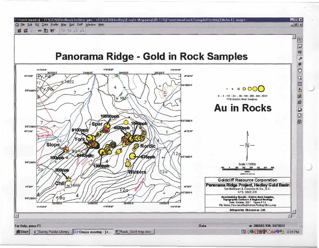
Similar gold skarn mineralization that was mined at the gold skarn ore deposits at the Nickel Plate mine occur on the Panorama Ridge Property. The 2001 work by Goldcliff has identified several gold prospects containing strata-bound and disseminated gold skarn mineralization. Within the exploration target area, the Spar, York, Nordic, Winters and Slope prospects occur. The Skar and Chill prospects are located outside the target on the property.
Surface sampling was the focus of the 2001 exploration work program: rocks (from outcrop to talus), soils ("B horizon") and silts (active stream sediments). A total of 899 samples were collected: 65 silts, 300 soils and 534 rocks. The samples were all analysed for gold (30 gram fire Au) and 28 elements (ICP). The most important factor in discovering gold skarn deposits is gold. Of particular importance to the discovery of gold skarn deposits in the Hedley Gold Basin is the relationship of gold to key pathfinder elements. The key pathfinder elements to gold (Au) are arsenic (As), bismuth (Bi), cobalt (Co), chrome (Cr), copper (Cu), nickel (Ni), antimony (Sb) and zinc (Zn). In the gold business - - gold is where you find it and not where you think it is - - sampling, more sampling and more-more sampling is never enough to discover that elusive gold skarn deposit!
2002-01-28
Page 2 of3
The exploration results at Panorama Ridge are very encouraging. The stream sediment sampling program located a new area for investigation. The area is in the eastern portion of the claims and east of Winters Creek . The silt sample returned a highly anomalous gold value of 1250 ppb Au. The soil survey was limited to the area covering the Spar, York and Nordic prospects. It was conducted to confirm previous sampling and to establish a broader and more consistent geochemical data base for pathfinder elements. The soil survey proved to be very beneficial and located new areas for investigation. The gold values are a magnitude high than the results of the 1984 survey. The higher values for gold are attributed to the analytical methods - fire assay (2001) verses aqua regia (1984).
A vast improvement in gold values was achieved at the known prospects with the rock sampling. The rock sampling resulted in the discovery of two new prospects: a high grade gold skarn (Skar) and a strata-bound gold skam (Winters). The Skar prospect is located approximately one kilometres south west of the York and along the western edge of the property. Sampling (rock chips) over two continuous metres returned the following:
Sample 2068: 9.77 grams/tonne Au (0.285 ounces/tonne)
Sample 2069:14.57 grams/tonne Au (0.425 ounces/tonne)
The Winters prospect is located directly south of the Nordic on the east side of Panorama Ridge. Talus sampling (rock grads) at four locations returned gold values of 200, 200, 460 and 675 ppb gold. The samples are strata-bound gold skarn with layered massive pyrite and pyrrhotite. The Winters and the Nordic prospect contain very similar gold skarn mineralization.
GOLDCLIFF RESOURCE CORPORATION (continued)
The Nordic prospect received the bulk of the rock sampling. The sample results from this years work greatly improved the gold values at Nordic. The best sample value from the previous year was 0.485 grams/tonne gold. The best gold value for 2001 is 4.930 grams/tonne. The Nordic prospect is an area of disseminated gold skarn mineralization that occurs over
an area of approximately 700 metres NE to SW and 200 metres NW to SE. Nine outcrops were channel sampled. The samples were cut using a diamond saw and sampled at one metre intervals. The high lights of the channel sampling are as follows:
Outcrop 1:11.0 metres averaged 0.765 grams/tonne with 3 metres of 1.583 grams/tonne
7.0 metres averaged 0.859 grams/tonne with 2 metres of 1.015 grams/tonne Outcrop 2: 9.0 metres averaged 1.085 grams/tonne with 3 metres of 2.780 grams/tonne
Outcrop 3: 3.0 metres averaged 0.543 grams/tonne with 1 metres of 0.920 grams/tonne
Outcrop 6: 12.0 metres averaged 0.723 grams/tonne with 3 metres of 1.017 grams/tonne
The talus sample values (rock grabs) from the Nordic area ranged from 200 to 1550 ppb gold.
The rock sampling at the York returned gold results that are similar to previous years sampling. The disseminated gold skarn mineralization in Trench 3 (1985) contains continuous gold values over 45 metres averaging 0.81 grams/tonne gold (including 6 metres of 1.34 grams/tonne gold). A select gold skarn sample from an old hand pit returned 9.2 grams/tonne gold. The strata-bound gold skarn mineralization with layered massive pyrite and pyrrhotite returned gold values of 0.46 to 2.44 grams/tonne gold.
The Spar prospect contains disseminated mineralization with anomalous gold values in the range of 100 to 300 ppb gold. A select gold skarn sample from 2000 assayed 18.04 grams/tonne gold (0.53 ounces/tonne). The Slope and the Chill prospects are exposed in old hand pits and contain anomalous gold values in the 100 to 200 ppb Au range.
The exploration results at Panorama Ridge are very encouraging and further exploration in 2002 is warranted.
2002-01-28
Page 3 of 3
Goldcliff's exploration has greatly improved the gold potential of the property.
The exploration target area has favourable geology, gold skarn prospects, coincidental gold (Au) and pathfinder (As-Bi-Co-Ni-Sb-Cu-Zn) geochemical anomalies, magnetic and induced polarisation (chargeability) highs, and electromagnetic (VLF) conductors - - all the exploration indicators for Nickel Plate strata-bound and disseminated gold skarn deposits.
The Notice of Work is in place for trenching and drilling in 2002. Goldcliff is upgrading and evaluating its geological, geochemical and geophysical data base on the property on a continuous basis in order to optimise its 2002 exploration work program.
GOLDCLIFF RESOURCE CORPORATION
Per: "Leonard W. Saleken"
Leonard W. Saleken, PGeo
President, Director, CEO
The Canadian Venture Exchange (CDNX) has not reviewed and does not accept responsibility
for the adequacy or accuracy of the contents of this news release.
gcnnews2202
EXPLORATION TATGRT AREA MAP IS ATTACHED
Target area 1000 metres x 500 metres
Gold Target Objective: gold skarn deposits in the 1.0 to 18.0 grams/tonne range, 1,000,000 plus ounces gold targets
2002-01-28
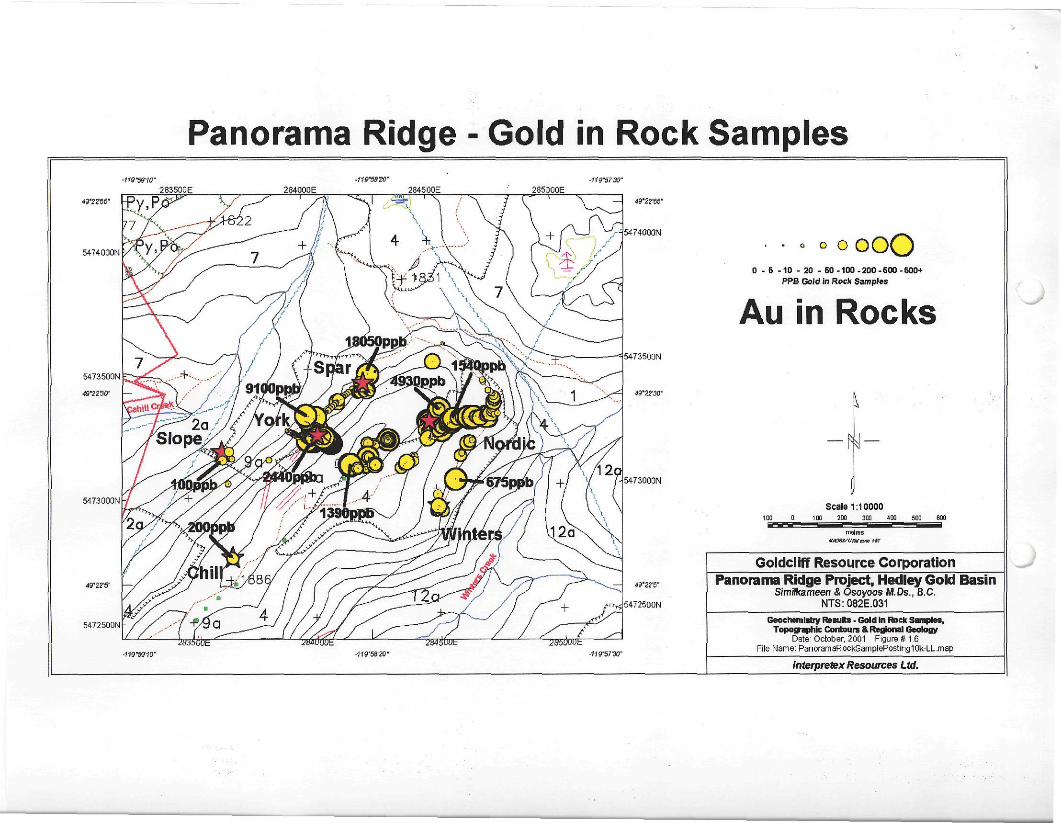
C^Oasis montaj - D: \GCN\Hedley\Hedley qws - <D \GCN\I l ed ley \ rag lR Mapping\0n-1 i r ) \PannramaRockSamplePnst inq10kAu LI. mop> File Edit GX Data Profile Map Grid DAP Window Help
HNSES - I f f x
Panorama Ridge - Gold in Rock Samples
:3s
a m
S
5474000N h
4t'22'S' —
5472 5DDN ■
_283500E — 49'21W
5474000 N
'■ 5473500 N
• • © o o o O 0 - 5 -10 - 20 - 50-100-200-500-500+
PPBOoldin Rock Samples
Au in Rocks
N -
Sceie 1:10000 im a s mn 4m ffio an
IWttJ
Goldcliff Resource Corporation Panorama Ridge Project, Hedley Gold Basin
Similkameen& OsoyoosM.Ds.,B.C. NTS:0S2E.031
Geochemistry Resits - GoW in Rick Samples. Topographic Cortours A Regional Gedogy
Date: October, 2001 Figure I11 J3 File Name: PanoramaRookSample Posting 1Ok-LL.map
MetpiQfar Resoutces Ltd.
For Help, press F1
M Start {j; # j Surrey Public Library... <> Oasis montaj - [<... E|]Rock_Gold map.doc ...j
Data m: 286583.938. 5473612
SS^SPFi)^^*ci 2:34 PM
Panorama Ridge - Gold in Rock Samples 283500E 284000E 285000E
5474000IM
5472500N
5473500N
283500E
o O oooO 0 - 5 -10 - 20 - 50 -100 -200 -600 -600+
PPB Gold in Rock Samples
Au in Rocks
Scale 1:10000 100 0 100 200 300 400 500 600
mat res M/oaa/untaux i *
Goldclrff Resource Corporation Panorama Ridge Project, Hedley Gold Basin
Sim ilka rneen & Osoyoos M.Ds.. B.C. N T S : 0 8 2 E . 0 3 1
Geochemistry Results - Gold In Rock Samples, Topographic Contours & Regional Geology
Date: October, 2001 Figure # 1.6 File Name: PanoramaRockSamplePosting10k-LL.map
interpretex Resources Ltd.
Page 1 of2
Schroeter, Tom EM:EX
From: Leonard W. Saleken [[email protected]] Sent: Wednesday, February 27, 2002 11:39 AM
To: GokJctlff Subject: Panorama Ridge - Two new gold areas discoverd
LEONARD W. SALEKEN REPORTS: NEW GOLD DISCOVERIES AT PANORAMA RIDGE , HEDLEY, BC, CANADA
GOLDCUFF RESOURCE CORPORATION, Suite 920 - 470 Granville Street, Vancouver, BC, Canada V6C
1V5
Tel: (604) 685-5685 Fax: ( 604) 685-5686 Email: [email protected] Web: www.goldcliff.com
GCN.CDNX (Trading SymboI.Exchange) & USA Exemption 12g3-2b:82-2748
NEWS RELEASE FEBRUARY 27. 2002
NEW GOLD DISCOVERIES - PANORAMA RIDGE PROPERTY - HEDLEY GOLD BASIN PROJECT GOLDCLIFF RESOURCE CORPORATION (GCN.CDNX) is pleased announce two new gold discoveries on the Hedley Gold Basin Project, Panorama Ridge Property, Nickel Plate Mining District, Hedley, British Columbia, Canada. The Company is exploring for gold skam deposits and is targeting high-grade strata-bound gold skarn ores similar to the Nickel Plate mine. The continued evaluation of the 2001 property prospecting results on its 2,850 hectare property has identified two new gold areas for detailed investigation in 2002. The Panorama Ridge Property is situated 3.5 kilometres east of the Nickel Plate mine by Homestake (Barrick Gold Corporation).
The Panorama Ridge Property is located 230 kilometres east of Vancouver and 40 kilometres west of Penticton. The property covers 2,850 hectares (7,040 acres) and is largest land holdings in the Nickel Plate mining district. The claims contain an extensive area of skarn alteration and sulphide mineralization that has been exposed by new logging roads. The property is underlain by Late Triassic Nicola Group sedimentary and volcanic rocks of the Hedley and Whistle Formations and diorite intrusive rocks of the Hedley Intrusions. These rocks host the gold skarn ore deposits at the Nickel Plate mine. The Nickel Plate mine has produced 78,500 kilograms gold (2.52 million ounces) over the past 100 years. The gold production was from strata-bound and disseminated gold skarn ore bodies (Nickel Plate, Sunnyside, Bulldog, Canty) that graded from 3.0 to 20.0 grams/tonne gold (0.10 to 0.60 ounces/tonne). The Nickel Plate mine closed in 1996.
Similar gold skarn mineralization that was mined at the gold skarn ore deposits at the Nickel Plate mine occur on the Panorama Ridge Property. Because of its aerial extent (2,850 hectares), the Panorama Ridge Property has been subdivided into three exploration target regions that are referred to as the North, Central and South regions. The 2001 work by Goldcliff concentrated on the North region and has identified several gold prospects containing strata-bound and disseminated gold skam mineralization that include the Spar, York, Nordic, Winters, Slope Skar and Chill prospects.
The stream sediment survey in the North region of the property has identified two new gold areas for detailed investigation. The two areas occur in thick overburden. Both areas cover approximately 65 hectares. The discovery of these areas is based on anomalous gold and pathfinder element values in stream sediment samples (silts). Both of the areas are located north and east of the any known gold prospects on the Panorama Ridge Property.
Goldcliff is in the process of completing its stream sediment survey compilation and interpretation. This includes the 1976 and 1982 joint BC and Federal government national stream sampling geochemical reconnaissance surveys (RGS) that covered NTS 82E (Penticton sheet 1:250,000) and NTS 92H (Hope sheet 1:250,000). The RGS survey includes the Panorama Ridge property. The complete results of the stream sediment survey compilation and interpretation will be reported.
2002-03-04
^ff"
Page 2 of2
The exploration results at Panorama Ridge are very encouraging for 2001. The new prospects discovered in the North region include the Skar high grade gold skarn and the Winters strata-bound gold skarn. The Skar prospect returned 9.77 grams/tonne Au (0.285 ounces/tonne) and 14.57 grams/tonne Au (0.425 ounces per tonne) over two metres. The Winters prospect returned a gold value of 675 ppb gold in a grab sample (0.657 grams/tonne Au). The Nordic prospect received the bulk of the rock sampling (2001). The best channel sample values from the Nordic showings (nine located 2001) are as follows:
Outcrop 1: 3.0 metres of 1.583 grams/tonne or 11.0 metres averaging 0.765 grams/tonne
Outcrop 2: 3.0 metres of 2.780 grams/tonne or 9.0 metres averaging 1.085 grams/tonne
Outcrop 6: 3.0 metres of 1.017 grams/tonne or 12.0 metres averaging 0.723 grams/tonne
Goldcliff's exploration 2001 has greatly improved the gold potential of the property. The exploration results at Panorama Ridge are very encouraging and further exploration in 2002 is warranted.
GOLDCLIFF RESOURCE CORPORATION
Per: "Leonard W. Saleken"
Leonard W. Saleken, PGeo
President, Director, CEO
The Canadian Ventura Exchange (CDNX) has not reviewed and does not accept responsibility
for the adequacy or accuracy of the contents of this news release.
gcnnews2204
2002-03-04
Page 1 of3
Schroeter, Tom EM:EX X ^ C p ? ftW^
From: Leonard W. Saleken [[email protected]] I? Sent: Tuesday, July 30, 2002 12:34 PM To: Undisclosed-Recipient:@cedar.itsd.gov.bc.ca; Subject: Goldcliff GCNNews2218
GOLDCLIFF RESOURCE CORPORATION, Suite 920 - 470 Granville Street, Vancouver, BC, Canada V6C
1V5
Tel: (604) 685-5685 Fax: ( 604) 685-5686 Email: [email protected] Web: www.qoldcliff.com
GCN.TSXV (Trading SymboI.Exchange) & USA Exemption 12g3-2b:82-2748
NEWS RELEASE JULY 30. 2002
2002 PANORAMA RIDGE EXPLORATION IN PROGRESS GOLDCLIFF RESOURCE CORPORATION (GCN.TSXV) is pleased announce that the Company has commenced exploration on its Panorama Ridge Property in the Hedley Gold Basin, Nickel Plate Mining District, Osoyoos Mining Division, BC. The field work in progress on the Panorama and Epic gold targets consists of detailed grid soil geochemical and geophysical surveying, trenching and geological mapping.
The Panorama Ridge gold property is located 230 kilometres east of Vancouver, British Columbia, Canada, 40 kilometres north of the state of Washington's US border and six kilometres east of Hedley, in the Hedley Gold Basin, southern British Columbia. The Panorama Ridge gold skarn property is situated 3.5 kilometres east of the world-class gold skarn producing Nickle Plate mine (2.5 million ounces gold). The property is 100 per cent-owned and operated by Goldcliff Resource Corporation and consists of 2,550 hectares in the Osoyoos Mining Division, British Columbia, Canada. The mining infrastructure on the Panorama Ridge property is in place with roads, water sources, communication lines and electrical power. Goldcliffs exploration on Panorama Ridge has identified two gold targets for exploration similar to the Nickel Plate gold skarn ore deposits.
The Panorama target was discovered in 2000 along new logging roads. The target is located along the crest of Panorama Ridge (1850 metres elevation) and covers an area 400 metres (north-west to south-east) by 1000 metres (north-east by south-west). Outcrop exposure is less than 5 per cent. The Panorama target includes the York, Spar and Nordic prospects that occur in Hedley Formation sittstone and limestone. The prospects contain gold skarn mineralization and alteration similar to the Nickel Plate mine. Gold mineralisation is related to strata-bound massive sulphides of pyrrhotite and pyrite and disseminated sulphides of pyrrhotite and pyrite. Significant gold values are associated with the prospects ranging from 0.250 to 18.05 grams per tonne. The prospects contain all the important pathfinder elements that are associated with gold skarn mineralisation at Nickel Plate: arsenic (As), bismuth (Bi), cobalt (Co), nickel (Ni) and antimony (Sb). The target area contains a strong gold soil geochemical anomaly. Geophysically, the Panorama target is located in a broad magnetic low and coinciding resistivity low region (alteration zone) with magnetic highs (Hedley diorite). The changeability values that define the limits of the Panorama target are strongly anomalous (between three and six times background) indicating the presence of sulphide mineralization. The average gold grade of over 500 rock samples collected from the prospects is 0.323 grams per tonne.
The Nordic prospect consists of several disseminated gold skarn mineralized outcrops occurring over an area of approximately 700 metres NE to SW and 200 metres NW to SE. along the eastern boundary (Winters Creek side) of the Panorama target. The best gold value is 4.930 grams/tonne over one metre. The highlights of the rock channel sampling returned the following gold results:
Outcrop 1: 11.0 metres averaged 0.765 grams/tonne with 3 metres of 1.583 grams/tonne
Outcrop 2: 9.0 metres averaged 1.085 grams/tonne with 3 metres of 2.780 grams/tonne
2002-08-06

Page 2 of3
Outcrop 6: 12.0 metres averaged 0.723 grams/tonne with 3 metres of 1.017 grams/tonne
The Spar prospect is located 400 metres west of the Nordic and occurs central to the Panorama target along its western boundary (Cahill Creek side). The Spar prospect contains disseminated gold skarn mineralization with anomalous gold values in the range of 100 to 300 ppb gold. A select gold skarn sample (float) assayed 18.04 grams/tonne gold (0.53 ounces/tonne). The source of the high-grade float has not been located in outcrop.
The York prospect is located 300 metres south-west of the Spar. Several old hand pits and a 50 metre trench (Placer Development, 1985) identify the area of the York prospect. Both strata-bound and disseminated gold skarn mineralization are present in Hedley Formation siltstone and limestone. The strata-bound gold skarn mineralization with layered massive pyrite and pyrrhotite returned gold values of 0.46 to 2.44 grams/tonne gold. The disseminated gold skarn mineralization in trench 3 (Placer 1985) contains continuous gold values over 45 metres averaging 0.81 grams/tonne gold (including 6 metres of 1.34 grams/tonne gold). A select gold skarn sample from an old hand pit returned 9.2 grams/tonne gold. Geologically, the disseminated gold skarn mineralization is interpreted to be up section (north-east) from the strata-bounded gold skarn mineralization. The limy sediments of the Hedley Formation containing the gold skarn mineralization are steeply dipping and structurally complex.
The Epic target is an IP geophysical discovery. The target is located 200 metres north-west of the Panorama target and covers an area 400 metres by 400 metres at 1800 metres elevation. The Epic Target occupies a southwest gently sloping hillside that is heavily overburdened. Outcrop in the area is sparse. The underlying geology is Hedley Formation. The target area contains a strong gold soil geochemical anomaly on its southern flank. Geophysically, the Epic target is located in a broad magnetic low and coinciding resistivity low region (alteration zone) with a magnetic high (Hedley diorite). The changeability values are strongly anomalous (between three and six times background) indicating the presence of sulphide mineralization.
The exploration results at Panorama Ridge are very encouraging. Goldcliffs exploration has greatly improved the gold potential of the property and discovered two important target areas for exploration.
The Panorama Ridge exploration target areas have favourable Hedley geology, gold skarn prospects, coincidental gold (Au) and pathfinder (As-Bi-Co-Ni-Sb-Cu-Zn) geochemical anomalies similar to the Nickel Plate ores. In addition to the geology and geochemistry, magnetic and induced polarisation (changeability) highs, and electromagnetic (VLF) conductors provide all of the exploration indicators for Nickel Plate strata-bound and disseminated gold skarn deposits.
Work irt progress on the Panorama and Epic gold targets consists of detailed grid soil geochemical and geophysical surveying, trenching of the Spar and York prospects, geological mapping and sampling. Work on the Nordic prospect is pending due to logging activities. Drilling is planned for later in the field season as follow up to the detail work required to establish drill targets. Drilling companies have been contacted for tenders. The analytical work is being conducted by Eco-Tech Laboratories Ltd. in Kamloops, BC. A field office and warehouse have been established in Keremeos, BC.
Gold cliff has sufficient funds to carry the pre-d rilling exploration work. The funds were raised by two non-brokered private placements to net the treasury $227,500. Current working capital is approximately $ 225,000 in cash for exploration and corporate purposes. Additional financing will be required to conduct the drilling program.
GOLDCLIFF RESOURCE CORPORATION
Per: "Leonard W. Saleken"
Leonard W. Saleken, PGeo
2002-08-06
Page 1 o f 3
Schroeter, T o m EM:EX
From: Leonard W. Saleken [[email protected]] Sent: Friday, September 13, 2002 9:31 AM
To: Goldcliff ^....Gjj^Z Subject: Goldcliff Panorama Ridge - August 2002 Exploration Update '
GOLDCLIFF RESOURCE CORPORATION, Suite 920-470 Granville Street, Vancouver, BC, Canada V6C
1V5
Tel: (604) 685-5685 Fax: ( 604) 685-5686 Email: [email protected] Web: www.qoldcliff.com
GCN.TSXV (Trading SymboI.Exchange) & USA Exemption 12g3-2b:82-2748
NEWS RELEASE SEPTEMBER 13. 2002
PANORAMA RIDGE -AUGUST 2002 EXPLORATION UPDATE GOLDCLIFF RESOURCE CORPORATION (GCN.TSXV) is pleased announce an exploration update on its Panorama Ridge gold property in the Hedley Gold Basin, Nickel Plate Mining District, Osoyoos Mining Division, British Colombia, Canada. The field work on the Panorama and Epic gold targets consisted of five excavator trenches, detailed in-fill grid soil geochemical and geophysical magnetic-electromagnetic surveying and detailed chip and cut-channel rock sampling. Trenching has exposed 100 metres of continuous skarn alteration and sulphide mineralisation on the York prospect. Prospecting to the south-west of the Panorama target located a new gold skarn prospect - the Tower. Soil sampling around the Skar prospect has located a strong gold anomaly associated with high-grade gold skarn values. A regional stream silting program located anomalous gold values and the staking of additional claims to bring Goldcliffs mineral land holdings to approximately 3,750 hectares (9,300 acres).
The Panorama Ridge gold property is located 230 kilometres east of Vancouver, British Columbia, Canada, 40 kilometres north of the state of Washington's US border and six kilometres east of Hedley, in the Hedley Gold Basin, southern British Columbia. The Panorama Ridge gold property is situated 3.5 kilometres east Nickle Plate mine - a world-class gold skarn deposit producing 2.5 million ounces gold. The Panorama Ridge property is 100 per cent-owned and operated by Goldcliff Resource Corporation and consists of 3,750 hectares in the Osoyoos Mining Division, British Columbia, Canada. The mining infrastructure on the Panorama Ridge property is in place with roads, water sources, communication lines and electrical power. Goldcliffs exploration on Panorama Ridge has identified two gold skarn target areas (Epic and Panorama) for exploration similar to the Nickel Plate gold skarn ore deposits. New gold finds have been identified.
The Panorama gold target is located on both sides of the crest of Panorama Ridge (1850 metres elevation) and covers an area 400 metres (north-west to south-east) by 1000 metres (north-east by south-west). Outcrop exposure is less than 5 per cent. The Panorama target includes the York, Spar and Nordic prospects that occur in Hedley Formation siltstone and limestone. The prospects contain gold skarn mineralization and alteration similar to the Nickel Plate mine. Gold mineralisation is related to strata-bound massive sulphides and disseminated sulphides of pyrrhotite and pyrite. Significant gold values that are associated with the prospects range from 0.250 to 18.05 grams per tonne gold. The prospects contain all of the important pathfinder elements that are associated with gold skarn mineralisation at the Nickel Plate mine: arsenic (As), bismuth (Bi), cobalt (Co), nickel (Ni), antimony (Sb), tellurium (Te) and copper (Cu). Geochemically, the target area contains coincidental strong gold soil geochemical anomalies along with arsenic and copper. Geophysically, the Panorama target is located in a broad magnetic and resistivity low (hydrothermal alteration zone) with distinctive magnetic highs representing Hedley intrusive diorite bodies. The IP changeability values that define the Panorama target are strongly anomalous (between three and six times background) indicating the presence of sulphide mineralisation. The average gold grade from rock samples collected from the Panorama prospects is 0.323 grams per tonne.
The Epic gold target is a hidden gold target that is identified by a strong IP changeability high geophysical anomaly and a coincidental strong gold soil anomaly. The target is located 200 metres north-west of the Panorama target and covers an area 400 metres by 400 metres at 1800 metres elevation. The Epic Target
2002-09-19
Page 2 of3
occupies a south-west gently sloping hillside that is heavily overburdened. Outcrop in the area is sparse. The target area contains a strong gold soil geochemical anomaly with anomalous gold values ranging from 20 to 850 ppb. Geophysically, the Epic target is located in a broad magnetic and resistivity low indicating hydrothermal activity and alteration. Contained in the target is a distinctive magnetic high that is interpreted to be Hedley intrusive diorite.
On the Panorama target, exploration focused on the trenching the York and Skar prospects. Two trenches were excavated on the Spar prospect but did not reach bedrock. Further trenching is planned to located the source of the high-grade gold float sample of 18.05 grams per tonne gold. Three trenches were excavated on the York prospect exposing over a 100 metres of continuos bedrock containing skam alteration and sulphide mineralisation. The bedrock has been chip and cut-channel sampled at approximately one metre intervals for over 200 samples. To investigate the southern exposure of the skam alteration and sulphide mineralisation, an extension parallel trench has been initiated. The York prospect constitutes a prime drill target.
Exploration on the Epic target focused on in-fill soil sampling and detailed magnetic surveying. The target in covered (hidden) with overburden but is very responsive to soil geochemistry and geophysics. The gold soil anomaly has been extended to include an area 250 by 400 metres with anomalous gold values ranging from 20 to 850 ppb. Excavator trenching is planned to test the gold soil and IP changeability anomalies prior to drilling.
The Skar prospect is exposed along a logging road at 1780 metres elevation and is situated south-west of the Panorama gold target. Located one kilometre south-west of the York prospect and in the Cahill Creek drainage, the Skar prospect is geologically situated along the stratigraphic interface of the Oregon Claims and Hedley Formations. In the Hedley Gold Basin, Oregon Claims and Hedley Formations are host to skarn gold deposits. The Gold Hope and French mines are in Oregon Claims Formation and Nickel Plate mine is in Hedley Formation (production of 2.5 million ounces gold from 1904 to 1996). Historically, the Good Hope and French mines (1945 to 1983) have produced a total of 1,529,307 grams gold (49,168 ounces gold) from ores grading from 5.45 to 20.66 grams per tonne gold. Silver and copper were recovered. The Skar prospect constitutes an important find for its high-grade gold skam potential.
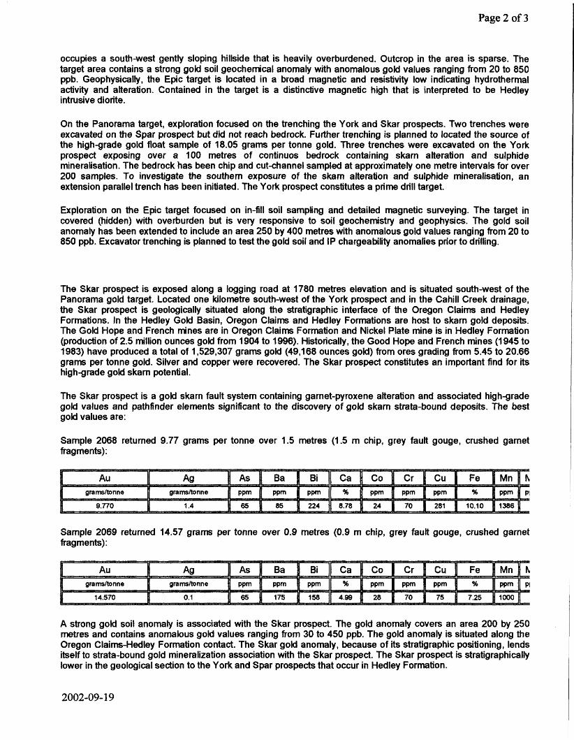
The Skar prospect is a gold skarn fault system containing garnet-pyroxene alteration and associated high-grade gold values and pathfinder elements significant to the discovery of gold skarn strata-bound deposits. The best gold values are:
Sample 2068 returned 9.77 grams per tonne over 1.5 metres (1.5 m chip, grey fault gouge, crushed garnet fragments):
Au Ag Bi Ca Co Cr grams/tonne
9.770
grams/tonne ppm ppm ppm % 1.4 65 85 224 8.78
ppm ppm ppm
24 70 281 J. % {} ppm [| p|
10.10 fl 1386
Sample 2069 returned 14.57 grams per tonne over 0.9 metres (0.9 m chip, grey fault gouge, crushed garnet fragments):
Au Ag As I Ba 1 Bi Ca Co Cr | Cu Fe ...
Mn N grams/tonne grams/tonne ppm 1 ppm | ppm % ppm ppm | Ppm % ppm PI
| 14.570 0.1 65 I 175 Q 158 4.99 28 70 | 75 7.25 1000
A strong gold soil anomaly is associated with the Skar prospect. The gold anomaly covers an area 200 by 250 metres and contains anomalous gold values ranging from 30 to 450 ppb. The gold anomaly is situated along the Oregon Claims-Hedley Formation contact. The Skar gold anomaly, because of its stratigraphic positioning, lends itself to strata-bound gold mineralization association with the Skar prospect. The Skar prospect is stratigraphically lower in the geological section to the York and Spar prospects that occur in Hedley Formation.
2002-09-19
Page 3 of 3
The Tower prospect (new find) is located south-west of the Panorama target and is approximately 500 metres from the York prospect. The Tower prospect is situated on the south-east slope of Panorama Ridge on the Winters Creek side. Old hand pits were found containing skarn alteration and sulphide mineralization. A grab sample of skarn sulphide mineralisation returned 0.310 grams per tonne gold and 1.1 grams per tonne silver along with anomalous bismuth, cobalt, chrome and copper. The gold soil anomaly associated with the Tower prospect covers an area of 200 by 300 metres with anomalous gold values ranging from 50 to 740 ppb. Cut-channel sampling is planned.
Goldcliff, based on the discovery of anomalous gold values in stream sediments, has staked additional claims for its own account. A regional stream silt program (14 samples) resulted in discovering anomalous gold values of high significance. Access to the region is provided along new logging roads. Additional mineral claims have been added to Goldcliffs holdings in the Hedley Gold Basin to bring the total Panorama Ridge mineral land holdings to approximately 3,750 hectares (9,300 acres).
Work in progress on the Panorama Ridge property consists of excavator trenching on the Panorama and Epic gold targets, cut-channel sampling, detailed geological mapping and drill tendering. Trenching on the Nordic prospect is pending the completion of logging activities in late September. The Tower prospect will be cut-channel sampled. Drilling is planned for later in the field season as follow-up to the detail work required to establish drill targets. Core drill tenders have been let to F. Boisvenu Drilling Ltd. (Delta) and Connors Drilling Ltd. (Kamloops). The analytical work is being conducted by Eco-Tech Laboratories Ltd. in Kamloops, BC. Samples are in for assay.
GOLDCLIFF RESOURCE CORPORATION
Per: "Leonard W. Saleken"
Leonard W. Saleken, PGeo
CEO, President, Director
The TSX Venture Exchange has not reviewed and does not accept responsibility
for the adequacy or accuracy of the contents of this news release.
gcnnews2219
2002-09-19

Schroeter, Tom EM:EX
From: Leonard W. Saleken [[email protected]] Sent: Friday, January 17, 2003 1:52 PM To: GokJcliff Subject: Goldcliffs new Triassic gold discovery (Castle Target) at Hedley
GOLDCLIFF RESOURCE CORPORATION, Suite 920-470 Granville Street, Vancouver, BC, Canada V6C
1V5
Tel: (604) 685-5685 Fax: ( 604) 685-5686 Email: [email protected] Web: www.goldcliff.com
GCN.TSXV (Trading SymboI.Exchange) & USA Exemption 12g3-2b:82-2748
NEWS RELEASE JANUARY 17. 2003
TRIASSIC GOLD AT CASTLE TARGET GOLDCLIFF RESOURCE CORPORATION (GCN.TSXV) discovers a new Triassic gold strata-bound target at Hedley. The Castle target reports 2.24 grams per tonne in strongly altered sediments containing abundant amounts of pyroxene-garnet skarn and pyrrhotite. The Castle target is located south of the Panorama gold target on the Panorama Ridge gold property. Goldcliffs Panorama Ridge gold property is located in the Hedley Gold Basin, Nickel Plate Mining District, Osoyoos Mining Division, British Colombia, Canada. The Hedley Gold Basin is a world-class gold producer of 2.5 million ounces gold.
The Castle target is the third major gold target discovery by GokJcliff on the Panorama Ridge property. The other two are the Epic and Panorama. The Panorama target has been the focus of Goldcliffs 2002 exploration program. The Castle target was identified by soil sampling. The soil anomaly is strongly anomalous in gold values that range from 30 to 740 ppb. The Castle target anomalous gold area is extensive and covers an area approximately 1000 metres by 1000 metres.
On the Castle target, GokJcliff has identified one gold skarn prospect, the Tower. The Tower consists of four small outcrops that were channel sampled. The best gold value is 1.00 metre containing 2.240 grams per tonne. The Tower gold values are summarized as follows:
CASTLE TARGET GOLD ZONE GOLD GRADES
Prospect Trench Metres Metres Feet Grams /Tonne Ounces(troy)/Ton
TOWER TW-01
0-27.35 27.35 89.71 0.418 0.012 He
TOWER TW-01 includes 7.30 23.94 0.924 0.027 He TOWER TW-01
includes 2.00 6.56 1.735 0.050 He
TOWER TW-02 0-27.70 27.70 90.86 0.394 0.011 He
TOWER TW-02 includes 3.50 11.48 0.731 0.021 He
TOWER TW-03 0-3.70 3.70 [ ™ 0.209 0.006 He
TOWER TW-04 0-28.70 28.70 I 94.14 0.188 0.005 He
TOWER TW-04 includes 4.40 l 14.43 0.371 0.011 He
Page 1 of2
2003-01-17
Page 2 of2
Conversions | 1.00 m ■ 3.28 ft I 1.00 grams/tonne = 0.029 ounces(troy)/ton
Tower prospect is located on the south eastern slope of Panorama Ridge within the^Winters__CEfifik drainage at an elevation of 1800 metres above sea level. The Tower outcrops are associated with a strong magnetic high and a moderate IP chargeability response. The geology is Triassic Hedley Formation sediments that are strongly skarn altered with abundant amounts of pyroxene-garnet skarn and pyrrhotite. The Tower gold zone strikes north-west and dips at shallow angles to the west. The gold mineralization is associated with the pathfinder elements of arsenic, bismuth, cobalt, chrome, copper, iron and tellurium.
The geological, geochemical and geophysical signature at the Tower prospect is consistent with Hedley gold skarn deposits.
The Tower prospect sample intervals average 0.86 metres per sample and range from 0.15 to 1.30 metres per sample. The samples intervals are continuous channel-chip samples that were cut by diamond saw. The samples were prepared and analysed by Eco-Tech Laboratory Ltd. under the supervision of a BC Certified Assayer (Jutta Je a louse). The Tower prospect detailed gold sampled results, statistical analysis and location map are posted on Goldcliffs website (www.goldcliff.com).
The Tower prospect is one of several gold skarn prospects associated with the Panorama Ridge gold property. Goldcliffs Panorama Ridge property is located 3.5 kilometres east of the Nickel Plate mine. At the Nickel Plate mine, the underground ore bodies are associated with a gold skarn mineralized zone that extends over a strike length of 300 metres (east-west) within a gold-bearing geological stratigraphic section of 100 metres. Within this gold stratigraphic section, the Nickel Plate underground ore bodies display a "cigar-shape" with a thickness ranging form 3 to 15 metres. The gold ore zones underground averaged 13.94 grams/tonne gold (0.40 ounces (troy)Aon) and produced 1.5 million ounces gold from 1904 to 1955. In 1986, Mascot Gold Mines re-engineered the gold resources of the old Nickel Plate underground mine and developed an open pit mining operation. The Nickel Plate open pit mine produced 1.0 million ounces gold from gold skarn ore bodies that averaged 1.98 grams/tonne gold (0.06 ounces(troy)/ton). The Nickel Plate mine closed in 1996. The Nickel Plate mine is owned by Barrick Gold Corporation.
The Panorama Ridge gold property is located 320 kilometres east of Vancouver in the Province of British Columbia, Canada. Hedley, the historic gold mining town in the Hedley Gold basin, is the centre of Goldcliffs exploration activities. Goldcliffs mineral claim holdings total 160 claim units covering approximately 4000 contiguous hectares (9880 acres). The claims are 100 per cent beneficially owned and operated by Goldcliff Resource Corporation.
GOLDCLIFF RESOURCE CORPORATION
Per: Leonard W. Saleken, PGeo
CEO, President, Director
The TSX Venture Exchange has not reviewed and does not accept responsibility
for the adequacy or accuracy of the contents of this news release.
gcnnews2301
2003-01-17
Page 1 of2
Schroeter, Tom EM:EX
From: Saleken [[email protected]] Sent: Tuesday, November 04, 2003 4:42 PM
To: Goldcliff Cc: Leonard W Saleken Subject: GOLDCLIFF-TOWER SURFACE GOLD RESULTS IMPRESSIVE
GOLDCLIFF RESOURCE CORPORATION, Suite 920 - 470 Granville Street, Vancouver, BC, Canada V6C
1V5
Tel: (604) 685-5685 Fax: ( 604) 261-8994 Email: [email protected] Web: www.goldcliff.com
Trading GCN.TSX-V & USA Exemption 12g3-2b:82-2748
NEWS RELEASE PANORAMA RIDGE PROJECT NOVEMBER 04, 2003
TOWER SURFACE TRENCH GOLD RESULTS IMPRESSIVE (Vancouver, Canada) Leonard W. Saleken, President of Goldcliff Resource Corporation, is pleased to announce that the Tower surface trenching unearthed 6.230 grams per tonne gold in a measured section of 5.0 metres averaging 2.190 grams per tonne gold. These significant gold values, along with strongly anomalous pathfinder elements (in particular, arsenic) at the main Tower showing, represent geological findings similar to those of the original Nickel Plate ore system, which was discovered in 1898 and placed into production in 1904.
The Tower prospect occurs within the Castle gold zone target area, measuring 1000 by 1000 metres on surface. The Tower prospect was re-discovered in 2001 by Goldcliff, and the original hand-pits probably date back to the early 1900s. The Tower prospect has been traced by prospecting and trenching for 200 metres on surface, along a north-east trend. The Tower prospect is situated in a highly anomalous magnetic-high zone that covers a surface area of some 120 by 300 metres. The 2003 surface trenching on the main Tower showing has exposed mineralization for over 100 metres in an east-west direction. This east-west direction is interpreted to represent a semi-vertical geological section of stratified skarn-altered sediments of the Hedley Formation. The sediments dip westerly at 30 to 35 degrees and strike north-easterly at 40 to 45 degrees. The section is cut by non-mineralized dykes of the Cahill granodiorite.
The combined 2001 and 2003 trenching at the main Tower showing has uncovered 77.00 metres of favourable gold-host rock in skarn-altered and sulphide-enriched sediments. The mineralized zone averages 0.511 grams per tonne gold. Within the 77.00 metres, a measured 9.00 metre section averages 1.585 grams per tonne that includes 5.0 metres of 2.190 grams per tonne gold. The mineralized zone reports several higher-grade gold values over 1.00 metres intervals that include 2.440, 3.420 and 6.230 grams per tonne gold.
The gold results within the Castle gold zone target area, particularly in the main Tower showing, are impressive. They elevate the Tower prospect to a high-priority status on the Panorama Ridge gold property. These gold values at the Tower prospect establish a second area of continuos gold mineralization and a separate area of gold zone potential. The York prospect, located on the Panorama gold zone, represents the first continuous gold mineralization located on the property. In 2002, continuous gold mineralization was discovered over measured width of 89.93 metres that contains 0.59 grams per tonne gold and includes 22.00 metres of 1.26 grams per tonne gold. The Tower and the York prospects are situated 500 metres apart from each other.
The Panorama Ridge gold property is located in the Hedley Gold Basin, which covers an area of approximately 500 square kilometres of favourable gold geology. Goldcliffs gold property is located in the northern portion of Hedley Gold Basin, Osoyoos Mining Division, near Hedley, BC, Canada. Goldcliffs property was discovered in year 2000 off new logging roads. Goldcliffs Panorama gold property is four kilometres east of the Nickel Plate mine. The Nickel Plate mine produced 2.5 million ounces of gold from underground and surface gold ore deposits
2003-11-04
Page 2 of2
mined from 1904 to 1996. The underground gold ore deposits recovered an averaged gold grade of 13.94 grams per tonne gold (0.407 ounces per ton) and the surface gold ore deposits recovered an averaged gold grade of 1.98 grams per tonne gold (0.058 ounce per ton). Goldcliffs Panorama Ridge gold property has similarities to the district gold producer - the Nickel Plate mine.
The drilling phase of Goldcliffs 2003 exploration programme is well underway. Drilling commenced on the York prospect in mid-October and is shortly scheduled for the Tower prospect. In total, 2000 metres of drilling is to be completed by year-end.
GOLDCLIFF RESOURCE CORPORATION
Per: "Leonard W. Saleken"
Leonard W. Saleken, PGeo
CEO, President, Director
The TSX Venture Exchange has not reviewed and does not accept responsibility
for the adequacy or accuracy of the contents of this news release.
gcnnews2326
2003-11-04
Page 1 of2
Schroeter, Tom EM:EX
w-jJfr^y
From: Saleken [[email protected]] Sent: Wednesday, July 21, 2004 3:17 PM
To: Goldcliff Subject: Goldcliffs Panorama Ridge 2004 Exploration Underway
GOLDCLIFF RESOURCE CORPORATION, Suite 920 - 470 Granville Street, Vancouver, BC, Canada V6C 1V5
Tel: (604) 685-5685 Fax:(604)261-8994 Email: [email protected] Web: www.goldcliff.com GCN.TSX-V (Trading SymboI.Exchange) & USA Exemption 12g3-2b:82-2748
NEWS RELEASE JULY 21, 2004 PANORAMA RIDGE 2004 EXPLORATION UNDERWAY
Leonard W. Saleken, President of Goldcliff Resource Corporation, is pleased to report that the 2004 exploration program is underway at the Company's 100% owned Panorama Ridge property. The 2004 program consists of soil sampling, trenching, mapping, and site preparation ahead of a minimum of 2000 metres of diamond drilling. This program is a follow up to the highly successful 2003 drill campaign. The surface work currently in progress will optimize the 2004 drill locations. Panorama Ridge is in the Hedley Gold Basin, near Hedley, B.C., and located a few kilometers east of the Nickel Plate gold mine which recovered 2,500,000 ounces gold from underground and open pit mining. Wide spaced drilling conducted by Goldcliff in 2003 demonstrates similar geology, mineralization and gold grade between Nickel Plate and Panorama Ridge. The drilling in 2003 was designed to test several zones within Panorama Ridge where targets were developed by geology, geochemistry and geophysics. The York, Viking, Thor, Tower and Nordic targets were tested. A NW-SE fence of holes appears to connect the York and Viking targets and establishes a broad zone of potential economic interest. Holes 23003, 23004, 23005 and 23006 all returned significant lengths of mineralization exceeding 1.0 g/t and each hole contains higher grade intervals over 2.00 g/t. The 2004 drilling will initially focus on confirming and expanding this zone. The significant drill results for the York and Viking are summarized in the table below: York Zone Hole Hole Hole Metre Interval Interval Gold Drill Hole # Length (m) Angle (-') Direction f ] From To Length (m) g/t 23003 123.75 065 321W 4.88 - 73.40 68.52 1.01 includes - - - 45.18 - 63.18 18.00 2.04 and - - - 52.18 - 57.18 5.00 3.80 23004 135.94 045 142W 24.21 - 72.21 48.00 1.01 Includes - - - 24.21 - 41.21 17.00 1.50 And - - - 25.21 - 30.21 5.00 2.78
Viking Zone Hole Hole Hole Metre Interval Interval Gold Drill Hole # Length (m) Angle (-0) Direction ("] From To Length (m) g/t 23005 113.08 065 316W 4.66 - 69.41 64.75 1.00 includes - - - 8.66 - 26.91 18.25 1.50 and - - - 8.66 - 13.66 5.00 1.79 23006 126.80 060 136E 4.66 - 19.66 15.00 1.02 includes - - - 4.66 - 14.66 10.00 1.34 and - - - 5.66 - 10.66 5.00 2.16 Drilling of the other targets confirmed the geologic model and established a substantial gold mineralized system throughout Panorama Ridge. The significant drill results for the other target areas are summarized in the table below.
Thor Zone Hole Hole Hole Metre Interval Interval Gold Drill Hole # Length (m) Angle (-") Direction (°) From - To Length (m) g/t 23009 102.41 045 090E 22.72 - 27.72 5.00 1.04
2004-07-21
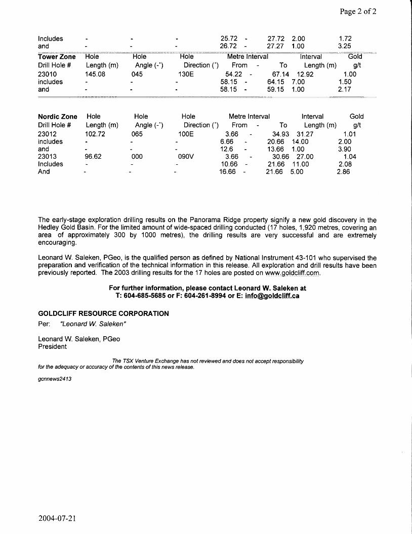
Page 2 of2
Includes - - - 25.72 - 27.72 2.00 1.72 and - - - 26.72 - 27.27 1.00 3.25 Tower Zone Hole Hole Hole Metre Interval Interval Gold Drill Hole # Length (m) Angle (-') Direction (°) From - To Length (nr i) g/t 23010 145.08 045 130E 54.22 - 67.14 12.92 1.00 includes - - - 58.15 - 64.15 7.00 1.50 and - - - 58.15 - 59.15 1.00 2.17
Nordic Zone Hole Hole Hole Metre Interval Interval Gold Drill Hole # Length (m) Angle (-*) Direction (') From - To Length (nr i) g/t 23012 102.72 065 100E 3.66 - 34.93 31.27 1.01 includes - - - 6.66 - 20.66 14.00 2.00 and - - - 12.6 - 13.66 1.00 3.90 23013 96.62 000 090V 3.66 - 30.66 27.00 1.04 Includes - - - 10.66 - 21.66 11.00 2.08 And - - - 16.66 - 21.66 5.00 2.86
The early-stage exploration drilling results on the Panorama Ridge property signify a new gold discovery in the Hedley Gold Basin. For the limited amount of wide-spaced drilling conducted (17 holes, 1,920 metres, covering an area of approximately 300 by 1000 metres), the drilling results are very successful and are extremely encouraging.
Leonard W. Saleken, PGeo, is the qualified person as defined by National Instrument 43-101 who supervised the preparation and verification of the technical information in this release. All exploration and drill results have been previously reported. The 2003 drilling results for the 17 holes are posted on www^oycjjftcom.
For further information, please contact Leonard W. Saleken at T: 604-685-5685 or F: 604-261-8994 or E: [email protected]
GOLDCLIFF RESOURCE CORPORATION Per: "Leonard W. Saleken"
Leonard W. Saleken, PGeo President
The TSX Venture Exchange has not reviewed and does not accept responsibility for the adequacy or accuracy of the contents of this news release.
gcnnews2413
2004-07-21
Schroeter, Tom EM:EX
From: Saleken [[email protected]] Sent: Tuesday, October 19, 2004 9:18 AM
To: Goldcliff Subject: GCNNew2420-PANORAMA DRILLING IN PROGRESS
GOLDCLIFF RESOURCE CORPORATION, Suite 920 - 470 Granville Street, Vancouver, BC, Canada V6C 1V5
Tel: (604) 685-5685 Fax: (604) 261-8994 Email: [email protected] Web: www.goldcliff.com GCN.TSX-V (Trading SymboI.Exchange) & USA Exemption 12g3-2b:82-2748
NEWS RELEASE October 18, 2004
PANORAMA RIDGE - EXPLORATION PROGRESS REPORT (Vancouver, Canada), Leonard W. Saleken, President of Goldcliff Resource Corporation, reports that the 2004 drilling program is in progress at the Company's 100% owned Panorama Ridge gold property, Hedley Gold Basin, BC. Based on the very successful exploration results of 2003 and the follow-up 2004 surface trenching gold results, Goldcliff has commenced the 2004 core drilling program. The first several drill holes in the 2004 drilling program will explore the depth potential of the gold mineralization found in the 2003 drilling and the 2004 surface trenching between the York and Viking prospects (York-Viking gold zone). Additional 2004 drill holes will test the extension of gold mineralization in the vicinity of the Nordic prospect. The final drill holes will investigate the highly anomalous gold soil values and the widespread geophysical anomaly in the Epic prospect area.
This year's initial York-Viking gold zone trenching (mentioned above) has discovered 1.129 grams/tonne (g/t) gold in bedrock over a continuous surface length of 77.00 metres. These new 2004 gold results have significantly expanded the surface gold mineralization between the York and Viking prospects. Results from the surface York-Viking trench sampling (previously reported) are summarized as follows:
Total Length (m) From (m) To (m) Interval (m) Gold (g/t) 77.00 0.00 77.00 77.00 1.129 Includes 25.00 59.00 34.00 1.507 and 37.00 59.00 22.00 1.730 and 43.00 50.00 7.00 2.037 and 48.00 50.00 2.00 2.645
The York-Viking gold zone 2003 drilling program was very successful. Five core holes that were drilled on a NW-SE geological section intersected the favourable Hedley Gold Basin gold skarn mineralized sedimentary horizon and indicated the presence of a potentially economic gold deposit.
The 2004 exploration surface results at the new York-Viking gold mineralized zone are very encouraging. Goldcliffs exploration model is a sedex-strata-bound gold deposit model. The Nickel Plate-Mascot gold deposits, which produced 2.5 million ounces of gold, are geologically similar to the Panorama Ridge gold mineralization. The Nickel Plate-Mascot gold mine is located a few kilometers west of Panorama Ridge. Goldcliffs drilling in 2003 confirmed potentially economic gold grades to depths of greater than 100 metres. The goal of the 2004 exploration drilling program now underway is to further increase the size of the known gold mineralized areas and to confirm additional regions of significant subsurface gold mineralization on the Panorama Ridge property. Leonard W. Saleken, PGeo, is the qualified person as defined by National Instrument 43-101 who supervised the preparation and verification of the technical information in this release.
For further information, please contact Leonard W. Saleken at T: 604-685-5685 or F: 604-261-8994 or E: [email protected]
Toll Free: 1-866-769^802 Web: www.goldcliff.cpm
2004-11-03
Page 1 of2
Schroeter, Tom EM:EX ^J^^/mi^^
From: Saleken [[email protected]] ' V ' Sent: Monday, November 15, 2004 10:58 AM To: Goldcliff Subject: GOLDCLIFF COMPLETES 2004 DRILLING PROGRAM
NEWSJRELEASE November 15, 2004
PANORAMA RIDGE -2004 DRILLING COMPLETED (Vancouver, Canada), Leonard W. Saleken, President of Goldcliff Resource Corporation, reports that the 2004 drilling program has been completed at the Company's 100%-owned Panorama Ridge gold property, Hedley Gold Basin, BC. The Company completed 22 core holes totalling 2,276.59 metres. The drilling depth ranged from 52.57 to 150.67 metres, for an average drilling depth of 103.48 metres. The drilling on the property for 2003 and 2004 totals 39 core holes and 4,196.91 metres. Of the several gold targets identified on Panorama Ridge gold property for exploration drilling, Goldcliffs 2004 drilling has focused on the York-Viking gold zone, the Nordic prospect and the Epic gold target zone.
Within the York-Viking gold zone, twelve holes were drilled in 2004, for a total of 1,269.11 metres, bringing the drilling totals for 2003 and 2004 to 18 holes and 1,947.38 metres. The average depth of drilling comes to 108.19 metres in the York-Viking gold zone. The 2004 drill program was a follow-up to the 2003 drilling results of potentially-economic gold grades encountered in six drill holes in 2003 (Cross Section10,000N). The 2004 drilling pattern is designed to provide geological information and to expand the gold-grade potential in a north-south and east-west direction in the York-Viking gold zone. The surface gold mineralization indicates the York-Viking gold zone covers an area approximately 300 by 300 metres, and the 2003 drilling indicates that gold mineralization extends to depths greater than 100 metres. The 2004 drilling pattern and drill hole spacing will provide Goldcliff with a preliminary assessment of the economic gold potential of the York-Viking gold zone.
At the Nordic prospect, six holes were drilled in 2004, for a total of 557.00 metres, bringing the drilling totals for 2003 and 2004 to 11 holes and 1,057.17 metres. The average depth of drilling for both years comes to 96.11 metres. The 2003 drilling results were very encouraging. The mineralized gold zone (GMZ) along the Nordic gold trend was intersected in all five 2003 drill holes with widespread gold values of 0.47 grams/tonne (g/t) occurring over 92.96 metres. The potential economic gold grades of 1.35 g/t gold and 1.11 g/t gold occur over 23.27 metres and 25.00 metres, respectively, in two drill holes. The 2004 drill program was designed to evaluate the geological characteristics and the nature of the gold mineralization as well as expand the GMZ and known occurrences of potential economic gold grades at the Nordic prospect.
At the Epic gold target zone, four holes were drilled in 2004 for a total of 450.48 metres. The average depth of drilling comes to 112.62 metres. The 2004 drill program was designed to evaluate the coincidental-large gold soil geochemical and strong IP ( high sulphide) anomalies. The Epic gold target area contains no rock outcrop and is entirely covered by glacial overburden. The anomalous Epic gold target area occurs over a surface area of approximately 500 by 500 metres and is located in the northwest region of the Panorama Ridge property.
Goldcliffs exploration model for the Panorama Ridge gold property in the Hedley Gold Basin is a sedex-strata-bound gold deposit model. The Nickel Plate-Mascot gold deposits, which produced 2.5 million ounces of gold, are geologically similar to the Panorama Ridge gold mineralization. The Nickel Plate-Mascot gold mine is located a few kilometers west of Panorama Ridge. Goldcliffs drilling in 2003 confirmed potentially economic gold grades to depths greater than 100 metres. The goal of the 2004 exploration drilling program is to further increase the size of the known gold mineralized areas and to confirm additional regions of significant subsurface gold mineralization on the Panorama Ridge property. Leonard W. Saleken, PGeo, is the qualified person as defined by National Instrument 43-101 who supervised the preparation and verification of the technical information in this release.
For further information, please contact Leonard W. Saleken at T: 604-685-5685 or F: 604-261-8994 or E: [email protected]
Toll Free: 1-866-769-4802 Web: www^gpldcliffxom
2004-11-15