Embed Size (px)
Citation preview
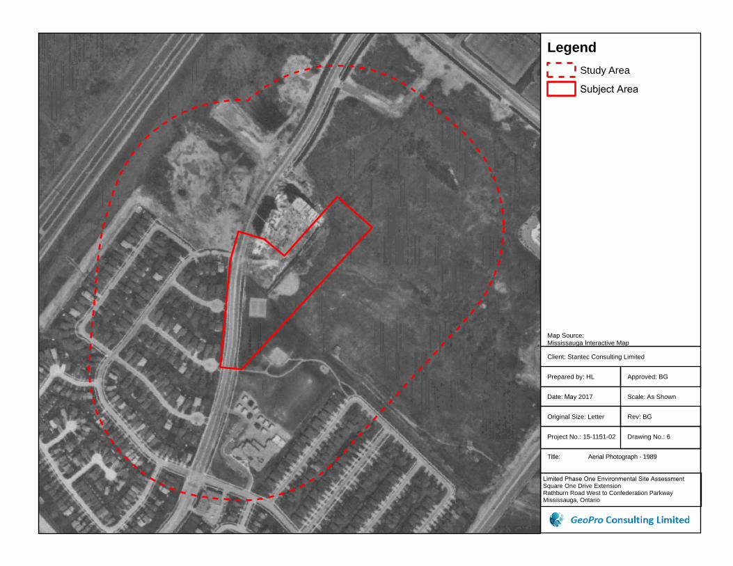
Client: Stantec Consulting Limited
Prepared by: HL
Date: May 2017
Original Size: Letter
Project No.: 15-1151-02
Title: Aerial Photograph - 1989
Limited Phase One Environmental Site Assessment Square One Drive Extension Rathburn Road West to Confederation Parkway Mississauga, Ontario
Rev: BG
Drawing No.: 6
Approved: BG
Scale: As Shown
Map Source:Mississauga Interactive Map
LegendStudy Area
Subject Area

Client: Stantec Consulting Limited
Prepared by: HL
Date: May 2017
Original Size: Letter
Project No.: 15-1151-02
Title: Aerial Photograph - 1997
Limited Phase One Environmental Site Assessment Square One Drive Extension Rathburn Road West to Confederation Parkway Mississauga, Ontario
Rev: BG
Drawing No.: 7
Approved: BG
Scale: As Shown
Map Source:Mississauga Interactive Map
LegendStudy Area
Subject Area

Client: Stantec Consulting Limited
Prepared by: HL
Date: May 2017
Original Size: Letter
Project No.: 15-1151-02
Title: Aerial Photograph - 2002
Limited Phase One Environmental Site AssessmentSquare One Drive Extension Rathburn Road West to Confederation Parkway Mississauga, Ontario
Rev: BG
Drawing No.: 8
Approved: BG
Scale: As Shown
Map Source:Mississauga Interactive Map
LegendStudy Area
Subject Area

Client: Stantec Consulting Limited
Prepared by: HL
Date: May 2017
Original Size: Letter
Project No.: 15-1151-02
Title: Aerial Photograph - 2007
Limited Phase One Environmental Site Assessment Square One Drive Extension Rathburn Road West to Confederation Parkway Mississauga, Ontario
Rev: BG
Drawing No.: 9
Approved: BG
Scale: As Shown
Map Source:Mississauga Interactive Map
LegendStudy Area
Subject Area

Client: Stantec Consulting Limited
Prepared by: HL
Date: May 2017
Original Size: Letter
Project No.: 15-1151-02
Title: Aerial Photograph - 2016
Limited Phase One Environmental Site Assessment Square One Drive Extension Rathburn Road West to Confederation Parkway Mississauga, Ontario
Rev: BG
Drawing No.: 10
Approved: BG
Scale: As Shown
Map Source:Mississauga Interactive Map
LegendStudy Area
Subject Area

Client: Stantec Consulting Limited
Prepared by: HL
Date: May 2017
Original Size: Letter
Project No.: 15-1151-02
Title: Topographical Map
Limited Phase One Environmental Site Assessment Square One Drive Extension Rathburn Road West to Confederation Parkway Mississauga, Ontario
Rev: BG
Drawing No.: 11
Approved: BG
Scale: As Shown
Map Source:Atlas of Canada - Toporama
0 130 260 390 52065Meters
®Legend
Subject Area
Study Area

APPENDIX A

Project Property: Rathburn Road and Confederation Pkwy41752 Confederation Pky Mississauga ON L5B0G4
Project No: 15-1151
Report Type: Quote - Custom-Build Your Own Report
Order No: 20161222086
Requested by: GeoPro Consulting Limited
Date Completed: December 29, 2016

2 erisinfo.com | Environmental Risk Information Services Order No: 20161222086
h-Table of Contents
Notice: IMPORTANT LIMITATIONS and YOUR LIABILITY
Reliance on information in Report: This report DOES NOT replace a full Phase I Environmental Site Assessment but is solely intended to be used asa database review of environmental records.
License for use of information in Report: No page of this report can be used without this cover page, this notice and the project property identifier.The information in Report(s) may not be modified or re-sold.
Your Liability for misuse: Using this Service and/or its reports in a manner contrary to this Notice or your agreement will be in breach of copyright andcontract and ERIS may obtain damages for such mis-use, including damages caused to third parties, and gives ERIS the right to terminate your account,rescind your license to any previous reports and to bar you from future use of the Service.
No warranty of Accuracy or Liability for ERIS: The information contained in this report has been produced by EcoLog Environmental Risk InformationServices Ltd ("ERIS") using various sources of information, including information provided by Federal and Provincial government departments. Thereport applies only to the address and up to the date specified on the cover of this report, and any alterations or deviation from this description willrequire a new report. This report and the data contained herein does not purport to be and does not constitute a guarantee of the accuracy of theinformation contained herein and does not constitute a legal opinion nor medical advice. Although ERIS has endeavored to present you with informationthat is accurate, ERIS disclaims, any and all liability for any errors, omissions, or inaccuracies in such information and data, whether attributable toinadvertence, negligence or otherwise, and for any consequences arising therefrom. Liability on the part of ERIS is limited to the monetary value paid forthis report.
Trademark and Copyright: You may not use the ERIS trademarks or attribute any work to ERIS other than as outlined above. This Service andReport(s) are protected by copyright owned by EcoLog ERIS Ltd. Copyright in data used in the Service or Report(s) (the "Data") is owned by ERIS or itslicensors. The Service, Report(s) and Data may not be copied or reproduced in whole or in any substantial part without prior written consent of ERIS.
Table of Contents
Table of Contents...........................................................................................2Executive Summary........................................................................................3 Executive Summary: Report Summary.......................................................................................................................4
Executive Summary: Site Report Summary - Project Property...................................................................................6
Executive Summary: Site Report Summary - Surrounding Properties........................................................................7
Executive Summary: Summary By Data Source.........................................................................................................8
Map...............................................................................................................10Aerial.............................................................................................................11Topographic Map..........................................................................................12Detail Report.................................................................................................13Unplottable Summary...................................................................................18Unplottable Report........................................................................................20Appendix: Database Descriptions.................................................................31Definitions.....................................................................................................39

3 erisinfo.com | Environmental Risk Information Services Order No: 20161222086
h-Executive Summary
Property Information:
Project Property: Rathburn Road and Confederation Pkwy41752 Confederation Pky Mississauga ON L5B0G4
Project No: 15-1151
Order Information:
Order No: 20161222086 Date Requested: December 22, 2016 Requested by: GeoPro Consulting Limited Report Type: Quote - Custom-Build Your Own Report
Additional Products:
Executive Summary
4 erisinfo.com | Environmental Risk Information Services Order No: 20161222086
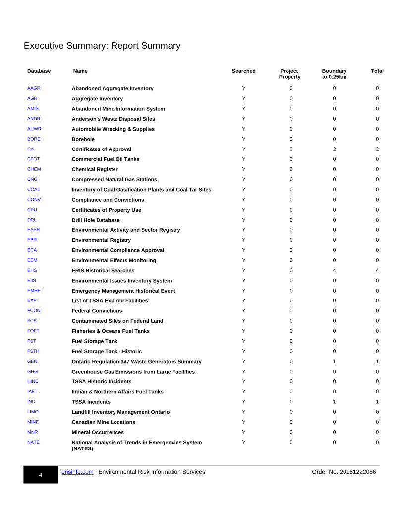
h-Executive Summary: Report Summary
Database Name Searched Project Property
Boundaryto 0.25km
Total
rr-AAGR-aa
Abandoned Aggregate Inventory Y 0 0 0rr-AGR-aa
Aggregate Inventory Y 0 0 0rr-AMIS-aa
Abandoned Mine Information System Y 0 0 0rr-ANDR-aa
Anderson's Waste Disposal Sites Y 0 0 0rr-AUWR-aa
Automobile Wrecking & Supplies Y 0 0 0rr-BORE-aa
Borehole Y 0 0 0rr-CA-aa
Certificates of Approval Y 0 2 2rr-CFOT-aa
Commercial Fuel Oil Tanks Y 0 0 0rr-CHEM-aa
Chemical Register Y 0 0 0rr-CNG-aa
Compressed Natural Gas Stations Y 0 0 0rr-COAL-aa
Inventory of Coal Gasification Plants and Coal Tar Sites Y 0 0 0rr-CONV-aa
Compliance and Convictions Y 0 0 0rr-CPU-aa
Certificates of Property Use Y 0 0 0rr-DRL-aa
Drill Hole Database Y 0 0 0rr-EASR-aa
Environmental Activity and Sector Registry Y 0 0 0rr-EBR-aa
Environmental Registry Y 0 0 0rr-ECA-aa
Environmental Compliance Approval Y 0 0 0rr-EEM-aa
Environmental Effects Monitoring Y 0 0 0rr-EHS-aa
ERIS Historical Searches Y 0 4 4rr-EIIS-aa
Environmental Issues Inventory System Y 0 0 0rr-EMHE-aa
Emergency Management Historical Event Y 0 0 0rr-EXP-aa
List of TSSA Expired Facilities Y 0 0 0rr-FCON-aa
Federal Convictions Y 0 0 0rr-FCS-aa
Contaminated Sites on Federal Land Y 0 0 0rr-FOFT-aa
Fisheries & Oceans Fuel Tanks Y 0 0 0rr-FST-aa
Fuel Storage Tank Y 0 0 0rr-FSTH-aa
Fuel Storage Tank - Historic Y 0 0 0rr-GEN-aa
Ontario Regulation 347 Waste Generators Summary Y 0 1 1rr-GHG-aa
Greenhouse Gas Emissions from Large Facilities Y 0 0 0rr-HINC-aa
TSSA Historic Incidents Y 0 0 0rr-IAFT-aa
Indian & Northern Affairs Fuel Tanks Y 0 0 0rr-INC-aa
TSSA Incidents Y 0 1 1rr-LIMO-aa
Landfill Inventory Management Ontario Y 0 0 0rr-MINE-aa
Canadian Mine Locations Y 0 0 0rr-MNR-aa
Mineral Occurrences Y 0 0 0rr-NATE-aa
National Analysis of Trends in Emergencies System (NATES)
Y 0 0 0
AAGR
AGR
AMIS
ANDR
AUWR
BORE
CA
CFOT
CHEM
CNG
COAL
CONV
CPU
DRL
EASR
EBR
ECA
EEM
EHS
EIIS
EMHE
EXP
FCON
FCS
FOFT
FST
FSTH
GEN
GHG
HINC
IAFT
INC
LIMO
MINE
MNR
NATE
Executive Summary: Report Summary

5 erisinfo.com | Environmental Risk Information Services Order No: 20161222086
Database Name Searched Project Property
Boundaryto 0.25km
Total
rr-NCPL-aa
Non-Compliance Reports Y 0 0 0rr-NDFT-aa
National Defense & Canadian Forces Fuel Tanks Y 0 0 0rr-NDSP-aa
National Defense & Canadian Forces Spills Y 0 0 0rr-NDWD-aa
National Defence & Canadian Forces Waste Disposal Sites
Y 0 0 0
rr-NEBW-aa
National Energy Board Wells Y 0 0 0rr-NEES-aa
National Environmental Emergencies System (NEES) Y 0 0 0rr-NPCB-aa
National PCB Inventory Y 0 0 0rr-NPRI-aa
National Pollutant Release Inventory Y 0 0 0rr-OGW-aa
Oil and Gas Wells Y 0 0 0rr-OOGW-aa
Ontario Oil and Gas Wells Y 0 0 0rr-OPCB-aa
Inventory of PCB Storage Sites Y 0 0 0rr-ORD-aa
Orders Y 0 0 0rr-PAP-aa
Canadian Pulp and Paper Y 0 0 0rr-PCFT-aa
Parks Canada Fuel Storage Tanks Y 0 0 0rr-PES-aa
Pesticide Register Y 0 0 0rr-PINC-aa
TSSA Pipeline Incidents Y 0 1 1rr-PRT-aa
Private and Retail Fuel Storage Tanks Y 0 0 0rr-PTTW-aa
Permit to Take Water Y 0 0 0rr-REC-aa
Ontario Regulation 347 Waste Receivers Summary Y 0 0 0rr-RSC-aa
Record of Site Condition Y 0 0 0rr-RST-aa
Retail Fuel Storage Tanks Y 0 0 0rr-SCT-aa
Scott's Manufacturing Directory Y 0 2 2rr-SPL-aa
Ontario Spills Y 0 1 1rr-SRDS-aa
Wastewater Discharger Registration Database Y 0 0 0rr-TANK-aa
Anderson's Storage Tanks Y 0 0 0rr-TCFT-aa
Transport Canada Fuel Storage Tanks Y 0 0 0rr-VAR-aa
TSSA Variances for Abandonment of Underground Storage Tanks
Y 0 0 0
rr-WDS-aa
Waste Disposal Sites - MOE CA Inventory Y 0 0 0rr-WDSH-aa
Waste Disposal Sites - MOE 1991 Historical Approval Inventory
Y 0 0 0
rr-WWIS-aa
Water Well Information System Y 0 0 0
Total: 0 12 12
NCPL
NDFT
NDSP
NDWD
NEBW
NEES
NPCB
NPRI
OGW
OOGW
OPCB
ORD
PAP
PCFT
PES
PINC
PRT
PTTW
REC
RSC
RST
SCT
SPL
SRDS
TANK
TCFT
VAR
WDS
WDSH
WWIS

6 erisinfo.com | Environmental Risk Information Services Order No: 20161222086
h-Executive Summary: Site Report Summary - Project Property
MapKey
DB Company/Site Name Address Dir/Dist (m) Elev diff (m)
Page Number
No records found in the selected databases for the project property.
Executive Summary: Site Report Summary - Project Property

7 erisinfo.com | Environmental Risk Information Services Order No: 20161222086
h-Executive Summary: Site Report Summary - Surrounding Properties
MapKey
DB Company/Site Name Address Dir/Dist (m) Elev Diff (m)
Page Number
m1ddd-GEN-850269725-aa
Enersource Hydro Mississauga Inc.
390 Rathburn Road West Mississauga ON L5B 3N8
S/22.3 -4.36p-13-850269725-x
m2ddd-SCT-803037633-aa
Marble & Granite Plus Inc. 350 Rathburn Rd W Suite 1705Mississauga ON L5B 3Y2
N/38.6 1.36p-13-803037633-x
m3ddd-SPL-803525852-aa
335 Rathburn Road West Mississauga ON L5B 0C8
NNW/86.1 -5.77p-13-803525852-x
m4ddd-CA-803743117-aa
Daniels CCW Corporation 388 Prince of Wales Dr Mississauga ON L5B 0A1
ENE/100.9 0.63p-14-803743117-x
m5ddd-EHS-849432749-aa
Living Arts Drive Mississauga ON
ENE/152.9 -3.52p-14-849432749-x
m6ddd-INC-848835443-aa
4188 LIVING ARTS DRIVE, MISSISSAUGA ON
NE/164.1 -2.83p-14-848835443-x
m7ddd-SCT-803825711-aa
Sykora & Associates 332 Wallenberg Cres Mississauga ON L5B 3M8
SSE/170.6 -7.68p-15-803825711-x
m8ddd-EHS-803132918-aa
4225 Living Arts Dr Mississauga ON
ESE/186.2 0.37p-15-803132918-x
m9ddd-CA-288316-aa
HAMMERSON PROPERTIES INC.
299,309,319&329 RATHBURN RD.W. MISSISSAUGA CITY ON
NNE/195.8 -3.57p-15-288316-x
m10ddd-EHS-803134433-aa
380 Princess Royal Drive Mississauga ON L5B 4M9
E/216.4 -16.23p-16-803134433-x
m11ddd-PINC-848611976-aa
LIVING ARTS DRIVE AND RATHBURN WEST, MISSISSAUGA ON
NNE/221.1 -0.51p-16-848611976-x
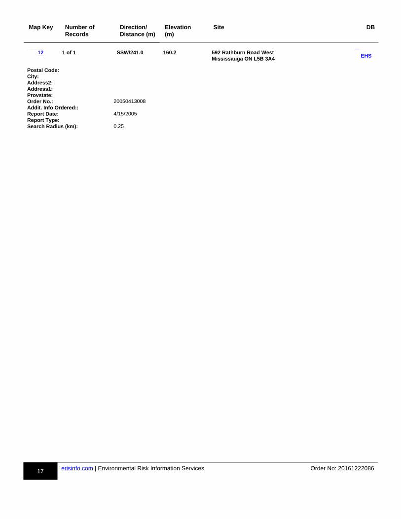
m12ddd-EHS-801796135-aa
592 Rathburn Road West Mississauga ON L5B 3A4
SSW/241.0 -0.61p-17-801796135-x
13
13
13
14
14
14
15
15
15
16
16
17
1
2
3
4
5
6
7
8
9
10
11
12
GEN
SCT
SPL
CA
EHS
INC
SCT
EHS
CA
EHS
PINC
EHS
Executive Summary: Site Report Summary - Surrounding Properties

8 erisinfo.com | Environmental Risk Information Services Order No: 20161222086
h-Executive Summary: Summary By Data Source
CA - Certificates of Approval
A search of the CA database, dated 1985-Oct 30, 2011* has found that there are 2 CA site(s) within approximately 0.25 kilometers of the project property.
Site Address Distance (m) Map Key
Daniels CCW Corporation 388 Prince of Wales Dr Mississauga ON L5B 0A1
100.9 m-4-803743117-a
HAMMERSON PROPERTIES INC. 299,309,319&329 RATHBURN RD.W. MISSISSAUGA CITY ON
195.8 m-9-288316-a
EHS - ERIS Historical Searches
A search of the EHS database, dated 1999-Aug 2016 has found that there are 4 EHS site(s) within approximately 0.25 kilometers of theproject property.
Site Address Distance (m) Map Key
Living Arts Drive Mississauga ON
152.9 m-5-849432749-a
4225 Living Arts Dr Mississauga ON
186.2 m-8-803132918-a
380 Princess Royal Drive Mississauga ON L5B 4M9
216.4 m-10-803134433-a
592 Rathburn Road West Mississauga ON L5B 3A4
241.0 m-12-801796135-a
GEN - Ontario Regulation 347 Waste Generators Summary
A search of the GEN database, dated 1986-Sep 2016 has found that there are 1 GEN site(s) within approximately 0.25 kilometers of the project property.
Site Address Distance (m) Map Key
Enersource Hydro Mississauga Inc. 390 Rathburn Road West Mississauga ON L5B 3N8
22.3 m-1-850269725-a
INC - TSSA Incidents
A search of the INC database, dated Oct 31, 2016 has found that there are 1 INC site(s) within approximately 0.25 kilometers of the project property.
4
9
5
8
10
12
1
Executive Summary: Summary By Data Source

9 erisinfo.com | Environmental Risk Information Services Order No: 20161222086
Site Address Distance (m) Map Key
4188 LIVING ARTS DRIVE, MISSISSAUGA ON
164.1 m-6-848835443-a
PINC - TSSA Pipeline Incidents
A search of the PINC database, dated Oct 31, 2016 has found that there are 1 PINC site(s) within approximately 0.25 kilometers of the project property.
Site Address Distance (m) Map Key
LIVING ARTS DRIVE AND RATHBURN WEST, MISSISSAUGA ON
221.1 m-11-848611976-a
SCT - Scott's Manufacturing Directory
A search of the SCT database, dated 1992-Mar 2011* has found that there are 2 SCT site(s) within approximately 0.25 kilometers of the project property.
Site Address Distance (m) Map Key
Marble & Granite Plus Inc. 350 Rathburn Rd W Suite 1705Mississauga ON L5B 3Y2
38.6 m-2-803037633-a
Sykora & Associates 332 Wallenberg Cres Mississauga ON L5B 3M8
170.6 m-7-803825711-a
SPL - Ontario Spills
A search of the SPL database, dated 1988-Jan 2016 has found that there are 1 SPL site(s) within approximately 0.25 kilometers of the project property.
Site Address Distance (m) Map Key
335 Rathburn Road West Mississauga ON L5B 0C8
86.1 m-3-803525852-a
6
11
2
7
3

#*
#*
#*
#*
#*
#*
#*#*
#*
#*
#*
#*
m9c
m8c
m7c
m6c
m5c
m4c
m3c
m2c
m1c
m12c
m11c
m10c
RATH
BURN
RD
W
ELORA DR
CONFEDERATION PKY
HIGHWAY 403
LIVING ARTS DR
PARKSIDE VILLAGE DR
PRINCE OF W
ALES DR
CENTR
E VIEW
DR
WALLENBERG CRES
BRICKSTONE MEWS
HAZINEH CRT
PARKVIEW BLV
D
GREENPARK CRES
PRINCESS ROYAL DR
ARBUTUS WAY
DUKE OF YORK BLVD
SCHNEIDER CRT
TURNBRIDGE RD
SUGAR
BUSH
RD
SQUARE 1 D
R
SQUIRE CRT
VIA RUSSO CRT
HIGHWAY 403
CONFEDERATION PKY
SUGARBUSH RD
79°39'W43
°35'
30"
N
43°3
5'3
0"N
Project Property
Buffer Outline
#* Eris Sites with Higher Elevation
") Eris Sites with Same Elevation
#*
Eris Sites with Lower Elevation
( Eris Sites with Unknown Elevation
Expressway
Principal Highway
Secondary Highway
Major Road
Local road
Trail
Proposed Road
Ferry Route/Ice Road
Industrial and Resource - Regions
Main Line
Sidetrack
Transit Line
Abandoned Line
National Park
Provincial or Territorial Park
Other Park
Golf Course or Driving Range
Park or Sports Field
Other Recreation Area
130 0 13065m
Order No: 20161222086
Map : 0.25 Kilometer Radius1:4600
Address: 41752 Confederation Pky, Mississauga, ON, L5B0G4
Source: © 2015 DMTI Spatial Inc. © Ecolog ERIS Ltd
9
8
7
6
5
4
3
2
1
12
11
10

Source: Esri, DigitalGlobe, GeoEye, Earthstar Geographics, CNES/AirbusDS, USDA, USGS, AeroGRID, IGN, and the GIS User Community
79°39'W
250 0 250125
m
Order No: 20161222086Aerial
1:10000
Address: 41752 Confederation Pky, Mississauga, ON, L5B0G4© Ecolog ERIS LtdSource: ESRI World Imagery

Sources: Esri, HERE, DeLorme, Intermap, increment P Corp., GEBCO,USGS, FAO, NPS, NRCAN, GeoBase, IGN, Kadaster NL, Ordnance Survey,Esri Japan, METI, Esri China (Hong Kong), swisstopo, MapmyIndia, ©OpenStreetMap contributors, and the GIS User Community
79°39'W
250 0 250125
m
Order No: 20161222086Topographic Map
1:10000
Address: 41752 Confederation Pky, Mississauga, ON, L5B0G4© Ecolog ERIS LtdSource: ESRI World Topographic Map

13 erisinfo.com | Environmental Risk Information Services Order No: 20161222086
h-Detail Report
Map Key Number of Records
Direction/Distance (m)
Elevation (m)
Site DB
m-1-850269725-b
1 of 1 S/22.3 156.5 Enersource Hydro Mississauga Inc.390 Rathburn Road West Mississauga ON L5B 3N8
dd-GEN-850269725-bbp-850269725-y
PO Box Num:Status: RegisteredCountry: CanadaGenerator #: ON8339541Approval Yrs:: As of Sep 2016SIC Code:SIC Description:
--Details--Waste Code: 112 CWaste Description: Acid solutions - containing heavy metals
m-2-803037633-b
1 of 1 N/38.6 162.2 Marble & Granite Plus Inc.350 Rathburn Rd W Suite 1705Mississauga ON L5B 3Y2
dd-SCT-803037633-bbp-803037633-y
Established: 01-AUG-03Plant Size (ft²):Employment:
--Details--Description: All Other Non-Metallic Mineral Product ManufacturingSIC/NAICS Code: 327990
Description: Other Specialty-Line Building Supplies Wholesaler-DistributorsSIC/NAICS Code: 416390
Description: All Other Non-Metallic Mineral Product ManufacturingSIC/NAICS Code: 327990
m-3-803525852-b
1 of 1 NNW/86.1 155.1 335 Rathburn Road West Mississauga ON L5B 0C8
dd-SPL-803525852-bbp-803525852-y
Ref NO: 2657-7X9JWBContaminant Code: 13Contaminant Name: FURNACE OILContaminant Quantity:Incident Cause::Incident Dt:Incident Reason::Incident Summary:: TSSA: Tank Leak - 335 Rathburn Road West, MississaugaMOE Reported Dt: 10/28/2009Environmental Impact:: ConfirmedNature of Impact:: Soil ContaminationReceiving Medium::SAC Action Class: Land SpillsSector Source Type: Other
1
2
3
GEN
SCT
SPL
Detail Report

14 erisinfo.com | Environmental Risk Information Services Order No: 20161222086
Map Key Number of Records
Direction/Distance (m)
Elevation (m)
Site DB
Site Municipality:
m-4-803743117-b
1 of 1 ENE/100.9 161.5 Daniels CCW Corporation 388 Prince of Wales Dr Mississauga ON L5B 0A1
dd-CA-803743117-bbp-803743117-y
Certificate #: 1641-7AMMEC Application Year: 2008Issue Date: 1/17/2008Approval Type: AirStatus: ApprovedApplication Type:Client Name::Client Address::Client City::Client Postal Code::Project Description::Contaminants::Emission Control::
m-5-849432749-b
1 of 1 ENE/152.9 157.3 Living Arts Drive Mississauga ON
dd-EHS-849432749-bbp-849432749-y
Postal Code:City: MississaugaAddress2:Address1: Living Arts DriveProvstate: ONOrder No.: 20160108029Addit. Info Ordered::Report Date: 14-JAN-16Report Type: Custom ReportSearch Radius (km): .25
m-6-848835443-b
1 of 1 NE/164.1 158.0 4188 LIVING ARTS DRIVE, MISSISSAUGA ON
dd-INC-848835443-bbp-848835443-y
Incident ID:Incident Number: 1841712Attribute Category: FS-Perform L1 Incident InspStatus Code:Incident Location: 4188 LIVING ARTS DRIVE, MISSISSAUGA - FIREDrainage System:Sub Surface Contam.:Aff. Prop. Use Water:Contam. Migrated:Contact Natural Env.:Near Body of Water:Approx. Quant. Rel.:Equipment Model:Serial No:Residential App. Type:Commercial App. Type:Industrial App. Type:Institutional App. Type:Venting Type:Vent Connector Mater.:Vent Chimney Mater.:Notes:Pipeline Type:
4
5
6
CA
EHS
INC

15 erisinfo.com | Environmental Risk Information Services Order No: 20161222086
Map Key Number of Records
Direction/Distance (m)
Elevation (m)
Site DB
Pipeline Involved:Pipe Material:Depth Ground Cover:Regulator Location:Regulator Type:Operation Pressure:Occurence Narrative: fire at back of grillLiquid Prop Make:Liquid Prop Model:Liquid Prop Serial No:Equipment Type:Cylinder Capacity:Cylinder Capac. Units:Cylinder Material Type:Tank Capacity:Tank Material Type:Tank Storage Type:Tank Location Type:Pump Flow Rate Capac.:Liquid Prop Notes:
m-7-803825711-b
1 of 1 SSE/170.6 153.2 Sykora & Associates332 Wallenberg Cres Mississauga ON L5B 3M8
dd-SCT-803825711-bbp-803825711-y
Established: 01-JUL-93Plant Size (ft²):Employment:
--Details--Description: Wholesale Trade Agents and BrokersSIC/NAICS Code: 419120
Description: Wholesale Trade Agents and BrokersSIC/NAICS Code: 419120
m-8-803132918-b
1 of 1 ESE/186.2 161.2 4225 Living Arts Dr Mississauga ON
dd-EHS-803132918-bbp-803132918-y
Postal Code:City:Address2:Address1:Provstate:Order No.: 20080208009Addit. Info Ordered::Report Date: 2/13/2008Report Type: Custom ReportSearch Radius (km): 0.5
m-9-288316-b
1 of 1 NNE/195.8 157.3 HAMMERSON PROPERTIES INC.299,309,319&329 RATHBURN RD.W. MISSISSAUGA CITY ON
dd-CA-288316-bbp-288316-y
Certificate #: 3-0746-96-Application Year: 96Issue Date: 7/9/1996Approval Type: Municipal sewageStatus: ApprovedApplication Type:
7
8
9
SCT
EHS
CA

16 erisinfo.com | Environmental Risk Information Services Order No: 20161222086
Map Key Number of Records
Direction/Distance (m)
Elevation (m)
Site DB
Client Name::Client Address::Client City::Client Postal Code::Project Description::Contaminants::Emission Control::
m-10-803134433-b
1 of 1 E/216.4 144.6 380 Princess Royal Drive Mississauga ON L5B 4M9
dd-EHS-803134433-bbp-803134433-y
Postal Code:City:Address2:Address1:Provstate:Order No.: 20080502020Addit. Info Ordered:: Fire Insur. Maps And /or Site PlansReport Date: 5/12/2008Report Type: Basic ReportSearch Radius (km): 0.25
m-11-848611976-b
1 of 1 NNE/221.1 160.3 LIVING ARTS DRIVE AND RATHBURN WEST, MISSISSAUGA ON
dd-PINC-848611976-bbp-848611976-y
Incident ID:Tank Status: RC EstablishedAttribute Category: FS-Perform P-line Inc InvestTask Number: 5679344Type: FS-Pipeline IncidentIncident Number: 1688556Status Code: Pipeline Damage Reason EstSummary: LIVING ARTS DRIVE AND RATHBURN WEST, MISSISSAUGA - PIPELINE HIT - 4"Spills Action Centre:Reported By: Blake Frost - ENBRIDGEAffiliation:Method Details: E-mailFuel Category: Natural GasFuel Occurrence Type:Date of Occurrence:Occurrence Start Date: 2015/07/27Health Impact:Occurrence Desc:Environment Impact:Property Damage: YesService Interupt:Fuel Type:Enforce Policy: YesOperation Type:Damage Reason: Excavation practices not sufficientPublic Relation:Pipeline System:Pipeline Type:Depth:Pipe Material:Regualtor Location:PSIG:Regulator Type:Notes:
10
11
EHS
PINC
17 erisinfo.com | Environmental Risk Information Services Order No: 20161222086
Map Key Number of Records
Direction/Distance (m)
Elevation (m)
Site DB
m-12-801796135-b
1 of 1 SSW/241.0 160.2 592 Rathburn Road West Mississauga ON L5B 3A4
dd-EHS-801796135-bbp-801796135-y
Postal Code:City:Address2:Address1:Provstate:Order No.: 20050413008Addit. Info Ordered::Report Date: 4/15/2005Report Type:Search Radius (km): 0.25
12EHS

18 erisinfo.com | Environmental Risk Information Services Order No: 20161222086
h-Unplottable Summary
Total: 28 Unplottable sites
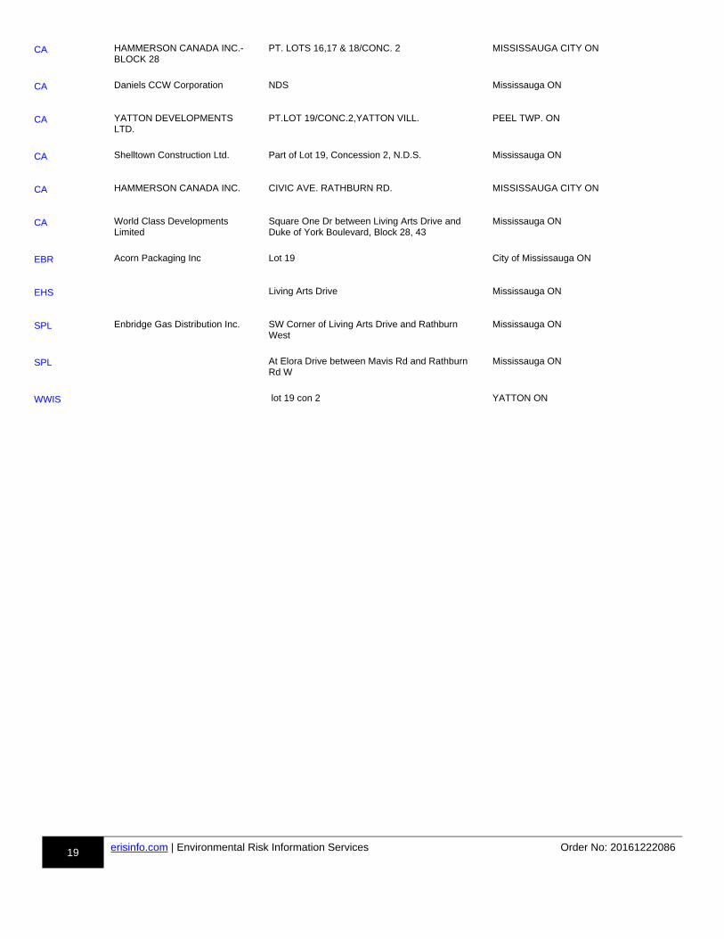
DB Company Name/Site Name Address City Postal
uu-CA-803759131-aa
Daniels CCW Corporation Part of Lot 18, Concession 2, N.D.S. Mississauga ON
uu-CA-803756237-aa
Daniels CCW Corporation Mississauga ON
uu-CA-803755481-aa
Daniels CCW Corporation Mississauga ON
uu-CA-19195-aa
MATTHEWS GROUP LIMITED CONFEDERATION PARKWAY MISSISSAUGA CITY ON
uu-CA-803765691-aa
The Corporation of the City of Mississauga
Confederation Parkway Mississauga ON
uu-CA-803744758-aa
The Regional Municipality of Peel Confederation Parkway (from Rathburn Road to Burnhamthorpe Road West)
Mississauga ON
uu-CA-803738746-aa
The Corporation of the City of Mississauga
Confederation Parkway Mississauga ON
uu-CA-51931-aa
MATTHEWS GROUP LIMITED CONFEDERATION PARKWAY MISSISSAUGA CITY ON
uu-CA-800405264-aa
Living Arts Drive Mississauga ON
uu-CA-800405185-aa
Living Arts Drive Mississauga ON
uu-CA-44865-aa
MISSISSAUGA CITY PRINCE OF WALES DR. MISSISSAUGA CITY ON
uu-CA-803758908-aa
The Sheridan College of Applied Arts and Technology
Prince of Wales Dr Mississauga ON
uu-CA-51079-aa
HAMMERSON CANADA INC. RATHBURN RD. MISSISSAUGA CITY ON
uu-CA-19324-aa
THE MATTHEWS GROUP LTD. RATHBURN RD. WOODS SUBD. PH.11 MISSISSAUGA CITY ON
uu-CA-51080-aa
HAMMERSON CANADA INC. RATHBURN RD. MISSISSAUGA CITY ON
uu-CA-18305-aa
HAMMERSON CANADA INC. RATHBURN RD. MISSISSAUGA CITY ON
uu-CA-33002-aa
THE MATTHEWS GROUP LIMITED
RATHBURN RD. WOOD SUBD. PH II MISSISSAUGA CITY ON
CA
CA
CA
CA
CA
CA
CA
CA
CA
CA
CA
CA
CA
CA
CA
CA
CA
Unplottable Summary
19 erisinfo.com | Environmental Risk Information Services Order No: 20161222086
uu-CA-37842-aa
HAMMERSON CANADA INC.-BLOCK 28
PT. LOTS 16,17 & 18/CONC. 2 MISSISSAUGA CITY ON
uu-CA-803765982-aa
Daniels CCW Corporation NDS Mississauga ON
uu-CA-46074-aa
YATTON DEVELOPMENTS LTD.
PT.LOT 19/CONC.2,YATTON VILL. PEEL TWP. ON
uu-CA-803742489-aa
Shelltown Construction Ltd. Part of Lot 19, Concession 2, N.D.S. Mississauga ON
uu-CA-42570-aa
HAMMERSON CANADA INC. CIVIC AVE. RATHBURN RD. MISSISSAUGA CITY ON
uu-CA-803751411-aa
World Class Developments Limited
Square One Dr between Living Arts Drive and Duke of York Boulevard, Block 28, 43
Mississauga ON
uu-EBR-800474024-aa
Acorn Packaging Inc Lot 19 City of Mississauga ON
uu-EHS-800535278-aa
Living Arts Drive Mississauga ON
uu-SPL-848859092-aa
Enbridge Gas Distribution Inc. SW Corner of Living Arts Drive and Rathburn West
Mississauga ON
uu-SPL-804334144-aa
At Elora Drive between Mavis Rd and Rathburn Rd W
Mississauga ON
uu-WWIS-802984082-aa
lot 19 con 2 YATTON ON
CA
CA
CA
CA
CA
CA
EBR
EHS
SPL
SPL
WWIS

20 erisinfo.com | Environmental Risk Information Services Order No: 20161222086
h-Unplottable Report
Site: Daniels CCW Corporation Part of Lot 18, Concession 2, N.D.S. Mississauga ON
Database:uu-CA-803759131-bb
Certificate #: 6905-6HARS5 Application Year: 2005Issue Date: 11/2/2005Approval Type: Municipal and Private Sewage WorksStatus: ApprovedApplication Type:Client Name::Client Address::Client City::Client Postal Code::Project Description::Contaminants::Emission Control::
Site: Daniels CCW Corporation Mississauga ON
Database:uu-CA-803756237-bb
Certificate #: 5944-5PYRRC Application Year: 2003Issue Date: 8/5/2003Approval Type: Municipal and Private Sewage WorksStatus: ApprovedApplication Type:Client Name::Client Address::Client City::Client Postal Code::Project Description::Contaminants::Emission Control::
Site: Daniels CCW Corporation Mississauga ON
Database:uu-CA-803755481-bb
Certificate #: 5677-776GZS Application Year: 2007Issue Date: 9/18/2007Approval Type: Municipal and Private Sewage WorksStatus: Revoked and/or ReplacedApplication Type:Client Name::Client Address::Client City::Client Postal Code::Project Description::Contaminants::Emission Control::
Site: MATTHEWS GROUP LIMITED CONFEDERATION PARKWAY MISSISSAUGA CITY ON
Database:uu-CA-19195-bb
Certificate #: 3-0171-86-
CA
CA
CA
CA
Unplottable Report

21 erisinfo.com | Environmental Risk Information Services Order No: 20161222086
Application Year: 86Issue Date: 5/2/1986Approval Type: Municipal sewageStatus: ApprovedApplication Type:Client Name::Client Address::Client City::Client Postal Code::Project Description::Contaminants::Emission Control::
Site: The Corporation of the City of Mississauga Confederation Parkway Mississauga ON
Database:uu-CA-803765691-bb
Certificate #: 9005-6FEK7P Application Year: 2005Issue Date: 8/22/2005Approval Type: Municipal and Private Sewage WorksStatus: ApprovedApplication Type:Client Name::Client Address::Client City::Client Postal Code::Project Description::Contaminants::Emission Control::
Site: The Regional Municipality of Peel Confederation Parkway (from Rathburn Road to Burnhamthorpe Road West) Mississauga ON
Database:uu-CA-803744758-bb
Certificate #: 2176-6EWPC2 Application Year: 2005Issue Date: 8/4/2005Approval Type: Municipal and Private Sewage WorksStatus: ApprovedApplication Type:Client Name::Client Address::Client City::Client Postal Code::Project Description::Contaminants::Emission Control::
Site: The Corporation of the City of Mississauga Confederation Parkway Mississauga ON
Database:uu-CA-803738746-bb
Certificate #: 0205-6ZAS2S Application Year: 2007Issue Date: 3/25/2007Approval Type: Municipal and Private Sewage WorksStatus: ApprovedApplication Type:Client Name::Client Address::Client City::Client Postal Code::Project Description::Contaminants::Emission Control::
CA
CA
CA

22 erisinfo.com | Environmental Risk Information Services Order No: 20161222086
Site: MATTHEWS GROUP LIMITED CONFEDERATION PARKWAY MISSISSAUGA CITY ON
Database:uu-CA-51931-bb
Certificate #: 7-0120-86-Application Year: 86Issue Date: 5/2/1986Approval Type: Municipal waterStatus: ApprovedApplication Type:Client Name::Client Address::Client City::Client Postal Code::Project Description::Contaminants::Emission Control::
Site: Living Arts Drive Mississauga ON
Database:uu-CA-800405264-bb
Certificate #: 3265-52SKNDApplication Year: 01Issue Date: 9/27/01Approval Type: Municipal & Private waterStatus: ApprovedApplication Type: New Certificate of ApprovalClient Name:: The Corporation of the Regional Municipality of PeelClient Address:: 10 Peel Centre Drive, Fourth FloorClient City:: BramptonClient Postal Code:: L6T 4B9Project Description:: Construction of Watermains on Living Arts DriveContaminants::Emission Control::
Site: Living Arts Drive Mississauga ON
Database:uu-CA-800405185-bb
Certificate #: 5979-52SKRVApplication Year: 01Issue Date: 9/27/01Approval Type: Municipal & Private sewageStatus: ApprovedApplication Type: New Certificate of ApprovalClient Name:: The Corporation of the Regional Municipality of PeelClient Address:: 10 Peel Centre Drive, Fourth FloorClient City:: BramptonClient Postal Code:: L6T 4B9Project Description:: Construction of Sanitary and Storm Sewers for Living Arts Drive ExtensionContaminants::Emission Control::
Site: MISSISSAUGA CITY PRINCE OF WALES DR. MISSISSAUGA CITY ON
Database:uu-CA-44865-bb
Certificate #: 7-0947-95-Application Year: 95Issue Date: 9/28/1995Approval Type: Municipal waterStatus: ApprovedApplication Type:Client Name::Client Address::
CA
CA
CA
CA

23 erisinfo.com | Environmental Risk Information Services Order No: 20161222086
Client City::Client Postal Code::Project Description::Contaminants::Emission Control::
Site: The Sheridan College of Applied Arts and Technology Prince of Wales Dr Mississauga ON
Database:uu-CA-803758908-bb
Certificate #: 6828-7ZVM65 Application Year: 2010Issue Date: 1/21/2010Approval Type: Municipal and Private Sewage WorksStatus: ApprovedApplication Type:Client Name::Client Address::Client City::Client Postal Code::Project Description::Contaminants::Emission Control::
Site: HAMMERSON CANADA INC. RATHBURN RD. MISSISSAUGA CITY ON
Database:uu-CA-51079-bb
Certificate #: 3-1264-86-Application Year: 86Issue Date: 8/29/1986Approval Type: Municipal sewageStatus: ApprovedApplication Type:Client Name::Client Address::Client City::Client Postal Code::Project Description::Contaminants::Emission Control::
Site: THE MATTHEWS GROUP LTD. RATHBURN RD. WOODS SUBD. PH.11 MISSISSAUGA CITY ON
Database:uu-CA-19324-bb
Certificate #: 3-0532-86-Application Year: 86Issue Date: 5/28/1986Approval Type: Municipal sewageStatus: ApprovedApplication Type:Client Name::Client Address::Client City::Client Postal Code::Project Description::Contaminants::Emission Control::
Site: HAMMERSON CANADA INC. RATHBURN RD. MISSISSAUGA CITY ON
Database:uu-CA-51080-bb
Certificate #: 7-1011-86-Application Year: 86
CA
CA
CA
CA
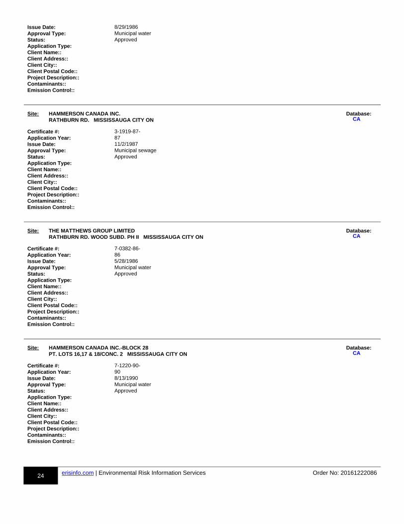
24 erisinfo.com | Environmental Risk Information Services Order No: 20161222086
Issue Date: 8/29/1986Approval Type: Municipal waterStatus: ApprovedApplication Type:Client Name::Client Address::Client City::Client Postal Code::Project Description::Contaminants::Emission Control::
Site: HAMMERSON CANADA INC. RATHBURN RD. MISSISSAUGA CITY ON
Database:uu-CA-18305-bb
Certificate #: 3-1919-87-Application Year: 87Issue Date: 11/2/1987Approval Type: Municipal sewageStatus: ApprovedApplication Type:Client Name::Client Address::Client City::Client Postal Code::Project Description::Contaminants::Emission Control::
Site: THE MATTHEWS GROUP LIMITED RATHBURN RD. WOOD SUBD. PH II MISSISSAUGA CITY ON
Database:uu-CA-33002-bb
Certificate #: 7-0382-86-Application Year: 86Issue Date: 5/28/1986Approval Type: Municipal waterStatus: ApprovedApplication Type:Client Name::Client Address::Client City::Client Postal Code::Project Description::Contaminants::Emission Control::
Site: HAMMERSON CANADA INC.-BLOCK 28 PT. LOTS 16,17 & 18/CONC. 2 MISSISSAUGA CITY ON
Database:uu-CA-37842-bb
Certificate #: 7-1220-90-Application Year: 90Issue Date: 8/13/1990Approval Type: Municipal waterStatus: ApprovedApplication Type:Client Name::Client Address::Client City::Client Postal Code::Project Description::Contaminants::Emission Control::
CA
CA
CA

25 erisinfo.com | Environmental Risk Information Services Order No: 20161222086
Site: Daniels CCW Corporation NDS Mississauga ON
Database:uu-CA-803765982-bb
Certificate #: 9105-79UHDW Application Year: 2007Issue Date: 12/14/2007Approval Type: Municipal and Private Sewage WorksStatus: ApprovedApplication Type:Client Name::Client Address::Client City::Client Postal Code::Project Description::Contaminants::Emission Control::
Site: YATTON DEVELOPMENTS LTD. PT.LOT 19/CONC.2,YATTON VILL. PEEL TWP. ON
Database:uu-CA-46074-bb
Certificate #: 3-1027-94-Application Year: 94Issue Date: 10/7/1994Approval Type: Municipal sewageStatus: ApprovedApplication Type:Client Name::Client Address::Client City::Client Postal Code::Project Description::Contaminants::Emission Control::
Site: Shelltown Construction Ltd. Part of Lot 19, Concession 2, N.D.S. Mississauga ON
Database:uu-CA-803742489-bb
Certificate #: 1440-63TLC9 Application Year: 2004Issue Date: 8/13/2004Approval Type: Municipal and Private Sewage WorksStatus: ApprovedApplication Type:Client Name::Client Address::Client City::Client Postal Code::Project Description::Contaminants::Emission Control::
Site: HAMMERSON CANADA INC. CIVIC AVE. RATHBURN RD. MISSISSAUGA CITY ON
Database:uu-CA-42570-bb
Certificate #: 7-1603-87-Application Year: 87Issue Date: 11/2/1987Approval Type: Municipal waterStatus: ApprovedApplication Type:Client Name::Client Address::Client City::
CA
CA
CA
CA

26 erisinfo.com | Environmental Risk Information Services Order No: 20161222086
Client Postal Code::Project Description::Contaminants::Emission Control::
Site: World Class Developments Limited Square One Dr between Living Arts Drive and Duke of York Boulevard, Block 28, 43 Mississauga ON
Database:uu-CA-803751411-bb
Certificate #: 4292-7DDRYG Application Year: 2008Issue Date: 4/8/2008Approval Type: Municipal and Private Sewage WorksStatus: ApprovedApplication Type:Client Name::Client Address::Client City::Client Postal Code::Project Description::Contaminants::Emission Control::
Site: Acorn Packaging Inc Lot 19 City of Mississauga ON
Database:uu-EBR-800474024-bb
Company Name:Year: 1999Notice Date:EBR Registry No.: IA9E0077Ministry Ref. No.:Notice Type: InstrumentInstrument Type: EPA s. 9 - Approval for discharge into the natural environment other than water (i.e. Air) Proposal Date: 1/20/99Location: City of MississaugaProponent Address: Acorn Packaging Inc.2333-2 Millrace Court,Mississauga, Ontario, L5N 1W2
Site:Living Arts Drive Mississauga ON
Database:uu-EHS-800535278-bb
Postal Code:City:Address2:Address1:Provstate:Order No.: 20020508007Addit. Info Ordered:: Fire Insur. Maps and/or Site Plans and/or Inspection ReportsReport Date: 5/17/02Report Type: Complete ReportSearch Radius (km): 0.35
Site: Enbridge Gas Distribution Inc. SW Corner of Living Arts Drive and Rathburn West Mississauga ON
Database:uu-SPL-848859092-bb
Ref NO: 3262-9YPV92Contaminant Code: 35Contaminant Name: NATURAL GAS (METHANE)Contaminant Quantity: 0 other - see incident descriptionIncident Cause::Incident Dt: 7/23/2015Incident Reason:: Operator/Human ErrorIncident Summary:: TSSA FSB: 4 inch plastic main dmg; made safeMOE Reported Dt: 7/23/2015
CA
EBR
EHS
SPL

27 erisinfo.com | Environmental Risk Information Services Order No: 20161222086
Environmental Impact::Nature of Impact::Receiving Medium::SAC Action Class: TSSA - Fuel Safety Branch - Hydrocarbon Fuel Release/SpillSector Source Type: Unknown / N/ASite Municipality: Mississauga
Site:At Elora Drive between Mavis Rd and Rathburn Rd W Mississauga ON
Database:uu-SPL-804334144-bb
Ref NO: 6026-8RHVUFContaminant Code: 27Contaminant Name: GLUEContaminant Quantity:Incident Cause:: Other Transport AccidentIncident Dt: 15-FEB-12Incident Reason:: SpillIncident Summary:: Paper Line Canada: Polymer to rdway, cont, clnd.MOE Reported Dt: 15-FEB-12Environmental Impact:: Not AnticipatedNature of Impact:: Other Impact(s)Receiving Medium:: Sewage - Municipal/Private and CommercialSAC Action Class: Land SpillsSector Source Type: Transport TruckSite Municipality: Mississauga
Site: lot 19 con 2 YATTON ON
Database:uu-WWIS-802984082-bb
Well ID: 6714987 Lot: 019Construction Date:: Concession: 02Primary Water Use:: Domestic Concession Name: CONSec. Water Use:: Easting NAD83::Final Well Status:: Water Supply Northing NAD83::Specific Capacity:: Zone::Municipality: PEEL TOWNSHIP UTM Reliability::County: WELLINGTON
Bore Hole Information-- --Bore Hole ID: 11179624DP2BR:Code OB: oCode OB Description: OverburdenOpen Hole:Date Completed: 01-JUL-04Remarks:Zone:East 83:North 83:UTMRC: 9UTMRC Description: unknown UTMLocation Method: naOrg CS:Elevation:Elevrc:Elevrc Description:Location Source Date:Source Revision Comment:Improvement Location Source:Improvement Location Method:Supplier Comment:Spatial Status:-- --Overburden and Bedrock Materials Interval
SPL
WWIS

28 erisinfo.com | Environmental Risk Information Services Order No: 20161222086
-- --Formation ID: 932990303Layer: 1General Color: BROWNMost Common Material: CLAYOther Materials:Other Materials:Formation Top Depth: 0Formation End Depth: 4Formation End Depth UOM: ft-- --Formation ID: 932990304Layer: 2General Color: BROWNMost Common Material: CLAYOther Materials:Other Materials:Formation Top Depth: 4Formation End Depth: 45Formation End Depth UOM: ft-- --Formation ID: 932990305Layer: 3General Color: GREYMost Common Material: CLAYOther Materials: HARDPANOther Materials:Formation Top Depth: 45Formation End Depth: 76Formation End Depth UOM: ft-- --Formation ID: 932990306Layer: 4General Color: BROWNMost Common Material: MEDIUM GRAVELOther Materials:Other Materials:Formation Top Depth: 76Formation End Depth: 89Formation End Depth UOM: ft-- --Annular Space/Abandonment Sealing Record-- --Plug ID: 933262661Layer: 1Plug From: 0Plug To: 80Plug Depth UOM: ft-- --Method of Construction & Well Use-- --Method Construction ID: 966714987Method Construction Code: 2Method Construction: Rotary (Convent.)Other Method Construction:-- --Pipe Information-- --Pipe ID: 11188143Casing Number: 1Comment:Alt Name:-- --Construction Record - Casing-- --Casing ID: 930852815Layer: 1

29 erisinfo.com | Environmental Risk Information Services Order No: 20161222086
Open Hole or Material: STEELDepth From: 2Depth To: 85Casing Diameter: 6.25Casing Diameter UOM: inchCasing Depth UOM: ft-- ---- --Construction Record - Screen-- --Screen ID: 933410995Layer: 1Slot: 30Screen Top Depth: 85Screen End Depth: 89Screen Material:Screen Depth UOM: ftScreen Diameter UOM: inchScreen Diameter: 6.625-- --Well Yield Testing-- --Pump Test ID: 11194547Pump Set At: 70Static Level: 40Final Level After Pumping: 70Recommended Pump Depth: 70Pumping Rate: 50Flowing Rate:Recommended Pump Rate: 25Levels UOM: ftRate UOM: GPMWater State After Test Code: 1Water State After Test: CLEARPumping Test Method: 2Pumping Duration HR: 2Pumping Duration MIN: 30Flowing:-- --Draw Down & Recovery-- --Pump Test Detail ID: 11198819Pump Test ID: 11194547Test Type: Draw DownTest Duration: 1Test Level: 70Test Level UOM: ft-- --Pump Test Detail ID: 11198820Pump Test ID: 11194547Test Type: RecoveryTest Duration: 1Test Level: 42Test Level UOM: ft-- --Pump Test Detail ID: 11198821Pump Test ID: 11194547Test Type: RecoveryTest Duration: 2Test Level: 41Test Level UOM: ft-- --Pump Test Detail ID: 11198822Pump Test ID: 11194547Test Type: RecoveryTest Duration: 3Test Level: 40Test Level UOM: ft-- --

30 erisinfo.com | Environmental Risk Information Services Order No: 20161222086
Pump Test Detail ID: 11198823Pump Test ID: 11194547Test Type: Draw DownTest Duration: 60Test Level: 70Test Level UOM: ft-- ---- --Water Details-- --Water ID: 934057137Layer: 1Kind Code: 1Kind: FRESHWater Found Depth: 85Water Found Depth UOM: ft-- --Hole Diameter-- --Hole ID: 11313986Diameter: 8.75Depth From: 0Depth To: 89Hole Depth UOM: ftHole Diameter UOM: inch-- ---- --
31 erisinfo.com | Environmental Risk Information Services Order No: 20161222086
h-Appendix: Database Descriptions
Environmental Risk Information Services (ERIS) can search the following databases. The extent of historical information varies with each database and current information is determined by what is publicly available to ERIS at the time of update. Note: Databases denoted with " * " indicates that the database will no longer be updated. See the individual database description for more information.
Abandoned Aggregate Inventory: Provincialrr-AAGR-bb
The MAAP Program maintains a database of abandoned pits and quarries. Please note that the database is only referenced by lot and concession and city/town location. The database provides information regarding the location, type, size, land use, status and general comments.*Government Publication Date: Sept 2002*
Aggregate Inventory: Provincialrr-AGR-bb
The Ontario Ministry of Natural Resources maintains a database of all active pits and quarries. The database provides information regarding the registered owner/operator, location name, operation type, approval type, and maximum annual tonnage.Government Publication Date: Up to Sep 2016
Abandoned Mine Information System: Provincialrr-AMIS-bb
The Abandoned Mines Information System contains data on known abandoned and inactive mines located on both Crown and privately held lands. Theinformation was provided by the Ministry of Northern Development and Mines (MNDM), with the following disclaimer: "the database provided has been compiled from various sources, and the Ministry of Northern Development and Mines makes no representation and takes no responsibility that such information is accurate, current or complete". Reported information includes official mine name, status, background information, mine start/end date, primary commodity, mine features, hazards and remediation.Government Publication Date: Oct 31, 2014
Anderson's Waste Disposal Sites: Privaterr-ANDR-bb
The information provided in this database was collected by examining various historical documents which aimed to characterize the likely position of former waste disposal sites from 1860 to present. The research initiative behind the creation of this database was to identify those sites that are missingfrom the Ontario MOE Waste Disposal Site Inventory, as well as to provide revisions and corrections to the positions and descriptions of sites currently listed in the MOE inventory. In addition to historic waste disposal facilities, the database also identifies certain auto wreckers and scrap yards that have been extrapolated from documentary sources. Please note that the data is not warranted to be complete, exhaustive or authoritative. The information was collected for research purposes only.Government Publication Date: 1860s-Present
Automobile Wrecking & Supplies: Privaterr-AUWR-bb
This database provides an inventory of known locations that are involved in the scrap metal, automobile wrecking/recycling, and automobile parts & supplies industry. Information is provided on the company name, location and business type.Government Publication Date: Oct 31, 2016
Borehole: Provincialrr-BORE-bb
A borehole is the generalized term for any narrow shaft drilled in the ground, either vertically or horizontally. The information here includes geotechnical investigations or environmental site assessments, mineral exploration, or as a pilot hole for installing piers or underground utilities. Information is from many sources such as the Ministry of Transportation (MTO) boreholes from engineering reports and projects from the 1950 to 1990's in Southern Ontario. Boreholes from the Ontario Geological Survey (OGS) including The Urban Geology Analysis Information System (UGAIS) and the York Peel Durham Toronto (YPDT) database of the Conservation Authority Moraine Coalition. This database will include fields such as location, stratigraphy, depth, elevation, year drilled, etc. For all water well data or oil and gas well data for Ontario please refer to WWIS and OOGW.Government Publication Date: 1875-Jul 2014
Certificates of Approval: Provincialrr-CA-bb
This database contains the following types of approvals: Air & Noise, Industrial Sewage, Municipal & Private Sewage, Waste Management Systems andRenewable Energy Approvals. The MOE in Ontario states that any facility that releases emissions to the atmosphere, discharges contaminants to ground or surface water, provides potable water supplies, or stores, transports or disposes of waste, must have a Certificate of Approval before it can operate lawfully. Fields include approval number, business name, address, approval date, approval type and status. This database will no longer be updated, as CofA's have been replaced by either Environmental Activity and Sector Registry (EASR) or Environmental Compliance Approval (ECA). Please refer to those individual databases for any information after Oct.31, 2011.Government Publication Date: 1985-Oct 30, 2011*
AAGR
AGR
AMIS
ANDR
AUWR
BORE
CA
Appendix: Database Descriptions

32 erisinfo.com | Environmental Risk Information Services Order No: 20161222086
Commercial Fuel Oil Tanks: Provincialrr-CFOT-bb
Since May 2002, Ontario developed a new act where it became mandatory for fuel oil tanks to be registered with Technical Standards & Safety Authority(TSSA). This data would include all commercial underground fuel oil tanks in Ontario with fields such as location, registration number, tank material, age of tank and tank size.Government Publication Date: Oct 31, 2016
Chemical Register: Privaterr-CHEM-bb
This database includes information from both a one time study conducted in 1992 and private source and is a listing of facilities that manufacture or distribute chemicals. The production of these chemical substances may involve one or more chemical reactions and/or chemical separation processes (i.e. fractionation, solvent extraction, crystallization, etc.).Government Publication Date: Oct 31, 2016
Compressed Natural Gas Stations: Privaterr-CNG-bb
Canada has a network of public access compressed natural gas (CNG) refuelling stations. These stations dispense natural gas in compressed form at 3,000 pounds per square inch (psi), the pressure which is allowed within the current Canadian codes and standards. The majority of natural gas refuelling is located at existing retail gasoline that have a separate refuelling island for natural gas. This list of stations is made available by the Canadian Natural Gas Vehicle Alliance.Government Publication Date: Dec 31, 2012
Inventory of Coal Gasification Plants and Coal Tar Sites: Provincialrr-COAL-bb
This inventory includes both the "Inventory of Coal Gasification Plant Waste Sites in Ontario-April 1987" and the Inventory of Industrial Sites Producing or Using Coal Tar and Related Tars in Ontario-November 1988) collected by the MOE. It identifies industrial sites that produced and continue to produceor use coal tar and other related tars. Detailed information is available and includes: facility type, size, land use, information on adjoining properties, soil condition, site operators/occupants, site description, potential environmental impacts and historic maps available. This was a one-time inventory.*Government Publication Date: Apr 1987 and Nov 1988*
Compliance and Convictions: Provincialrr-CONV-bb
This database summarizes the fines and convictions handed down by the Ontario courts beginning in 1989. Companies and individuals named here have been found guilty of environmental offenses in Ontario courts of law.Government Publication Date: Nov 30, 2016
Certificates of Property Use: Provincialrr-CPU-bb
This is a subset taken from Ontario's Environmental Registry (EBR) database. It will include all CPU's on the registry such as (EPA s. 168.6) - Certificate of Property Use.Government Publication Date: Nov 30, 2016
Drill Hole Database: Provincialrr-DRL-bb
The Ontario Drill Hole Database contains information on more than 113,000 percussion, overburden, sonic and diamond drill holes from assessment files on record with the department of Mines and Minerals. Please note that limited data is available for southern Ontario, as it was the last area to be completed. The database was created when surveys submitted to the Ministry were converted in the Assessment File Research Image Database (AFRI) project. However, the degree of accuracy (coordinates) as to the exact location of drill holes is dependent upon the source document submitted to the MNDM. Levels of accuracy used to locate holes are: centering on the mining claim; a sketch of the mining claim; a 1:50,000 map; a detailed company map; or from submitted a "Report of Work".Government Publication Date: Aug 31, 2015
Environmental Activity and Sector Registry: Provincialrr-EASR-bb
On October 31, 2011, a smarter, faster environmental approvals system came into effect in Ontario. The EASR allows businesses to register certain activities with the ministry, rather than apply for an approval. The registry is available for common systems and processes, to which preset rules of operation can be applied. The EASR is currently available for: heating systems, standby power systems and automotive refinishing. Businesses whoseactivities aren't subject to the EASR may apply for an ECA (Environmental Compliance Approval), Please see our ECA database.Government Publication Date: Nov 30, 2016
Environmental Registry: Provincialrr-EBR-bb
The Environmental Registry lists proposals, decisions and exceptions regarding policies, Acts, instruments, or regulations that could significantly affect the environment. Through the Registry, thirteen provincial ministries notify the public of upcoming proposals and invite their comments. For example, if alocal business is requesting a permit, license, or certificate of approval to release substances into the air or water; these are notified on the registry. Dataincludes: Approval for discharge into the natural environment other than water (i.e. Air) - EPA s. 9, Approval for sewage works - OWRA s. 53(1), and EPA s. 27 - Approval for a waste disposal site. For information regarding Permit to Take Water (PTTW), Certificate of Property Use (CPU) and (ORD) Orders please refer to those individual databases.Government Publication Date: Nov 30, 2016
CFOT
CHEM
CNG
COAL
CONV
CPU
DRL
EASR
EBR
33 erisinfo.com | Environmental Risk Information Services Order No: 20161222086
Environmental Compliance Approval: Provincialrr-ECA-bb
On October 31, 2011, a smarter, faster environmental approvals system came into effect in Ontario. In the past, a business had to apply for multiple approvals (known as certificates of approval) for individual processes and pieces of equipment. Today, a business either registers itself, or applies for a single approval, depending on the types of activities it conducts. Businesses whose activities aren't subject to the EASR may apply for an ECA. A single ECA addresses all of a business's emissions, discharges and wastes. Separate approvals for air, noise and waste are no longer required. This databasewill also include Renewable Energy Approvals. For certificates of approval prior to Nov 1st, 2011, please refer to the CA database. For all Waste Disposal Sites please refer to the WDS database.Government Publication Date: Nov 30, 2016
Environmental Effects Monitoring: Federalrr-EEM-bb
The Environmental Effects Monitoring program assesses the effects of effluent from industrial or other sources on fish, fish habitat and human usage of fisheries resources. Since 1992, pulp and paper mills have been required to conduct EEM studies under the Pulp and Paper Effluent Regulations. This database provides information on the mill name, geographical location and sub-lethal toxicity data.Government Publication Date: 1992-2007*
ERIS Historical Searches: Privaterr-EHS-bb
ERIS has compiled a database of all environmental risk reports completed since March 1999. Available fields for this database include: site location, date of report, type of report, and search radius. As per all other databases, the ERIS database can be referenced on both the map and "Statistical Profile" page.Government Publication Date: 1999-Aug 2016
Environmental Issues Inventory System: Federalrr-EIIS-bb
The Environmental Issues Inventory System was developed through the implementation of the Environmental Issues and Remediation Plan. This plan was established to determine the location and severity of contaminated sites on inhabited First Nation reserves, and where necessary, to remediate those that posed a risk to health and safety; and to prevent future environmental problems. The EIIS provides information on the reserve under investigation, inventory number, name of site, environmental issue, site action (Remediation, Site Assessment), and date investigation completed.Government Publication Date: 1992-2001*
Emergency Management Historical Event: Provincialrr-EMHE-bb
The Emergency Management Historical Event data class will store the locations of historical occurrences of emergency events. Events captured will include those assigned to the Ministry of Natural Resources by Order-In-Council (OIC) under the Emergency Management and Civil Protection Act as well as events where MNR provided requested emergency response assistance. Many of these events will have involved community evacuations, significant structural loss, and/or involvement of MNR emergency response staff. These events fall into one of ten (10) type categories: Dam Failure; Drought / Low Water; Erosion; Flood; Forest Fire; Soil and Bedrock Instability; Petroleum Resource Center Event, EMO Requested Assistance, Continuity of Operations Event, Other Requested Assistance.Government Publication Date: May 31, 2014
List of TSSA Expired Facilities: Provincialrr-EXP-bb
This is a list of all expired facilities that fall under the TSSA (TSSA Act & Safety Regulations), including the six regulations that exist under the Fuels Safety Division. It will include facilities such as private fuel outlets, bulk plants, fuel oil tanks, gasoline stations, marinas, propane filling stations, liquid fuel tanks, piping systems, etc. These tanks have been removed and automatically fall under the expired facilities inventory held by TSSA.Government Publication Date: Oct 31, 2016
Federal Convictions: Federalrr-FCON-bb
Environment Canada maintains a database referred to as the "Environmental Registry" that details prosecutions under the Canadian Environmental Protection Act (CEPA) and the Fisheries Act (FA). Information is provided on the company name, location, charge date, offence and penalty.Government Publication Date: 1988-Jun 2007*
Contaminated Sites on Federal Land: Federalrr-FCS-bb
The Federal Contaminated Sites Inventory includes information on known federal contaminated sites under the custodianship of departments, agencies and consolidated Crown corporations as well as those that are being or have been investigated to determine whether they have contamination arising from past use that could pose a risk to human health or the environment. The inventory also includes non-federal contaminated sites for which the Government of Canada has accepted some or all financial responsibility. It does not include sites where contamination has been caused by, and which are under the control of, enterprise Crown corporations, private individuals, firms or other levels of government.Government Publication Date: June 2000-Oct 2015
Fisheries & Oceans Fuel Tanks: Federalrr-FOFT-bb
Fisheries & Oceans Canada maintains an inventory of aboveground & underground fuel storage tanks located on Fisheries & Oceans property or controlled by DFO. Our inventory provides information on the site name, location, tank owner, tank operator, facility type, storage tank location, tank contents & capacity, and date of tank installation.Government Publication Date: 1964-Sept 2003
ECA
EEM
EHS
EIIS
EMHE
EXP
FCON
FCS
FOFT
34 erisinfo.com | Environmental Risk Information Services Order No: 20161222086
Fuel Storage Tank: Provincialrr-FST-bb
The Technical Standards & Safety Authority (TSSA), under the Technical Standards & Safety Act of 2000 maintains a database of registered private andretail fuel storage tanks in Ontario with fields such as location, tank status, license date, tank type, tank capacity, fuel type, installation year and facility type.Government Publication Date: Oct 31, 2016
Fuel Storage Tank - Historic: Provincialrr-FSTH-bb
The Fuels Safety Branch of the Ontario Ministry of Consumer and Commercial Relations maintained a database of all registered private fuel storage tanks. Public records of private fuel storage tanks are only available since the registration became effective in September 1989. This information is now collected by the Technical Standards and Safety Authority.Government Publication Date: Pre-Jan 2010*
Ontario Regulation 347 Waste Generators Summary: Provincialrr-GEN-bb
Regulation 347 of the Ontario EPA defines a waste generation site as any site, equipment and/or operation involved in the production, collection, handling and/or storage of regulated wastes. A generator of regulated waste is required to register the waste generation site and each waste produced, collected, handled, or stored at the site. This database contains the registration number, company name and address of registered generators includingthe types of hazardous wastes generated. It includes data on waste generating facilities such as: drycleaners, waste treatment and disposal facilities, machine shops, electric power distribution etc. This information is a summary of all years from 1986 including the most currently available data. Some records may contain, within the company name, the phrase "See & Use..." followed by a series of letters and numbers. This occurs when one company is amalgamated with or taken over by another registered company. The number listed as "See & Use", refers to the new ownership and the other identification number refers to the original ownership. This phrase serves as a link between the 2 companies until operations have been fully transferred.Government Publication Date: 1986-Sep 2016
Greenhouse Gas Emissions from Large Facilities: Federalrr-GHG-bb
List of greenhouse gas emissions from large facilities made available by Environment Canada. Greenhouse gas emissions in kilotonnes of carbon dioxide equivalents (kt CO2 eq).Government Publication Date: 2013 - Dec 2014
TSSA Historic Incidents: Provincialrr-HINC-bb
This database will cover all incidences recorded by TSSA with their older system, before they moved to their new management system. TSSA's Fuels Safety Program administers the Technical Standards & Safety Act 2000, providing fuel-related safety services associated with the safe transportation, storage, handling and use of fuels such as gasoline, diesel, propane, natural gas and hydrogen. Under this Act, TSSA regulates fuel suppliers, storage facilities, transport trucks, pipelines, contractors and equipment or appliances that use fuels. The TSSA works to protect the public, the environment and property from fuel-related hazards such as spills, fires and explosions. This database will include spills and leaks from pipelines, diesel, fuel oil, gasoline,natural gas, propane and hydrogen recorded by the TSSA.Government Publication Date: 2006-June 2009*
Indian & Northern Affairs Fuel Tanks: Federalrr-IAFT-bb
The Department of Indian & Northern Affairs Canada (INAC) maintains an inventory of aboveground & underground fuel storage tanks located on both federal and crown land. Our inventory provides information on the reserve name, location, facility type, site/facility name, tank type, material & ID number, tank contents & capacity, and date of tank installation.Government Publication Date: 1950-Aug 2003*
TSSA Incidents: Provincialrr-INC-bb
TSSA's Fuels Safety Program administers the Technical Standards & Safety Act 2000, providing fuel-related safety services associated with the safe transportation, storage, handling and use of fuels such as gasoline, diesel, propane, natural gas and hydrogen. Under this Act, TSSA regulates fuel suppliers, storage facilities, transport trucks, pipelines, contractors and equipment or appliances that use fuels. Includes incidents from fuel-related hazards such as spills, fires and explosions. This database will include spills and leaks from diesel, fuel oil, gasoline, natural gas, propane and hydrogenrecorded by the TSSA.Government Publication Date: Oct 31, 2016
Landfill Inventory Management Ontario: Provincialrr-LIMO-bb
The Landfill Inventory Management Ontario (LIMO) database is updated every year, as the ministry compiles new and updated information. The inventory will include small and large landfills. Additionally, each year the ministry will request operators of the larger landfills complete a landfill data collection form that will be used to update LIMO and will include the following information from the previous operating year. This will include additional information such as estimated amount of total waste received, landfill capacity, estimated total remaining landfill capacity, fill rates, engineering designs, reporting and monitoring details, size of location, service area, approved waste types, leachate of site treatment, contaminant attenuation zone and more. The small landfills will include information such as site owner, site location and certificate of approval # and status.Government Publication Date: Dec 31, 2013
FST
FSTH
GEN
GHG
HINC
IAFT
INC
LIMO

35 erisinfo.com | Environmental Risk Information Services Order No: 20161222086
Canadian Mine Locations: Privaterr-MINE-bb
This information is collected from the Canadian & American Mines Handbook. The Mines database is a national database that provides over 290 listings on mines (listed as public companies) dealing primarily with precious metals and hard rocks. Listed are mines that are currently in operation, closed, suspended, or are still being developed (advanced projects). Their locations are provided as geographic coordinates (x, y and/or longitude, latitude). As of 2002, data pertaining to Canadian smelters and refineries has been appended to this database.Government Publication Date: 1998-2009*
Mineral Occurrences: Provincialrr-MNR-bb
In the early 70's, the Ministry of Northern Development and Mines created an inventory of approximately 19,000 mineral occurrences in Ontario, in regard to metallic and industrial minerals, as well as some information on building stones and aggregate deposits. Please note that the "Horizontal Positional Accuracy" is approximately +/- 200 m. Many reference elements for each record were derived from field sketches using pace or chain/tape measurements against claim posts or topographic features in the area. The primary limiting factor for the level of positional accuracy is the scale of the source material. The testing of horizontal accuracy of the source materials was accomplished by comparing the plan metric (X and Y) coordinates of thatpoint with the coordinates of the same point as defined from a source of higher accuracy.Government Publication Date: 1846-Feb 2016
National Analysis of Trends in Emergencies System (NATES): Federalrr-NATE-bb
In 1974 Environment Canada established the National Analysis of Trends in Emergencies System (NATES) database, for the voluntary reporting of significant spill incidents. The data was to be used to assist in directing the work of the emergencies program. NATES ran from 1974 to 1994. Extensive information is available within this database including company names, place where the spill occurred, date of spill, cause, reason and sourceof spill, damage incurred, and amount, concentration, and volume of materials released.Government Publication Date: 1974-1994*
Non-Compliance Reports: Provincialrr-NCPL-bb
The Ministry of the Environment provides information about non-compliant discharges of contaminants to air and water that exceed legal allowable limits, from regulated industrial and municipal facilities. A reported non-compliance failure may be in regard to a Control Order, Certificate of Approval, Sectoral Regulation or specific regulation/act.Government Publication Date: Dec 31, 2014
National Defense & Canadian Forces Fuel Tanks: Federalrr-NDFT-bb
The Department of National Defense and the Canadian Forces maintains an inventory of all aboveground & underground fuel storage tanks located on DND lands. Our inventory provides information on the base name, location, tank type & capacity, tank contents, tank class, date of tank installation, date tank last used, and status of tank as of May 2001. This database will no longer be updated due to the new National Security protocols which have prohibited any release of this database.Government Publication Date: Up to May 2001*
National Defense & Canadian Forces Spills: Federalrr-NDSP-bb
The Department of National Defense and the Canadian Forces maintains an inventory of spills to land and water. All spill sites have been classified under the "Transportation of Dangerous Goods Act - 1992". Our inventory provides information on the facility name, location, spill ID #, spill date, type of spill, as well as the quantity of substance spilled & recovered.Government Publication Date: Mar 1999-Aug 2010
National Defence & Canadian Forces Waste Disposal Sites: Federalrr-NDWD-bb
The Department of National Defence and the Canadian Forces maintains an inventory of waste disposal sites located on DND lands. Where available, our inventory provides information on the base name, location, type of waste received, area of site, depth of site, year site opened/closed and status.Government Publication Date: 2001-Apr 2007*
National Energy Board Wells: Federalrr-NEBW-bb
The NEBW database contains information on onshore & offshore oil and gas wells that are outside provincial jurisdiction(s) and are thereby regulated bythe National Energy Board. Data is provided regarding the operator, well name, well ID No./UWI, status, classification, well depth, spud and release date.Government Publication Date: 1920-Feb 2003*
MINE
MNR
NATE
NCPL
NDFT
NDSP
NDWD
NEBW

36 erisinfo.com | Environmental Risk Information Services Order No: 20161222086
National Environmental Emergencies System (NEES): Federalrr-NEES-bb
In 2000, the Emergencies program implemented NEES, a reporting system for spills of hazardous substances. For the most part, this system only captured data from the Atlantic Provinces, some from Quebec and Ontario and a portion from British Columbia. Data for Alberta, Saskatchewan, Manitoba and the Territories was not captured. However, NEES is also a repository for previous Environment Canada spill datasets. NEES is composed of the historic datasets ' or Trends ' which dates from approximately 1974 to present. NEES Trends is a compilation of historic databases, which were merged and includes data from NATES (National Analysis of Trends in Emergencies System), ARTS (Atlantic Regional Trends System), and NEES. In 2001, the Emergencies Program determined that variations in reporting regimes and requirements between federal and provincial agencies made national spill reporting and trend analysis difficult to achieve. As a consequence, the department has focused efforts on capturing data on spills of substances which fall under its legislative authority only (CEPA and FA). As such, the NEES database will be decommissioned in December 2004.Government Publication Date: 1974-2003*
National PCB Inventory: Federalrr-NPCB-bb
Environment Canada's National PCB inventory includes information on in-use PCB containing equipment in Canada including federal, provincial and private facilities. Federal out-of-service PCB containing equipment and PCB waste owned by the federal government or by federally regulated industriessuch as airlines, railway companies, broadcasting companies, telephone and telecommunications companies, pipeline companies, etc. are also listed. Although it is not Environment Canada's mandate to collect data on non-federal PCB waste, the National PCB inventory includes some information on provincial and private PCB waste and storage sites. Some addresses provided may be Head Office addresses and are not necessarily the location of where the waste is being used or stored.Government Publication Date: 1988-2008*
National Pollutant Release Inventory: Federalrr-NPRI-bb
Environment Canada has defined the National Pollutant Release Inventory ("NPRI") as a federal government initiative designed to collect comprehensive national data regarding releases to air, water, or land, and waste transfers for recycling for more than 300 listed substances.Government Publication Date: Dec 31, 2014
Oil and Gas Wells: Privaterr-OGW-bb
The Nickle's Energy Group (publisher of the Daily Oil Bulletin) collects information on drilling activity including operator and well statistics. The well information database includes name, location, class, status and depth. The main Nickle's database is updated on a daily basis, however, this database is updated on a monthly basis. More information is available at www.nickles.com.Government Publication Date: 1988-Jun 2016
Ontario Oil and Gas Wells: Provincialrr-OOGW-bb
In 1998, the MNR handed over to the Ontario Oil, Gas and Salt Resources Corporation, the responsibility of maintaining a database of oil and gas wells drilled in Ontario. The OGSR Library has over 20,000+ wells in their database. Information available for all wells in the ERIS database include well owner/operator, location, permit issue date, and well cap date, license No., status, depth and the primary target (rock unit) of the well being drilled. All geology/stratigraphy table information, plus all water table information is also provide for each well record.Government Publication Date: Oct 31, 2016
Inventory of PCB Storage Sites: Provincialrr-OPCB-bb
The Ontario Ministry of Environment, Waste Management Branch, maintains an inventory of PCB storage sites within the province. Ontario Regulation 11/82 (Waste Management - PCB) and Regulation 347 (Generator Waste Management) under the Ontario EPA requires the registration of inactive PCBstorage equipment and/or disposal sites of PCB waste with the Ontario Ministry of Environment. This database contains information on: 1) waste quantities; 2) major and minor sites storing liquid or solid waste; and 3) a waste storage inventory.Government Publication Date: 1987-Oct 2004; 2012-Dec 2013
Orders: Provincialrr-ORD-bb
This is a subset taken from Ontario's Environmental Registry (EBR) database. It will include all Orders on the registry such as (EPA s. 17) - Order for remedial work, (EPA s. 18) - Order for preventative measures, (EPA s. 43) - Order for removal of waste and restoration of site, (EPA s. 44) - Order for conformity with Act for waste disposal sites, (EPA s. 136) - Order for performance of environmental measures.Government Publication Date: Nov 30, 2016
Canadian Pulp and Paper: Privaterr-PAP-bb
This information is part of the Pulp and Paper Canada Directory. The Directory provides a comprehensive listing of the locations of pulp and paper mills and the products that they produce.Government Publication Date: 1999, 2002, 2004, 2005, 2009
Parks Canada Fuel Storage Tanks: Federalrr-PCFT-bb
Canadian Heritage maintains an inventory of known fuel storage tanks operated by Parks Canada, in both National Parks and at National Historic Sites.The database details information on site name, location, tank install/removal date, capacity, fuel type, facility type, tank design and owner/operator.Government Publication Date: 1920-Jan 2005*
NEES
NPCB
NPRI
OGW
OOGW
OPCB
ORD
PAP
PCFT

37 erisinfo.com | Environmental Risk Information Services Order No: 20161222086
Pesticide Register: Provincialrr-PES-bb
The Ontario Ministry of the Environment and Climate Change maintains a database of licensed operators and vendors of registered pesticides.
Government Publication Date: Oct 31, 2016
TSSA Pipeline Incidents: Provincialrr-PINC-bb
TSSA's Fuels Safety Program administers the Technical Standards & Safety Act 2000, providing fuel-related safety services associated with the safe transportation, storage, handling and use of fuels such as gasoline, diesel, propane, natural gas and hydrogen. Under this Act, TSSA regulates fuel suppliers, storage facilities, transport trucks, pipelines, contractors and equipment or appliances that use fuels. This database will include spills, strike and leaks from recorded by the TSSA.Government Publication Date: Oct 31, 2016
Private and Retail Fuel Storage Tanks: Provincialrr-PRT-bb
The Fuels Safety Branch of the Ontario Ministry of Consumer and Commercial Relations maintained a database of all registered private fuel storage tanks and licensed retail fuel outlets. This database includes an inventory of locations that have gasoline, oil, waste oil, natural gas and/or propane storage tanks on their property. The MCCR no longer collects this information. This information is now collected by the Technical Standards and Safety Authority (TSSA).Government Publication Date: 1989-1996*
Permit to Take Water: Provincialrr-PTTW-bb
This is a subset taken from Ontario's Environmental Registry (EBR) database. It will include all PTTW's on the registry such as OWRA s. 34 - Permit to take water.Government Publication Date: Nov 30, 2016
Ontario Regulation 347 Waste Receivers Summary: Provincialrr-REC-bb
Part V of the Ontario Environmental Protection Act ("EPA") regulates the disposal of regulated waste through an operating waste management system or a waste disposal site operated or used pursuant to the terms and conditions of a Certificate of Approval or a Provisional Certificate of Approval. Regulation 347 of the Ontario EPA defines a waste receiving site as any site or facility to which waste is transferred by a waste carrier. A receiver of regulated waste is required to register the waste receiving facility. This database represents registered receivers of regulated wastes, identified by registration number, company name and address, and includes receivers of waste such as: landfills, incinerators, transfer stations, PCB storage sites, sludge farms and water pollution control plants. This information is a summary of all years from 1986 including the most currently available data.Government Publication Date: 1986-2013
Record of Site Condition: Provincialrr-RSC-bb
The Record of Site Condition (RSC) is part of the Ministry of the Environment's Brownfields Environmental Site Registry. Protection from environmental cleanup orders for property owners is contingent upon documentation known as a record of site condition (RSC) being filed in the Environmental Site Registry. In order to file an RSC, the property must have been properly assessed and shown to meet the soil, sediment and groundwater standards appropriate for the use (such as residential) proposed to take place on the property. The Record of Site Condition Regulation (O. Reg. 153/04) details requirements related to site assessment and clean up. RSCs filed after July 1, 2011 will also be included as part of the new (O.Reg. 511/09).Government Publication Date: Oct 31, 2016
Retail Fuel Storage Tanks: Privaterr-RST-bb
This database includes an inventory of retail fuel outlet locations (including marinas) that have on their property gasoline, oil, waste oil, natural gas and / or propane storage tanks.Government Publication Date: Oct 31, 2016
Scott's Manufacturing Directory: Privaterr-SCT-bb
Scott's Directories is a data bank containing information on over 200,000 manufacturers across Canada. Even though Scott's listings are voluntary, it is the most comprehensive database of Canadian manufacturers available. Information concerning a company's address, plant size, and main products are included in this database.Government Publication Date: 1992-Mar 2011*
Ontario Spills: Provincialrr-SPL-bb
This database identifies information such as location (approximate), type and quantity of contaminant, date of spill, environmental impact, cause, nature of impact, etc. Information from 1988-2002 was part of the ORIS (Occurrence Reporting Information System). The SAC (Spills Action Centre) handles all spills reported in Ontario. Regulations for spills in Ontario are part of the MOE's Environmental Protection Act, Part X.Government Publication Date: 1988-Jan 2016
PES
PINC
PRT
PTTW
REC
RSC
RST
SCT
SPL

38 erisinfo.com | Environmental Risk Information Services Order No: 20161222086
Wastewater Discharger Registration Database: Provincialrr-SRDS-bb
Information under this heading is combination of the following 2 programs. The Municipal/Industrial Strategy for Abatement (MISA) division of the Ontario Ministry of Environment maintained a database of all direct dischargers of toxic pollutants within nine sectors including: Electric Power Generation; Mining; Petroleum Refining; Organic Chemicals; Inorganic Chemicals; Pulp & Paper; Metal Casting; Iron & Steel; and Quarries. All sampling information is now collected and stored within the Sample Result Data Store (SRDS).Government Publication Date: 1990-2014
Anderson's Storage Tanks: Privaterr-TANK-bb
The information provided in this database was collected by examining various historical documents, which identified the location of former storage tanks,containing substances such as fuel, water, gas, oil, and other various types of miscellaneous products. Information is available in regard to business operating at tank site, tank location, permit year, permit & installation type, no. of tanks installed & configuration and tank capacity. Data contained within this database pertains only to the city of Toronto and is not warranted to be complete, exhaustive or authoritative. The information was collected for research purposes only.Government Publication Date: 1915-1953*
Transport Canada Fuel Storage Tanks: Federalrr-TCFT-bb
List of fuel storage tanks currently or previously owned or operated by Transport Canada. This inventory also includes tanks on The Pickering Lands, which refers to 7,530 hectares (18,600 acres) of land in Pickering, Markham, and Uxbridge owned by the Government of Canada since 1972; properties on this land has been leased by the government since 1975, and falls under the Site Management Policy of Transport Canada, but is administered by Public Works and Government Services Canada. This inventory provides information on the site name, location, tank age, capacity and fuel type.Government Publication Date: Jan 31, 2015
TSSA Variances for Abandonment of Underground Storage Tanks: Provincialrr-VAR-bb
The TSSA, under the Liquid Fuels Handling Code and the Fuel Oil Code, all underground storage tanks must be removed within two years of disuse. If removal of a tank is not feasible, you may apply to seek a variance from this code requirement. This is a list of all variances granted for abandoned tanks.Government Publication Date: Oct 31, 2016
Waste Disposal Sites - MOE CA Inventory: Provincialrr-WDS-bb
The Ontario Ministry of Environment, Waste Management Branch, maintains an inventory of known open (active or inactive) and closed disposal sites inthe Province of Ontario. Active sites maintain a Certificate of Approval, are approved to receive and are receiving waste. Inactive sites maintain Certificate(s) of Approval but are not receiving waste. Closed sites are not receiving waste. The data contained within this database was compiled from the MOE's Certificate of Approval database. Locations of these sites may be cross-referenced to the Anderson database described under ERIS's PrivateSource Database section, by the CA number. All new Environmental Compliance Approvals handed out after Oct 31, 2011 for Waste Disposal Sites will still be found in this database.Government Publication Date: Nov 30, 2016
Waste Disposal Sites - MOE 1991 Historical Approval Inventory: Provincialrr-WDSH-bb
In June 1991, the Ontario Ministry of Environment, Waste Management Branch, published the "June 1991 Waste Disposal Site Inventory", of all known active and closed waste disposal sites as of October 30st, 1990. For each "active" site as of October 31st 1990, information is provided on site location, site/CA number, waste type, site status and site classification. For each "closed" site as of October 31st 1990, information is provided on site location, site/CA number, closure date and site classification. Locations of these sites may be cross-referenced to the Anderson database described under ERIS's Private Source Database section, by the CA number.Government Publication Date: Up to Oct 1990*
Water Well Information System: Provincialrr-WWIS-bb
This database describes locations and characteristics of water wells found within Ontario in accordance with Regulation 903. It includes such information as coordinates, construction date, well depth, primary and secondary use, pump rate, static water level, well status, etc. Also included are detailed stratigraphy information, approximate depth to bedrock and the approximate depth to the water table.Government Publication Date: Jun 30, 2016
SRDS
TANK
TCFT
VAR
WDS
WDSH
WWIS

39 erisinfo.com | Environmental Risk Information Services Order No: 20161222086
h-Definitions
Database Descriptions: This section provides a detailed explanation for each database including: source, information available, time coverage, andacronyms used. They are listed in alphabetic order.
Detail Report: This is the section of the report which provides the most detail for each individual record. Records are summarized by location, startingwith the project property followed by records in closest proximity.
Distance: The distance value is the distance between plotted points, not necessarily the distance between the sites' boundaries. All values are anapproximation.
Direction: The direction value is the compass direction of the site in respect to the project property and/or center point of the report.
Elevation: The elevation value is taken from the location at which the records for the site address have been plotted. All values are an approximation.Source: Google Elevation API.
Executive Summary: This portion of the report is divided into 3 sections:
'Report Summary'- Displays a chart indicating how many records fall on the project property and, within the report search radii.
'Site Report Summary'-Project Property'- This section lists all the records which fall on the project property. For more details, see the 'Detail Report'section.
'Site Report Summary-Surrounding Properties'- This section summarizes all records on adjacent properties, listing them in order of proximity from theproject property. For more details, see the 'Detail Report' section.
Map Key: The map key number is assigned according to closest proximity from the project property. Map Key numbers always start at #1. The projectproperty will always have a map key of '1' if records are available. If there is a number in brackets beside the main number, this will indicate the numberof records on that specific property. If there is no number in brackets, there is only one record for that property.
The symbol and colour used indicates 'elevation': the red inverted triangle will dictate 'ERIS Sites with Lower Elevation', the yellow triangle will dictate'ERIS Sites with Higher Elevation' and the orange square will dictate 'ERIS Sites with Same Elevation.'
Unplottables: These are records that could not be mapped due to various reasons, including limited geographic information. These records may ormay not be in your study area, and are included as reference.
Definitions

APPENDIX B

Approximate Subject Area and Study Area

APPENDIX C
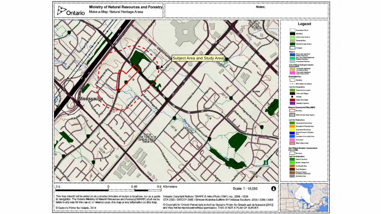
Subject Area and Study Area

APPENDIX D

Project: 15‐1151‐02 Limited Phase One Environmental Site Assessment, Square One Drive Extension, Rathburn Road West to
Confederation Parkway, Mississauga, Ontario
GeoPro Consulting Limited May 2017
Photo 1 – View of the Rathburn Road West and Elora Drive intersection (looking southeast)
Photo 2 – View of the parking lot and parking garage entrance for the two condominum
buildings at 350 Rathburn Road West (looking northeast)

Project: 15‐1151‐02 Limited Phase One Environmental Site Assessment, Square One Drive Extension, Rathburn Road West to
Confederation Parkway, Mississauga, Ontario
GeoPro Consulting Limited May 2017
Photo 3 ‐ View of the greenspace of 350 Rathburn Road West with Rathburn Road West on the
background (looking north).
Photo 4 – View of the tennis court at 350 Rathburn Road West (looking east).
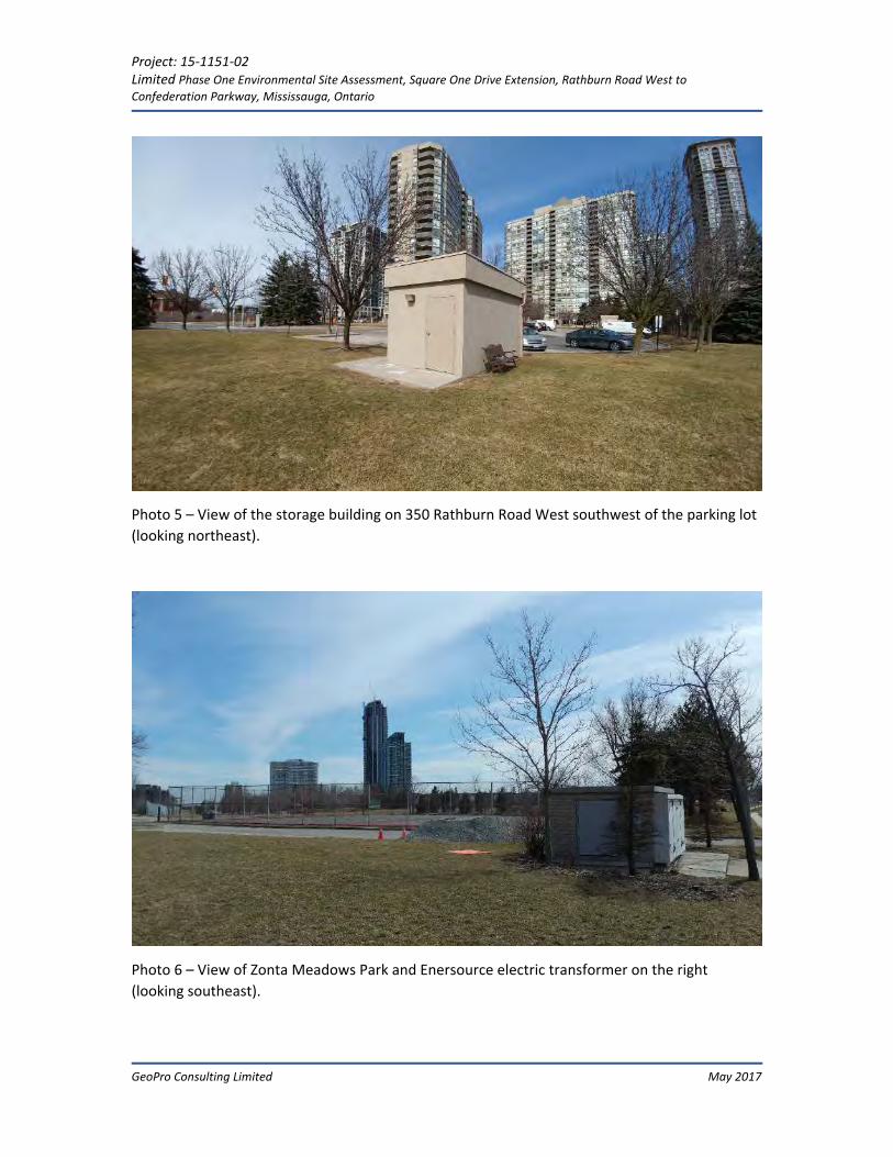
Project: 15‐1151‐02 Limited Phase One Environmental Site Assessment, Square One Drive Extension, Rathburn Road West to
Confederation Parkway, Mississauga, Ontario
GeoPro Consulting Limited May 2017
Photo 5 – View of the storage building on 350 Rathburn Road West southwest of the parking lot
(looking northeast).
Photo 6 – View of Zonta Meadows Park and Enersource electric transformer on the right
(looking southeast).

Project: 15‐1151‐02 Phase One Environmental Site Assessment, Proposed Square One Drive Extension from Rathburn Road West to Confederation Parkway, City of Mississauga, Ontario
GeoPro Consulting Limited April 2017
Photo 7 – Cable boxes and telecommunication hubs along Rathburn Road West (looking
northeast).
Photo 8 – View of Rathburn Road West from Rathburn Road West (looking southwest).

Project: 15‐1151‐02 Limited Phase One Environmental Site Assessment, Square One Drive Extension, Rathburn Road West to
Confederation Parkway, Mississauga, Ontario
GeoPro Consulting Limited May 2017
Photo 9 – Parking lot at Zonta Meadows Park (looking north).
Photo 10 – The tennis courts at Zonta Meadows park (looking west).

Project: 15‐1151‐02 Limited Phase One Environmental Site Assessment, Square One Drive Extension, Rathburn Road West to
Confederation Parkway, Mississauga, Ontario
GeoPro Consulting Limited May 2017
Photo 11 – View of three (3) transformer boxes on concrete pads at northeast of the Enersource
Hydro building (looking northwest).
Photo 12 – Northwest view of the Enersource Hydro building (looking southeast).

Project: 15‐1151‐02 Limited Phase One Environmental Site Assessment, Square One Drive Extension, Rathburn Road West to
Confederation Parkway, Mississauga, Ontario
GeoPro Consulting Limited May 2017
Photo 13 – View of the undeveloped/vacant land west of Conferation Parkway (looking
northeast).
Photo 14 – View of Zonta Meadow Park (looking southwest).

Project: 15‐1151‐02 Limited Phase One Environmental Site Assessment, Square One Drive Extension, Rathburn Road West to
Confederation Parkway, Mississauga, Ontario
GeoPro Consulting Limited May 2017
Photo 15 – Parking lot at southwest of the Enersource building (looking southeast).
Photo 16 – A ditch just southeast of the Enersource Facility parking lot running southeast within
the Study Area (looking north).

Project: 15‐1151‐02 Limited Phase One Environmental Site Assessment, Square One Drive Extension, Rathburn Road West to
Confederation Parkway, Mississauga, Ontario
GeoPro Consulting Limited May 2017
Photo 17 – View of Confederation Parkway roadway and mixed residential and multi‐tenant
commercial condominium building at 385 Prince of Wales Drive (looking east).
Photo 18 – Kleenlook Cleaners at 592 Rathburn Road West, the southwest corner of Elora Drive
and Rathurn Road West (looking south).

Project: 15‐1151‐02 Limited Phase One Environmental Site Assessment, Square One Drive Extension, Rathburn Road West to
Confederation Parkway, Mississauga, Ontario
GeoPro Consulting Limited May 2017
Photo 19 – Entrance of Corpus Christi School, south of the Subject Area at 550 Rathburn Road
West (looking east).
Photo 20 – View of Parkside Village Drive roadway construction (looking northwest).


![Clinical data successes - Joseph Paul Cohen...cat = [0 0 1 0 0 0 0 0 0 0 0 0 0 0 … 0] dog = [0 0 0 0 1 0 0 0 0 0 0 0 0 0 … 0] house = [1 0 0 0 0 0 0 0 0 0 0 0 0 0 … 0] Note!](https://img.pdfslide.us/doc/110x75/5fdf222a2dd17b0d95129a68/clinical-data-successes-joseph-paul-cohen-cat-0-0-1-0-0-0-0-0-0-0-0-0-0.jpg)


![[XLS]mams.rmit.edu.aumams.rmit.edu.au/urs1erc4d2nv1.xlsx · Web view0. 0. 0. 0. 0. 0. 0. 0. 0. 0. 0. 0. 0. 0. 0. 0. 0. 0. 0. 0. 0. 0. 0. 0. 0. 0. 0. 0. 0. 0. 0. 0. 0. 0. 0. 0. 0](https://img.pdfslide.us/doc/110x75/5ab434027f8b9a0f058b8cff/xlsmamsrmitedu-view0-0-0-0-0-0-0-0-0-0-0-0-0-0-0-0-0-0-0.jpg)

![[XLS] · Web view1101 0 0 0 0 11 0 0 12 0 0 13 0 0 14 0 0 15 0 0 16 0 0 17 0 0 18 0 0 19 0 0 51 1 1 0 0 81 2 0 0 3 0 0 0 0 0 0 0 0 0 0 0 0 0 0 0 0 0 1 1 0 0 2 0 0 3 0 0 0 0 0 0 0](https://img.pdfslide.us/doc/110x75/5ae8b1767f8b9a8b2b905346/xls-view1101-0-0-0-0-11-0-0-12-0-0-13-0-0-14-0-0-15-0-0-16-0-0-17-0-0-18-0-0-19.jpg)
![[XLS] · Web view0 0 0 0 0 0 0 0 0 0 0 0 0 0 0 0 0 0 0 0 0 0 0 0 7 2 0 0 0 0 0 0 0 0 0 0 0 5 4 0 0 0 0 0 0 0 0 0 0 0 5 4 0 0 0 0 0 0 0 0 0 0 0 5 4 0 0 0 0 0 0 0 0 0 0 0 5 4 0 0 0 0](https://img.pdfslide.us/doc/110x75/5aad015d7f8b9a8d678d9907/xls-view0-0-0-0-0-0-0-0-0-0-0-0-0-0-0-0-0-0-0-0-0-0-0-0-7-2-0-0-0-0-0-0-0-0-0.jpg)