Embed Size (px)
Citation preview

Subdivision Regulations
Amended by Board of Aldermen on September 18, 2018

City of Hernando Subdivision Regulations
b
This Page Intentionally Left Blank
City of Hernando Subdivision Regulations
i
Table of Contents
Table of Contents ............................................................................................................. i
Article I – Title and Purpose ............................................................................................ 1
Article II – Definitions ...................................................................................................... 2
A. General Definitions ................................................................................................ 2
B. Interpretation ......................................................................................................... 7
Article III – Jurisdiction .................................................................................................... 8
Article IV – Land Subdivision Procedure ........................................................................ 9
A. General Procedure ................................................................................................ 9
B. Major Subdivision Procedure ................................................................................. 9
C. Minor Subdivision Procedure ................................................................................. 9
D. Sketch Plat Procedure ......................................................................................... 10
E. Preliminary Plat Application Procedure ............................................................... 10
F. Data for Preliminary Plat ...................................................................................... 11
G. Final Plat Application Procedure ......................................................................... 13
H. Data for Final Plat ................................................................................................ 14
I. Procedure for Recording Final Plat ..................................................................... 15
J. Relation to Planned Unit Development (PUD) ..................................................... 15
Article V – Subdivision Design Standards ..................................................................... 17
A. Streets ................................................................................................................. 17
B. Easements .......................................................................................................... 18
C. Blocks .................................................................................................................. 19
D. Lots...................................................................................................................... 19
E. Public Sites, Facilities, and Open Spaces ........................................................... 20
F. General Suitability ............................................................................................... 21
G. Subdivision and Street Names ............................................................................ 21
H. Residential Development Pattern Book ............................................................... 21
Article VI - Required Minimum Improvements ............................................................... 22
A. Authority to Proceed with Installation of Improvements ....................................... 22
B. Procedures for Posting or Release of Bonds ....................................................... 22
C. Installation of Part of Improvements .................................................................... 23
City of Hernando Subdivision Regulations
ii
D. Survey Monuments ............................................................................................. 23
E. Minimum Standards............................................................................................. 24
F. Drainage .............................................................................................................. 27
G. Sidewalks ............................................................................................................ 28
H. Water Supply ....................................................................................................... 28
I. Sanitary Sewer System ....................................................................................... 28
J. Street Lights and Traffic Signs ............................................................................ 29
K. Street Signs ......................................................................................................... 29
L. Care of Area During Construction ....................................................................... 29
M. Erosion and Sediment Control ............................................................................. 30
Article VII – Revision of Recorded Plats ........................................................................ 32
A. Errors ................................................................................................................... 32
B. Revision of Plats .................................................................................................. 32
C. Vacation of Plats ................................................................................................. 32
Article VIII – Exceptions ................................................................................................ 33
City of Hernando Subdivision Regulations
1
Article I – Title and Purpose This ordinance shall be known, referred to, and cited as the Land Subdivision Ordinance of Hernando, Mississippi. The purpose of this ordinance is to provide for the coordination of streets within subdivisions with other existing or planned streets or with other features or lots or tracts, for requirements of the Preliminary and Final Plats; for minimum standards of physical improvements in new subdivisions; for adequate open spaces for traffic, utilities, firefighting apparatus, recreation, light and air, and for distribution of population and traffic all of which are to improve the health, safety, and general welfare of the community.
City of Hernando Subdivision Regulations
2
Article II – Definitions For this purpose, certain words and terms are herewith defined, words used in present tense include the future, the singular includes the plural and the plural includes the singular, the word "shall" is mandatory and not directory.
A. General Definitions
For the purpose of this Ordinance, words used in the present tense include the future, the singular number includes the plural, and the term "this Ordinance" shall be deemed to include all subsequent amendments.
1. ALLEY. A private or public way not more than twenty-five feet wide,
providing a secondary means of access to property.
2. APPLICANT. Any person as defined herein who makes application to the City of Hernando Planning Commission and Mayor and Board of Aldermen, or its designate for approval of a subdivision, building permit or partition plan.
3. BLOCK. The properties abutting on one side of a street between either: a. Two cross streets; or
b. Between the City limits and the nearest cross streets; or
c. When there is only one cross street:
(1) Between a cross street and the dead end of a street;
(2) Between a cross street and a line projected from the
centerline of an intersecting street, such as a "T" intersection;
(3) Between a cross street and a point 600 feet from the particular property under consideration when there is no other cross street or intersecting street within 600 feet; or
(4) When there are no cross streets, then the block shall be between the points 600 feet from each side of the property under consideration and along the street.
4. BOARD. Means the City of Hernando Mayor and Board of Aldermen. 5. BUILDING L I N E S . The l i n e s i n d i c a t e d on the subdivision plat, or
otherwise described, limiting the area upon which structures may be placed.
City of Hernando Subdivision Regulations
3
6. COMMISSION. The City of Hernando Planning Commission.
7. CENTERLINE. The legally described survey lines on which the street or road was initially established or to which the street or road was subsequently relocated.
8. CURB LINE. The line indicating the edge of the vehicular roadway within the overall right-of-way.
9. EASEMENT. The right to use or cross a parcel of land.
10. HOME OWNERS ASSOCIATION. A Home Owners Association is an organization formed for the maintenance and operation of the common areas of the development. The membership in the Association must be automatic with the purchase of a dwelling unit or other property in the development. The Association shall have the ability to legally assess each dwelling unit or other property, which assessment shall be enforceable as a lien against the property.
11. LAND DEVELOPMENT. The process of converting raw land into land that is construction ready for housing, commercial, or industrial building sites.
12. LAND DISTURBANCE. Any activity involving the clearing, cutting, excavating, filling, or grading of land or any other activity which alters land topography or vegetative cover.
13. LOT. A unit of land that is created by a subdivision or partitioning of land.
14. CORNER LOT. A lot or portion thereof situated at the intersection of two or more streets.
15. MAJOR PARTITIONING. A partition which includes the creation of a public or private road or street or the creation of a lot with less than 20 feet of frontage on a public road.
16. MAP. A final diagram, drawing or other writing concerning a major or minor partition.
17. MANUFACTURED HOME. A structure defined by, and constructed in accordance with, the National Manufactured Housing Construction and Safety Standards Act of 1974, as amended, and manufactured after June 14, 1976.
18. MOBILE HOME. A structure manufactured before June 15, 1976, that is not constructed in accordance with the National Manufactured Housing Construction and Safety Standards Act of 1974, as amended. It is a structure that is transportable in one or more sections, that, in traveling
City of Hernando Subdivision Regulations
4
mode, is eight (8) body feet or more in width and thirty two (32) body feet of more in length, or when erected on site, is two hundred fifty-six (256) or more square feet, and that is built on a permanent chassis and designed to be used as a dwelling with or without permanent foundation when connected to the required utilities, and includes any plumbing, heating, and air conditioning and electrical systems contained therein. The term "Mobile Home" shall not be deemed to include "Recreation Vehicle", "Modular Home" nor “Manufactured Home.”
19. MODULAR HOME. A structure which is: (i) built off-site in components or modules for later assembly on-site; (ii) transportable in one or more sections; (iii) designed to be used as a dwelling when connected to the required utilities, and includes plumbing, heating, air conditioning and electrical systems with the home; (iv) certified by its manufacturers as being constructed in accordance with a nationally recognized building code and locally adopted and enforced building codes; and (v) designed to be permanently installed at its final destination on an approved foundation constructed in compliance with a nationally recognized building code. The term "modular home" shall not be deemed to include "Mobile Home" nor “Manufactured Home”.
20. OPEN SPACE. An area within a development designed and intended for the use and enjoyment of all residents or for the use and enjoyment of the public in general. No thoroughfares or parking will be permitted in open space areas.
21. OWNER. The fee owner of real property as shown by the deed records of DESOTO COUNTY or a person who is purchasing real property under a recorded contract.
22. PARCEL. See LOT.
23. PARTITION. Either an act of partitioning land or an area or tract of land partitioned as defined in this section.
24. PARTITION LAND. To divide an area or tract of land into two or three parcels within a calendar year when such area or tract of land exists as a unit or contiguous units of land under single ownership at the beginning of such year, or to adjust a lot line by relocation of a common boundary. Partition land does not include division of land resulting from the creation of cemetery lots or lien foreclosures.
25. PERSON. A natural person, his heirs, executors, administrators, or assigns and also includes a firm, partnership or corporation, its or their successors, or assigns, or the agent of any of the aforesaid, and the State or any political subdivision, agency, board or bureau of the State.
City of Hernando Subdivision Regulations
5
26. PLANNED DEVELOPMENT. A subdivision of land incorporating common open space with each dwelling being placed on its own lot.
27. PLAT. Includes a final map, diagram, drawing, replat, or other writing containing all descriptions, locations, specifications, dedications, provisions and information concerning a subdivision.
28. SHALL. The term "shall" mean mandatory.
29. STREET OR ROAD. A public or private way that is or has been created to provide ingress or egress for persons to one or more lots, parcels, areas, or tracts of land, excluding a private way that is created to provide ingress or egress to such land in conjunction with the use of such land for forestry, mining, or agricultural purposes. The term "street" shall include thoroughfare as defined herein.
a. ARTERIAL. A highway primarily for through traffic, usually on a
continuous route. b. COLLECTOR. A road or street that accumulates traffic from minor
roads or streets and routes it to an arterial road or street. c. CUL-DE-SAC. A dead-end road or street with vehicular turnaround
at or near the dead end. d. DEAD-END STREET. The same as cul-de-sac with no turnaround
at the dead end. e. HALF STREET. A portion of the ultimate width of a road or street
where the remaining portion of the road or street shall be provided at a future date.
f. MINOR STREET. A road or street used primarily for access to
abutting property.
30. SUBDIVIDER. Any person who undertakes the subdivision of land.
31. SUBDIVIDE LAND. Means to divide an area of tract of land into four or more lots within a calendar year when such area of tract of land exists as a unit or contiguous units of land under a single ownership at the beginning of such year.
32. SUBDIVISION. Means either an act of subdividing land or an area or tract of land subdivided as defined in this section. The term subdivision shall include planned developments as defined herein.
City of Hernando Subdivision Regulations
6
33. THOROUGHFARE. Any vehicular way through the planned development or any vehicular way within the planned development. a. Minor thoroughfares are to serve specific property only, not the
general traffic circulation in the area, and need to be constructed only wide enough to adequately perform this function. Minor thoroughfares include "T" turnarounds, cul-de-sacs, circles, loops, and those "L" shaped streets not functioning as a through thoroughfare.
b. Major thoroughfares are publicly owned streets permitting traffic to move in one side of the planned development and out of another.
34. URBAN GROWTH BOUNDARY A mutually agreed upon boundary around
an incorporated County in DESOTO COUNTY which is included in the Comprehensive Plan or other adopted Plans by the incorporated municipalities within DESOTO COUNTY (one mile outside the city limits of Hernando).
35. UTILITIES. Any water, gas, sanitary or storm sewer, electrical, telephone, drainage way, wire, or television communication service and all persons, companies, or governmental agencies supplying the same.
36. UTILITY FACILITIES, OVERHEAD. All utility poles, overhead wires, and associated overhead facilities with the exception of: a. Antennae, associated equipment, and supporting structures used by
a utility for furnishing communication services.
b. Equipment appurtenant to underground facilities such as surface- mounted transformers and switchgear, pedestal-mounted terminal boxes, meter cabinets, concealed ducts, and municipal fire alarms, street lights, traffic control signals and poles used exclusively for such services as are served from an underground source of supply.
c. Temporary poles, overhead wires, and associated overhead facilities used in conjunction with construction projects.
d. High-capacity electric and communication feeder lines and utility transmission lines operating at 50,000 volts or more.
37. UTILITY FACILITIES, UNDERGROUND. All utility services that are placed
below ground level and covered with soil, sod, asphalt, or concrete for the intent of servicing a specific development or the general area.
City of Hernando Subdivision Regulations
7
B. Interpretation
For the purpose of this ordinance certain terms and words are hereby defined: 1. Words used in the present tense shall include the future tense. 2. Words in the singular number include the plural number, and words in the
plural number include the singular number. 3. The word "building" shall include the words "structure" and "premises". 4. The word "shall" is mandatory. 5. The word "may" is permissive. 6. The word "person" includes a firm, organization, association, partnership,
trust, company, or corporation as well as an individual. 7. The words "used" or "occupied" include the words "intended", "designed",
or "arranged" to be used or "occupied". 8. The word "lot" includes the words "plot", "tract", or "parcel".
City of Hernando Subdivision Regulations
8
Article III – Jurisdiction
A. It shall be unlawful for any individual being the owner, agent, or person having control of any land within the incorporated area of Hernando, Mississippi, to subdivide or layout such land in lots unless by a plat, in accordance with the regulations contained herein. No lots shall be sold nor any plat recorded until such plat has been approved as herein provided.
B. Any area hereafter annexed to the City of Hernando, immediately upon
annexation, shall no longer be subject to the DeSoto County Subdivision regulations adopted herein by the City of Hernando.
City of Hernando Subdivision Regulations
9
Article IV – Land Subdivision Procedure
A. General Procedure 1. Whenever any subdivision of land is proposed, before any recording of
deeds, and before any permit for the erection of a structure in such proposed subdivision shall be granted, the owner or his authorized agent, shall apply for and secure approval of such proposed subdivision in accordance with the following procedure, which includes three steps for a major subdivision and two steps for a minor subdivision:
a. Major Subdivision
i. Sketch Plat ii. Preliminary Plat iii. Final Plat
b. Minor Subdivision
i. Sketch Plat ii. Final Plat
2. Prior to final approval of any lot in City of Hernando which does not have central collection and treatment for sewage, an application, must be submitted to the DeSoto County Health Department for notation that septic tanks will be approved and any conditions or limitations for such approval.
3. No plat or replat subdividing land into lots shall be filed or recorded in the
Office of the DeSoto County Chancery Clerk, Mississippi, unless and until reviewed by the Planning Commission and approved by the Mayor and Board of Aldermen and no lot shall be sold from such plat or replat until the plat is filed for record in the Office of the DeSoto County Chancery Clerk.
B. Major Subdivision Procedure
The Subdivider of a Major Subdivision shall submit a Sketch Plat and a Preliminary Plat, except where waived by the Director of Planning, in accordance with the specifications of this Article. Upon approval of the sketch and preliminary plats, in accordance with this Ordinance, the Subdivider shall proceed with installation of the minimum improvements as required herein or may submit a final plat for approval by the Planning Commission in accordance with this Article.
C. Minor Subdivision Procedure
Any Subdivider of a Minor Subdivision shall submit to the Planning Commission one print of a Final Plat, drawn to scale by an Engineer or Land Surveyor licensed in the State of Mississippi (except where waived by the Director of Planning on 8
City of Hernando Subdivision Regulations
10
½" x 11" paper, containing the applicable information as shown in Article IV, Paragraph H). If the proposed minor subdivision is not in violation of any existing applicable statutes or regulations approval may be given by the Director of Planning of the City of Hernando. The recommendation will then be presented to the Mayor and Board of Aldermen for final determination. In the event the Director of Planning disapproves the proposed Minor Subdivision Final Plat, the Subdivider can appeal to the full Planning Commission. Minor subdivision plats are not required to be recorded in the plat books of the City of Hernando City Clerk's Office; however, approval of such subdivision must be recorded in the minute books of the Mayor and Board of Aldermen, and the required Right-of-Way, as indicated in the Subdivision Design Standards contained in Article V.A.5. must be conveyed to City of Hernando by Right-of-Way deed. Said Right-of-way shall be counted in the computation of minimum lot size.
D. Sketch Plat Procedure
1. The purpose of the Sketch Plat is to provide the Subdivider an opportunity to consult early and informally with the Planning Department before preparation of a Preliminary and/or Final Plat and submission of a formal application to the Planning Commission. The intent of this procedure is to assist the Subdivider in preparing a plan which will meet the objectives of the General Development Plan, the requirements of the Planning Commission and of other public agencies, the improvements and uses of the subdivision and any other potential problems involved in the proposed subdivision.
2. The Subdivider shall submit to the Planning Department a Sketch Plat
showing the boundaries of the proposed subdivision, its relationship to surrounding properties, natural features and the proposed street and lot pattern. This step does not require a formal application or filing fee. Upon receipt of the Sketch Plat the Planning Department shall review the Sketch Plat, and notify the Subdivider through consultation and/or writing that the Sketch Plat as submitted, or modified, meets the objectives of these regulations, or does not meet the objectives of these regulations and the reason therefore.
E. Preliminary Plat Application Procedure 1. Application shall be made online in digital format (PDF) through the City’s
Permitting website. The Plat shall be drawn to a scale of 100 feet to the inch, except where waived by the Director of Planning, conforming to the requirements of Article IV.F, shall be submitted to the Planning Commission. The plat shall be accompanied by an application form supplied by the Planning Department and a filing fee to be fixed by the Mayor and Board of Aldermen by separate ordinance. Application shall be made no later than the Planning Commission submittal deadline which is the Friday immediately
City of Hernando Subdivision Regulations
11
following the second Tuesday of each month.
2. If the Planning Commission, after the recommendation of the Director of Planning, finds that the preliminary plat satisfies the requirements of this Ordinance, it shall approve said plat. The Subdivider or his agent must be present at the Planning Commission meeting scheduled to hear the submitted application unless otherwise advised by the Director of Planning.
3. If the Planning Commission finds otherwise, it shall specify the objections
found to such plat and may either disapprove or approve the plat conditional upon specific changes being made to the plat prior to its submission to the Mayor and Board of Aldermen.
4. Within 90 days after submission of the preliminary plat and other required
materials submitted in conformity to these regulations, the Planning Commission shall specify to the Subdivider its approval and state the conditions of such approval, or in the event of disapproval, shall state its disapproval and reasons therefore. However, the Subdivider may waive the time limitation requirements and consent to an extension of such period.
5. The Planning Commission may attach additional conditions not specified in
this ordinance and reject a subdivision if it has been determined that the proposed subdivision is not in keeping with the general character of the development in the area; and that in the best of the public, the site is not suitable for the proposed development purposes.
6. When requested, one copy of the proposed plat and findings of the Planning
Commission shall be given the person offering the proposed plat, together with a certificate of approval or disapproval of the Planning Commission. Approval of the Preliminary Plat by the Planning Commission does not constitute a final acceptance or approval of the proposed subdivision.
7. On the basis of approval of the Preliminary Plat, the Subdivider may proceed
with the installation of minimum improvements as outlined in Article VI of this ordinance with reasonable assurance that no major changes will be required or made at a later stage of the approval process. Upon completions of the minimum improvements, acceptance of the improvements by the City, and posting a surety for said improvements, the Subdivider may proceed toward filing a Final Plat, as described in Article IV.G.
F. Data for Preliminary Plat The Preliminary Plat shall be at a scale of One hundred (100) feet to one (1) inch (1" = 100') unless otherwise specified by the Planning Department. The Preliminary Plat and accompanying documents shall show the following:
City of Hernando Subdivision Regulations
12
1. The proposed lot lines, lot numbers, and the lot layout for the subdivision. 2. Minimum building setback lines. 3. The location of all existing and proposed streets, alleys, or access
easements in the subdivision including dimensions of rights-of-way widths, street names.
4. Easements, their location, width, and purpose. 5. The proposed use of all land in the subdivision including any reserved areas
and the acreage. 6. The location of existing property lines, streets, buildings, water courses,
zoning classifications, and other existing features within the area to be subdivided and similar information regarding existing conditions of land immediately adjacent thereto.
7. The acreage of the land to be subdivided. 8. Areas which are subject to periodic inundation (100-Year Flood Elevation). 9. The proposals for sewer and water service shown as a note on plat and any
accompanying documentation from appropriate agencies. 10. The title under which the proposed subdivision is to be recorded, and the
name and Mississippi registration number of the Engineer, Registered Land Surveyor, Planner, the Subdivider platting, the number of lots, and the section, township, and range.
11. Location sketch map showing relationship of subdivision site to area
including township, range, section, and parts of sections. 12. The names and adjoining boundaries of all adjoining subdivisions and the
names of recorded owners of adjoining parcels of unsubdivided land. 13. Contours at vertical intervals of not more than two feet will be shown for
property to be platted as school or park sites. 14. North point, graphic scale, and date. 15. The Subdivider's proposal to the Mayor and Board of Aldermen for
accomplishing the installation of improvements in accordance with Article VI of the Ordinance.
City of Hernando Subdivision Regulations
13
G. Final Plat Application Procedure 1. Seven prints at a scale of one inch equals 100 feet accompanied by an
application form supplied by the Planning Department, a filing fee to be fixed by the Mayor and Board of Aldermen by separate ordinance, together with copies of any deed restrictions where such restrictions are too lengthy to be shown on the plat, shall be submitted to the Planning Department. Application must be made no later than one (1) month prior to the next regularly scheduled meeting of the Planning Commission to be heard at that meeting.
2. When the Final Plat conforms to the approved Preliminary Plat, and the
requirements of this Article have been accomplished, the Final Plat shall be approved by the Planning Commission and the plat thereupon submitted to the Mayor and Board of Aldermen for its review and final determination. When the Final Plat does not conform to the approved Preliminary Plat, the Planning Commission shall submit its recommendations to the Mayor and Board of Aldermen for approval or disapproval of the Final Plat. The Subdivider or his agent must be present at the Planning Commission meeting scheduled to hear the submitted application unless otherwise advised by the Director of Planning.
3. If the subdivision improvements required in Article VI have not already been
installed as explained in Article IV. E. 7., the Subdivider may either; a. Proceed to install the required improvements before subdivision may
be recorded and lots sold: or b. A performance bond must be provided to cover the costs of the
required improvements and the subdivision may be recorded immediately and lots sold. Once the improvements have been installed, a maintenance bond must be provided as described in Article VI. B.4. after which the performance bond is released.
c. After approval of the Final Plat by the Mayor and Board of Aldermen
and required improvements are installed or appropriate arrangements have been made therefore, a Mylar original plat shall be recorded in the Office of the Chancery Clerk within one (1) year, and if not filed, such plat shall have no validity and shall not be recorded without concurrence of the Planning Commission. A Mylar copy of the recorded plat shall be provided to the Planning Department for its official records.
d. Any land dedicated to the City of Hernando for park purposes in a
subdivision shall be conveyed to the City of Hernando free and clear of all encumbrances at the same time the plat of subdivision is filed,
City of Hernando Subdivision Regulations
14
said deeds to be without restrictions or covenants except requirement that the land be used for park purposes without reversion and with references to the subdivision, if any, on which the land is shown.
H. Data for Final Plat
1. The Final Plat shall be at a scale of not more than 100 feet to the inch (1" = 100') from an accurate survey and on one or more sheets whose dimensions shall be 18 inches by 24 inches (18”x24”). If more than two sheets are required, an index sheet of the same dimensions shall be filed showing the entire subdivision on one sheet and the component areas shown on other sheets. The Final Plat and the accompanying documentation shall show the following: a. The boundary lines of the area being subdivided with accurate
distances and angles, showing all relationship of the subdivision to section, township and range.
b. The lines of all proposed streets their widths and the names of all
streets. c. The accurate outline of any portions of the property intended to be
dedicated or granted for public use with a statement of dedication thereon.
d. The lines of all adjoining property and the line of adjoining streets and
alleys with their widths and the names of all streets within the proposed subdivision.
e. All lot lines together with an identification of all lots which shall be
numbered consecutively (including common areas which shall be assigned a lot number and the C.O.S. designation, i.e. Lot 70 C.O.S.).
f. The location of all building lines and easements g. All dimensions, both linear and angular, necessary for locating the
boundaries of the subdivision, lots, streets, alleys, easements, and other areas for public or private use. Linear dimensions are to be given to the nearest 1/ 100th of a foot.
h. The radii, arcs or chords, points of tangency, and central angles for
curvilinear streets and radii for rounded corners. i. The location of all survey descriptions as provided in Article VI – D.
j. Common open space used for the cluster mailboxes shall be included
City of Hernando Subdivision Regulations
15
on the plat.
2. General Information - The Final Plat shall show the following: a. The name of the subdivision, a graphic scale of the plat, a north arrow
oriented toward the top of the page, the date and the name of the Owner or Owners or Subdividers.
b. Location sketch map showing relationship of subdivision site to area
including township, range, section, and parts of sections. c. The certificate, Mississippi registration number, and legal seal of a
registered engineer or land surveyor attesting the accuracy of the survey and the correct location of all monuments shown.
d. Private restrictions and trusteeships and their periods of existence.
Should these restrictions or trusteeships be of such length as to make their lettering on the plat impracticable and thus necessitate the preparation of a separate instrument, reference to such instrument shall be made on the plat.
e. Acknowledgment of the owner or owners of the plat, and restrictions
including dedication to public use of all streets, alleys, parks, or other open spaces shown thereon and the granting of easements required.
f. Proper certificates for owner, notary public, registered engineer or
land surveyor, Planning Commission, Mayor and Board of Aldermen, City Clerk, and Chancery Clerk, shown in that order.
I. Procedure for Recording Final Plat After final approval is obtained from the Mayor and Board of Aldermen and all conditions have been satisfied, two Mylar copies and one print shall be submitted for recording which shall contain the necessary signatures, certificates, and seals as specified in Article IV.H.2. along with any agreements and bonds, if necessary, a recording fee as established by the Office of the DeSoto County Chancery Clerk, an MDEQ permit, and the attorney's certificate of title certifying title to the land subdivided valid as of the hour and day of recording. Additionally, the developer shall submit a CD with the plat in DWG format and a list of addresses for each lot that has been approved by local E-911 agency.
J. Relation to Planned Unit Development (PUD)
Any portion of a tract zoned as a PUD District may be submitted for approval as a major subdivision, provided that the PUD District zoning regulations governing the approval of a Preliminary Site Plan are met. In submitting any PUD subdivision for
City of Hernando Subdivision Regulations
16
approval, the prior action of the Planning Commission and the Mayor and Board of Aldermen in granting the zoning application shall be sufficient preliminary plat approval within the meaning of Article IV. No preliminary plat specified in Article IV shall be required.
The basic purpose of PUD is to allow flexibility in the development of planned communities. PUD is intended to facilitate total density control of an alternative to regulation of individual lot size, harmonious development standards for minimum improvements, and development of attractive and functional common areas for recreational and other purposes. Within the general limitations of the General Development Plan, the intent of these regulation and the public interest, convenience, safety and welfare, the Planning Commission may consider this purpose and may waive or modify any requirements of Article V and VI of these regulations.
City of Hernando Subdivision Regulations
17
Article V – Subdivision Design Standards
A. Streets 1. The arrangement of streets in all new subdivisions shall make provisions for
the continuation of the principal existing streets in the adjoining areas or their proper projection and for any streets or roads shown on the Future Land Use and Transportation Plan for The City of Hernando.
2. All proposed street names shall avoid duplication of other street names in
the City of Hernando unless the proposed street is obviously intended as an extension of another existing or proposed street, in which case the streets shall bear the same name.
3. The arrangement of streets and lots shall give due regard to topography and
other physical features of the property. 4. The right-of-way widths and location of major and collector streets shall
conform to the right-of-way widths and locations of such streets designated on the Future Land Use and Transportation Plan. However, the Planning Commission may consider any other proposed street a major or collector street and require comparable right of-way widths.
5. The minimum widths of street and road right-of-way, measured from lot line
to lot line, shall be as shown on the Future Land Use and Transportation Plan for Hernando, or if not shown on such plan, shall not be less than the following:
Street TypeRight-of-Way
(in feet)
Major or Arterial 4 lanes with median or turn lane, parking 1064 lanes with median or turn lane, no parking 90 4 lanes with no parking 80 4 lanes with shoulders and ditches (rural) 106
Collector 106Commercial, Industrial, and multi-family residential
68
One and two-family residential areas 60
Minor / Local 50
Alley 20
The minimum right-of-way width for minor/local streets shall be 50 feet, except that in cases where the topography or special conditions make right-of-way of less width more suitable, the Planning Commission may waive the above requirement.
City of Hernando Subdivision Regulations
18
6. The angle of intersection between streets should not vary by more than ten
degrees (10º) from a right angle.
7. The minimum corner radii at street intersections shall be twenty (20) feet. 8. Street "jogs" resulting from failure to align streets on either side of an
intersection are prohibited, with a minimum offset of 150 feet between center lines of parallel streets being required.
9. Cul-de-sac streets may be provided if proper access is given to all lots from a dedicated street or court. All cul-de-sac streets shall terminate in a dedicated right-of-way space having a minimum radius of 50 feet, or other satisfactory arrangement for turning of vehicles. Cul-de-sac streets shall not exceed 500 feet in length.
10. Minimum street grades of 0.5 percent will be required for adequate drainage;
maximum street grades will be 7 percent for all streets. Intersections will be a minimum feasible grade with sight distance of at least 100 feet in all directions. A minimum sight distance of 200 feet will be required in all curves.
11. In industrial or commercial subdivisions, paved alleys or driveway
easements assuring permanent rear access may be required with a minimum width of 20 feet.
12. To assure a continuous circulation system in an area when all the land is
developed the Planning Commission may require extension of a street within a subdivision to the adjoining property, which street would be continued at the time the adjoining property would be developed. Temporary turnaround with a forty (40) foot radius shall be provided at the termination of such streets unless waived by the Planning Commission.
B. Easements 1. Easements of at least ten (10) feet in width shall be dedicated on each side
of all rear lot lines and at least five (5) feet on each side lot line and at least ten (10) feet on all lot lines adjoining a street, for poles, wires, conduits, storm and sanitary sewers, gas, water, or other utilities. The developer shall confer with all utility companies serving the property. Easements of greater width than normally required may be required as necessary.
2. No side, rear, or front yard easements will be required where the Hernando
Zoning Ordinance indicates no yard requirements. 3. Whenever any stream or important surface drainage course is located in an
City of Hernando Subdivision Regulations
19
area which is being subdivided, the Subdivider shall provide an adequate easement along each side of the stream for the purpose of widening, deepening, sloping, improving, or protecting the stream or drainage course. The adequacy of the easement shall be determined by the City Engineer.
C. Blocks All new blocks created by any major subdivision of land shall take into consideration the following: 1. All blocks shall be sufficiently wide to allow two tiers of lots of appropriate
depth under the applicable zoning regulations, unless another length or width is approved by the Planning Commission because of special topographical or traffic considerations.
2. No block shall be less than 250 feet nor more than 1,500 feet in length except as the Planning Commission considers necessary to secure efficient use of land or desired features of street patterns.
3. Mid-block walkways or crosswalks, not less than ten (10) feet wide may be required where deemed essential to improve pedestrian circulations or access to schools, shopping centers, parks, playgrounds, or other community facilities.
D. Lots
1. The lot arrangement and design shall be such that all lots will provide satisfactory and desirable building sites properly related to topography and to the character of surrounding development.
2. The minimum lot area and lot width measured at the building lines shall
conform to the requirements of the zoning ordinance for the applicable zoning district.
3. No lot shall have a depth in excess of four times its width, however this
requirement may be waived by the Planning Commission if the Subdivider can demonstrate this requirement is not appropriate for the type of development and use contemplated
4. All side lot lines shall be at right angles to straight street lines and radial to
curved street lines a variation of this rule will provide a better street and lot layout as approved by the Planning Commission.
5. Corner lots shall have a width sufficient to permit the establishment of front
building lines on both the adjoining streets without reducing the buildable width below that of the average sized lot in the subdivision.
City of Hernando Subdivision Regulations
20
6. Reverse frontage lots shall be prohibited except where essential as
determined by the Planning Commission to provide separation of residential development from traffic arteries or to overcome specific disadvantages of topography. In such cases, additional depth including a planting screen reservation of a minimum of ten (10) feet in width, and across which there shall be no right of access, shall be provided along the line of lots abutting such uses. A statement dissolving the right of access of lots to the major street shall be included on the Final Plat.
7. Property line radii at street intersections shall not be less than twenty 20 feet.
E. Public Sites, Facilities, and Open Spaces 1. Adequate park, school, and recreational space shall be provided at
convenient locations throughout the subdivision and conform to the Hernando Comprehensive Plan. The amount, type, and locations of such areas will depend on the size and type of development and shall be developed in accordance with the location, space, and size requirements presented in Volume II of the Hernando Comprehensive Plan.
2. Where park, playground, or areas for other public recreational uses should be provided in the subdivision in accordance with the Comprehensive Plan, the Planning Commission may require such area to be dedicated to the proper public agency. Where a school should be provided in accordance with the Comprehensive Plan, the Planning Commission may require such area to be dedicated to the proper public agency or be reserved for acquisition by said agency within one year. Such reservation shall continue in effect for a period of not more than one (1) year from the date of filing of the Preliminary Plat. This reservation period may be extended for a period not to exceed six (6) months upon submission of a letter to the Planning Commission of intent to purchase by the appropriate governmental agency. This reservation may be discontinued upon written notice from the appropriate governmental agency stating that the property may be released for development.
3. All land to be reserved for dedication to the local government or acquisition
for public use purposes shall have prior approval of the appropriate governmental agency and shall be shown on the plat "Reserved for Park and/or Recreation and/or Public Use Purposes.
4. Where a subdivision contains sewers, sewage treatment plants, water
supply systems, park areas, or other physical facilities necessary or desirable for the welfare of the area and of common use or benefit, which the Mayor and Board of Aldermen does not desire to or cannot maintain, provision shall be made for the proper and continuous maintenance and
City of Hernando Subdivision Regulations
21
supervision of such facilities by the lot owners in the subdivision.
F. General Suitability
1. The Planning Commission may reject a subdivision if it has been determined that the proposed subdivision is not in keeping with the general character of the development in the area; and that in the best interest of the public, the site is not suitable for the proposed development purposes.
2. Where deed restrictions or covenants are proposed, they shall be included
with the plat and made a part of such plat provided however, that such deed restrictions or covenants shall not contain reversionary clauses wherein any lot shall return to the Subdivider because of a violation thereon of the terms of the restrictions or covenants.
3. Land which is shown as within the "Flood Control District" on the official
Zoning District Map shall not be platted for residential or any other use which may result in danger to health, life, or property or increased flood heights; unless the Subdivider submits to the Planning Commission that the area can be protected from inundation, by fill, levee, or other means without undue interference either with the flow of any water course or with any necessary impounding basin, which evidence shall be verified by the City Engineer. The elevation and extent of flooding in each drainage area shall be established by the City Engineer and shall be indicated on both the Preliminary and Final Plats.
G. Subdivision and Street Names 1. The proposed name of the subdivision and street names shall not duplicate, or
too closely approximate phonetically, the name of any other subdivision or streets in Hernando.
H. Residential Development Pattern Book
1. Any proposed subdivision containing more than nineteen (19) lots shall provide a pattern book illustrating in detail the character of proposed architecture, fences, accessory buildings, and any other graphic element including, but not limited to street signs, light facilities, identification signs, etc.
City of Hernando Subdivision Regulations
22
Article VI - Required Minimum Improvements
A. Authority to Proceed with Installation of Improvements 1. Receipt by the Subdivider of the approval of the Preliminary Plat by the
Planning Commission shall constitute authority for the Subdivider to begin preparation of the following minimum improvements and preparation of the Final Plat. The Subdivider shall:
a. Submit final construction plans and specifications to the City Engineer
through the Office of Planning prior to construction of any of the required improvements or the submission of a performance bond.
b. Submit engineering maps showing approximate grades and profiles of
streets and plans regarding facilities for storm water drainage and other proposed improvements such as sidewalks, plantings, parks, and any grading of individual lots except when specifically not required by the Planning Commission.
2. If the Engineer shall find such plans and specifications to be in accordance
with applicable policies and standards of the Mayor and Board of Aldermen, he shall authorize construction and determine the amount of bond, if required. Following the approval of the plans and specifications, construction may be started or the bond may be filed.
3. All improvements must be inspected during the course of construction of the improvements. A schedule of inspections must be coordinated with the City Engineer. The City Engineer will make written inspection reports during the period of construction.
B. Procedures for Posting or Release of Bonds
1. No Final Plat of any subdivision shall be recorded unless all improvements specified in the approval have been completed or a performance bond has been filed with the Mayor and Board of Aldermen securing the construction of improvements specified in this Article.
2. The Subdivider shall sign an agreement with the Mayor and Board of
Aldermen agreeing to install or provide the required improvements and shall file with the Mayor and Board of Aldermen a bond. This agreement and bond shall be conditional to secure the construction of the required improvements listed in this Article in a satisfactory manner and within a period specified by the Mayor and Board of Aldermen, such period not to exceed two (2) years. No such bond shall be accepted unless it is enforceable by or payable to the city of Hernando in a sum at least equal to the amount specified below and in a form with surety and conditions
City of Hernando Subdivision Regulations
23
approved by the Attorney for the Mayor and Board of Aldermen, where costs of improvements are not specified, this amount shall be estimated by the City Engineer.
3. The bond amount for streets shall be determined by the City Engineer and
shall be a sum at least equal to the amount estimated to construct the required improvements to the required specifications two (2) years from the date of the agreement.
4. All road construction will be guaranteed after acceptance by the City of
Hernando subject to normal wear and tear. A maintenance bond in an amount set by the City Engineer will be required in order to assure the satisfactory condition of the required improvements. The maintenance bond shall continue to be in effect until 25% of the lots in that section of the subdivision are built on or one (1) year whichever time is greater.
5. When all of the required improvements have been constructed, the
Subdivider shall contact the City Engineer for a final inspection and shall provide certification that the final improvements have been installed according to City specifications. The City Engineer shall inspect the subdivision and make a written report, a copy of which is to be provided to the Subdivider and the Mayor and Board of Aldermen.
6. The bond will be released by order of the Mayor and Board of Aldermen
when the subdivision receives an approved final inspection report from the City Engineer. The Mayor and Board of Aldermen on recommendation of the City Engineer may reduce liability on the bond as work progresses and after acceptance may reduce the bond to such amount as the City Engineer deems sufficient to guarantee performance of the warranty.
C. Installation of Part of Improvements The owner of a tract may prepare and secure approval of a Preliminary Plat for the entire tract and the required improvements in only a portion of such tract, but the improvements must be installed or provision made for their installation in any portion of the area for which a Final Plat is approved for recording. This is provided, however, that any gas mains, storm sewers, trunk sewers, and any sewage treatment plants shall be designed and built to serve all the area owned by the Subdivider or designed and built in such a manner that they can easily be expanded or extended to serve the entire area and provided further that the requirements of Article V.E.2. have been met. and provided further that the require-
D. Survey Monuments
All subdivision boundary corners shall be marked with permanent monuments. A permanent monument shall be deemed to be a four (4) inch by four (4) inch concrete
City of Hernando Subdivision Regulations
24
post at least thirty (30) inches long with a one-half (½) inch steel rod center. Should conditions prohibit the placing of monuments on the line, offset marking will be permitted, provided however, that exact offset courses and distances are shown on the subdivision plat. Iron pipes or steel rods shall be set at all lot corners. If survey monuments are removed during construction, they shall be replaced.
E. Minimum Standards The owner shall submit to the City Engineer through the Office of Planning two (2) complete sets of plans and profiles of roadwork to be constructed in the subdivision. The City Engineer may require the owner to lay grades and designate size of drains to be used before considering the same and may make any changes he deems necessary to conform to good engineering practice. The owner will furnish the City Engineer a topographical map of the area to be subdivided when required by him, so that he may be able to study drainage requirements. Contours on the map shall be on two-foot intervals from actual elevation.
1. Street Improvements
All existing and new roads, regardless of lot size must comply with these regulations before dedication is accepted and before the roads will be maintained by City of Hernando. a. Depth of Soil Cement: Residential subdivisions shall have a minimum
of six (6) inches of soil cement using minimum of ten (10%) percent cement by volume and three (3) inches of asphalt surface coarse. Commercial and industrial subdivisions shall have a minimum of eight (8) inches of soil cement using minimum of ten (10%) percent cement by volume and three inches of asphalt surface coarse.
b. Width of Soil Cement: (1) 50' R.O.W. roads shall have thirty feet (30’) of soil cement. (2) 60' R.O.W. roads shall have forty feet (40’) of soil cement. (3) All 68' and 80' R.O.W. roads shall have forty-eight feet (48') of
soil cement.
c. Use of Clay Gravel Base - an alternative road base using compacted clay gravel may be approved. Said base shall have a compacted depth of eight (8) inches for residential subdivisions and twelve (12) inches for commercial and industrial subdivisions. Where needed as an arterial road, the soil cement thickness and width may be
City of Hernando Subdivision Regulations
25
increased by the City Engineer.
d. Width of Pavement: (1) 50' R.O.W. roads (streets, lanes, drives, etc.) shall have thirty
feet (30’) of pavement or twenty-four feet (24’) when there is no curb and gutter
(2) All major thoroughfares, as determined by the planning
commission and/or illustrated on the major thoroughfare plan, shall provide for five-lane road/street cross sections.
(3) All other roads (streets, lanes, drives, etc.) shall have
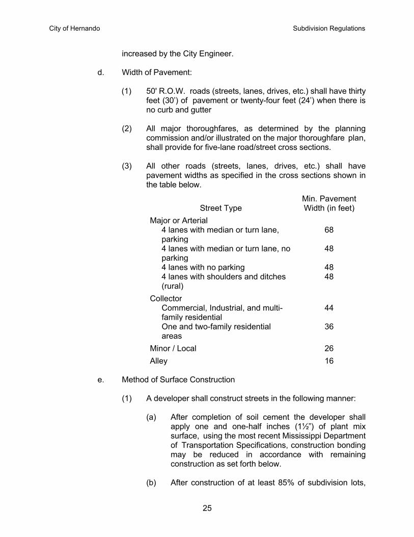
pavement widths as specified in the cross sections shown in the table below.
Street TypeMin. Pavement Width (in feet)
Major or Arterial 4 lanes with median or turn lane, parking
68
4 lanes with median or turn lane, no parking
48
4 lanes with no parking 484 lanes with shoulders and ditches (rural)
48
Collector Commercial, Industrial, and multi-family residential
44
One and two-family residential areas
36
Minor / Local 26
Alley 16
e. Method of Surface Construction
(1) A developer shall construct streets in the following manner:
(a) After completion of soil cement the developer shall apply one and one-half inches (1½”) of plant mix surface, using the most recent Mississippi Department of Transportation Specifications, construction bonding may be reduced in accordance with remaining construction as set forth below.
(b) After construction of at least 85% of subdivision lots,
City of Hernando Subdivision Regulations
26
plant mix surface shall be applied. Plant mix surface shall be applied at one and one-half inches (1½”) in thickness, using the most recent Mississippi Department of Transportation Specifications. The Developer’s construction of streets shall require certification of compliance with construction standards by an engineer licensed in the State of Mississippi. Certification of construction standards will allow for the reduction of the construction bond to a one-year maintenance bond.
(c) The issuance of building permits shall cease for failure
to fully comply with the standards herein stated.
f. All new roads must be paved by the Developer before being accepted by the Mayor and Board of Aldermen for maintenance. Three inches of plant mix surface, using the latest Mississippi State Highway Specifications is required on all new roads in subdivisions. Any changes from these specifications must be approved by the City Engineer and tests may be required on all materials. The latest edition of Mississippi Department of Transportation Specifications will govern construction.
g. All bridges shall be constructed according to the Mississippi Standard Specifications for State Aid Road and Bridge Construction in effect at the time the subdivision is approved.
h. The Subdivider shall dedicate and construct all minor and collector
streets for full width of right-of-way as defined in Article V.A.5. Where the developer is developing a subdivision that runs to or along the center of a major or arterial street, he will be required to dedicate and develop only one-half (½) of said road. However, in no case shall less than twenty (20) feet of wearing surface be required when one-half (½) of the right-of-way is dedicated.
i. Curb and gutter will be installed in all residential, commercial, and
industrial zoned subdivisions using the Mississippi State Highway Specifications. The developer shall have material and compression tests of the concrete performed and the results submitted to the Engineer. In residential, industrial, and commercial subdivisions in rural areas, curb and gutter requirements shall be of such character as is suitable for the expected traffic and in harmony with similar improvements in the surrounding area, as determined by the City Engineer.
j. The Developer's engineer must notify the City Engineer in writing
when the subgrade is ready for soil cement stating all culverts,
City of Hernando Subdivision Regulations
27
subgrade width, and firmness of subgrade are up to approved engineering standards before gravel is placed on the road. The Owner shall notify the City Engineer when he plans to place soil cement on the road. The City Engineer may have a representative present if load measurement is to be used. After the soil cement is placed, the City Engineer will again certify that the soil cement is of proper material thickness and width. When the road is to be paved, the City Engineer again will certify as to roadbed being in proper condition for surfacing and that the materials used meet standards. The City Engineer or his representative will inspect the road one time after being notified at completion of each phase of this work at no cost to the owner. If another trip is made, there will be a per hour charge for time involved on all other trips.
k. If these standards are not carried out, the City of Hernando Board of
Aldermen will not accept the roads for maintenance.
F. Drainage 1. The plat shall be laid out so as to provide proper drainage of the area being
subdivided. Drainage improvements shall maintain any natural watercourse and shall prevent the collection of water in any low areas
2. All drainage pipes may be concrete, asphalt coated metal pipes, or plain
galvanized-coated metal pipes. The City Engineer must approve the gauge thickness of asphalt-coated metal pipes or plain galvanized metal pipes. All plain galvanized pipes approved by the Engineer for the sizes twenty-one (21) inches through ninety-six (96) inches in diameter shall be one gauge heavier than the approved gauge for asphalt-coated metal pipe. The Developer's Engineer shall provide the City Engineer with the shipping tickets showing the gauge of all pipes installed.
3. The Planning Commission upon recommendation of the City Engineer may
require paving of ditches or appropriate stabilization. Sufficient easements will be provided on subdivision plats for maintenance of large ditches for alignment and cleaning. Ditches shall be constructed on uniform grades sufficient for proper run-off.
4. All underground drainage must be inspected and approved by the City
Engineer. 5. All driveway culverts and ramps shall be provided for by the Subdivider. The
cost of culverts and ramps shall be included within the performance bond for the Subdivider with the number of culverts and cost being approved and estimated by the City Engineer. Upon installation of any culverts or ramps by the Subdivider, the performance bond may be reduced or a new bond
City of Hernando Subdivision Regulations
28
substituted to secure the obligation with respect to culvert and ramp requirements.
G. Sidewalks
1. Concrete sidewalks not less than five (5) feet wide and four (4) inches in depth shall be constructed along both sides of all major and collector streets with curbs and gutters in accordance with applicable standard specifications of the City. Sidewalks shall be constructed along at least one side of every minor street shown on the plat with the exception of cul-de-sac where sidewalks are not required.
2. The Mayor and Board of Aldermen may waive the above requirement for
sidewalks provided that street rights-of-way are left unobstructed and graded in such manner that sidewalks may be constructed at a later date.
3. Material and compression tests of the concrete shall be performed and
submitted to the City Engineer.
H. Water Supply All subdivisions shall have the proposed water system approved by the appropriate state agencies. The water system shall have enough outlets and shall be large enough to furnish an adequate water supply and fire protection to every lot. 1. Water mains, where possible, shall be located in street rights-of-way as
approved by the City Engineer. 2. The installation of the water system, including fire hydrants, shall be subject
to the approval of the Mayor and Board of Aldermen and City Engineer. 3. Fire hydrants shall be installed in all sub division except where the water
system serving that subdivision is not adequate. The hydrants shall be located not more than five hundred (500) feet as measured along a dedicated street from all lots within the subdivision. All fire hydrants will be served by a six (6) or larger
I. Sanitary Sewer System 1. Centralized sewage collection and treatment facilities shall be provided on
all lots in all subdivisions except as hereafter provided, and shall conform to all applicable state and local laws.
2. Where centralized public sewage collection systems are not reasonably accessible to the Subdivider and an individual centralized disposal system is provided by the Subdivider, sewer lines shall be laid out so a future
City of Hernando Subdivision Regulations
29
connection with the public sewer main shall be made. All plans shall be designed and approved in accordance with the rules, regulations, and standards of the Mississippi State Board of Health. Necessary action shall be taken by the Subdivider to extend or create a sanitary sewer district which will maintain the disposal system.
3. Individual septic tanks may be used in subdivisions where central sewage is not available only if written approval is obtained from the Mississippi State Board of Health.
4. All subdivisions hereafter filed for record in the Office of the Chancery Clerk shall be approved only for use with central collection and treatment of sewage unless there is affixed to the plat a notation signed on behalf of the Health Department that septic tanks may be used on the lots. Developers contemplating use of central collection and treatment need not submit such plats to the Health Department but all approvals by the City will only authorize centralized collection and treatment and no building permit will be issued authorizing use of septic tanks on such lots. Notations authorizing use of septic tanks by the Health Department may be in substantially this form:
"SEPTIC TANKS MAY BE USED ON THE LOTS SHOWN ON THIS PLAT OF SUBDIVISION" DESOTO COUNTY HEALTH DEPARTMENT By /s/ HEALTH OFFICER
J. Street Lights and Traffic Signs Streetlights and traffic signs shall be required in accordance with design and specification standards approved by the City Engineer and utility company. Where Streetlights are required, the Subdivider shall submit to the City Engineer through the Office of Planning a street light layout design plan. Upon approval, the City will submit a request to the utility company for light pole installation.
K. Street Signs
Street signs shall be installed at all intersections within and bordering the subdivision in accordance with City of Hernando specifications.
L. Care of Area During Construction 1. Builders and Contractors shall be responsible for cleaning up all loose paper
and material subject to be scattered by the wind each day and prevent such material from scattering through a subdivision or to adjoining property. The premises will be kept in a reasonably clear unlittered manner. Building
City of Hernando Subdivision Regulations
30
permits may be withheld from Builders and Contractors who fail to maintain the premises free of litter and loose paper after being warned by the Building Department.
2. Builders and Contractors shall not permit waste materials, dirt, and debris to
be placed or allowed to remain in a public street or road. Surplus dirt shall not be graded or pushed into a street. If a Builder or Contractor shall not immediately remove such material placed by him or his Subcontractors in a street after being warned, no building permit shall be issued to him for a period of six months thereafter, and the violator may be prosecuted for unlawfully placing an obstruction in a public road. At the discretion of the Building official, he may cause such material to be removed and the Contractor shall be required to pay the cost of such removal.
3. Every construction site shall have access to an onsite waste receptacle and a portable latrine. Said facilities shall be placed and maintained on the site of construction and shall not pose any nuisance to adjoining properties.
M. Erosion and Sediment Control
Installation of the above improvements shall be done in such a manner as to provide for the most effective control of erosion and sediment. The construction plan shall be accompanied by an erosion and sediment control plan which shall be submitted to the Mississippi Department of Environmental Quality (MDEQ) for review and permitting. Copies of the MDEQ approvals and permits shall be submitted to the City Engineer through the Office of Planning prior to beginning construction. Practical combination of the following technical principles shall be used: 1. The smallest practical area of land shall be exposed at any one time during
development. 2. When land is exposed during development, the exposure shall be kept to the
shortest practical period of time. 3. Temporary vegetation or mulching shall be used to protect critical areas
exposed during development. 4. Sediment basins (debris basins, desilting basins, or silt traps) shall be
installed and maintained to remove sediment from runoff waters of land undergoing development.
5. Provisions shall be made to effectively accommodate the runoff caused by
changed soil conditions during and after development. 6. Permanent final vegetation and structures shall be installed as soon as
practical in the development
City of Hernando Subdivision Regulations
31
7. The development plan shall be fitted to the topography and soils so as to
create the least possible erosion. 8. Whenever feasible, natural vegetation shall be retained and protected.
City of Hernando Subdivision Regulations
32
Article VII – Revision of Recorded Plats
A. Errors
Errors on recorded subdivision plats may be corrected by the Subdivider by making a written request to the Mayor and Board of Aldermen to have such correction made. The Mayor and Board of Aldermen may direct that the correction be made directly on the existing recorded plat, or they may direct that a complete new plat be filed as in Paragraph B below.
B. Revision of Plats
1. The Mayor and Board of Aldermen on such terms and conditions as it imposes, may authorize revision of recorded plat combining lots, changing lot lines or calls, correcting errors, and other revisions on application by the owners of the lots being changed. The corrected plat shall be filed as a separate revision of the subdivision to include a notation attached to the originally recorded plat showing revisions made and location of corrected plat. A title certificate may be required on the corrected plat.
2. On commercial and industrial subdivisions, lot lines are recognized for reference purposes only. Any redivision of a lot previously shown on a recorded plat must be submitted to the Planning Commission and Mayor and Board of Aldermen so as to determine if the changes in lot lines conform to these regulations. Any vacation or relocation of utilities must have the concurrence of the utility company serving the property.
C. Vacation of Plats
1. Any recorded plat or portion thereof may be vacated by the Subdivider at any time before the sale of any lot therein, by a written request to the Planning Commission with a copy of such plat attached. Such written request shall be approved by the Planning Commission and Mayor and Board of Aldermen and recorded in the Office of the Chancery Clerk. The Mayor and Board of Aldermen may reject such request which destroys any public rights in any of its public uses, improvements, or streets. The recorded vacation of plat shall destroy the effect of the recorded plat and shall divest all public rights in streets, public grounds, and all dedications provided in such plat.
2. When lots have been sold, the recorded plat may be vacated in the manner
described in Paragraph 1, provided all the owners of lots in such plat join in the execution of such written request. A title certificate shall be included with the written request to the Planning Commission, along with a copy of the recorded plat.
City of Hernando Subdivision Regulations
33
Article VIII – Exceptions
A. Whenever the tract to be subdivided is of such unusual size or shape, or in the interest of the preservation of existing trees and other natural beauty, or is surrounded by such development or unusual conditions that the strict application of the requirements contained in this Ordinance would result in real difficulties or substantial hardship or injustice, the Mayor and Board of Aldermen, after report by the Planning Commission, may vary or modify such requirements so that the Subdivider may develop his property in a reasonable manner, but so that at the same time the public welfare and interests of the county are protected and the general intent and spirit of this Ordinance
B. If a Major Subdivision lies within one (1) mile of a municipality, the application shall
be referred to the Mayor and Board of Aldermen thereof for a recommendation prior to final approval.
![COAL MINES REGULATIONS, 1926 - mnm.punjab.gov.pk MINES REGULATIONS… · COAL MINES REGULATIONS, 19261 REGULATIONS FOR COAL MINES [7th September, 1926] 1. (1) These regulations may](https://img.pdfslide.us/doc/110x75/5f7975ae5f01e36f58692555/coal-mines-regulations-1926-mnm-mines-regulations-coal-mines-regulations.jpg)