Embed Size (px)
Citation preview
Sub Urban Growth Detection Around University CampusesUsing Federal University of Technology, Akure as a case study with the aid of GIS and Remote Sensing Techniques
TOPIC
Sub Urban Growth Detection Around University Campuses
Using Federal University of Technology, Akure as a case study with the aid of GIS and Remote Sensing Techniques
By
IGBILOBA OLUMIDE E.
SupervisorDR. OYINLOYE M.A.
FEB. 2014
Igbiloba O. Enoch (URP/08/4352) Supervisor: Dr. Oyinloye M.A.
Sub Urban Growth Detection Around University CampusesUsing Federal University of Technology, Akure as a case study with the aid of GIS and Remote Sensing Techniques
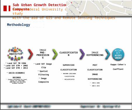
Methodology
Igbiloba O. Enoch (URP/08/4352) Supervisor: Dr. Oyinloye M.A.
DATA AQUISITION
• Land SAT TM 1986• Land SAT ETM + 2002• Land SAT ETM + 2013
• SOCIO-ECONOMIC RECORDS• Student Enrolments by Level, Gender for
1987/1988, 2002/2003 and 2012/2013 Academic Records
IMAGE PRE-PROCESSING
• Land SAT Image Clip
• Spatial Filtering
• Image Composite
CLASSIFICATION
SUPERVISED
CLASSIFICATION
• MAXIMUM LIKELIHOOD CLASSIFICATION
• RECLASSFICATIO
IMAGE DIFFERENCING
POST CLASSFICATION
IMAGE DIFFERENCING
• 1986 & 2002
• 2002 & 2013
ACCURACY
ASSESSMENT
Kappa Cohen’s
Coeffient
Sub Urban Growth Detection Around University CampusesUsing Federal University of Technology, Akure as a case study with the aid of GIS and Remote Sensing Techniques
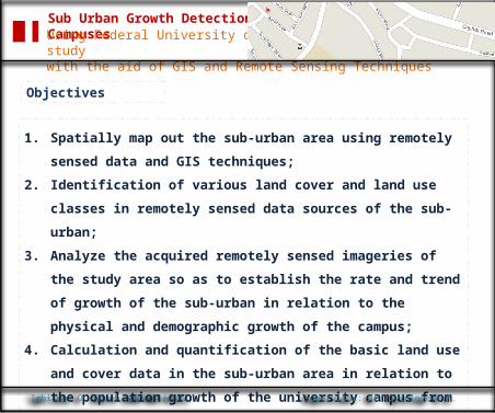
Objectives
Igbiloba O. Enoch (URP/08/4352)
1. Spatially map out the sub-urban area using remotely sensed data and GIS
techniques;
2. Identification of various land cover and land use classes in remotely sensed
data sources of the sub-urban;
3. Analyze the acquired remotely sensed imageries of the study area so as to
establish the rate and trend of growth of the sub-urban in relation to the
physical and demographic growth of the campus;
4. Calculation and quantification of the basic land use and cover data in the
sub-urban area in relation to the population growth of the university
campus from 1986, 2002 and to 2013;
Supervisor: Dr. Oyinloye M.A.
Sub Urban Growth Detection Around University CampusesUsing Federal University of Technology, Akure as a case study with the aid of GIS and Remote Sensing Techniques
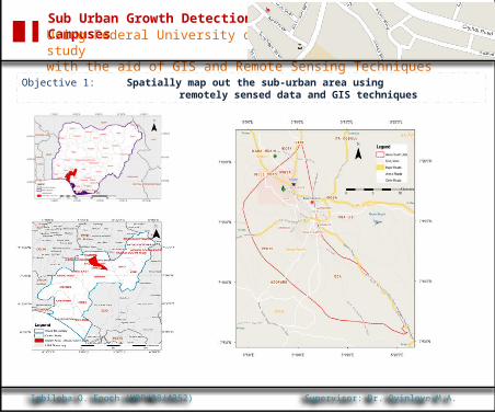
Objective 1: Spatially map out the sub-urban area using remotely sensed data
and GIS techniques
Igbiloba O. Enoch (URP/08/4352) Supervisor: Dr. Oyinloye M.A.
Sub Urban Growth Detection Around University CampusesUsing Federal University of Technology, Akure as a case study with the aid of GIS and Remote Sensing Techniques
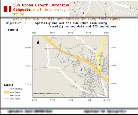
Objective 1: Spatially map out the sub-urban area using remotely sensed data
and GIS techniques (cont’d)
Igbiloba O. Enoch (URP/08/4352) Supervisor: Dr. Oyinloye M.A.
Sub Urban Growth Detection Around University CampusesUsing Federal University of Technology, Akure as a case study with the aid of GIS and Remote Sensing Techniques
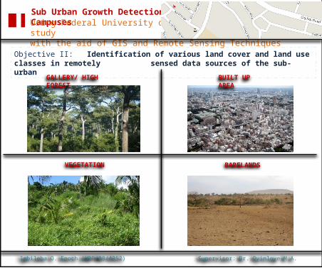
Objective II: Identification of various land cover and land use classes in remotely sensed data sources of the sub-urban
Igbiloba O. Enoch (URP/08/4352) Supervisor: Dr. Oyinloye M.A.
GALLERY/ HIGH FOREST
BUILT UP AREA
VEGETATION BARELANDS
Sub Urban Growth Detection Around University CampusesUsing Federal University of Technology, Akure as a case study with the aid of GIS and Remote Sensing Techniques
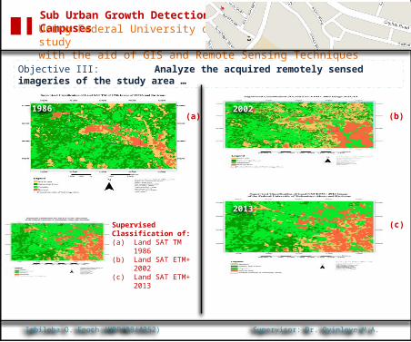
Objective III: Analyze the acquired remotely sensed imageries of the study area …
Igbiloba O. Enoch (URP/08/4352) Supervisor: Dr. Oyinloye M.A.
(a) (b)
(c)Supervised Classification of:(a) Land SAT TM
1986(b) Land SAT
ETM+ 2002(c) Land SAT
ETM+ 2013
1986 2002
2013
Sub Urban Growth Detection Around University CampusesUsing Federal University of Technology, Akure as a case study with the aid of GIS and Remote Sensing Techniques
Objective III: Analyze the acquired remotely sensed imageries of the study area … (cont’d)
Igbiloba O. Enoch (URP/08/4352) Supervisor: Dr. Oyinloye M.A.
Built Up Area
Gallery /High Forest
Vegetation
Bareland
-25 -20 -15 -10 -5 0 5 10 15
11
-21
3
7
Percentage
Built Up Area
Gallery /High Forest
Vegetation
Bareland
-10 -5 0 5 10 15
9
-7
1
-3
Percentage
1986-2002 2002-2013
Sub Urban Growth Detection Around University CampusesUsing Federal University of Technology, Akure as a case study with the aid of GIS and Remote Sensing Techniques
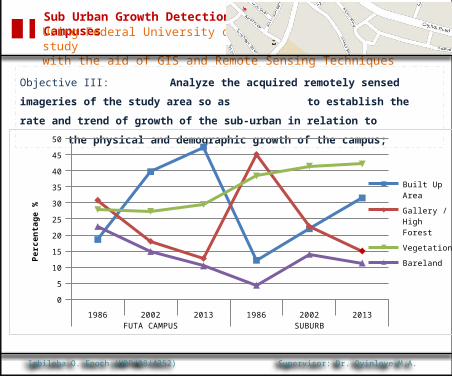
Objective III: Analyze the acquired remotely sensed imageries of the study area so as
to establish the rate and trend of growth of the
sub-urban in relation to the physical and
demographic growth of the campus;
Igbiloba O. Enoch (URP/08/4352) Supervisor: Dr. Oyinloye M.A.
1986 2002 2013 1986 2002 2013FUTA CAMPUS SUBURB
0
5
10
15
20
25
30
35
40
45
50
Built Up Area
Gallery /High Forest
Vegetation
BarelandPerc
enta
ge %
Sub Urban Growth Detection Around University CampusesUsing Federal University of Technology, Akure as a case study with the aid of GIS and Remote Sensing Techniques
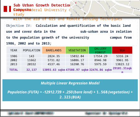
Objective IV: Calculation and quantification of the basic land use and cover data in the
sub-urban area in relation to the population
growth of the university campus from 1986, 2002 and
to 2013;
Igbiloba O. Enoch (URP/08/4352) Supervisor: Dr. Oyinloye M.A.
Multiple Linear Regression Model
Population (FUTA) = -12912.739 + .250 (bare land) + 1.568 (vegetation) + 2.323 (BUA)
YEAR POPULATION BARELANDS VEGETATION GALLERY FOREST BUA
1986 143 2824.35 15032.04 17554.29 5316.242002 11662 5731.82 16086.17 8946.98 9961.952013 20332 4537.46 16390.76 5975.59 13823.12
TOTAL 32,137 13093.63 sqkm 47508.97 sqkm 32476.86 sqkm 29101.31sqkm
Sub Urban Growth Detection Around University CampusesUsing Federal University of Technology, Akure as a case study with the aid of GIS and Remote Sensing Techniques
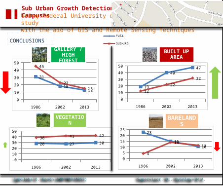
CONCLUSIONS
Igbiloba O. Enoch (URP/08/4352) Supervisor: Dr. Oyinloye M.A.
1986 2002 2013
0
10
20
30
40
50
19
4047
12
22
32
1986 2002 2013
0
10
20
30
40
50
31
1813
45
2315
1986 2002 2013
01020304050
28 27 3038 41 42
1986 2002 2013
0
5
10
15
2025
23
1510
4
1411
GALLERY / HIGH FOREST
BUILT UP AREA
VEGETATION BARELANDS
Sub Urban Growth Detection Around University CampusesUsing Federal University of Technology, Akure as a case study with the aid of GIS and Remote Sensing Techniques
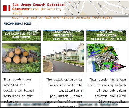
RECOMMENDATIONS
Igbiloba O. Enoch (URP/08/4352) Supervisor: Dr. Oyinloye M.A.
This study have revealed the
decline in forest resources
in the suburban,
The built up area is increasing
with the institution’s
population , hence demand for
off campus accommodation
This study has shown the
increasing growth of the sub-
urban towards the Akure City
metropolis
SUSTAINABLE RESIDENTIAL DEVELOPMENT
SUSTAINABLE FOREST MANAGEMENT
SPATIAL INFORMATION MANAGEMENT SYSTEM