Embed Size (px)
Citation preview
SUB-CORRIDORASSESSMENT-TEN-TRHINE-DANUBEINTERNATIONALWATERWAY
1|P a g e
Sub-corridorassessment:TEN-TRhine-DanubeInternationalWaterway(Serbia)Keyfindings:• Basedontheopinionsof18expertsfromsixcategories1keyknownandperceivedclimatethreatsto
asectionoftheTEN-TRhine-DanubeCorridorinSerbiaaredetermined.
• UsingClimaCorIIpre-scanmethodologysixmostimportantthreatsintermsoffutureriskaredetermined.Theseare:
o T24Damagetoenergysupply,trafficcommunicationnetworks,disruptiontooperationsduetoextremewind;
o T12Reducedclearanceunderbridgesduetoincreaseinaverageseasonalrainfall;
o T8Failureofflooddefencesystemsofriversandlakesduetolongperiodsofrain;
o T36Sedimentationinportchannels;inabilitytodockduetostormsurges;
o T31Damagetocranes,storageandloadingterminalstoextremewind;
o T5Fluvialfloodingduetoheavyshowers.
• Duringtheworkshopresultswerevalidatedandonemorethreatwasadded(whichwasjudgedbyexpertsasthemostimportantbutwasnotcoveredbyClimaCorIIlist).Thisis:
o T*-Lowerriverflowsduetoclimatechangeconditions(highertemperatures,floodsandchangesinprecipitationintensityanddistribution).
• Allsevenabovementionedthreatsaremappedalongthesub-corridor.
• Foreachthreatexpertsproposedadaptationmeasures.1.TransportinfrastructureThissectionpresentskeycharacteristics,e.g.topography,usability,i.e.(in)capacitytohandledemand,statei.e.poor/goodquality,safetyconcerns/vulnerabilities,foreseeninvestmentsetc,fortheSub-corridorTEN-TRhine-DanubeInternationalWaterway(sectionsoftheSavaRiverandtheDanubeRiverinSerbia,Figure1).2
1insixcategories,transportinfrastructurepractitioners,transportdemandmanagementexperts,climatechangespecialists,seeAnnex1forfulllistofsurveyparticipant’s2Sources:NinaSiedl,JuhaSchweighofer(2014).GuidebookforEnhancingResilienceofEuropeanInlandWaterwayTransportinExtremeWeatherEvents.www.mowe-it.eu/wordpress/wp-content/uploads/2013/02/Move_it_Guidebook_IWT.pdf(October2016)InternationalSavaRiverBasinCommission-ISRBCdocuments:SavaRiverBasinAnalysisSummary(2010);AnnualReportonWorkandActivities(2016);Water&ClimateAdaptationPlanfortheSavaRiverBasin(2015).www.savacommission.org(October2016)InternationalCommissionfortheProtectionoftheDanubeRiver–ICDPR,StrategyonAdaptationtoClimateChange(2013)http://www.icpdr.org/main/activities-projects/climate-change-adaptation(October2016)SEETO-Multi-AnnualDevelopmentPlan,Commonproblems–Sharedsolutions(2016).www.seetoint.org/wp-content/uploads/downloads/2016/01/SEETO_brosura_lowres.pdf(October2016)DanubeRiver,Navigationalchart(2016).Secondedition.DirectorateforInlandWaterways-Plovput.www.plovput.rs/file/plovidbene-karte/2016_03_RS_danube_paper_chart.zip(October2016)
SUB-CORRIDORASSESSMENT-TEN-TRHINE-DANUBEINTERNATIONALWATERWAY
2|P a g e
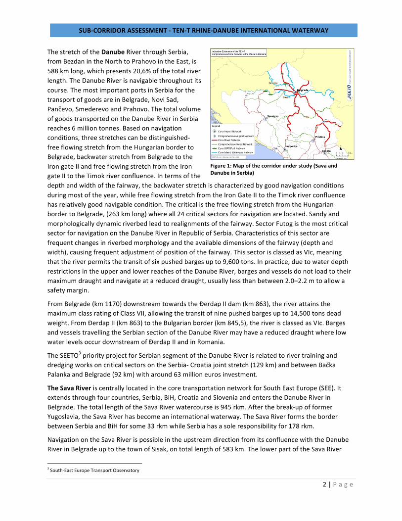
ThestretchoftheDanubeRiverthroughSerbia,fromBezdanintheNorthtoPrahovointheEast,is588kmlong,whichpresents20,6%ofthetotalriverlength.TheDanubeRiverisnavigablethroughoutitscourse.ThemostimportantportsinSerbiaforthetransportofgoodsareinBelgrade,NoviSad,Pančevo,SmederevoandPrahovo.ThetotalvolumeofgoodstransportedontheDanubeRiverinSerbiareaches6milliontonnes.Basedonnavigationconditions,threestretchescanbedistinguished-freeflowingstretchfromtheHungarianbordertoBelgrade,backwaterstretchfromBelgradetotheIrongateIIandfreeflowingstretchfromtheIrongateIItotheTimokriverconfluence.Intermsofthedepthandwidthofthefairway,thebackwaterstretchischaracterizedbygoodnavigationconditionsduringmostoftheyear,whilefreeflowingstretchfromtheIronGateIItotheTimokriverconfluencehasrelativelygoodnavigablecondition.ThecriticalisthefreeflowingstretchfromtheHungarianbordertoBelgrade,(263kmlong)whereall24criticalsectorsfornavigationarelocated.Sandyandmorphologicallydynamicriverbedleadtorealignmentsofthefairway.SectorFutogisthemostcriticalsectorfornavigationontheDanubeRiverinRepublicofSerbia.Characteristicsofthissectorarefrequentchangesinriverbedmorphologyandtheavailabledimensionsofthefairway(depthandwidth),causingfrequentadjustmentofpositionofthefairway.ThissectorisclassedasVIc,meaningthattheriverpermitsthetransitofsixpushedbargesupto9,600tons.Inpractice,duetowaterdepthrestrictionsintheupperandlowerreachesoftheDanubeRiver,bargesandvesselsdonotloadtotheirmaximumdraughtandnavigateatareduceddraught,usuallylessthanbetween2.0–2.2mtoallowasafetymargin.
FromBelgrade(km1170)downstreamtowardstheĐerdapIIdam(km863),theriverattainsthemaximumclassratingofClassVII,allowingthetransitofninepushedbargesupto14,500tonsdeadweight.FromĐerdapII(km863)totheBulgarianborder(km845,5),theriverisclassedasVIc.BargesandvesselstravellingtheSerbiansectionoftheDanubeRivermayhaveareduceddraughtwherelowwaterlevelsoccurdownstreamofĐerdapIIandinRomania.
TheSEETO3priorityprojectforSerbiansegmentoftheDanubeRiverisrelatedtorivertraininganddredgingworksoncriticalsectorsontheSerbia-Croatiajointstretch(129km)andbetweenBačkaPalankaandBelgrade(92km)witharound63millioneurosinvestment.
TheSavaRiveriscentrallylocatedinthecoretransportationnetworkforSouthEastEurope(SEE).Itextendsthroughfourcountries,Serbia,BiH,CroatiaandSloveniaandenterstheDanubeRiverinBelgrade.ThetotallengthoftheSavaRiverwatercourseis945rkm.Afterthebreak-upofformerYugoslavia,theSavaRiverhasbecomeaninternationalwaterway.TheSavaRiverformstheborderbetweenSerbiaandBiHforsome33rkmwhileSerbiahasasoleresponsibilityfor178rkm.
NavigationontheSavaRiverispossibleintheupstreamdirectionfromitsconfluencewiththeDanubeRiverinBelgradeuptothetownofSisak,ontotallengthof583km.ThelowerpartoftheSavaRiver
3South-EastEuropeTransportObservatory
Figure1:Mapofthecorridorunderstudy(SavaandDanubeinSerbia)
SUB-CORRIDORASSESSMENT-TEN-TRHINE-DANUBEINTERNATIONALWATERWAY
3|P a g e
watercoursewhichrunsthroughSerbiaischaracterizedbyflatplains,low-lyingagricultureregion.Thewarandthepoliticalcrisisinearly1990snegativelyaffectedthemaintenanceandinvestmentsintotheriverandtheportsinfrastructureandledtoahugedeclineofeconomicactivities.ThecargohandledintheSerbianportsontheSavaRiverinrecentyearswasdowntolessthan25thousandtons.Theannualtrafficvolumeshavedroppedfromover5milliontonspriortopoliticalchangestolessthan400.000tonsontheentirewaterway.
ThecurrentstateoftheSavawaterwayispoor.Thenavigationconditionsarehamperedbybothnaturalconditionsandlackofmaintenanceandinvestments.Themainproblemsarisefrom:shallowdepthofthenavigationchannelwhichlimitsdraftoverlongperiodoftime;sharpcurvesduetomeanderslimitingthelengthandwidthofvesselsandconvoys;strongfluctuationdischargeresultinginstrongvariationinwaterlevelsanddepthsduringtheyear;heavysedimentationandareductioninthewidthanddepthofthefairwayincertainareas;limitedheightunderbridgesathighwater.CriticalsectorsfornavigationontheSavaRiverintheRepublicofSerbiaareKamičak,Šabac,Klenak,SremskaMitrovicaandfirthoftheDrinaRiver.Intermsofavailabledepthandwidthoffairway,firthoftheDrinaRiveristhemostcriticalone.TheactualclassificationoftheSavaRiverfromBelgradetoSisakis50/50classIIIandclassIV.ThesituationinthefieldisfarfrommeetingtherequirementsforClassIVandVawaterwaysontheentirelengthofthefairway.
TheripariancountriesandISRBC4aimsatrehabilitationanddevelopmentofthewaterway,improvingtheSavaRiverbetweenBelgradeandSisaktominimumClassIVwaterwayandtoClassVaonsectorswhereitispossibleandfeasible.
TheSEETOpriorityprojectforSerbiansegmentoftheSavaRiverisrelatedtorivertraininganddredgingworksoncriticalsectors(9millionEurosestimatedcostsfor211kmlongstretch).RepublicofSerbiastartedwiththeactivitiestosecurefinancingforthedevelopmentoftheSavaRiverprojectontheSerbiansectorfromtheavailableIPAfunds.
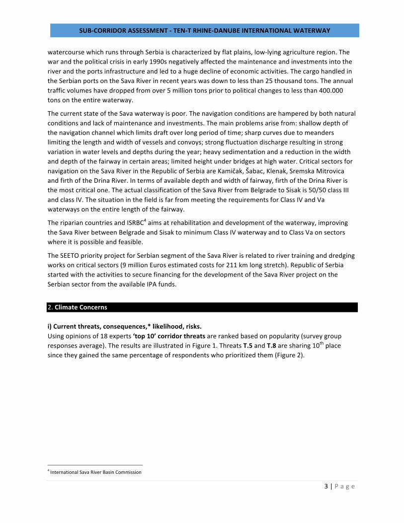
2.ClimateConcernsi)Currentthreats,consequences,*likelihood,risks.Usingopinionsof18experts‘top10’corridorthreatsarerankedbasedonpopularity(surveygroupresponsesaverage).TheresultsareillustratedinFigure1.ThreatsT.5andT.8aresharing10thplacesincetheygainedthesamepercentageofrespondentswhoprioritizedthem(Figure2).
4InternationalSavaRiverBasinCommission
SUB-CORRIDORASSESSMENT-TEN-TRHINE-DANUBEINTERNATIONALWATERWAY
4|P a g e
Figure2:RankingofTopThreatsAccordingtoPopularity
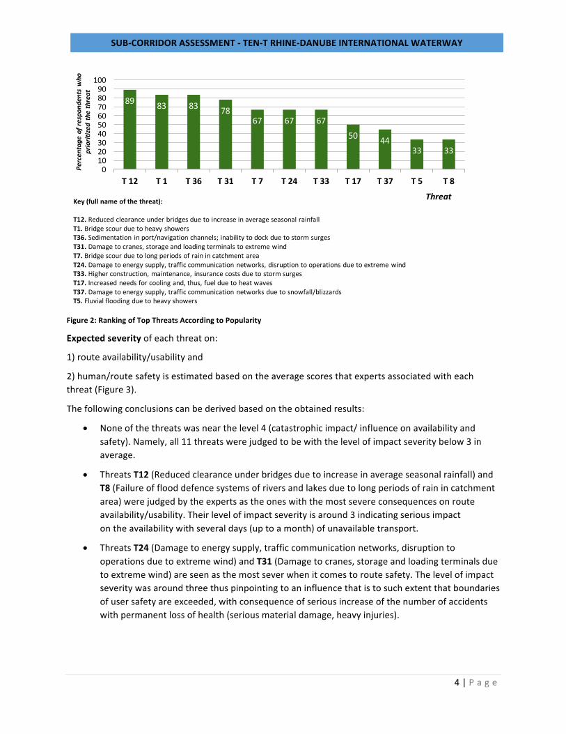
Expectedseverityofeachthreaton:
1)routeavailability/usabilityand
2)human/routesafetyisestimatedbasedontheaveragescoresthatexpertsassociatedwitheachthreat(Figure3).
Thefollowingconclusionscanbederivedbasedontheobtainedresults:
• Noneofthethreatswasnearthelevel4(catastrophicimpact/influenceonavailabilityandsafety).Namely,all11threatswerejudgedtobewiththelevelofimpactseveritybelow3inaverage.
• ThreatsT12(Reducedclearanceunderbridgesduetoincreaseinaverageseasonalrainfall)andT8(Failureofflooddefencesystemsofriversandlakesduetolongperiodsofrainincatchmentarea)werejudgedbytheexpertsastheoneswiththemostsevereconsequencesonrouteavailability/usability.Theirlevelofimpactseverityisaround3indicatingseriousimpactontheavailabilitywithseveraldays(uptoamonth)ofunavailabletransport.
• ThreatsT24(Damagetoenergysupply,trafficcommunicationnetworks,disruptiontooperationsduetoextremewind)andT31(Damagetocranes,storageandloadingterminalsduetoextremewind)areseenasthemostseverwhenitcomestoroutesafety.Thelevelofimpactseveritywasaroundthreethuspinpointingtoaninfluencethatistosuchextentthatboundariesofusersafetyareexceeded,withconsequenceofseriousincreaseofthenumberofaccidentswithpermanentlossofhealth(seriousmaterialdamage,heavyinjuries).
89 83 83 7867 67 67
50 4433 33
0102030405060708090
100
T12 T1 T36 T31 T7 T24 T33 T17 T37 T5 T8
Percentageofrespo
ndentsw
ho
prioritize
dthethreat
ThreatKey (full name of the threat):
T12. Reduced clearance under bridges due to increase in average seasonal rainfallT1. Bridge scour due to heavy showersT36. Sedimentation in port/navigation channels; inability to dock due to storm surgesT31. Damage to cranes, storage and loading terminals to extreme windT7. Bridge scour due to long periods of rain in catchment areaT24. Damage to energy supply, traffic communication networks, disruption to operations due to extreme windT33. Higher construction, maintenance, insurance costs due to storm surgesT17. Increased needs for cooling and, thus, fuel due to heat wavesT37. Damage to energy supply, traffic communication networks due to snowfall/blizzardsT5. Fluvial flooding due to heavy showers
SUB-CORRIDORASSESSMENT-TEN-TRHINE-DANUBEINTERNATIONALWATERWAY
5|P a g e
Figure3:Levelofimpactseverityfor11“Top”threats
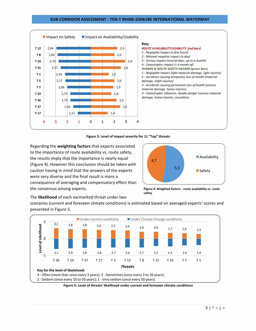
Regardingtheweightingfactorsthatexpertsassociatedtotheimportanceofrouteavailabilityvs.routesafety,theresultsimplythattheimportanceisnearlyequal(Figure4).Howeverthisconclusionshouldbetakenwithcautionhavinginmindthattheanswersoftheexpertswereverydiverseandthefinalresultismoreaconsequenceofaveragingandcompensatoryeffectthantheconsensusamongexperts.
Thelikelihoodofeachearmarkedthreatundertwoscenarios(currentandforeseenclimateconditions)isestimatedbasedonaveragedexperts'scoresandpresentedinFigure5.
Figure5:Levelofthreats'likelihoodundercurrentandforeseenclimateconditions
1,11
1,50
1,73
1,75
2,00
2,17
2,20
2,57
2,75
2,83
2,94
1,4
2,5
2,2
1,8
1,9
2,0
1,5
2,6
2,9
2,0
2,3
4 3 2 1 0 1 2 3 4
T17
T37
T36
T33
T7
T5
T1
T31
T24
T8
T12
ImpactonSafety ImpactonAvailability/UsabilityKey:ROUTEAVAILABILITY/USABILITY (redbars)1- Negligibleimpact(afewhours)2- Minimalnegativeimpact(aday)3- Seriousimpact(severaldays,uptoamonth)4- Catastrophicimpact(>amonthof)HUMAN&ROUTESAFETYHAZARD(greenbars)1- Negligibleimpact(lightmaterialdamage,lightinjuries)2- Accidentscausingtemporarylossofhealth(materialdamage,slightinjuries)3- Accidentscausingpermanentlossofhealth(seriousmaterialdamage,heavyinjuries)4- Catastrophicinfluence,deadlydanger(seriousmaterialdamage,heavyinjuries,casualties)
3,1 2,8 2,8 2,6 2,5 2,4 2,0 2,0 1,7 1,6 1,3
5
0
5
T36 T24 T37 T17 T5 T12 T8 T31 T33 T7 T1
LevelofLikelihoo
d
ThreatsKeyfortheleveloflikelehood:4- Often(morethanonceevery3years); 3- Sometimes(onceevery3to10years);2- Seldom(onceevery10to50years);1- Veryseldom(onceevery50years)
Undercurrentconditions UnderClimateChangeconditions
3.1 2.92.82.82.72.62.72.22.32.01.9
5,3
4,7Availability
Safety
Figure4:Weightedfactors-routeavailabilityvs.routesafety
SUB-CORRIDORASSESSMENT-TEN-TRHINE-DANUBEINTERNATIONALWATERWAY
6|P a g e
Thefollowingconclusionscanbederived:
• Regardinglikelihoodofthethreatsunderclimatechangeconditions:
• Noneofthethreatsisexpectedtoappearmorethanonceevery3years(leveloflikelihood-4).
• ThreatsT36(Sedimentationinport/navigationchannels;inabilitytodockduetostormsurges)andT24(Damagetoenergysupply,trafficcommunicationnetworks,disruptiontooperationsduetoextremewind)areexpectedtobemostfrequentwithlevelof3(implyingthatconsequenceswillappearevery3to10years).
• RegardingtheincreaseoftheleveloflikelihoodthreatsT7(Bridgescourduetolongperiodsofrainincatchmentarea)andT33(Higherconstruction,maintenance,insurancecostsduetostormsurges)areexpectedtoappearmoreoftenduetoclimatechangeconditions(fromveryseldomtoseldom)forexample.
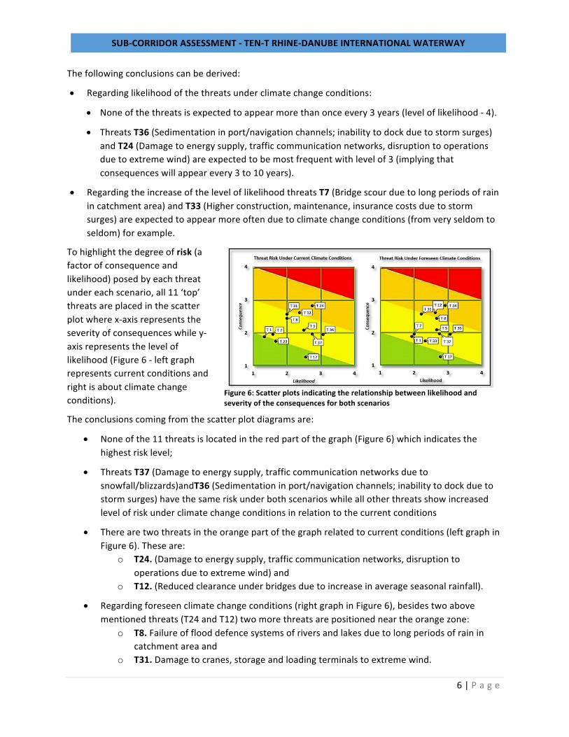
Tohighlightthedegreeofrisk(afactorofconsequenceandlikelihood)posedbyeachthreatundereachscenario,all11‘top’threatsareplacedinthescatterplotwherex-axisrepresentstheseverityofconsequenceswhiley-axisrepresentstheleveloflikelihood(Figure6-leftgraphrepresentscurrentconditionsandrightisaboutclimatechangeconditions).
Theconclusionscomingfromthescatterplotdiagramsare:
• Noneofthe11threatsislocatedintheredpartofthegraph(Figure6)whichindicatesthehighestrisklevel;
• ThreatsT37(Damagetoenergysupply,trafficcommunicationnetworksduetosnowfall/blizzards)andT36(Sedimentationinport/navigationchannels;inabilitytodockduetostormsurges)havethesameriskunderbothscenarioswhileallotherthreatsshowincreasedlevelofriskunderclimatechangeconditionsinrelationtothecurrentconditions
• Therearetwothreatsintheorangepartofthegraphrelatedtocurrentconditions(leftgraphinFigure6).Theseare:
o T24.(Damagetoenergysupply,trafficcommunicationnetworks,disruptiontooperationsduetoextremewind)and
o T12.(Reducedclearanceunderbridgesduetoincreaseinaverageseasonalrainfall).
• Regardingforeseenclimatechangeconditions(rightgraphinFigure6),besidestwoabovementionedthreats(T24andT12)twomorethreatsarepositionedneartheorangezone:
o T8.Failureofflooddefencesystemsofriversandlakesduetolongperiodsofrainincatchmentareaand
o T31.Damagetocranes,storageandloadingterminalstoextremewind.
Figure6:Scatterplotsindicatingtherelationshipbetweenlikelihoodandseverityoftheconsequencesforbothscenarios
SUB-CORRIDORASSESSMENT-TEN-TRHINE-DANUBEINTERNATIONALWATERWAY
7|P a g e
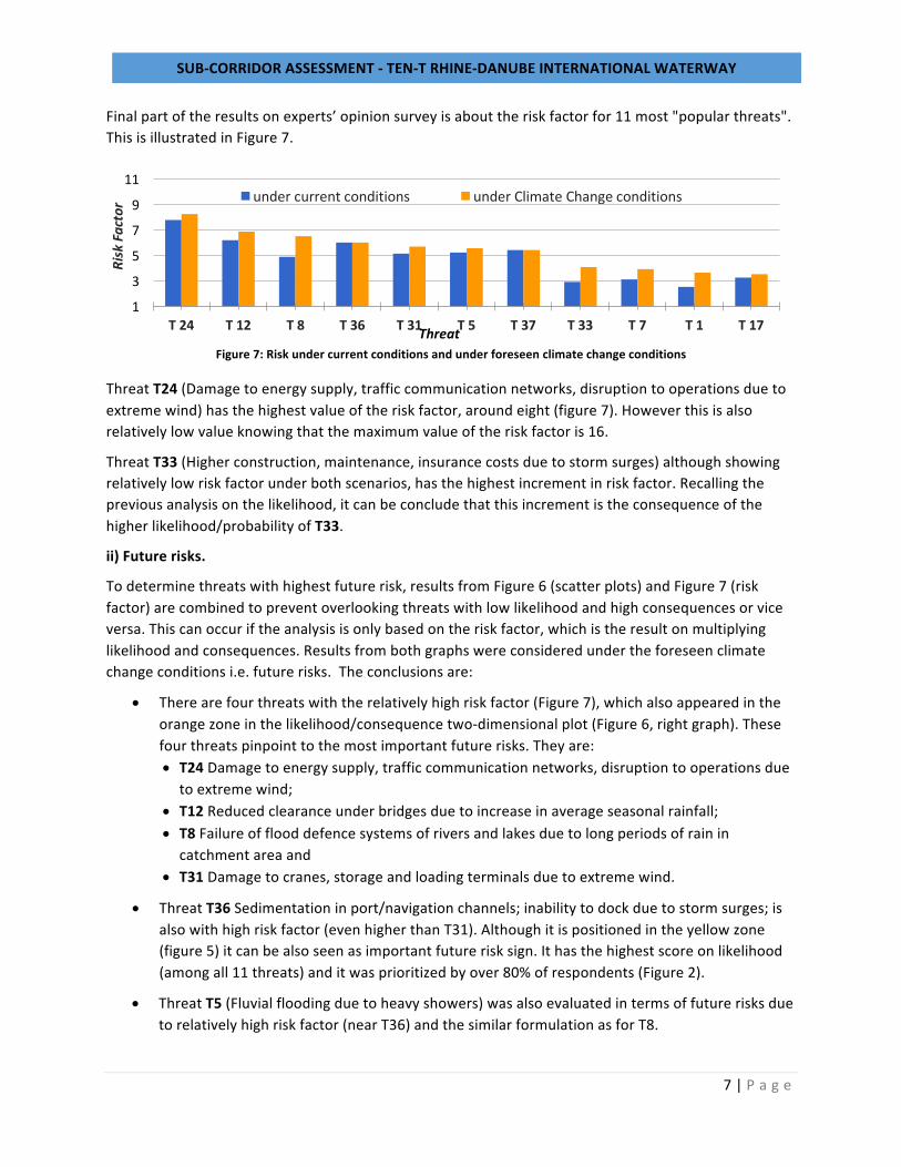
Finalpartoftheresultsonexperts’opinionsurveyisabouttheriskfactorfor11most"popularthreats".ThisisillustratedinFigure7.
Figure7:Riskundercurrentconditionsandunderforeseenclimatechangeconditions
ThreatT24(Damagetoenergysupply,trafficcommunicationnetworks,disruptiontooperationsduetoextremewind)hasthehighestvalueoftheriskfactor,aroundeight(figure7).Howeverthisisalsorelativelylowvalueknowingthatthemaximumvalueoftheriskfactoris16.
ThreatT33(Higherconstruction,maintenance,insurancecostsduetostormsurges)althoughshowingrelativelylowriskfactorunderbothscenarios,hasthehighestincrementinriskfactor.Recallingthepreviousanalysisonthelikelihood,itcanbeconcludethatthisincrementistheconsequenceofthehigherlikelihood/probabilityofT33.
ii)Futurerisks.
Todeterminethreatswithhighestfuturerisk,resultsfromFigure6(scatterplots)andFigure7(riskfactor)arecombinedtopreventoverlookingthreatswithlowlikelihoodandhighconsequencesorviceversa.Thiscanoccuriftheanalysisisonlybasedontheriskfactor,whichistheresultonmultiplyinglikelihoodandconsequences.Resultsfrombothgraphswereconsideredundertheforeseenclimatechangeconditionsi.e.futurerisks.Theconclusionsare:
• Therearefourthreatswiththerelativelyhighriskfactor(Figure7),whichalsoappearedintheorangezoneinthelikelihood/consequencetwo-dimensionalplot(Figure6,rightgraph).Thesefourthreatspinpointtothemostimportantfuturerisks.Theyare:• T24Damagetoenergysupply,trafficcommunicationnetworks,disruptiontooperationsdue
toextremewind;• T12Reducedclearanceunderbridgesduetoincreaseinaverageseasonalrainfall;• T8Failureofflooddefencesystemsofriversandlakesduetolongperiodsofrainin
catchmentareaand• T31Damagetocranes,storageandloadingterminalsduetoextremewind.
• ThreatT36Sedimentationinport/navigationchannels;inabilitytodockduetostormsurges;isalsowithhighriskfactor(evenhigherthanT31).Althoughitispositionedintheyellowzone(figure5)itcanbealsoseenasimportantfuturerisksign.Ithasthehighestscoreonlikelihood(amongall11threats)anditwasprioritizedbyover80%ofrespondents(Figure2).
• ThreatT5(Fluvialfloodingduetoheavyshowers)wasalsoevaluatedintermsoffuturerisksduetorelativelyhighriskfactor(nearT36)andthesimilarformulationasforT8.
1
3
5
7
9
11
T24 T12 T8 T36 T31 T5 T37 T33 T7 T1 T17
RiskFa
ctor
Threat
undercurrentconditions underClimateChangeconditions
SUB-CORRIDORASSESSMENT-TEN-TRHINE-DANUBEINTERNATIONALWATERWAY
8|P a g e
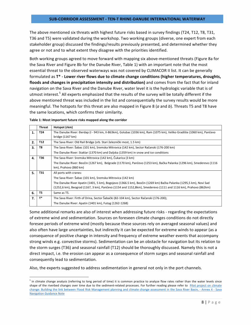
Theabovementionedsixthreatswithhighestfuturerisksbasedinsurveyfindings(T24,T12,T8,T31,T36andT5)werevalidatedduringtheworkshop.Twoworkinggroups(diverse,oneexpertfromeachstakeholdergroup)discussedthefindings/resultspreviouslypresented,anddeterminedwhethertheyagreeornotandtowhatextenttheydisagreewiththeprioritiesidentified.
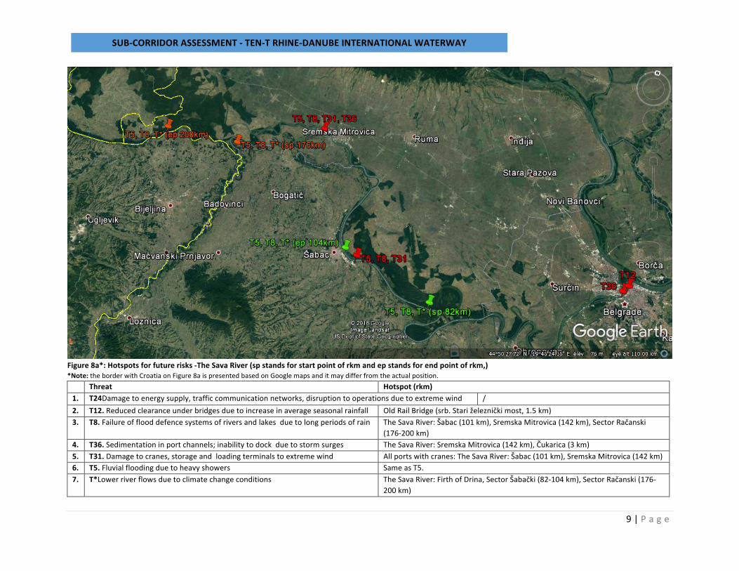
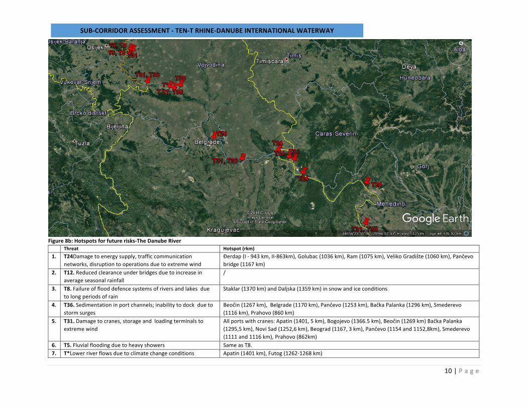
Bothworkinggroupsagreedtomoveforwardwithmappingsixabove-mentionedthreats(Figure8afortheSavaRiverandFigure8bfortheDanubeRiver,Table1)withanimportantnotethatthemostessentialthreattotheobservedwaterwayswasnotcoveredbyCLIMACORIIlist.ItcanbegenerallyformulatedasT*-Lowerriverflowsduetoclimatechangeconditions(highertemperatures,droughts,floodsandchangesinprecipitationintensityanddistribution)andcomesfromthefactthatforinlandnavigationontheSavaRiverandtheDanubeRiver,waterlevelitisthehydrologicvariablethatisofutmostinterest.5Allexpertsemphasizedthattheresultsofthesurveywillbetotallydifferentiftheabovementionedthreatwasincludedinthelistandconsequentiallythesurveyresultswouldbemoremeaningful.ThehotspotsforthisthreatarealsomappedinFigure8(aandb).ThreatsT5andT8havethesamelocations,whichconfirmstheirsimilarity.
Table1:Mostimportantfuturerisksmappedalongthecorridor
Threat Hotspot(rkm)
1. T24 TheDanubeRiver:Đerdap(I-943km,II-863km),Golubac(1036km),Ram(1075km),VelikoGradište(1060km),Pančevobridge(1167km)
2. T12 TheSavaRiver:OldRailBridge(srb.Stariželezničkimost,1.5km)
3. T8 TheSavaRiver:Šabac(101km),SremskaMitrovica(142km),SectorRačanski(176-200km)TheDanubeRiver:Staklar(1370km)andDaljska(1359km)insnowandiceconditions
4. T36 TheSavaRiver:SremskaMitrovica(142km),Čukarica(3km)TheDanubeRiver:Beočin(1267km),Belgrade(1170km),Pančevo(1253km),BačkaPalanka(1296km),Smederevo(1116km),Prahovo(860km)
5. T31 Allportswithcranes:TheSavaRiver:Šabac(101km),SremskaMitrovica(142km)TheDanubeRiverApatin(1401,5km),Bogojevo(1366.5km),Beočin(1269km)BačkaPalanka(1295,5km),NoviSad(1252,6km),Beograd(1167,3km),Pančevo(1154and1152,8km),Smederevo(1111and1116km),Prahovo(862km)
6. T5 SameasT5.
7. T* TheSavaRiver:FirthofDrina,SectorŠabački(82-104km),SectorRačanski(176-200);TheDanubeRiver:Apatin(1401km),Futog(1262-1268)
Someadditionalremarksarealsoofinterestwhenaddressingfuturerisks-regardingtheexpectationsofextremewindandsedimentation.Sourcesonforeseenclimatechangesconditionsdonotdirectlyforeseeperiodsofextremewind(mostlybecausethesesourcesrelyonaveragedseasonalvalues)andalsooftenhavelargeuncertainties,butindirectlyitcanbeexpectedforextremewindstoappear(asaconsequenceofpositivechangeinintensityandfrequencyofextremeweathereventsthataccompanystrongwindse.g.convectivestorms).Sedimentationcanbeanobstaclefornavigationbutitsrelationtothestormsurges(T36)andseasonalrainfall(T12)shouldbethoroughlydiscussed.Namelythisisnotadirectimpact,i.e.theerosioncanappearasaconsequenceofstormsurgesandseasonalrainfallandconsequentlyleadtosedimentation.
Also,theexpertssuggestedtoaddresssedimentationingeneralnotonlyintheportchannels.
5 inclimatechangeanalysis (referring to longperiodof time) it iscommonpractice toanalyze flowrates rather than thewater levels sinceshapeoftheriverbedchangesovertimeduetothesediment-relatedprocesses.Forfurtherreadingpleasereferto Pilotprojectonclimatechange:BuildingthelinkbetweenFloodRiskManagementplanningandclimatechangeassessmentintheSavaRiverBasin,-Annex4-SavaNavigationGuidanceNote
SUB-CORRIDORASSESSMENT-TEN-TRHINE-DANUBEINTERNATIONALWATERWAY
9|P a g e
Figure8a*:Hotspotsforfuturerisks-TheSavaRiver(spstandsforstartpointofrkmandepstandsforendpointofrkm,)*Note:theborderwithCroatiaonFigure8aispresentedbasedonGooglemapsanditmaydifferfromtheactualposition. Threat Hotspot(rkm)1. T24Damagetoenergysupply,trafficcommunicationnetworks,disruptiontooperationsduetoextremewind /2. T12.Reducedclearanceunderbridgesduetoincreaseinaverageseasonalrainfall OldRailBridge(srb.Stariželezničkimost,1.5km)3. T8.Failureofflooddefencesystemsofriversandlakesduetolongperiodsofrain TheSavaRiver:Šabac(101km),SremskaMitrovica(142km),SectorRačanski
(176-200km)4. T36.Sedimentationinportchannels;inabilitytodockduetostormsurges TheSavaRiver:SremskaMitrovica(142km),Čukarica(3km)5. T31.Damagetocranes,storageandloadingterminalstoextremewind Allportswithcranes:TheSavaRiver:Šabac(101km),SremskaMitrovica(142km)6. T5.Fluvialfloodingduetoheavyshowers SameasT5.7. T*Lowerriverflowsduetoclimatechangeconditions TheSavaRiver:FirthofDrina,SectorŠabački(82-104km),SectorRačanski(176-
200km)
SUB-CORRIDORASSESSMENT-TEN-TRHINE-DANUBEINTERNATIONALWATERWAY
10|P a g e
Figure8b:Hotspotsforfuturerisks-TheDanubeRiver Threat Hotspot(rkm)1. T24Damagetoenergysupply,trafficcommunication
networks,disruptiontooperationsduetoextremewindĐerdap(I-943km,II-863km),Golubac(1036km),Ram(1075km),VelikoGradište(1060km),Pančevobridge(1167km)
2. T12.Reducedclearanceunderbridgesduetoincreaseinaverageseasonalrainfall
/
3. T8.Failureofflooddefencesystemsofriversandlakesduetolongperiodsofrain
Staklar(1370km)andDaljska(1359km)insnowandiceconditions
4. T36.Sedimentationinportchannels;inabilitytodockduetostormsurges
Beočin(1267km),Belgrade(1170km),Pančevo(1253km),BačkaPalanka(1296km),Smederevo(1116km),Prahovo(860km)
5. T31.Damagetocranes,storageandloadingterminalstoextremewind
Allportswithcranes:Apatin(1401,5km),Bogojevo(1366.5km),Beočin(1269km)BačkaPalanka(1295,5km),NoviSad(1252,6km),Beograd(1167,3km),Pančevo(1154and1152,8km),Smederevo(1111and1116km),Prahovo(862km)
6. T5.Fluvialfloodingduetoheavyshowers SameasT8.7. T*Lowerriverflowsduetoclimatechangeconditions Apatin(1401km),Futog(1262-1268km)
SUB-CORRIDORASSESSMENT-TEN-TRHINE-DANUBEINTERNATIONALWATERWAY
11|P a g e
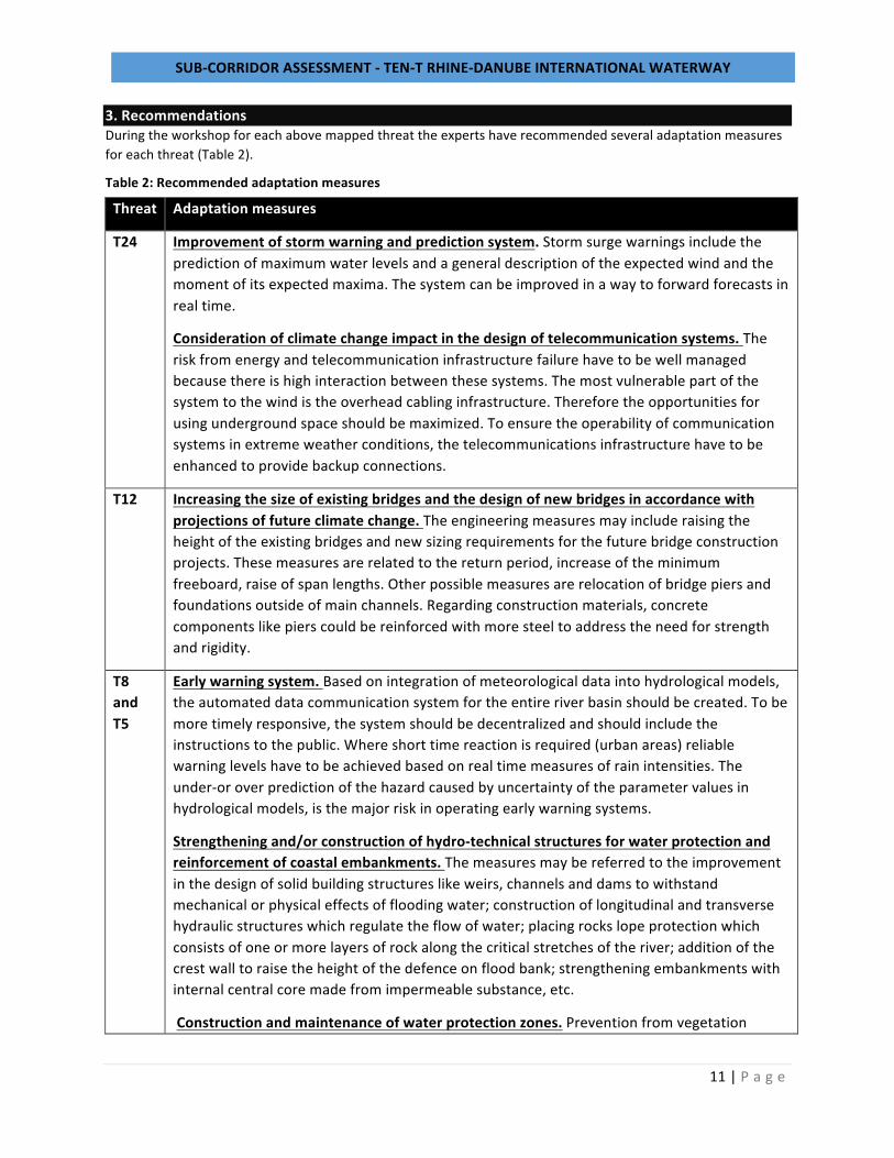
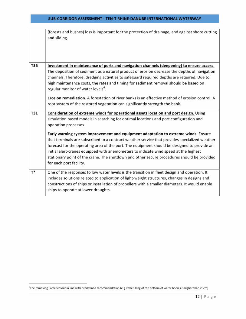
3.RecommendationsDuringtheworkshopforeachabovemappedthreattheexpertshaverecommendedseveraladaptationmeasuresforeachthreat(Table2).
Table2:Recommendedadaptationmeasures
Threat Adaptationmeasures
T24 Improvementofstormwarningandpredictionsystem.Stormsurgewarningsincludethepredictionofmaximumwaterlevelsandageneraldescriptionoftheexpectedwindandthemomentofitsexpectedmaxima.Thesystemcanbeimprovedinawaytoforwardforecastsinrealtime.
Considerationofclimatechangeimpactinthedesignoftelecommunicationsystems.Theriskfromenergyandtelecommunicationinfrastructurefailurehavetobewellmanagedbecausethereishighinteractionbetweenthesesystems.Themostvulnerablepartofthesystemtothewindistheoverheadcablinginfrastructure.Thereforetheopportunitiesforusingundergroundspaceshouldbemaximized.Toensuretheoperabilityofcommunicationsystemsinextremeweatherconditions,thetelecommunicationsinfrastructurehavetobeenhancedtoprovidebackupconnections.
T12 Increasingthesizeofexistingbridgesandthedesignofnewbridgesinaccordancewithprojectionsoffutureclimatechange.Theengineeringmeasuresmayincluderaisingtheheightoftheexistingbridgesandnewsizingrequirementsforthefuturebridgeconstructionprojects.Thesemeasuresarerelatedtothereturnperiod,increaseoftheminimumfreeboard,raiseofspanlengths.Otherpossiblemeasuresarerelocationofbridgepiersandfoundationsoutsideofmainchannels.Regardingconstructionmaterials,concretecomponentslikepierscouldbereinforcedwithmoresteeltoaddresstheneedforstrengthandrigidity.
T8andT5
Earlywarningsystem.Basedonintegrationofmeteorologicaldataintohydrologicalmodels,theautomateddatacommunicationsystemfortheentireriverbasinshouldbecreated.Tobemoretimelyresponsive,thesystemshouldbedecentralizedandshouldincludetheinstructionstothepublic.Whereshorttimereactionisrequired(urbanareas)reliablewarninglevelshavetobeachievedbasedonrealtimemeasuresofrainintensities.Theunder-oroverpredictionofthehazardcausedbyuncertaintyoftheparametervaluesinhydrologicalmodels,isthemajorriskinoperatingearlywarningsystems.
Strengtheningand/orconstructionofhydro-technicalstructuresforwaterprotectionandreinforcementofcoastalembankments.Themeasuresmaybereferredtotheimprovementinthedesignofsolidbuildingstructureslikeweirs,channelsanddamstowithstandmechanicalorphysicaleffectsoffloodingwater;constructionoflongitudinalandtransversehydraulicstructureswhichregulatetheflowofwater;placingrockslopeprotectionwhichconsistsofoneormorelayersofrockalongthecriticalstretchesoftheriver;additionofthecrestwalltoraisetheheightofthedefenceonfloodbank;strengtheningembankmentswithinternalcentralcoremadefromimpermeablesubstance,etc.
Constructionandmaintenanceofwaterprotectionzones.Preventionfromvegetation
SUB-CORRIDORASSESSMENT-TEN-TRHINE-DANUBEINTERNATIONALWATERWAY
12|P a g e
(forestsandbushes)lossisimportantfortheprotectionofdrainage,andagainstshorecuttingandsliding.
T36 Investmentinmaintenanceofportsandnavigationchannels(deepening)toensureaccess.Thedepositionofsedimentasanaturalproductoferosiondecreasethedepthsofnavigationchannels.Therefore,dredgingactivitiestosafeguardrequireddepthsarerequired.Duetohighmaintenancecosts,theratesandtimingforsedimentremovalshouldbebasedonregularmonitorofwaterlevels6.
Erosionremediation.Aforestationofriverbanksisaneffectivemethodoferosioncontrol.Arootsystemoftherestoredvegetationcansignificantlystrengththebank.
T31 Considerationofextremewindsforoperationalassetslocationandportdesign.Usingsimulationbasedmodelsinsearchingforoptimallocationsandportconfigurationandoperationprocesses.
Earlywarningsystemimprovementandequipmentadaptationtoextremewinds.Ensurethatterminalsaresubscribedtoacontractweatherservicethatprovidesspecializedweatherforecastfortheoperatingareaoftheport.Theequipmentshouldbedesignedtoprovideaninitialalert-cranesequippedwithanemometerstoindicatewindspeedatthehigheststationarypointofthecrane.Theshutdownandothersecureproceduresshouldbeprovidedforeachportfacility.
T* Oneoftheresponsestolowwaterlevelsisthetransitioninfleetdesignandoperation.Itincludessolutionsrelatedtoapplicationoflight-weightstructures,changesindesignsandconstructionsofshipsorinstallationofpropellerswithasmallerdiameters.Itwouldenableshipstooperateatlowerdraughts.
6Theremovingiscarriedoutinlinewithpredefinedrecommendation(e.gifthefillingofthebottomofwaterbodiesishigherthan20cm)
SUB-CORRIDORASSESSMENT-TEN-TRHINE-DANUBEINTERNATIONALWATERWAY
13|P a g e
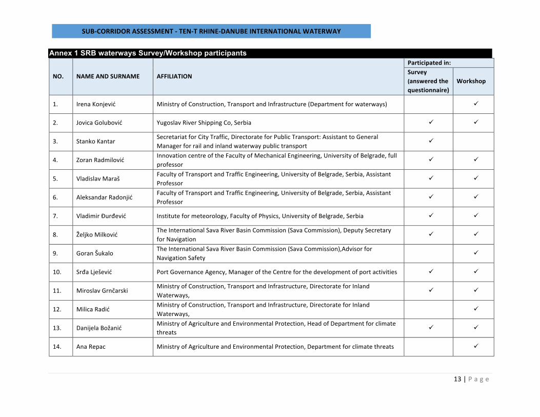
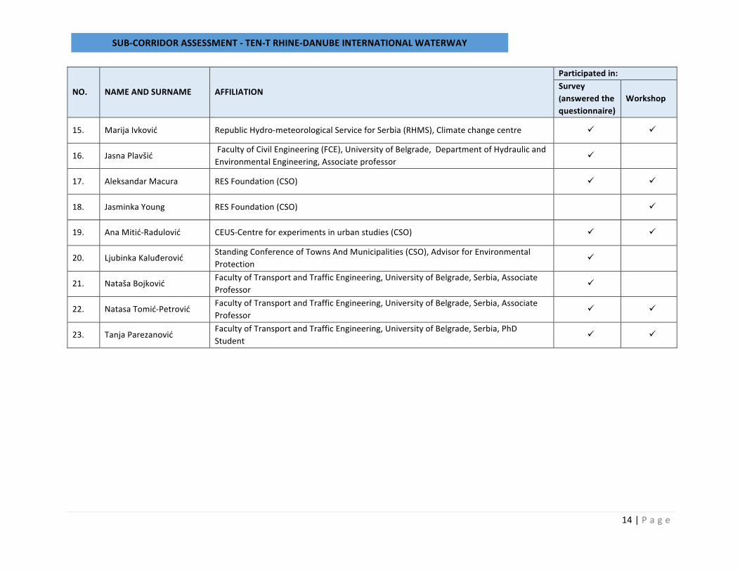
Annex 1 SRB waterways Survey/Workshop participants
NO. NAMEANDSURNAME AFFILIATION
Participatedin:Survey(answeredthequestionnaire)
Workshop
1. IrenaKonjević MinistryofConstruction,TransportandInfrastructure(Departmentforwaterways) ü
2. JovicaGolubović YugoslavRiverShippingCo,Serbia ü ü
3. StankoKantar SecretariatforCityTraffic,DirectorateforPublicTransport:AssistanttoGeneralManagerforrailandinlandwaterwaypublictransport
ü
4. ZoranRadmilović InnovationcentreoftheFacultyofMechanicalEngineering,UniversityofBelgrade,fullprofessor
ü ü
5. VladislavMaraš FacultyofTransportandTrafficEngineering,UniversityofBelgrade,Serbia,AssistantProfessor
ü ü
6. AleksandarRadonjić FacultyofTransportandTrafficEngineering,UniversityofBelgrade,Serbia,AssistantProfessor
ü ü
7. VladimirĐurđević Instituteformeteorology,FacultyofPhysics,UniversityofBelgrade,Serbia ü ü
8. ŽeljkoMilković TheInternationalSavaRiverBasinCommission(SavaCommission),DeputySecretaryforNavigation
ü ü
9. GoranŠukalo TheInternationalSavaRiverBasinCommission(SavaCommission),AdvisorforNavigationSafety
ü
10. SrđaLješević PortGovernanceAgency,ManageroftheCentreforthedevelopmentofportactivities ü ü
11. MiroslavGrnčarski MinistryofConstruction,TransportandInfrastructure,DirectorateforInlandWaterways,
ü ü
12. MilicaRadić MinistryofConstruction,TransportandInfrastructure,DirectorateforInlandWaterways,
ü
13. DanijelaBožanić MinistryofAgricultureandEnvironmentalProtection,HeadofDepartmentforclimatethreats ü ü
14. AnaRepac MinistryofAgricultureandEnvironmentalProtection,Departmentforclimatethreats ü
SUB-CORRIDORASSESSMENT-TEN-TRHINE-DANUBEINTERNATIONALWATERWAY
14|P a g e
NO. NAMEANDSURNAME AFFILIATION
Participatedin:Survey(answeredthequestionnaire)
Workshop
15. MarijaIvković RepublicHydro-meteorologicalServiceforSerbia(RHMS),Climatechangecentre ü ü
16. JasnaPlavšić FacultyofCivilEngineering(FCE),UniversityofBelgrade,DepartmentofHydraulicandEnvironmentalEngineering,Associateprofessor ü
17. AleksandarMacura RESFoundation(CSO) ü ü
18. JasminkaYoung RESFoundation(CSO) ü
19. AnaMitić-Radulović CEUS-Centreforexperimentsinurbanstudies(CSO) ü ü
20. LjubinkaKaluđerović StandingConferenceofTownsAndMunicipalities(CSO),AdvisorforEnvironmentalProtection
ü
21. NatašaBojković FacultyofTransportandTrafficEngineering,UniversityofBelgrade,Serbia,AssociateProfessor
ü
22. NatasaTomić-Petrović FacultyofTransportandTrafficEngineering,UniversityofBelgrade,Serbia,AssociateProfessor
ü ü
23. TanjaParezanović FacultyofTransportandTrafficEngineering,UniversityofBelgrade,Serbia,PhDStudent
ü ü