Embed Size (px)
Citation preview

Study of length differences from topography to map projection within the
state coordinate systems for some countries on the Balkan Peninsula
Bashkim IDRIZI, FYRoM; Lyubka PASHOVA, Bulgaria; Ismail KABASHI, Kosova
Medzida MULIC and Dzevad KRDZALIC, Bosnia and Herzegovina
Drazen TUTIC, Nada VUCETIC and Karlo KEVIC, Croatia
Gojko NIKOLIC and Radovan DJUROVIC, Montenegro
Key words: state coordinate system, state map projection, distortion, length differences,
topography, geoid, reference ellipsoid.
SUMMARY
All geodetic measured quantities from the physical surface of the Earth are reduced to the
geoid and surface of adopted reference ellipsoid through applying corrections on the
measured values, as well projected to the map projection. Before calculating the Cartesian
coordinates of points in a formal state geodetic coordinate system, the horizontal lengths
between points on the topography surface first should to be reduced from the topography to
the mean see level (geoid), then from the geoid to the reference ellipsoid, and after that
projected from the ellipsoid into the map projection.
Up to now, within the research analyses have been performed for defining of most appropriate
State Plane coordinate system, the choice of most suitable national map projection is based on
the requirements of accurate representation of the earth surface on the plane with minimum
distortions. This choice is usually based on the research analyses performed for defining of
most appropriate State Plane coordinate system. During the literature review, analyses of the
length changes between points within successive projections from the earth surface to the
chosen state map projection were not found. Recognition of the length differences for whole
country areas mapped on the State Plane coordinate system are very important data for many
geodetic and cartographic applications.
This research aims to develop and provide national GIS datasets of lengths' differences on a
grid with cells 1x1 km covering national territories of seven Balkan countries - Albania,
Bosnia and Herzegovina, Bulgaria, Croatia, Kosova, FYRo Macedonia and Montenegro.
Assessment and comparison of successive length differences between four surfaces (from the
Earth surface, through geoid and ellipsoid, to the map projection) have been realized through
calculation of mean linear deformations of 1km lengths, dispersion, maximum and minimum
values, as well as their positive, negative or zero values. The differences between the real
length on earth surface and on a map projection due to elevation factor were evaluated, that
gave an impression on the quality of state geodetic coordinate systems, of the seven analyzed
countries.
Study of Length Differences from Topography to Map Projection within the State Coordinate Systems for some
Countries on the Balkan Peninsula (9602)
Bashkim Idrizi (Macedonia, FYR), Lyubka Pashova (Bulgaria), Ismail Kabashi (Kosovo), Medzida Mulic, Dzevad
Krdzalic (Bosnia and Herzegovina), Drazen Tutic, Nada Vucetic, Karlo Kevic (Croatia), Gojko Nikolic and Radovan
Djurovic (Montenegro)
FIG Congress 2018
Embracing our smart world where the continents connect: enhancing the geospatial maturity of societies
Istanbul, Turkey, May 6–11, 2018

Study of length differences from topography to map projection within the
state coordinate systems for some countries on the Balkan Peninsula
Bashkim IDRIZI, FYRoM; Lyubka PASHOVA, Bulgaria; Ismail KABASHI, Kosova
Medzida MULIC and Dzevad KRDZALIC, Bosnia and Herzegovina
Drazen TUTIC, Nada VUCETIC and Karlo KEVIC, Croatia
Gojko NIKOLIC and Radovan DJUROVIC, Montenegro
1. PREFACE
All geodetic measured quantities from the physical surface of the Earth are reduced to the
geoid and to the surface of adopted reference ellipsoid through applying corrections on the
measured values, as well as into the map projection. Before calculating the Cartesian
coordinates of points in a formal state geodetic coordinate system, the horizontal lengths
between points on the topography surface first are reduced from the earth surface to the mean
sea level (geoid); second from the geoid to the reference ellipsoid; and then from the ellipsoid
into the map projection.
( )
S - Geodetic distance
S - Projected distance on map
D - Horizontal distance
H - Mean evaluation
N - Mean geoid heigh
R - Mean radius of Earth
RS D
R N H
Figure 1. Scheme of length approximations from topography
up to map projection through the see level (geoid) and the
referent ellipsoid
The scale factor moves us from the ellipsoid to the state plane (aka grid). However, the
measurements are not made on the ellipsoid. They are made on the surface of the earth. To
move from the surface of the earth down to the ellipsoid, we need to have what's known as an
elevation factor. Typically, the elevation factor for a line is the average of the elevation
factors at each end of the line (Sickle and Dutton 2017).
Up to now, within the research analyses have been performed for defining of most appropriate
State Plane coordinate system, the choice of most suitable national map projection is usually
Study of Length Differences from Topography to Map Projection within the State Coordinate Systems for some
Countries on the Balkan Peninsula (9602)
Bashkim Idrizi (Macedonia, FYR), Lyubka Pashova (Bulgaria), Ismail Kabashi (Kosovo), Medzida Mulic, Dzevad
Krdzalic (Bosnia and Herzegovina), Drazen Tutic, Nada Vucetic, Karlo Kevic (Croatia), Gojko Nikolic and Radovan
Djurovic (Montenegro)
FIG Congress 2018
Embracing our smart world where the continents connect: enhancing the geospatial maturity of societies
Istanbul, Turkey, May 6–11, 2018

based on the requirements of accurate representation of the earth surface with minimum
distortions on the map plane. During the literature review for definition of state coordinate
systems, we did not find analyses of the length changes between points after successive
projection from the earth surface to a state map projection.
The recognition of the length differences for whole country areas mapped on the State Plane
coordinate system is very important due to this data are used for many geodetic applications,
e.g. high accuracy geodetic measurements, surveying works, combination of GNSS and total
station measurements, transformation of local geodetic networks from free oriented in to the
state coordinate system, etc.
In this paper we present the analysis of the length differences from topography to map
projection within the state coordinate systems for seven countries on the Balkan Peninsula.
Comparison with the distortion values of official state map projection, valuation of the
methodology for most appropriate state map projection, as well developing GIS database for
successive length differences between four surfaces (earth surface, geoid, ellipsoid, and map
projection) aimed for practical usage by all professionals-stakeholders as open data are
successively presented.
2. RESEARCH OBJECTIVES
The main objective of this research analysis is to calculate the values of differences between
the horizontal length on earth surface and on a chosen state map projection, in a grid with cell
size of 1 km, in order to get an impression on the quality of state geodetic coordinate systems,
by comparing them with distortions in state map projections. Assessment and comparison of
the successive length differences after four successive reductions/projections between Earth
surface, geoid, ellipsoid, and map projection, have been realized through calculations of
following: mean linear deformations of 1km lengths on the grid, range of differences,
maximum and minimum difference values, and areas with positive, negative or zero
differences.
Results from performed research analyses of the state coordinate systems of seven Balkan
countries will directly contribute to valuation of the current methodologies for choosing a
most appropriate state map projection, and possible its further improvement. Current
methodologies do not take into consideration the elevation factor, i.e. length differences
between the topography and the geoid, as well between the geoid and the referent ellipsoid.
Beside scientific outputs, one of the main practical objectives of this research is developing
and providing national GIS datasets of lengths' differences on a grid with cells 1x1 km
covering national territories of seven Balkan countries: Albania, Bulgaria, Bosnia and
Herzegovina, Croatia, Kosova, FYRo Macedonia and Montenegro, to be used by interested
stakeholders as open data.
Study of Length Differences from Topography to Map Projection within the State Coordinate Systems for some
Countries on the Balkan Peninsula (9602)
Bashkim Idrizi (Macedonia, FYR), Lyubka Pashova (Bulgaria), Ismail Kabashi (Kosovo), Medzida Mulic, Dzevad
Krdzalic (Bosnia and Herzegovina), Drazen Tutic, Nada Vucetic, Karlo Kevic (Croatia), Gojko Nikolic and Radovan
Djurovic (Montenegro)
FIG Congress 2018
Embracing our smart world where the continents connect: enhancing the geospatial maturity of societies
Istanbul, Turkey, May 6–11, 2018

3. DEFINING TEST MODEL
3.1. Defining the main concept of test model
Map projections are an important subject of a comprehensive coordinate reference system
management. As it is not possible to map from the Earth surface to a plan without distortions
(intrinsic of geometry), a lot of efforts has already been done to analyze the distortion properties.
In fact, many projections were constructed by restrictions on the distortions. The methods
therefore are given by the surface theory. The mathematical instrument to calculate distortions is
based on the Tissot indicatrix, which defines the distortion properties (Voser 2001). Conformal
projections are mainly used for displaying topographic data referred to the state coordinate
system, because the linear distortions have the same value in all directions (ellipse of distortions is
a circle). Main objective of the analyses for most appropriate state map projection should be
focused on minimizing the length differences on the Earth surface (topography) and its state
map projection. Our research is focused on the analysis of main criteria for choosing the
suitable state map projection, i.e. if the linear distortions represent the real length differences
compared with those on Earth surface.
Theoretically, the mean linear deformations should approach to zero, the minimum and
maximum value of differences within the dispersions should approximately have the same
values, and the areas with positive and negative differences should approach the same values
(Idrizi 2014). This means that in order to have the appropriateness of official state coordinate
system, largest length differences between the topography and its map projection should reach the
same values with opposite prefixes, the mean length differences between the topography and the
map projection should have values nearby zero, and the dispersion of negative and positive values
in lengths’ differences between topography and map projection have to be uniform. Based on
upper criteria, we decided to analyze:
- mean length’ differences in 1km on a grid,
- range of the length’ differences,
- maximum and minimum length difference values, and
- areas with positive, negative or zero length differences.
Given the fact that length differences between two or more surfaces for practical issues are
expressed in 1km, the test model for each country was developed by defining points in a grid with
1km distance from each other, following the approach given in (Idrizi 2014).
Beside the parameters of state coordinate systems, the geographical coordinates, altitudes and
geoid heights for grid points on the model of each country were extracted in order to have the data
needed to perform the calculations.
3.2. Data sets for the analyzed territory of seven Balkan countries
The possibilities for utilization of the official data from National Mapping Organizations
(NMO) free of charge for scientific research projects are very limited due to current
conditions within the geo-market and copyright rules on geospatial data, defined on national
Study of Length Differences from Topography to Map Projection within the State Coordinate Systems for some
Countries on the Balkan Peninsula (9602)
Bashkim Idrizi (Macedonia, FYR), Lyubka Pashova (Bulgaria), Ismail Kabashi (Kosovo), Medzida Mulic, Dzevad
Krdzalic (Bosnia and Herzegovina), Drazen Tutic, Nada Vucetic, Karlo Kevic (Croatia), Gojko Nikolic and Radovan
Djurovic (Montenegro)
FIG Congress 2018
Embracing our smart world where the continents connect: enhancing the geospatial maturity of societies
Istanbul, Turkey, May 6–11, 2018

laws of countries covered by this study. Therefore, the research team decided mainly to use
free and open datasets for noncommercial uses, such as Global Map, GADM, ASTER
GDEM, SRTM, EUDEM, and EGM08.
Based on the national border lines, with the aim of creating a test model to be used for our
research, a point vector grid with 1km distance between points has been developed for seven
Balkan countries. According to the national area and the random starting point, the test model
respectively contains for Albania 28303points, for Bosnia and Herzegovina 51197 points, for
Bulgaria 110947 points, for Croatia 88160 points, for Kosova 10893 points, for FYRo
Macedonia 25635 points, and for Montenegro 13331points, which covers entire areas of the
seven countries.
By using QGIS software, the Cartesian/geographic coordinates in the state coordinate
systems, altitudes from ASTER/SRTM/EUDEM, and geoid heights from EGM08 have been
extracted for total 328 466 test model points for seven countries. Calculations are performed
in Microsoft Excel by using the formulas from the theory of map projections, geometrical
geodesy, physical geodesy, elementary geodesy and surveying.
4. CALCULATION OF LENGTH DIFFERENCES FROM TOPOGRAPHY TO MAP
PROJECTION WITHIN THE OFFICIAL STATE COORDINATE SYSTEMS
4.1 General consideration of relations between the Topography, Geoid model, Earth
ellipsoid and Map projection
Measurement of the lines must always be done on the topographic surface of the Earth, and not on
the ellipsoid. Therefore, the first step in deriving a grid distance must be moving a measured line
from the earth to the ellipsoid (Sickle and Dutton 2017). A measured slope distance is typically
reduced to horizontal one, using the slope distance and either: 1) the difference in elevations of
the end points; or 2) the vertical angle (zenith direction) of the slope distance as measured from
either one or both lines’ ends. Regardless of how the horizontal distance was obtained, the next
step is to reduce the horizontal distance to sea level (Burkholder EF., 2004).
Historical practice has included reducing horizontal distances to sea level, but when working with
state plane coordinates, or other geodetic computations, it is more appropriate to reduce the
horizontal distance to the ellipsoid (Burkholder 2004).
Horizontal lengths between points on the topography surface, before mapping and calculating the
coordinates of edges, should pass at least three projections between three surfaces. During the
projection process, the lengths’ changes their values due to effect of many factors, such as
altitude, geoid height, reference ellipsoid, and map projection parameters. First approximation is a
reduction of the horizontal length from topography into the geoid surface (mean sea level) based
on the mean altitude value of the line edges. Second approximation is a reduction of the length
from the geoid surface into the reference ellipsoid surface, known as geoid undulation, calculated
Study of Length Differences from Topography to Map Projection within the State Coordinate Systems for some
Countries on the Balkan Peninsula (9602)
Bashkim Idrizi (Macedonia, FYR), Lyubka Pashova (Bulgaria), Ismail Kabashi (Kosovo), Medzida Mulic, Dzevad
Krdzalic (Bosnia and Herzegovina), Drazen Tutic, Nada Vucetic, Karlo Kevic (Croatia), Gojko Nikolic and Radovan
Djurovic (Montenegro)
FIG Congress 2018
Embracing our smart world where the continents connect: enhancing the geospatial maturity of societies
Istanbul, Turkey, May 6–11, 2018

by using geoid height. Third-final approximation is the length projecting from earth ellipsoid into
the plane of map projection. (Idrizi 2014)
Length differences (reduction, geoid undulation and map projecting) are not errors; they are
calculated as absolute values, based on the parameters of referent surfaces (topography, geoid,
ellipsoid, and map projection), so the accuracy of the calculated values (length differences)
depends on the accuracy of used surfaces.
4.2 Calculations within the state coordinate system of seven Balkan countries
Albania: From second half of XIX century, in Albanian territory are made some coordinate
reference systems especially to support mapping of Albanian territory. From year 1860 to
1943 the Bon projection based on Bessel 1841 ellipsoid have been used for state coordinate
system. After Second World War Albanian coordinate system was defined by the Krasovsky
1945 ellipsoid, and tangential version of Transverse Mercator projection with Central
Meridian 21°E (Nikolli and Idrizi 2011), which was in official use till year 2013.
A research for establishing of a new coordinate system by using new map projection with
minimal distortions for the Albanian territory has been realized by Skuka and Kuka (1997)
and the surveying department of the Polytechnic University of Tirana in 2013. Each research
doesn’t analyze successive length differences between earth surface and map projection area.
Albanian Geodetic Frame which is currently in use in the Republic of Albania is approved by
the Decision of Council of Ministers no. 669, dated on 08/07/2013 and it is called “Korniza
Rreferuese Gjeodezike Shqiptare 2010” (KRGJSH-2010). The year "2010" is the index
related with the "epoch" used to define geodetic coordinates for all the geodetic points in the
Republic of Albania. KRGJSH-2010 was determined on the basis of the European Geodetic
Reference System, and is in use for all the applications associated with the use of geodetic
coordinates in the country. KRGJSH-2010 includes: Fundamental geodetic parameters
determined in Geodetic Reference System (GRS-80), Geodetic coordinate system
ETRS89,.Height system of State Leveling Networks involved in the United European
Leveling Network (UELN) defined in European Vertical Reference System (EVRS) using
gravity data defined in the unified system International Gravity Standardization Network 1971
(IGSN 1971). The system of plain coordinates is Transverse Mercator Projection (TMzn) for
mapping at scales larger than 1:500 000 with Central Meridian 20°, Scale factor at the central
meridian 1 (tangential projection), False easting 500000m, and False northing: 0m (KRGJSH-
2010, 2015).
In this research work the distortions in state map projection were evaluated by 28303 test
model pints, by referring to GRS80 Earth ellipsoid. The range of calculated distortions are
from 0cm/km along the central meridian up to 9.65cm/km at the largest point of test model
from the central meridian (figure 2a), while the mean distortion is 1.22cm/km (Table 1).
By computing successive length differences from the topography surface to the state map
projection plain, horizontal lengths of 1km from topography surface are reducing their lengths
Study of Length Differences from Topography to Map Projection within the State Coordinate Systems for some
Countries on the Balkan Peninsula (9602)
Bashkim Idrizi (Macedonia, FYR), Lyubka Pashova (Bulgaria), Ismail Kabashi (Kosovo), Medzida Mulic, Dzevad
Krdzalic (Bosnia and Herzegovina), Drazen Tutic, Nada Vucetic, Karlo Kevic (Croatia), Gojko Nikolic and Radovan
Djurovic (Montenegro)
FIG Congress 2018
Embracing our smart world where the continents connect: enhancing the geospatial maturity of societies
Istanbul, Turkey, May 6–11, 2018

with average value of -10.28cm/km, and range from -39.97 to 3.77cm/km (figure 2b). Range
and average values of all length differences during the projection procedure between different
reference surfaces are given in Table 1.
Figure 2. Distortions (a) and length differences of 1km (b) in state coordinate system of Albania
Bosnia and Herzegovina: The reference coordinate system of Bosnia and Herzegovina
(B&H) was established in the nineteenth century. This was in fact a geodetic date for the state
of the Austro-Hungarian monarchy. As a fundamental point, a trigonometric station
Hermannskogel on the hill near Vienna was selected. Coordinates of the fundamental point
are determined by astronomical methods and are summarized as follows (Mulić, 2018, p.
129):
o astronomical latitude ;
o astronomical longitude east of the Ferro,
o the network orientation is defined by the azimuth of the trigonometric
line„Hermannskogel–Hundsheimer Berg“ .
o Reference ellipsoid was Bessel 1842, as in the most Central European counties in that period.
For the cartographic purposes, Gauss–Krüger cylindrical conformal projection, with the 3
degree meridian zones, was adopted in year 1924, for the whole Kingdom of Yugoslavia. This
projection is still in use in Bosnia and Herzegovina. Reference (prime) meridian is Greenwich
but central meridians are 15 , 18 , 21 with linear scale 0.9999 along the central meridian.
False easting is 500000m.
Study of Length Differences from Topography to Map Projection within the State Coordinate Systems for some
Countries on the Balkan Peninsula (9602)
Bashkim Idrizi (Macedonia, FYR), Lyubka Pashova (Bulgaria), Ismail Kabashi (Kosovo), Medzida Mulic, Dzevad
Krdzalic (Bosnia and Herzegovina), Drazen Tutic, Nada Vucetic, Karlo Kevic (Croatia), Gojko Nikolic and Radovan
Djurovic (Montenegro)
FIG Congress 2018
Embracing our smart world where the continents connect: enhancing the geospatial maturity of societies
Istanbul, Turkey, May 6–11, 2018

Due to the limited accuracy of the state survey of B&H, done by the graphic method from the
Austro-Hungarian monarchy period, in 1953 a reconstruction of the trigonometric network
was initiated in 1953. The reconstructed network served as the mathematical basis of the state
survey, which was made applying aero photogrammetric method. However, over 90% of the
territory of the country was surveyed before aggression to the B&H in 1992. Cadaster of Real
Estate was established on the basis of the Law on Land Survey and Real Estate Cadaster,
adopted in 1984 (Geodetski glasnik, 1986). New Law for the State survey is under preparation
based on the GRS80 ellipsoid and ETRS89 coordinate system. Anyhow, since 1998, the state
survey in B&H uses European terrestrial reference system and the geospatial data are prepare
in accordance to the INSPIRE directive.
Distortions in state map projection for B&H was evaluated by 51 197 test model pints, 4 596
points for projecting zone 5, 46 471 points for zone 6 and 130 points for zone 7, by referring
to Bessel earth ellipsoid, separately in three projecting zones. The range of distortions is from
-10cm/km along the central meridian of zone 6 up to 7.99cm/km along the border between
projecting zones of the test model (figure 3a), while the mean distortion is -4.97cm/km (Table
1). By computing successive length differences from topography surface up to state map
projection flat area, horizontal lengths of 1km from topography surface are reducing their
lengths with average value of -16.46cm/km, and range from -56.49 to 4.68cm/km (figure 3b).
Range and average values of all length differences during the projection procedure between
different reference surfaces are given in Table 1.
Figure 3. Distortions (a) and length differences of 1km (b) in state coordinate system of Bosnia and Herzegovina
Bulgaria: According to the Decree of the Council of Ministers № 153/29.07.2010 (SG,
N61/2010) and Ordinance № 2/30.07.2010 (SG, N62/2010) a new Bulgarian Geodetic System
2005 (BGS 2005) was introduced in Bulgaria. This “new” geodetic system replaced the
previously approved Geodetic Reference System 2000 accepted with the Decree N
Study of Length Differences from Topography to Map Projection within the State Coordinate Systems for some
Countries on the Balkan Peninsula (9602)
Bashkim Idrizi (Macedonia, FYR), Lyubka Pashova (Bulgaria), Ismail Kabashi (Kosovo), Medzida Mulic, Dzevad
Krdzalic (Bosnia and Herzegovina), Drazen Tutic, Nada Vucetic, Karlo Kevic (Croatia), Gojko Nikolic and Radovan
Djurovic (Montenegro)
FIG Congress 2018
Embracing our smart world where the continents connect: enhancing the geospatial maturity of societies
Istanbul, Turkey, May 6–11, 2018

140/04.05.2001, which was not realized on practice. There is no difference between two
systems in the set of basic geodetic parameters. The BGS’2005 combines three reference
systems – (1) Coordinate system 2005 is determined to the epoch 2005.0 from ETRS89 with
the fundamental geodetic parameters of GRS80 and realized by the State GPS network and
permanent GNSS sites, connected with EPN; (2) Vertical reference system 2005, realized by
the First order of the State leveling network and points from the EUNV-DA project,
connected with EVRF2007 using old gravimetric data in IGSN71; (3) Gravimetric Reference
system IGSN71 with absolute points determined in the UNIGRACE project (2005) and
realized by the National gravimetric network.
The main cartographic projection for the Bulgarian territory is chosen to be Universal
Transverse Mercator Projection (UTM projection) with two 60 zones 34N and 35N with
central meridians 210 and 270 respectively, as the second zone covers the prevailing part of the
country, which is regulated by the Instruction № RD-02-20-12/03.08.2012 (SG N63/2012).
Deformations of the distances and the area surface mapped in UTM projection outside of the
zone boundaries 30 increased progressively with moving away of the central meridian. Scale
factor of the central meridian is m = 0.9996. This Instruction allows the use of geodetic
projections other than UTM for cadastral mapping purposes, as well as for other applications
related to scales larger than 1: 5000 and their respective digital products. To support high-
accuracy applications (e.g., elaboration of cadastral and specialized maps, detailed spatial
development and parcel plans, etc.) in Bulgaria was introduced so called “Cadastral
coordinate system 2005”. This map projection of “Cadastral coordinate system 2005” is
Lambert Conformal Conic projection with the following parameters: standard parallels 1 =
420000 and 2 = 430200, 0 = 250300, y0 = 5000000m. The main purpose was to use a most
appropriate map projection for the whole territory of Bulgaria with minimum distortions. But,
there is no official normative document regulating the adoption of this system in general. The
newly adopted map projection system for large-scales mapping is based on new observations
and the new GRS2005 of Bulgaria. With the new “Cadastral coordinate system 2005” it is
expected the regional distortions in mapped territory to be removed and to made more
consistent with the State GPS/GNSS network.
Distortions in state map projection were evaluated with 110947 test model pints, 30184 points
for projecting zone UTM 34N, and 80763 points for zone UTM 35N, by referring to GRS80
Earth ellipsoid, separately in 2 projecting zones. The range of calculated distortions is from
-40cm/km along the central meridian of zone UTM 35N up to 37cm/km along the border
between projecting zones of test model (figure 4a), while the mean distortion is –13.3cm/km
(Table 1).
By computing successive length differences from topography surface up to state map
projection flat area, horizontal lengths of 1km from topography surface are reducing their
lengths with average value of -21.39cm/km, and range from -55.06 to 30.28cm/km (figure
4b). The calculated values of all length differences separately for each projecting zone are
given in Table 1.
Study of Length Differences from Topography to Map Projection within the State Coordinate Systems for some
Countries on the Balkan Peninsula (9602)
Bashkim Idrizi (Macedonia, FYR), Lyubka Pashova (Bulgaria), Ismail Kabashi (Kosovo), Medzida Mulic, Dzevad
Krdzalic (Bosnia and Herzegovina), Drazen Tutic, Nada Vucetic, Karlo Kevic (Croatia), Gojko Nikolic and Radovan
Djurovic (Montenegro)
FIG Congress 2018
Embracing our smart world where the continents connect: enhancing the geospatial maturity of societies
Istanbul, Turkey, May 6–11, 2018

Figure 4. Distortions (a) and length differences of 1km (b) in state coordinate system of Bulgaria
Croatia: Idea to revise official geodetic datums and map projections in Croatia started in
mid-1990's. Project by State Geodetic Administration was initiated in 2000 and its results
were basis for the Decree on Establishing New Official Geodetic Datums and Planar Map
Projections of the Republic of Croatia in 2004 (Narodne novine 2004a and 2004b).
European Terrestrial Reference System 1989 (ETSS89) with GRS80 ellipsoid was selected as
a new geodetic datum. Coordinate system of the Transverse Mercator (Gauss- Krüger)
projection - abbreviated HTRS96/TM, with central meridian 16°30' and the linear scale factor
along the central meridian of 0.9999 was selected as coordinate system of the Republic of
Croatia for the cadaster and state topographic cartography. In this decree the height datum,
gravimetric datum, realization of ETRS in the epoch 1995.55, map projection for small scale
mapping (Lambert conformal conic) and military map projection (UTM) were also defined.
According to the implementation plan, 2010 was defined as the year when all official spatial
data should be referenced in the new reference coordinate system. This was finally
accomplished with some delays; today all official spatial data produced and maintained by
State Geodetic Administration is available in this coordinate reference system.
One of prominent changes was introduction of one planar coordinate reference system which
replaced two systems (3-degree Gauss-Krüger zones) used in post-World-War-II period.
Maximal linear distortion in these two zones, which was 1:10000 (1dm/km), now increased in
one ~6-degree zone to ~1:1500 (~7dm/km). It was no longer possible to neglect map
projection linear distortion in surveying and cadastral tasks, at least for areas at distance more
than 127 km from central meridian. Technical specifications (Državna geodetska uprava
2009) were published and education of professionals was conducted to accomplish transition
to the new reference coordinate system. Curricula at universities were also updated to reflect
these changes. New measurement technologies based on GNSS, Croatian Ground Based
Augmentation System (CROPOS) and modern surveying instruments facilitated (along with
the fact that they also caused geodetic datum change in the first place) the transition of
surveyors' everyday work.
Study of Length Differences from Topography to Map Projection within the State Coordinate Systems for some
Countries on the Balkan Peninsula (9602)
Bashkim Idrizi (Macedonia, FYR), Lyubka Pashova (Bulgaria), Ismail Kabashi (Kosovo), Medzida Mulic, Dzevad
Krdzalic (Bosnia and Herzegovina), Drazen Tutic, Nada Vucetic, Karlo Kevic (Croatia), Gojko Nikolic and Radovan
Djurovic (Montenegro)
FIG Congress 2018
Embracing our smart world where the continents connect: enhancing the geospatial maturity of societies
Istanbul, Turkey, May 6–11, 2018
As we can see, the traditional requirement for state reference coordinate systems, that for
cadaster and land surveying one should not consider map projection linear distortions, was not
followed. It was traded for introduction of only one state planar reference coordinate system
instead of two. That removed need to transform coordinates between two zones and
introduced necessity for considering linear distortions, which is fairly simple procedure
(multiplication or division of distances by scale factor), already supported by modern
surveying instruments.
There is no comprehensive analysis of impacts of introduction of the new datum and map
projections on surveying or related professions, or quality of official spatial data, that authors
are aware of.
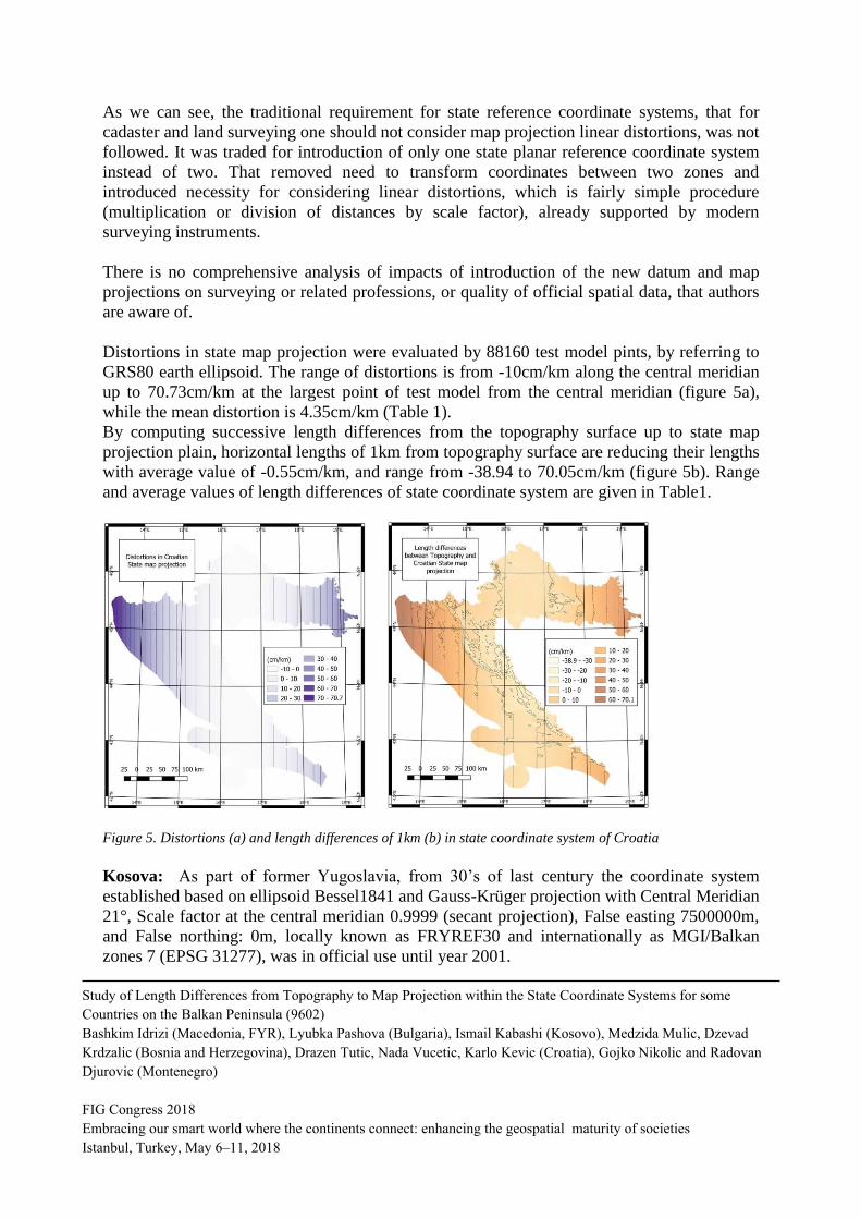
Distortions in state map projection were evaluated by 88160 test model pints, by referring to
GRS80 earth ellipsoid. The range of distortions is from -10cm/km along the central meridian
up to 70.73cm/km at the largest point of test model from the central meridian (figure 5a),
while the mean distortion is 4.35cm/km (Table 1).
By computing successive length differences from the topography surface up to state map
projection plain, horizontal lengths of 1km from topography surface are reducing their lengths
with average value of -0.55cm/km, and range from -38.94 to 70.05cm/km (figure 5b). Range
and average values of length differences of state coordinate system are given in Table1.
Figure 5. Distortions (a) and length differences of 1km (b) in state coordinate system of Croatia
Kosova: As part of former Yugoslavia, from 30’s of last century the coordinate system
established based on ellipsoid Bessel1841 and Gauss-Krüger projection with Central Meridian
21°, Scale factor at the central meridian 0.9999 (secant projection), False easting 7500000m,
and False northing: 0m, locally known as FRYREF30 and internationally as MGI/Balkan
zones 7 (EPSG 31277), was in official use until year 2001.
Study of Length Differences from Topography to Map Projection within the State Coordinate Systems for some
Countries on the Balkan Peninsula (9602)
Bashkim Idrizi (Macedonia, FYR), Lyubka Pashova (Bulgaria), Ismail Kabashi (Kosovo), Medzida Mulic, Dzevad
Krdzalic (Bosnia and Herzegovina), Drazen Tutic, Nada Vucetic, Karlo Kevic (Croatia), Gojko Nikolic and Radovan
Djurovic (Montenegro)
FIG Congress 2018
Embracing our smart world where the continents connect: enhancing the geospatial maturity of societies
Istanbul, Turkey, May 6–11, 2018

The state coordinate system of the Republic of Kosova (KOSOVAREF01) was defined on
year 2001, based on ETRS89 datum and Gauss-Krüger projection with -1dm/km distortion
(scale factor 0.9999) along the central meridian (21°E), equator as origin of latitude,
Greenwich as origin of longitudes, as well 7500000m false easting and 0m false northing.
(Idrizi, Bajrami and Lubishtani 2009). This coordinate system is the legal and technical base
for all official geodetic, topographic, cartographic and cadastral data in Kosova (www.kca-
ks.org).
Analyses for most appropriate state map projection for the Republic of Kosova have been
realized on year 2008 by Milot Lubishtani, Fitore Bajrami and Bashkim Idrizi (Idrizi, Bajrami
and Lubishtani, 2009), by computing distortions of some potential map projections in order to
adopt to national area, however the elevation factor was not take in to consideration!
Distortions in state map projection were evaluated by 10893 test model pints, by referring to
GRS80 earth ellipsoid. The range of distortions is from -10cm/km along the central meridian
up to -2.19cm/km at the largest point of test model from the central meridian (figure 6a),
while the mean distortion is -8.72cm/km (Table 1).
By computing successive length differences from topography surface up to state map
projection plain, horizontal lengths of 1km from topography surface are reducing their lengths
with average value of -22.13cm/km, and range from -50.25 to 12.86cm/km (figure 6b). All
calculated values of length differences of state coordinate system are given in Table1.
Figure 6. Distortions (a) and length differences of 1km (b) in state coordinate system of Kosova
FYRo Macedonia: Based on Law for Real Estate Cadastre of Macedonia and Regulation for
basic geodetic works in FYRo Macedonia, the Macedonian state coordinate system is defined
with Bessel 1841 earth ellipsoid, and Gauss-Krüger map projection with central meridian 21°E,
Study of Length Differences from Topography to Map Projection within the State Coordinate Systems for some
Countries on the Balkan Peninsula (9602)
Bashkim Idrizi (Macedonia, FYR), Lyubka Pashova (Bulgaria), Ismail Kabashi (Kosovo), Medzida Mulic, Dzevad
Krdzalic (Bosnia and Herzegovina), Drazen Tutic, Nada Vucetic, Karlo Kevic (Croatia), Gojko Nikolic and Radovan
Djurovic (Montenegro)
FIG Congress 2018
Embracing our smart world where the continents connect: enhancing the geospatial maturity of societies
Istanbul, Turkey, May 6–11, 2018

scale factor 0.9999, false easting 500000, and false northing 0m, Greenwich as origin of
longitudes and Equator as origin of latitudes (www.katastar.gov.mk). It was established by the
Military geographic institute of Belgrade on 30s of last century, internationally known as
MGI/Balkans zone 7 – EPSG: 31277.
Agency for Real Estate Cadastre of Macedonia intent to change the coordinate system in order to
use ETRS89 with GRS80 as geodetic datum for new coordinate system, by adopting new map
projection (www.katastar.gov.mk). For this issue, many researches have been conducted, but all
of them are based on distortion of map projection without including of elevation as factor for
choosing of state map projection during defining of state coordinate system (Idrizi 2005,
Ribarovski et all 1998, Ribarovski 1974, and Srbinoski 2000). At the Strategic plan for the work
of the Agency for Real Estate Cadastre of Macedonia for the period 2018–2020, institution is
going to prepare a study on choosing the optimal cartographic projection for the Republic of
Macedonia which will monitor the ETRS89 coordinate system, after it will have been put in
official use in the Republic of Macedonia (www.katastar.gov.mk).
Distortions in state map projection were evaluated by 25635 test model points (Idrizi 2014).
The range of distortions is from -10cm/km along the central meridian up to 25.16cm/km at the
largest-eastern point of test model from the central meridian (figure 7a), while the mean
distortion is -2.27cm/km (Table 1).
By computing successive length differences from topography surface up to state map
projection flat area (Idrizi 2014), horizontal lengths of 1km from topography surface are
reducing their lengths with average value of -16.01cm/km, and range from -51.56 to
19.48cm/km (figure 7b). All range and average values of length differences of state
coordinate system are given in Table 1.
Figure 7.Distortions (a) and length differences of 1km (b) in state coordinate system of Macedonia (Idrizi 2014)
Montenegro: From 30s of last century till year 2007, two projecting zones have been in
official use for the territory of Montenegro, inherited from the state coordinate system of
Study of Length Differences from Topography to Map Projection within the State Coordinate Systems for some
Countries on the Balkan Peninsula (9602)
Bashkim Idrizi (Macedonia, FYR), Lyubka Pashova (Bulgaria), Ismail Kabashi (Kosovo), Medzida Mulic, Dzevad
Krdzalic (Bosnia and Herzegovina), Drazen Tutic, Nada Vucetic, Karlo Kevic (Croatia), Gojko Nikolic and Radovan
Djurovic (Montenegro)
FIG Congress 2018
Embracing our smart world where the continents connect: enhancing the geospatial maturity of societies
Istanbul, Turkey, May 6–11, 2018

former Yugoslavia, defined by the Military Geographic Institute in Belgrade. Border between
two projecting zones was meridian 19°30’, east of which is the 7th zone with central meridian
21°, while on the west it is the 6th zone with central meridian 18° of MGI /Balkan zones.
Based on the Law on State Survey and Real Estate Cadastre, Article 24 ("Official Gazette of
the Republic of Montenegro" No. 29/07), the Universal Transversal Mercator (UTM)
projection was adopted as new state map projection. Whole country area belongs to UTM
zone 34N, with central meridian 21°E.
The reason for defining new state coordinate system is that the GRS80 ellipsoid more
coincides with the Earth dimensions, and most of the European countries have adopted the
ETRS89 reference coordinate system, defined as a straight, rectilinear, geocentric system,
which is firmly bound to the European lithosphere surface. This will facilitate the exchange of
geospatial data between Montenegro and other European countries in the future.
Distortions in state map projection were evaluated by 13331 test model pints, by referring to
WGS84 earth ellipsoid. From computed values, range of distortions is from -36.06cm/km at
the eastern point up to 13.01cm/km at the largest point of test model (western point) from the
central meridian (figure 8a), while the mean distortion is -13.07cm/km (Table 1).
By computing successive length differences from topography surface up to state map
projection flat area, horizontal lengths of 1km from topography surface are reducing their
lengths with average value of -29.81cm/km, and range from -70.46 to 11.21cm/km (figure
8b). All calculated values of length differences of state coordinate system are given in Table1.
Figure 8. Distortions (a) and length differences of 1km (b) in state coordinate system of Montenegro
5. RESULTS AND FINDINGS FROM TEST MODEL ANALYSES
Assessment and comparison of the length differences in a grid 1x1 km after successive
projection between four referent surfaces (earth surface, geoid, ellipsoid, and map projection)
Study of Length Differences from Topography to Map Projection within the State Coordinate Systems for some
Countries on the Balkan Peninsula (9602)
Bashkim Idrizi (Macedonia, FYR), Lyubka Pashova (Bulgaria), Ismail Kabashi (Kosovo), Medzida Mulic, Dzevad
Krdzalic (Bosnia and Herzegovina), Drazen Tutic, Nada Vucetic, Karlo Kevic (Croatia), Gojko Nikolic and Radovan
Djurovic (Montenegro)
FIG Congress 2018
Embracing our smart world where the continents connect: enhancing the geospatial maturity of societies
Istanbul, Turkey, May 6–11, 2018

have been realized. Seven values are evaluated: average linear deformations of 1km
horizontal lengths, range of differences, maximum and minimum difference values, and areas
with positive, negative, and without length differences.
The values for separate differences between four referent surfaces and successive differences
between earth surface and referent ellipsoid, and between earth surface and state map
projection for each point of test model are calculated. Thus for each point of test model, per
seven values have been calculated:
1. Length difference of 1km between topography and see level (geoid);
2. Length difference of 1km between see level (geoid) and referent ellipsoid;
3. Length difference of 1km between referent ellipsoid and state map projection;
4. Length difference of 1km between topography and referent ellipsoid; and
5. Length difference of 1km between topography and state map projection.
6.
Since the test model consists of 328 466 points, the total number of calculated values for
length differences in the seven countries reached up 11 496 310.
Differences between calculated values of above mentioned points 3 and 5 above are the
values of special interest for ours research; therefore these results are presented in the Table 1
for each country separately.
Table 1. Average and range of distortions and length differences in 1km in state coordinate systems of
Albania, Bosnia and Herzegovina, Bulgaria, Croatia, Kosova, Macedonia and Montenegro
Country Coordinat
e zones
Points of
test
model
Distortions between ellipsoid
and map projection
Length differences between
topography and map projection
Average Range Average Range
Albania 1 zone 28303 1.22cm/km 0 to
9.65cm/km -10.28cm/km
-39.97 to
3.77cm/km
Bosnia and
Herzegovina
Zone 5 4596 1.47cm/km -5.845 to
7.75cm/km -8.65 cm/km
-27.29 to
4.68cm/km
Zone 6 46471 -5.64cm/km -10 to
7.99cm/km -17.28cm/km
-56.49 to
4.43cm/km
Zone 7 130 6.88cm/km 4.86 to
7.99cm/km -2.27cm/km
-9.86 to
3.67cm/km
Whole
country 51197 -4.97cm/km
-10 to
7.99cm/km -16.46cm/km
-56.49 to
4.68cm/km
Bulgaria
UTM 34N 30184 4.88cm/km -25.07 to
37cm/km -7.62cm/km
-55.06 to
29.9cm/km
UTM 35N 80763 -20.09cm/km -40 to
36.62cm/km -26.53cm/km
-55.02 to
30.28cm/km
Whole
country 110947 -13.3cm/km
-40 to
37cm/km -21.39cm/km
-55.06 to
30.28cm/km
Croatia 1 zone 88160 4.35cm/km -10 to
70.73cm/km 0.55cm/km
-38.94 to
70.05cm/km
Kosova 1 zone 10893 -8.72cm/km -10 to
-2.19cm/km -22.13cm/km
-50.25 to
-12.86cm/km
Study of Length Differences from Topography to Map Projection within the State Coordinate Systems for some
Countries on the Balkan Peninsula (9602)
Bashkim Idrizi (Macedonia, FYR), Lyubka Pashova (Bulgaria), Ismail Kabashi (Kosovo), Medzida Mulic, Dzevad
Krdzalic (Bosnia and Herzegovina), Drazen Tutic, Nada Vucetic, Karlo Kevic (Croatia), Gojko Nikolic and Radovan
Djurovic (Montenegro)
FIG Congress 2018
Embracing our smart world where the continents connect: enhancing the geospatial maturity of societies
Istanbul, Turkey, May 6–11, 2018

Macedonia 1 zone 25635 -2.27cm/km -10 to
25.16cm/km -16.01cm/km
-51.56 to
19.48cm/km
Montenegro 1 zone 13331 -13.07cm/km -36.06 to
13.01cm/km -29.81cm/km
-70.46 to
11.21cm/km
From all calculated values, raster datasets with 1km spatial resolution have been developed
separately, for each country and/or projection zones. Since the analyses of points of test
model were conducted as five analyses between referent surfaces (upper points from 1 to 5),
per five raster datasets for ten projecting zones have been developed (in total 50 rasters):
- per five raster datasets with 1km spatial resolution for the countries with 1 projecting
zone (Albania, Croatia, Kosova, FYRo Macedonia and Montenegro),
- 10 raster datasets with 1km spatial resolution for 2 projection zones of Bulgaria, and
- 15 raster datasets with 1km spatial resolution for 3 projection zones of Bosnia and
Herzegovina.
-
Layouts for 14 of 50 raster datasets, per two for each of the seven countries are presented in
upper six figures.
Raster datasets have been developed to be used for practical issues by the general public and
industry, as open data. By this contribution, every professional user of state coordinate
systems will be able to obtain the values of reductions, undulations, distortions, as well length
differences between earth surface and state coordinate system in every point of the country
area.
The differences between the real lengths on earth surface (topography) and on a state map
projection (plain area with orthogonal coordinates) presented in Table 1 give an idea of the
quality of state geodetic coordinate systems. Results show clearly big differences in all
analyzed chases of the distortions of map projection and the length reduces from the Earth
surface to the state map projection. By comparing of calculated values we came to the next
general findings:
- differences between the distortion in state map projections and length differences
between the topography and the map projection are too large,
- largest length differences between the topography and the map projection doesn’t reach
same values with opposite prefixes,
- mean length differences between the topography and the map projection in all cases do
not have values nearby zero, and
- the range of length differences didn’t reach the criteria of uniform dispersion, which
was resulted with too large differences between areas with negative and positive linear
deformations.
Thus, we can summarize that during establishing of the state coordinate systems were not taken
into account all length reductions - differences beginning from the topography to the relevant map
projection.
Study of Length Differences from Topography to Map Projection within the State Coordinate Systems for some
Countries on the Balkan Peninsula (9602)
Bashkim Idrizi (Macedonia, FYR), Lyubka Pashova (Bulgaria), Ismail Kabashi (Kosovo), Medzida Mulic, Dzevad
Krdzalic (Bosnia and Herzegovina), Drazen Tutic, Nada Vucetic, Karlo Kevic (Croatia), Gojko Nikolic and Radovan
Djurovic (Montenegro)
FIG Congress 2018
Embracing our smart world where the continents connect: enhancing the geospatial maturity of societies
Istanbul, Turkey, May 6–11, 2018

6. CONCLUSIONS
In this paper, the analysis for length differences between the topography and map projections
with chase study of FYRo Macedonia (Idrizi 2014) has been extended by including other six
countries from the Balkan Peninsula. Obtained results for the territory of seven countries
covering about 330000km2, shows the same problems related to the too large differences
between distortions and length differences between the topography and the map projection, as
it was previously confirmed for the case of FYRo Macedonia.
It was a challenging task to process 328.466 points by defining their altitude and geoid
heights, as well as to calculate 11 496 310 values of length reductions between four surfaces.
Today, the powerful software and computers give an opportunity to accelerate and automate
such complex analyses using relevant mathematical model and large amount of data.
Developing and providing national datasets of lengths’ differences on a grid with cells 1x1
km covering the territories of seven Balkan countries can be successfully used by professional
users of the state coordinate systems in their countries. The obtained results are useful as the
corrections on the measured values-distances for many geodetic applications, such as the high
accuracy geodetic measurements, surveying, combination of GNSS and total station
measurements, special/local geodetic networks, transformation of the local geodetic networks
from free oriented into the state coordinate system, etc.
The performed analyses show that successive length differences between four surfaces, must
take into account during selecting of a most appropriate state map projection. Especially, the
study of the length reductions beginning from the topography up to the map projection is
indicative for big differences instead of the distortion values, which are usually calculated
between reference ellipsoid and map projection. This conclusion was verified by computed
linear deformation values (Table 1), which in all cases have largely avoided from the expected
values.
Based on the calculated values from the performed analyzes, we can conclude that similar
problems have an absolute number of the formal state coordinate systems, all over the world.
This research aims to contribute to further studies of defining a new approach for choosing the
most appropriate national map projection, in order to minimize the length differences between
topography and map projection, as well as to fulfill the criteria/standards of linear differences
between referent surfaces in state coordinate systems.
REFERENCES
Burkholder EF. 2004: Accuracy of Elevation Reduction Factor; www.globalcogo.com/ElevFact.pdf
Državna geodetska uprava 2009: Tehničke specifikacije za postupke računanja i podjelu na listove
službenih karata i detaljne listove katastarskog plana u kartografskoj projekciji Republike Hrvatske –
HTRS96/TM. URL: http://listovi.dgu.hr/Tehn_spec_HTRS96TM_v_1.0.pdf
Geodetski glasnik 1986. Zakon o premjeru i katastru nekretnina. Službeni list SRBiH, 22/84 p. 649.
Available online:
Study of Length Differences from Topography to Map Projection within the State Coordinate Systems for some
Countries on the Balkan Peninsula (9602)
Bashkim Idrizi (Macedonia, FYR), Lyubka Pashova (Bulgaria), Ismail Kabashi (Kosovo), Medzida Mulic, Dzevad
Krdzalic (Bosnia and Herzegovina), Drazen Tutic, Nada Vucetic, Karlo Kevic (Croatia), Gojko Nikolic and Radovan
Djurovic (Montenegro)
FIG Congress 2018
Embracing our smart world where the continents connect: enhancing the geospatial maturity of societies
Istanbul, Turkey, May 6–11, 2018

http://www.suggsbih.ba/GEODETSKI%20GLASNIK/GEODETSKI%20GLASNIK%2023/GG%2023
.htm
Gjata G. 2013: Mendim per projekt-vendimin”per percaktimin, realizimin dhe mirembajtjen e sistemit
gjeodezik shqiptar”. Departamenti i gjeodezise; Fakulteti i inxhinierise se ndertimit; Universiteti
Politeknik i Tiranes. Tirana. Albania.
Idrizi B. 2013: Developing Model for Utilization of Global Earth Gravimetrical Models in
Macedonian Territory, Abuja, Nigeria, FIG working week 2013.
Idrizi B. 2014: Length differences between topography and map projections; chase study: country
area of Macedonia; Proceedings, 5th International Conference on Cartography and GIS; Riviera,
Bulgaria. https://cartography-gis.com/docsbca/5ICCandGIS_Proceedings.pdf
Idrizi B., Bajrami F., Lubishtani M. 2009: Projecting of territory of the Republic of Kosova in several
most used state map projections; FIG WW 2009; Eilat, Israel.
Idrizi B., Ribarovski R., 2010: Historical overview, quality and current conditions of the geodetic
networks in Macedonia, Sydney, FIG working week 2010.
Mulić, M. 2012. Research on the impact of the realization of the ITRF to the coordinates, their
accuracy and the estimation of the velocity vectors of GPS stations in B&H. Dissertation. University
of Sarajevo, Faculty of Civil Engineering.
Mulić, M. 2018. Geodetski referentni sistemi. University of Sarajevo, Faculty of Civil Engineering.
Sarajevo, pp 232. ISBN 978-9958-638-50-3
Mulić, M., Vrce, E., Omićević, Dž., Đonlagić, E., 2015. Geodezija od Mesopotamije do Globalnog
Geodetskog Opažačkog Sistema. Geodetski glasnik, No. 46, pp.132-168
Narodne Novine 2004a: Odluka o utvrðivanju službenih geodetskih datuma i ravninskih kartografskih
projekcija Republike Hrvatske, Narodne novine 110/04, Vlada Republike Hrvatske. URL:
https://narodne-novine.nn.hr/clanci/sluzbeni/2004_08_110_2107.html
Narodne Novine 2004b: Ispravak Odluke o utvrðivanju službenih geodetskih datuma i ravninskih
kartografskih projekcija Republike Hrvatske, Narodne novine 117/04. URL: https://narodne-
novine.nn.hr/clanci/sluzbeni/2004_08_117_2206.html
Nikolli P., Idrizi B., 2011: Coordinate Reference Systems Used in Albania to Date; FIG WW 20111;
Marrakech, Morocco.
Ribarovski R. 1978: Theoretical aspects for establishing of stereographical projection for the territory
of S.R.Macedonia; Habitation thesis; Faculty of civil engineering university center for mathematical-
technical sciences, UKIM; Skopje.
Ribarovski R. et all, 1998: Choice of the best cartographic projection for presenting of territory of
Republic of Macedonia; Skopje.
Sickle JV., Dutton JA. 2017: Elevation factor; Penn State College of Earth and Mineral Sciences.
https://www.e-education.psu.edu/geog862/node/1815
Skuka Q., Kuka N. 1997: Propozim per te kaluar ne nje sistem koordinativ te ri (Proposal to move to a
new coordinate system); Revista gjeodezike 2/3/97; Tirana, Albania.
Srbinoski Z. 2000: Supplement to investigation for defining of new states cartographic projection;
PhD Disertation; Faculty of Civil Engineering; Skopje. Macedonia.
Study of Length Differences from Topography to Map Projection within the State Coordinate Systems for some
Countries on the Balkan Peninsula (9602)
Bashkim Idrizi (Macedonia, FYR), Lyubka Pashova (Bulgaria), Ismail Kabashi (Kosovo), Medzida Mulic, Dzevad
Krdzalic (Bosnia and Herzegovina), Drazen Tutic, Nada Vucetic, Karlo Kevic (Croatia), Gojko Nikolic and Radovan
Djurovic (Montenegro)
FIG Congress 2018
Embracing our smart world where the continents connect: enhancing the geospatial maturity of societies
Istanbul, Turkey, May 6–11, 2018

State Gazette №63/17.08.2012: Instruction № RD-02-20-12/03.08.2012 „For transformation
of the existing data and materials into BGS 2005“, Ministry of Regional Development and
Public Works.
State Gazette, N 61/06.08.2010: Ordinance № 153 of 29.07.2010 for introduction of
Bulgarian Geodetic System 2005
State Gazette, N 62/ 10.08.2010: Regulation № 2 of 30.07.2010 for the Definition ,
Realization and Maintenance of the Bulgarian Geodetic System 2005, Ministry of Regional
Development and Public Works and Ministry of Defense,
Voser S. 2001: Map projections for the layman; Map projections for Europe; Institute for
Environment and Sustainability; Joint Research Centre.
HTTP:// (March, 2018)
http://asig.gov.al/english/index.php/2014-11-06-22-35-05/publikime/200-krgjsh-2010
http://asterweb.jpl.nasa.gov
http://earth-info.nga.mil/GandG/wgs84/gravitymod
http://geographiclib.sourceforge.net/cgi-bin/GeoidEval
http://kca-ks.org/legjislacioni
http://srtm.csi.cgiar.org
http://www.katastar.gov.mk/en/documents/strategic-plan-for-work-of-the-arec
http://www.katastar.gov.mk/прописи/закони
https://www.eea.europa.eu/data-and-maps/data/eu-dem
BIOGRAPHICAL NOTES
Bashkim Idrizi (corresponding author) is full time university lecturer at the geodesy and
geoinformatics department of the University “Mother Teresa” in Skopje, part time lecturer at
geodesy department of the University of Prishtina “Hasan Prishtina” in Prishtina, and
president of the Geo-SEE Institute in Skopje. His research interests are cartography, map
projections, coordinate reference systems, SDI and GIS.
Lyubka Pashova ([email protected]) is Associate Professor in the Geodesy
Department at the National Institute of Geophysics, Geodesy and Cartography, Bulgarian
Academy of Sciences. She leads and participated in several projects in the field of geodesy
and geodynamics at national and international level. Since October 2014 she is GEO Principal
Alternate of Bulgaria in the Group on Earth Observations.
Ismail Kabashi ([email protected]) is an employee in Vermessung ANGST GmbH
ZT, Vienna as project manager for Planning and execution of Cadastre and Geomonitoring
Projects. He works as a geodesy engineering Professor at the University of Prishtina-Kosova
since year 2014. He is the author of many papers published and presented in national and
international scientific conferences related to geodesy and engineering geodesy, as well as the
author of script for students in geodesy engineering field.
Study of Length Differences from Topography to Map Projection within the State Coordinate Systems for some
Countries on the Balkan Peninsula (9602)
Bashkim Idrizi (Macedonia, FYR), Lyubka Pashova (Bulgaria), Ismail Kabashi (Kosovo), Medzida Mulic, Dzevad
Krdzalic (Bosnia and Herzegovina), Drazen Tutic, Nada Vucetic, Karlo Kevic (Croatia), Gojko Nikolic and Radovan
Djurovic (Montenegro)
FIG Congress 2018
Embracing our smart world where the continents connect: enhancing the geospatial maturity of societies
Istanbul, Turkey, May 6–11, 2018

Medžida Mulić ([email protected]) works at University of Sarajevo at Faculty of
Civil Engineering-Department of Geodesy and Geoinformatics. Her research interests are
focused to precise satellite positioning and navigation and reference systems.
Dževad Krdžalić ([email protected]) works at University of Sarajevo at Faculty of
Civil Engineering-Department of Geodesy and Geoinformatics. He is PHD students and
works as an assistant, teaching on practical aspects for the students at bachelor and master
program, for the courses on Geodetic reference systems, Satellite geodesy and Land survey
for bachelor students and Satellite Navigation for master students.
Dražen Tutić ([email protected]) is an Assistant Professor at the Faculty of Geodesy,
University of Zagreb, Croatia. His research interests are map projections, cartography and
GIS. His special interest is automation of cartographic tasks and writing computer programs.
Karlo Kević ([email protected]) is a student at master's study of Geodesy and Geoinformatics
at the Faculty of Geodesy, University of Zagreb, Croatia. His interests include geodetic
datums and map projections.
Nada Vučetić ([email protected]) is a Professor at the Faculty of Geodesy, University of
Zagreb, Croatia. Her research interests are cartography, geographic information systems and
programming.
Gojko Nikolic ([email protected]) gained his PhD from the University of Montenegro’s
Institute for Geography, Niksic. He has participated as an associate or a member of a
professional team in the development of several scientific studies and research projects,
including international projects, in which his professional and scientific engagement was
focused on solving methodological problems, making corrections to numerous maps, atlases,
and topographical, geographical and GIS databases in several scientific fields.
Radovan Djurovic ([email protected]) is an Assistant Professor at the Faculty of Civil
Engineering, Podgorica, University of Montenegro. His research interests areas: cadastre, land
survey and engineering geodesy.
CONTACTS OF CORRESPONDING AUTHOR
Assoc.Prof.Dr. Bashkim IDRIZI Institution: University “Mother Teresa” – Skopje; University of Prishtina “Hasan Prishtina”; and South East
European Research Institute on Geo Sciences - Skopje.
Address: str. Djon Kenedi, 25/4-20; City: 1010 Skopje-Chair; Country: Macedonia.
Tel. + 389 75 712-998
Email: [email protected], [email protected], [email protected]
Web site: www.facebook.com/Prof.Dr.Bashkim.Idrizi; www.unt.edu.mk; www.uni-pr.edu; www.geo-see.org
Study of Length Differences from Topography to Map Projection within the State Coordinate Systems for some
Countries on the Balkan Peninsula (9602)
Bashkim Idrizi (Macedonia, FYR), Lyubka Pashova (Bulgaria), Ismail Kabashi (Kosovo), Medzida Mulic, Dzevad
Krdzalic (Bosnia and Herzegovina), Drazen Tutic, Nada Vucetic, Karlo Kevic (Croatia), Gojko Nikolic and Radovan
Djurovic (Montenegro)
FIG Congress 2018
Embracing our smart world where the continents connect: enhancing the geospatial maturity of societies
Istanbul, Turkey, May 6–11, 2018