Embed Size (px)
Citation preview
FCUP Floristic studies on urban ecological corridor: Via de Cintura Interna (Porto)
i

FCUP Floristic studies on urban ecological corridor: Via de Cintura Interna (Porto)
ii
FCUP Floristic studies on urban ecological corridor: Via de Cintura Interna (Porto)
iii
Acknowledgement
In first place, I would like to thank my supervisor, Prof. Rubim Almeida, for his
help and encouragement and support during the entire execution of this dissertation.
I also thank Prof. José Lameiras for his help in the beginning of this thesis.
For help in the survey phase, I want to thank Vasco Silva and Ana Barreira,
without their help the survey wouldn’t be possible.
My aunt Carla Guedes, for her help, support, encouragement and advise so
many times required.
My mom, Maria Almeida, for always believing in me and in my abilities, and never
letting me gives up even when I wanted to.
Lastly, to all that, in a way or the other, contributed to the creation of this thesis
and help me to accomplished my objectives, my friends and family.
Thank you very much.

FCUP Floristic studies on urban ecological corridor: Via de Cintura Interna (Porto)
iv
FCUP Floristic studies on urban ecological corridor: Via de Cintura Interna (Porto)
v
Resumo
As cidades em crescimento e o aumento da poluição destruíram habitats limitando
a conexão entre os territórios, por esse motivo surgiu o conceito de corredor verde
permitindo unir estes territórios fragmentados.
William Whyte surgiu com o termo “Greenway”, em meados dos anos 60, para
descrever o conceito de um corredor linear que conecta zonas verdes permitindo a
passagem de animais e plantas, mas que não permitia a passagem de automóveis.
Este conceito tem vindo a evoluir ao longo dos anos até se chegar ao conceito de
um corredor verde que apesar de continuar a possuir um caracter linear, apresenta
também múltiplas funções, entre elas, funções ecológicas e funções sociais.
A Via de Cintura Interna, na cidade do Porto, é uma estrutura viária que possui ao
longo do seu comprimento taludes com vegetação que poderão apresentar algumas
carateristicas associadas ao conceito de “greenways”.
Neste trabalho pretendeu-se estudar a flora presente nos taludes da VCI, verificar
se estes se comportam como um “greenway”, averiguar se as espécies
encontradas se dispersam ao longo do corredor ou, ainda, se estas espécies
apresentavam algum padrão de distribuição.
Os resultados indicam que estes taludes não se comportam como um “greenway”
pois encontram-se ausentes algumas das várias funções que caracterizam aquelas
estruturas. O grande número de espécies encontradas não aparentou ter um
padrão específico de distribuição. Muitas destas espécies eram exóticas mas a
maioria não era invasora.
Estes resultados permitiram a obtenção do primeiro levantamento florístico daquela
estrutura, identificar questões pertinentes sobre a utilização dos taludes e entre
outras questões, perceber como se comporta a vegetação ao longo de uma via
rodoviária urbana.
Palavras-chave: Greenway; corredor verde; fragmentação de habitats; ecologia da
estrada; conectividade
FCUP Floristic studies on urban ecological corridor: Via de Cintura Interna (Porto)
vi
Abstract
The growth of cities and the increase in pollution destroyed habitats by limiting the
connection between separated territories. Thus, the concept of green corridor,
allowing this fragmented territories to become connected facilitating the movement
of life, has arose.
William Whyte suggested the word “Greenway”, in mid sixties, to describe the
concept of a linear corridor that connects green zones allowing the movement of
animals and plants but not of motorized vehicles.
This concept evolved over the years until the concept of a green corridor that still is
a linear structure but also introduce multiple function, among them, ecological and
social purposes.
The Via de Cintura Interna, in Porto, is a road infrastructure that has embankments
with vegetation along its entire length and could show some characteristics
associated to the “greenway” concept.
In this work embankments flora of VCI was studied for the first time and we sought
to determine whether there were floristic patterns of dispersion, namely gradients.
The results indicate that the embankments don’t behave as a “greenway” because
they don’t show many of the functions associated to such a structure. The high
number of species found didn’t appear to have a specific pattern of distribution.
Many of the species present were exotic but not many were invasive ones.
These results allow better knowledge of the flora of the area, identify some pertinent
questions about embankments functions and understand how flora behaves along
an urban road.
Key words: Greenway; green corridor; habitat fragmentation; road ecology;
connectivity

FCUP Floristic studies on urban ecological corridor: Via de Cintura Interna (Porto)
vii
FCUP Floristic studies on urban ecological corridor: Via de Cintura Interna (Porto)
viii
Index
Acknowledged...................................................................................iii
Resumo.............................................................................................v
Abstract ............................................................................................vi
Figures Index.....................................................................................x
Tables Index.....................................................................................xi
Greenways........................................................................................1
Evolution of the concept ........................................................................2
Greenways in the present ......................................................................4
Advantages and disadvantages of greenways ............................................6
Ecology of greenways ..........................................................................8
Via de Cintura Interna......................................................................11
Objectives of the work ....................................................................12
Methodology....................................................................................13
Results.............................................................................................14
Discussion and Conclusions............................................................35
Bibliography.....................................................................................39

FCUP Floristic studies on urban ecological corridor: Via de Cintura Interna (Porto)
ix
FCUP Floristic studies on urban ecological corridor: Via de Cintura Interna (Porto)
x
Figures Index
Figure 1: Map of VCI. Picture taken from the Google Earth. The VCI highway is
represented in dark yellow. The surveyed points are indicated by the yellow
drawing-pins.............................................................................................................12
Figure 2: Relation between number of species and the points where they were
observed...................................................................................................................24
Figure 3: Scheme of VCI map showing both sides of the VCI. The arrows show the
names given to which side of the highway...............................................................24
Figure 4: a).This graphic show the relation between the width of the embankment, in
metres, and the number of species present, for the east corridor. b) Relation
between the width of the embankment, in metres, and the number of species
present, for the west corridor...................................................................................25
Figure 5: a) Represent the relation between the number of species present in the
embankments and the distance from the river, in kilometres, for the east corridor. b)
Relation between the number of species present in the embankments and the
distance from the river, in kilometres, for the west
corridor......................................................................................................................27
Figure 6: a). Show the relation between the number of species present in the
embankments studied and the distance of each point from sea, in kilometres, for the
east corridor. b) Relation between the number of species present in the
embankments studied and the distance from that point to sea, in kilometres, for the
west corridor...........................................................................................................28
Figure 7: Graphic 5: a) Show the number of species present in the points study and
its distance to the closest green zone, in metres, for the east corridor. b) The
number of species present in the points study for the west embankments and the
distance to the closest green zone, in metres. For both graphics, green bar
represents the distance to the closest green zone and the red bar represents the
number of species. The bars are arranged by the survey points (the number
indicated in the x axis is the number given to the point
surveyed).............................................................................................................29
FCUP Floristic studies on urban ecological corridor: Via de Cintura Interna (Porto)
xi
Tables Index
Table 1: Measures obtained during the surveys or using a GIS: measures of slope,
width, sun exposure, corridor use, maintenance, accessibility, fencing, distance from
the river, distance from sea and distance to the nearest green space, associated
with the 50 points of survey, were taken...................................................................15
Table 2: Species of the floristic surveys, their respective families and the points in
which they were found..........................................................................................18
Table 3: List of the species distributed in the survey points where they were found,
for the west corridor.................................................................................................30
Table 4: List of the species distributed in the survey points where they were found,
for the east corridor..................................................................................................32
FCUPFloristic studies on an urban ecological corridor: Via de Cintura Interna (Porto)
1
Greenways
In our society, the urban environment is of great importance and in many cases
nature is put aside and neglected; sometimes it is used to conclude a project by
filling an empty space (Magalhães, 1992), while cities grow and alter profoundly the
landscape that surrounds them by building infrastructures that modify the
topography, by introducing exotic plants, creating barriers or building roads,
generating microclimatic areas, disturbing natural processes, such as ecological
succession and destroying habitats connectivity by blocking animal and plants
movement between patches (Lowry, 1967; Davis, 1973; Seiler, 2001;
Hostetler,2011).
With the growing importance of the road in the human society, because of the
expansion of cities, a new field of study appeared - road ecology - devoted to study
the negative effects that roads and traffic corridors may create and the ways to
mitigate them (Ranta, 2008).
Since the industrialization era, cities have become larger and filled with smoke,
dust, heat, noise and many other hazards (Davis, 1973), most of the air and noise
pollution mentioned were caused by increase of traffic and by the growth of
habitants numbers living in cities (Ranta, 2008). The growth of cities caused by the
increase of population, doesn’t only impact the human lives but also the natural
environment such as damage plants or even promote the disappearance of habitats
with the consequent extinction of animal and plant species (Shaw, 1903;
Mcdermontt 1961; Davis, 1973).
The destruction of the natural landscape made the urban areas highly modified
and the habitats very fragmented. The lack of green spaces in cities encouraged the
creation of urban greenways and wildlife corridors in the urban landscape planning
(Angold, 2006), as a way to minimize the negative effects associated to that fact.
In an ideal situation all corridors should be naturally made, using the surrounding
environment to structure them. Unfortunately most of the green corridors, despite
being associated with natural features, are manmade and may follow human
created features such as railroads (Flink, 1993; Magalhães, 1992).
The term greenway gives us two different images: on one hand, the word green
may reminds us of nature and places like forests, rivers or a wide green plain; on the
other hand, the word way implies movement, paths or roads (Flink, 1993).
FCUP Floristic studies on urban ecological corridor: Via de Cintura Interna (Porto)
2
Although the term “greenway” is recent, accordingly to Ervin Zube (1995) the
concept has more than 100 years and could even go back to the Roman times and
the building of their roads (Searns, 1995; Seiler, 2001).
In the literature, there isn’t an absolute definition for the term greenway, and it is
modified accordingly with the country or the author. Other names given to
greenways are ecological infrastructures, wild life corridors or green corridors
(Ahern, 2002), so it is extremely difficult to define what a greenway is or is not.
Some authors admit that a greenway is connected to forests or even riverbanks
(Flink, 1993), while others consider it a secondary green structure that connects
different spaces for the use of people, as walkways (Magalhães, 1992), or even as a
set of lands that are protected for various uses (Ahern, 2002). Ahern (1995) defines
greenways as “...networks of land that are planned, designed and managed for
multiple purposes including ecological, recreational, cultural, aesthetic, or other
purposes compatible with the concept of sustainable land use”. Despite the variety
of definitions, they all have in common the fact that it is a green, more or less linear
structure, with a defined objective, at the ecological or social level.
There are several types of greenways. Some are more natural/rural, connected
with streams, forests or riparian corridors, others are related to the connection
between rural areas and urban ones, like river ways or walk ways that allow access
to nature for urban citizens and take the rural areas into the city, and even just
urban, connecting the fragmented urban land such as traffic corridors, park ways or
just a network of small gardens (Flink, 1993;Taylor,1995; Maestas,2003; Bryant,
2006; Frischenbruder, 2006; Angold, 2006; Hahs, 2006).This work will only refer to
the urban ones that connect fragmented land in cities.
1.1. Evolution of the concept
Some authors proposed an evolution of the greenway concept as presenting
three different and consecutive phases.
The first phase started before the eighteenth century and ended in the second
half of the twentieth century. It included structures such as axes, boulevards our
even parkways. In this phase the term greenway wasn’t used yet.
The structures built during this phase were used for human and working animals’
movement or for aesthetical purposes and intended to bring the rural felling into the
city but those corridors weren´t prepared for the use of motor vehicles such as cars
or motorbikes (Searns, 1995).
FCUP Floristic studies on urban ecological corridor: Via de Cintura Interna (Porto)
3
It was in the industrial era that the concept of urban green space, as a substitute
of nature in cities, started with the creation of parks and public foot walks
(Magalhães, 1992) in an attempt to reintroduce nature in cities.
They provided connection between different points of interest and could present
themselves in the form of walkways for strolling along, or as paths for horse-drawn
carriage rides. They always respected the topography and the hydrology of the land
(Ahern, 2002). In some cases they were corridors along canals.
This phase also represents the beginning of the greenbelt movement
(Magalhães, 1992; Searns, 1995; Zube, 1995; Ahern, 2002). This idea consists in a
strip of rural land that defines the limits of the urban area preventing the expansion
of the city limits and was based in political boundaries. Although different, greenbelts
and greenways have some similarities such as the linear form or the buffering
capacity.
These corridors share the movement function of the corridors of the present
days.
The second phase started in the sixties and went up to the mid-eighties. William
Whyte is associated with the use of the word “Greenway”, which was related to a
corridor that runs along a river and follows the topography patterns of the city limits,
including some parks and other green structures for public use. During this period,
the automobile becomes one of the most important means of locomotion in cities.
Therefore, the levels of pollution increased and the need for locations for non-
motorized route travels and without air pollution (Searns, 1995; Zube, 1995; Ahern,
2002) became a must. These corridors were paved allowing for bicycle rides, walks,
as well as hiking trails.
Since then, many other corridors were created and most of them were associated
to riversides, shorelines or other canals. With the growth of this movement came
another type of corridors (Searns, 1995; Walmsley, 1995; Ahern, 2002), these were
associated with the abandoned railroads. The railroad corridors had the advantages
of having a predetermined linear structure.
These corridors constitute a more accessible adaptation of the nature trails in
cities, allowing a greater contact between the common city people and nature, being
accessible for a bigger segment of population. This didn’t occur in the previous
phases, where the corridors were mainly accessible to wealthy people (Searns,
1995).
This third phase began in mid-eighties and it is still in development. In this phase
there is a broader concept of greenway, that takes into account more functions and
FCUP Floristic studies on urban ecological corridor: Via de Cintura Interna (Porto)
4
objectives. It is in these corridors that the idea of more environmentally concerned
greenways began (Searns, 1995; Zube, 1995; Ahern, 2002).
This new phase is characterized by linear structures that are left alone and
preserved with the intention of habitat protection and avoiding biodiversity reduction.
The initial corridors were paved, but in the beginning of the nineties, they were
being built unpaved with more natural features.
These greenways were characterized as recreational places while allowing, at
the same time, in some cases, much easier access to rivers and other water lines
on the urban mosaic than the parks and wilderness.
Unlike the two previous phases, in this one, corridors are not just seen as
recreational or aesthetic spaces but also as tools to prevent or help solving
ecological problems. These “greenways” are multi-functional, serving several
objectives such as education, reduction of hazards like pollution or erosion,
recreation and many others such as conservation of habitats. They also promote
cultural or historical learning (Flink, 1993; Searns, 1995; Zube, 1995; Ahern, 2002;
Bryant, 2006).
Some schools adopted one segment of “greenway” and are using them to teach
students about nature and how to preserve it (Searns, 1995; Walmsley, 1995;
Ahern, 2002).
Every new generation of “greenways” is more complex than the previous ones,
and is shaped in the culture and education of its users.
1.2. Greenways in the present
In the present day the greenway concept was found by the consensus between
ecologists and landscape planners with the goal of protecting and preserving nature
by using networks of land (Ahern, 2002).
The concept is very adaptive and flexible enough to support its application with
various combinations of needs, values and conditions allowing for builders and
community to dialogue (Flink, 1993; Ahern, 2002).
As mentioned before there are very different types of greenways. They can be
associated with a waterfront such as rivers or shorelines, as a way to contain and
preserve water quality. They can be associated with wildlife in its most pure form
and sometimes used with ecological purposes such as providing migration routes.
Others are associated to recreational services as trails and paths or they can be
associated to roads, highways or waterways, in order to provide pedestrian routes
FCUP Floristic studies on urban ecological corridor: Via de Cintura Interna (Porto)
5
and scenic or historic routes. Another type of “greenway” is a network of green
infrastructures connecting valleys or rivers with the idea of uniting the various open
spaces serving different objectives. All the different types can overlap, creating
greater greenways that present multiple purposes (Flink, 1993; Fabos, 1995;
Walmsley, 1995; Ahern, 2002; Frischenbruder, 2006).
According to Ahern (2002), the primary goal for the creation of greenways is the
realization of a sustainable network of protected lands, and for that a mix of
landscape ecology theories and several methods of landscape planning can be
used.
The actual “greenways” may present various values to those who use them, they
can be a mere non-polluting area, a trail for horse riding or just for strolling, it can
protect the quality of the water, preserve wildlife habitat, buffering land use or even
safeguard some present or past characteristics of the region. They can also
separate people from the traffic physically and in some cases provide business
opportunities by attracting tourists (Flink, 1993; Magalhães, 1992).
The present greenways aim to protect urban lands and urban landscape and so
they tend to be located closer to the focus of pollution: where people live and work,
allowing for a better quality of life (Mcintyre, 2000; Frischenbruder, 2006; Ignatieva,
2011).
Nowadays, greenways are also associated with economy. The economic
exploitation of the land has been causing many problems such as the degradation of
the ecosystems by agriculture or even tourism (Jiangue Liu et al, 2007). It has been
verified that land around greenways, parks or trails is more valuable than land that
doesn’t have a green structure nearby, because those places tend to attract people
(Flink, 1993; Alberti, 1996).
The creation of greenways needs to respect the “continuum natural”, meaning
that corridors should be built respecting the surroundings and associated with the
quality of human life. This is a granted right by the Portuguese Constitution
(Magalhães, 1992).
The sustainability, sought by urban planners, might be obtained by promoting the
existence of the multiple processes simultaneously, by integrating the cultural and
aesthetical resources and values (Ahern, 2002). Another characteristic of a
greenway is accessibility, and that involves the access and transportation to and
from the greenway. That is important because the nearby land could be privately
owned, which means that the land isn’t accessible to everyone (Flink, 1993).
Besides the previously mentioned objectives, such as ecological protection,
recreational features, cultural resources, aesthetical or educational aspects,
FCUP Floristic studies on urban ecological corridor: Via de Cintura Interna (Porto)
6
greenways must also have a linear form, the capacity for linking patches allowing
movement and transportation of material, species or nutrients. (Flink, 1993).
These corridors tend to be longer in length than in width, the last varying
according to the corridor, they should be continuous but sometimes it’s impossible
because of the network connections (Flink, 1993; Ahern, 2002).
Greenways could be studied in different scales such as local, regional, national
our international because sometimes they expand beyond the political frontiers.
When it comes to planning greenways, there isn’t a large consensus because it is
necessary to take into account the previous land use and land cover as well as the
historical context of the land (Ahern, 2002; Bryant, 2006).
The implementation of corridors may not be possible everywhere, so the
implementation plans need to be made according to the region and the cultural
landscape (Flink, 1993; Ahern, 2002; Ranta, 2008).
For example, authors such as Flink (1993) and Dawson (1995), propose six key
indicators for a greenway, namely slope, vegetation, geology, soil, wildlife and
hydrology. Lower slopes were recommended for use in greenways design because
they facilitate the walk and use, especially when closer to waterlines. Vegetation
types may help to identify the uses that the corridor supports and geological
analyses may detect some features such as faults or others that are points of
interest. The previous use given to the land and the type of soil as well as its
hydrology may help to understand the potential of the area as a corridor. Also
studying the presence of land wildlife allows us to determine if the corridor is a
walkthrough path for the different species.
According to many authors there is still much more to do in this new generation of
greenways (Flink, 1993; Dawson, 1995; Searns, 1995; Ahern, 2002; Bryant, 2006;
Hostetler, 2011).
1.3. Advantages and disadvantages of greenways
1.3.1.Advantages
The creation of greenways carries along some very important advantages: they
may control the flow of nutrients and sustain levels of land functions. These
corridors can prevent processes of erosion and mass wasting, help to mitigate
negative impacts such as invasion of non-native plant species, stabilizing the
ecological factors that might favour the spread of invasive species and/or protect
against habitat fragmentation and protect and promote animal and plant diversity
FCUP Floristic studies on urban ecological corridor: Via de Cintura Interna (Porto)
7
(Bryant, 2006). Corridors may also help clean the air and water, being this effect
maximized by corridors length (Flink, 1993; Dawson, 1995; Fabos, 1995; Ahern,
2002; Frischenbruder, 2006; Ranta, 2008).
It might raise environmental awareness by making a profound impact on the
physical and spatial characteristics of the landscape (Searns, 1995; Ahern, 2002).
The fact that the resources are more concentrated in the corridors may allow a
better protection in a smaller area of land, which will facilitate monitoring, and
allowing for less land to be withdrawn from other uses (Flink, 1993; Ahern, 2002).
There are also some benefits for the community. On one hand, it would reduce
costs caused by the ecosystem disturbances and the people that use the space. On
the other hand, it could bring business opportunities and the increase of the property
value (Flink, 1993).
Some corridors have open spaces that may be used for recreational activities,
allowing its users a closer contact with nature (Flink, 1993; Ahern, 2002; Bryant,
2006; Frischenbruder, 2006).
Lastly, there is another more abstract advantage, and it is related to the
connection between humans and nature, enabling people to feel better with
themselves and their surroundings and appreciate nature by strolling in trails or
offering visual relief. This connection also allows healthier life style by providing a
place to walk without pollution. The most important advantage of greenways is the
capacity to admit multiple functions at the same time (Flink, 1993; Fabos, 1995;
Searns, 1995; Ahern, 2002; Ranta, 2008; Samways, 2011).
1.3.2. Disadvantages
Some authors argue that there’s no need for corridors because species are
capable of dispersion in the landscape without them (Ahern, 2002).
Disadvantages include several types of problems and, of course, are noted by
different authors. Therefore the difficulty into connecting different functions in the
same corridor as well as the management of the greenways are pointed as
disadvantages due to habitat degradation, for instance, caused by maintenance
works such as mowing of the grass (Ranta, 2008).
Also when corridors are not ecologically balanced, they can promote the
dispersion of invasive species into the protected area creating disturbance (Dawson,
1995; Fabos, 1995; Ahern, 2002; Frischenbruder, 2006; Samways, 2011).
Corridors can change the physical, cultural and visual landscape by leading to a
greater uniformity of the land, being almost impossible to maintain a pristine state in
all and each greenway (Dawson, 1995). The concept of greenway may obscure
FCUP Floristic studies on urban ecological corridor: Via de Cintura Interna (Porto)
8
other projects that could be more important to the protection of the ecosystems as a
whole (Ahern, 2002).
The greenways sometimes expand beyond political boundaries causing political
and economic problems (Ahern, 2002).
Lastly the greenways initiative, may harm private owners who lose their lands or
see them being occupied by people (Flink, 1993).
1.4. Ecology of greenways
Biodiversity defined by Bryant (2006) as “... the variety and variability among
living organisms and the ecological complexes in which they occur“ is a current
theme that is being discussed all over the world due to the dangers of its
disappearance and the search for ways of protecting it.
One way to prevent these extinctions may be the greenways which are systems
or networks connecting the remaining open spaces and wild areas (Hostetler, 2011)
that have been increasingly fragmented. Fragmentation is the destruction of the
connection between patches that lead to the lack of habitat and the extinction (Flink,
1993) or the isolation of species (Dawson, 1995) and may be derived from the
drastic habit transformations (Pereira, 2007).
According to Dawson (1995): “the fragmented corridors have the disadvantage of
separation from basic landscape patterns, however they may have some value as
“stepping stones” for species with high dispersal potential”, even so, these corridors
need to be connected to larger parks or reserves. Private gardens in the
surrounding of corridors can be very important stepping stones (Ignatieva, 2011).
The extreme weather conditions force species to move in order to find better
conditions (Roy, 2010). Natural corridors help species escape from danger,
performance, fire and so on, but the narrow ones could actually trap species, doing
little to their survival (Flink, 1993).
Many plants and animals use corridors as crossing points, while others inhabit
the space. These habitats are semi-natural, in most cases, and are in the earlier
stages of the ecological succession. One of the primary objectives of greenways is
to encourage animals and plants to move into the urban fabric, that is called
connectivity and it is related to the promotion of the movement of species (Pereira,
2007). Sometimes these corridors may act as buffers between rural and urban
fringes (Taylor, 1995), trying to maintain sustainability, which imply the maintenance

FCUP Floristic studies on urban ecological corridor: Via de Cintura Interna (Porto)
9
of the capacity for natural ecosystems to sustain human life over time (Alberti,
1996).
Roads are paved areas that extend outward and receive road maintenance. The
roads have ecological effects on the land that surrounds them. The effects extend
for some metres creating a road effect zone that is highly asymmetric because of
the directional flows and the spatial patterns on opposite sides of a road (Forman,
2000).
The sides of the roads and railroads are typically corridor habitats, and have a
predominance of edge species (Ranta, 2008). In some cases, this structure will
enter a built area and it is modified to build traffic embankments for the pedestrians
(Magalhães, 1992).
The abundance and the richness of the species that exist in the habitat vary
according to the area, connectivity and the continuity of the patch. The pioneer and
tall herbs survive longer in infertile substrate and under continual disturbance
(Angold, 2006) such as the competition for available nutrients and space, between
non-native species and native species (Zipperer, 2009).
Human population has been living mostly in cities that are organized systems of
interacting biophysical and socioeconomic components (Alberti, 1996). Urban is the
name given to a densely populated area, such as cities, and urbanization is the
relation between ecological and social phenomena (McIntyre, 2000). It is believed
that urban development causes the increase of biodiversity loss (Hepinstall, 2008).
The greenways associated to these areas serve as urban biodiversity protection
mechanisms (Bryant, 2006).
Species that may occur in the urban corridors have a wider distribution and may
occur in different corridor types. According to Angold (2006) it’s possible that the
nearby area of the corridors doesn’t influence the species richness unless the
corridor is near derelict and wasteland sites. In his words “green corridors may
make little difference to the diversity of plants… in towns and cities…”
These “ecosystems” can vary in the short distance because of the pressures to
which they are subject to by the surroundings (Hostetler, 20011) or even by the
management.
This management may include a regular mowing to keep the habitats in the early
stages of succession and are influenced by aesthetic values and traffic safety
(Ranta, 2008), creating an ecosystem that depends on humans to its sustainability
(Jianguo Liu et al, 2007). These mowing regimes should vary according to the
species that may exist in the place (Ranta, 2008).
FCUP Floristic studies on urban ecological corridor: Via de Cintura Interna (Porto)
10
Even though this isn´t required, it is recommended that the green corridor should
be continuous to help the connectivity, but most of times highways tend to interrupt
major travel corridors (Flink, 1993; Forman, 2000).
The road effect may cause habitat invasions, the salt “produced” in highways
damages woody vegetation, barriers created subdivide populations into small ones,
may provoke road kills or the noise produced drive away some species (Forman,
2000).
To better create a greenway it is recommended to inventory the resources
available during different seasons of the year. If there are endangered species, it
may help to get a protective state (Flink, 1993). The concept is applied successfully
because it doesn’t attempt to transform or control the entire landscape (Ahern,
2002).
Corridors could have a vertical structure forming a system with specific functions.
Hedgerows, vegetated hillsides, and stream corridors help break the wind and
prevent the soil from blowing away. Trees and other plants remove carbon dioxide,
carbon monoxide and other pollutants while producing oxygen (Flink, 1993; Alberti,
1996)
Most greenways are associated with rivers, waterways or riparian corridors
because they are linear corridors by nature, they are considered environmental
significant and have been object of worry and protection for a long time.
Greenways are characterized by its interrelationships among resources and land.
It is believed that they are very vulnerable to society’s interference (Dawson, 1995).
When talking of “anthropogenic” environment, such as roads, it is necessary to
take into account not only ecological processes but also socio-economic factors, like
business, life style and size of matrix (Waldhardt, 2003).
Even though greenways are very important when we talk about conservation of
nature, it is still very important to maintain an interior habitat with good quality
(Ahern, 1995), so we should never forget about the species living in bigger areas
outside greenways.
Ecological networks have properties and functions beyond those of corridors and
could be used to improve natural conditions and stem the loss of biodiversity across
the landscape. It is recommended to be at least 200m wide to start being a habitat
or simply a conduit for invertebrates. These corridors should be maintained,
monitored and considered a habitat, not just a conduit, to be able to act as a source
with ecosystem functions (Samways, 2010).
The study of greenways needs a time scale of decades to make sure that the
habitat corridor is efficient (Ahern, 2002).
FCUP Floristic studies on urban ecological corridor: Via de Cintura Interna (Porto)
11
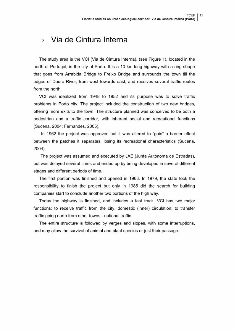
2. Via de Cintura Interna
The study area is the VCI (Via de Cintura Interna), (see Figure 1), located in the
north of Portugal, in the city of Porto. It is a 10 km long highway with a ring shape
that goes from Arrabida Bridge to Freixo Bridge and surrounds the town till the
edges of Douro River, from west towards east, and receives several traffic routes
from the north.
VCI was idealized from 1948 to 1952 and its purpose was to solve traffic
problems in Porto city. The project included the construction of two new bridges,
offering more exits to the town. The structure planned was conceived to be both a
pedestrian and a traffic corridor, with inherent social and recreational functions
(Sucena, 2004; Fernandes, 2005).
In 1962 the project was approved but it was altered to “gain” a barrier effect
between the patches it separates, losing its recreational characteristics (Sucena,
2004).
The project was assumed and executed by JAE (Junta Autónoma de Estradas),
but was delayed several times and ended up by being developed in several different
stages and different periods of time.
The first portion was finished and opened in 1963. In 1979, the state took the
responsibility to finish the project but only in 1985 did the search for building
companies start to conclude another two portions of the high way.
Today the highway is finished, and includes a fast track. VCI has two major
functions: to receive traffic from the city, domestic (inner) circulation; to transfer
traffic going north from other towns - national traffic.
The entire structure is followed by verges and slopes, with some interruptions,
and may allow the survival of animal and plant species or just their passage.
FCUP Floristic studies on urban ecological corridor: Via de Cintura Interna (Porto)
12
Figure 1: Map of VCI. Picture taken from the Google Earth. The VCI highway is represented in dark yellow. The surveyed points are indicated by the yellow drawing-pins.
3. Objectives of the work
The main objectives of this work are centred in the answers to the following
questions:
1. Is VCI (Via de Cintura Interna), an artificial corridor composed mainly of
slopes with vegetation and surrounding an inner ring road in Porto, in fact a
greenway?
2. Which plant species inhabit that corridor and how does plant diversity vary
along the structure?
3. Is there some sort of vegetation gradient established when it comes to the
proximity to the sea and to the river?
4. Can the corridor act as potential “freeway” for invasive plants?
5. Is vegetation composition influenced by the surrounding areas, e.g.,
agricultural fields versus residential blocks and other impermeable areas?
6. Can VCI be valued as an amenity-recreation venue, wildlife refuge and an
essential liveable-city ingredient?
7. How have ecological goals been set out to influence the planning, design
and management processes? Is there any evidence that these goals have
effectively influenced the planning processes within the study area?
FCUP Floristic studies on urban ecological corridor: Via de Cintura Interna (Porto)
13
4. Methodology
The development of this work involved an intensive bibliographic research so as
to better define the concepts of ecological corridor, greenway and others.
At the same time there was a need to study the vegetation growing in the corridor
composed by road embankments that surround the highway, VCI, in Porto.
Fieldwork was carried away during winter and spring campaigns.
Fifty study points were chosen along the two sides of the highway (see Figure 1).
The number of points was defined taking into account the length of VCI, so the data
collected would be representative.
In each point a floristic survey was carried away along a 10-meter transept
(whenever possible). Also several parameters (see table 1) were measured or
surveyed in situ or with the help of a GIS programme. Those parameters were
analysed with only some simple statistical methods since the floristic survey did not
allow procedures to be made deeper.
Characteristics associated to the greenway were surveyed to determine if the VCI
was in fact a greenway.
Vegetation was analysed to identify the presence of exotic species that may
interfere with the native species present and with the good function of the greenway.
The movement in the corridor of the highway was determined by the analysis of
the dispersal of the plants species along the structure.
To determine the relation between the vegetation and the proximity of the
river/sea it was compared the data collected in the several points and the distance
from that point to the river/sea; the relation between the vegetation present in the
corridor and the distance to the near green space was also determined.
Finally, the surrounding area was studied to determine its influence over the
corridor.
FCUP Floristic studies on urban ecological corridor: Via de Cintura Interna (Porto)
14
5. Results
In the survey it was possible to determine the variables present in Table 1. The
entire highway embankments, on both sides, are turned inwards to the highway and
have slopes that vary from 0% to 75.38%. The orientation followed by highway goes
from south-west to west on one side of the embankments while on the other it goes
from northeast to east.
The smallest embankment measured 1m width and the largest 100m. In the
largest the survey only considered the first 10m mark. The signal + before the 10m
in Table 1 means that the corridor is more them 10m width.
Sun exposure is constant in 78% of the points analysed, the other 22% of the
points have some shade during part of the day, mostly given by the buildings or
trees that surround them.
Some of the corridors that follow the highway had previous uses in the matrix that
surrounds them. One of the uses found is “private garden”; point 2 is associated to
Porto’s botanical garden; points 41, 42 and 44 are made of concrete because two
subway stations and train station respectively were build on them. The other points
are simple embankments of the highway without any apparent use.
“Estradas de Portugal” and Brisa are responsible for the maintenance of the
highway and its embankments, what happens around twice a year (although it was
possible to observe a more or less erratic behaviour of these operations), while the
private gardens have a more frequent management provided by their owners. The
information present in Table 1 refers to the periods the surveys were undertaken.
Under the Portuguese law it is forbidden to walk in a highway, so from the
highway it is impossible to access the embankments that follow VCI. The data
collected refers to the accessible side of the embankment, as shown in table1.
Fifty per cent of the points under study are not of public access, as an example point
47 is a closed private garden. Fourteen percent of those points were easily
accessible, such as point 7 that is a private garden open to community and 36% of
those points were not easily accessible, like point 21 that is a fenced private garden.
Fencing is a right that private owners have to protect their property but in this
case it may difficult the pedestrian access to the highway corridors. Forty six percent
(46%) of the embankments had fences that didn’t allow the access, mostly private
properties. Another 46% were non-fenced embankments associated with road
corridors, for example point 38 which was a roundabout. There were also semi-
fenced areas (only 8%), some of those areas have a fence in the middle of the
FCUP Floristic studies on urban ecological corridor: Via de Cintura Interna (Porto)
15
embankment while others, as result of vandalism, don’t have any barrier and the
fence hadn’t been replaced yet.
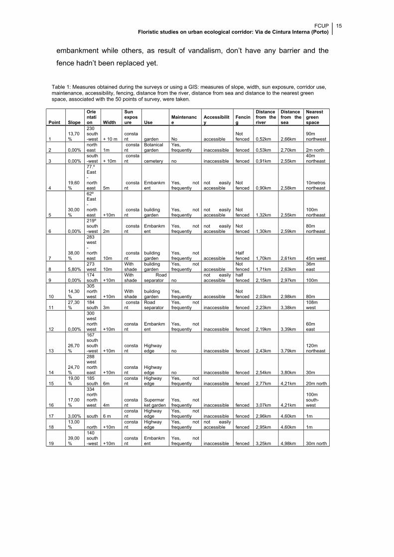
Table 1: Measures obtained during the surveys or using a GIS: measures of slope, width, sun exposure, corridor use, maintenance, accessibility, fencing, distance from the river, distance from sea and distance to the nearest green space, associated with the 50 points of survey, were taken.
Point Slope
Orientation Width
Sunexposure Use
Maintenance
Accessibility
Fencing
Distancefrom theriver
Distancefrom thesea
Nearestgreenspace
113,70%
230south-west + 10 m
constant garden No accessible
Notfenced 0,52km 2,66km
90mnorthwest
2 0,00%northeast 1m
constant
Botanicalgarden
Yes,frequently inaccessible fenced 0,53km 2,70km 2m north
3 0,00%south-west + 10m
constant cemetery no inaccessible fenced 0,91km 2,55km
40mnortheast
419,60%
77.ºEast-northeast 5m
constant
Embankment
Yes, notfrequently
not easilyaccessible
Notfenced 0,90km 2,58km
10metrosnortheast
530,00%
62ºEast-northeast +10m
constant
buildinggarden
Yes, notfrequently
not easilyaccessible
Notfenced 1,32km 2,55km
100mnortheast
6 0,00%
219ºsouth-west 2m
constant
Embankment
Yes, notfrequently
not easilyaccessible
Notfenced 1,30km 2,59km
80mnortheast
738,00%
283west-northeast 10m
constant
buildinggarden
Yes, notfrequently accessible
Halffenced 1,70km 2,61km 45m west
8 5,80%273west 10m
Withshade
buildinggarden
Yes, notfrequently accessible
Notfenced 1,71km 2,63km
36m east
9 0,00%174south +10m
Withshade
Roadseparator no
not easilyaccessible
halffenced 2,15km 2,97km 100m
1014,30%
305northwest +10m
Withshade
buildinggarden
Yes,frequently accessible
Notfenced 2,03km 2,98km 80m
1127,30%
184south 3m
constant
Roadseparator
Yes, notfrequently inaccessible fenced 2,23km 3,38km
108mwest
12 0,00%
300westnorthwest +10m
constant
Embankment
Yes, notfrequently inaccessible fenced 2,19km 3,39km
60m east
1326,70%
167southsouth-west +10m
constant
Highwayedge no inaccessible fenced 2,43km 3,79km
120mnortheast
1424,70%
288westnortheast +10m
constant
Highwayedge no inaccessible fenced 2,54km 3,80km 30m
1519,00%
185south 6m
constant
Highwayedge
Yes, notfrequently inaccessible fenced 2,77km 4,21km 20m north
1617,00%
334northnorthwest 4m
constant
Supermarket garden
Yes, notfrequently inaccessible fenced 3,07km 4,21km
100msouth-west
17 3,00% south 6 mconstant
Highwayedge
Yes, notfrequently inaccessible fenced 2,96km 4,60km 1m
1813,00% north +10m
constant
Highwayedge
Yes, notfrequently
not easilyaccessible fenced 2,95km 4,60km 1m
1939,00%
140south-west +10m
constant
Embankment
Yes, notfrequently inaccessible fenced 3,25km 4,98km 30m north
FCUP Floristic studies on urban ecological corridor: Via de Cintura Interna (Porto)
16
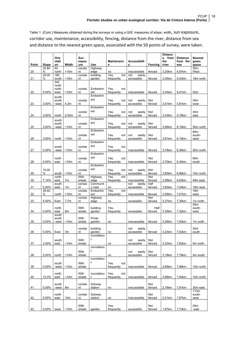
Table 1: (Cont.) Measures obtained during the surveys or using a GIS: measures of slope, width, sun exposure, corridor use, maintenance, accessibility, fencing, distance from the river, distance from sea and distance to the nearest green space, associated with the 50 points of survey, were taken.
Point Slope
Orientation Width
Sunexposure Use
Maintenance
Accessibility Fencing
Distance fromtheriver
Distancefrom thesea
Nearestgreenspace
2025,80%
60north +10m
constant
Highwayedge no inaccessible fenced 3,20km 4,97km
50m West
2124,00%
180south +10m
constant
buildinggarden
Yes, notfrequently
not easilyaccessible fenced 3,35km 5,43km 18m north
22 0,00%
342northnorthwest +10m
constant
Embankment
Yes, notfrequently inaccessible fenced 3,34km 5,41km 50m
23 3,00%
southsouth-west 4,3m
constant
Embankment Yes, not
frequentlynot easilyaccessible
Notfenced 3,51km 5,81km
25m west
24 3,00% north 2,45mconstant
Embankment Yes, not
frequentlynot easilyaccessible
Notfenced 3,43km 5,78km
40m east
25 3,00%
southsouth-west +10m
constant
Embankment Yes, not
frequentlynot easilyaccessible
Notfenced 3,88km 6,18km 50m north
26 3,00% north +10mconstant
Embankment Yes, not
frequentlynot easilyaccessible
Notfenced 3,81km 6,14km
60msouth-west
27 0,00%south-west +10m
constant
Embankment Yes, not
frequently inaccessible fenced 3,78km 6,39km 50m north
28 0,00%northeast +10m
constant
Embankment Yes, not
frequently inaccessibleNotfenced 3,70km 6,34km
60msouth
2910,00% south +10m
constant
Embankment Yes, not
frequentlynot easilyaccessible
Notfenced 3,65km 6,66km 70m north
30 7,14%northeast 7m
Withshade
Highwayedge
Yes, notfrequently inaccessible
Notfenced 3,58km 6,63km 49m east
31 0,00%southeast 1m
constant
Community road no
not easilyaccessible
halffenced 3,65km 7,04km 18m west
3229,40% north +10m
constant
Embankment
Yes, notfrequently inaccessible fenced 3,59km 7,01km
18m west
33 5,00% East 7,7mconstant
Highwayedge no accessible
Notfenced 3,37km 7,35km 1m north
34 0,00%northeast 8m
Withshade
buildinggarden
Yes,frequently accessible
Halffenced 3,35km 7,32km
20msouth-west
35 0,00%
southsouth-west +10m
Withshade
Privetgarden no inaccessible fenced 3,26km 7,55km 1m north
36 0,00% East 3mconstant
buildinggarden no
not easilyaccessible fenced 3,23km 7,52km
20msouth
37 2,00%southeast +10m
Withshade
roundabout
nonot easilyaccessible
Notfenced 3,22km 7,82km 5m north
38 2,00% north +10mWithshade
roundabout
nonot easilyaccessible
Notfenced 3,18km 7,78km 5m south
39 0,00%south-west +10m
Withshade
roundabout Yes, not
frequently inaccessible fenced 2,89km 7,98km 10m north
40 13,3%northeast +10m
Withshade
roundabout
Yes, notfrequently inaccessible fenced 2,88km 7,94km 15m north
41 0,00%south-west 8m
constant
Subwaystation no inaccessible
Notfenced 2,18km 7,91km 30m east
42 0,00%northeast 10m
constant
Subwaystation no inaccessible
Notfenced 2,21km 7,87km
113msouth-west
43 0,00% west +10mWithshade garden
Yes,frequently accessible
Notfenced 1,87km 7,73km
25m east
FCUP Floristic studies on urban ecological corridor: Via de Cintura Interna (Porto)
17
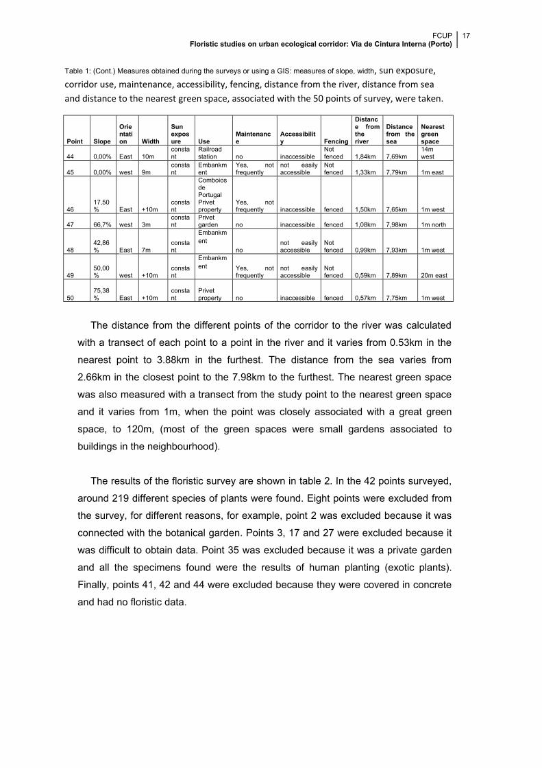
Table 1: (Cont.) Measures obtained during the surveys or using a GIS: measures of slope, width, sun exposure, corridor use, maintenance, accessibility, fencing, distance from the river, distance from sea and distance to the nearest green space, associated with the 50 points of survey, were taken.
Point Slope
Orientation Width
Sunexposure Use
Maintenance
Accessibility Fencing
Distance fromtheriver
Distancefrom thesea
Nearestgreenspace
44 0,00% East 10mconstant
Railroadstation no inaccessible
Notfenced 1,84km 7,69km
14m west
45 0,00% west 9mconstant
Embankment
Yes, notfrequently
not easilyaccessible
Notfenced 1,33km 7,79km 1m east
4617,50% East +10m
constant
ComboiosdePortugalPrivetproperty
Yes, notfrequently inaccessible fenced 1,50km 7,65km 1m west
47 66,7% west 3mconstant
Privetgarden no inaccessible fenced 1,08km 7,98km 1m north
4842,86% East 7m
constant
Embankment
nonot easilyaccessible
Notfenced 0,99km 7,93km 1m west
4950,00% west +10m
constant
Embankment Yes, not
frequentlynot easilyaccessible
Notfenced 0,59km 7,89km 20m east
5075,38% East +10m
constant
Privetproperty no inaccessible fenced 0,57km 7,75km 1m west
The distance from the different points of the corridor to the river was calculated
with a transect of each point to a point in the river and it varies from 0.53km in the
nearest point to 3.88km in the furthest. The distance from the sea varies from
2.66km in the closest point to the 7.98km to the furthest. The nearest green space
was also measured with a transect from the study point to the nearest green space
and it varies from 1m, when the point was closely associated with a great green
space, to 120m, (most of the green spaces were small gardens associated to
buildings in the neighbourhood).
The results of the floristic survey are shown in table 2. In the 42 points surveyed,
around 219 different species of plants were found. Eight points were excluded from
the survey, for different reasons, for example, point 2 was excluded because it was
connected with the botanical garden. Points 3, 17 and 27 were excluded because it
was difficult to obtain data. Point 35 was excluded because it was a private garden
and all the specimens found were the results of human planting (exotic plants).
Finally, points 41, 42 and 44 were excluded because they were covered in concrete
and had no floristic data.
FCUP Floristic studies on urban ecological corridor: Via de Cintura Interna (Porto)
18
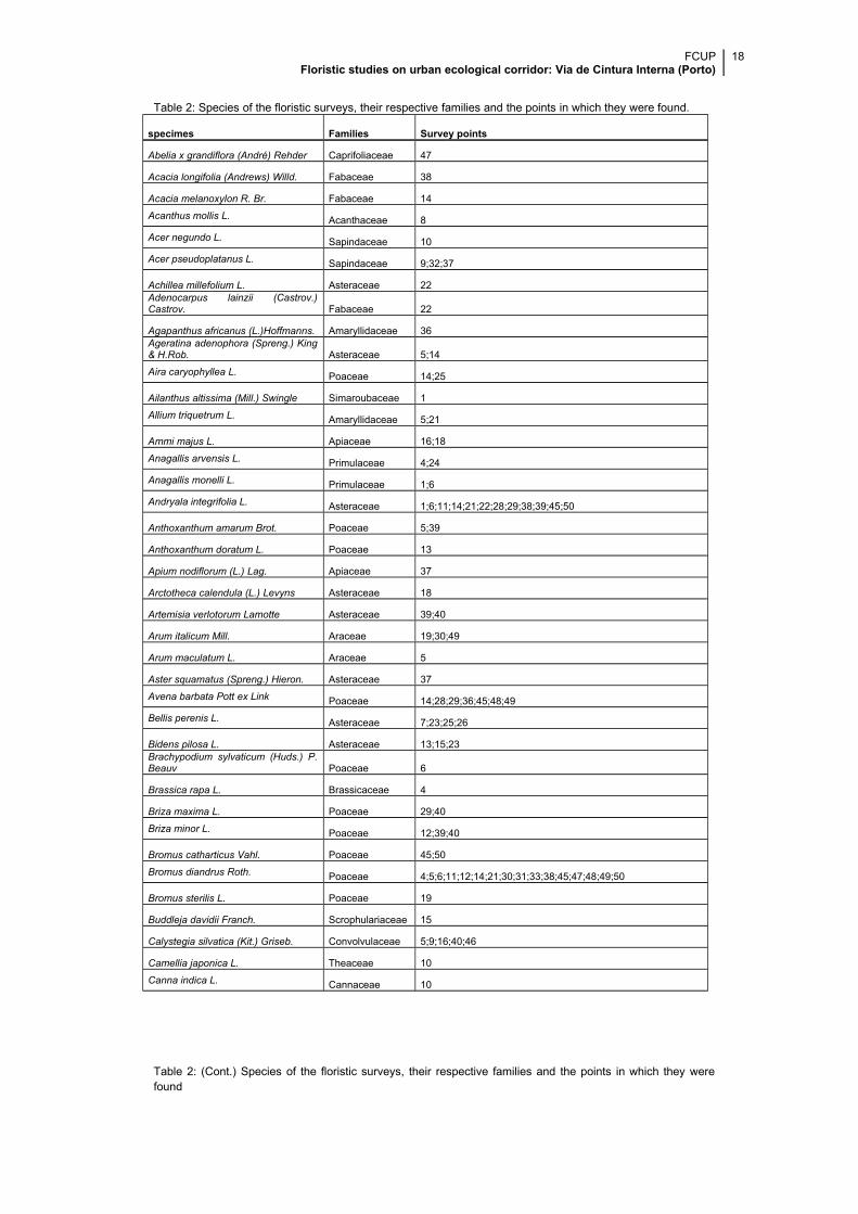
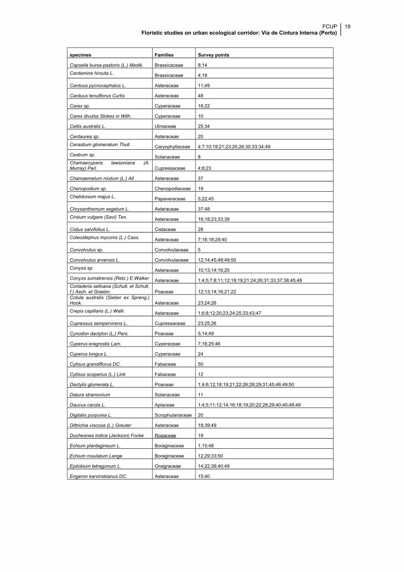
Table 2: Species of the floristic surveys, their respective families and the points in which they were found.
specimes Families Survey points
Abelia x grandiflora (André) Rehder Caprifoliaceae 47
Acacia longifolia (Andrews) Willd. Fabaceae 38
Acacia melanoxylon R. Br. Fabaceae 14
Acanthus mollis L. Acanthaceae 8
Acer negundo L. Sapindaceae 10
Acer pseudoplatanus L. Sapindaceae 9;32;37
Achillea millefolium L. Asteraceae 22Adenocarpus lainzii (Castrov.)Castrov. Fabaceae 22
Agapanthus africanus (L.)Hoffmanns. Amaryllidaceae 36Ageratina adenophora (Spreng.) King& H.Rob. Asteraceae 5;14
Aira caryophyllea L. Poaceae 14;25
Ailanthus altissima (Mill.) Swingle Simaroubaceae 1
Allium triquetrum L. Amaryllidaceae 5;21
Ammi majus L. Apiaceae 16;18
Anagallis arvensis L. Primulaceae 4;24
Anagallis monelli L. Primulaceae 1;6
Andryala integrifolia L. Asteraceae 1;6;11;14;21;22;28;29;38;39;45;50
Anthoxanthum amarum Brot. Poaceae 5;39
Anthoxanthum doratum L. Poaceae 13
Apium nodiflorum (L.) Lag. Apiaceae 37
Arctotheca calendula (L.) Levyns Asteraceae 18
Artemisia verlotorum Lamotte Asteraceae 39;40
Arum italicum Mill. Araceae 19;30;49
Arum maculatum L. Araceae 5
Aster squamatus (Spreng.) Hieron. Asteraceae 37
Avena barbata Pott ex Link Poaceae 14;28;29;36;45;48;49
Bellis perenis L. Asteraceae 7;23;25;26
Bidens pilosa L. Asteraceae 13;15;23Brachypodium sylvaticum (Huds.) P.Beauv Poaceae 6
Brassica rapa L. Brassicaceae 4
Briza maxima L. Poaceae 29;40
Briza minor L. Poaceae 12;39;40
Bromus catharticus Vahl. Poaceae 45;50
Bromus diandrus Roth. Poaceae 4;5;6;11;12;14;21;30;31;33;38;45;47;48;49;50
Bromus sterilis L. Poaceae 19
Buddleja davidii Franch. Scrophulariaceae 15
Calystegia silvatica (Kit.) Griseb. Convolvulaceae 5;9;16;40;46
Camellia japonica L. Theaceae 10
Canna indica L. Cannaceae 10
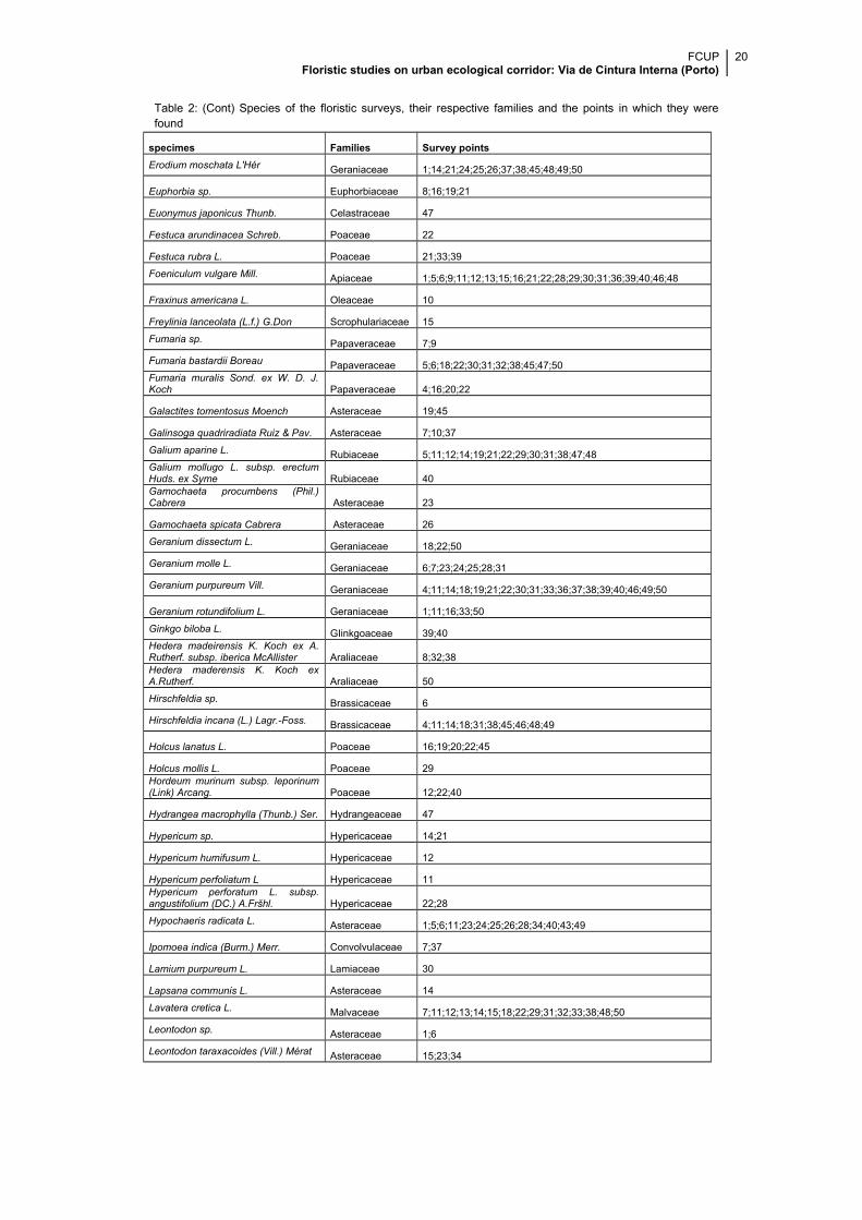
Table 2: (Cont.) Species of the floristic surveys, their respective families and the points in which they werefound
FCUP Floristic studies on urban ecological corridor: Via de Cintura Interna (Porto)
19
specimes Families Survey points
Capsella bursa-pastoris (L.) Medik. Brassicaceae 8;14
Cardamine hirsuta L. Brassicaceae 4;19
Carduus pycnocephalus L. Asteraceae 11;49
Carduus tenuiflorus Curtis Asteraceae 48
Carex sp. Cyperaceae 16;22
Carex divulsa Stokes in With. Cyperaceae 10
Celtis australis L. Ulmaceae 25;34
Centaurea sp. Asteraceae 20
Cerastium glomeratum Thull. Caryophyllaceae 4;7;10;19;21;23;25;26;30;33;34;49
Cestrum sp. Solanaceae 8Chamaecyparis lawsoniana (A.Murray) Parl. Cupressaceae 4;8;23
Chamaemelum mixtum (L.) All Asteraceae 37
Chenopodium sp. Chenopodiaceae 19
Chelidonium majus L. Papaveraceae 5;22;45
Chrysanthemum segetum L. Asteraceae 37;48
Cirsium vulgare (Savi) Ten. Asteraceae 16;18;23;33;39
Cistus salvifolius L. Cistaceae 28
Coleostephus myconis (L.) Cass. Asteraceae 7;16;18;29;40
Convolvulus sp. Convolvulaceae 5
Convolvulus arvensis L. Convolvulaceae 12;14;45;48;49;50
Conyza sp. Asteraceae 10;13;14;16;20
Conyza sumatrensis (Retz.) E.Walker Asteraceae 1;4;5;7;8;11;12;18;19;21;24;26;31;33;37;38;45;48Cortaderia selloana (Schult. et Schult.f.) Asch. et Graebn. Poaceae 12;13;14;16;21;22Cotula australis (Sieber ex Spreng.)Hook. Asteraceae 23;24;26
Crepis capillaris (L.) Wallr. Asteraceae 1;6;8;12;20;23;24;25;33;43;47
Cupressus sempervirens L. Cupressaceae 23;25;26
Cynodon dactylon (L.) Pers. Poaceae 5;14;49
Cyperus eragrostis Lam. Cyperaceae 7;16;25;46
Cyperus longus L. Cyperaceae 24
Cytisus grandiflorus DC. Fabaceae 50
Cytisus scoparius (L.) Link Fabaceae 12
Dactylis glomerata L. Poaceae 1;4;6;12;18;19;21;22;26;28;29;31;45;46;49;50
Datura stramonium Solanaceae 11
Daucus carota L. Apiaceae 1;4;5;11;12;14;16;18;19;20;22;28;29;40;45;48;49
Digitalis purpurea L. Scrophulariaceae 20
Dittrichia viscosa (L.) Greuter Asteraceae 18;39;49
Duchesnea indica (Jackson) Focke Rosaceae 19
Echium plantagineum L. Boraginaceae 1;15;48
Echium rosulatum Lange Boraginaceae 12;29;33;50
Epilobium tetragonum L. Onagraceae 14;22;39;40;49
Erigeron karvinskianus DC. Asteraceae 15;40
FCUP Floristic studies on urban ecological corridor: Via de Cintura Interna (Porto)
20
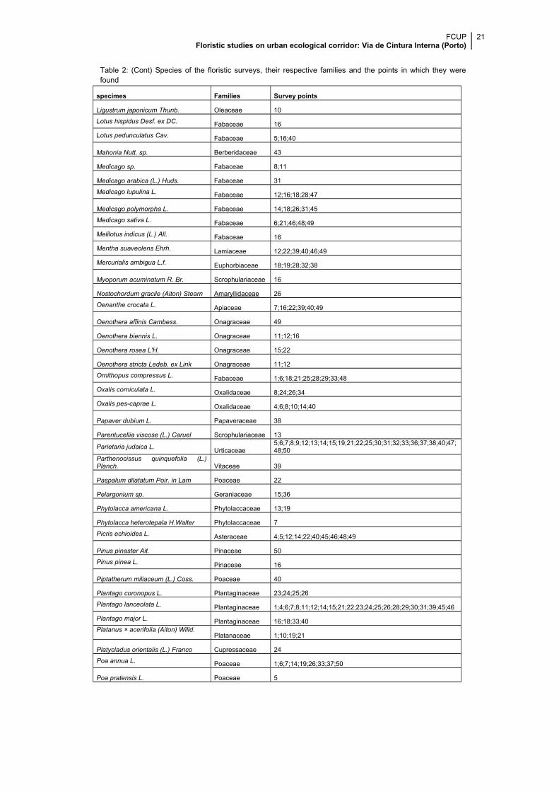
Table 2: (Cont) Species of the floristic surveys, their respective families and the points in which they werefound
specimes Families Survey points
Erodium moschata L'Hér Geraniaceae 1;14;21;24;25;26;37;38;45;48;49;50
Euphorbia sp. Euphorbiaceae 8;16;19;21
Euonymus japonicus Thunb. Celastraceae 47
Festuca arundinacea Schreb. Poaceae 22
Festuca rubra L. Poaceae 21;33;39
Foeniculum vulgare Mill. Apiaceae 1;5;6;9;11;12;13;15;16;21;22;28;29;30;31;36;39;40;46;48
Fraxinus americana L. Oleaceae 10
Freylinia lanceolata (L.f.) G.Don Scrophulariaceae 15
Fumaria sp. Papaveraceae 7;9
Fumaria bastardii Boreau Papaveraceae 5;6;18;22;30;31;32;38;45;47;50Fumaria muralis Sond. ex W. D. J.Koch Papaveraceae 4;16;20;22
Galactites tomentosus Moench Asteraceae 19;45
Galinsoga quadriradiata Ruiz & Pav. Asteraceae 7;10;37
Galium aparine L. Rubiaceae 5;11;12;14;19;21;22;29;30;31;38;47;48Galium mollugo L. subsp. erectumHuds. ex Syme Rubiaceae 40Gamochaeta procumbens (Phil.)Cabrera Asteraceae 23
Gamochaeta spicata Cabrera Asteraceae 26
Geranium dissectum L. Geraniaceae 18;22;50
Geranium molle L. Geraniaceae 6;7;23;24;25;28;31
Geranium purpureum Vill. Geraniaceae 4;11;14;18;19;21;22;30;31;33;36;37;38;39;40;46;49;50
Geranium rotundifolium L. Geraniaceae 1;11;16;33;50
Ginkgo biloba L. GIinkgoaceae 39;40Hedera madeirensis K. Koch ex A.Rutherf. subsp. iberica McAllister Araliaceae 8;32;38Hedera maderensis K. Koch exA.Rutherf. Araliaceae 50
Hirschfeldia sp. Brassicaceae 6
Hirschfeldia incana (L.) Lagr.-Foss. Brassicaceae 4;11;14;18;31;38;45;46;48;49
Holcus lanatus L. Poaceae 16;19;20;22;45
Holcus mollis L. Poaceae 29Hordeum murinum subsp. leporinum(Link) Arcang. Poaceae 12;22;40
Hydrangea macrophylla (Thunb.) Ser. Hydrangeaceae 47
Hypericum sp. Hypericaceae 14;21
Hypericum humifusum L. Hypericaceae 12
Hypericum perfoliatum L Hypericaceae 11Hypericum perforatum L. subsp.angustifolium (DC.) A.Fršhl. Hypericaceae 22;28
Hypochaeris radicata L. Asteraceae 1;5;6;11;23;24;25;26;28;34;40;43;49
Ipomoea indica (Burm.) Merr. Convolvulaceae 7;37
Lamium purpureum L. Lamiaceae 30
Lapsana communis L. Asteraceae 14
Lavatera cretica L. Malvaceae 7;11;12;13;14;15;18;22;29;31;32;33;38;48;50
Leontodon sp. Asteraceae 1;6
Leontodon taraxacoides (Vill.) Mérat Asteraceae 15;23;34
FCUP Floristic studies on urban ecological corridor: Via de Cintura Interna (Porto)
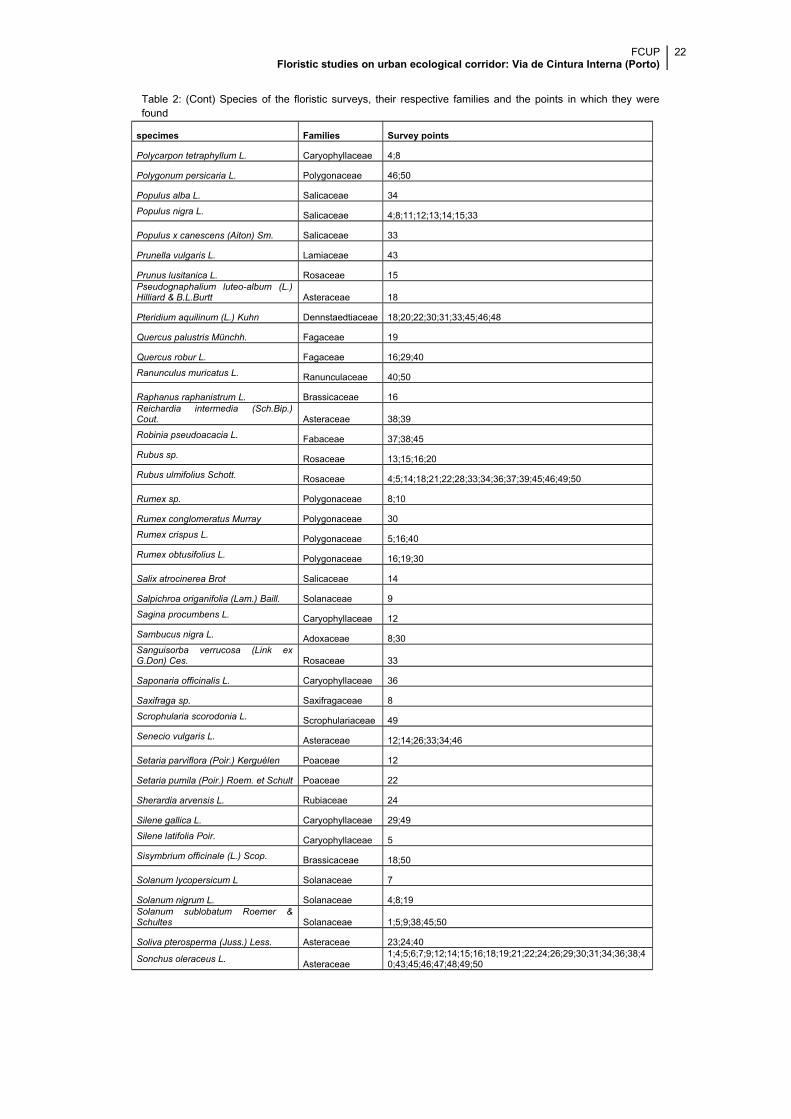
21
Table 2: (Cont) Species of the floristic surveys, their respective families and the points in which they werefound
specimes Families Survey points
Ligustrum japonicum Thunb. Oleaceae 10
Lotus hispidus Desf. ex DC. Fabaceae 16
Lotus pedunculatus Cav. Fabaceae 5;16;40
Mahonia Nutt. sp. Berberidaceae 43
Medicago sp. Fabaceae 8;11
Medicago arabica (L.) Huds. Fabaceae 31
Medicago lupulina L. Fabaceae 12;16;18;28;47
Medicago polymorpha L. Fabaceae 14;18;26;31;45
Medicago sativa L. Fabaceae 6;21;46;48;49
Melilotus indicus (L.) All. Fabaceae 16
Mentha suaveolens Ehrh. Lamiaceae 12;22;39;40;46;49
Mercurialis ambigua L.f. Euphorbiaceae 18;19;28;32;38
Myoporum acuminatum R. Br. Scrophulariaceae 16
Nostochordum gracile (Aiton) Stearn Amaryllidaceae 26
Oenanthe crocata L. Apiaceae 7;16;22;39;40;49
Oenothera affinis Cambess. Onagraceae 49
Oenothera biennis L. Onagraceae 11;12;16
Oenothera rosea L'H. Onagraceae 15;22
Oenothera stricta Ledeb. ex Link Onagraceae 11;12
Ornithopus compressus L. Fabaceae 1;6;18;21;25;28;29;33;48
Oxalis corniculata L. Oxalidaceae 8;24;26;34
Oxalis pes-caprae L. Oxalidaceae 4;6;8;10;14;40
Papaver dubium L. Papaveraceae 38
Parentucellia viscose (L.) Caruel Scrophulariaceae 13
Parietaria judaica L.Urticaceae
5;6;7;8;9;12;13;14;15;19;21;22;25;30;31;32;33;36;37;38;40;47;48;50
Parthenocissus quinquefolia (L.)Planch. Vitaceae 39
Paspalum dilatatum Poir. in Lam Poaceae 22
Pelargonium sp. Geraniaceae 15;36
Phytolacca americana L. Phytolaccaceae 13;19
Phytolacca heterotepala H.Walter Phytolaccaceae 7
Picris echioides L. Asteraceae 4;5;12;14;22;40;45;46;48;49
Pinus pinaster Ait. Pinaceae 50
Pinus pinea L. Pinaceae 16
Piptatherum miliaceum (L.) Coss. Poaceae 40
Plantago coronopus L. Plantaginaceae 23;24;25;26
Plantago lanceolata L. Plantaginaceae 1;4;6;7;8;11;12;14;15;21;22;23;24;25;26;28;29;30;31;39;45;46
Plantago major L. Plantaginaceae 16;18;33;40Platanus × acerifolia (Aiton) Willd.
Platanaceae 1;10;19;21
Platycladus orientalis (L.) Franco Cupressaceae 24
Poa annua L. Poaceae 1;6;7;14;19;26;33;37;50
Poa pratensis L. Poaceae 5
FCUP Floristic studies on urban ecological corridor: Via de Cintura Interna (Porto)
22
Table 2: (Cont) Species of the floristic surveys, their respective families and the points in which they werefound
specimes Families Survey points
Polycarpon tetraphyllum L. Caryophyllaceae 4;8
Polygonum persicaria L. Polygonaceae 46;50
Populus alba L. Salicaceae 34
Populus nigra L. Salicaceae 4;8;11;12;13;14;15;33
Populus x canescens (Aiton) Sm. Salicaceae 33
Prunella vulgaris L. Lamiaceae 43
Prunus lusitanica L. Rosaceae 15Pseudognaphalium luteo-album (L.)Hilliard & B.L.Burtt Asteraceae 18
Pteridium aquilinum (L.) Kuhn Dennstaedtiaceae 18;20;22;30;31;33;45;46;48
Quercus palustris Münchh. Fagaceae 19
Quercus robur L. Fagaceae 16;29;40
Ranunculus muricatus L. Ranunculaceae 40;50
Raphanus raphanistrum L. Brassicaceae 16Reichardia intermedia (Sch.Bip.)Cout. Asteraceae 38;39
Robinia pseudoacacia L. Fabaceae 37;38;45
Rubus sp. Rosaceae 13;15;16;20
Rubus ulmifolius Schott. Rosaceae 4;5;14;18;21;22;28;33;34;36;37;39;45;46;49;50
Rumex sp. Polygonaceae 8;10
Rumex conglomeratus Murray Polygonaceae 30
Rumex crispus L. Polygonaceae 5;16;40
Rumex obtusifolius L. Polygonaceae 16;19;30
Salix atrocinerea Brot Salicaceae 14
Salpichroa origanifolia (Lam.) Baill. Solanaceae 9
Sagina procumbens L. Caryophyllaceae 12
Sambucus nigra L. Adoxaceae 8;30Sanguisorba verrucosa (Link exG.Don) Ces. Rosaceae 33
Saponaria officinalis L. Caryophyllaceae 36
Saxifraga sp. Saxifragaceae 8
Scrophularia scorodonia L. Scrophulariaceae 49
Senecio vulgaris L. Asteraceae 12;14;26;33;34;46
Setaria parviflora (Poir.) Kerguélen Poaceae 12
Setaria pumila (Poir.) Roem. et Schult Poaceae 22
Sherardia arvensis L. Rubiaceae 24
Silene gallica L. Caryophyllaceae 29;49
Silene latifolia Poir. Caryophyllaceae 5
Sisymbrium officinale (L.) Scop. Brassicaceae 18;50
Solanum lycopersicum L Solanaceae 7
Solanum nigrum L. Solanaceae 4;8;19Solanum sublobatum Roemer &Schultes Solanaceae 1;5;9;38;45;50
Soliva pterosperma (Juss.) Less. Asteraceae 23;24;40
Sonchus oleraceus L.Asteraceae
1;4;5;6;7;9;12;14;15;16;18;19;21;22;24;26;29;30;31;34;36;38;40;43;45;46;47;48;49;50
FCUP Floristic studies on urban ecological corridor: Via de Cintura Interna (Porto)
23
Table 2: (Cont) Species of the floristic surveys, their respective families and the points in which they werefound
specimes Families Survey points
Spergularia sp. Caryophyllaceae 8
Sporobolus indicus (L.) R.Br. Poaceae 43
Stellaria media (l.) Vill. Caryophyllaceae 9;24;30Stenotaphrum secundatum (Walt.)Kuntze Poaceae 47
Taraxacum sp. Asteraceae 1;8
Taraxacum ekmanii Dahlst. Asteraceae 19;25;50
Teucrium scorodonia L. Lamiaceae 28
Thuja plicata Donn ex D.Don Cupressaceae 4;6;8
Tilia americana L.Tiliaceae/Malvaceae 8;28
Tilia tomentosa MoenchTiliaceae/Malvaceae 30
Torilis arvensis (Huds.) Link Apiaceae 33;45;50
Tradescantia fluminensis Vell. Commelinaceae 8;34
Trifolium arvense L. Fabaceae 28
Trifolium campestre Schreb. Fabaceae 39;40;49
Trifolium dubium Sibth. Fabaceae 23;33;43
Trifolium pratense L. Fabaceae 4;5;7;11;12;16;18;22;39;40;48;49
Trifolium repens L. Fabaceae 1;6;8;11;16;18;19;20;22;23;26;28;33;37;43;50
Trifolium resupinatum L. Fabaceae 43
Trifolium subterraneum L. Fabaceae 1;25Ulex europaeus L. subsp.Latebracteatus (Mariz) Rothm. Fabaceae 1;11;12;14;39
Ulex minor Roth Fabaceae 20
Urtica dioica L Urticaceae 14
Urtica membranacea Poir. Urticaceae 7;8;30;47
Verbascum sp. Scrophulariaceae 13Verbascum simplex Hoffmanns. &Link Scrophulariaceae 48
Verbena bonariensis L. Verbenaceae 12;18
Verbena officinalis L. Verbenaceae 14;18;37
Veronica arvensis L. Scrophulariaceae 10;19;34
Veronica officinalis L. Plantaginaceae 18;26
Viburnum tinus L. Adoxaceae 34
Vicia disperma DC. Fabaceae 15;28
Vicia hirsuta (L.) Gray Fabaceae 18;29;30;38;39;49
Vicia sativa L. Fabaceae 14;15;22;33;36;38;39;40;49;50
Vitis vinifera L. Vitaceae 46
Vulpia myuros (L.) C.C. Gmel. Poaceae 6;25;26
x Cuprocyparis leylandii Cupressaceae 34
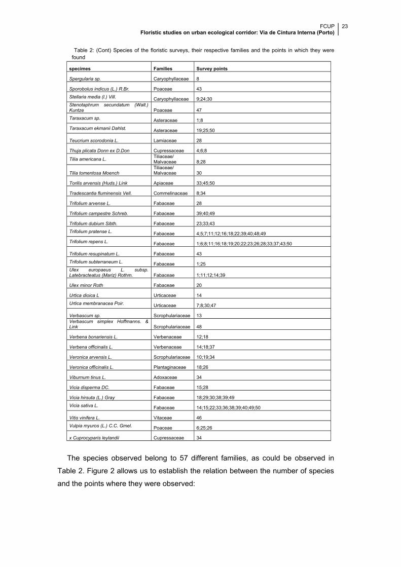
The species observed belong to 57 different families, as could be observed in
Table 2. Figure 2 allows us to establish the relation between the number of species
and the points where they were observed:
FCUP Floristic studies on urban ecological corridor: Via de Cintura Interna (Porto)
24
o The point with the most species observed is point 14, which has 35
different species;
o The point with the lowest number of species is point 32 with just 6
species.
Figure 2: Relation between number of species and the points where they were observed.
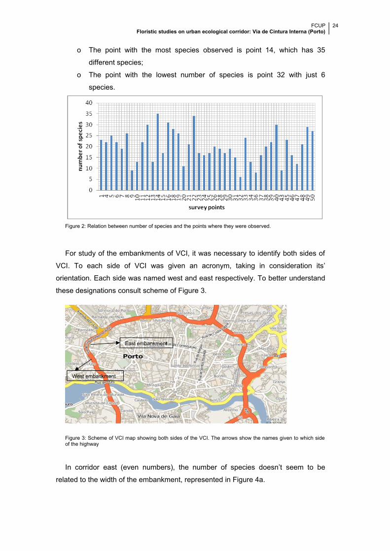
For study of the embankments of VCI, it was necessary to identify both sides of
VCI. To each side of VCI was given an acronym, taking in consideration its’
orientation. Each side was named west and east respectively. To better understand
these designations consult scheme of Figure 3.
Figure 3: Scheme of VCI map showing both sides of the VCI. The arrows show the names given to which sideof the highway
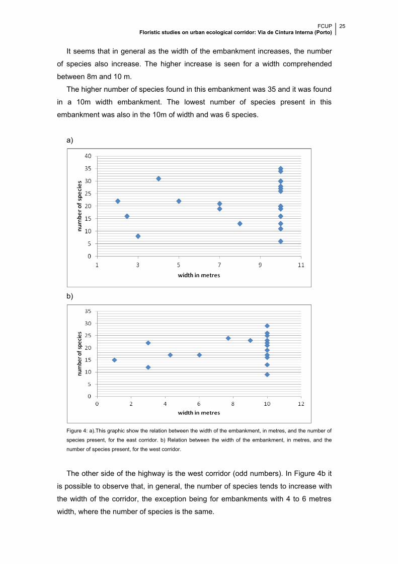
In corridor east (even numbers), the number of species doesn’t seem to be
related to the width of the embankment, represented in Figure 4a.
East embankment
West embankment
FCUP Floristic studies on urban ecological corridor: Via de Cintura Interna (Porto)
25
It seems that in general as the width of the embankment increases, the number
of species also increase. The higher increase is seen for a width comprehended
between 8m and 10 m.
The higher number of species found in this embankment was 35 and it was found
in a 10m width embankment. The lowest number of species present in this
embankment was also in the 10m of width and was 6 species.
a)
b)
Figure 4: a).This graphic show the relation between the width of the embankment, in metres, and the number of
species present, for the east corridor. b) Relation between the width of the embankment, in metres, and the
number of species present, for the west corridor.
The other side of the highway is the west corridor (odd numbers). In Figure 4b it
is possible to observe that, in general, the number of species tends to increase with
the width of the corridor, the exception being for embankments with 4 to 6 metres
width, where the number of species is the same.
FCUP Floristic studies on urban ecological corridor: Via de Cintura Interna (Porto)
26
The highest number of species found was 29 and they were observed in the 10m
width slopes. The lowest number of species found was also observed in the 10m
width ramps which had 9 species.
The 10m was a theoretical measure used to define a limit in the survey as said
before. In the two graphics above it is possible to observe that there isn’t a large
difference between the number of species found in embankments in the interval of 1
- 9m and the number of species found in a 10m width slope.
In both graphics the increase in the number of species, as the width of the
corridor increases, is very similar.
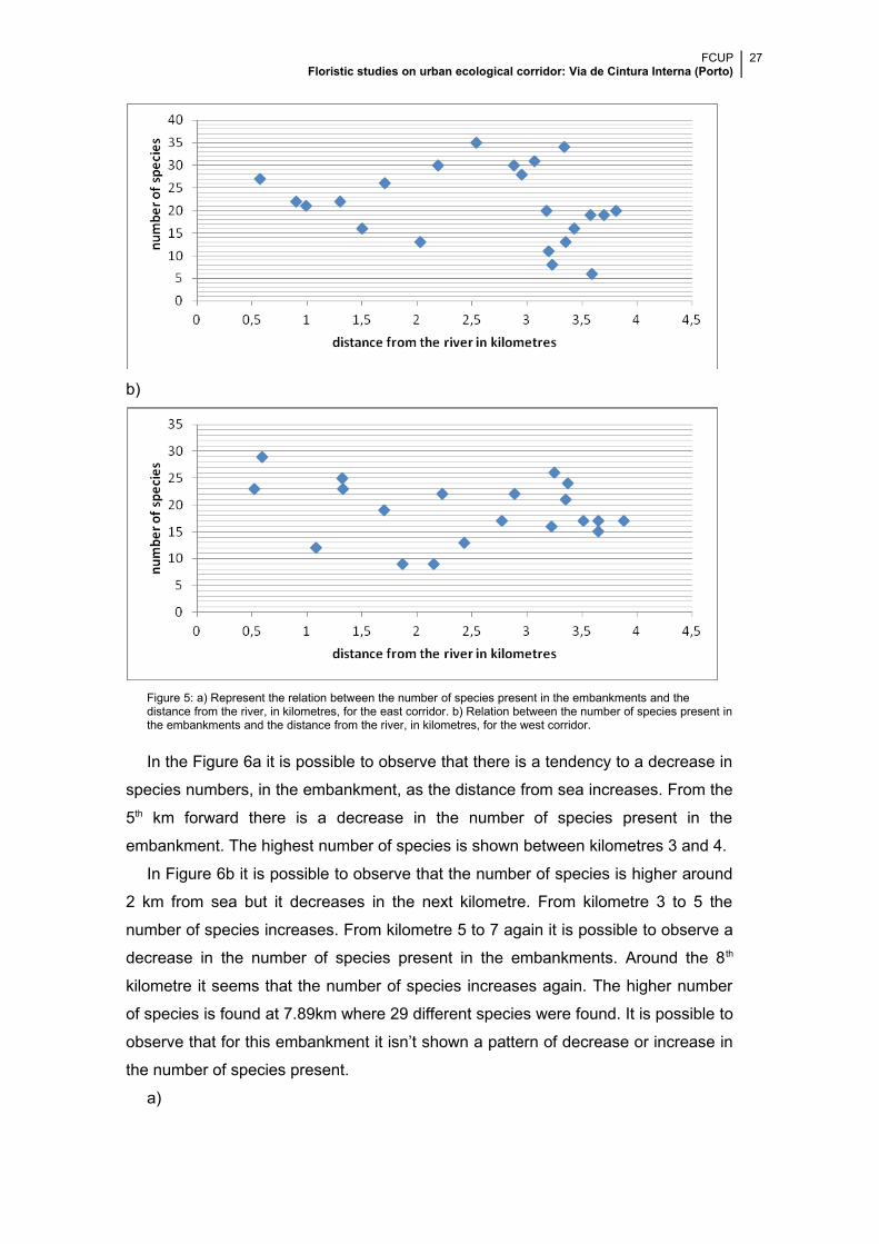
In Figure 5a it can be observed that up to 1km from the river (distance measured
from the sampled point, perpendicularly, to a spot on the river), the number of
species decreases. From 1km to around 2,6km the number of species rises. Moving
away from the river, the number of species oscillates, growing and diminishing,
reaching its maximum at 2,54 km away from the river. It is possible to observe 9
points presenting a lower number of species for higher distances away from the
river. The highest number of species in this embankment was 35 and was found 2.5
km away from the river. The lowest number of species was 6 and they were located
3.6km away from the river.
In Figure 5b it is possible to observe that is closer to the river that the higher the
number of species is observed. However this is an isolated case and do not
represent a tendency.
From 2km until around 3.5km from the river there is an increase in the number of
species (with some oscillations), and from there the number of species decreases
suddenly, after which remain stable.
The highest number of species is 29 at kilometre 0.59. The lowest number found
was 9 species around 2km from the river.
In both Figures (5a, 5b) it is observed a slight tendency to a decrease in the
number of species present in the embankments as distance increase to the river,
even though it is observe a higher number of species away from the river. This
decrease is more accentuated in Figure 5a.
a)
FCUP Floristic studies on urban ecological corridor: Via de Cintura Interna (Porto)
27
b)
Figure 5: a) Represent the relation between the number of species present in the embankments and the distance from the river, in kilometres, for the east corridor. b) Relation between the number of species present inthe embankments and the distance from the river, in kilometres, for the west corridor.
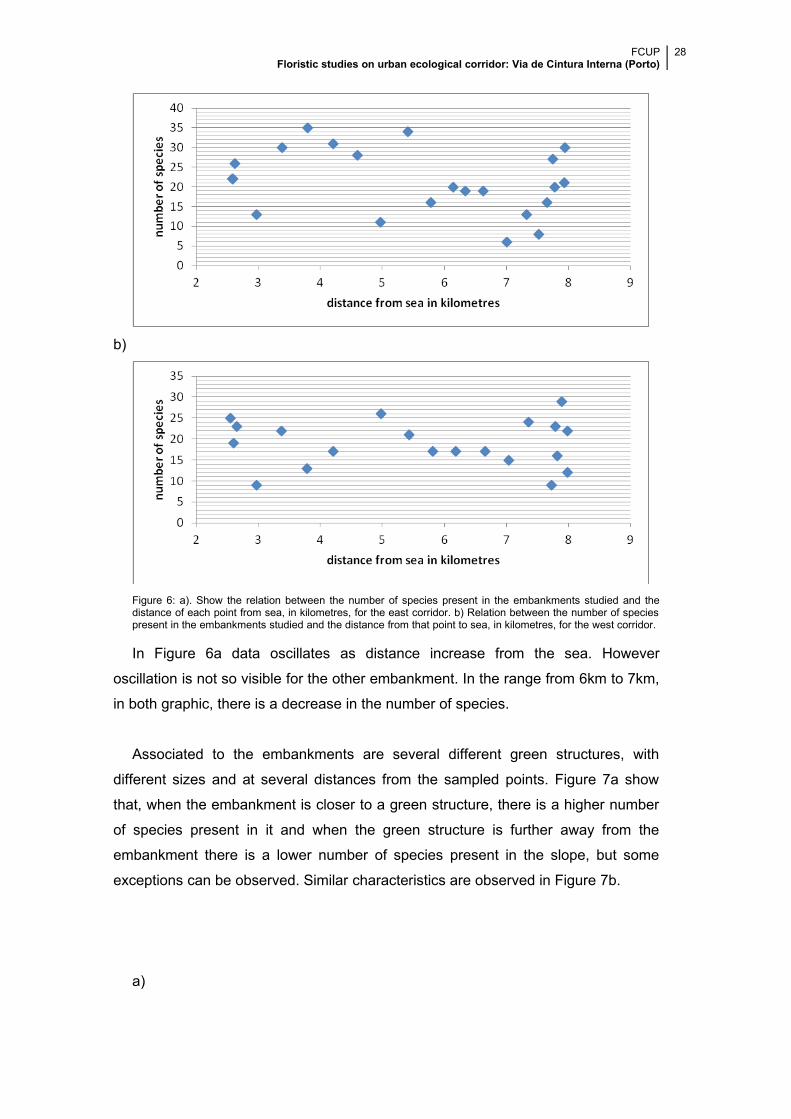
In the Figure 6a it is possible to observe that there is a tendency to a decrease in
species numbers, in the embankment, as the distance from sea increases. From the
5th km forward there is a decrease in the number of species present in the
embankment. The highest number of species is shown between kilometres 3 and 4.
In Figure 6b it is possible to observe that the number of species is higher around
2 km from sea but it decreases in the next kilometre. From kilometre 3 to 5 the
number of species increases. From kilometre 5 to 7 again it is possible to observe a
decrease in the number of species present in the embankments. Around the 8th
kilometre it seems that the number of species increases again. The higher number
of species is found at 7.89km where 29 different species were found. It is possible to
observe that for this embankment it isn’t shown a pattern of decrease or increase in
the number of species present.
a)
FCUP Floristic studies on urban ecological corridor: Via de Cintura Interna (Porto)
28
b)
Figure 6: a). Show the relation between the number of species present in the embankments studied and thedistance of each point from sea, in kilometres, for the east corridor. b) Relation between the number of speciespresent in the embankments studied and the distance from that point to sea, in kilometres, for the west corridor.
In Figure 6a data oscillates as distance increase from the sea. However
oscillation is not so visible for the other embankment. In the range from 6km to 7km,
in both graphic, there is a decrease in the number of species.
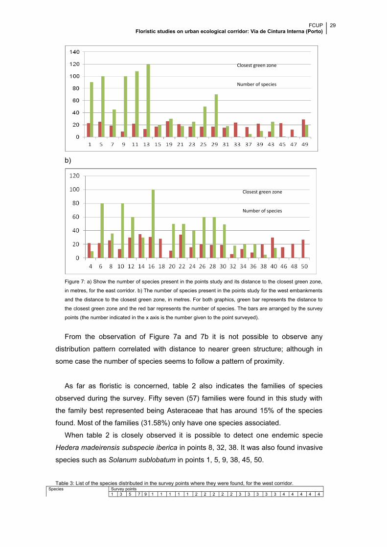
Associated to the embankments are several different green structures, with
different sizes and at several distances from the sampled points. Figure 7a show
that, when the embankment is closer to a green structure, there is a higher number
of species present in it and when the green structure is further away from the
embankment there is a lower number of species present in the slope, but some
exceptions can be observed. Similar characteristics are observed in Figure 7b.
a)
FCUP Floristic studies on urban ecological corridor: Via de Cintura Interna (Porto)
29
b)
Figure 7: a) Show the number of species present in the points study and its distance to the closest green zone,
in metres, for the east corridor. b) The number of species present in the points study for the west embankments
and the distance to the closest green zone, in metres. For both graphics, green bar represents the distance to
the closest green zone and the red bar represents the number of species. The bars are arranged by the survey
points (the number indicated in the x axis is the number given to the point surveyed).
From the observation of Figure 7a and 7b it is not possible to observe any
distribution pattern correlated with distance to nearer green structure; although in
some case the number of species seems to follow a pattern of proximity.
As far as floristic is concerned, table 2 also indicates the families of species
observed during the survey. Fifty seven (57) families were found in this study with
the family best represented being Asteraceae that has around 15% of the species
found. Most of the families (31.58%) only have one species associated.
When table 2 is closely observed it is possible to detect one endemic specie
Hedera madeirensis subspecie iberica in points 8, 32, 38. It was also found invasive
species such as Solanum sublobatum in points 1, 5, 9, 38, 45, 50.
Table 3: List of the species distributed in the survey points where they were found, for the west corridor.Species Survey points
1 3 5 7 9 1 1 1 1 1 2 2 2 2 2 3 3 3 3 3 4 4 4 4 4
Closest green zone
Number of species
Closest green zone
Number of species
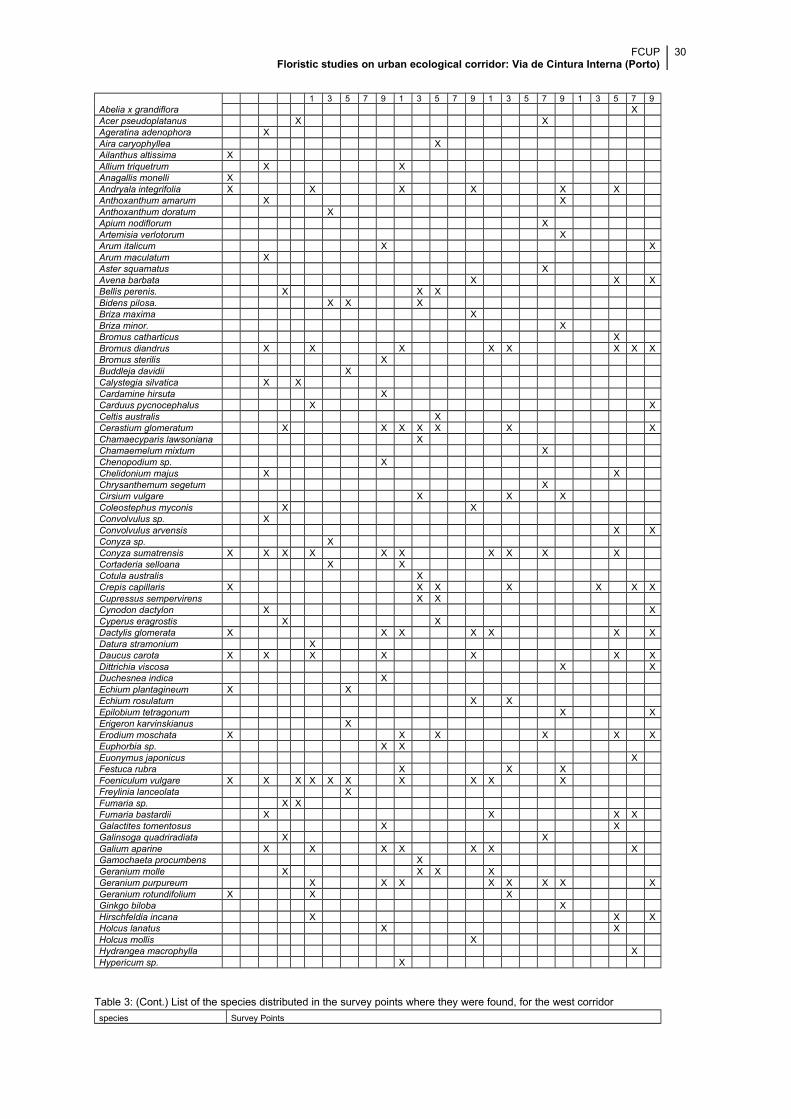
FCUP Floristic studies on urban ecological corridor: Via de Cintura Interna (Porto)
30
1 3 5 7 9 1 3 5 7 9 1 3 5 7 9 1 3 5 7 9Abelia x grandiflora XAcer pseudoplatanus X XAgeratina adenophora XAira caryophyllea XAilanthus altissima XAllium triquetrum X XAnagallis monelli XAndryala integrifolia X X X X X XAnthoxanthum amarum X XAnthoxanthum doratum XApium nodiflorum XArtemisia verlotorum XArum italicum X XArum maculatum XAster squamatus XAvena barbata X X XBellis perenis. X X XBidens pilosa. X X XBriza maxima XBriza minor. XBromus catharticus XBromus diandrus X X X X X X X XBromus sterilis XBuddleja davidii XCalystegia silvatica X XCardamine hirsuta XCarduus pycnocephalus X XCeltis australis XCerastium glomeratum X X X X X X XChamaecyparis lawsoniana XChamaemelum mixtum XChenopodium sp. XChelidonium majus X XChrysanthemum segetum XCirsium vulgare X X XColeostephus myconis X XConvolvulus sp. XConvolvulus arvensis X XConyza sp. XConyza sumatrensis X X X X X X X X X XCortaderia selloana X XCotula australis XCrepis capillaris X X X X X X XCupressus sempervirens X XCynodon dactylon X XCyperus eragrostis X XDactylis glomerata X X X X X X XDatura stramonium XDaucus carota X X X X X X XDittrichia viscosa X XDuchesnea indica XEchium plantagineum X XEchium rosulatum X XEpilobium tetragonum X XErigeron karvinskianus XErodium moschata X X X X X XEuphorbia sp. X XEuonymus japonicus XFestuca rubra X X XFoeniculum vulgare X X X X X X X X X XFreylinia lanceolata XFumaria sp. X XFumaria bastardii X X X XGalactites tomentosus X XGalinsoga quadriradiata X XGalium aparine X X X X X X XGamochaeta procumbens XGeranium molle X X X XGeranium purpureum X X X X X X X XGeranium rotundifolium X X XGinkgo biloba XHirschfeldia incana X X XHolcus lanatus X XHolcus mollis XHydrangea macrophylla XHypericum sp. X
Table 3: (Cont.) List of the species distributed in the survey points where they were found, for the west corridor
species Survey Points
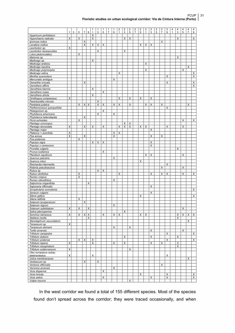
FCUP Floristic studies on urban ecological corridor: Via de Cintura Interna (Porto)
31
1 3 5 7 911
13
15
17
19
21
23
25
27
29
31
33
35
37
39
41
43
45
47
49
Hypericum perfoliatum XHypochaeris radicata X X X X X X XIpomoea indica X XLavatera cretica X X X X X X XLeontodon sp. XLeontodon taraxacoides X XLotus pedunculatus. XMahonia sp. X Medicago sp. XMedicago arabica. XMedicago lupulina XMedicago polymorpha X XMedicago sativa X XMentha suaveolens X XMercurialis ambigua XOenanthe crocata X X XOenothera affinis XOenothera biennis XOenothera rosea XOenothera stricta XOrnithopus compressus X X X X XParentucellia viscosa XParietaria judaica X X X X X X X X X X X XParthenocissus quinquefolia XPelargonium sp. XPhytolacca americana X XPhytolacca heterotepala XPicris echioides X X XPlantago coronopus X XPlantago lanceolata X X X X X X X X X X XPlantago major XPlatanus × acerifolia X X XPoa annua X X X X XPoa pratensis XPopulus nigra X X X XPopulus x canescens XPrunella vulgaris XPrunus lusitanica XPteridium aquilinum X X XQuercus palustris. XQuercus robur XReichardia intermedia XRobinia pseudoacacia X XRubus sp. X XRubus ulmifolius X X X X X X XRumex crispus XRumex obtusifolius XSalpichroa origanifolia XSaponaria officinalis XScrophularia scorodonia XSenecio vulgaris XSilene gallica X XSilene latifolia XSolanum lycopersicum XSolanum nigrum XSolanum sublobatum X X X XSoliva pterosperma XSonchus oleraceus. X X X X X X X X X X X X XStellaria media X XStenotaphrum secundatum XTaraxacum sp. XTaraxacum ekmanii X XTorilis arvensis X XTrifolium campestre X XTrifolium dubium X X XTrifolium pratense X X X X XTrifolium repens X X X X X X XTrifolium resupinatum XTrifolium subterraneum X XUlex europaeus subsp. latebracteatus X X XUrtica membranacea XVerbascum sp. X XVerbena officinalis XVeronica arvensis XVicia disperma XVicia hirsuta X X XVicia sativa X X X XVulpia myuros X
In the west corridor we found a total of 155 different species. Most of the species
found don’t spread across the corridor; they were traced occasionally, and when
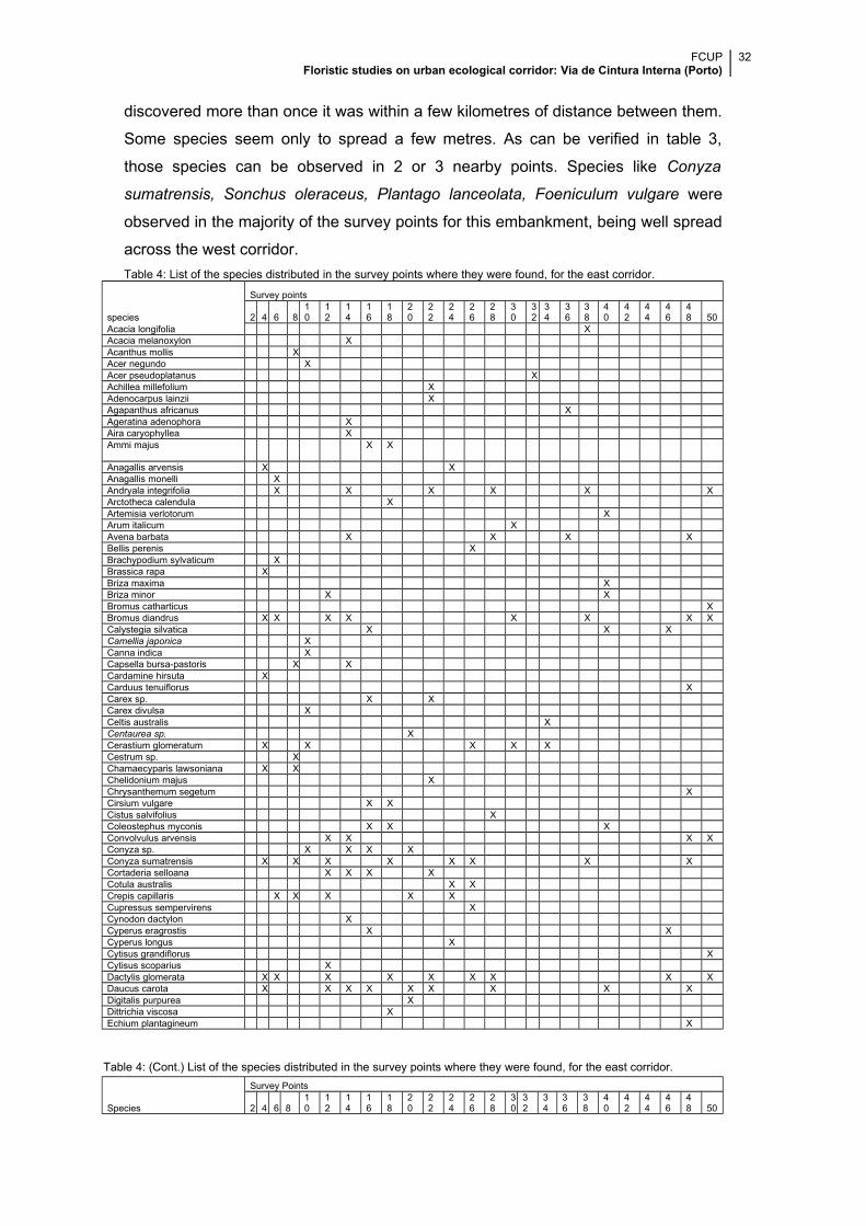
FCUP Floristic studies on urban ecological corridor: Via de Cintura Interna (Porto)
32
discovered more than once it was within a few kilometres of distance between them.
Some species seem only to spread a few metres. As can be verified in table 3,
those species can be observed in 2 or 3 nearby points. Species like Conyza
sumatrensis, Sonchus oleraceus, Plantago lanceolata, Foeniculum vulgare were
observed in the majority of the survey points for this embankment, being well spread
across the west corridor.
Table 4: List of the species distributed in the survey points where they were found, for the east corridor.
species
Survey points
2 4 6 810
12
14
16
18
20
22
24
26
28
30
32
34
36
38
40
42
44
46
48 50
Acacia longifolia XAcacia melanoxylon XAcanthus mollis XAcer negundo XAcer pseudoplatanus XAchillea millefolium XAdenocarpus lainzii XAgapanthus africanus XAgeratina adenophora XAira caryophyllea XAmmi majus X X
Anagallis arvensis X XAnagallis monelli XAndryala integrifolia X X X X X XArctotheca calendula XArtemisia verlotorum XArum italicum XAvena barbata X X X XBellis perenis XBrachypodium sylvaticum XBrassica rapa XBriza maxima XBriza minor X XBromus catharticus XBromus diandrus X X X X X X X XCalystegia silvatica X X XCamellia japonica XCanna indica XCapsella bursa-pastoris X XCardamine hirsuta XCarduus tenuiflorus XCarex sp. X XCarex divulsa XCeltis australis XCentaurea sp. XCerastium glomeratum X X X X XCestrum sp. XChamaecyparis lawsoniana X XChelidonium majus XChrysanthemum segetum XCirsium vulgare X XCistus salvifolius XColeostephus myconis X X XConvolvulus arvensis X X X XConyza sp. X X X XConyza sumatrensis X X X X X X X XCortaderia selloana X X X XCotula australis X XCrepis capillaris X X X X XCupressus sempervirens XCynodon dactylon XCyperus eragrostis X XCyperus longus XCytisus grandiflorus XCytisus scoparius XDactylis glomerata X X X X X X X X XDaucus carota X X X X X X X X XDigitalis purpurea XDittrichia viscosa XEchium plantagineum X
Table 4: (Cont.) List of the species distributed in the survey points where they were found, for the east corridor.
Species
Survey Points
2 4 6 810
12
14
16
18
20
22
24
26
28
30
32
34
36
38
40
42
44
46
48 50
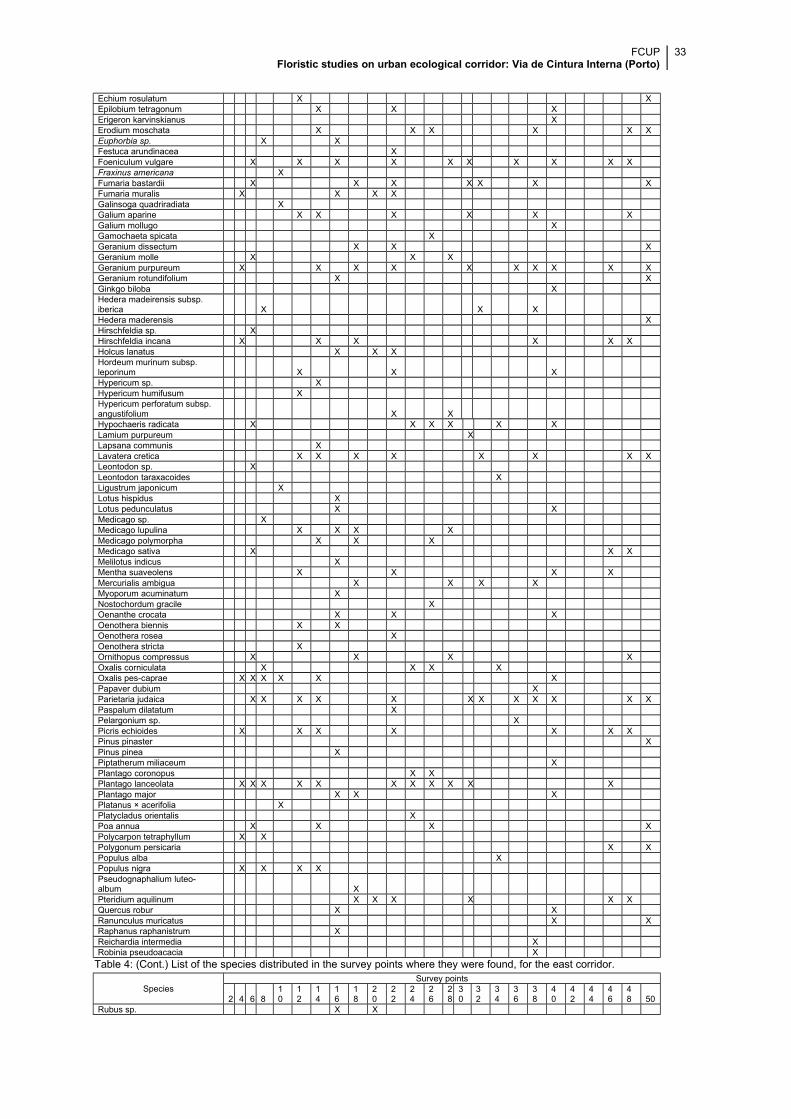
FCUP Floristic studies on urban ecological corridor: Via de Cintura Interna (Porto)
33
Echium rosulatum X XEpilobium tetragonum X X XErigeron karvinskianus XErodium moschata X X X X X XEuphorbia sp. X XFestuca arundinacea XFoeniculum vulgare X X X X X X X X X XFraxinus americana XFumaria bastardii X X X X X X XFumaria muralis X X X XGalinsoga quadriradiata XGalium aparine X X X X X XGalium mollugo XGamochaeta spicata XGeranium dissectum X X XGeranium molle X X XGeranium purpureum X X X X X X X X X XGeranium rotundifolium X XGinkgo biloba XHedera madeirensis subsp. iberica X X XHedera maderensis XHirschfeldia sp. XHirschfeldia incana X X X X X XHolcus lanatus X X XHordeum murinum subsp. leporinum X X XHypericum sp. XHypericum humifusum XHypericum perforatum subsp. angustifolium X XHypochaeris radicata X X X X X XLamium purpureum XLapsana communis XLavatera cretica X X X X X X X XLeontodon sp. XLeontodon taraxacoides XLigustrum japonicum XLotus hispidus XLotus pedunculatus X XMedicago sp. XMedicago lupulina X X X XMedicago polymorpha X X XMedicago sativa X X XMelilotus indicus XMentha suaveolens X X X XMercurialis ambigua X X X XMyoporum acuminatum XNostochordum gracile XOenanthe crocata X X XOenothera biennis X XOenothera rosea XOenothera stricta XOrnithopus compressus X X X XOxalis corniculata X X X XOxalis pes-caprae X X X X X XPapaver dubium XParietaria judaica X X X X X X X X X X X XPaspalum dilatatum XPelargonium sp. XPicris echioides X X X X X X XPinus pinaster XPinus pinea XPiptatherum miliaceum XPlantago coronopus X XPlantago lanceolata X X X X X X X X X X XPlantago major X X XPlatanus × acerifolia XPlatycladus orientalis XPoa annua X X X XPolycarpon tetraphyllum X XPolygonum persicaria X XPopulus alba XPopulus nigra X X X XPseudognaphalium luteo-album XPteridium aquilinum X X X X X XQuercus robur X XRanunculus muricatus X XRaphanus raphanistrum XReichardia intermedia XRobinia pseudoacacia X
Table 4: (Cont.) List of the species distributed in the survey points where they were found, for the east corridor.
SpeciesSurvey points
2 4 6 810
12
14
16
18
20
22
24
26
28
30
32
34
36
38
40
42
44
46
48 50
Rubus sp. X X
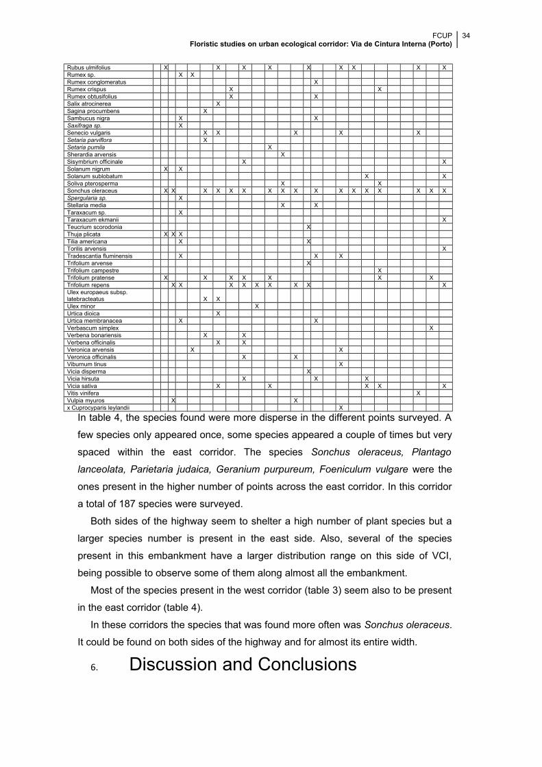
FCUP Floristic studies on urban ecological corridor: Via de Cintura Interna (Porto)
34
Rubus ulmifolius X X X X X X X X XRumex sp. X XRumex conglomeratus XRumex crispus X XRumex obtusifolius X XSalix atrocinerea XSagina procumbens XSambucus nigra X XSaxifraga sp. XSenecio vulgaris X X X X XSetaria parviflora XSetaria pumila XSherardia arvensis XSisymbrium officinale X XSolanum nigrum X XSolanum sublobatum X XSoliva pterosperma X XSonchus oleraceus X X X X X X X X X X X X X X X X XSpergularia sp. XStellaria media X XTaraxacum sp. XTaraxacum ekmanii XTeucrium scorodonia XThuja plicata X X XTilia americana X XTorilis arvensis XTradescantia fluminensis X X XTrifolium arvense XTrifolium campestre XTrifolium pratense X X X X X X XTrifolium repens X X X X X X X X XUlex europaeus subsp. latebracteatus X XUlex minor XUrtica dioica XUrtica membranacea X XVerbascum simplex XVerbena bonariensis X XVerbena officinalis X XVeronica arvensis X XVeronica officinalis X XViburnum tinus XVicia disperma XVicia hirsuta X X XVicia sativa X X X X XVitis vinifera XVulpia myuros X Xx Cuprocyparis leylandii X
In table 4, the species found were more disperse in the different points surveyed. A
few species only appeared once, some species appeared a couple of times but very
spaced within the east corridor. The species Sonchus oleraceus, Plantago
lanceolata, Parietaria judaica, Geranium purpureum, Foeniculum vulgare were the
ones present in the higher number of points across the east corridor. In this corridor
a total of 187 species were surveyed.
Both sides of the highway seem to shelter a high number of plant species but a
larger species number is present in the east side. Also, several of the species
present in this embankment have a larger distribution range on this side of VCI,
being possible to observe some of them along almost all the embankment.
Most of the species present in the west corridor (table 3) seem also to be present
in the east corridor (table 4).
In these corridors the species that was found more often was Sonchus oleraceus.
It could be found on both sides of the highway and for almost its entire width.
6. Discussion and Conclusions
FCUP Floristic studies on urban ecological corridor: Via de Cintura Interna (Porto)
35
Porto’s city is a developed and urbanized metropolis and as well as others
urbanized towns it show several problems related to noise and air pollution as well
as landscape fragmentation. As the city grew, the connectivity inside it had to be
improved, increasing the number of accesses such as highways and roads. These
connections posed many problems to natural life blocking animal and plant species
from spreading across the territory.
VCI surrounds Porto inner city and along its entire length there are embankments
that could provide habitat for animals and plants.
In this work, embankments were studied and it has been found that most of the
VCI’s margins don’t have a high slope and present a constant sun exposure. No
actual use for these spaces is known and most of them are narrow, with an average
width around 7-9 m although some have more than 10m (to a maximum of 100m).
The variables analysed - distance from the river, distance from the sea and
distance to the nearby green zones - seems to have some influence in vegetation
when analysed isolated, but there are so many factors conjugated that a
influence/distribution pattern barely can be observed.
According to Bryant (2006) nature found in urbanized context is very different
from that within the urban fringe (gardens, exotic and invasive plants, etc.). Although
Porto is a developed city, small rural patches which may affect embankments’ fauna
and flora, still can be seen. Therefore, a larger number of species can be located
further away from the river and in that case proximity to gardens and fields could
actually be acting as stepping stones.
Most of the surveyed points had at least 9 different species, even the ones with
shortest width. No clear vegetation distribution patterns were found throughout the
highway corridor. In these corridors flora is trapped in an early successional stage,
maintained through mowing applied for aesthetical and traffic safety reason as well
by urban by-laws (Ranta, 2008).
Despite the destruction caused by maintenance, a high number of different
species was found during the survey. This fact has been seen in other studies; the
number of species tend to increase when there is a frequent mowing regime, but
when this regime goes for a long period of time the number of species decrease
(Yang, 2012; Kolos, 2013) . The VCI embankments mowing regime is not going on
for a long time yet and it only seem to occurs twice a year (at least in most of VCI’s
extension) so the number of species present could decrease in a few years and so it
FCUP Floristic studies on urban ecological corridor: Via de Cintura Interna (Porto)
36
would be better adapt the mowing regime to the species found in these
embankments as proposed by Ranta (2008). However, the growing use of
herbicides in several places along this structure can change the floristic data
presented in this work, rather quickly.
The vegetation found, especially communities of shrubs-grassland plants can be
able to provide habitat for some species of animals. Although not studied it’s an
interesting reference for future works.
Accessibility and fencing (50% and 46% respectively in VCI slopes) are important
factors in a greenway; although fencing is a necessity in questions of safety, also
creates serious barriers to access. Probably fencing is one of the main reasons why
VCI embankments don’t have cultural or recreational functions.
Samways (2010) propose that a greenway need to be at least 200m wide to be
an actual greenway, this condition is not satisfied by the embankments of VCI who
present widths estimated between 1 and 100m.
Taking into account the findings described previously, it can be said that the
embankments of VCI constitute a linear green structure with only one or two
functions: the ecological one and possibly the social one. It doesn’t have a cultural
or a recreational function or even an educational one. So, it is possible to say that
those corridors could be ecological corridors but not a greenway due to lack of the
multi-function characteristic.
The first designs for the VCI highway had a more cultural and recreational
characteristic that was excluded from the original plan. However, it is still possible to
find some remnants of those projects that could be explored and used to improve
the quality of life for those who live in the highway surroundings and for its users.
It is possible that the entire highway couldn’t be altered to become an actual
greenway, but it could be possible to do it in some areas of the highway because
46% of its width has no fences and 36% has difficult, but not impossible, access that
could be improved to allow public admission.
The educational asset could also be introduced in the VCI by allowing the
students to see and study the pollution effects, caused by exhaust fumes released
by cars or garbage thrown into the embankments.
To become a greenway, VCI’s embankments need to have their access improved
and some of the fences removed which means that some of the green areas need to
be acquired from its owners. It is necessary to promote the greenway concept
among the future greenway nearby habitants. This promotion will help to increase
FCUP Floristic studies on urban ecological corridor: Via de Cintura Interna (Porto)
37
the interest in the project and it may facilitate the collaboration between the different
stakeholders (Viles, 2001; Bryant, 2006; Frischenbruder, 2006).
The intervention in a greenway in general and in VCI in particular, would be
better if made at a local or regional scale taking in account the ideas and opinions of
the people that will be affect by the greenway outcome (Bryant, 2006).
A coordinated effort between landscape ecologists, landscape architects, city
planners is also needed to improve the quality of life around the VCI corridor and to
improve the VCI embankment so it will became an actual greenway.
In this work, it wasn’t possible to obtain data from all the points surveyed for the
reasons stated before (impossibility of access according to the Portuguese law or
just physical impossibility mainly caused by obstacles).
In forthcoming works or future research, would be interesting to determine if the
VCI embankments actually act as a sink for pollution and/or how can be used to
control water fluxes.
To ascertain the ecological efficiency of VCI’s embankments, it would be
necessary monitoring and execute interdisciplinary studies in the area in a regular
basis over a large amount of time.
In conclusion VCI embankments’ are not a “greenway”, even though it shows
some ecological features, but lack the multifunctional characteristic and therefore
doesn’t allow for the application of the present concept. As a summary of the
principal conclusions it can be said:
It was observed that almost all the embankments were constantly exposed to
the sun. Most of the points studied had no previous use but the majority of the
points can be public accessed. The high number of fenced points poses as a
problem for the application of greenways multifunctional characteristic.
In the 47 points surveyed, 219 different species and 57 different families were
found. Several potential invasive species were identified throughout the
corridor. Also, a high number of species found were exotic.
As distance to the river increases seems to produce a rising effect in the
number of species. However this effect can be associated to the fact that rural
patches are to be found also far away from the river.
An inverse effect can be observed when distance to the sea declines. This
behaviour can be probably associated with the effects of salt spray although no
causes for that behaviour were found, except for a decreasing in the width of
FCUP Floristic studies on urban ecological corridor: Via de Cintura Interna (Porto)
38
the embankment, due to use of land for construction purposes, number of
highway exits and population density.
Embankments width also seems to play an important role in the number of
species present. A relation between slope size and number of species couldn’t
be draw. But intuitively seems to exist. However, embankments with less than
10m are the easiest to maintain and therefore treatments (mowing, herbicide
applications, etc.) can be easily applied and more intense.
The importance of embankment “width” can also be masked by the fact that
many times narrow slopes have been planted with gymnosperms which will
influence the number of species present due to soil acidification, shadow and
other factors. Moreover, in some surveyed points, where gymnosperms weren’t
present, it was observed many times, that vegetation cover was composed
almost by one or two Poaceae species, clearly chosen and applied by the
municipality services. In some places the lack of treatments or/and the difficulty
of access allowed some particular species, as Rubus sp., to develop and
becoming dominant preventing the developing of other vegetation types. Thus,
again results could mask not only the “width” effect but also other variables
such as proximity to green areas.
Most of the points studied have a green structure near them. This particular
factor seems to improve the number of species present in the embankments
and acting as possible stepping stones (but see previous points).
The results of this work could aid to increase the knowledge of the studied area
but a complete and multidisciplinary survey should be made to help improve the
condition of life for the surrounding habitants and increase biodiversity.
FCUP Floristic studies on urban ecological corridor: Via de Cintura Interna (Porto)
39
BibliographyAlberti, Marina, 1996. Measuring urban sustainability. Environ impact assess rev 16,
381-424.
Alberti, Marina, Susskind, Lawrence, 1996. Managing urban sustainability: an
introduction to the special issue. Environ impact assessment rev 16, 213-221.
Alberti, Marina, Marzluff, Jonh M., Shulenberger, Eric, Bradley, Gordon, Ryan, Clare,
Zumbrunnen, Craig, 2003. Integrating humans into ecology: opportunities and
challenges for studying urban ecosystems. Bioscience 53 (12).
Angold, P. G., Sadler, J. P., Hill, M. O., Pullin, A., Rushton, S., Austin, K., Small, E.,
Wood, b., Wadsworth, R., Sanderson, R., Thompson, K., 2006. Biodiversity in urban
habitat patches. Science of the Total Environment 360, 196-204.
Ahern, Jack, 2002. Greenways as strategic landscape planning: theory and application.
Wageningen University.
Ahern, Jack, 1995. Grennways as a planning and persuasive idea around which to
structure communities. Landscape and Urban Planning 33, Elsevier.
Barros, Nelson, Brás, Catarina, Fontes, Tânia, 2004. Impacte na qualidade do ar e na
saúde pública das grandes linhas de trafego: O caso da VCI- projecto impactair.
Faculdade de Ciência e Tecnologia.
Bryant, M. Margaret, 2006. Urban landscape conservation and the role of ecological
greenways at local and metropolitan scales. Landscape and Urban Planning 76, 23-44.
Chapman, David, Pratt, Dick, Larkham, Peter, Dickins, Ian, 2003. Concepts and
definitions of corridors: evidence from England’s Midlands. Journal of transport
geography 11, 179-191.
Collinge, Sharon K., 1998. Spatial arrangement of habitat patches and corridors: Clues
from ecological field experiments. Landscape and Urban Planning 42, 157-168.
Dawson, Kerry J., 1995. A comprehensive conservation strategy for Georgia’s
greenways. Landscape and Urban Planning 33, Elsevier.
Davis, Kingsley, 1973. Cities their origin, growth and human impact. Scientific
American.
FCUP Floristic studies on urban ecological corridor: Via de Cintura Interna (Porto)
40
Fabos, J.G., 2004. Greenway planning in the United States: its origins and recent case
studies. Landscape Urban Plan. 68, 321–342.
Fabos, J.G., Ahern, J., 1995. Greenways: The Beginning of an International Movement.
Elsevier.
Fernandes, José A. V. Rio, 2005. Porto: Um percurso urbano. Include Fernandes, José
A. V. Rio, 2002. Porto e Salvador: dois percursos urbanos distintos. O Tripeiro, 8.
Porto.
Flink, Charles A., 1993. Greenways : a guide to planning, design, and development
/ Charles A.Flink, Robert M. Searns ; ed. Loring LaB. Schwarz
Forman, Richard T. T., Deblinger, Robert D., 2000. The ecological road-effect zone of
a Massachusetts (U.S.A.) suburban highway. Conservation Biology 14, 36-46.
Frischenbruder, Marisa T. Mamede, Pellegrino, Paulo, 2006. Using greenways to
reclaim nature in Brazilian cities. Landscape and urban planning 76, 67-78.
Hahs, Amy K., McDonnell, Mark J., 2006. Selecting independent measures to quantify
Melbourne’s urban-rural gradient. Landscape and urban planning 78, 435-448.
Hepinstall-Cymerman, Jeffrey, Coe, Stephan, Hutyra, Lucy R., 2011. Urban growth
patterns and growth management boundaries in the Central Puget Sound, Washington,
1986-2007. Urban ecosystems.
Hepinstall, Jeffrey A., Alberti, Marina, Marzluff, John M., 2008. Predicting land cover
change and avian community responses in rapidly urbanizing environments.
Landscape ecology 23, 1257-1276.
Hostetler, Mark, Allen, Will, Meurk, Colin, 2011. Conserving urban biodiversity?
Creating green infrastructure is only the first step. Landscape and urban planning 100,
369-371.
Ignatieva, Maria, Stewart, Glenn H., Meurk, Colin, 2011. Planning and design of
ecological networks in urban areas. Landscape and ecological engineering 7, 17-25.
Kolos, Aleksander, Banaszuk, Pitr, 2013. Mowing as a tool for wet meadows
restoration: effect of long-term management on species richness and composition of
sedge- dominated wetland. Ecological Engineering 55, 23-28.
FCUP Floristic studies on urban ecological corridor: Via de Cintura Interna (Porto)
41
Liu, Jianguo, Dietz, Thomas, Carpenter, Stephen R., Alberti, Marina, Folke, Carl,
Moran, Emilio, Pell, Alice N., Deadman, Peter, Kratz, Timothy, Lubchenco, Jane,
Ostrom, Elinor, Ouyang, Zhiyun, Provencher, William, Redman, Charles L., Schneider,
Stephen H., Taylor, William W., 2007. Complexity of coupled human and natural
systems. Science 317
Lowry, William P., (1961) 1973. The Climate of cities. Cities their origin, growth and
human impact. Scientific American.
Maestas, Jeremy D., Knight, Richard L., Gilbert, Wendell C., 2003. Biodiversity across
a Rural Land-use gradient. Conservation Biology 17, 1425-1434.
Magalhães, Manuela Raposo, 1992. Espaços verdes urbanos. Direcção Geral do
Ordenamento do Território.
McDermott, Walsh, (1961) 1973. Air pollution and public health. Cities their origin,
growth and human impact. Scientific American.
McIntyre, N. E., Knowles-Yánez, K., Hope, D., 2000. Urban ecology as an
interdisciplinary field: differences in the use of “urban” between the social and natural
sciences. Urban ecosystems 4, 5-24
Michalak, Julia, 2011. Effects of habitat and landscape structure on Oregon White Oak
(Quercus garryana) regeneration across an urban gradient. Northwest Science 85,
182-193.
Perreira, Miguel Ângelo Silva, Neves, Nuno Alexandre Gouveia de Sousa, Figueiredo,
Diogo Francisco Caeiro, 2007. Considerações sobre a fragmentação territorial e as
redes de corredores ecológicos. Geografia 16.
Ranta, Pertti, 2008. The importance of traffic corridors as urban habitats for plants in
Finland. Urban Ecosyst 11, 149-159.
Roy, A., Devi, B. S. S., Debnath, B., Murthy, M. S. R., 2010. Geospatial modeling for
identification of potential ecological corridors in Orissa. Biodiversity and Landscape
Ecology 38, 387-399.
Samways, M. J., Bazelet, C. S., Pryke, J. S., 2010. Provision of ecosystem services by
large scale corridors and ecological networks. Biodiversity and conservation 19, 2949-
2962.
FCUP Floristic studies on urban ecological corridor: Via de Cintura Interna (Porto)
42
Searns, Robert M., 1995. The evolution of the greenways as an adaptive urban
landscape form. Landscape and Urban Planning 33, 65-80.
Seiler, Andreas, 2001. Ecological effects of roads: A review. Introductory Research
Essay. Department of conservation Biology S. L. U. 9.
Shaw, George Bernard, (1903) 1973. The evolution of western industrial. Cities their
origin, growth and human impact. Scientific American.
Sucena, Sara, 2004. A Via de Cintura Interna como elemento de estrutura urbana?
Uma análise e comparação com a Ronda de Dalt- Barcelona. Faculdade de Ciências e
Tecnologia.
Taylor, James, 1995. From greenbelt to greenways: four Canadian case studies.
Landscape and Urban Planning 33, Elsevier.
Viles, R. L., Rosier, D. J., 2001. How to use roads in the creation of greenways: case
studies in three New Zealand landscapes. Landscape and Urban Planning 55, 15-27.
Vogt, Peter, Riitters, Kurt H., Iwanowski, Marcin, Estreguil, Christine, Kozak, Jacek,
Soille, Pierre, 2007. Mapping landscape corridors. Ecological indicators 7, 481-488.
Waldhardt, Rainer, 2003. Biodiversity and landscape – summary, conclusions and
perspectives. Agriculture, Ecosystems and Environment 98, 305-309.
Walmsley, Anthony, 1995. Greenways and the making of urban form. Landscape and
Urban Planning 33, 81-127.
Wu, Jianguo, Jenerette, G. Darrel, Buyantuyev, Alexander, Redman, Charles L., 2011.
Quantifying spatiotemporal patterns of urbanization: the case of the two fastest growing
metropolitan regions in the United States. Ecological complexity 8, 1-8.
Yang, Haijun, Jiang, Lin, Li, Linghao, Li, Ang, Wu, Mingyu, Wan, Shiqiang, 2012.
Diversity-dependent stability under mowing and nutrient addition: evidence from a 7-
year grassland experiment. Ecology letters 15, 619-626.
Zipperer, Wayne C., Guntenspergen, Glenn R.,2009. Vegetation composition and
structure of forest patches along urban-rural gradients. Ecology of Cities and Towns: A
comparative Approach. Cambridge University Press.
Zube, Ervin H., 1995. Greenways and the US national park system. Landscape and
Urban Planning 33, Elsevier.
FCUP Floristic studies on urban ecological corridor: Via de Cintura Interna (Porto)
43
(10/6/2013). Jardim Botânico. Universidade de Trás-os-Montes e Alto Doudo.
http://jb.utad.pt/pesquisa
(10/6/2013).Missouri Botanical Garden.
http://www.missouribotanicalgarden.org/gardens-gardening/your-garden/plant-
finder.aspx
(10/6/2013). United States Department of Agriculture. Natural Resources conservation
services. http://plants.usda.gov/checklist.html