Embed Size (px)
Citation preview

Eighteenth International Water Technology Conference, IWTC18 Sharm ElSheikh, 12-14 March 2015
298
STUDY OF ALAQI SECONDARY CHANNEL IN NASSER LAKE
GamalSallam, MohamedIhab, Waleed Emary
1Associate Professor, National water Research Center, [email protected]
High Dam Authority, [email protected]
2Research Assistance, National water Research Center, waleed [email protected]
ABSTRACT
Lake Nasser/Nubia studies have been included in many researches for national and international
experts to give the required information to the decision makers about present and future status of the
major water tank for both Egypt and Sudan. A key stone of all of these studies is to have sufficient
information about the lake and its characteristics. Lake Nasser has hundreds of secondary channels, some
of them are relatively small and shallow and some others are very wide, extended and deep. One of the
largest secondary channels that have never been surveyed for a long time is Alaqi Secondary channel.
Alaqi Secondary Channel is located at about 110 km upstream the High Aswan Dam on the eastern side
of Nasser Lake. A field mission to Nasser Lake secondary channels was carried out in October, 2013. It
was aim to collect all related data and develop bathymetric charts for Nasser Lake secondary channels in
Egypt. The evaporation losses from Alaqi secondary channel is about 0.72 BCM (at W.L. 175.00 m
(AMSL)), the evaporation losses from Alaqi secondary channel is about 6 % of evaporation losses from
Nasser Lake. It is proposed to close this secondary channel by a dam to reduce the evaporation losses
from Nasser Lake.
It could be concluded from the research that water evaporation in Nasr Lake can be reduced and
controlled by closing Alaqi secondary channel.
The objectives of this study are to manage the lake storage capacity, estimate the evaporation losses,
propose a closing dam, and to help in lake simulation processes.
Keywords: Lake Nasser, Alaqi secondary channel, Evaporation losses
1. INTRODUCTION
Lake Nasser/Nubia studies have been included in many researches for national and international
experts to give the required information to the decision makers about present and future status of the
major water tank for both Egypt and Sudan. A key stone of all of these studies is to have sufficient
information about the lake and its characteristics. These characteristics include discharges, water levels,
environment, meteorological data, lake topography, and other factors. The lake bed topography is one of
these factors that have been surveyed since the lake formation.
Lake Nasser/Nubia Has hundreds of secondary channels, some of them are relatively small and shallow
and some others are very wide, extended and deep. One of the largest secondary channels that have never
been surveyed is Alaqi Secondary channels. Figure 1 shows Alaqi secondary channels.

Eighteenth International Water Technology Conference, IWTC18 Sharm ElSheikh, 12-14 March 2015
299
Figure 1. Alaqi secondary channel
A field mission to Nasser Lake secondary channels was carried out in October, 2013. It was aim to
collect all related data and develop bathymetric charts for Nasser Lake secondary channels in Egypt. The
bathymetric charts when archived will give in depth picture to the historical development in the
deposition in Lake Nasser secondary channels. This was successfully carried out through the joined
efforts of Nile Research Institute and Aswan High Dam Authority. Three field survey Teams using multi
beam eco-sounding system, and two single beam systems were used. The teams managed to collect dense
data set for Nasser Lake secondary channels. The teams surveyed cross sections at average space of 1
kilometer using three boats.
Another field team was working on a tug boat carried out flow current measurements and bed material
sampling at specific locations. The data was compiled in office and contour maps were deducted. These
data sets when compiled with previous historical data can be utilized when applying numerical model to
predict future changes in these secondary channels. Figure 2 shows Alaqi secondary channel survived
cross sections.

Eighteenth International Water Technology Conference, IWTC18 Sharm ElSheikh, 12-14 March 2015
300
Figure 2. Alaqi secondary channel survived cross sections
2. DATA COLLECTION
2.1 Hydrographic Survey
Three Hydrographic Survey Teams were assigned to collect hydrographic data. Cross
sections were planned and geo-referenced throughout Alaqi secondary channels. The space
between cross sections is about 1 kilometer. The cross sections were hydrographically surveyed
by the three teams. Two of the three teams used single beam echo sounder system for measuring
flow depth and global positioning system for momentarily position in terms of easting and
northing as Universal Transverse Mercator System (UTM). The position was corrected on the
spot by the integrated Omni star system into the GPS unit. That is, corrected position was
synchronized with depth from the echo-sounder through data logger by the use of Hypack
software. The data logger was a normal laptops computer.

Eighteenth International Water Technology Conference, IWTC18 Sharm ElSheikh, 12-14 March 2015
301
Figure 3. shows Alaqisecondary channel contour map
The third team used a multi-Beam depth sounding system for the first time. The system
was integrated with real time positioning of GPS. The system was successfully installed and used
in surveying cross sections. The multi-beam depth sounding system was capable on measuring
flow depths along a strip of cross section has a range of width between 100 m and 200 m
depending on flow depth. At the end, the system was capable on collecting huge data set for flow
depth with reasonable accuracy. Data was processed in office and integrated. Then, the resulted
data was used to draw the contour maps. Figure 3 shows Alaqi secondary channel contour map. 2.2 Bed Material Sampling
A bed material sampler was used to collect bed material at specific locations. The collected
bed material was analyzed at Nile Research Institute laboratory. The grain size distribution was
identified at each cross section. The analysis of these samples is useful in learning the process of
delta formation in Lake Nasser Secondary Channels and its advancement. Table 1 shows Alaqi
secondary channel bed material samples. As shown in table 1, the average size of D50 is about
0.17 mm, so Alaqi secondary channel bed can be classified as medium to fine sand.

Eighteenth International Water Technology Conference, IWTC18 Sharm ElSheikh, 12-14 March 2015
302
Table 1. Alaqi secondary channel bed material samples
2.3 Current Velocity
Flow Velocity was measured using Vale port velocity meter. This Vale meter is capable on
measuring flow velocity and its direction. So, velocity is measured in x-y coordinate. Therefore,
flow velocity can be known in the main flow direction and the perpendicular direction towards
the banks. The velocity is very low inside Alaqi secondary channel; it is equal about 0.10 m/s,
that is related to that, Alaqi secondary channel is closed at its end.
2.4 Suspended Matters
Suspended matter in water may consist of inorganic and organic particles. Inorganic
solids such as clay, silt, and other soil constituents are common in surface water. Organic
material such as plant fibers and biological solids (algal cells) are also common constituents of
surface waters. The suspended particles are the main source of turbidity in water, which always
interfere with the penetration of light. The importance of the suspended matters in water quality
assessment refers to their responsibility for pollutants transportation. They provide adsorption
sites for chemical and biological agents. In addition, the type and concentration of suspended
matter control the turbidity and transparency of water. In this mission water samples were
collected from cross sections each cross section divided into three locations (East, Middle and
West) at different depths including 0.5m from surface, 25%, 50%, 65% and 80% from total
depth. Table (2) shows Alaqi secondary channel suspended matters at sec 16 and sec 19
Dissolved oxygen refers to the level of free, non-compound oxygen present in water. It is an
important parameter in assessing water quality because of its influence on the organisms living
within a body of water. A dissolved oxygen level that is too high or too low can harm aquatic
life and affect water quality. The optimal level in an estuary for Dissolved Oxygen (DO) is
higher than 6 ppm. Table (2) shows that the average level of DO is 8 ppm which mean that Alaqi
secondary channel water is clear and fresh.
Generally Total dissolved solids (TDS) are normally discussed only for freshwater systems. The
principal application of TDS is in the study of water quality for streams, rivers and lakes, it is
used as an indication of aesthetic characteristics of drinking water. More exotic and harmful
elements of TDS are pesticides arising from surface runoff. Certain naturally occurring total
dissolved solids arise from the weathering and dissolution of rocks and soils. The United States
has established a secondary water quality standard of 500 mg/l to provide for palatability of
drinking water, Fresh water < 1,000 mg/L TDS. Table (2) shows that the average level of TDS is
150 mg/L which mean that Alaqi secondary channel water is clear and fresh.
Nile Research Institute
Cross Sec. Cross Sec. Km Location D50 D-Mean % Clay Classification
Name No mm mm Coarse Medium Fine Total Coarse Medium Fine Total
List for Characteristic Grain Size Parameters along the SiteBed Material Samples
Khor El-Allaki
Khor
El-
Allak
i
%Silt% Sand
Lake Nasser Khors October/2013
14 23° 06' 30.70"N & 32° 47' 57.08"E Middle 0.2539 0.2890 11.21 52.44 27.17 90.82 4.13 2.04 1.21 7.38 1.15 Medium to fine Sand
16 23° 02' 11.34"N & 32° 49' 30.44"E Middle 0.2715 0.3986 15.71 46.91 28.83 91.45 2.93 0.00 0.00 2.93 0.00 Medium to Fine Sand
21 22° 56' 24.87"N & 32° 55' 02.52"E Middle 0.1713 0.2034 7.33 37.36 32.04 76.74 7.24 4.64 3.82 15.70 6.95 Medium to Fine Sand
29 22° 54' 27.06"N & 33° 02' 55.77"E Middle 0.1319 0.1634 4.91 24.01 37.80 66.71 10.20 6.17 4.46 20.83 7.67 Silty Fine to Medium Sand
33 22° 53' 41.86"N & 33° 06' 24.08"E Middle 0.1616 0.2069 9.82 32.35 31.47 73.65 8.97 6.17 4.84 19.99 5.64 Silty Medium to Fine Sand
37 22° 50' 40.31"N & 33° 08' 12.22"E Middle 0.1477 0.2160 9.80 26.37 32.47 68.64 12.22 5.42 4.30 21.95 5.64 Silty Fine to Medium Sand
41 22° 48' 19.34"N & 33° 10' 46.35"E Middle 0.1992 0.2821 14.44 33.85 26.43 74.72 5.04 5.65 4.45 15.15 7.45 Medium to Fine Sand
Khor
El-
Allak
i

Eighteenth International Water Technology Conference, IWTC18 Sharm ElSheikh, 12-14 March 2015
303
Pure water has a pH very close to 7. The pH scale with a pH less than 7 are said to be acidic
and solutions with a pH greater than 7 are basic or alkaline. Table (2) shows that the average
level of PH is 8 which mean that Alaqi secondary channel water is clear and fresh.
Table 2. Alaqi secondary channel suspended matters at sec 16 and sec 19
TDS (mg/l)
E.Cμs/cm
D.O mg/l PH Temperature (ç) Transparent Seecchi (m)
Total Depth (m)
Time Position Location
Date
Water Air
151.6 237 8.1 8.18 29.0 35
4
11.85
3.15
50 cm
E
Se
c.
(19
)
26
/9/2
01
3
-------- -------- -------- -------- -------- 25%
151.6 237 8.3 8.18 28.9 50%
-------- -------- -------- -------- -------- 65%
151 236 8.3 8.18 28.8 80%
151.6 237 8.4 8.13 29.5 35
4
27.5
3.45
50 cm
M 151.0 236 8.4 8.14 29.2 25%
152.3 238 8.4 8.12 29.2 50%
151.0 236 8.2 8.15 29.2 65%
151.6 237 8.3 8.14 29.3 80%
151.6 237 8.4 8.05 29.9 35
4
14.4
4.30
50 cm
W -------- -------- -------- -------- -------- 25%
151.6 237 8.5 8.07 29.7 50%
-------- -------- -------- -------- -------- 65%
151.6 237 8.4 8.05 29.8 80%
152.9 239 7.8 8.06 29 30
3.5
7.60
12.45
50 cm
E
Se
c.
(16
)
27
/9/2
01
3
-------- -------- -------- -------- -------- 25%
152 238 7.8 8.09 28.5 50%
-------- -------- -------- -------- -------- 65%
152 238 7.9 8.08 28.4 80%
152 238 7.8 7.98 29.1 30
3.5
43
11.50
50 cm
M 152 238 7.9 7.95 28.4 25%
152 238 7.6 7.94 28.3 50%
152 238 7.6 7.95 28.3 65%
157 240 5.5 7.56 27.3 80%
152.9 239 7.9 7.93 28.7 30
3.5
7.10
11.10
50 cm
W -------- -------- -------- -------- -------- 25%
152.9 239 8 7.94 28.2 50%
-------- -------- -------- -------- -------- 65%
152 238 7.9 7.95 28.1 80%
3. DATA HANDLING AND ANALYSIS
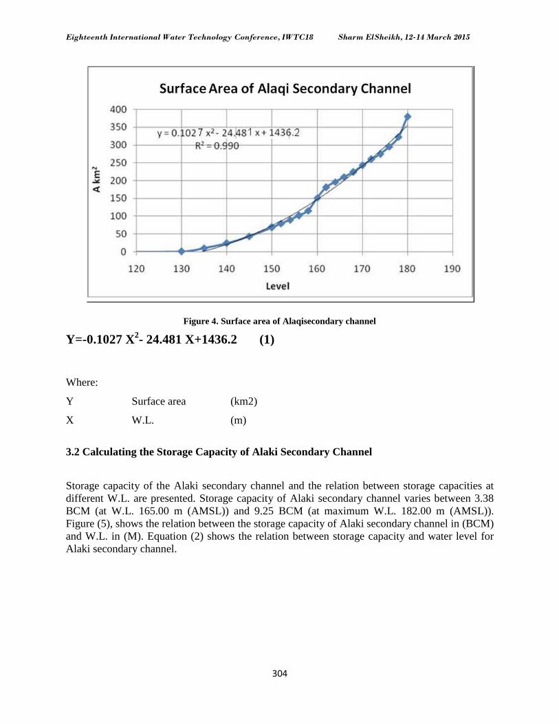
3.1 Calculating Surface Area of Alaki Secondary Channel
Using Multi Beam Technique in hydrographic surveying of Alaki secondary channel,
locations and water depths of Alaki secondary channel bed data (XYZ) were obtained. XYZ data
were incorporated in Surfer to calculate the surface area of Alaki secondary channel at different
W.L. Figure (4) shows the surface area of Alaki secondary channel of Lake Nasser. Equation (1)
shows the relation between surface areas of Alaki secondary channel at different W.L.
Eighteenth International Water Technology Conference, IWTC18 Sharm ElSheikh, 12-14 March 2015
304
Figure 4. Surface area of Alaqisecondary channel
Y=-0.1027 X2- 24.481 X+1436.2 (1)
Where:
Y Surface area (km2)
X W.L. (m)
3.2 Calculating the Storage Capacity of Alaki Secondary Channel
Storage capacity of the Alaki secondary channel and the relation between storage capacities at
different W.L. are presented. Storage capacity of Alaki secondary channel varies between 3.38
BCM (at W.L. 165.00 m (AMSL)) and 9.25 BCM (at maximum W.L. 182.00 m (AMSL)).
Figure (5), shows the relation between the storage capacity of Alaki secondary channel in (BCM)
and W.L. in (M). Equation (2) shows the relation between storage capacity and water level for
Alaki secondary channel.

Eighteenth International Water Technology Conference, IWTC18 Sharm ElSheikh, 12-14 March 2015
305
Figure 5. Storage capacity of Alaqi secondary channel
Y = 0.0022 X2 – 0.5483 X + 33.51 (2)
Where:
Y Storage capacity (BCM)
X W.L. (m)
4. ESTIMATION OF EVAPORATION LOSSES
Evaporation from water surface is a continuous process affected by many meteorological
parameters used in estimation of evaporation losses, the main factors effects on evaporation are
temperature, humidity of the surrounding atmosphere, wind, and atmospheric pressure, all of
these factors can be taken as evaporation rate. One of the most common methods used to
estimate the evaporation losses based on atmospheric elements is bulk aerodynamic method,
equation (3) shows the bulk aerodynamic formulae. It is found that the appropriate coefficient
(N) in equation (3) equals to 0.1296 (Omar, M.H., 1981). Table (3) shows wind and evaporation
rate recorded in one of metrological station in Nasser Lake.
E = N U (es – ed) (3)
E: Evaporation (mm/day)
N: A constant equal to 0.1296
U: The wind velocity at height 2.0 m above water surface (m/sec)
es: A saturated vapor pressure at water temperature (Hectopascal)
ed: A vapor pressure of air 2.0 m above water surface (Hectopascal)

Eighteenth International Water Technology Conference, IWTC18 Sharm ElSheikh, 12-14 March 2015
306
Table 3. Evaporation rate of one metrological station in Nasser Lake
The annual volume of the water lost by evaporation from Alaqi secondary channel was
calculated based on the total yearly average of the evaporation rate from Nasser Lake, where the
yearly average of the daily evaporation rate (E) reached 7.00 mm/day. The annual volume of the
water lost by evaporation can be calculated using equation (4). The annual volume of
evaporation losses from Alaqi secondary channel is about 0.72 billion cubic meters BCM (at
W.L. 175.00 m (AMSL))
V = E * A (4)
E: Yearly average of evaporation rate
A: Surface area
V: Volume
5. PROPOSED SOLUTION
The storage capacity of Alaqi secondary channel is 6.50 BCM (at W.L. 182.00 m AMSL), while
the total storage capacity of High Aswan Dam Lake is 162.00 BCM (at W.L. 182.00 m
(AMSL)). The storage capacity of Alaqi secondary channel is about 4 % of total storage capacity
of High Aswan Dam Lake. The evaporation losses from Alaqi secondary channel is about 0.72
BCM (at W.L. 175.00 m AMSL) while the total evaporation losses from High Aswan Dam Lake
is about 11.98 BCM (at W.L. 175.00 m (AMSL)).The evaporation losses from Alaqi secondary
channel is about 6 % of evaporation losses from Nasser Lake. Because the evaporation losses
from Alaqi secondary channel considered big, so it is proposed to close this secondary channel to
reduce the evaporation losses from Nasser Lake. Also, in case of closing Alaqi secondary
channel, we could consider it as a water tank.
5.1 Closing Dam Location
According to the hydro morphological studies the suitable dam site is located at the hydrographic
surveyed cross section No 15, Figure (2). Using Figure (6) – and 3D bed surface Figure No (8)
help us to allocate the suitable site of closing dam, as it is noticeable that, there is contraction at
the entrance of the Alaki secondary channel at cross section A-A, adding to that, the selected
location lies between the highest elevation topographic points. Figure (6), shows the location of
dam site at cross section A – A.

Eighteenth International Water Technology Conference, IWTC18 Sharm ElSheikh, 12-14 March 2015
307
Figure 6. Location of dam site
5.2The Proposed Dam
A dam is a barrier that impounds water; the reservoirs created by dams do not only suppress
floods but provide water for various needs to include irrigation, human consumption, industrial
and navigation use. According to the hydro morphological studies, the base dam level is at 130 m
(AMSL) and top dam level is at 183 m (AMSL), the designed dam side slope is 2: 1, the
designed dam length at its top is 9247.00 m, while the designed dam width at its top is 8.00 m.
Figure (7) shows the cross section at dam site location, while figure (8) shows the designed dam. Figure 7. Cross section A – A at dam site location

Eighteenth International Water Technology Conference, IWTC18 Sharm ElSheikh, 12-14 March 2015
308
Figure 8. The designed dam
6. CONCLUSIONS AND RECOMMENDATIONS
6.1 Conclusions
Lake Nasser/Nubia studies have been included in many researches to give the required
information to the decision makers about the major water tank for both Egypt and Sudan. Lake
Nasser Has hundreds of secondary channels, one of the largest secondary channels that have
never been surveyed for long time is Alaqi secondary channel. Alaqi secondary channel was
surveyed recently, it is located at about 110 km upstream High Aswan Dam, on the eastern side
of Nasser Lake.
The storage capacity of Alaqi secondary channel is 6.50 BCM (at W.L. 182.00 m (AMSL)), the
storage capacity of Alaqi secondary channel is about 4 % of total storage capacity of Nasser
Lake. The evaporation losses from Alaqi secondary channel are about 0.72 BCM (at W.L.
175.00 m (AMSL)), the evaporation losses from Alaqi secondary channel is about 6 % of
evaporation losses from Nasser Lake. It is proposed to close this secondary channel to reduce the
evaporation losses from Nasser Lake. Finally, it could be concluded that:
Closing Alaqi secondary channel could reduce the evaporation losses from Nasr Lake. The designed dam bed level is 130 m (AMSL), its top level is 183 m (AMSL).
The designed dam length is 9247.00 m at its top and its width is 8.00 m, while its
designed side slope is 2: 1.
Alaqi secondary channel bed material can be classified as medium to fine sand, where its
D50 is equal to 0.17 mm.
The velocity is very low inside Alaqi secondary channel, where the average velocity is
about 0.10 m/s.

Eighteenth International Water Technology Conference, IWTC18 Sharm ElSheikh, 12-14 March 2015
309
Alaqi secondary channel water is clear and fresh because the average value of DO is 8
ppm, TDS value is 150 mg/l and the average value of PH is 7.50.
6.2 Recommendations
Charring out at least one pore hole at dam site for define soil characteristics.
Alaki secondary channel should be kept clear from any random development.
Studying of Alaki secondary channel regarding to fishing, irrigation, navigation, and
recreation areas.
7. NREFERENCES
Abu Atta, A., (1978), "Egypt and the Nile after the High Aswan Dam", Ministry of irrigation, Egypt.
Bob Booth, (2001), "Using Arc GIS 3D Analyst”, copyright 2001, ESRI.
Mohamed I.S. El_Azhary, (2009), "Practical Applications in GIS", Dar Elma'refa, Ain Shams, Cairo,
Egypt.
Nile Research Institute, (2013), "Lake Nasser Secondary Channel Study", Nile Research Institute,
National Water Research Center, Egypt.
Public Authority of High and Aswan Dams, (1973-2011), "Annual Reports of General Department of
Hydrology, Egypt.
RedaM.A.Hassan, Nasr T.H. Hekal, Nader M.S. Mansor, (2007), "EvporationResuction from Lake
Naser Using New Environmentally Save Techniques", IWTC11 2007 Sharm El-Sheikh, Egypt.
Waleed E. Hassan, (2015), "Impacts of Upper River Nile Projects on Lake of High Aswan Dam", Ph
D, Faculty of Engineering, Al-Azhar University, Egypt.