Embed Size (px)
Citation preview

Structure and stratigraphy of Home Plate from the Spirit Mars
Exploration Rover
Kevin W. Lewis,1 Oded Aharonson,1 John P. Grotzinger,1 Steven W. Squyres,2
James F. Bell III,2 Larry S. Crumpler,3 and Mariek E. Schmidt4
Received 19 October 2007; revised 19 March 2008; accepted 14 August 2008; published 13 November 2008.
[1] Home Plate is a layered plateau observed by the Mars Exploration Rover Spirit in theColumbia Hills of Gusev Crater. The structure is roughly 80 m in diameter, and the raisedmargin exposes a stratigraphic section roughly 1.5 m in thickness. Previous work hasproposed a pyroclastic surge, possibly followed by aeolian reworking of the ash, for thedepositional origin for these beds. We have performed a quantitative analysis of thestructure, stratigraphy, and sedimentology at this location. Our results are consistent withan explosive volcaniclastic origin for the layered sediments. Analysis of beddingorientations over half of the circumference of Home Plate reveals a radially inwarddipping structure, consistent with deposition in the volcanic vent, or topographic drapingof a preexisting depression. Detailed observations of the sedimentology show that grainsorting varies significantly between outcrops on the east and west sides. Observationson the western side show a well-sorted population of sand sized grains which comprise thebedrock, while the eastern margin shows a wider range of grain sizes, including somecoarse granules. These observations are consistent with primary deposition by apyroclastic surge. However, aeolian reworking of the upper stratigraphic unit is not ruledout. Identification of explosive volcanic products on Mars may implicate magmainteraction with subsurface hydrologic reservoirs in the past.
Citation: Lewis, K. W., O. Aharonson, J. P. Grotzinger, S. W. Squyres, J. F. Bell III, L. S. Crumpler, and M. E. Schmidt (2008),
Structure and stratigraphy of Home Plate from the Spirit Mars Exploration Rover, J. Geophys. Res., 113, E12S36,
doi:10.1029/2007JE003025.
1. Introduction
[2] The Mars Exploration Rover Spirit saw limited expo-sures of bedrock, and very few layered rocks for the firstseveral hundred sols of its mission [Squyres et al., 2004a].This underscored the significance of the first images at closerange of a formation named ‘‘Home Plate,’’ which revealedextensive outcrops of clearly stratified bedrock. Home Plate(located at 14.64�S, 175.53�E) was first identified fromMars Orbiter Camera (MOC) images as a target of interestbased on its light-toned appearance compared to the sur-rounding soil and rocks of the Columbia Hills, where Spirithas spent the latter part of her mission. From orbital images,Home Plate stands out as the largest expanse of lightertoned material in the Inner Basin of the Columbia Hills.Among sites visited by Spirit, Home Plate is unique,although a few smaller bright features in the Columbia
Hills seen from orbit may be analogous. From rover images,Home Plate is a subcircular plateau, up to a few meters highin places, composed of stratified sedimentary rocks [Squyreset al., 2007]. The sedimentary sequence here exhibitsseveral units, each characterized by distinct morphologies.Several possible interpretations were consistent with initialobservations, including fluvial, aeolian, and volcaniclasticdeposits. Detailed observations were conducted to helpaddress these competing possibilities, all of which canexhibit similar morphologies and can be difficult to distin-guish even on Earth. Each possibility, however, would havedistinct implications for the local geologic history. Theorigin of this enigmatic deposit is addressed here usingquantitative structural and morphological techniques, pro-viding complementary information to the chemical andmineralogical analysis suite of the MER Athena payload.Stereo images from both the engineering and sciencecameras are used to assess the internal structure of thebedding exposed at Home Plate in a quantitative manner. Incombination with sedimentological and stratigraphic obser-vations, these data constrain the potential hypotheses regard-ing the origin of this unique landform, ultimately determinedto be volcaniclastic in origin. Hydrovolcanic features andpyroclastic deposits have been identified elsewhere on Marsbased on orbital data [Hynek and Phillips, 2003;Wray et al.,2008; Jaeger et al., 2007], and modeling has been carriedout to understand the formation of such deposits [Wilson
JOURNAL OF GEOPHYSICAL RESEARCH, VOL. 113, E12S36, doi:10.1029/2007JE003025, 2008ClickHere
for
FullArticle
1Division of Geological and Planetary Sciences, California Institute ofTechnology, Pasadena, California, USA.
2Center for Radiophysics and Space Research, Cornell University,Ithaca, New York, USA.
3New Mexico Museum of Natural History and Science, Albuquerque,New Mexico, USA.
4Department of Mineral Sciences, National Museum of Natural History,Smithsonian Institution, Washington, D. C., USA.
Copyright 2008 by the American Geophysical Union.0148-0227/08/2007JE003025$09.00
E12S36 1 of 16

and Mouginis-Mark, 2003; Wilson and Head, 2004, 2007].Home Plate offers the first ground truth example for refiningand testing these predictions in situ. While the origin ofHome Plate has implications for the geologic history of thislocation, particularly regarding the role of localized, explo-sive volcanism within Gusev crater, the observations andtools presented here may also aid in the interpretation ofsimilar deposits elsewhere on the planet. Specifically, atechnique for robust plane fitting from rover stereo imagesis described here, and may applicable to future remotegeological investigations.
2. Regional Setting
[3] Spirit landed on 4 January 2004 in Gusev crater, a150 km diameter impact crater in the southern highlands ofMars. This landing site was selected primarily because of itsassociation with Ma’adim Vallis, the main trunk of a largevalley network that breaches the southern rim of the crater.This association suggests the possibility of a standing bodyof water at some time in the Martian past [Grin and Cabrol,1997]. In addition to fluvial landforms, a notable feature ofthe regional geology is Apollinaris Patera, a large volcano250 km to the north, indicating volcanism also had asignificant presence in this region of Mars [Robinson etal., 1993; Martınez-Alonso et al., 2005]. Indeed, uponSpirit’s landing, the plains around the rover were found tobe uniformly basaltic in composition [McSween et al., 2004;Arvidson et al., 2006; Morris et al., 2006]. After thoroughlycharacterizing the basaltic rocks of the Gusev plains, Spiritundertook a traverse to the Columbia Hills, in search ofwhat appeared from orbit to be older geologic units and newlithologies. This small area of higher terrain is isolatedamong the otherwise flat topography of the plains. In orbitalimages, the basaltic plains clearly embay the older hills[Crumpler et al., 2005]. Although the process that upliftedor emplaced the hills remains unknown, they may beremnants of the intersection of multiple crater rims, orremnants of the Gusev crater central peak [McCoy et al.,2008]. Within this new terrain, Spirit has found new classesof rocks, evidence of aqueous alteration, and the firstsedimentary rocks of the mission [Squyres et al., 2006].[4] After climbing Husband Hill, Spirit descended roughly
70 m into the Inner Basin of the Columbia Hills (Figure 1).In this area, Home Plate is one of the more prominentgeologic structures, and appears to contain the largestexpanses of bedrock. Several topographic ridges surroundHome Plate, and may be genetically related. These includeMitcheltree Ridge to the east, and Low Ridge to the south.These ridges contain smaller outcrops of layered rock, andare capped by large, and often vesicular basaltic rocks. Thestratigraphic relationship of these ridges to Home Plateremains unclear.
3. Home Plate Observational Campaign
[5] Because of the approaching winter and decliningpower levels, Spirit conducted an initial survey of HomePlate over the course of roughly 26 sols. Spirit firstapproached Home Plate on sol 748, at the northwest cornerof the structure, after descending from Husband Hill. Theoutcrop at this location is the thickest and most diverse
stratigraphic section observed at Home Plate to date. At thislocation, Spirit analyzed the target ‘‘Barnhill’’ on theoutcrop, and also a float rock, ‘‘Posey’’. After this initialsurvey, Spirit drove to the top of Home Plate to gain a bettervantage point for imaging the entire structure. In addition,Spirit carried out two analyses using its Instrument Deploy-ment Device (IDD), on the targets ‘‘Stars’’ and ‘‘Craw-fords’’. Following the in situ campaign, Spirit undertook aclockwise traverse, imaging prominent outcrops betweendrives. This traverse continued through sol 774, when Spiritleft Home Plate to find a favorable location for winteroperations. Spirit’s departure at the Eastern side of thestructure completed a survey of roughly one third of thecircumference of Home Plate.[6] After a mobility hiatus during the Martian winter,
Spirit returned to Home Plate, and conducted an extensivecampaign along the southeastern margin of the structure.This included both close range remote sensing along theoutcrop, as well as a set of nine in situ observations of thecross-bedded rocks on the eastern margin. Together, thesetwo analysis campaigns cover roughly half of the HomePlate margin, providing an extensive data set for interpret-ing its origin and context within the Inner Basin.
4. Stratigraphy
[7] Bedrock outcrops along the margin of Home Platereveal a diverse stratigraphic sequence. Several distinctmorphologies have been observed, which can be delineatedinto distinct geologic units. Chemically and mineralogically,these units are very similar, and comprise the Barnhill rockclass. Further, all of the units at Home Plate have similarmajor element compositions to nearby vesicular basalticrocks of the Irvine rock class [Schmidt et al., 2008]. The twobasic units identified at Home Plate include a planar-beddedto massive lower unit, and a cross-bedded upper unit. Anintermediate layer between these serves as a useful markerbed for correlating outcrops. No exposed contact has beenobserved at the base of this section, and the nature of theunderlying material is unknown.
4.1. Lower Unit
[8] The northwest margin of Home Plate contains themost complete section observed to date, including the bestexposures of the lower stratigraphic unit. The lowest unit inthe observed depositional sequence is characterized by thickbeds which are planar and parallel over several meters(Figure 2, bottom right). In Microscopic Imager (MI)images of this unit, a knobby texture is apparent, thoughit is difficult to tell whether these are original clasts ordiagenetic textures. In the only clear exposure of the lowerunit on the northwest corner, the bedding has been erodedback into nearly planar outcrops. There is some variation inphysical strength between beds, as some tend to formledges, while others are recessed. This pattern indicatesvariable depositional conditions throughout the lower unit.While this characteristic does not discriminate unambigu-ously between depositional processes, it is consistent with apyroclastic deposit, which can show rapid fluctuations ingrain size, sorting, and induration between beds [Crowe andFisher, 1973].
E12S36 LEWIS ET AL.: STRUCTURE AND STRATIGRAPHY OF HOME PLATE
2 of 16
E12S36

[9] Within the lower unit, an apparent bomb sag has beenidentified from Pancam images (see Figure 2, bottom right)[Squyres et al., 2007]. On Earth, bomb sags are typicallyassociated with volcaniclastic deposits, where outsizedclasts thrown out of an explosive vent are emplacedballistically into an otherwise fine-grained ash deposit.The high-energy impact causes disruption and deformationof the underlying layers [Fisher and Schmincke, 1984]. Inthis area, the strata of the lower unit appear to curve beneatha clast several centimeters wide, which is embedded withinthe outcrop. Topographic measurements were made toevaluate whether the apparent curvature in the bed associ-ated with this clast is truly a topographic depression, asopposed to an effect of the outcrop and viewing geometries.Stereo data acquired at close range to the bomb sag indicate
that the layer does deflect roughly 2 cm downward from anotherwise linear exposure in the vicinity of the bomb. Thisobservation supports the case for a bomb sag in the lowerunit of Home Plate, and an explosive origin for the clastswhich comprise it.[10] At the top of the lower unit, a transition to a massive
facies occurs, as shown in the stratigraphic section (Figure 2,middle right). The change from planar-stratified to massivefacies is gradual, with the prominent bedding at the bottomof the unit becoming less distinct, and eventually disappear-ing. It was not possible to extract any structural informationfrom this part of the unit, although it appears to beconformable with the planar-bedded section beneath it. MIimages of this massive section show a texture similar to theplanar beds, with nodular textures, but no clearly identifi-
Figure 1. Map of the Inner Basin of the Columbia Hills, where Spirit has been conducting operationsfor the latter half of her mission. Home Plate stands out as a subcircular light-toned platform roughly 80 min diameter. Topographic measurements indicate a dip of 3–4� to the northwest for the surface ofHome Plate. Several small ridges are situated immediately around Home Plate, including MitcheltreeRidge to the east and Low Ridge to the south. The dark feature near the top of the image is a modernaeolian dune field known as El Dorado. Contours at 2 m intervals are derived from stereogrammetryusing HiRISE images PSP_001777_1650 and PSP_001513_1655 (image credit NASA/JPL/University ofArizona).
E12S36 LEWIS ET AL.: STRUCTURE AND STRATIGRAPHY OF HOME PLATE
3 of 16
E12S36

Figure
2.
Stratigraphic
columnofHomePlate
outcrops,withrepresentativeexam
ples.Theprimarydivisionisbetween
thelower
unit,whereplanar
bedded
andmassivefacies
areobserved,andtheupper
unit,dominated
bycross
stratification.
Thepresence
ofaputativebombsagin
thelower
unitpointsto
anexplosivevolcanic
origin
fortheHomePlatesedim
ent.
Ontheeast
sideofHomePlate,thelower
unithas
notbeenidentified,althoughacorrelationis
indicated
betweena
prominentlayer
seen
atthebaseoftheupper
unitat
both
locations.After
correctingfortheaveragestructuraldip
onboth
thewestandeastsides
ofHomePlate,thestratigraphicthicknessoftheupperunitiscalculatedto
besimilar
towithin
10cm
betweenoutcrops.Thesidepanelofeach
columnindicates
theprojected
internalstructure,whichdipstowardthecenterof
HomePlateateach
locationvisited
bySpirit.Exam
plesofeach
unitareindicated
totheright.Eachim
ageontherightisa
Pancam
falsecolorstretchusingfiltersL2,L5,andL7(753,535,and432nm,respectively).Im
agenumbersare(top)
2P228456914EFFAS6MP2440L2M1;(m
iddle)2P192944022EFFAO55P2275L2M1;and
(bottom)
2P193032914EF-
FAO55P2276L2M1.
E12S36 LEWIS ET AL.: STRUCTURE AND STRATIGRAPHY OF HOME PLATE
4 of 16
E12S36

able grains. This part of the lower unit is roughly 10 cmthick, as shown in the stratigraphic column in Figure 2. Asindicated in Figure 2, the lower unit has not been clearlyidentified on the eastern side of Home Plate. It is likelyobscured by modern aeolian cover, but may simply not havebeen preserved (or ever deposited) in the section here. Acorrelation may exist with other rocks exposed on the eastside between Home Plate and Mitcheltree Ridge, althoughpoor exposures have prevented a conclusive determination.
4.2. Upper Unit
[11] The upper unit of Home Plate accounts for themajority of the vertical section, roughly 90 cm out of 1.3 mon the northwestern corner. This unit is thin bedded, withcharacteristic low-angle cross bedding occurring throughoutthe section and at least one location with high-angle crossbedding on the eastern edge (Figure 2, top right). The upperunit exhibits fine stratification, with individual strata typi-cally a few millimeters in thickness. Two competing hypoth-eses have been proposed for the upper unit of Home Plate[Squyres et al., 2007]. In the first interpretation, the upperunit is conformable with the lower unit, deposited in a laterstage of the same pyroclastic surge. Cross stratification,often referred to as a ‘‘sand wave’’ facies in the case ofvolcaniclastic deposits, is a common feature of terrestrial
surge beds [Wohletz, 1998]. Alternatively, the upper unitmay represent material which has been reworked by aeolianprocessing from the same material which comprises thelower unit, being lithified at a later time. Thus, a centralquestion for understanding the origin of Home Plate isdiscerning the depositional environment of the upper unit.[12] Two facies are prevalent within the upper unit of
Home Plate. From the northwestern to the southern cornersof Home Plate, images have been acquired of nearly theentire margin, and in some places repeatedly. Thus, theimage data sets are highly representative of the actualoutcrops at Home Plate. At most locations on the northernand southern perimeter, beds are planar or low-angle strat-ified. Truncation surfaces are typically inclined only a fewdegrees from bedding planes, and occur throughout thesection. This bedding style is not uniquely diagnostic of aparticular depositional mode, and is consistent with eithersurge deposition [Fisher and Schmincke, 1984] or anaeolian sand sheet facies similar to that described at Mer-idiani Planum by Grotzinger et al. [2005].[13] On the eastern margin of Home Plate, large-scale
trough cross bedding dominates the section (Figure 3).Concave upward erosion surfaces are common and extendover meter-scale wavelengths. Bed sets within this faciescontain strata that parallel or asymptotically approach ero-
Figure 3. One example of high-angle cross bedding observed at Home Plate, from sol 1150. Aninterpreted sketch is shown the lower inset, with erosional boundaries between cross-bed sets marked asthick lines with representative cross strata shown as thin lines. At this location, cross strata show aconsistent orientation with respect to bounding surfaces, and bounding surfaces occasionally intersect atlow angles. This suggests a uniform migration direction, which was oblique to the outcrop. The top insetshows one possible bed form reconstruction for this outcrop. The horizontal distance across the lower partof the image is approximately 2 m. The mosaic is a false color stretch, as in Figure 2 (mosaic creditNASA/JPL/Cornell University).
E12S36 LEWIS ET AL.: STRUCTURE AND STRATIGRAPHY OF HOME PLATE
5 of 16
E12S36
sional lower surfaces. Exposed cross-bed sets are typically afew meters in horizontal extent, and tens of centimeters inthickness. It is well established that trough cross bedding isformed by migration of sinuous crested bed forms [Rubin,1987]. However, the link from stratigraphy to specific flowdynamics is less certain. The cross-bed sets on the easternmargin of Home Plate show a consistent orientation betweenbounding surfaces and internal stratification throughout thesection, as shown in Figure 3. For a cross section nearlyperpendicular to the flow direction, trough cross beddingshould show a variety of orientations with respect to erosionsurfaces. For this reason, the flow direction is interpreted tobe oblique to the outcrop orientation at this location.Further, the consistent orientation of the cross beds impliesa uniform migration direction of the bed forms. Thisobservation is consistent either with a pyroclastic surge, oraeolian dunes that generally migrated in one direction. Onepossible bed form reconstruction is shown in Figure 3 (topinset), created using software developed by Rubin andCarter [2006]. In this inset, a sinuous-crested bed form isshown migrating uniformly in a direction oblique to theexposed section. This is a simple formation hypothesis forthe outcrops seen at Home Plate; more complex geometries,particularly ones involving multiple superimposed bedforms, may also be consistent with observed cross-beddinggeometries.
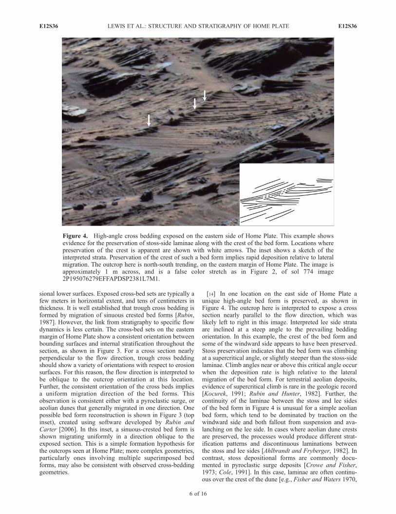
[14] In one location on the east side of Home Plate aunique high-angle bed form is preserved, as shown inFigure 4. The outcrop here is interpreted to expose a crosssection nearly parallel to the flow direction, which waslikely left to right in this image. Interpreted lee side strataare inclined at a steep angle to the prevailing beddingorientation. In this example, the crest of the bed form andsome of the windward side appears to have been preserved.Stoss preservation indicates that the bed form was climbingat a supercritical angle, or slightly steeper than the stoss-sidelaminae. Climb angles near or above this critical angle occurwhen the deposition rate is high relative to the lateralmigration of the bed form. For terrestrial aeolian deposits,evidence of supercritical climb is rare in the geologic record[Kocurek, 1991; Rubin and Hunter, 1982]. Further, thecontinuity of the laminae between the stoss and lee sidesof the bed form in Figure 4 is unusual for a simple aeolianbed form, which tend to be dominated by traction on thewindward side and both fallout from suspension and ava-lanching on the lee side. In cases where aeolian dune crestsare preserved, the processes would produce different strat-ification patterns and discontinuous laminations betweenthe stoss and lee sides [Ahlbrandt and Fryberger, 1982]. Incontrast, stoss depositional forms are commonly docu-mented in pyroclastic surge deposits [Crowe and Fisher,1973; Cole, 1991]. In this case, laminae are often continu-ous over the crest of the dune [e.g., Fisher and Waters 1970,
Figure 4. High-angle cross bedding exposed on the eastern side of Home Plate. This example showsevidence for the preservation of stoss-side laminae along with the crest of the bed form. Locations wherepreservation of the crest is apparent are shown with white arrows. The inset shows a sketch of theinterpreted strata. Preservation of the crest of such a bed form implies rapid deposition relative to lateralmigration. The outcrop here is north-south trending, on the eastern margin of Home Plate. The image isapproximately 1 m across, and is a false color stretch as in Figure 2, of sol 774 image2P195076279EFFAPDSP2381L7M1.
E12S36 LEWIS ET AL.: STRUCTURE AND STRATIGRAPHY OF HOME PLATE
6 of 16
E12S36

Plate 3]. Both the presence of cohesive sediment and rapidfallout from suspension over the whole bed form can allowpreservation of the crest in a surge deposit [Crowe andFisher, 1973]. The observation of a supercritically climbingbed form favors the pyroclastic interpretation for the upperunit, although it is the only example seen thus far at HomePlate.[15] Ideally, details of the cross bedding observed in the
upper unit of Home Plate could provide clues as to thedepositional process that formed it. Cross-bedded sedimentsare most commonly deposited by aeolian or fluvial processeson Earth. However, volcanic surge deposits can also showcomplex cross stratification, and the discrimination betweenprimary surge deposits and those reworked by aeolianprocessing is difficult even in terrestrial settings [Smithand Katzman, 1991]. Very little chemical or morphologicalevidence has been found for fluvial action in the ColumbiaHills [Squyres et al., 2007]. Further, as discussed insection 5, a large fraction of the sediment comprising theupper unit is unresolvable by the MI, implying grain sizesless than 100 mm. As shown in Figure 17 of Grotzinger etal. [2005], dunes are not predicted to form in subaqueousflows on Mars for grain sizes less than �200 mm. However,the aeolian and surge interpretations are both consistent withmany of the observed characteristics. In particular, large-scale trough cross bedding is well documented on Earthin both aeolian deposits [Rubin, 1987; Ahlbrandt andFryberger, 1982] and volcaniclastic surges [Wohletz,1998]. All of the cross bedding seen at Home Plate is atthe �10 cm to 1 m scale or larger. In most cases, bed formsare truncated, indicating larger original heights. No bedforms have been observed at centimeter-scale wavelengths.
4.3. Intermediate Layer
[16] At the northwestern corner of Home Plate, a thin,erosion resistant bed was observed between the upper andlower units (Figure 2, center of middle inset). This bedtypically appears as a doublet of two prominent strata,roughly 2 cm thick in total. The physical strength of thislayer, in combination with its position between two mor-phologically distinct units makes it a useful marker bed forcorrelating outcrops.[17] The intermediate layer cannot be traced continuously
around Home Plate, disappearing particularly on the north-eastern margin. However, a similar unit is observed on thesoutheastern edge of Home Plate. At several locations, anerosion resistant ‘‘fin’’ appears close to the bottom of upper,cross-bedded unit. Further, the bed often appears as adoublet, of similar thickness to that observed on the otherside of Home Plate. The location of this layer at the bottomof the exposed section is also consistent with the disappear-ance of the lower unit on the southeast margin. Thus, thecombined similarity in thickness, stratigraphic position, andmorphology suggest that these strata are correlative over180� of the circumference of Home Plate. The observationof this intermediate layer on both the northwest and south-east sides of Home Plate also requires deposition by aprocess which was uniform over at least tens of meters.
4.4. Home Plate Upper Surface
[18] Observations of the top of Home Plate, which Spiritdrove onto at the northeastern and western margins, show a
heavily fractured, dust covered surface. Several subcirculardust filled depressions are likely remnants of small impactcraters, indicating an ancient surface. Where upper unitrocks are exposed, they have been rotated and displaced,making their stratigraphic interpretation difficult. WhileSpirit has not driven into the center of Home Plate, someexposures of bedrock are continuous and appear to belargely intact from rover and orbital images. This indicatesthat the modern surface is primarily a product of bedrockerosion, rather than infill by aeolian material. In addition,there appear to be localized areas where dark, vesicularbasaltic rocks are scattered around the surface. The strati-graphic position of these rocks relative to the Home Platesequence is unknown, although geochemical results indicatea genetic relationship [Schmidt et al., 2008].[19] Aeolian erosion has left a smooth upper surface to
the Home Plate structure, although a small raised rim existsin some locations, particularly on the southern margin. Thetopography of the upper surface of Home Plate can bequantified using orbital stereo images. We have used HighResolution Imaging Science Experiment (HiRISE) images(image numbers PSP_001777_1650 and PSP_001513_1655)to derive a digital elevation model (DEM) for the ColumbiaHills via the method of Kirk et al. [2008]. From this data set,Home Plate can be adequately approximated by a plane,which dips 3–4� to the northwest (Figure 1). While theupper surface of Home Plate has clearly undergone somedegree of erosion, the magnitude and azimuth are similar tothe surrounding gradient of the Inner Basin, as measuredfrom the same data set. This long-wavelength tilt of theupper surface of Home Plate may reflect draping of thepreexisting topographic slope.
5. Sedimentology
[20] Spirit made observations of several targets at twolocations around the perimeter of Home Plate with theMicroscopic Imager. Three of these targets (Posey, Crawfords,and Stars) were rocks from the upper cross-bedded unit, onthe western side. Stars and Crawfords were both on top ofHome Plate, indicating an origin in the uppermost part ofthe section, although the rocks in this area appear to havebeen rotated and shifted from their original positions. Posey,on the other hand, was clearly out of place, located to theside of Home Plate. Although its exact position in thestratigraphic column cannot be determined, its fine-scalestratification clearly correlates with the character of theupper unit of Home Plate. All of these images were takenroughly parallel to bedding planes. A fourth target on thewest side, Barnhill, was imaged within the lower unit, onsols 747 and 750 (Figure 5). This target was of in-placebedrock at the northwest corner of Home Plate, so itsstratigraphic position is well established. Finally, a set ofseven observations were made on the east side of HomePlate, with five in the upper unit, and two on the interme-diate fin layer. All of the east side targets were in place inthe outcrop, and most were perpendicular to bedding planes,exposing a sequence of strata.[21] Figure 5 shows an MI image of the lower unit target
Barnhill. While the lower unit of Home Plate is stratified atcentimeter scales, it is massive at smaller scales. Further,there is little evidence of individual clasts within this rock.
E12S36 LEWIS ET AL.: STRUCTURE AND STRATIGRAPHY OF HOME PLATE
7 of 16
E12S36

The lack of a clastic texture suggests either that thesediment size is largely below the resolution of the MI (lessthan 100 mm), or that diagenetic or weathering processeshave obscured the original clastic texture. The latter inter-pretation is supported by the knobby texture seen in somelower unit rocks, as shown in Figure 5. When they can bemeasured, these roughly equant knobs are of a coarse tovery coarse sand size (roughly 1 mm in diameter, orbetween 1 and �1 on the f scale).[22] In contrast to the lower unit, MI images of upper unit
rocks show abundant dark clasts typically hundreds ofmicrons in diameter, and up to nearly 3 mm for the largestexample (Figure 6d). In some cases, the rocks appear to beclast supported, as in the case of Crawfords, on thenorthwestern side of Home Plate (Figure 6a). However,particularly on the eastern side of Home Plate, a significantvolumetric fraction of the rocks appears to be composed ofmaterial finer than the resolution of the MI (�100 mm[Herkenhoff et al., 2004]), as seen in Figures 6c and 6d. Inthe case of a mature aeolian deposit, material below thisthreshold is often removed by suspension, leaving a well-sorted framework of coarser particles which move bysaltation. This attribute is observed for modern aeoliandeposits imaged by Spirit, one example of which is shownin Figure 6b. This image was taken at the 170 m wide sandsheet known as ‘‘El Dorado’’, to the north of Home Plate(Figure 1). At this location, the apparent lack of finergrained material was also indicated by a lack of sedimentcohesion within a trench dug by the rover [Sullivan et al.,2006]. In contrast, the poorly sorted character of many surgedeposits on Earth is consistent with a large fine-grainedfraction [Smith and Katzman, 1991].[23] The upper unit exhibits several differences in sedi-
mentology between the east and west side of Home Plate.On the west side, grains are highly rounded, appearing to benearly spherical for the largest, best resolved grains. Incontrast, on the east side of Home Plate, grains are more
angular, and occasionally elongated. Grain roundness is animportant characteristic for distinguishing between deposi-tional processes. Very round grains typically indicateextensive transport and abrasion prior to deposition. Anexcellent example is the El Dorado sand sheet, shown inFigure 6b. In contrast, juvenile pyroclasts are typicallyangular, experiencing only minor physical abrasion duringtransport [Wohletz, 1983]. While the rock targets on the westside of Home Plate are strikingly similar to modern aeoliandeposits in terms of roundness, the east side targets are moreconsistent with a limited degree of transport and abrasion.Ultimately, these contrasting observations alternately pro-vide support for either a pyroclastic or an aeolian deposi-tional mechanism for the upper unit.[24] The second important characteristic of the upper unit
clasts is their degree of sorting, which again varies betweenthe two sides of Home Plate. To quantify the sortingcharacteristics, we have measured the diameters of severalhundred grains in selected patches of the MI images foreach of the upper unit targets. In addition, we performed theanalysis on El Dorado, the modern aeolian deposit observedby Spirit earlier in the mission. This was done for compar-ison in recognition of the fact that aeolian deposits aretypically among the most mature sediments found in ter-restrial environments [Prothero and Schwab, 2004].[25] Figure 7 shows a plot of the sediment size distribu-
tion for each of the targets on the west side, along with ElDorado. All of the distributions fall within a very narrowsize range from 100 to 500 mm. The mean grain diametersfor the three Home Plate rocks range from 216 mm forPosey to 313 mm for Crawfords, while the aeolian ElDorado is intermediate at 288 mm. Further, the width ofthese distributions, which gives a measure of the sorting, issimilar. Standard deviations range from 48 mm to 65 mm forHome Plate, while El Dorado falls within these bounds, at56 mm. On the basis of grain size and sorting alone, the clastpopulation found on the west side of Home Plate isindistinguishable from a modern, texturally mature sandsheet. However, pyroclastic deposits are also capable oftransporting sand sized sediment, and physically sorting thesediment to varying degrees [Wohletz, 1983]. From theobservations of the west side alone, the aeolian reworkedhypothesis is favored, but a primary volcaniclastic origincannot be ruled out.[26] On the east side of Home Plate, very different sorting
characteristics are seen. While the distributions from thewest side have a fairly narrow peak around the meandiameter, the east side shows a significant tail of muchcoarser material, and a peak at somewhat finer grain sizes(Figure 8a). The mean grain diameters for these rocks aresimilar to the west side, while the standard deviations areuniformly higher (Figure 8b), consistent with the coarse tailof the distributions. The largest clast found within the crossbedding on the east side was approximately 1.5 by 2.8 mmin size. This diameter is far larger than any observed at ElDorado, the largest of which are under 0.5 mm. It is,however, consistent with the size range of granules thathave been transported by saltation-induced creep in moderneolian deposits on Mars [Jerolmack et al., 2006]. Thesegranules can form small low-relief bed forms known asgranule ripples, and have been observed at both roverlocations [Greeley et al., 2004]. Of course, large clasts are
Figure 5. Unbrushed surface of Barnhill, a target withinthe lower unit of Home Plate, taken on sol 750. The view is3 cm across. Image 2M192958525FFLAO55P2977M2M1.
E12S36 LEWIS ET AL.: STRUCTURE AND STRATIGRAPHY OF HOME PLATE
8 of 16
E12S36

common in pyroclastic surge deposits, and can be emplacedas part of the surge cloud, or ballistically for the largestclasts.[27] Together, the textural evidence on the east side of
Home Plate paints a picture that is the inverse of thesituation on the west side: on the east side, a pyroclasticsurge origin is favored, but aeolian reworking cannot beruled out. While observations have illuminated a spatialheterogeneity to the upper unit of Home Plate, it is clear thatthe cross-bedded outcrops are all part of a single unit, whichis expected to have formed via a single process. There is nocompelling evidence to suggest multiple processes arerequired to produce different parts of the upper unit, or thatonly part of the section may have undergone aeolianreworking.
6. Structure
6.1. Method
[28] We have used topographic data derived from stereoimages to make precise structural measurements of the
stratified materials at Home Plate. The Panoramic Camera(Pancam) is the primary science imaging tool onboard theMER rovers. This pair of cameras is capable of taking stereoimages with a 30 cm baseline in both red and blue wave-lengths [Bell et al., 2003]. From Pancam image pairs, rangeand topographic data can be derived out to 100 m or morefrom the rover [Squyres et al., 2003]. To a lesser extent, wehave also made use of stereo images from both the Navi-gation Camera (Navcam), and the Hazard Avoidance Cam-eras (Hazcams). Image pairs are taken specifically forstereogrammetry, and topographic data is derived via theautomated software pipeline maintained by NASA’s Multi-mission Image Processing Lab (MIPL) [Maki et al., 2003;Alexander et al., 2006].[29] Strata were first traced manually from the original
images, and the corresponding topographic data was sub-sequently extracted. Layers which could be followed over asignificant fraction of the image (typically greater than 75pixels), and which had a natural three-dimensional topog-
Figure 6. MI views of Home Plate upper unit rock targets (Crawfords, Mildred Deegan, and ElizabethEmery), compared with the modern El Dorado dune field also observed by Spirit. In the rock Crawfords,a consistent population of well-rounded and -sorted clasts are observed. This population is nearlyidentical to that observed at El Dorado, both in terms of shape and sorting. However, on the east side ofHome Plate, images of the lower two rock targets show a more poorly sorted texture, with severaloutsized clasts. The largest clast, from Elizabeth Emery, is nearly 3 mm in diameter. Aeolian activitycannot transport grains of this size by saltation on Mars (although saltation-induced creep may bepossible), giving weight to the primary pyroclastic surge interpretation for the upper unit. Each image is asubframe 1 cm across. Image numbers are 2M194100679EFFAODQP2936M2M1, 2M189317855EF-FAL00P2956M2M1, 2M234495019EFFATF3P2936M2M1, 2M234405984EFFATF3P2936M2M1.
E12S36 LEWIS ET AL.: STRUCTURE AND STRATIGRAPHY OF HOME PLATE
9 of 16
E12S36

raphy in the outcrop worked best for this analysis, so effortswere made to select layers which exhibited these qualities.[30] A best fit plane is calculated for each layer using
linear regression to minimize the residuals in the orthogonaldirection. From the best fit plane, the strike and dip arecalculated, along with their corresponding errors. Spiritconducted an extensive though rapid imaging campaign asit circumnavigated the northern and eastern sides of HomePlate. The data used in this analysis are from site 124position 55, site 125 positions 38, 100, and 218, and site129 positions 25 and 262 (Figure 9). These sites werechosen on the basis of their well-exposed outcrops of intactbedrock, and the suitability of the images for this analysis.Measurements were made for both the planar-bedded lowerunit and the cross-bedded upper unit of Home Plate.However, measurements of the upper unit were only takenin areas of low-angle cross bedding, in order to elicit larger-scale structural information, rather than bed form signatures.Retrieved bedding orientations mostly show dip angles
higher than that exhibited by the cross bedding, affirmingthat this was the case.[31] Mathematical criteria are used to select only those
layers which provide a well-constrained planar fit. Principalcomponent eigenvalues describe the variance in threeorthogonal directions, both within the plane (first and secondcomponents), and out of the plane (third component). Thefirst criterion limits the percentage of the variance in thefirst principal component to less than 99.5%. This preventslayers for which the topography is too linear to adequatelyconstrain the second dimension from being included infurther analyses. The second criterion requires the ratio ofthe variance described by the second principal component tothat of the third to be greater than 15, ensuring that thesignal which describes the planar fit is significantly largerthan the out-of-plane error in the data. These empiricalvalues were found to reliably exclude poorly constrainedmeasurements. The range to the outcrop was less than 5 m
Figure 7. (a) Percent grain size distribution for three upper unit rocks from the west side of Home Plate,compared to a modern sand sheet (El Dorado), also observed by Spirit. The four distributions are verysimilar, demonstrating the high degree of sorting of the sediment which comprises the upper unit. Binsize is 50 mm. (b) Mean grain diameter plotted against the standard deviation of the grain size population.Again, Home Plate clasts exhibit textural maturity comparable to modern aeolian sediment.
E12S36 LEWIS ET AL.: STRUCTURE AND STRATIGRAPHY OF HOME PLATE
10 of 16
E12S36

at each of the imaging positions, and noise was typicallyunder 1 cm in amplitude.
6.2. Results
6.2.1. Lower Unit[32] The lower unit of the stratigraphy was best imaged at
the northwestern corner of Home Plate, and this was theonly location suitable for structural analysis. Overall, thelower unit appears to have low resistance to physicalerosion, and primarily erodes back into nearly planar out-crops. Such small topographic variation renders much of theunit unsuitable for this study, due to the inability to uniquelydetermine the three-dimensional attitude from a linearexposure. Only one area, on the rock Barnhill, had suitablesurface topography to allow derivation of the dips within thelower unit. The images of Barnhill best suited to thisanalysis were from Spirit’s Front Hazcam on sol 751. Fromthis area, six bedding traces were extracted which were wellfit by planes. The dip azimuth of these beds is uniformly
southeast. The mean dip angle for the whole data set wasfairly steep at 26�, with the steepest being over 36�. Thelower unit bedding attitudes are nearly identical in strike,but have slightly higher dips compared to the upper unitstrata directly above them.6.2.2. Intermediate Layer[33] On the east side of Home Plate, the erosion resistant
layer immediately below the upper unit is exposed parallelto bedding in several places. Where images are available atclose range, it is possible to tightly constrain the structure.Here, we made 7 measurements of the bedding whichshowed excellent agreement in attitude. For this layer, themean azimuth was N74�W, roughly radial to Home Plate,with a standard deviation of only 3�. The dips within thisunit are the steepest measured at Home Plate, ranging from33 to 42�, with a mean of 36�. This result is significant inthat it lies at or above the angle of repose, where drysediment becomes unstable to avalanching.
Figure 8. (a) Percent grain size distribution for all measured upper unit rocks on the east and west sidesof Home Plate. The east side rocks show a long tail of coarser grains out to over 2 mm, and a peak atsmaller grain sizes. Bin size is 25 mm. (b) Mean grain diameter plotted against the standard deviation ofthe grain size populations. This plot demonstrates the relatively poorer sorting of the east side rocks(unfilled markers) compared to the west side (gray markers). The modern aeolian deposit El Dorado isalso included for comparison.
E12S36 LEWIS ET AL.: STRUCTURE AND STRATIGRAPHY OF HOME PLATE
11 of 16
E12S36

6.2.3. Upper Unit[34] The upper unit of Home Plate is particularly well
suited to the structural topographic analysis described here,due to characteristic erosional patterns. In many places, thisunit has eroded to form undulating surfaces and �10 cmscale spurs which project out of the outcrop face. This
surface relief allows well-constrained measurements of thethree-dimensional bedding structure.[35] Imaging at each of the four locations mentioned
above provided adequate topography for structural measure-ments of the upper unit. A total of 93 measurements wereused in this analysis from all of the sites.
Figure 9. Structural data for Home Plate, at each of the sites visited by Spirit. For each of the locationsindicated on the map, the corresponding rose plot shows dip azimuths of the measured beds. The blackarrow on each plot shows the average orientation of the associated outcrop face to demonstrate that theyare not correlated with the fitted bedding planes. (a) Measurements within the upper unit, for fivelocations around the circumference. Together, these plots depict the radial inward dipping structure foundat Home Plate over nearly half of its circumference. The base map is an orthogonal projection of HiRISEimage PSP_001513_1655; north is up. (b) Results for the lower unit, taken on the northwest corner, andthe intermediate ‘‘fin’’ layer, taken on the eastern margin. These dip azimuths show excellent agreementwith the overlying strata of the upper unit. (c) Histograms of the overall dip magnitudes for the upperunit, and the lower unit together with the intermediate layer which shows similar dip magnitudes. Thegenerally smaller dips of the upper unit relative to underlying strata implies a shallowing trend withincreasing height in the stratigraphic section.
E12S36 LEWIS ET AL.: STRUCTURE AND STRATIGRAPHY OF HOME PLATE
12 of 16
E12S36

[36] Overall, the dip magnitudes within this part of thestratigraphic section range from roughly 0–35�, with a 1-srange of 5–25�. Dip azimuths vary widely between out-crops, although they exhibit a consistent trend at eachindividual location. Azimuths overwhelmingly trend south-east at the first site visited by Spirit, on the northwesterncorner of Home Plate, as shown in Figure 9. This orienta-tion projects roughly into the outcrop at this location, radialto the Home Plate structure. Here, a large number of bedscould be analyzed because of thorough imaging at closerange which minimizes noise in the topographic data. At thesecond and third outcrops along the northern edge, Site 125,positions 38 and 100, similarly consistent trends were founddespite the fewer number of usable layers. At both of theselocations, dip directions were uniformly southwest, whichagain corresponds to the direction toward the center ofHome Plate. At the fourth and fifth sites on the easternmargin, strata dip westward and northwestward respectively,again both in the radial direction.[37] The upper unit of Home Plate exhibits ubiquitous
cross stratification, which complicates structural measure-ments. However, all of the measurements were made inareas of low-angle cross bedding to minimize this effect. Atthe first outcrop, where the most measurements were made,layers showed a mean slope perpendicular to the overalltrend of less than 3�, up to a maximum of only 8�. The factthat the variability induced by cross stratification is small isalso shown simply by the tightness of the calculateddistributions around a mean dip direction, as illustrated byFigure 9.
7. Discussion
[38] The most consistent hypothesis for the origin ofHome Plate includes rapid deposition of material by apyroclastic surge, followed by possible aeolian reworking.Evidence of ballistic ejecta in the form of a bomb sag, andsteeply inclined strata with variable bedding and grainsorting characteristics are consistent with such a high-energy process. While an impact event could also producea surge with similar deposits, chemical evidence, mostnotably the lack of Ni enrichment, makes this a lessfavorable scenario, as discussed by Squyres et al. [2007].The presence of abundant vesicular basaltic rocks in thearea further strengthens the case for a volcanic origin.
7.1. Structure and Origin of Home Plate
[39] One of the most striking characteristics of HomePlate is its bowl-shaped internal structure. Any depositionalmodel must take account of this unusual attribute. Onepossible interpretation is that Home Plate is itself thevolcanic vent which supplied the material for the observeddeposits. Terrestrial analogs include tuff rings and maarvolcanoes, both low-relief hydrovolcanic edifices whichoften exhibit surge deposits. In this case, the localizednature of the Home Plate materials can be accounted for,as proximal deposits are thicker and more volatile-enhancedthan distal beds, and therefore more likely to be preserved.Both the bomb sag in the lower unit and the cross beddingof the upper unit further implicate a source proximallocation [Wohletz, 1998]. Although it is difficult to put aquantitative constraint on the vent distance from a single
bomb, ballistic modeling by Wilson and Head [2007] for aclast of this size strongly suggests a local source withinGusev crater, perhaps within a few kilometers. On the otherhand, the lack of additional large ejecta blocks along withthe well-sorted nature of the clastic rocks seen at somelocations imply a degree of physical sorting which is notlikely to be found at proximal locations, suggesting HomePlate itself is not the volcanic source. In addition, the size ofHome Plate is at the very lower limit for tuff rings or maarson Earth, which are more typically hundreds of meters tokilometers in scale [Cas and Wright, 1987]. Home Plate isonly 80 m in diameter, and potentially analogous deposits inthe Columbia Hills are even smaller. Finally, the observa-tion of bed forms interpreted to be oblique or nearly parallelto flow direction, as in Figures 3 and 4, is unexpected giventhe radial outward flow direction implied if the center ofHome Plate is the volcanic source and the cross bedding isprimary. If the upper unit has been reworked by the wind,the flow direction does not provide information about thevent location.[40] While it remains possible that the center of Home
Plate is the vent which produced the stratified material, ourfavored interpretation for the radial structure is depositionby a volcanic surge into a preexisting depression, mostlikely an impact crater. Surge deposits are well known todrape underlying topography and thicken in topographiclows [Reading, 1996]. Further, they are capable of overrid-ing rough topography, and even traveling up topographicslopes [Crowe and Fisher, 1973; Waters and Fisher, 1971].In this case, the thin surge beds could have been strippedaway from most flat-lying areas, but remain protectedwithin a natural depression. The rim of the preexistingimpact crater could have been eroded before or afterdeposition by the pyroclastic surge, consistent with observedcrater degradation seen elsewhere at Gusev crater [Grant etal., 2005]. Infilling by pyroclastic material is consistent withboth the steepness and upward shallowing of dips observedfrom the lower unit and intermediate layer to the upper unit.Evidence of topographic draping has also been found on theridges surrounding Home Plate and on Husband Hill,directly to the north [Lewis et al., 2007; Crumpler et al.,2006]. Deposition in a fresh, primary crater of this diameterwould imply a maximum thickness up to �16 m for theHome Plate material [Melosh, 1989], although depth meas-urements of similarly sized degraded craters on the Gusevplains suggests a few meters maximum thickness to be morelikely.
7.2. Origin of Upper Unit Cross Bedding
[41] While the lower unit of Home Plate is likely to be aprimary surge deposit, the cross-stratified upper unit ofHome Plate may have undergone aeolian reworking andlater lithification. The structural attributes of the upper unitare most consistent with a primary volcaniclastic origin. Theinward dipping, bowl shape of the unit can be explained bydraping of a topographic depression, as inferred for thelower unit. No evidence for a depositional hiatus in the formof an angular unconformity has been found at the base ofthe upper unit on either side of Home Plate, from structuralor morphologic observations. Dip measurements of theunderlying units average 25� for the west side and 35� forthe east side. Particularly on the east side where strata are
E12S36 LEWIS ET AL.: STRUCTURE AND STRATIGRAPHY OF HOME PLATE
13 of 16
E12S36

steepest, formation of aeolian dunes on a substrateapproaching the angle of repose is unlikely. Pyroclasticsurges in contrast are capable of overriding topographicobstacles and depositing material on steep uphill slopes,particularly when the ash cloud has a higher fraction ofentrained water to increase cohesion [Cas and Wright, 1987;Cole et al., 2001]. Postdepositional compaction of thesediment alone cannot explain the observed magnitude ofthe radial dips, requiring a volume loss of tens of percent. Inthe case that Home Plate is itself the volcanic vent,evacuation of the magma chamber, and to a lesser extentthermal contraction, could provide additional inward col-lapse and rotation of the overlying sediments.[42] Sedimentological observations suggest varying
degrees of physical processing for the sediment populationwhich comprises the upper unit of Home Plate. Images fromthe east side show several millimeter-size particles, and oneclast nearly 3 mm in length. The coarse tail of the grain sizedistribution seen at this location (Figure 8) is more consis-tent with a pyroclastic origin, although the grains are notlarge enough to rule out aeolian transport by saltation-induced creep. In contrast, observations on the west sideshow a narrow size distribution of particles, with a similarsize range to that observed at the El Dorado sand sheet(Figure 7). The well-rounded shape of many clasts on thewest side suggests extensive transport and abrasion, aswould be expected in an aeolian environment. We cannotrule out the possibility that a fraction of the upper unit iscomposed of accidental material that was already roundedand sorted before being swept into a pyroclastic surge.Hydrovolcanic deposits often include a large portion ofmaterial which is derived from preexisting country rock[Ollier, 1967; Lorenz, 1973]. However, the chemical simi-larity to both the lower unit and nearby vesicular basaltssuggests that the upper unit material is derived from acommon source [Squyres et al., 2007; Schmidt et al.,2008]. In summary, structural and sedimentological obser-vations from the east side are supportive of a primarypyroclastic origin for Home Plate. On the west side,however, the observed sedimentology suggests aeolianreworking of pyroclastic materials. Future observationsmay help resolve this issue. In particular, observations ofoutsized clasts in the upper unit could constrain its genesis.[43] Finally, it is notable that no examples of centimeter-
scale cross bedding have been found within the upper unitof Home Plate. The discovery of these small-scale bedforms within the bedrock at the Opportunity rover landingsite has been critical in establishing the dune-interdunedepositional model for the bedrock at that location [Squyreset al., 2004b; Grotzinger et al., 2005]. The occurrence ofthese bed forms at Meridiani Planum has been put forwardas a unique indicator of subaqueous, rather than subaerialflow. In contrast, the lack of similar features at Home Plateis consistent with the interpretation of purely subaerialtransport, either within a pyroclastic surge, or by aeolianprocesses.
7.3. Implications of a Pyroclastic Surge Deposit atGusev Crater
[44] The discovery of a preserved volcaniclastic depositwithin Gusev crater sheds new light on the geologic historyof this location. A common source of explosive volcanism
arises from interaction of hot magma with a water reservoir.Particularly for small, basaltic sources such as that inferredfor Home Plate, explosions typically result from rapidvaporization of surface or subsurface hydrologic sources[Wohletz, 1998; Cas and Wright, 1987]. While there is littleevidence to suggest large amounts of water at the surface inthe vicinity of Home Plate, the existence of a groundwaterreservoir at the time of formation could have provided thenecessary trigger for a phreatomagmatic explosion. In thisscenario, the very existence of Home Plate may implicatesubsurface water in the ancient past, a reservoir which isotherwise difficult to assess.[45] In addition, the preservation of the Home Plate
deposits through lithification provides information aboutaqueous interaction at this location. The rocks at HomePlate have been eroded to a large degree, and the paucity ofloose rocks from the Home Plate sequence suggests poorresistance to physical abrasion. In the event that Home Plateis a primary volcaniclastic deposit, induration could haveoccurred nearly contemporaneously with deposition. If thecross bedding of the upper unit represents aeolian reworkingof the pyroclastic material, lithification would have to haveoccurred some time after the volcanic explosion. In eithercase, water is the most likely mechanism for cementingloose ash particles into coherent rock. Indeed, chemical andmineralogical evidence suggests significant hydrothermalaction at Home Plate and within the Inner Basin of theColumbia Hills [Schmidt et al., 2008]. The formation ofmany terrestrial sedimentary rocks is aided by burial andcompaction. Similarly, the thick section of sulfate bedrockof Meridiani Planum shows evidence for extensive deflationincluding crater degradation and a widespread lag of hema-tite grains [Grotzinger et al., 2005]. Lacking similar mor-phologic evidence for burial and exhumation at Home Plate,lithification likely proceeded at the surface. More generally,if Home Plate were indeed lithified subsequent to theoriginal volcanism, it demonstrates the potential for preser-vation of small sedimentary deposits on Mars, which wouldprovide a valuable record of process and conditions throughtime.
8. Summary
[46] Quantitative analysis of the sedimentology and struc-ture of Home Plate have provided new constraints regardingits origin. Structural analysis has provided an explanationfor the singular observation of the Home Plate stratigraphyhere, as the inward dip of the bedding suggests a uniquedepositional setting. Sedimentological observations haveshown a varying clast population between the two sidesof Home Plate. Observations on the east side favor aprimary pyroclastic origin for the exposed stratigraphy ofHome Plate, while observations on the west side areconsistent with aeolian reworking of the upper unit. Ineither case, however, it is clear that Home Plate originatesfrom explosive volcanic activity. The inward dips of thestructure may arise as a result of deposition into a preexist-ing depression, likely an impact crater. Alternatively, thevolcanic source may have been situated at the center ofHome Plate, where vent collapse could also produce a radialstructure. The nature of the lithification of Home Plateremains unknown, although hydrothermal processes are
E12S36 LEWIS ET AL.: STRUCTURE AND STRATIGRAPHY OF HOME PLATE
14 of 16
E12S36

suggested by geochemical evidence. Particularly in the caseof aeolian reworking, this lithification must have occurredwell after the initial depositional event. The recognition ofHome Plate as a pyroclastic deposit provides direct evi-dence for explosive volcanism on ancient Mars, and mayimplicate subsurface hydrologic reservoirs as a trigger forthe inferred surge. The rich stratigraphy characterized hereand at Meridiani Planum by the Opportunity rover provide aframework for outcrop-scale interpretation of layereddeposits on Mars.
[47] Acknowledgments. We thank Dave Rubin, Gary Kocurek, andJohn Southard for illuminating discussions and suggestions, as well asDouglas Jerolmack and David Lescinsky for insightful reviews. We areespecially indebted to the MER Athena Science and Engineering Teamswithout whom these observations would not have been possible. Fundingfor Athena science team members was provided by NASA contractsthrough Cornell and the Jet Propulsion Laboratory.
ReferencesAhlbrandt, T. S., and S. G. Fryberger (1982), Introduction to eoliandeposits, in Sandstone Depositional Environments, edited by P. A.Scholle and D. Spearing, AAPG Mem., 31, 11–47.
Alexander, D. A., et al. (2006), Processing of Mars Exploration Roverimagery for science and operations planning, J. Geophys. Res., 111,E02S02, doi:10.1029/2005JE002462.
Arvidson, R., et al. (2006), Overview of the Spirit Mars Exploration RoverMission to Gusev Crater: Landing site to Backstay Rock in the ColumbiaHills, J. Geophys. Res., 111, E02S01, doi:10.1029/2005JE002499.
Bell, J. F., III, et al. (2003), Mars Exploration Rover Athena PanoramicCamera (Pancam) investigation, J. Geophys. Res., 108(E12), 8063,doi:10.1029/2003JE002070.
Cas, R., and J. Wright (1987), Volcanic Successions: Modern and Ancient:a Geological Approach to Processes, Products and Successions, Allenand Unwin, Boston, Mass.
Cole, P., J. Guest, A. Duncan, and J. Pacheco (2001), Capelinhos 1957–1958, Faial, Azores: Deposits formed by an emergent surtseyan eruption,Bull. Volcanol., 63(2), 204–220, doi:10.1007/s004450100136.
Cole, P. D. (1991), Migration direction of sand-wave structures in pyro-clastic surge deposits: Implications for depositional processes, Geology,19, 1108–1111.
Crowe, B. M., and R. V. Fisher (1973), Sedimentary structures in base-surge deposits with special reference to cross-bedding, Ubehebe craters,Death Valley, California, Bull. Geol. Soc. Am., 84(2), 663–681.
Crumpler, L. S., et al. (2005), Mars Exploration Rover Geologic traverse bythe Spirit rover in the Plains of Gusev Crater, Mars, Geology, 33(10),809–812, doi:10.1130/G21673.1.
Crumpler, L. S., T. McCoy, and the Athena Science Team (2006), MERsurface geologic transect mapping in the plains and hills, Gusev Crater,Lunar Planet. Sci. Conf., XXXVII, Abstract 1685.
Fisher, R. V., and H.-U. Schmincke (1984), Pyroclastic Rocks, Springer,New York.
Fisher, R. V., and A. C. Waters (1970), Base surge bed forms in maarvolcanoes, Am. J. Sci., 268(2), 157.
Grant, J., R. Arvidson, L. Crumpler, M. Golombek, B. Hahn, A. Haldemann,R. Li, L. Soderblom, S. Squyres, S. Wright, and W. Watters (2005), Cratergradation in Gusev crater and Meridiani Planum, Mars, J. Geophys. Res.,111, E02S08, doi:10.1029/2005JE002465.
Greeley, R., et al. (2004), Wind-related processes detected by the SpiritRover at Gusev Crater, Mars, Science, 305(5685), 810 – 821,doi:10.1126/science.1100108.
Grin, E. A., and N. A. Cabrol (1997), Limnologic analysis of gusev craterpaleolake, Mars, Icarus, 130(2), 461–474.
Grotzinger, J. P., et al. (2005), Stratigraphy and sedimentology of a dry towet eolian depositional system, Burns formation, Meridiani Planum,Mars, Earth Planet. Sci. Lett., 240, 11–72.
Herkenhoff, K. E., et al. (2004), Textures of the soils and rocks at GusevCrater from Spirit’s Microscopic Imager, Science, 305, 824–827.
Hynek, B. M., and R. J. Phillips (2003), New data reveal mature, integrateddrainage systems on Mars indicative of past precipitation, Geology, 31,757–760, doi:10.1130/G19607.1.
Jaeger, W. L., L. P. Keszthelyi, A. S. McEwen, C. M. Dundas, and P. S.Russell (2007), Athabasca Valles, Mars: A lava-draped channel system,Science, 317(5845), 1709–1711, doi:10.1126/science.1143315.
Jerolmack, D. J., D. Mohrig, J. P. Grotzinger, D. A. Fike, and W. A. Watters(2006), Spatial grain size sorting in eolian ripples and estimation of windconditions on planetary surfaces: Application to Meridiani Planum, Mars,J. Geophys. Res., 111, E12S02, doi:10.1029/2005JE002544.
Kirk, R. L., et al. (2008), Ultrahigh-resolution topographic mapping ofMars with Mars Reconnaissance Orbiter HiRISE stereo images: Meter-scale slopes of candidate Phoenix landing sites, J. Geophys. Res.,doi:10.1029/2007JE003000, in press.
Kocurek, G. (1991), Interpretation of ancient eolian sand dunes, Annu. Rev.Earth Planet. Sci., 19(1), 43–75.
Lewis, K. W., O. Aharonson, M. E. Schmidt, and the Athena Science Team(2007), Stratigraphy and structure of Inner Basin outcrops in theColumbia Hills from the Spirit Rover, Lunar Planet. Sci. Conf.,XXXVIII, Abstract 2393.
Lorenz, V. (1973), On the formation of maars, Bull. Volcanol., 37(2), 183–204.
Maki, J. N., et al. (2003), Mars Exploration Rover Engineering Cameras,J. Geophys. Res., 108(E12), 8071, doi:10.1029/2003JE002077.
Martınez-Alonso, S., B. M. Jakosky, M. T. Mellon, and N. E. Putzig (2005),A volcanic interpretation of Gusev Crater surface materials from thermo-physical, spectral, and morphological evidence, J. Geophys. Res., 110,E01003, doi:10.1029/2004JE002327.
McCoy, T. J., et al. (2008), Structure, stratigraphy, and origin of HusbandHill, Columbia Hills, Gusev Crater, Mars, J. Geophys. Res., 113, E06S03,doi:10.1029/2007JE003041.
McSween, H. Y., et al. (2004), Basaltic rocks analyzed by the Spirit rover inGusev Crater, Science, 305, 842–845.
Melosh, H. J. (1989), Impact Cratering: A Geologic Process, 245 pp.,Oxford Univ. Press, New York.
Morris, R. V., et al. (2006), Mossbauer mineralogy of rock, soil, and dust atGusev Crater, Mars: Spirit’s journey through weakly altered olivine basalton the plains and pervasively altered basalt in the Columbia Hills,J. Geophys. Res., 111, E02S13, doi:10.1029/2005JE002584.
Ollier, C. (1967), Maars: their characteristics, varieties and definition, Bull.Volcanol., 31(1), 45–73.
Prothero, D. R., and F. Schwab (2004), Sedimentary Geology, Freeman,New York.
Reading, H. G. (Ed.) (1996), Sedimentary Environments: Processes, Facies,and Stratigraphy, Blackwell Sci., Oxford, U.K.
Robinson, M. S., P. J. Mouginis-Mark, J. R. Zimbelman, S. S. C. Wu, K. K.Ablin, and A. E. Howington-Kraus (1993), Chronology, eruption dura-tion, and atmospheric contribution of the Martian volcano ApollinarisPatera, Icarus, 104(2), 301–323.
Rubin, D. M. (1987), Cross-Bedding, Bedforms, and Paleocurrents,Concepts Sedimentol. Paleontol., vol. 1, Soc. for Sediment. Geol.,Tulsa, Okla.
Rubin, D. M., and C. L. Carter (2006), Bedforms and cross-bedding in anima-tion, SEPMAtlas SeriesNo. 2 [DVD], Soc. for Sediment. Geol., Tulsa, Okla.(Available at http://walrus.wr.usgs.gov/seds/bedforms/animation.html)
Rubin, D. M., and R. E. Hunter (1982), Bedform climbing in theory andnature, Sedimentology, 29, 121–138.
Schmidt, M. E., et al. (2008), Hydrothermal origin of halogens at HomePlate, Gusev Crater, J. Geophys. Res., 113, E06S12, doi:10.1029/2007JE003027.
Smith, G. A., and K. Katzman (1991), Discrimination of aeolian andpyroclastic-surge processes in the generation of cross-bedded tuffs, JemezMountains, New Mexico, Geology, 19, 465–468.
Squyres, S. W., et al. (2003), Athena Mars rover science investigation,J. Geophys. Res., 108(E12), 8062, doi:10.1029/2003JE002121.
Squyres, S. W., et al. (2004a), The Spirit rover’s Athena science investiga-tion at Gusev Crater, Mars, Science, 305, 794 – 800, doi:10.1126/science.1100194.
Squyres, S. W., et al. (2004b), In situ evidence for an ancient aqueousenvironment at Meridiani Planum, Mars, Science, 306, 1709–1714.
Squyres, S. W., et al. (2006), Rocks of the Columbia Hills, J. Geophys.Res., 111, E02S11, doi:10.1029/2005JE002562.
Squyres, S. W., et al. (2007), Pyroclastic activity at Home Plate in GusevCrater, Mars, Science, 316, 738–742, doi:10.1126/science.1139045.
Sullivan, R., J. F. Bell III, W. Farrand, J. Grotzinger, K. Herkenhoff,J. Johnson, L. Richter, C. Weitz, and P. Whelley (2006), Mars ExplorationRover Spirit investigation of the ‘‘El Dorado’’ sand deposit, Lunar Planet.Sci. Conf., XXXVII, Abstract 1829.
Waters, A., and R. Fisher (1971), Base surges and their deposits: Capelin-hos and Taal volcanoes, J. Geophys. Res., 76(23), 5596–5613.
Wilson, L., and J. W. Head III (2004), Evidence for a massive phreatomag-matic eruption in the initial stages of formation of the Mangala Vallesoutflow channel, Mars, Geophys. Res. Lett., 31, L15701, doi:10.1029/2004GL020322.
E12S36 LEWIS ET AL.: STRUCTURE AND STRATIGRAPHY OF HOME PLATE
15 of 16
E12S36

Wilson, L., and J. W. Head (2007), Explosive volcanic eruptions on mars:Tephra and accretionary lapilli formation, dispersal, and recognition inthe geologic record, J. Volcanol. Geotherm. Res., 163, 83 – 97,doi:10.1016/j.jvolgeores.2007.03.007.
Wilson, L., and P. J. Mouginis-Mark (2003), Phreatomagmatic explosiveorigin of Hrad Vallis, Mars, J. Geophys. Res., 108(E8), 5082,doi:10.1029/2002JE001927.
Wohletz, K. (1983), Mechanisms of hydrovolcanic pyroclast formation:Grain-size, scanning electron microscopy, and experimental studies,J. Volcanol. Geotherm. Res, 17, 31 – 63.
Wohletz, K. H. (1998), Pyroclastic surges and compressible two-phaseflow, in From magma to tephra: Modelling physical processes of explo-sive volcanic eruptions, edited by A. Freundt and M. Rosi, pp. 247–299,Elsevier, Amsterdam.
Wray, J., B. Ehlmann, S. Squyres, J. Mustard, and R. Kirk (2008), Com-positional stratigraphy of clay-bearing layered deposits at Mawrth Vallis,Mars, Geophys. Res. Lett., 35, L12202, doi:10.1029/2008GL034385.
�����������������������O. Aharonson, J. P. Grotzinger, and K. W. Lewis, Division of Geological
and Planetary Sciences, California Institute of Technology, MC 150-21,Pasadena, CA 91125, USA. ([email protected])J. F. Bell III and S. W. Squyres, Center for Radiophysics and Space
Research, Cornell University, 402 Space Sciences Building, Ithaca, NY14853-6801, USA.L. S. Crumpler, New Mexico Museum of Natural History and Science,
1801 Mountain Road NW, Albuquerque, NM 87104, USA.M. E. Schmidt, Department of Mineral Sciences, National Museum of
Natural History, Smithsonian Institution, Washington, DC 20560-0119,USA.
E12S36 LEWIS ET AL.: STRUCTURE AND STRATIGRAPHY OF HOME PLATE
16 of 16
E12S36