Embed Size (px)
Citation preview

CHAPTER THREE
STRUCTURAL SETTING AND LANDFORM EVOLUTION
3.1 INTRODUCTION
Landform is a functional output of spatial and temporal distribution of resisting
and disturbing forces. Through the operation of constant set of processes, there will be a
tendency over time to produce a set of characteristic features for any set of
environmental conditions (Appendix III). Landforms are continually subjected to
perturbations that arise from change in the environmental conditions of the system or
from structural instabilities.
The present day shape of land surfaces are the result of different earth surface
processes those have operated over long geological times. There is a need to have a
basic understanding of the general configuration of landforms, surface processes and
environmental factors involved in their formation and evolution for improving and
maintaining sustainability of our environment, predict and reduce the impact of
contemporary earth surface processes that lead to natural hazards. It has been observed,
of late, that the global changes and human impact on the environment are intrinsically
related Landform evolution is an important aspect of earth's science that involves
complicated interaction among different physical and environmental factors such as
underlying rock structures, tectonics, rock types, climate and climatic changes, and
human activities; all occurring over a wide range of spatial and temporal scales.
However, because of the degree of complexity in spatial and temporal scales, long-term
landform evolution cannot be observed directly, and the interacting processes involved
are hard to infer from the limited temporal observations of present day forms.
It becomes necessary to understand and assess the most dominant factor in
landform development in the region. Previous chapter has provided the guidelines
based on earlier research to acknowledge the role of tectonics in the evolution of this
study area. Tectonic activities are physically expressed through thrust, faults,
lineaments and seismic data. These activities are expressed together as the "structural
setting" of a region.
43

3.2 STRUCTURAL SETTING:
The Doon valley is bounded to the north by Main Boundary Thrust that separates
the Precambrian rocks of the Krol belt of the Lesser Himalaya to the Cenozoic
sediments of the outer Himalaya (Thakur, 1992). The relief suddenly rises in the south
in the form of Siwalik hills which is separated from the recent alluvial sediments by the
Himalayan Frontal Thrust (HFT), commonly known as Mohand thrust. Whereas, in the
west it is bounded by the Yamuna Fault and in the east, by the Ganga fault. (Figure:
3.1)
78"'0'0"E 30'30'0"N 78'1SO"E
774SO"E 30"0"0"N 78"0'0"E
STRUCTURAL SETIING: DOON VALLEY
Figure: 3.1 (modified after Raiverman eta/., 1983; Thakur eta/., 2006)
The MBT was initiated before I 0 Ma and is still neo-tectonically active (Meigs
et. al, 1995; Valdiya, 1992). The Doon valley is made up of broad synclinal valley. To
its south, within the Siwalik strata lies Mohand anticline, and to the north of Doon
syncline, a tight overturned fold called the Santaurgarh anticline, folding the Lower and
44

Middle Siwalik in the core of the fold (Thakur, 1995). The Himalayan Frontal Thrust
dips towards NE and its seismic section extends below the Doon valley (Raiverman et
al, 1993). The Bhimgoda thrust occurs in the eastern part of the Siwalik range dipping
towards south at low angle (25°) bringing the upper Siwalik to override the middle
Siwalik (Rao et el., 1974). The Bhimgoda represent a break-back thrust that was
developed over Mohand anticline in southward propagating Himalayan Frontal Thrust
(Thakur, 1995). The sequence of the thrust and faults from NE to SW in the
northwestern half of the study area is MBT, Santaurgarh Thrust, Bhauwala Thrust, Tons
Fault, Asan Fault and HFT; whereas in southeastern half, the sequence is MBT, Suswa
Song fault, Bhimgoda Thrust and the Himalayan Frontal Thrust.
3.2.1 MAPPING AND ANALYSIS OF LINEAMENTS:
Lineaments are defined as a "linear surface which differs distinctly from the
pattern of adjacent surface and presumably reflect subsurface phenomenon" (0' Leary
et el., 1976). Whereas, Degnan and Clark (2005) emphasized that lineaments are
remotely sensed linear features on the Earth's surface that may or may not have
geological basis. Aerial photographs were used in the past to extract the lineament
maps. With the advent of satellite images, mapping and extraction of surface features
enhanced manifold. Use of satellite imageries for lineament extraction has been carried
out extensively (Alegui et el., 1998; Mah et el., 1995; Lillesand et el., 1999). In many of
the earlier studies, Landsat TM band-4 was used for extraction of lineaments because it
records the information at the wave-length between 0.75 to 0.90 mm, providing a good
contrast and better displaying geological lineaments compared to other bands. For the
present work, ASTER (Advanced Spaceborne Thermal Emission and Reflection
Radiometer) image has been used for extracting and mapping these lineament details.
The ASTER imagery in Band 3 (wavelength 0.76 to 0.86mm) gives the best results
similar to the Landsat TM band-4. Following techniques were used to enhance the
structural geological information:
I. Contrast of the Image IS enhanced to make features more discernible and
distinguishable.
45
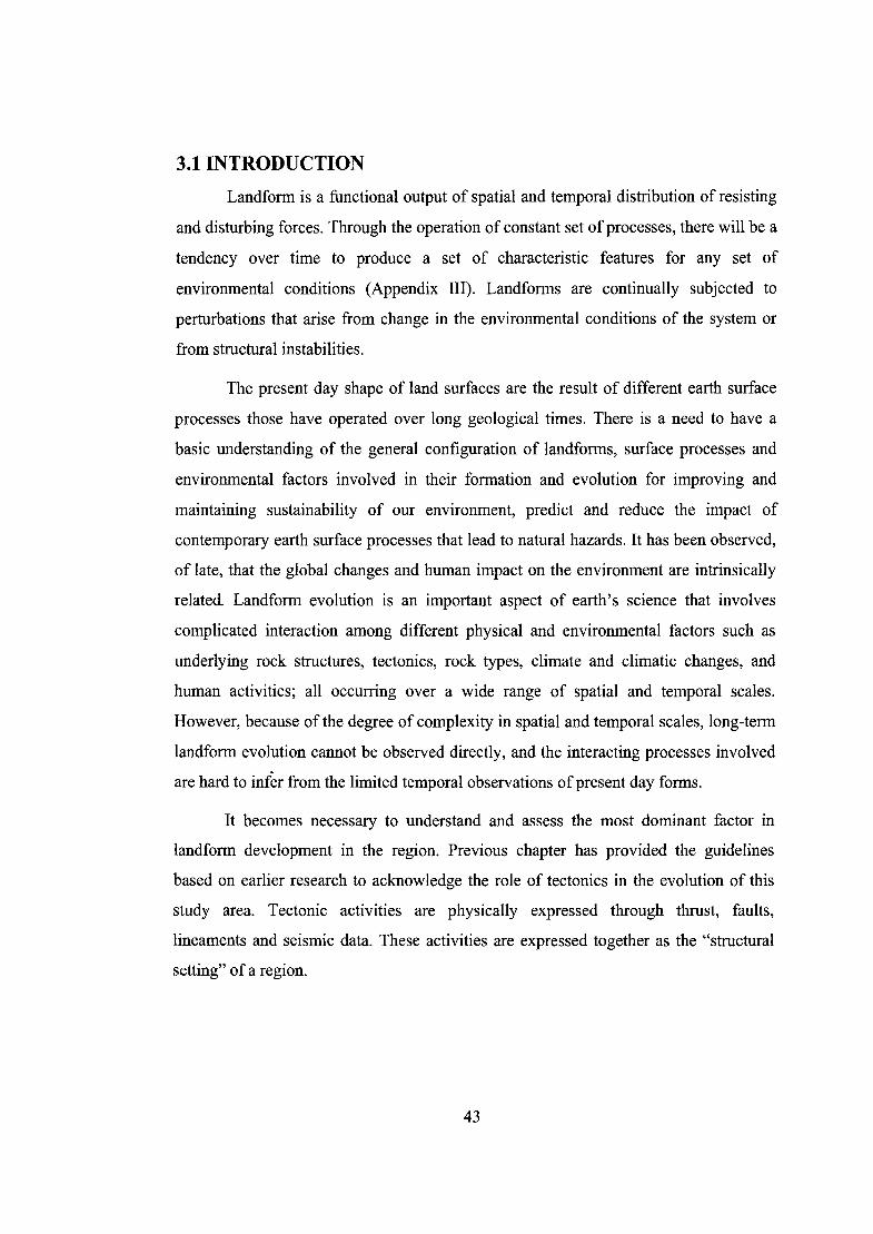
2. Non-directional filter (matrix):
0 -1 0
5 -1
0 -1 0
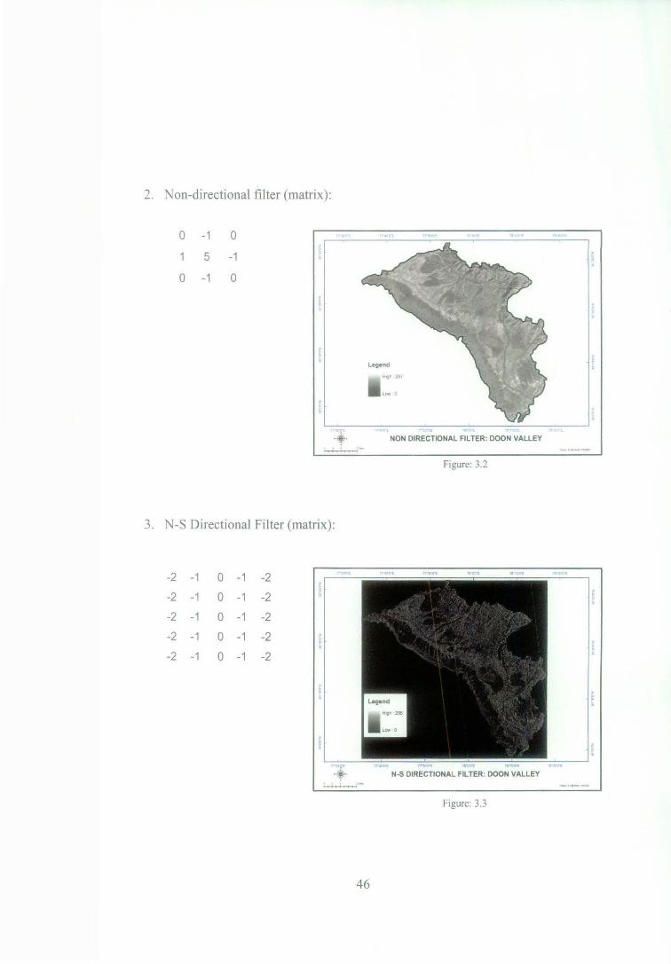
3. N-S Directional Filter (matrix):
-2 -1 0 -1 -2
-2 -1 0 -1 -2
-2 -1 0 -1 -2
-2 -1 0 -1 -2
-2 -1 0 -1 -2
NON DIRECTIONAL FILTER: DOON VALLEY
Figure: 3.2
N-S DIRECTIONAL FILTER: DOON VALLEY
Figure: 3.3
46

4. E-W Directional Filter (matrix):
2 2 2 2 2
1 1 1
0 0 0 0 0
-1 -1 -1 -1 -1
-2 -2 -2 -2 -2
E-W DIRECTIONAL FILTER: DOON VALLEY
Figure: 3.4
5. NE-SW Directional Filter (matrix):
-4 -3 -2 -1 0
-3 -2 -1 0
-2 -1 0 2
-1 0 2 3
0 2 3 4
NE.SW DIRECTIONAL FILTER: DOON VALLEY
Figure: 3.5
47

6. NW-SE Directional Filter (matrix):
0 2
-1 0
-2 -1 0
-3 -2 -1
-4 -3 -2
3 4
2 3
2
0
-1 0
·t- NW-SE DIRECTIONAL FILTER: DOON VALLEY
Figure: 3.6
Individual image was mapped with respect to the linear feature enhanced in
after applying all the image enhancement techniques (Figures 3.2, 3.3, 3.4, 3.5 & 3.6).
The identification of lineament was carried out on a 1:250,000 scale. Thereafter, traced
features were overlaid upon each other for extracting most commonly intersected
feature. Due care was taken to minimize the effect of various factors such as season,
vegetation, solar angle, spectral and spatial resolution in identification of lineament. In
addition, care was also taken to minimize the effect and eliminate man made features
with linear appearance such as road, rail and canal.
In the study area, 150 lineaments which are more than one kilometers of length
have been considered and mapped. The total length of all the lineaments put together is
457 kilometers (Table 3.1 ). These lineaments may represent sub-surface phenomenon.
The lineaments, furthermore, are analyzed in terms of trend and position compared to
the faults those have been previously mapped.
48

49

Trend of Lineaments : Doon Valley
90
180
Figure: 3.7
Majority of the lineaments have a NE-SW trend (Table 3.1 and Figures 3.7 &
3.8). The region north of Asan river appears to be tectonically more active as per the
density of lineament compared to other parts. Similar observations were earlier made by
Raiverman (1983) and Philip ( 1996), which they had inferred from the shift in river
50

courses (Figure 3.11 ). Furthermore, length of lineament does not correlate significantly
with the trend. With respect to the geological formation, concentration of lineaments
are generally more in the diverse areas (also see Figure 2.7). General trends show that
the upper Siwalik has NE-SW orientation with short length lineaments, the Chandpur
formation has NNE-SSW orientation; and the Krol formation has WNW - ESE
orientation. Rest of the regions have generally varied orientations. The regions with
higher density of lineaments have more complex geomorphic representation in this
study area.
z ..
77 JOYl"E
·•· . 77 40'0"E 77"501l"E 78"0'0"E 78"10'0"E
LINEAMENT MAP: DOON VALLEY
Figure: 3.8
3.2.2 EVIDENCES OF ACTIVE TECTONICS:
z
~ 0
The Doon valley comes under the tectonically active zone. Neotectonic zones
are identified through dynamic geomorphological features like tilting of piedmonts,
uplift and displacement of river terraces, offset river courses and linear features (Joshi
and Patel, 1997). There are many active faults in the study area such as the Mohand,
51

Santokhgarh fault and the MBT etc (Figure 3.9). Reactivated faults here have lead to
dislocation of many streams, alluvial fans and river terraces. The Doon valley, which
experienced severe tremors during the Kangra Earthquake in 1905 and Uttarkashi
Earthquake in 1991, provides platform to study crustal movements of recent origin in
this region (Philip, 1995).
sw NE
Moho-><l Dun Voll ey Sontokhgo rh MBT Mussoo~ i e fau ·t I
0 5km
Figure: 3.9 Cross Section of Major Active Faults (Modified after Raiverman eta/., 1983)
The Siwalik sediments exposed in the sub-Himalayas typically show coarser
grains upward in the cross section, with fan conglomerate (Doon gravels) covering the
top. This evidence is often interpreted as an evidence for progressive rise of the
Himalaya and the recent onset of tectonism along the MBT. The MBT cuts the post
Siwalik sand gravel and is still active (Mahindra et al., 1997). A tilted post Siwalik
boulder bed is present in the northwestern part of the Doon valley (Rao, 1977). The
Langha boulder bed rests unconformably on the upturned Siwalik sediments in Doon
valley. Two parallel faults, well within the piedmont fan deposit, have been identified
as Donga and Bhelonwala fault (Figure 3.1 0). The Donga Fault is also described as the
Santaurgarh Thrust which extends into the Debra Dun fan (Raiveman et al. , 1983).
Singh et al. , (2004) found the Bhelonwala fault lying to the north ofBhauwala Thrust.
52

a KROL THRUST r--JFAULT L=:::J 1NEOTECTONIC)
N
}
DEHRADUN
~LANGHA
~ BOULDER BED
Figure: 3.10 Donga and Bhelonwala fault (after Rao, 1977).
Philip ( 1996) also identified the shift in courses of river channels of Sitla and
Suarna Rao in the western Do on (Figure 3.11 ). Similar direction in shift shows the tilt
of the Donga fan in a particular direction and is the result of active tectonic in the
regwn.
lv-1 Pieornonl Fan
Figure: 3.11 Shifting of River Courses (after Philip, 1996)
53

The active character of the HFT is also observed near the Dhol Khand Fault (i.e.
near intersection of Bhimgoda thrust and HFT) in the Siwalik Hills where uplift in the
river bed has been reported by the local people (Mazari, 1996). The occurrence of
faults , thrust and trend of lineament clearly explains the intensity and direction of the
compressive forces being applied in the study area. The tectonic force causes the
formation of faults and thrusts once it reaches stress beyond holding capacity of the
region. The weak zones along the direction of force (the Ganga and Yamuna tear faults)
further ease the movement caused by compressive forces, thereby resulting smaller
expressions. Lineaments are developed as a result of uneven stress holding capacity of
the region reflected by directional trend in this study area.
Focus of the present study is to evaluate relative role of tectonics along with the
prevailing climate and past climatic regimes in the evolution of landforms of the Doon
valley.
3.3 LANDFORM EVOLUTION:
Spatial distribution of landforms IS represented by the distribution of
geomorphological features over space. Temporal characteristics are shown by the facies
associations and their inter-relationship. Facies is defined as a unit or group of units that
exhibit peculiar lithological, sedimentological or faunal characteristics, which enable
them to be distinguished from unit or groups of units adjacent to it. These units are
homogenous in terms of any particular characteristics. Facies analysis can vary from
simple to very complex methods that could be from visual observation to the
lithological, structural and chemical properties of the units. Whereas, stratigraphy refers
to vertical arrangement of different facies, usually referring to chronological order of
build up.
In geological context, the Doon valley landforms essentially comprise of two
components. These components are formations and faults. Formations reflect the
lithology and stratigraphy of the Doon valley. Faults have played an effective role in the
54

initiation of the fan formation, fan-head entrenchment and the segmentation of the fan
(Mukerji, 1988). These fans have developed on the underlying upper Siwalik formation.
Figure 3.12 shows the arrangement of different layers in the Doon area; starting from
Proterozoic basement, Sabathu formation (SB), Dharmshala formation (DH), lower
Siwalik (LS), middle Siwalik (MS) , and upper Siwalik (US) to Doon gravels on the top .
1V'chcrG ;'>icrihetr S:w:JI;k D::.s:ope Sfrearns
Sou!hc:T. S WOIJ' !
v I ~I
/ - I "'-- . "-..
Dun Sync/ire
---/ /
--- ---1 / /-
Figure: 3.12 Schematic diagram of structural layer arrangement (after Thakur, (1995)
The following criterion have been used for the identification and differentiation
to assess and build on the evolution of the Doon valley-
•
•
•
•
•
Identification of particular geomorphic regimes .
How these are related to particular climatic and a geological regime .
Key agent and processes associated with each geomorphic regime .
Role of tectonic movements in landscape development.
Landscape changes and processes involved in their evolution .
55

3.3.1 GEOMORPHOLOGICAL CHARACTERISTICS:
Geomorphology is the science concerned with the form of land surface and the
processes that create it (Summerfield, 1991 ). Processes that operate on the surface are
directly related to the environmental condition of that region of a given time. Nossin
( 1971 ) had prepared first detailed geomorphic map of the Doon valley by using aerial
photographs. He suggested that this synclinal valley is of post Upper Siwalik in age,
and that the uplift of 950ft to 1250 ft occurred in the valley since the Upper Siwalik
times. Nakata ( 1972) had observed some tectonic movements and concluded that the
Doon valley evolved as a result of intricate superimposition of alternate depositional
phases, caused mainly by climatic changes and crustal movements over the past
hundred thousand years. Nossin ( 1971 ) had divided the Doon into three main
geomorphic divisions:
• The Siwalik range
• The Doon valley
• Other various fluvial features
7130)"E
Legend
L]sn !;::;::Iss ~Sol
DDfl c.::::Jotd CJotp
Dfh
~Dt
O Ft ~Lho
-Lh
- Rbf
'1 J.I''O"E 77~50'0"E
78"0'0"E 78"10'0"E 1& 20'0"E
Modtfied lllterNosm. 1971
78"0'0"E 78" 10'0"E 78"20'0"E
GEOMORPHOLOGICAL MAP: DOON VALLEY
Figure: 3.13
56

These divisions have been further subdivided with some modifications as given
below. These modifications are based on image analysis of ASTER image, keeping in
consideration the slope, aspect, elevation and field details (Figure 3.13). The
categorization scheme proposed here is similar to Nossin (1971). Subdivisions proposed
for the study area is as following:
Siwalik range:
Sn - northern Siwalik
Ss- southern Siwalik
Sol - outlier of Siwalik
Doon valley:
Dfl - lower realm of principal fans
Dfd - dissected parts of principal fans
Dfp - principal Doon fans
Dfh - high level fan terraces
Dt - fan terraces below principal fans
Fluvial features:
Ft- fluvial terraces
Others:
Lho - outlier of lesser Himalaya
Lh - lesser Himalaya
Rbf- river bed features
57
A$ban R
Dfp -----Ss--- : i ~..--~.---..:"'""""'-, ............. ~--+--.:~---l : : i : : : : I 1 1 1 1 I 1 I 1 1 I
----Ss~ &habet faull Uotichur An Song A I . .
I ' : ·-v---~----~-~~ I I I I I I I I I
i
I I I
S lw alI k R.a n Q e
' ' ~ : ' ' ' '
Dfl
4000
3000
Northwest Section _,
fool -, ....
hiiii0,17.J ... J,210
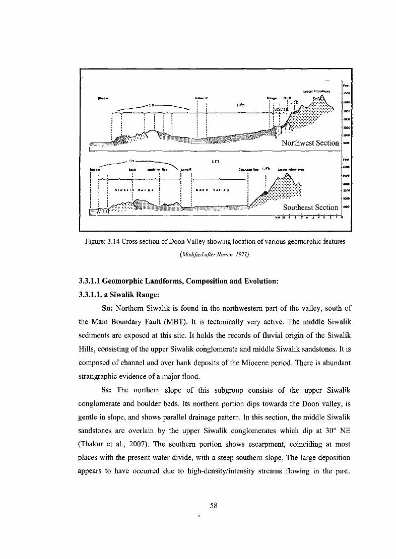
Figure: 3.14 Cross section ofDoon Valley showing location of various geomorphic features
(Modified after Nossin, 1971).
3.3.1.1 Geomorphic Landforms, Composition and Evolution:
3.3.1.1. a Siwalik Range:
Sn: Northern Siwalik is found in the northwestern part of the valley, south of
the Main Boundary Fault (MBT). It is tectonically very active. The middle Siwalik
sediments are exposed at this site. It holds the records of fluvial origin of the Siwalik
Hills, consisting of the upper Siwalik conglomerate and middle Siwalik sandstones. It is
composed of channel and over bank deposits of the Miocene period. There is abundant
stratigraphic evidence of a major flood.
Ss: The northern slope of this subgroup consists of the upper Siwalik
conglomerate and boulder beds. Its northern portion dips towards the Doon valley, is
gentle in slope, and shows parallel drainage pattern. In this section, the middle Siwalik
sandstones are overlain by the upper Siwalik conglomerates which dip at 30° NE
(Thakur et al., 2007). The southern portion shows escarpment, coinciding at most
places with the present water divide, with a steep southern slope. The large deposition
appears to have occurred due to high-density/intensity streams flowing in the past.
58

There is considerable evidence to support a major change in the flow regime. They
evolved in the Pliocene to Pleistocene periods.
Sol: The Nagsidh hill is in the east central part of the valley. It is a detachment
of the Siwalik hills with an average elevation of 700 meters. River Suswa might have
been the cause for such a detachment, with continued erosion for thousands of years.
3.3.1.1.b Doon Valley:
Dfl: It is in the lower portion of the principal fans i.e. of Donga, Dehra Dun and
Bhogpur fans, and little elevated from the main river channel. The upper part is steeper
compared to the gradient in the lower section. It is composed of small sized boulders,
cobbles and pebbles as compared to the principal Doon fans. It indicates a low energy
fluvial regime.
Dfd: It is detached part of the principal fan formed by numerous streams and re
exposed Siwalik. This evolution is the result of head-ward erosion by streams along
with the ongoing tectonic activities in the region.
Dfp: Very coarse boulder beds with sandy and silty matrix characterize these
fans. These are the large fans developed along the lesser Himalayan front, evolved due
to the streams debouching on to the lesser gradients of the foreland plain. The evidence
indicates to a relatively high river discharge during evolution. It is separated in the
north by the Santaurgarh fault, with numerous small streams emerging at the toe of the
fan. Dehra Dun city is situated on this landform sub-division.
Dtb: These are high-level fan terraces lying above in the lesser Himalaya, and
above the Siwalik hills (Plates 2 & 3), indicating a clear break in gradient. These are
relatively flat surfaces but steeper at the fan-head. These terraces are the result of
movement along the MBT and Santaurgarh fault, providing excellent example of
tectonic uplift and movement along the boundaries. These terraces are found near
Rajpur.
Dt: It is a terrace in the fan surface along the river. It is formed by the seasonal
change in the discharge of the river.
The compositions of the fan deposits mainly consists of coarse gravel, pebble
and cobble, and are well rounded except in the upper reaches. The thickness of the
59

gravels, as indicated by tube-well depths, varies from~ 100 m in proximal part to ~ 300
m in the distal part of the fan (Thakur et al., 2007). At few places, large boulders and
blocks are found. At lower levels of fans, finer components are significant. These are
mainly composed of quartzite or quartzitic-sandstone. Wherever, the Siwaliks are
exposed pebbles mixed with the Doon gravels. Such large fans point to the Pleistocene
inter -glaciations.
3.3.1.1.c Fluvial Features:
The fluvial terraces are found along most of the presently flowing rivers.
Pebbles dominate in the deposits of these terraces which show sandy layers within the
section (lens). The lenses probably indicate mild phases of deposition, or the variation
in annual climatic regime towards low intensity. These appear to be the common
depositional features of these rivers.
3.3.1.1.d Other Features:
The outlier of the lesser Himalaya is found in the north central part of the valley,
between the lesser Himalaya and Song River, commonly known as Kalanga hill. Song
river may have detached these hills from the lesser Himalayas. The lesser Himalayas,
being completely mountainous lies in the NE of the Main Boundary Thrust. The river
bed features are mainly composed of sand, within 100 m along present river channel.
3.3.2 LITHOSTRATIGRAPHICAL CHARACTERISTICS:
The sedimentation history of the Mohand area, interpreted from ONGC
exploratory-well seismic profile shows two overlapping alluvial fan systems. In the first
alluvial fan system, sheet floods developed the lower sandy alluvial fan in braided trunk
river system with proximal river flood plain deposits, the deposition which occurred in
radial alluvial fan setting with lower rate of subsidence and supply of detritus from the
inner lesser Himalaya. In the second alluvial fan system, MBT became active and the
source lithology changed from inner to the outer lesser Himalayan (i.e. Krol belt) and
the continued advancement of the thrust sheet along MBT, increase in gravel influx
60

from the north causing transformation of braided river to alluvial fan system (Kumar, et
al., 1994 and Thakur et al., 2007).
The stratigraphic records of the Doon valley can be summerised in Table 3.2
below:
Table: 3.2 Lithostratigraphy in the Doon Valley.
AGE FORMATION LITHOLOGY
Recent River alluvium Sand, silt and clay
Late Pleistocene to early Holocene Doon fan gravels Pebbles, sand and clay
Late Pleistocene Old Doon gravels Boulders, pebbles, sand and clay
Unconformity
Pliocene to Pleistocene Upper Siwalik Conglomerate and clay bed
Miocene to Pliocene Middle Siwalik Micaceous with intercalation of clay
Miocene Lower Siwalik Sand stone and interbedded clay
Unconformity
Paleocene to middle Eocene Sabathu series Shale, sandstone and limestone
Unconformity
Permian to Triassic Krol Limestone, slate and shales
Carboniferous Infra krol Slates boulders beds and quartzite
Permian Nagthats Quartzite with minor shales
Lower Paleozoic to Pre Cambrian Chandpurs Slates, phyllites thin quartzites
Pre Cambrian Mandhali Slate, limestone
Source: Arya (2004) Appendix Ill, IV, V
61

'-0
- ~\...l d~tone Ll l\ll ud~tone- /Po ~a5ool
U ("'"one ret ionor )I Ioyer :$
Figure: 3.15 Modified after Kumar and Ghosh (1994) .
Table 3.1 and Figure 3.15 show that the lower Siwaliks are made up of
sandstones and inter-bedded mudstones, with thickness of about 2000 meters and age of
about 14 Ma to 18 Ma. The middle Siwalik shows multi-storied sandstone with pebble
and mudstone siltstone and planner stratification of thickness is about 1800 meters,
aged about 1 0 Ma to 6. 7 Ma. The upper Siwalik having thickly bedded massive
conglomerate in sandy matrix and inter-bedded sandstone with thickness of about 2000
meters have ages ranging from 0.5 Ma to 5 Ma (Appendix III and IV and Plate 1 ),
above which lies the Doon gravel. Old Doon gravels and Doon fan gravels constitutes
thickly bedded massive conglomerates embedded in sandy-silty matrix with thickness
of - 600 meters and age range from recent to 0.5 Ma (Thakur, 1992).
3.4 ROLE OF CLIMATE AND TECTONICS IN THE EVOLUTION:
Tectonics has played an important role in the structuring of the Doon valley.
Geomorphology and lithostratigraphy records show well developed layered formations
of different geological times in the study area. All these layered formations are the
result of peculiar behavior of sub-surface movements and climatic variability over a
62

large temporal scale. Apart from these, one of the most striking features in the Doon
valley is the spread of fan at the toe region. A fan (alluvial) normally is a sedimentary
deposit located at a topographic break, and usually has a shape of fan. Such large fans
are usually indicative of some extreme situations coupled together. Mukheiji (1988)
concluded that the fan deposition is related to continuing semi-arid climatic conditions,
which is more a variant of Koppen's Cwg, characterized by high rainfall, thunderstorms
and thundershowers, and floods .
The evolution of Doon valley can be summarized into different stages, shown in
the schematic diagrams below (direction and boundary are not to true scale).
3.4.1 STAGE 1:
Evolution m this stage
began around 14 Ma-18 Ma BP in
the Miocene period when there
were gradually flowing streams.
The energy of the streams appears
to have been low; as reflected by
the absence of any coarse debris.
There is no evidence to suggest any
punctuation in the environmental
process during this period. The
·•·
0 5 Kllometera E3
Figure: 3.16
rivers appear to have carried sediments from the inner lesser Himalaya. Lithology that
formed at this stage consists mainly of sandstone and inter-bedded clay. There was no
structural barrier in the SW region at this stage (Figure 3.16). All the material brought
down by the rivers spread in the foreland region of the mountains. The Lower Siwalik
formations are probably of this stage.
63

3.4.2 STAGE II:
This stage formed between
6 to 10 Ma BP, and belongs to the
late Miocene period. This period
witnessed the initiation of the
MBT, creating a break in slope.
The initiation of MBT, and change
in the base level might have led to
an mcrease m the canymg
capacity of the rivers. As a result, 0 5 Kilo,.tors E3
dissection might have increased Figure: 3.17
many-folds along the MBT. It would have further led to the drastic change in the bed
load, and change in material (lithological) from the inner lesser Himalayas to outer the
lesser Himalaya (Kumar, 1994). Lithology of this stage mainly consists of clay bed and
conglomerates. Continued thrusting along the MBT is reflected by the gravel size and
depositional setup. The period of middle and upper Siwalik sedimentation continued
from late Miocene to early Pleistocene. The depositional environment constitutes
mainly sheet flood braided streams on distal sandy alluvial fans in the middle Siwalik
sedimentation; and mainly gravel load braided streams and sheet flood on distal alluvial
fan in the upper Siwalik sediments. Thrusting along the MBT and increase in the source
area towards southern side led to the transformation of a braided river system to that of
a gravelly alluvial fan. These activities happened up to 0.5 Ma until the initiation of
HFT. The force was in the specified direction and can be assumed by looking at the
arrangement of the river Ganges and Yamuna tear faults, and exposed areas in the
northern Siwalik in NW part of the valley (Figure 3.17; Arya, 2004).
3.4.3 STAGE III:
This stage started around 0.5 Ma after the initiation of HFT. This stage is
directly linked with the formation of the main Doon valley. Filling started just after
creation of syncline (Figure 3.18), earlier debris brought by rivers used to spread in the
foreland of the lesser Himalaya. The development in the HFT initiated the formation of
64

the Doon valley and coeval deposition of Doon gravels. The upper age limit of the
upper Siwalik is estimated at 0.5 Ma, which is also the lower age limit of Doon gravels
(Nossin, 1971 ). The fan debris are
brought from north due to tectonic
activity along the MBT. The Doon fan
gravels consist of boulder
conglomerates that consist of pebbles,
cobbles and boulders of sandstone,
limestone, quartzite and schist. The
presence of lime shows that they are
derived from the pre-Siwalik formation
·+· '
0 5 Kilometers E3
Figure: 3.18
(Plate 4) . Very little has been picked from upper Siwalik boutaer conglomerate.
Mukherji (1988) also suggested that the fan deposition is related to continued semi-arid
climatic conditions. Fan developed from the upper Pleistocene to early Holocene, a
period of glaciations and inter-glaciations. Discharge of the rivers also increased due to
Pleistocene inter-glacial episode. The evolution of the Santaurgarh fault further added
to the influx of debris from the upper reaches.
Topographic expressions and landforms present in the Doon valley point to the
sequential evolution. The tectonic movements and the interglacial phase initiated the
fan formation. Koppen's Cwg climate monsoon rainfall had got established by the time
fans stared to form (Mukerji, 1988). The establishment of Cwg climate is coterminous
with the uplift of Himalaya. There was a continued procession in the climate in an
episodic manner from arid to semi-arid to humid, perfectly favorable for fan formation.
In summary, it can be said that the evolution oflarge fans in the Doon is the outcome of
multi-cyclic rhythms of tectonics and climate variations (glacial and inter-glacial) over
a long geological period.
65