Embed Size (px)
Citation preview
115
IntroductionWildlife habitat is a concept that describes attributes inthe environment that serve as life requisites for wildlifeallowing them to survive and reproduce. An overtassumption is that wildlife use habitats that are arrangedor comprised of vital components; these arrangementsresult in healthy and viable wildlife populations. However,the wildlife habitat concept does not address demographic(survival and reproduction of individuals), environmental(food supply, predators, weather), natural catastrophe(flood, drought, fire), or genetic (genetic drift orinbreeding) uncertainties. These uncertainties, thoughimportant, are difficult to determine, predict, and manage.Nonetheless, we have studied and assessed wildlife lifehistory and how species use their habitat(s) for quite sometime. Thus, the wildlife habitat concept does addressfeatures in the environment that we can manipulate toenhance or discourage wildlife use of an area.
The principal purpose of this chapter is to report whatwe know or surmise about wildlife and its use of thelandscape into features that land managers canunderstand, recognize, and strive to achieve. Describingand defining these features allows us to begin to establisha common understanding for management so that we canaffect and influence the landscape to meet wildlife needs.What follows is an expansion of our wildlife habitats; twomajor features that also service wildlife species needs arestructural conditions and specific habitat elements of asite. These two features should be viewed in a hierarchicalmanner, with structural conditions occurring on tracts ofland such as at a forest stand or watershed level, wherebyhabitat elements are described at a site-specific or locallevel, like within a forest stand. Knowing something aboutstructural conditions of an area along with the habitatelements occurring at a site will allow us to better predictwhat kinds of wildlife may use the site, as well as predict,if enhancements or modifications were made what wildlifemight continue to use the site or area.
The collective set of environmental conditions providedby wildlife habitats, structural conditions, and habitatelements constitutes a species� overall habitat. Hence, froman ecological perspective, we are striving to determine thecurrent and potential ecological conditions of a landscape
3Structural Conditions and Habitat
Elements of Oregon and Washington
Thomas A. O�Neil, Kelly A. Bettinger, Madeleine VanderHeyden, Bruce G. Marcot, Charley Barrett, T. Kim Mellen,
W. Matthew Vanderhaegen, David H. Johnson,Patrick J. Doran, Laurie Wunder, & Kathryn M. Boula
or site. We achieve this knowledge by interpolatingecological condition from assessing wildlife habitatshierarchically, that is, from knowing something about thewildlife habitats, structural conditions, and habitatelements from area or site. Thus, current and desiredecological conditions can be assessed for wildlife andwritten:
Wildlife Habitats = wildlife cover type(s) + structuralcondition(s) + habitat element(s)
Structural ConditionsStructure is what a natural resource manager canmanipulate to achieve various objectives. After all,manipulating the structural features of a forest stand iswhat silviculture is all about.10 Structural conditions areoften thought to follow the plant succession series. Thatis, if a stand, say in a forest, is left alone and given enoughtime it will achieve a climax or old-growth state. So thecontinuum starts with the earliest stages, and given a forestexample, this would be at grass/forb, and thenprogressing through shrub/seedling; sapling/pole; small,medium, and large trees; and eventually achieving gianttrees. Catastrophic events along with some managementprescriptions can reset the succession stages (fire burninga tract of land mimics in many ways the effect of a clearcut).So several key structural elements for forest andshrubland/grasslands habitats are a wide range in treeand shrub sizes, a wide range in tree diameters and treeand shrub heights, and varying amounts of tree and shrubcanopies. Multiple canopy layers are also considered tobe significant and this includes the continuous distributionof foliar surface from the top of the crown to the ground.Such canopy distributions are thought to create greaterquantities and greater diversity of animal habitats.10, 13 Thatis, canopies are important not only for their physicalcharacteristics, such as thermal qualities that influencestream temperatures and ground conditions (i.e. shade,shelter from precipitation) but also for their abiotic abilitiessuch as fixating CO2 or nitrogen from the atmosphere.2, 11,
17 Finally, plant and tree understories may or may not bepresent depending on the structural condition of the stand;
116 Wildlife�Habitat Relationships in Oregon and Washington
however, their presence can influence the kind andnumber of species that use the stand.
Defining Structural ConditionsKnowing the wildlife-habitat type(s) of an area will allowa person to predict a list of species that may be found atthat site. To refine the prediction, however, requires furtherinformation, like knowing a species range extent andcondition of the habitat in the area of concern. The termcondition implies, knowing the types and amounts ofdifferent structural stages and habitat elements. Thecondition of the habitat can predispose a species to use anarea, and thus can serve as a driver for its occurrence.
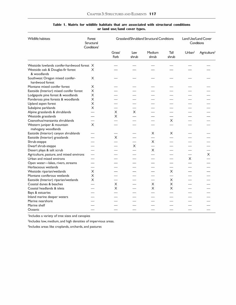
Definitions of structural conditions were determinedby the Species Habitat Team that was formed frommultiple organizations to help clarify terms, represent fieldecologist and biologist needs, and to help ensure a usableend-product. The definitions are divided into four majorcategories: Forest, Shrubland/Grassland, Agriculture, andUrban. The definitions for the first two categories are basedon describing the characteristics of trees, shrubs, andgrasses. The last two categories are based on describingland use/land cover types. This was done because of thedifficulty in describing these categories from a plantcommunity perspective and because there is very littleliterature available that would allow a more detailedbreakdown. Table 1 was created to depict those wildlifehabitats that are associated with each structural conditionor land use/land cover type. A computer simulation thatrepresents each Forest and Shrubland/Grasslandstructural condition can be found by reviewing the colorphotographs that accompany this chapter. The followingare the definitions for structural conditions:
Forest Structural ConditionsThe forest structural conditions are based on the followingattributes: (1) tree size diameter at breast height (dbh); (2)percent canopy cover (or percent grass/forb cover); and,(3) number of canopy layers. These attributes have thefollowing values:
Tree size (dbh)shrub/seedling <1 inch <2.5 cmsapling/pole 1-9 inches 2.5-24 cmsmall tree 10-14 inches 25-37 cmmedium tree 15-19 inches 38-49 cmlarge tree 20-29 inches 50-75 cmgiant tree >30 inches >76 cm
Percent canopy coveropen 10-39%moderate 40-69%closed 70-100%
Number of canopy layerssingle story 1 stratummulti-story >2 strata
The above attributes have been combined into thefollowing structural conditions:
1. Grass/Forb�OpenGrass/Forb dominated with <70% coverage by grassesand forbs. Shrubs and small seedlings may be present,but do not dominate stand, (seedlings <10% canopy cover),and there may be remnant trees (trees remaining from theprevious stand) that provide <10% canopy cover (Figure1).
2. Grass/Forb�ClosedGrass/forb dominated with >70% coverage by grasses andforbs. Shrubs and small seedlings may be present, but donot dominate stand, (seedlings <10% canopy cover), andthere may be remnant trees (trees remaining from theprevious stand) that provide <10% canopy cover (Figure2).
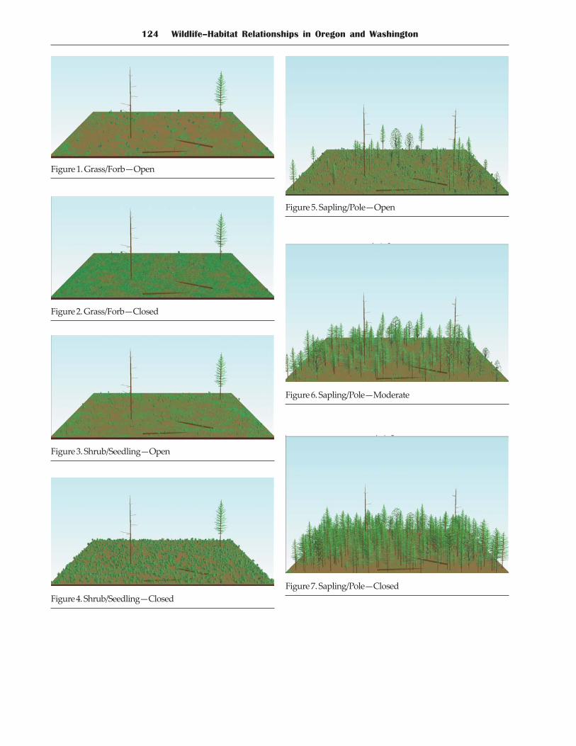
3. Shrub/Seedling�OpenSeedlings are large enough to add structure to the standbut are small enough that the structure is similar to shrubsand may have remnant trees (trees remaining from theprevious stand) that provide <10% canopy cover. There is<70% cover of shrubs or seedlings. Tree size is <1 inchdbh, and there is 1 canopy stratum (Figure 3).
4. Shrub/Seedling�ClosedSeedlings are large enough to add structure to the standbut are small enough that the structure is similar to shrubs.Remnant trees (trees remaining from the previous stand)may provide <10% canopy cover. There is >70% cover ofshrubs or seedlings. Tree size is <1 inch dbh, and there is1 canopy stratum (Figure 4).
5. Sapling/Pole�OpenThe canopy is open enough that understory vegetationmay be abundant. Remnant trees (trees remaining fromthe previous stand) may provide <10% canopy cover.There is 10-39% cover of sapling and pole-sized trees. Treesize is 1-9 inches dbh, and there is 1 canopy stratum (Figure5).
6. Sapling/Pole�ModerateUnderstory development is hampered by available lightand moisture. Remnant trees (trees remaining from theprevious stand) may provide <10% canopy cover. Thereis 40-69% cover of sapling and pole-sized trees. Tree sizeis 1-9 inches dbh, and there is 1 canopy stratum (Figure6).
7. Sapling/Pole�ClosedThe understory is depauperate or absent. Remnant trees(trees remaining from the previous stand) may provide<10% canopy cover. There is >70% cover of sapling andpole-sized trees. Tree size is 1- 9 inches dbh and there is1canopy stratum (Figure 7).
8. Small Tree�Single Story�OpenA grass/forb or shrub understory may be present.Remnant trees (trees remaining from the previous stand)may provide <10% canopy cover. There is 10-39% coverof small trees, with <10% cover of other tree sizes. Treesize is 10-14 inches dbh, and there is 1 canopy stratum(Figure 8).
CHAPTER 3: STRUCTURES AND ELEMENTS 117
Table 1. Matrix for wildlife habitats that are associated with structural conditionsor land use/land cover types.
Wildlife habitats Forest Grassland/Shrubland Structural Conditions Land Use/Land CoverStructural ConditionsConditions1
Grass/ Low Medium Tall Urban2 Agriculture3
Forb shrub shrub shrub
Westside lowlands conifer-hardwood forest X � � � � � �Westside oak & Douglas-fir forest X � � � � � � & woodlandsSouthwest Oregon mixed conifer- X � � � � � � hardwood forestMontane mixed conifer forest X � � � � � �Eastside (Interior) mixed conifer forest X � � � � � �Lodgepole pine forest & woodlands X � � � � � �Ponderosa pine forests & woodlands X � � � � � �Upland aspen forest X � � � � � �Subalpine parklands X � � � � � �Alpine grasslands & shrublands � X X � � � �Westside grasslands � X � � � � �Ceanothus/manzanita shrublands � � � � X � �Western juniper & mountain X � � � � � � mahogany woodlandsEastside (Interior) canyon shrublands � � � X X � �Eastside (Interior) grasslands � X � � � � �Shrub-steppe � � � X � � �Dwarf shrub-steppe � � X � � � �Desert playa & salt scrub � � � X � � �Agriculture, pasture, and mixed environs � � � � � � XUrban and mixed environs � � � � � X �Open water�lakes, rivers, streams � � � � � � �Herbaceous wetlands � � � � � � �Westside riparian/wetlands X � � � X � �Montane coniferous wetlands X � � � � � �Eastside (Interior) riparian/wetlands X � � � X � �Coastal dunes & beaches � X � X X � �Coastal headlands & islets � X � X X � �Bays & estuaries � � � � � � �Inland marine deeper waters � � � � � � �Marine nearshore � � � � � � �Marine shelf � � � � � � �Oceanic � � � � � � �1Includes a variety of tree sizes and canopies2Includes low, medium, and high densities of impervious areas.3Includes areas like croplands, orchards, and pastures
118 Wildlife�Habitat Relationships in Oregon and Washington
9. Small Tree�Single Story�ModerateSome grass/forb or shrub understory may be present.Remnant trees (green trees remaining from the previousstand) may provide <10% canopy cover. There is 40-69%cover of small trees with <10% cover of other sized trees.Tree size is 10-14 inches dbh, and there is 1 canopy stratum(Figure 9).
10. Small Tree�Single Story�ClosedGrass/Forb or shrub understory minor or absent.Remnant trees (trees remaining from the previous stand)may provide <10% canopy cover. There is >70% cover ofsmall trees, with <10% cover of other-sized trees. Tree sizeis 10-14 inches dbh, and there is 1 canopy stratum (Figure10).
11. Medium Tree�Single Story�OpenA grass/forb or shrub understory may be present.Remnant trees (trees remaining from the previous stand)may provide <10% canopy cover. There is 10-39% coverof medium trees, with <10% cover of other-sized trees.Tree size is 15-19 inches dbh, and there is 1 canopy stratum(Figure 11).
12. Medium Tree�Single Story�ModerateGrass/Forb or shrub understory may be present. Remnanttrees (trees remaining from the previous stand) mayprovide <10% canopy cover. There is 40-69% cover ofmedium trees with <10% cover of other-sized trees. Treesize is 15-19 inches dbh, and there is 1 canopy stratum(Figure 12).
13. Medium Tree�Single Story�ClosedA grass/forb or shrub understory may be present.Remnant trees (trees remaining from the previous stand)may provide <10% canopy cover. There is >70% cover ofmedium trees with <10% cover of other-sized trees. Treesize is 15-19 inches dbh, and there is 1 canopy stratum(Figure 13).
14. Large Tree�Single Story�OpenGrasses, shrubs, and/or seedlings may occur in theunderstory. There is 10-39% cover of large and/or giantsize trees with <10% cover of other-sized trees. Tree sizeis 20-29 inches dbh, and there is 1 canopy stratum (Figure14).
15. Large Tree�Single Story�ModerateSome grass/forb or shrub understory may be present.There is 40-69% cover of large and/or giant trees with<10% cover of other-sized trees. Tree size is 20-29 inchesdbh, and there is 1 canopy stratum (Figure 15).
16. Large Tree�Single Story�ClosedGrasses, shrubs, and/or seedlings may occur in theunderstory. There is >70% cover of large and/or giant treeswith <10% cover of other-sized trees. Tree size is 20-29inches dbh, and there is 1 canopy stratum (Figure 16).
17. Small Tree�Multi-story�OpenThese stands have an overstory of small trees with adistinct subcanopy of saplings and/or poles. Scatteredlarger trees may be present but make up <10% canopycover. Grass/forb or shrub understory may be present.There is 10-39% total canopy cover dominated by smalltrees, >10% canopy cover of >1 other smaller tree sizes.Tree size is 10-14 inches dbh, and there are >2 canopy strata(Figure 17).
18. Small Tree�Multi-story�ModerateThese stands have an overstory of small trees with adistinct subcanopy of saplings and/or poles. Scatteredlarger trees may be present but make up <10% canopycover. Grass/forb or shrub understory may be present,but is probably limited. There is 40-69% total canopy coverdominated by small trees, >10% canopy cover of >1 ormore other smaller tree sizes. Tree size is 10-14 inches dbh,and there are >2 canopy strata (Figure 18).
19. Small Tree�Multi-story�ClosedThese stands have an overstory of small trees with adistinct subcanopy of saplings and/or poles. Scatteredlarger trees may be present but make up <10% canopycover. Grass/forb or shrub understory extremely limitedor absent. There is >70% total canopy cover dominatedby small trees, >10% canopy cover of >1 other smaller treesizes. Tree size is 10-14 inches dbh, and there are >2 canopystrata (Figure 19).
20. Medium Tree�Multi-story�OpenThese stands have an overstory of medium trees with adistinct subcanopy of smaller trees. Scattered larger treesmay be present but make up <10% canopy cover. Grass/forb or shrub understory may be present, but is probablylimited. There is 10-39% total canopy cover dominated bymedium trees, >10% or more canopy cover of >1 othersmaller tree sizes. Tree size is 15-19 inches dbh, and thereare >2 canopy strata (Figure 20).
21. Medium Tree�Multi-story�ModerateThese stands have an overstory of medium trees with adistinct subcanopy of smaller trees. Scattered larger treesmay be present but make up <10% canopy cover. Grass/forb or shrub understory may be present, but is probablylimited. There is 40-69% total canopy cover dominated bymedium trees, >10% or more canopy cover of 1 or moresmaller tree sizes. Tree size is 15-19 inches dbh, and thereare >2 canopy strata (Figure 21).
22. Medium Tree�Multi-story�ClosedThese stands have an overstory of medium trees with adistinct subcanopy of smaller trees. Scattered larger treesmay be present but make up <10% canopy cover. Grass/forb understory may be present, but is probably limited.There is >70% total canopy cover dominated by mediumtrees, >10% or more canopy cover of >1 smaller tree sizes.Tree size is 15-19 inches dbh, and there are >2 canopy strata(Figure 22).
CHAPTER 3: STRUCTURES AND ELEMENTS 119
23. Large Tree�Multi-story�OpenThese stands have an overstory of large or giant-sized treeswith one or more distinct canopy layers of smaller trees.Stands with >40% cover of giant trees are classified in theGiant, multi-storied stage. In westside forests, standsdominated by large trees usually have giant trees scatteredin the stand, with fewer in eastside forests. A grass/forbor shrub understory is often present, especially in canopygaps. There is 10-39 % total canopy cover, with >10% ormore canopy cover from large and/or giant trees andanother >10% canopy cover from >1 or more smaller treesize classes. Tree size is 20-29 inches dbh, and there are >2canopy strata (Figure 23)
24. Large Tree�Multi-story�ModerateThese stands have an overstory of large or giant-sized treeswith >1 distinct canopy layers of smaller trees. Stands with>40% cover of giant trees are classified in the giant,multi-storied stage. In westside forests, stands dominatedby large trees usually have giant trees scattered in thestand, with fewer in eastside forests. Grass/Forb or shrubunderstory is often present, especially in canopy gaps.There is 40-69% total canopy cover, >10% canopy coverfrom large trees with another >10% canopy cover from >1smaller tree size classes. Tree size is 20-29 inches dbh, andthere are >2 canopy strata (Figure 24).
25. Large Tree�Multi-story�ClosedThese stands have an overstory of large or giant-sized treeswith >1 distinct canopy layers of smaller trees. Stands with> 40% cover of giant trees are classified in the giant,multi-storied stage. In westside forests, stands dominatedby large trees usually have giant trees scattered in thestand, with fewer in eastside forests. A grass/forb or shrubunderstory is often present, especially in canopy gaps.There is >70% total canopy cover, >10% or more canopycover from large trees with another >10% canopy coverfrom >1 smaller tree size classes. Tree size is 20- 29 inchesdbh, and there are >2 canopy strata (Figure 25).
26. Giant Tree�Multi-storyThese stands have an overstory of giant-sized trees with>1 distinct canopy layers of smaller trees. Stands with<40% canopy cover are classified in the large treemulti-story open stage. There is >40% canopy cover. Treesize is >30 inches dbh, and there are >2 canopy strata(Figure 26a and b).
Shrubland and Grassland StructuralConditions
The shrubland and grassland structural conditions arebased on the following attributes: (1) shrub height, (2)percent shrub cover (or percent grass/forb cover), and (3)shrub age class. These attributes have the following values:
Shrub heightlow <1.6 ft <0.5 mmedium 1.6-6.5 ft 0.5-2.0 mtall >6.5 ft-16.5 ft >2.0 m-5.0 m
Percent shrub coveropen 10-69% shrub coverclosed 70-100% shrub cover
Shrub age classseedling/young negligible crown decadencemature < 25% crown decadenceold 26-100% crown decadence
The above attributes have been combined into thefollowing structural conditions:
1. Grass/Forb�OpenGrasslands that have <10% shrub cover and <10% treecanopy cover. Grasses and forbs cover are <70% of theground, and bare ground is evident (Figure 27).
2. Grass/Forb�ClosedGrasslands that have <10% shrub cover and <10% treecanopy cover. Grasses and forbs cover >70% of the ground(Figure 28).
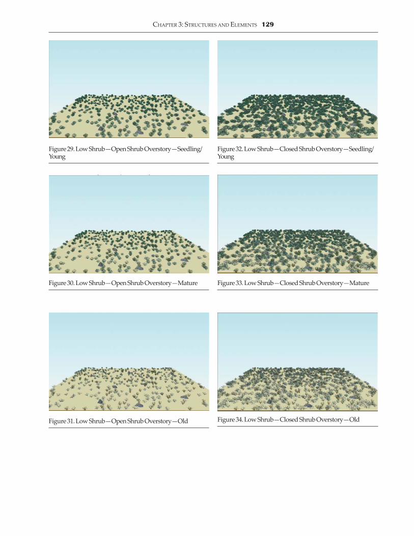
3. Low Shrub�Open Shrub Overstory�Seedling/YoungShrublands with shrubs <1.6 ft tall, shrub canopy cover10-69% and may have <10% tree canopy cover. Areas with<10% shrub cover are categorized as Grass/Forb. Theseare post-disturbance regenerating shrublands dominatedby seedlings or young shrubs. Mature, legacy shrubs maypersist from before the disturbance, but occur as scatteredsingles or widely scattered clumps. Crown decadence isnegligible (Figure 29).
4. Low Shrub�Open Shrub Overstory�MatureShrublands with shrubs <1.6 ft tall, shrub canopy cover10-69% and may have <10% tree canopy cover. Areas with<10% shrub cover are categorized as Grass/Forb. Crowndecadence is <25% (Figure 30).
5. Low Shrub�Open Shrub Overstory�OldShrublands with shrubs <1.6 ft tall, shrub canopy cover10-69% and may have <10% tree canopy cover. Areas with<10% shrub cover are categorized as Grass/Forb. Crowndecadence is >25% (Figure 31).
6. Low Shrub�Closed Shrub Overstory�Seedling/YoungShrublands with shrubs <1.6 ft tall, shrub canopy cover>70%, and may have <10% tree canopy cover. These arepost-disturbance regenerating shrublands dominated byseedlings or young shrubs. Mature, legacy shrubs maypersist from before the disturbance, but occur as scatteredsingles or widely scattered clumps. Crown decadence isnegligible (Figure 32).
7. Low Shrub�Closed Shrub Overstory�MatureShrublands with shrubs <1.6 ft tall and shrub canopy cover>70%, and may have <10% tree canopy cover. Crowndecadence is <25% (Figure 33).
120 Wildlife�Habitat Relationships in Oregon and Washington
8. Low Shrub�Closed Shrub Overstory�OldShrublands with shrubs <1.6 ft tall, shrub canopy cover>70%, and may have <10% tree canopy cover. Crowndecadence is >25% (Figure 34).
9. Medium Shrub�Open Shrub Overstory�Seedling/YoungShrublands with shrubs 1.6 - 6.5 ft tall, shrub canopy cover>10% and <70%, and may have <10% tree canopy cover.Areas with <10% shrub cover are categorized as Grass/Forb. These are post- disturbance regenerating shrublandsdominated by seedlings or young shrubs. Mature, legacyshrubs may persist from before the disturbance, but occuras scattered singles or widely scattered clumps. Crowndecadence is negligible (Figure 35).
10. Medium Shrub�Open Shrub Overstory�MatureShrublands with shrubs 1.6 - 6.5 ft tall, shrub canopy cover>10% and <70%, and may have <10% tree canopy cover.Areas with <10% shrub cover are categorized as Grass/Forb. Crown decadence is <25% (Figure 36).
11. Medium Shrub�Open Shrub Overstory�OldShrublands with shrubs 1.6 - 6.5 ft tall, shrub canopy cover>10% and <70%, and may have <10% tree canopy cover.Areas with <10% shrub cover are categorized as Grass/Forb. Crown decadence is >25% (Figure 37).
12. Medium Shrub�Closed Shrub Overstory�Seedling/YoungShrublands with shrubs 1.6 - 6.5 ft tall, shrub canopy cover>70%, and may have <10% tree canopy cover. These arepost-disturbance regenerating shrublands dominated byseedlings or young shrubs. Mature, legacy shrubs maypersist from before the disturbance, but occur as scatteredsingles or widely scattered clumps. Crown decadence isnegligible (Figure 38).
13. Medium Shrub�Closed Shrub Overstory�MatureShrublands with shrubs 1.6 - 6.5 ft tall, shrub canopy cover>70%, and may have <10% tree canopy cover. Crowndecadence is <25% (Figure 39).
14. Medium Shrub�Closed Shrub Overstory�OldShrublands with shrubs 1.6 - 6.5 ft tall, shrub canopy cover>70%, and may have <10% tree canopy cover. Crowndecadence is >25% (Figure 40).
15. Tall Shrub�Open Shrub Overstory�Seedling/YoungShrublands with shrubs >6.5ft tall, shrub canopy cover>10% and <70%, and may have <10% tree canopy cover.Areas with <10% shrub cover are categorized as Grass/Forb. These are post- disturbance regenerating shrublandsdominated by seedlings or young shrubs. Mature, legacyshrubs may persist from before the disturbance, but occuras scattered singles or widely scattered clumps. Crowndecadence is negligible (Figure 41).
16. Tall Shrub�Open Shrub Overstory�MatureShrublands with shrubs >6.5 ft tall, shrub canopy cover>10% and <70% and may have <10% tree canopy cover.Areas with <10% shrub cover are categorized as Grass/Forb. Crown decadence is <25% (Figure 42).
17. Tall Shrub�Open Shrub Overstory�OldShrublands with shrubs >6.5 ft tall, shrub canopy cover>10% and <70%, and may have tree canopy cover <10%.Areas with <10% shrub cover are categorized as Grass/Forb. Crown decadence is >25% (Figure 43).
18. Tall Shrub�Closed Shrub Overstory�Seedling/YoungShrublands with shrubs >6.5 ft tall, shrub canopy cover>70%, and may have tree canopy cover <10%. These arepost-disturbance regenerating shrublands dominated byseedlings or young shrubs. Mature, legacy shrubs maypersist from before the disturbance, but occur as scatteredsingles or widely scattered clumps. Crown decadence isnegligible (Figure 44).
19. Tall Shrub�Closed Shrub Overstory�MatureShrublands with shrubs >6.5 ft tall, shrub canopy cover>70%, and may have tree canopy cover <10%. Crowndecadence is <25% (Figure 45).
20. Tall Shrub�Closed Shrub Overstory�OldShrublands with shrubs >6.5 ft tall, shrub canopy cover>70%, and may have <10% tree canopy cover. Crowndecadence is >25% (Figure 46).
Urban Land Use/Land Cover ConditionsThe Urban land use/land cover conditions are based onthe level of urban development as determined by thepercent of land surface covered by impervious materials.
The Urban land use/land cover classification consistsof the following conditions:
1. Low DensitySurfaces that are covered with 10-29% of imperviousmaterial. Examples would include rural residential areas,suburban housing with large lots (>1 acre [2.4 ha]).
2. Medium DensitySurfaces that are covered by 30-59% of imperviousmaterial. Examples would include single family housingareas (lot size >1 acre [2.4 ha]), suburban development.
3. High DensitySurfaces that are covered by 60-100% of imperviousmaterial. Examples would include core downtown areaswithin cities (e.g., Seattle, Portland), commercial areas (e.g.,shopping malls), industrial areas, high density housing(e.g., apartment buildings), and transportation corridors(e.g., highways).

CHAPTER 3: STRUCTURES AND ELEMENTS 121
Agricultural Land Use/Land Cover Conditions
1. Cultivated CroplandFarmland used for production of annual crops such asvegetables and herbs is characterized by bare soil, andplant debris either in the field or along the periphery. Thelocation tends to be along bottomland areas of streamsand rivers and areas with a sufficient source of irrigation.Farmland used for production of annual grasses such aswheat, oats, barley, and rye is characterized by uplandand rolling hill terrain, generally without irrigation. Thisagricultural division has similar pesticide use and/orirrigation requirements. That is, row crops are treated thesame way in regard to the general application of pesticidesand cultural techniques in land preparation and harvest.There is a wide range of soil conservation practices in thiscategory.
2. Improved PastureFarmland used for the production of perennial grass suchas grass seed and hay. Perennial grass is generally grownwithout irrigation. Perennial crops are treated the sameway in regard to the general application of pesticides andcultural techniques.
3. Orchards/Vineyards/NurseryFarmland used for production of tree fruits (apples,peaches, pears, hazelnuts), vineyards (grapes), berries(strawberries, raspberries, blueberries, blackberries),Christmas trees, and nursery stock (ornamental containerand greenhouse operations). This cover type is generallylocated in upland areas with access to a high volume ofirrigation. Christmas trees are characterized by uplandareas, poorer soils and no irrigation. The use of chemicalsin non-food crops, such as Christmas trees and nurserystock, is considerably different both in materials and timeof applications.
4. Modified GrasslandsAnnual or introduced perennial grasslands, includingcheatgrass (Bromus tectorum), medusahead (Taeniatherumcaput-medusae), and other annual bromes; moistenvironments, including riparian bottomlands, are oftendominated by Kentucky bluegrass. Annual grasslands(and areas of introduced forbs) are usually dominated byone or two introduced annuals which comprise most ofthe vegetation cover. Perennial grasslands are usuallydominated by a single planted bunchgrass withintroduced annuals and weedy forbs between the bunches.Some environments support rhizomatous perennialgrasses. These areas occur mostly on uplands but alsoincludes riparian bottomlands that are dominated bynon-native grasses. Modified grasslands can be foundthroughout the steppe and grasslands areas of easternOregon and Washington and at low elevation sites insouthwestern Oregon.
5. Unimproved PastureFarmland that seems to have no active management suchas fertilizer application, irrigation or weed control. This
land might be grazed by livestock, but shows no evidenceof irrigation. It can also be characterized by uncut hay,organic debris from the previous season, uncut standingdead grass, exotic plants like tansy ragwort (Seneciojacobea), thistle (Cirsium spp.), Himalaya blackberry (Rubusdiscolor) and their debris, patches of shrubs such ashawthorn (Crataegus spp.), snowberry (Symphoricarposspp.), spirea (Spirea spp.), poison oak (Rhus diversiloba), andencroachment by various tree species. This land hasusually been cleared and farmed intensively in the past.This category also includes lands that are designatedwithin the Conservation Reserve Program (CRP) and areasplanted with crested wheatgrass (Agropyron cristatum).Land owners use unimproved pasture for grazinglivestock, otherwise it lies dormant. Thus, those lands thatare not grazed either revert to brushy field or volunteerforest.
Structural Conditions Data MatrixTo maximize the utility of wildlife-habitat relationshipinformation, a digital database that links wildlife with itsstructural conditions can be found on the CD-ROMincluded with this book. Wildlife occurrence within aparticular structural condition type was determinedthrough an expert panel process held during the fall of1998. Table 1 was created to assist the expert panel inidentifying what wildlife habitats are associated with whatstructural conditions. The categories that depict a wildlifespecies occurrence with a particular structural conditionare Y�Yes the species occurs, H�Historically occurred, andU�Unsure. Alongside the occurrence category, weidentify the types of activity that the species does whileusing the structural condition. The activity codes for thewildlife species within a particular condition are: B�Bothfeeds and breeds, F/R-HE�Feeds and Reproduces when aspecific habitat element is present, F�Feeds only, R�Reproduces only, and O�Other. The Other category reflectsactivities such as roosting/resting, hibernating, or usingthe habitat for cover (thermal and hiding) purposes.
Defining the Level of Associations BetweenWildlife and Structural Conditions
As mentioned in Chapter 1, we continue to embrace thenew concept of degree of association between wildlife speciesand their habitats.19 For the purposes of this project, weused the following categories for characterizing the degreeof association.
Closely Associated. A species is widely known to dependon a habitat or structural condition for part or all of its lifehistory requirements. Identifying this association impliesthat the species has an essential need for this habitat orstructural condition for its maintenance and viability.Some species may be closely associated with more thanone habitat or structural condition, others may be closelyassociated with only one habitat or structural condition.Examples of species exhibiting close associations are red-winged blackbirds to wetland habitats, and spotted owlsto mature and giant tree structural conditions.
122 Wildlife�Habitat Relationships in Oregon and Washington
Generally Associated. A species exhibits a high degree ofadaptability and may be supported by a number ofhabitats or structural conditions. In other words, thehabitats or structural conditions play a supportive rolefor its maintenance and viability. Examples include theblack bear�s association with a variety of forested habitatsor the black-tailed deer associated with a number ofstructural conditions.
Present. A species demonstrates occasional use of a habitator structural condition. The habitat or structural conditionprovides marginal support to the species for itsmaintenance and viability. Examples are the rough-leggedhawk in desert playa and salt scrub shrubland or the minkin a montane mixed conifer forest.
Finally, the expert panelists assigned an overallconfidence rating to the occurrence and activity headingsfor each species within each structural condition. Theconfidence ratings were simply high (e.g., many peer orpublished accounts), moderate, and low (e.g., few or nopublished accounts). By assigning a confidence rating, ourobjective was to offer users an evaluation of the overallstrength of the scientific evidence.
Habitat ElementsSite-specific habitat elements (HEs) are those componentsof the environment believed to most influence wildlifespecies� distribution, abundance, fitness, and viability(definition adapted from Marcot et al.14 and Mayer andLaudenslayer.)16 In this context, HEs include naturalattributes, both biological and physical (e.g., large trees,woody debris, cliffs, and soil characteristics) as well asanthropogenic features and their effects such as roads,buildings, and pollution. Including these fine-scaleattributes of an animal�s environment when describingthe habitat associations for a particular species expandsthe concept and definition of habitat, a term widely usedonly to characterize the vegetative community orstructural condition occupied by a species. Failing to assessand inventory HEs within these communities andconditions may lead to errors of commission; species maybe presumed to occur when in actuality they do not.Habitat elements that influence a species negatively maypreclude occupancy or breeding despite adequate floristicor structural conditions.
Defining Habitat ElementsTraditionally defined, the term habitat is that set ofenvironmental conditions, usually depicted as food, water,and cover, used and selected for by a given organism.Despite this broad definition, many land managementagencies use the term habitat to denote merely thevegetation conditions and/or structural or seral stagesused by a particular species. However, many otherenvironmental attributes or features influence and affectthe population viability of wildlife species. Marcot et al.14
in their assessment of the terrestrial species of theColumbia River Basin emphasized the importance ofexamining all features that exert influence on wildlife by
expanding the definition of habitat to encompass allenvironmental correlates, naming the entirety of theseattributes Key Ecological Correlates or KECs. Allenvironmental scales, from broad floristic communitiesto fine-scale within-stand features, were included in theirdefinition of a KEC. The word Key in Key EnvironmentalCorrelate refers to the high degree of influence (eitherpositive or negative) the environmental correlates exerton the realized fitness of a given species. Nonetheless,when this information was determined, only directrelationships between an HE and a species were identified.Most of the HE-species associations refer to on the CD-ROM are mostly a positive influence between the HE andthe species. Negative influence between HE and thespecies may be viewed as environmental stressors;however, a comprehensive list of negative influences isnot presented here. The following are HE definitions.
1. Forest, Shrubland and Grassland HabitatElementsBiotic, naturally occurring attributes of forest andshrubland communities; the information that follows isfor mostly positive relationships.
1.1 Forest/woodland vegetative elements or substrates.Biotic components found within a forested context.
1.1.1 Down wood. Includes downed logs, branches,and rootwads.
1.1.1.1 Decay class. A system by which downwood is classified based on its deterioration.
1.1.1.1.1 hard (class 1, 2). Little wood decayevident; bark and branches present; logresting on branches, not fully in contact withground; includes classes 1 and 2 as describedin Thomas22.1.1.1.1.2 moderate (class 3). Moderate decaypresent; some branches and bark missing orloose; most of log in contact with ground;includes class 3 as described in Thomas22.1.1.1.1.3 soft (class 4, 5). Well decayed logs;bark and branches missing; fully in contactwith ground; includes classes 4 and 5 asdescribed in Thomas.22
1.1.1.2 Down wood in riparian areas. Includesdown wood in the terrestrial portion of riparianzones in forest habitats. Does not refer to in-stream woody debris.1.1.1.3 Down wood in upland areas. Includesdowned wood in upland areas of foresthabitats.
1.1.2 Litter. The upper layer of loose, organic(primarily vegetative) debris on the forest floor.Decomposition may have begun, but componentsstill recognizable.1.1.3 Duff. The matted layer of organic debrisbeneath the litter layer. Decomposition moreadvanced than in litter layer; intergrades withuppermost humus layer of soil.1.1.4 Shrub layer. Refers to the shrub strata withinforest stands.

CHAPTER 3: STRUCTURES AND ELEMENTS 123
1.1.4.1 Shrub size. Refers to shrub height.1.1.4.2 Percent shrub canopy cover. Percent ofground covered by vertical projection of shrubcrown diameter.1.1.4.3 Shrub canopy layers. Within a shrubcommunity, differences in shrub height andgrowth form produce multi-layered shrubcanopies in the forest understory.
1.1.5 Moss. Large group of green plants withoutflowers but with small leafy stems growing inclumps.1.1.6 Flowers. A modified plant branch for theproduction of seeds and bearing leaves specializedinto floral organs.1.1.7 Lichens. Any of various lower plants made upof an alga and a fungus growing as a unit on asolid surface.1.1.8 Forbs. Broad-leaved herbaceous plants. Doesnot include grasses, sedges, or rushes.1.1.9 Cactus. Any of a large group of drought-resistant plants with fleshy, usually jointed stemsand leaves replaced by scales or spines.1.1.10 Fungi. Mushrooms, molds, yeasts, rusts, etc.1.1.11 Roots, tubers, underground plant parts. Anyunderground part of a plant that functions innutrient absorbtion, aeration, storage,reproduction and/or anchorage.1.1.12 Ferns. Any of a group of flowerless, seedlessvascular green plants.1.1.13 Herbaceous layer. Understory non-woodyvegetation layer beneath shrub layer (forestcontext). May include forbs, grasses, ferns.1.1.14 Trees. Includes both coniferous andhardwood species.
1.1.14.1 Snags. Standing dead trees.1.1.14.1.1 Decay class. A system by whichsnags are classified based on theirdeterioration.
1.1.14.1.1.1 hard. Little wood decayevident; bark, branches, top, present;recently dead; includes class 1 asdescribed in Brown3.1.1.14.1.1.2 moderate. Moderately decayedwood; some branches and bark missingand/or loose; top broken; includes classes2 and 3 as described in Brown.3
1.1.14.1.1.3 soft. Well decayed wood; barkand branches generally absent; topbroken; includes classes 4 and 5 asdescribed in Brown.3
1.1.14.2 Snag size. Measured in diameter atbreast height (dbh) the standard measurementfor standing trees taken at 4.5 feet above theground.
1.1.14.2.1 seedling <1 inch dbh1.1.14.2.2 sapling/pole 1-9 inches dbh1.1.14.2.3 small tree 10-14 inches dbh1.1.14.2.4 medium tree 15-19 inches dbh
1.1.14.2.5 large tree 20-29 inches dbh1.1.14.2.6 giant tree >30 inches dbh
1.1.14.3 Tree size. Measured in dbh, same as1.1.14.2 above.
1.1.14.3.1 seedling <1 inch dbh1.1.14.3.2 sapling/pole 1-9 inches dbh1.1.14.3.3 small tree 10-14 inches dbh1.1.14.3.4 medium tree 15-19 inches dbh1.1.14.3.5 large tree 20-29 inches dbh1.1.14.3.6 giant tree >30 inches dbh
1.1.14.4 Mistletoe brooms/witches brooms. Densemasses of deformed branches caused by anytype of broom-forming parasite (fungal orplant).1.1.14.5 Dead parts of live tree. Portions of livetrees with rot; can include broken tops;branches with decay; tree base with rot.1.1.14.6 Hollow living trees (chimney trees). Treebole with large hollow chambers.1.1.14.7 Tree cavities. Smaller chamber in a tree;can be in bole, limbs, or forks of live or deadtrees. May be excavated or result from decay ordamage.1.1.14.8 Bark. Includes crevices or fissures, andloose or exfoliating bark.1.1.14.9 Live remnant/legacy trees. A live matureor old-growth tree remaining from the previousstand. Context is remnant trees in recentlyharvested or burned stands up through youngforested stands. See dead parts of live trees,hollow living trees, tree cavities, and bark tosee which species benefit from remnant treeswith these attributes.1.1.14.10 Large live tree branches. Large branchesoften growing horizontally out from the treebole.1.1.14.11 Tree canopy layer. Refers to the strataoccupied by tree crowns.
1.1.14.11.1 Sub-canopy. The space below thepredominant tree crowns.1.1.14.11.2 Above canopy. The space above thepredominant tree crowns.1.1.14.11.3 Tree bole. The tree trunk.1.1.14.11.4 Canopy. The more or lesscontinuous cover of branches and foliageformed collectively by the crowns ofadjacent trees and other woody growth.
1.1.15 Fruits/seeds/nuts. Plant reproductive bodiesthat are used by animals.1.1.16 Edges. The place where plant communitiesmeet or where successional stages or vegetativeconditions within plant communities cometogether.
1.2 Shrubland/grassland vegetative elements or substrates.
Text continues on page 132
124 Wildlife�Habitat Relationships in Oregon and Washington
Figure 6. Sapling/Pole�Moderate
Figure 5. Sapling/Pole�Open
Figure 4. Shrub/Seedling�Closed
Figure 3. Shrub/Seedling�Open
Figure 7. Sapling/Pole�Closed
Figure 1. Grass/Forb�Open
Figure 2. Grass/Forb�Closed

CHAPTER 3: STRUCTURES AND ELEMENTS 125
Figure 8. Small Tree�Single Story�Open
Figure 9. Small Tree�Single Story�Moderate
Figure 10. Small Tree�Single Story�Closed
Figure 11. Medium Tree�Single Story�Open
Figure 12. Medium Tree�Single Story�Moderate
Figure 13. Medium Tree�Single Story�Closed

126 Wildlife�Habitat Relationships in Oregon and Washington
Figure 14. Large Tree�Single Story�Open
Figure 15. Large Tree�Single Story�Moderate
Figure 16. Large Tree�Single Story�Closed
Figure 17. Small Tree�Multi-story�Open
Figure 18. Small Tree�Multi-story�Moderate
Figure 19. Small Tree�Multi-story�Closed

CHAPTER 3: STRUCTURES AND ELEMENTS 127
Figure 20. Medium Tree�Multi-story�Open
Figure 21. Medium Tree�Multi-story�Moderate
Figure 22. Medium Tree�Multi-story�Closed
Figure 23. Large Tree�Multi-story�Open
Figure 24. Large Tree�Multi-story�Moderate
Figure 25. Large Tree�Multi-story�Closed

128 Wildlife�Habitat Relationships in Oregon and Washington
Figure 26a. Giant Tree�Multi-story
Figure 26b. Giant Tree�Multi-story. This photograph hasbeen included due to the limitations of the computer model.
Figure 27. Grass/Forb�Open
Figure 28. Grass/Forb�Closed
CHAPTER 3: STRUCTURES AND ELEMENTS 129
Figure 29. Low Shrub�Open Shrub Overstory�Seedling/Young
Figure 30. Low Shrub�Open Shrub Overstory�Mature
Figure 31. Low Shrub�Open Shrub Overstory�Old
Figure 32. Low Shrub�Closed Shrub Overstory�Seedling/Young
Figure 33. Low Shrub�Closed Shrub Overstory�Mature
Figure 34. Low Shrub�Closed Shrub Overstory�Old

130 Wildlife�Habitat Relationships in Oregon and Washington
Figure 35. Medium Shrub�Open Shrub Overstory�Seedling/Young
Figure 36. Medium Shrub�Open Shrub Overstory�Mature
Figure 37. Medium Shrub�Open Shrub Overstory�Old
Figure 38. Medium Shrub�Closed Shrub Overstory�Seedling/Young
Figure 39. Medium Shrub�Closed Shrub Overstory�Mature
Figure 40. Medium Shrub�Closed Shrub Overstory�Old

CHAPTER 3: STRUCTURES AND ELEMENTS 131
Figure 41. Tall Shrub�Open Shrub Overstory�Seedling/Young
Figure 42. Tall Shrub�Open Shrub Overstory�Mature
Figure 43. Tall Shrub�Open Shrub Overstory�Old
Figure 44. Tall Shrub�Closed Shrub Overstory�Seedling/Young
Figure 45. Tall Shrub�Closed Shrub Overstory�Mature
Figure 46. Tall Shrub�Closed Shrub Overstory�Old

132 Wildlife�Habitat Relationships in Oregon and Washington
Biotic components found within a shrubland orgrassland context (these are positive influences only).
1.2.1 Herbaceous layer. Zone of understorynonwoody vegetation beneath shrub layer(nonforest context). May include forbs, grasses.1.2.2 Fruits/seeds/nuts. Plant reproductive bodiesthat are used by animals.1.2.3 Moss. Large group of green plants withoutflowers but with small leafy stems growing inclumps.1.2.4 Cactus. Any of a large group of drought-resistant plants with fleshy, usually jointed stemsand leaves replaced by scales or spines.1.2.5 Flowers. A modified plant branch for theproduction of seeds and bearing leaves specializedinto floral organs.1.2.6 Shrubs. Plant with persistent woody stemsand <16.5 feet tall; usually produces several basalshoots as opposed to a single bole.
1.2.6.1 Shrub size. Refers to shrub height.1.2.6.1.1 small <2.0 feet1.2.6.1.2 medium 2.0 - 6.5 feet1.2.6.1.3 large 6.5 - 16.5 feet
1.2.6.2 Percent shrub canopy cover. Percent ofground covered by vertical projection of shrubcrown diameter.1.2.6.3 Shrub canopy layer. Within a shrubcommunity, differences in shrub height andgrowth form produce multi-layered shrubcanopies.
1.2.6.3.1 Sub-canopy. The space below thepredominant shrub crowns.1.2.6.3.2 Above canopy. The space above thepredominant shrub crowns.
1.2.7 Fungi. Mushrooms, molds, yeasts, rusts, etc.1.2.8 Forbs. Broad-leaved herbaceous plants. Doesnot include grasses, sedges, or rushes.1.2.9 Bulbs/tubers. Any underground part of a plantthat functions in nutrient absorbtion, aeration,storage, reproduction and/or anchorage.1.2.10 Grasses. Members of the Graminae family.1.2.11Cryptogamic crusts. Non-vascular plants thatgrow on the soil surface. Primarily lichens,mosses, and algae. Often found in arid or semi-arid regions. May form soil surface pinnacles.1.2.12 Trees (located in a shrubland/grasslandcontext). Small groups of trees or isolatedindividuals.
1.2.12.1 Snags. Standing dead trees.1.2.12.1.1 Decay class. System by which snagsare classified based on their deterioration.
1.2.12.1.1.1 hard. Little wood decayevident; bark, branches, top, present;recently dead; includes class 1 asdescribed in Brown.3
1.2.12.1.1.2 moderate. Moderately decayedwood; some branches and bark missingand/or loose; top broken; includes classes2 and 3 as described in Brown.3
1.2.12.1.1.3 soft. Well decayed wood; barkand branches generally absent; topbroken; includes classes 4 and 5 asdescribed in Brown.3
1.2.12.2 Snag size. Measured in dbh, aspreviously defined.
1.2.12.2.1 shrub/seedling <1 inch dbh1.2.12.2.2 sapling/pole 1-9 inches dbh1.2.12.2.3 small tree 10-14 inches dbh1.2.12.2.4 medium tree 15-19 inches dbh1.2.12.2.5 large tree 20-29 inches dbh1.2.12.2.6 giant tree >30 inches dbh
1.2.12.3 Tree size. Measured in dbh, aspreviously defined.
1.2.12.3.1 shrub/seedling <1 inch dbh1.2.12.3.2 sapling/pole 1-9 inches dbh1.2.12.3.3 small tree 10-14 inches dbh1.2.12.3.4 medium tree 15-19 inches dbh1.2.12.3.5 large tree 20-29 inches dbh1.2.12.3.6 giant tree >30 inches dbh
1.2.13 Edges The place where plant communitiesmeet or where successional stages or vegetativeconditions within plant communities cometogether.
2. Ecological Habitat ElementsSelected interspecies relationships within the bioticcommunity; they include both positive and negativeinfluences.
2.1 Exotic species. Any non-native plant or animal,including cats, dogs, and cattle.
2.1.1 Plants. This field refers to the relationshipbetween an exotic plant species and animalspecies.2.1.2 Animals. This field refers to the relationshipbetween an exotic animal species and the animalspecies.
2.1.2.1 Predation. The species queried is preyedupon by or preys upon an exotic species.2.1.2.2 Direct displacement. The species queriedis physically displaced by an exotic species,either by competition or actual disturbance.2.1.2.3 Habitat structure change. The speciesqueried is affected by habitat structuralchanges caused by an exotic species, forexample, cattle grazing.2.1.2.4 Other. Any other effects of an exoticspecies on a native species.
2.2 Insect population irruptions. The species directlybenefits from insect population irruptions (i.e.,benefits from the insects themselves, not the resultingtree mortality or loss of foliage).
2.2.1 Mountain pine beetle. The species directlybenefits from mountain pine beetle eruptions.2.2.2 Spruce budworm. The species directly benefitsfrom spruce budworm irruptions.2.2.3 Gypsy moth. The species directly benefitsfrom gypsy moth irruptions.
CHAPTER 3: STRUCTURES AND ELEMENTS 133
2.3 Beaver/muskrat activity. The results of beaveractivity including dams, lodges, and ponds, that arebeneficial to other species.2.4 Burrows. Aquatic or terrestrial cavities producedby burrowing animals that are beneficial to otherspecies.
3. Non-Vegetative, Abiotic, Terrestrial HabitatElementsNonliving components found within any ecosystem.Primarily positive influences with a few exceptions asindicated.
3.1 Rocks. Solid mineral deposits.3.1.1 Gravel. Particle size from 0.1-3.0 inches (0.2-7.6 cm) in diameter; gravel bars associated withstreams and rivers are a separate category.3.1.2 Talus. Accumulations of rocks at the base ofcliffs or steep slopes; rock/boulder sizes variedand determine what species can inhabit the spacesbetween them.3.1.3 Talus-like habitats. Refers to areas that containmany rocks and boulders but are not associatedwith cliffs or steep slopes.
3.2 Soils. Various soil characteristics.3.2.1 Soil depth. The distance from the top layer ofthe soil to the bedrock or hardpan below.3.2.2 Soil temperature. Any measure of soiltemperature or range of temperatures that are keyto the queried species.3.2.3 Soil moisture. The amount of water containedwithin the soil.3.2.4 Soil organic matter.The accumulation ofdecomposing plant and animal materials foundwithin the soil.3.2.5 Soil texture. Refers to size distribution andamount of mineral particles (sand, silt, and clay)in the soil; examples are sandy clay, sandy loam,silty clay, etc.
3.3 Rock substrates. Various rock formations.3.3.1 Avalanche chute. An area where periodic snowor rock slides prevent the establishment of forestconditions; typically shrub and herb dominated(sitka alder [Alnus sinuata] and/or vine maple[Acer circinatum]).3.3.2 Cliffs. A high, steep formation, usually ofrock. Coastal cliffs are a separate category underMarine Habitat Elements.3.3.3 Caves. An underground chamber open to thesurface with varied opening diameters anddepths; includes cliff-face caves, intact lava tubes,coastal caves, and mine shafts.3.3.4 Rocky outcrops and ridges. Areas of exposedrock.3.3.5 Rock crevices. Refers to the joint spaces incliffs, and fissures and openings between slabrock; crevices among rocks and boulders in talusfields are a separate category (talus).3.3.6 Barren ground. Bare exposed soil with >40%of area not vegetated; includes mineral licks and
bare agricultural fields; natural bare exposed rockis under the rocky outcrop category.3.3.7 Playa (alkaline, saline). Shallow desert basinsthat are without natural drainage-ways wherewater accumulates and evaporates seasonally.
3.4 Snow. Selected features of snow.3.4.1 Snow depth. Any measure of the distancebetween the top layer of snow and the groundbelow.3.4.2 Glaciers, snow field. Areas of permanent snowand ice.
4. Freshwater Riparian and Aquatic Bodies HabitatElementsIncludes selected forms and characteristics of any bodyof freshwater.
4.1Water characteristics. Includes various freshwaterattributes. Ranges of continuous attributes that arekey to the queried species, if known, will be in thecomments.
4.1.1 Dissolved oxygen. Amount of oxygen passedinto solution.4.1.2 Water depth. Distance from the surface of thewater to the bottom substrate.4.1.3 Dissolved solids. A measure of dissolvedminerals in water4.1.4 Water pH. A measure of water acidity oralkalinity.4.1.5 Water temperature. Water temperature rangethat is key to the queried species; if known, it is inthe comments field.4.1.6 Water velocity. Speed or momentum of waterflow.4.1.7 Water turbidity. Amount of roiled sedimentwithin the water.4.1.8 Free water. Water derived from any source.4.1.9 Salinity and alkalinity. The presence of salts.
4.2 Rivers and streams. Various characteristics ofstreams and rivers.
4.2.1 Oxbows. A pond or wetland created when ariver bend is cut off from the main channel of theriver.4.2.2 Order and class. Systems of streamclassification.
4.2.2.1 Intermittent. Streams/rivers that containnontidal flowing water for only part of theyear; water may remain in isolated pools.4.2.2.2 Upper perennial. Streams/rivers with ahigh gradient, fast water velocity, no tidalinfluence; some water flowing throughout theyear, substrate consists of rock, cobbles, orgravel with occasional patches of sand; littlefloodplain development.4.2.2.3 Lower perennial. Streams/rivers with alow gradient, slow water velocity, no tidalinfluence; some water flowing throughout theyear, substrate consists mainly of sand andmud; floodplain is well developed.

134 Wildlife�Habitat Relationships in Oregon and Washington
4.2.3 Zone. System of water body classificationbased on the horizontal strata of the watercolumn.
4.2.3.1 Open water. Open water areas not closelyassociated with the shoreline or bottom.4.2.3.2 Submerged/benthic. Relating to the bottomof a body of water, includes the substrate andthe overlaying body of water within 3.2 feet (1m) of the substrate.4.2.3.3 Shoreline. Continually exposed substratethat is subject to splash, waves, and/or periodicflooding. Includes gravel bars, islands, andimmediate nearshore areas.
4.2.4 In-stream substrate. The bottom materials in abody of water.
4.2.4.1 Rocks. Rocks >10 inches (256 mm ) indiameter.4.2.4.2 Cobble/gravel. Rocks or pebbles, .1-10inches (2.5-256 mm) in diameter, substrata mayconsist of cobbles, gravel, shell, and sand withno substratum type >70% cover.4.2.4.3 Sand/mud. Fine substrata <.01 inch(1mm) in diameter, little gravel present, may bemixed with organics.
4.2.5 Vegetation. Herbaceous plants.4.2.5.1 Submergent vegetation. Rooted aquaticplants that do not emerge above the watersurface.4.2.5.2 Emergent vegetation. Rooted aquaticplants that emerge above the water surface.4.2.5.3 Floating mats. Unrooted plants that formvegetative masses on the surface of the water.
4.2.6 Coarse woody debris in streams and rivers. Anypiece of woody material (debris piles, stumps, rootwads, fallen trees) that intrudes into or lies withina river or stream.4.2.7 Pools. Portions of the stream with reducedcurrent velocity, often with water deeper thansurrounding areas.4.2.8 Riffles. Shallow rapids where the water flowsswiftly over completely or partially submergedobstructions to produce surface agitation, butwhere standing waves are absent.4.2.9 Runs/glides. Areas of swiftly flowing water,without surface agitation or waves, whichapproximates uniform flow and in which theslope of the water surface is roughly parallel to theoverall gradient of the stream reach.4.2.10 Overhanging vegetation. Herbaceous plantsthat cascade over stream and river banks and are<3.2 feet (1m) above the water surface.4.2.11 Waterfalls. Steep descent of water within astream or river.4.2.12 Banks. Rising ground that borders a body ofwater.4.2.13 Seeps or springs. A concentrated flow ofground water issuing from openings in theground.
4.3 Ephemeral pools. Pools that contain water for onlybrief periods of time usually associated with periodsof high precipitation.4.4 Sand bars. Exposed areas of sand or mudsubstrate.4.5 Gravel bars. Exposed areas of gravel substrate.4.6 Lakes/ponds/reservoirs. Various characteristics oflakes, ponds, and reservoirs.
4.6.1 Zone. System of water body classificationbased on the horizontal strata of the watercolumn.
4.6.1.1 Open water. Open water areas not closelyassociated with the shoreline or bottomsubstrates.4.6.1.2 Submerged/benthic. Relating to the bottomof a body of water, includes the substrate andthe overlaying body of water within one meterof the substrate.4.6.1.3 Shoreline. Continually exposed substratethat is subject to splash, waves, and/or periodicflooding. Includes gravel bars, islands, andimmediate nearshore areas.
4.6.2 In-water substrate. The bottom materials in abody of water.
4.6.2.1 Rock. Rocks >10 inches (256 mm) indiameter.4.6.2.2 Cobble/gravel. Rocks or pebbles, .1-10inches (2.5-256 mm) in diameter, substrata mayconsist of cobbles, gravel, shell, and sand withno substratum type exceeding 70% cover.4.6.2.3 Sand/mud. Fine substrata <.1 inch (2.5mm) in diameter, little gravel present, may bemixed with organics.
4.6.3 Vegetation. Herbaceous plants.4.6.3.1 Submergent vegetation. Rooted aquaticplants that do not emerge above the watersurface.4.6.3.2 Emergent vegetation. Rooted aquaticplants that emerge above the water surface.4.6.3.3 Floating mats. Unrooted plants that formvegetative masses on the surface of the water.
4.6.4 Size. Refers to whether or not the species isdifferentially associated with water bodies basedon their size.
4.6.4.1 Ponds. Bodies of water <5 acre (2 ha).4.6.4.2 Lakes. Bodies of water >5 acre (2 ha).
4.7Wetlands/marshes/wet meadows/bogs and swamps.Various components and characteristics related toany of these systems.
4.7.1 Riverine wetlands. Wetlands found inassociation with rivers.4.7.2 Context When checked, indicates that thesetting of the wetland, marsh, wet meadow, bog,or swamp is key to the queried species.
4.7.2.1 Forest. Wetlands within a forest.4.7.2.2 Nonforest. Wetlands that are notsurrounded by forest.
CHAPTER 3: STRUCTURES AND ELEMENTS 135
4.7.3 Size. When checked, indicates that thequeried species is differentially associated with awetland, marsh, wet meadow, bog, or swampbased on the size of the water body.4.7.4 Marshes. Frequently or continually inundatedwetlands characterized by emergent herbaceousvegetation (grasses,sedges, reeds) adapted tosaturated soil conditions.4.7.5 Wet meadows. Grasslands with waterloggedsoil near the surface but without standing waterfor most of the year.
4.8 Islands. A piece of land made up of either rockand/or unconsolidated material that projects aboveand is completely surrounded by water.4.9 Seasonal flooding. Flooding that occurs periodicallydue to precipitation patterns.
5. Marine Habitat ElementsSelected biotic and abiotic components and characteristicsof marine systems.
5.1 Zone. System of marine classification based onwater depth, and relationship to substrate.
5.1.1 Supratidal. The zone that extends landwardfrom the higher high water line up to either thetop of a coastal cliff or the landward limit ofmarine process (i.e., storm surge limit).5.1.2 Intertidal. The zone between the higher highwater line and the lower low water line.5.1.3 Nearshore subtidal. The zone that extends fromthe lower low water line seaward to the 65 foot (20m) isobath, typically within .6 miles (1 km) ofshore.5.1.4 Shelf. The area between the 65-650 feet (20-200 m) isobath, typically within 36 miles (60 km)of shore.5.1.5 Oceanic. The zone that extends seaward fromthe 650 feet (200 m) isobath.
5.2 Substrates. The bottom materials of a body ofwater.
5.2.1 Bedrock. The solid rock underlying surfacematerials.5.2.2 Boulders. Large, worn, rocks >10 inches (256mm) in diameter.5.2.3 Hardpan. Consolidated clays forming asubstratum firm enough to support an epibenthosand too firm to support a normal infauna (clams,worms, etc.), but with an unstable surface thatsloughs frequently.5.2.4 Cobble. Rocks or pebbles, 2.5-10 inches (64-256 mm) in diameter, may be a mix of cobbles,gravel, shells, and sand, with no type exceeding70% cover.5.2.5 Mixed-coarse. Substrata consisting of cobbles,gravel, shell, and sand with no substratum typeexceeding 70% cover.5.2.6 Gravel. Small rocks or pebbles, 0.2-2.5 inches(4-64 mm) in diameter.5.2.7 Sand. Fine substrata <0.2 inch (4 mm) indiameter, little gravel present, may be mixed withorganics.
5.2.8 Mixed-fine. Mixture of sand and mudparticles <0.2 inch (4 mm) in diameter, little gravelpresent.5.2.9 Mud. Fine substrata <.002 inch (0.06 mm) indiameter, little gravel present, usually mixed withorganics.5.2.10 Organic. Substrata composed primarily oforganic matter such as wood chips, leaf litter, orother detritus.5.3 Energy. Degree of exposure to oceanic swell,currents, and wind waves.5.3.1 Protected. No sea swells, little or no current,and restricted wind fetch.5.3.2 Semi-protected. Shorelines protected from seaswell, but may receive waves generated bymoderate wind fetch, and/or moderate-to-weaktidal currents.5.3.3 Partially exposed. Oceanic swell attenuated byoffshore reefs, islands, or headlands, but shorelinesubstantially exposed to wind waves, and/orstrong-to-moderate tidal currents.5.3.4 Exposed. Highly exposed to oceanic swell,wind waves, and/or very strong currents.
5.4 Vegetation. Includes herbaceous plants and plantslacking vascular systems.
5.4.1 Mixed macro algae. Includes brown, green,and red algae.5.4.2 Kelp. Subaquatic rooted vegetation found inthe nearshore marine environment5.4.3 Eelgrass. Subaquatic rooted vegetation foundin an estuarine environment
5.5 Water depth. Refers to the vertical layering of thewater column.
5.5.1 Surface layer. The uppermost part of the watercolumn.
5.5.1.1 Tide rip. A current of water disturbed byan opposing current, especially in tidal water orby passage over an irregular bottom.5.5.1.2 Surface microlayer (neuston). The thinuppermost layer of the water�s surface.
5.5.2 Euphotic. Upper layer of a water body thatreceives sufficient sunlight for the photosynthesisof plants.5.5.3 Disphotic. Area below the euphotic zonewhere photosynthesis ceases.5.5.4 Demersal/benthic. Submerged lands includingvegetated and unvegetated areas.
5.6 Water temperature. Measure of ocean watertemperature.5.7 Salinity. The presence and concentration of salts;salinity range that is key to the species, if it is known,will be in the comments field.5.8 Forms. Morphological elements within marineareas.
5.8.1 Beach. An accumulation of unconsolidatedmaterial (sand, gravel, angular fragments) formedby waves and wave-induced currents in theintertidal and subtidal zones.

136 Wildlife�Habitat Relationships in Oregon and Washington
5.8.2 Off-shore islands/rocks/sea stacks/off-shore cliffs.A piece of land made up of either rock and/orunconsolidated material that projects above and iscompletely surrounded by water at higher highwater for large (spring) tide. Includes off-shoremarine cliffs.5.8.3 Marine cliffs (mainland). A sloping face steeperthan 20½ usually formed by erosion and composedof either bedrock and/or unconsolidatedmaterials.5.8.4 Delta. An accumulation of sand, silt, andgravel deposited at the mouth of a stream where itdischarges into the sea.5.8.5 Dune. In a marine context; a mound or ridgeformed by the transportation and deposition ofwind-blown material (sand and occasionally silt).5.8.6 Lagoon. Shallow depression within the shorezone continuously occupied by salt or brackishwater lying roughly parallel to the shoreline andseparated from the open sea by a barrier.5.8.7 Salt marsh. A coastal wetland area that isperiodically inundated by tidal brackish or saltwater and that supports significant (15% cover)nonwoody vascular vegetation (e.g., grasses,rushes, sedges) for at least part of the year.5.8.8 Reef. A rock outcrop, detached from theshore, with maximum elevations below the high-water line.5.8.9 Tidal flat. A level or gently sloping (<5½)constructional surface exposed at low tide, usuallyconsisting primarily of sand or mud with orwithout detritus, and resulting from tidalprocesses.
5.9 Water clarity. As influenced by sediment load.
6. (No Data)Formerly contained topographic information, such aselevation, that has been moved to the life history matrix.
7. Fire as a Habitat ElementRefers to species that benefit from fire. The time frameafter which the habitat is suitable for the species, if known,will be found in the comments field.
8. Anthropogenic Related Habitat ElementsThis section contains selected examples of human-relatedHabitat Elements that may be a key part of theenvironment for many species. These Habitat Elementsmay have either a negative or positive influence on thequeried species.
8.1 Campgrounds/picnic areas.Sites developed andmaintained for camping and picnicking.8.2 Roads. Either paved or unpaved.8.3 Buildings. Permanent structures.8.4 Bridges. Permanent structures typically over wateror ravines.8.5 Diseases transmitted by domestic animals. Somedomestic animal diseases may be a source ofmortality or reduced vigor for wild species.8.6 Animal harvest or persecution. Includes illegal
harvest/poaching, incidental take (resulting fromfishing net by-catch, or by hay mowing, for example),and targeted removal for pest control.8.7 Fences/corrals. Wood, barbed wire, or electricfences.8.8 Supplemental food. Food deliberately provided forwildlife (e.g., bird feeders, ungulate feedingprograms, etc.) as well as spilled or waste grain alongrailroads and cattle feedlots.8.9 Refuse. Any source of human-derived garbage(includes landfills).8.10.Supplemental boxes, structures and platforms.Includes bird houses, bat boxes, raptor andwaterfowl nesting platforms.8.11 Guzzlers and waterholes. Water sources typicallybuilt for domestic animal use.8.12 Toxic chemical use. Proper use of regulatedchemicals; documented effects only.
8.12.1 Herbicides/fungicides. Chemicals used to killvegetation and fungi.8.12.2 Insecticides. Chemicals used to kill insects.8.12.3 Pesticides. Chemicals used to kill vertebratespecies.8.12.4 Fertilizers. Chemicals used to enhancevegetative growth.
8.13 Hedgerows/windbreaks. Woody and/or shrubbyvegetation either planted or that develops naturallyalong fencelines and field borders.8.14 Sewage treatment ponds. Settling ponds associatedwith sewage treatment plants.8.15 Repellents. Various methods used to repel ordeter wildlife species that damage crops or property(excluding pesticides and insecticides).
8.15.1 Chemical (taste, smell, or tactile). Chemicalsubstances that repel wildlife.8.15.2 Noise or visual disturbance. Nonchemicalmethods to deter wildlife.
8.16 Culverts. Drain crossings under roads orrailroads.8.17 Irrigation ditches/canals. Ditches built to transportwater to agricultural crops or to handle runoff.8.18 Powerlines/corridors. Utility lines, poles, andrights-of-way associated with transmission,telephone, and gas lines.8.19 Pollution. Human-caused environmentalcontamination.
8.19.1 Chemical. Contamination caused bychemicals.8.19.2 Sewage. Contamination caused by humanwaste.8.19.3 Water. Aquatic contamination from anysource.
8.20. Piers. Structures built out over water.8.21 Mooring piles, dolphins, buoys. Floating objectsanchored out in the water for nautical purposes.8.22 Bulkheads, seawalls, revetment. Retainingstructures built to protect the shoreline from waveaction.8.23 Jetties, groins, breakwaters. Structures built toinfluence the current or protect harbors.

CHAPTER 3: STRUCTURES AND ELEMENTS 137
8.24 Water diversion structures. Structures built tofunnel or direct water, including dams, dikes andlevies.8.25 Log boom. A raft of logs lashed together either totransport the logs or as barriers to boat traffic nearmarinas or dams.8.26 Boats/ships. Watercraft, either motorized ornonmotorized.8.27 Dredge spoil islands. Sediment deposited fromdredging operations.8.28 Hatchery facilities and fish. Fish that are hatched incaptivity and later released into the wild. Forsimplicity this refers to freshwater areas, thoughmarine birds and mammals likely feed on hatchery-released fish too. This also includes the facilities andtheir operation.
Habitat Elements Data MatrixBased on Marcot�s work, the Habitat Elements or HEsDigital Matrix (found on the CD-ROM) focuses on thosecorrelates that consist of fine-scale or within-standfeatures. In keeping with the initial intent, HEs do notinclude those elements that may be used, but arenonessential to the success or viability of a population,thus they may also be thought of as the drivers of habitatselection. The HEs matrix depicts associations with allcommon species, including both residents and migrants,in Oregon and Washington.
The list of HEs and their definitions was derived fromMarcot et al.14 and was refined and edited based on thepublished literature (in Literature Cited, these areidentified with an asterisk) and expert review. The finallist comprises 287 HEs, including naturally occurringbiological and physical elements as well as elementscreated or caused by human actions. Definitions areprovided to characterize each element, and clarify thenature of its influence on wildlife species. The HEs aregrouped into seven major categories, six of which haverelated subclasses (Table 2).
Category 1, entitled Habitat Elements, contains twobroad subclasses: Forest/Woodland Vegetative Elementsor Substrates and Shrubland/grassland VegetativeElements or Substrates. These subclasses denote thefloristic components and attributes that are found withinforested and nonforested (shrubland/grassland)communities. Floristic components include plants (lichens,fungi, and ferns), and plant parts (roots, flowers, and bark);attributes include the herbaceous and shrub layers. Thesubclasses are nested within the broad wildlife habitats(see Chapter 1). That is, only species that occur withinForested Wildlife-habitats may be associated with Forest/Woodland Vegetative Elements or Substrates, and onlyspecies that occur within Shrubland/Grassland Wildlife-habitats may be associated with Shrubland/GrasslandVegetative Elements or Substrates. Some species that occurwithin both forested and nonforested habitats may beassociated with HEs in both of the subclasses. Conversely,some forest or shrubland/grassland species may not beassociated with any of the floristic components and
attributes found in the category HEs; other HEs may playa larger role in driving the species� occurrence.Salamanders and other amphibians, for example, mayoccur in forested habitats but are most influenced by watercharacteristics, found in the category Freshwater Riparianand Aquatic Bodies discussed below. Thus, while thebroader Wildlife-habitat determines which HEs (eitherforested or nonforested) a species may be associated with,however, it does not mandate an association. That is, whena HE from either or both of the two subclasses Forest/Woodland Vegetative Elements or Shrubland/GrasslandVegetative Elements is associated with a species, theassociation(s) imply that the HE is key to the species wellbeing because it promotes the species� distribution,abundance, fitness, and viability
Category 2, Ecological Habitat Elements, contains HEsthat describe interspecific relationships. Namely, theseelements depict the influence of exotic species, insectpopulation irruptions, beaver/muskrat activities, andburrows on a given species. The first two, Exotic Speciesand Insect Population Control may exert either positiveor negative influences on a given species, whereas thelatter two depict positive relationships only. For example,only species that are positively influenced by anotherspecies� burrow (e.g., secondary burrow users) will beassociated with burrows. Species that are negativelyinfluenced, such as animals that may break their legsstepping into badger burrows, are not.
Nonvegetative, Abiotic Terrestrial Habitat Elements,Category 3, contains a variety of abiotic HEs such as Rocks,Soils, Rock Substrates, and Snow; each has >2 subclasses.Habitat Elements under the classes Soils and Snow maydepict either negative or positive influences. FreshwaterRiparian and Aquatic Bodies Habitat Elements, Category4 characterizes many aquatic attributes, including thoseassociated with rivers and streams, lakes, ponds andreservoirs, and wetlands/marshes/wet meadows/bogs/swamps. These HEs depict primarily positive influences,with the exception of the class Water Characteristics,whichincludes Habitat Elements such as Water Temperature,Water Velocity and Water Depth, all of which could eitherpromote or inhibit species� viability.
Marine Habitat Elements are found in Category 5. Onlyspecies that occur in the Marine Wildlife-habitats areassociated with Marine Habitat Elements. Examplesinclude the classes Zone, Substrates, Energy Vegetation,Water Depth, Water Temperature Salinity, Forms, andWater Clarity. The only HEs that may exhibit eitherpositive or negative influences are Water Temperature andSalinity.
Category 7 consists of only one Habitat Element, Fire.This element, when associated with a given species,indicates that fire has a positive effect on the speciesdistribution, occurrence, and viability. Some species thatbenefit from fire include grazers, which feed on the lushnew growth initiated after burns, cavity and snag users,and species that use down wood. Panelists indicated inthe comments the period of time after which the burnedstand becomes beneficial to the species.

138 Wildlife�Habitat Relationships in Oregon and Washington
Lastly, Category 8, Anthropogenic-related HabitatElements, contains human-made features, such as roads,buildings, and fences; activities such as toxic chemical use,animal harvest and hatchery fish releases; and outcomes,such as pollution and refuse. We included these HEs toacknowledge that most animals encounter the effects ofhumans in their environment, some of which may benefitcertain species, many of which do not. Because of the dualnature of these anthropogenic elements, all of them mayexert positive or negative influences depending on avariety of factors, including the species involved, theintensity and scale of the activity or effect, and the durationof the activity.
On completion of the HEs list, we used expert panelsto indicate which HEs are associated with each species.Specifically, we posed the question, Which HEs, based onour list, most strongly influence this species� distribution,abundance, fitness, and viability? As a group, the panelistsreviewed the HEs list, and indicated those elements theybelieved to be most relevant. When necessary, the panelistsformulated comments to elucidate the relationshipbetween the Habitat Element and the species. Clarificationwas particularly important for Habitat Elements that mayexert both positive and negative influences. Other typesof information that may be found in the comments includethe following: (1) the range of values necessary for use ofthe HE. For example, if the element Water Depth is listedas being important to the animal, the specific waterdepth(s) may be described; (2) the spatial, temporal, orgeographical/topographical contexts necessary for use ofthe HE. That is, whether the HE is used only in certainparts of the animal�s range, or in specific seasons of theyear, or on particular slopes, etc.; (3) whether theimportance of the HE is dependent on relationships withother HEs, Structural Conditions, and/or WildlifeHabitats. If so, the relevant habitat components are listed;and (4) the activity (e.g., reproduction, foraging, etc.)associated with the HE. Some HEs may only be used forspecific purposes, for example, snags during the nestingseason.
ConclusionThe final Structural Conditions and Habitat ElementsMatrices are the most complete characterization ofintermediate and fine-scale features to date; however,because of the sheer magnitude of the exercise, somespecies associations may have been mistakenly omitted.We expect that as our collective knowledge about wildlife-habitat relationships evolves, additions and correctionsto all three habitat matrices (Wildlife-Habitat Types,Structural Conditions, and Habitat Elements) may beidentified. The matrices associated with this book arerelationally tied to illustrate the fact that wildlife exist ina multi-dimensional environment. For this reason, westress the importance of getting the big picture and usingthe matrices to their best advantage, that is, as inter-relateddatabases, each providing a part of the equation thatdepicts in its entirety the wildlife environment. For
example, there are 130 species closely associated with theforest structural conditions, but 40 (38%) of these speciesrequire a specific Habitat Element to reproduce in theforest environment. Thus, when classifying what is or isnot habitat for a particular species it is imperative to lookacross scales and ask, What is important at the landscapeor regional scale? This information is provided in the broadWildlife-habitat Types Matrix that depicts habitatrelationships based on floristic communities (see Chapter1). Next, one must assess the particular structures and/orseral stages within those communities to deriveinformation on how species occurrence is influenced byvegetation of varying age, size class, and density. TheStructural Conditions Matrix, defined in this chapter,elucidates wildlife-habitat relationships at what can bethought of as the �stand-level.� Lastly, the fine-scalefeatures, both physical and biological, that are essentialfor a species occurrence or precludes it, must be identified.The Habitat Elements Matrix, described in this chapter,delineates the with in-stand attributes that most influenceeach species.
Literature Cited1. *American Fisheries Society. 1985. Aquatic habitat inventory, glossary
and standard methods. Habitat Inventory Committee, AmericanFisheries Society, Western Division.
2. Bilby, R. 1988. Interactions between aquatic and terrestrial systems.Pages 13-29 in: K. Raedeke, editor. Streamside management-riparianwildlife and forestry interactions. University of Washington, Institute ofForest Resources, Seattle, WA. Contribution 59.
3. *Brown, E. R., editor. 1985. Management of wildlife and fish habitats inforests of western Oregon and Washington. U.S. Forest Service,Publication R6-F&WL-192-1985, Portland, OR.
4. *Buckman, H. O., and N. C. Brady. 1969. The nature and properties ofsoils, 7th edition. Macmillan Co., New York, NY.
5. *Bull, E. L., C. G. Parks, and T. R. Torgersen. 1997. Trees and logsimportant to wildlife in the interior Columbia River basin. U.S. ForestService General Technical Report 391. Portland, OR.
6. *Cooperrider, A. Y., R. J. Boyd, and H. R. Stuart. 1986. Inventory andmonitoring of wildlife habitat. U.S. Bureau of Land Management ServiceCenter, BLM-YA-PT-87/001. Denver, CO.
7. *Cowardin, L. M., V. Carter, F. C. Golet, and E. T. LaRoe. 1979.Classification of wetland and deepwater habitats of the United States.U.S. Fish and Wildlife Service, FWS/OBS-79/31.
8. *Dethier, M. N. 1990. A marine and estuarine habitat classificationsystem for Washington state. Washington Natural Heritage Program,Department of Natural Resources, Olympia, WA.
9. *Forest Ecosystem Management Assessment Team. 1993. Forestecosystem management: an ecological, economic and social assessment.U.S. Forest Service, Portland, OR.
10. Franklin, J., and T. Spies. 1991. Composition, function, and structure ofold-growth Douglas-fir forests. Pages 71-80 in: L. F. Ruggiero, K. B. Aubry,A. B. Carey, and M. H. Huff, editors. Wildlife and vegetation ofunmanaged Douglas-fir forests. U.S. Forest Service, Pacific NorthwestResearch Station, Portland, OR. General Technical Report PNW-GTR-285.
11. Hattenschwiler, S., F. Miglietta, A. Raschi, and C. Korner. 1997. Thirtyyears of in situ tree growth under elevated CO2, a model for futureforest responses? Global Change Biology 2: 377-387.
12. *Howes, D. E., J. R. Harper, and E. H. Owens. 1994. Physical shore-zonemapping system for British Columbia. British Columbia Ministry ofEnvironment, Lands and Parks, Victoria, BC, Canada.

CHAPTER 3: STRUCTURES AND ELEMENTS 139
13. Kauffman, B. 1988. The Status of Riparian Habitats in PacificNorthwest Forests. Pages 45-55 in: K. Raedeke, editor. Streamsidemanagement!riparian wildlife and forestry interactions. University ofWashington, Institute of Forest Resources, Seattle, WA. Contribution59.
14. Marcot, B. G., M. A. Castellano, J. A. Christy, L. K. Croft, J. F. Lehmkuhl,R. H. Naney, K. Nelson, C. G. Niwa, R. E. Rosentreter, R. E. Sandquist, B.C. Wales, and E. Zieroth. 1997. Pages 1497-1713 in: T. M. Quigley and S. J.Arbelbide, editors. Terrestrial ecology assessment: an assessment ofecosystem components in the interior Columbia Basin and portions ofthe Klamath and Great Basins. Volume 3. US Forest Service GeneralTechnical Report PNW-GTR-405. U.S. Forest Service PacificNorthwest Research Station, Portland, OR.
15. *Maser, C., J. M. Geist, D. M. Concannon, R. Anderson, and B. Lovell.1979. Wildlife-habitats in managed rangelands. The Great Basin ofsoutheastern Oregon: geomorphic and edaphic habitats. U.S. Bureau ofLand Management, General Technical Report PNW-99.
16. *Mayer, K. E., and W. F. Laudenslayer, Jr., editors. 1988. A guide towildlife-habitats of California. California Department of Forestry andFire Protection, Sacramento, CA.
17. Norby, R.J., C. A. Gunderson, S. D. Wullschleger, E. G. O�Neill, and M. K.McCracken. 1992. Productivity and compensatory responses ofyellow-poplar trees in elevated CO2, Nature 357: 322-324.
18. *Parks, C. G., E. L. Bull and T. R. Torgerson. 1997. Field guide for theidentification of snags and logs in the interior Columbia River basin.U.S. Forest Service General Technical Report 390. Portland, OR.
19. Ruggiero, L. F., L. C. Jones, K. B. Aubry. 1991. Plant and animal habitatassociations in Douglas-fir forests of the Pacific Northwest: anoverview. Pages 447-462 in: L. F. Ruggerio, K. B. Aubry, A. B. Carey, and M.H. Huff, editors. Wildlife and vegetation of unmanaged Douglas-firforests. U.S. Forest Service Pacific Northwest Research Station,Portland, OR. General Technical Report PNW-GTR-285.
20. *Smith, R. L. 1966. Ecology and field biology. Harper and Row, NewYork, NY.
21. *Stevens, V. 1995. Wildlife diversity in British Columbia: distributionand habitat use of amphibians, reptiles, birds, and mammals inbiogeoclimatic zones. Research Branch, British Columbia Ministry ofForestry, Wildlife Branch, British Columbia Ministry of the Environment,Lands and Parks, Victoria, BC, Canada. Work Paper 04/1995.
22. *Thomas, J. W. 1979. Wildlife-habitats in managed forests�the BlueMountains of Oregon and Washington. U.S. Forest Service AgriculturalHandbook No. 553, Portland, OR.
23. *Washington Department of Fish and Wildlife. 1993. Guidelines forusing lake and stream survey forms. Washington Department of Fishand Wildlife, Fisheries Management Division. Olympia, WA.
24. *West, N. R. 1990. Structure and function of microphytic soil crusts inwildland ecosystems of arid to semi-arid regions. In M. Begon, A. H.Fitter and A. Macfadyen, editor. Advances in Ecological Research,Academic Press, Volume 20. San Diego, CA.