Embed Size (px)
Citation preview

AEGC 2018: Sydney, Australia 1
STRUCTURAL AND RESERVOIR DEVELOPMENT OF THE WESTERN PAPUAN BASIN GAS AND CONDENSATE FIELDS M.I. Spooner * R.I. McCarthy Horizon Oil Limited Horizon Oil Limited Level6/134 William St, Level6/134 William St, Woolloomooloo NSW 2011 Woolloomooloo NSW 2011 [email protected] [email protected]
SUMMARY
The Stanley, Elevala, Ketu and Ubuntu gas-condensate fields are located within the foreland of the Western Papuan Basin, Papua New
Guinea. Interpretation of 2D seismic across the basin has revealed the importance of Basement architecture and the regional Northwest
trending 3KB fault system for trap and reservoir development.
The Miocene/Pliocene compression, responsible for the thrust structures of the Papuan Foldbelt, had a relatively minor topological
impact in the foreland. However, trap development within the Western Papuan Basin was influenced by this compression through
inversion of pre-existing faults and enhancement of compactional drape of reservoirs over pre-existing Basement highs.
Economically viable reservoirs (Elevala, Toro and Kimu Sandstones) have been intersected by several exploration and appraisal wells
in the Western Papuan Basin. The Kimu and Elevala Sandstones are absent in the main producing fields of PNG, consequently very
little is known about the depositional controls of these reservoirs. A detailed reservoir characterisation study was required to underpin
foreland resource development and evaluate potential hydrocarbon recovery. Geophysical reservoir characterisation techniques were
of limited value due to the poor vertical resolution of the reservoir on the 2D seismic, therefore core data and sedimentary analogues
were used to map the spatial distribution of reservoir sands and develop palaeogeographic models.
Horizon Oil’s activities within the Western Papuan Basin have contributed to the understanding of the structural regime and reservoir
development of the area, proved commercial resources and highlighted numerous prospective structures. The purpose of this paper is
to present these findings from a relatively under-reported region of PNG.
Key words: Basement, 3KB, Inversion, Toro, Elevala
INTRODUCTION
The study area spans 14,500 km2 covering most of the Fly-Strickland Depocentre and the north-western edge of the Fly Platform of
the Western Papuan Basin, PNG (Figure 1). The area hosts three dry exploration wells and the Stanley, Elevala, Ketu and Ubuntu gas-
condensate fields. Producible reservoirs were deposited during the Late Jurassic (Kimu Sandstone) to Early Cretaceous (Toro
Formation and Elevala Sandstone; Figure 1). Horizon Oil Ltd has been active in the region since 2007 undertaking significant seismic
acquisition programs and drilling activities. This data has been recently integrated with the regional database and has provided a
comprehensive understanding of the synergies between Basement architecture, various tectonic episodes and reservoir/ trap
development.
Figure 1. Structural elements (Modified from Schofield 2000), and stratigraphy of the study area (red box).

AEGC 2018: Sydney, Australia 2
The major structural elements that impact the petroleum system within this study area are the Basement architecture, the 3KB fault
system and late regional north-eastward flexure which has occurred in response to Miocene-Pliocene foreland loading. The 3KB fault
trend was defined by McConachie et al. (2000) as a linked series of faults that were variably active during the Triassic-early Cretaceous,
Paleocene-Eocene, middle Oligocene, late Oligocene and Plio-Pleistocene. The 3KB fault trend extends North-westerly from the
Turama Trough in the Gulf of Papua into Irian Jaya (McConachie et al., 2000) and generally separates the Fly-Strickland Depocentre
from the Fly Platform for much of the study area.
Isochron maps have been integrated with well cross-sections to understand the impact that structural evolution has had on stratigraphy.
Previous literature recognised the 3KB fault system as being a series of reactivated Triassic/Jurassic growth faults (McConachie et al.,
2000; Schofield 2000). Across the study area, this only appears to be the case over the PDL10 area (Stanley Field) where Late Jurassic
to Early Cretaceous sediments thicken over a NW-SE oriented half-graben. In other parts of the study area, structural accommodation
space during the Jurassic to Early Cretaceous appears to be controlled by the pre-existing Basement topology with no apparent 3KB
fault trend dependence. The Basement architecture also strongly influenced sediment dispersal and the depositional environments of
the main producing reservoirs and source rocks. This paper describes the episodic and complex development of the 3KB fault system
specific to the study area and how it imparted localised variation of the structural geology in the areas adjacent to it, which in turn
influenced reservoir development. It is also shows that the major phase of fault-related deformation appears to have occurred during
the Miocene rather than the Oligocene as postulated by McConachie and Lanzilli (2000) and McConachie et al. (2000).
METHOD
The seismic character of the Alene Member, Elevala Sandstone and Toro Formation are part of a composite reflection rather than a
stand-alone events and show significant lateral variation. With these challenges in resolution, the integration of core and well logs with
seismic was vital to finding of this study. 4600kms of 2D seismic was used to map 5 key subsurface horizons and generate isochrons.
This seismic data was tied to the 14 wells in the study area (Table 1). Five horizons were interpreted which have high to fair seismic
continuity: (1) Acoustic Basement, (2) Elevala Sandstone/Alene (3) Base Darai, (4) Near Top Darai (a prominent regional reflector
separating upper argillaceous carbonates from massive bioclastic limestone below) and (5) Top Darai Limestone.
A biostratigraphic review was conducted on the 14 wells in line with Davey (1999) palynological zonations. In this study, the Elevala
Sandstone is assigned to biozone EK7, coincident with its occurrence at the Elevala, Ketu and Ubuntu Fields. Sands above and below
EK7 are defined as Upper Alene (EK6) and Lower Alene (EK8) sands respectively, while the Top of the Toro Formation occurs at
EK9/EK10 and the Kimu Formation at LJ8. A sequence stratigraphy methodology (Galloway, 1989) was applied; seismic horizons
were integrated with core, log and biostratigraphic data to define correlatable isochronous packages. This sequence stratigraphic
framework enabled depositional environmental modelling in relation to relative sea-level change and the production of
palaeogeographic maps.
Well (Wet/Dry) Company (Year) Seismic well tie Log data Core (Sedimentology) SWC Biostratigraphy Petrology
Kiunga-1 (D) Niugini Gulf Oil (1980) Checkshot Y N Y Y N
Elevala-1 (E1;W) BP (1990) Checkshot Y Y (Alene) Y Y Y
Ketu-1/ST1 (KST1;W) BP (1990) Checkshot Y Y (Alene; Top Toro) N Y N
Stanley-1 (S-1;W) Santos (1999) Checkshot Y N Y Y Y
Stanley-2/ST1 (S2;W) Horizon Oil (2010) VSP Y Y (Toro, Kimu) N Y Y
Stanley-4 (S4;W) Horizon Oil (2010) VSP Y N N Y N
Siphon-1 (D) Talisman Niugini (2011) Checkshot Y N Y Y Y
Elevala-2/ST1 (E2; W) Horizon Oil (2012) VSP Y Y (Elevala) N Y Y
Ketu-2 (K2;W) Horizon Oil (2012) VSP Y Y (Elevala) N Y Y
Tingu-1 (T1;W) Horizon Oil (2013) VSP Y Y (Elevala) N Y Y
Stanley-3 (S3;W) Talisman Niugini (2013) VSP Y N N N N
Stanley-5 (S5;W) Talisman Niugini (2013) Not recorded Y N N Y N
Ubuntu-1 (U1;W) Eaglewood (2010/2011) Checkshot Y N Y Y Y
Nama-1 (D) Eaglewood (201 VSP Y N Y Y Y
Table 1. Well database used within this study
RESULTS AND DISCUSSION
Within the study area, the 3KB fault system is comprised of four well defined, laterally extensive NW-SE faults (Figure 2). These
major faults are variable in length and occasionally linked by an E-W oriented fault trend which cuts obliquely across the NW-SE fault
blocks. The NW-SE faults, which run parallel to the fold belt, are consistently 12-15 km apart and form a series of terraces on the
eastern side of the study area. Seismic interpretation shows that the four major NW-SE faults have comparable characteristics in regard
to timing and offset across the PRL21 area (Figure 2). Similar terraces are seen north of the Komewu Fault segment of the 3KB trend
(southeast of the Bosavi Arch) which influenced reservoir facies development (Schofield, 2000). Across the Fly-Strickland Depocentre,
the 3KB fault systems influence on reservoir deposition is areally limited to near PDL10, while most of the fault system SE of PDL10
was active much later, during the Cenozoic. The chronology of the main structural events is discussed in more detail below.
Phase 1: Passive Reservoir development (Late Jurassic to Early Cretaceous) The Late Jurassic-Early Cretaceous was relatively quiet in terms of tectonic activity with limited syn-depositional faulting. Basement
architecture influenced sediment deposition until the EK9 Alene MFS. A cross-section through the eastern side of the study area,
reveals that the four major subsidiaries of the 3KB fault system were not active during this period (Figure 2); consistent
AEGC 2018: Sydney, Australia 3
fault-throw at Basement and at Base Darai shows that major faulting did not occur until the Miocene. During the Jurassic and Early Cretaceous, Basement topography was characterised by several
prominent highs (Figure 3, 4) which limited accommodation space, the impact of which is evident at Kiunga-1, Tingu-1, and Elevala-1 which exhibit condensed depositional and biostratigraphical
Basement to Top Toro sections, while at Siphon-1 the Basement was emergent until the onlap of Toro sands. At Ketu and Ubuntu, the Basement was deeper resulting in thicker Jurassic and
Cretaceous infill sediments (Figure 3, 4). Conversely, in the Southeast of the study area, to the south of Fault 1 there are a number of very prominent Basement palaeo-highs where Early Cretaceous
sediments are at risk of being absent or highly condensed, limiting the prospectivity of this area. (Figure 3).
Figure 2. Cross section over PRL21 and across the four major NW-SE faults of the 3KB system (left) and over PDL10 and across the 3KB system (right)
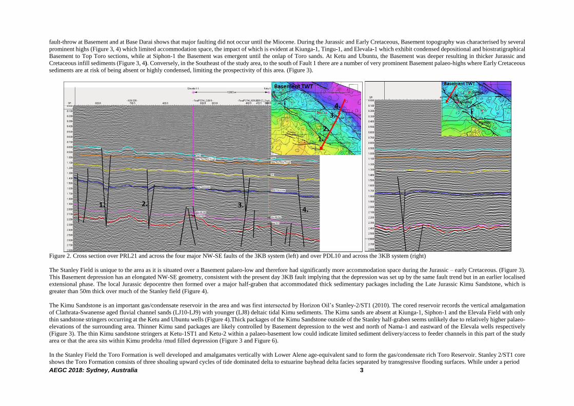
The Stanley Field is unique to the area as it is situated over a Basement palaeo-low and therefore had significantly more accommodation space during the Jurassic – early Cretaceous. (Figure 3).
This Basement depression has an elongated NW-SE geometry, consistent with the present day 3KB fault implying that the depression was set up by the same fault trend but in an earlier localised
extensional phase. The local Jurassic depocentre then formed over a major half-graben that accommodated thick sedimentary packages including the Late Jurassic Kimu Sandstone, which is
greater than 50m thick over much of the Stanley field (Figure 4).
The Kimu Sandstone is an important gas/condensate reservoir in the area and was first intersected by Horizon Oil’s Stanley-2/ST1 (2010). The cored reservoir records the vertical amalgamation
of Clathrata-Swanense aged fluvial channel sands (LJ10-LJ9) with younger (LJ8) deltaic tidal Kimu sediments. The Kimu sands are absent at Kiunga-1, Siphon-1 and the Elevala Field with only
thin sandstone stringers occurring at the Ketu and Ubuntu wells (Figure 4).Thick packages of the Kimu Sandstone outside of the Stanley half-graben seems unlikely due to relatively higher palaeo-
elevations of the surrounding area. Thinner Kimu sand packages are likely controlled by Basement depression to the west and north of Nama-1 and eastward of the Elevala wells respectively
(Figure 3). The thin Kimu sandstone stringers at Ketu-1ST1 and Ketu-2 within a palaeo-basement low could indicate limited sediment delivery/access to feeder channels in this part of the study
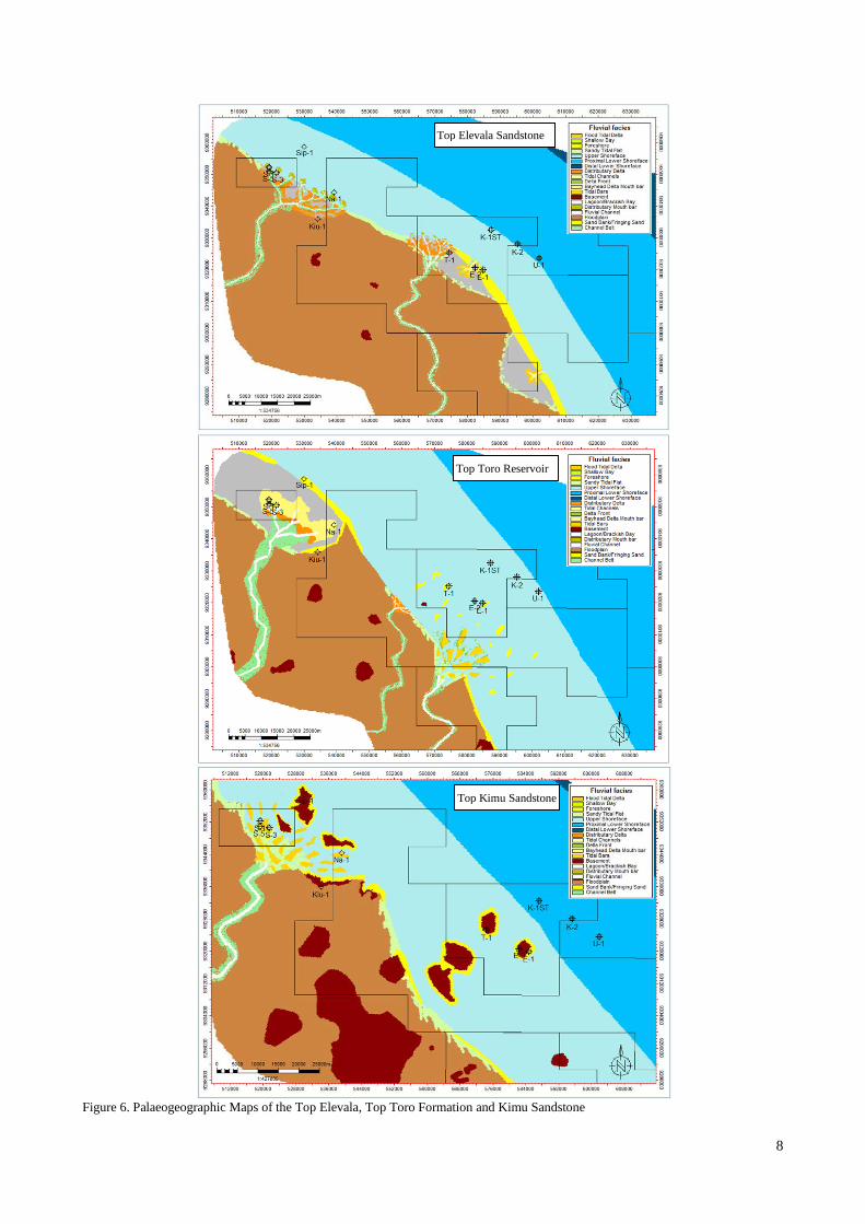
area or that the area sits within Kimu prodelta /mud filled depression (Figure 3 and Figure 6).
In the Stanley Field the Toro Formation is well developed and amalgamates vertically with Lower Alene age-equivalent sand to form the gas/condensate rich Toro Reservoir. Stanley 2/ST1 core
shows the Toro Formation consists of three shoaling upward cycles of tide dominated delta to estuarine bayhead delta facies separated by transgressive flooding surfaces. While under a period
PRL21

AEGC 2018: Sydney, Australia 4
of increasing sea-level the Lower Alene sands were deposited as a distributary mouth bar. The three basinward shifts (Toro A, B C)
are seen throughout PNG and Australia and conform to the major drops in global eustatic sea-level during the Early Cretaceous (Powis,
1993). The structural low in the vicinity of the Stanley field during the Barriasian and Valanginian enabled the development of deltaic
to estuarine systems between the surrounding Basement highs. Robinson and Winn, (1998) suggested sediment from distributary
systems, such as those identified at the Stanley Field, helped establish the NW oriented shoreface belt parallel to the main frontal thrust
of the foldbelt. Around the areas of PRL21 and PRL28 thinner Toro section has been intersected, however, accommodation space
appears to be comparable or greater than the Stanley Field (Figure 4). An integrated study at Elevala-1 by Carter and Ventris (1990)
suggested that this area was a net sand by-pass region due to a lack of subsidence which led to the development of relatively thin deltaic
tidal bars or amalgamated sheet-like sands under periods of lowering sea-level. Potentially the development of thinner Toro sands
could also be due to distributary channels in the PRL21 area relative to the Stanley Field. Proximity to terrestrial influence is evident
in the area with Elevela-1, Elevala-2, Tingu-1, Ketu-2 and Ubuntu-1 palynology data showing relatively high miospore abundance (35-
45%).
Figure 3. Isochrons showing major structural phases across the study area (Contours 40ms). Seismic section illustrates Miocene Phase
3 & 4 in contrast to the tectonically passive PRL21 area.
Phase 2: Initial 3KB displacement (Early Cretaceous)
An initial pulse of N-S faulting over Stanley defines the second Structural Phase (note movement of Stanley 2 and Kiunga-1 in Figure
4). Cretaceous growth of the 3KB fault between Stanley and Kiunga was also noted by McConachie and Lanzilli (2000), and suggests
that the 3KB fault was likely active for much of the Jurassic–Cretaceous period but laterally limited to the PDL10 area (Figure 3). The
well correlation across the Stanley field also supports early tectonism, as indicated by the absence of the Elevala Sandstone and Upper
Alene Member at Stanley-2, Nama-1 and Kiunga-1 (Figure 4). This study is in agreement with Nelson (2011) who proposed that local
N-S tear faulting across the Stanley field was in response to right-lateral Cretaceous strike-slip of the 3KB fault.
The area around PRL21 and PRL28 (Ubuntu-1) was relatively inactive during the Early Cretaceous with accommodation space being
driven by sea-level and Basement architecture. Sedimentological analysis of Elevala-2, Tingu-1 and Ketu-2 cores describe the Elevala
Sandstone as a barrier bar/shoreface system (Figure 6). The Elevala Sandstone is highly correlatable across the Elevala, Ketu and
Ubuntu fields and is comprised of two upward coarsening sandstone lobes that are separated by a ~2m thick transgressive claystone.
The lower Elevala consists of a wave-dominated prograding shoreline, coarsening upwards from a proximal open shelf to an upper
shoreface (K2) to foreshore environments (T1 and E2). The Upper Elevala lobe is generally a marine shoreface succession which
interfingers with thin lagoon deposits in periods of low sediment supply/sea-level rise. Overall the facies are wave dominated, however,
tidal influences increase in the Upper Elevala Sandstone and a distributary system developed at Tingu-1. The prograding nature of the
Elevala Sandstone suggests abundant sediment supply in a period of rising sea-level. However, in areas where sediment supply is
limited, due to the lack of access to sediment dispersal systems, the Elevala sandstone is likely to be less developed.
PRL21 PRL21
PRL21
PDL10
AEGC 2018: Sydney, Australia 5
Figure 4. Correlated cross-section of wells in the study (mTVDss), wells progressively flattened on main structural event horizons.
Flattened Top Toro/ Basement architecture
Flattened Top Alene
Flattened: Near Top Darai
Flattened: Present Day
Flattened: Top Sirga/ Base Darai
Siphon-1 Stanley-1 Stanley-5 Stanley-2 Stanley-4 Stanley-3 Nama-1 Kiunga-1 Tingu-1 Elevala-1 Elevala-2 Ubuntu-1 Ketu-2 Ketu-1ST

AEGC 2018: Sydney, Australia 6
Phase 3: Major 3KB displacement (Early Miocene)
Two significant sinistral wrenching events have been identified from the Cenozoic Era. Collectively they are responsible for the
majority of throw observed across the 3KB fault system today. Seismic interpretation suggests that there were two major episodes of
sinistral strike-slip activity during the Miocene. The first was laterally limited to the Stanley and Kiunga areas, while the second was
more far-reaching and responsible for the tens of metres of normal displacement observed along the bounding faults of the Elevala and
Ketu fields. This section discusses the structural importance of the first of these episodes.
During this initial episode, a release bend north of Kiunga caused a major E-W fault with significant normal displacement (Nelson,
2011; Figure 3). Throw across this fault is recorded at up to 350m in some sections, far surpassing any other mapped faults within the
Fly Strickland Depocentre. This normal displacement does not appear to be accommodated by any proximal smaller scale faulting. As
a consequence, the entire northern region of the Fly-Strickland depocenter appears to have subsided relative to the southern footwall
side resulting in much thicker Darai north of the Kiunga fault (Figure 3).
The same sinistral strike-slip episode is responsible for significant local inversion of the Stanley field which is situated further
Northwest, on a constraining bend. This area has subsequently transformed from a structural low to what is now, a prominent anticline.
The associated local uplift has resulted in significant peneplanation of Miocene carbonate deposits and therefore much thinner Darai
Limestone can be found over the Stanley Field relative to its immediate surrounds (Figure 4).
Phase 4: Kiunga Inversion (Mid-Late Miocene) This period represents the second major phase of 3KB sinistral strike-slip which appears to only affect the Kiunga structure and areas
south of it. In this phase, the recently formed E-W Kiunga fault (Figure 3) appears to be constraining the northern extent of strike-slip
along the 3KB system. Evidence of this phase can be seen in the footwall of Kiunga where a moderate amount of inversion is observed
(Figure 3). This same tectonic event is believed to be responsible for the major NW-SE faulting over the PRL21 area providing faults
of high seal potential that constitutes are a very important component of the structural traps of the Elevala and Ketu fields
Phase 5: Foreland loading (Late Miocene-Pleistocene) Major regional compression of the Late Miocene to Pliocene has led to the development of the New Guinea fold and thrust belt.
Associated foreland loading brought on significant regional north-eastward flexure across the study area which provided a favourable
thermal maturity environment for hydrocarbon expulsion from Jurassic source rocks. Furthermore, an increase in accommodation space
provided by the regional flexure has led to a thickening of Pliocene-Pleistocene Orubadi/Era deposits to the northeast. This
compressional event also enhanced the compactional drape of reservoirs over pre-existing Basement highs and formed the traps of the
Elevala, Ketu, Ubuntu Fields.
The Basement to Upper Darai isochron provides a qualitative illustration of the Basement structure in the Late Miocene prior to the
major NE flexure event (Figure 5). A comparison with the present-day Basement TWT map reveals the extent of flexure; structural
highs that were previously comparable in terms of relative depth have now become significantly deeper to the NE. Over 200m of
flexure has been measured across the PRL21 area alone. This loading event is clearly demonstrated in well section (Figure 4) with
subsidence of the Ketu wells (flattened on present day).
Figure 5. Maps show the impact of foreland loading over the PRL21 area. Basement structure of late Miocene prior to foreland
loading (left) and present day, after regional NE flexure (right).

7
CONCLUSIONS
Integrating Horizon Oil data with the regional database significantly increased the resolution and understanding of the dynamics of the
study area and provided a comprehensive view of the Basement architecture and subsequent tectonic episodes that impacted reservoir
and trap development.
In the study area the 3KB fault system is comprised of four well defined, laterally extensive NW-SE faults. The timing of the various
tectonic episodes along each of these faults, such as accommodating local-scale deformation, and the location of Basement highs was
crucial to the type of trap that formed and the economic viability of the Kimu, Toro and Elevala reservoirs.
Compactional drape over pre-existing Basement highs accounts for the majority of early Cretaceous traps while trap development at
Stanley and to some extent Kiunga, is a function of major early Miocene faulting along the 3KB trend. Basement architecture has had
a critical influence on the deposition of reservoir and source rocks in the region substantiated by thicker Jurassic-early Cretaceous
sedimentary section intersected over Basement palaeo-lows. A detailed synthesis of seismic interpretation, biostratigraphy, well
correlation, core analysis and palynology has increased the understanding of the critical elements of this petroleum system and will aid
in future exploration campaigns.
REFERENCES
Carter, R.R., and Ventris, P., 1990, Sedimentology and Palynofacies of Sequences J/K10 to K30 in well Elevala-1. PPL 81, Papua New
Guinea. BP Petroleum Development Company Limited, London, 1-89
Davey, R.J., 1999 Revised Palynology zonation for the Late Cretaceous, Early Cretaceous and late Jurassic of Papua New Guinea.
Geological Survey of Papua New Guinea Memoir 17, 1-57
Galloway, W.E., 1989, Genetic stratigraphic sequences in basin analysis I; architecture and genesis of flooding surfaces bound units:
AAPG Bulletin, 73, 125-142.
McConachie, A., Lanzilli, E, Kendrick,D., and Burge, C.,2000; Extensions of the Papuan Basin Foreland Geology into Eastern Irian
Jaya (West Papua) and the New Guinea Fold Belt in Papua New Guinea. In Buchanan, P.G., Grainge, A.M., and Thorton, R.C.N. (Eds),
Papua New Guinea’s Petroleum Industry in the 21st Century, Proceedings of the Fourth PNG Petroleum Convention, Port Moresby,
219-237.
McConachie, A., and Lanzilli, E, 2000 Stanley Gas Condensate Field Discovery and the Oil Potential of the Western Papuan Basin. In
Buchanan, P.G., Grainge, A.M., and Thorton, R.C.N. (Eds), Papua New Guinea’s Petroleum Industry in the 21st Century, Proceedings
of the Fourth PNG Petroleum Convention, Port Moresby, 427-442.
Nelson,A.W., 2011, Strike-slip analysis of the Stanley Fault, Papuan Basin, Papua New Guinea. Geosciences Society of New Zealand
Conference Abstracts, 77-78.
Powis, G.D., 1993, The Sequence Stratigraphy of the Mesozoic Reservoirs of the Gobe Anticline, Papuan Trust Belt: In Carman, G.J.
and D. (Eds), Petroleum Exploration and Development in Papua New Guinea, Proceedings of the Second PNG Petroleum Convention,
Port Moresby, 155-167.
Robinson, P and Winn, S., 1998, Mesozoic Sequence Stratigraphy and Paleogeography of the Papuan Foreland. Oil Search Limited
Study-A Joint Study for PRL179, PPL 188, PPL193, and PPL203.
Schofield,S., 2000, The Bosavi Arch and the Komewu Fault Zone: Their Control on Basin Architecture and the Prospectivity of the
Papuan Foreland. In Buchanan, P.G., Grainge, A.M., and Thorton, R.C.N. (Eds), Papua New Guinea’s Petroleum Industry in the 21st
Century, Proceedings of the Fourth PNG Petroleum Convention, Port Moresby, 101-122.
8
Figure 6. Palaeogeographic Maps of the Top Elevala, Top Toro Formation and Kimu Sandstone
Top Elevala Sandstone
Top Toro Reservoir
Top Kimu Sandstone