Embed Size (px)
Citation preview

Stroud DistrictLocal Plan ReviewIssues and Options PaperOctober 2017
Stroud DistrictLocal Plan ReviewIssues and Options PaperOctober 2017
Stroud DistrictLocal Plan ReviewIssues and Options PaperOctober 2017

Development ServicesStroud District CouncilEbley MillStroudGloucestershireGL5 4UB
The Planning Strategy Team01453 [email protected]
visit www.stroud.gov.uk/localplanreview

ContentsLocal Plan ReviewIssues and Options Paper
1
What is this document about? 1How can you get involved? 2Events and exhibitions 3“Parish clusters” 3
1. Key issues 41.1 Economy 51.2 Affordable housing 61.3 Environment 71.4 Health and wellbeing 71.5 Delivery 9
2. Needs 102.1 Local economy and jobs 112.2 Our town centres 142.3 A local need for housing 172.4 Local green spaces and
community facilities19
3. Future growth strategy 203.1 Future growth strategy 213.2 Gloucester’s fringe 243.3 South of the District 263.4 Our towns and villages:
settlement hierarchy28
3.5 Our towns and villages:settlement boundaries
30
3.6 Our towns and villages:broad locations andpotential sites
31
4. Evidence and information 664.1 Background studies 664.2 Image credits and other
sources67

STROUD DISTRICT LOCAL PLAN REVIEW | ISSUES AND OPTIONS 2017 Page | 1
Local Plan Review | Issues and Options paperWhat is this document about?The Stroud District Local Plan identifies thehousing, employment, retail and communitydevelopment that is required to meet local needsup until 2031. It sets out the strategy fordistributing development within the District andpolicies for protecting and conserving the naturaland built environment.
The District Council is now starting the process ofreviewing the current Local Plan. This consultationpaper starts to highlight some of the main issueswe will need to address as part of the review.
Why are we starting thereview now?The Government wants all local authorities toreview their local plans every 5 years. Althoughthe current Plan was approved in November 2015,an early review will ensure that it remains up-to-date and meets future needs for the 20 yearperiod 2016-2036. Plans can take up to 5 years toproduce and so it is important that we start now.
What is our programme?We want to build in to the timetable plenty oftime to discuss issues, options and proposalswith local communities. Setting a realistictimetable upfront helps to provide certaintyfor the future. There will be ongoingengagement with organisations, but the mainpublic consultation activities will be...
The current Local Plan
Issues and options consultation Autumn 2017:An opportunity to discuss emerging issues andidentify ways of distributing and managingfuture development needs.
Preferred options consultation Autumn 2018:We should know much more about quantifyingdevelopment needs by this time and aboutfuture preferred options and alternatives.
Final draft plan consultation Autumn 2019: Afinal chance to check that we have the rightdraft plan in place.
Pre-submission consultation Autumn 2020:The formal stages of making representations onthe plan.
Modifications Summer 2021: Consultation onany proposed modifications to the plan
Adoption: It is anticipated that the new LocalPlan will be adopted by Winter 2021/22.

STROUD DISTRICT LOCAL PLAN REVIEW | ISSUES AND OPTIONS 2017 Page | 2
How can I get involved?The purpose of this issues and optionsconsultation is to understand:-
Which issues relating to the places you live,work or visit in Stroud District are of particularconcern to you today?
Are there matters that are likely to grow inimportance over the next 20 years?
What are the options for addressing them?
We want people to engage early on in the processso that responses can be fed into the next stage ofthe review of the Local Plan.
This issues and options consultation will involve:
Public exhibitions... We are holding nine publicexhibitions around the District during theconsultation period. This will provide anopportunity to chat to officers working on theLocal Plan review. Time and venue details can befound on the following page.
Town and parish council meetings... We will bemeeting with groups of neighbouring town andparish councils to discuss issues across differentparts of the District.
Direct communication... We will be emailingagents, developers, key stakeholders, localinterest groups and members of the public whohave expressed an interest in being kept informed.
Individual groups... We are particularly interestedin making contact with groups and individuals whoare often under-represented in consultationevents, such as community groups and youngpeople. We will be holding bespoke meetings tocapture views. Please contact us if you know of agroup that would like to get involved.
Documents... This document and backgrounddocuments can be accessed through our webpages www.stroud.gov.uk/localplanreview. Youcan view paper copies at the following locations:
Parish council offices open to the public Public libraries Stroud District Council offices, Ebley Mill The Tourist Information Centre at the
Subscription Rooms, Stroud
If you have any queries or suggestions relating tothe consultation please contact the PlanningStrategy team on [email protected] orphone the team on 01453 754143.
How can you make comments?Throughout this document, we pose a number ofquestions, to help focus feedback. You do nothave to answer every question. Please quote thequestion(s) you are answering in anycorrespondence. You can submit your feedbackdirectly to us via our online survey. Alternatively,you can return your comments to us by email orby post.
Submit your comments via our onlinesurvey, or download a response form:www.stroud.gov.uk/localplanreview
Local Plan ReviewThe Planning Strategy TeamStroud District CouncilEbley MillStroud GL5 4UB
Please respond by the closing date of 5thDecember 2017.
@
STROUD DISTRICT LOCAL PLAN REVIEW | ISSUES AND OPTIONS 2017 Page | 3
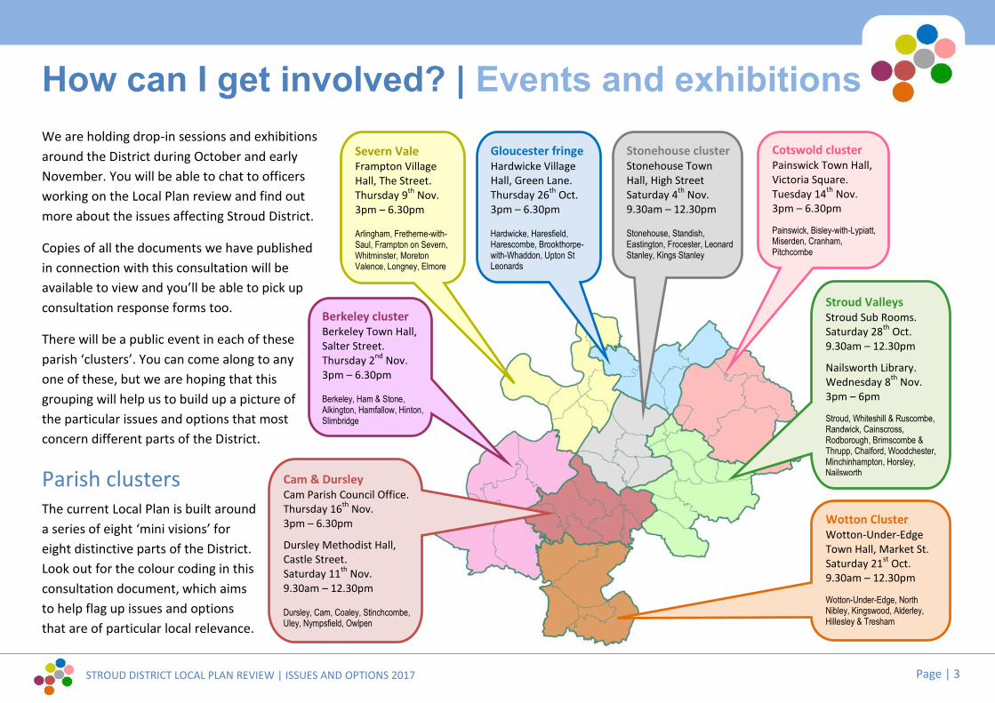
How can I get involved? | Events and exhibitionsWe are holding drop-in sessions and exhibitionsaround the District during October and earlyNovember. You will be able to chat to officersworking on the Local Plan review and find outmore about the issues affecting Stroud District.
Copies of all the documents we have publishedin connection with this consultation will beavailable to view and you’ll be able to pick upconsultation response forms too.
There will be a public event in each of theseparish ‘clusters’. You can come along to anyone of these, but we are hoping that thisgrouping will help us to build up a picture ofthe particular issues and options that mostconcern different parts of the District.
Parish clustersThe current Local Plan is built arounda series of eight ‘mini visions’ foreight distinctive parts of the District.Look out for the colour coding in thisconsultation document, which aimsto help flag up issues and optionsthat are of particular local relevance.
Cotswold clusterPainswick Town Hall,Victoria Square.Tuesday 14th Nov.3pm – 6.30pm
Painswick, Bisley-with-Lypiatt,Miserden, Cranham,Pitchcombe
Stroud ValleysStroud Sub Rooms.Saturday 28th Oct.9.30am – 12.30pm
Nailsworth Library.Wednesday 8th Nov.3pm – 6pm
Stroud, Whiteshill & Ruscombe,Randwick, Cainscross,Rodborough, Brimscombe &Thrupp, Chalford, Woodchester,Minchinhampton, Horsley,NailsworthCam & Dursley
Cam Parish Council Office.Thursday 16th Nov.3pm – 6.30pm
Dursley Methodist Hall,Castle Street.Saturday 11th Nov.9.30am – 12.30pm
Dursley, Cam, Coaley, Stinchcombe,Uley, Nympsfield, Owlpen
Gloucester fringeHardwicke VillageHall, Green Lane.Thursday 26th Oct.3pm – 6.30pm
Hardwicke, Haresfield,Harescombe, Brookthorpe-with-Whaddon, Upton StLeonards
Berkeley clusterBerkeley Town Hall,Salter Street.Thursday 2nd Nov.3pm – 6.30pm
Berkeley, Ham & Stone,Alkington, Hamfallow, Hinton,Slimbridge
Stonehouse clusterStonehouse TownHall, High StreetSaturday 4th Nov.9.30am – 12.30pm
Stonehouse, Standish,Eastington, Frocester, LeonardStanley, Kings Stanley
Wotton ClusterWotton-Under-EdgeTown Hall, Market St.Saturday 21st Oct.9.30am – 12.30pm
Wotton-Under-Edge, NorthNibley, Kingswood, Alderley,Hillesley & Tresham
Severn ValeFrampton VillageHall, The Street.Thursday 9th Nov.3pm – 6.30pm
Arlingham, Fretherne-with-Saul, Frampton on Severn,Whitminster, MoretonValence, Longney, Elmore

STROUD DISTRICT LOCAL PLAN REVIEW | ISSUES AND OPTIONS 2017 Page | 4
1. Key Issues1.1 Economy1.2 Affordable housing1.3 Environment1.4 Health and wellbeing1.5 Delivery

STROUD DISTRICT LOCAL PLAN REVIEW | ISSUES AND OPTIONS 2017 Page | 5
The CorporateDelivery Plan has a 4
year horizon, whilethe current Local Plan
has a developmentstrategy that looks
forward to 2031.
The next Local Planmust try to look even
further into the future.
1. Key issuesThe preparation of the current Local Plan involved the identification of a seriesof key issues, challenges and needs, which the Plan seeks to address. Many ofthose issues remain of relevance today. However, challenges and needs changeover time and priorities for action can change too.
The purpose of this consultation is to understand which issues are of particularconcern to you today in Stroud District, and which matters are likely to grow inimportance over the next 20 years. Are there new issues emerging that weneed to take account of in preparing the next Local Plan?
Building on the key issues set out in the current Local Plan (p9 - 14), and basedon Stroud District Council’s five Key Priorities for making Stroud District abetter place to live, work and visit for everyone (Corporate Delivery Plan 2017-21), we have identified the following priority areas for the review to address:
Economy...Providing for a sustainable and vibrant economy thatworks for all
1. Continuing to provide for job opportunities across theDistrict, with a focus on knowledge based industries,environmental technologies, engineering and manufacturing,creative industries and high quality social care.
2. Rebalancing and regenerating the existing employment stockto secure modern office premises with business supportservices and freehold small industrial sites.
3. Addressing the high level of daily commuting out of and intothe District, particularly out commuting to Bristol,Gloucester, Cheltenham and Swindon.
4. Working with other local authorities and statutory agenciesto investigate transport improvements to link Stroud toBristol, the Midlands and Wales.
5. Improving the vitality and viability of our town centres withina changing environment of regional and on-line shopping.
6. Continuing to develop the tourism potential of our area as aunique selling point for living, working, visiting and investingin the District.
7. Responding to the requirements of the digital economy forsuper- fast broadband connections and good coverage acrossthe District, together with the implications for living andworking patterns.
8. Ensuring that the local economy can respond positively tochallenges and any new trading opportunities following Brexit.

STROUD DISTRICT LOCAL PLAN REVIEW | ISSUES AND OPTIONS 2017 Page | 6
Affordable housing...
Providing affordable, energy efficient homes for a diverseand changing population
9. Meeting the District’s identified future housing needs includingthe particular needs of the elderly and the needs of the travellingcommunities.
10.Working with neighbouring authorities to meet the needs of thehousing market area as a whole.
11.Tackling the acute lack of affordable housing in the District.
12.Ensuring new housing development is located in the right place,supported by the right services and infrastructure to createsustainable development.
13.Providing the right size of accommodation to meet local needs(particularly for smaller, cheaper market and affordable homes)and to help with social cohesion.
14.Ensuring new housing design is flexible and adaptable, to meetthe changing needs of diverse households.
15.Updating existing housing stock across the District, to make itmore fuel efficient, warmer and healthier to live in.
16.Providing opportunities for self-build/custom housing, smallersized developments and new models for housing delivery, todiversify and stimulate the housing market.
17.Maximising the potential of brownfield and underused sites tocontribute to housing supply.
Regeneration...
The current Local Plan identified Ham Mill in Thruppas one of several ‘regeneration sites’ (Policy EI2),where redevelopment should seek to intensifyemployment provision, as well as developing otheruses. A heritage-led scheme was granted planningpermission this year. The mix combines 100 newhomes with modern commercial / employment spaceand the scheme aims to set an architecturalbenchmark, to catalyse regeneration of other under-used industrial heritage sites in the District.
Mixed use redevelopment of Grade II listed Ham Mill by Assael Architecture
Homes...[Below]: Littlecombe in Dursley was a major allocation in the 2005Local Plan. When finished, it will have created about 400 newhomes, 700 new jobs, 200,000sqft of employment buildings and 40acres of green space. [Right]: Stroud District Council is one ofrelatively few local authorities in England to have an active councilhouse building programme.
[3]
[1]
[2]
*[image credits see page 67]
[5] [6]
[7][8]
[4]

STROUD DISTRICT LOCAL PLAN REVIEW | ISSUES AND OPTIONS 2017 Page | 7
Promoting the health and wellbeing of our communitiesand working with others to deliver the public health agenda
27.Maintaining and improving the sustainability of our villages asplaces for living and working, by improving access to services,such as health and education, and jobs.
28.Meeting the needs of young people.
29.Meeting the needs of an increasingly elderly population,enabling people to live independently for longer.
30. Supporting and capitalising on the District’s artistic, cultural andsporting assets.
31. Improving the provision of good quality sports facilities, to meetthe District’s needs and increase participation in sports andphysical activity, particularly among children and young people.
32.Developing a Green Infrastructure network of public open spaceprovision throughout the District, to increase accessibility,ensuring public open spaces are adaptable and capable ofaccommodating multiple uses.
33.Achieving mixed, balanced and cohesive communities offering asense of community identity and belonging, tolerance, respectand engagement with people from different cultures,background and beliefs.
Environment...
Helping the District community minimise its carbonfootprint, adapt to climate change and recycle more
18.Achieving a better transport system, to help reduce CO2 emissions,with an emphasis on limiting car use by extending the cycling andwalking network and making improvements to public transport.
19.Conserving and enhancing Stroud District’s countryside, landscapeand biodiversity, including maximising the potential for a greeninfrastructure network across the District.
20.Mitigating the impacts of climate change, adapting to change andproviding resilience for the future.
21.Protecting and enhancing our historic environment whilst adaptingto modern demands.
22.Promoting high quality and locally distinctive design, incorporatingwhere possible innovative, space efficient and flexible forms formodern living and working.
23.Reconciling the need for energy efficient and low carbon buildingtechnologies and design with the traditional character and localdistinctiveness of places.
24.Contributing to the provision of renewable and low-carbon energygeneration in the District.
25.Providing resilience to flood risk, releasing regeneration sites fromthe floodplain for housing and employment, and promoting naturalflood management projects.
26.Developing strategies to avoid, reduce and mitigate the indirectimpacts of development on the natural environment.
Health and wellbeing...

STROUD DISTRICT LOCAL PLAN REVIEW | ISSUES AND OPTIONS 2017 Page | 8
*[image credits see page 67]
[8]
[10] [11]
Delivery...[16] Neighbourhood
Development Plans are apowerful tool for communitiesto shape the delivery of future
development, to meet theirarea’s specific needs.
Land use...Finding suitable sites and long-term premisesfor sporting facilities can be challenging,especially in the face of competition fromhigher value land uses such as housing.Rush Skate Park has creatively re-used an oldwarehouse in Brimscombe to provide a worldclass indoor skate park, which caters foreverything from international competition tolocal toddlers).
Mitigation...The District’s high quality natural environment isa resource for leisure, health and wellbeing. But
some landscapes and habitats require specialprotections. The District Council worked in
partnership with The National Trust, StroudValleys Project and Natural England to produce
advice as part of the Rodborough CommonMitigation Strategy.
Local disinctiveness...Conservation Area Statements and Village Design Statements are tools to help identifyjust what makes a place ‘distinctive’ in terms of the buildings, spaces, materials andtopography that characterise it.The grass roof and dry stone walling of the new M5 Gloucester Services, nestled belowthe Cotswold escarpment at Brookthorpe, is both unapologetically modern andarchitecturally sensitive in its form, landscaping and palette of materials.
[9]
[12] [13]
[14]
[15]
[20]
[17]
[18][19]

STROUD DISTRICT LOCAL PLAN REVIEW | ISSUES AND OPTIONS 2017 Page | 9
Providing value for money to our tax payers and highquality services to our customers
34.Working with neighbouring authorities to meet the housing,economic and infrastructure needs of the wider market area.
35.Working with public health providers to ensure that health andwellbeing is central to the planning and design of newdevelopment, including the provision of well designed andinsulated homes, the creation of vibrant places, and a network ofopen spaces with opportunities for play, enhanced biodiversityand flood risk resilience.
36.Working with neighbourhood groups to deliver improvements tolocal services and infrastructure, housing and jobs growth at thelocal level, including through Neighbourhood Development Plans.
37.Continuing to ensure that the Cotswolds Canals restoration plays apositive role in the District, bringing health and wellbeing benefitsand enhancing employment opportunities, whilst also conservingthe historic and often rural character of the canal.
38.Ensuring that changes in public sector service delivery providecontinued and improved accessibility to services.
39. Facilitating community infrastructure projects through innovativefunding mechanisms.
40.Developing mitigation strategies to fund environmental projects.
We would like to understand what you believe to be the key issuesrelating to places in the District and future land use needs. Are theybroadly the same as those identified in the current Local Plan? Orare there new issues emerging that we need to take account of inpreparing the new Local Plan?
Question 1.0aWhat are your priorities for Stroud District? Can you list your top 5issues, challenges or concerns for the next Local Plan? You could pickfive from our list of 40... Or tell us if we have missed something.
Question 1.0bDo you have ideas and suggestions for how the Local Plan mighttackle particular issues?
Where can I find out more about the key issues that informedthe current Local Plan?
98 ‘Key issues’ are set out inChapter 1 of the current LocalPlan, covering a range of topics
You can also find morebackground information in theEvidence Base pages of ourwebsite.
www.stroud.gov.uk/localplan
Delivery...

STROUD DISTRICT LOCAL PLAN REVIEW | ISSUES AND OPTIONS 2017 Page | 10
2. Needs2.1 Local economy and jobs2.2 Our town centres2.3 A local need for housing2.4 Local green spaces and community facilities

STROUD DISTRICT LOCAL PLAN REVIEW | ISSUES AND OPTIONS 2017 Page | 11
2.1 Local economy and jobsStroud District has a strong and prosperouseconomy and is home to world class companiesand an innovative, resilient and successful smallbusiness sector. The Council has a commitment towork closely with the business community to growthe local economy and increase employment. Thisis reflected in the Council’s Jobs and Growth Plan.
The Local Plan has a role in providing certainty tothe business community to make long terminvestment decisions, while also providing theframework for creating an attractive environment,including providing for a range and choice of sitesand premises.
One of the key challenges facing the localeconomy of the future is the predicted sharp riseover the next 20 years in the number of olderpeople living in the District compared with thevery small rise in the number of younger people oftraditional working age. Supporting localbusinesses and avoiding skills and job shortageswill require a range of solutions including trying toretain our young people within Gloucestershireand encouraging inward migration. Both of theserequire suitable housing to be available to
discourage long distance commuting to work. Ahigher value economy and better quality jobs willalso be part of the solution.
Question 2.1a
What do you think are the biggest challengesfacing the local economy in Gloucestershire for thefuture? How can we help to address these? DoesStroud District have a specific role to play, relatingto business start ups and specialist technologies orshould we seek to compete with other locations forgrowth?
Sites and premises in the District range from ultramodern, high tech engineering facilities, torestored historic mills and from major industrialsites, covering many hectares, to formeragricultural buildings providing space for microbusinesses in rural areas. The new Local Plan mayneed to allocate further land for employmentuses, to meet business needs from 2031 to 2036,including for local companies, start ups,established companies looking to grow and forcompanies wishing to relocate and invest in thearea.
High Tech...Global engineering companyRenishaw, whose main UK base is atWotton-Under-Edge, has a dedicatedEducation Outreach Officer.
Stroud District Council’sJobs and Growth Plan
Creative...Architectural practice MillarHoward Workshop has baseditself in a former Stroud Valleyswoollen mill. Our area’s richindustrial heritage is fertileground for creative industriesand new start-ups seekingflexible and character-filledwork space.
[1]
[2]
*[image credits see page 67]
[3] © Renishaw

STROUD DISTRICT LOCAL PLAN REVIEW | ISSUES AND OPTIONS 2017 Page | 12
Although the amount and nature of requirementswill be subject to detailed analysis, it would behelpful to understand if there are specific businessrequirements or local employment needs that arenot currently being met within the District due toa lack of suitable sites that the new Local Plancould help deliver.
Question 2.1b
Do you think there is a need for furtheremployment land allocations? If yes what types ofpremises are required and where should they belocated?
The current Local Plan provides for newemployment land located at the key employmentproperty market areas: south of Gloucester;M5/A38 corridor and Stroud Valleys. Theseinclude areas adjoining existing successfulbusiness parks at Quedgeley East (Hardwicke),Severn Distribution Park (Sharpness) andStroudwater Business Park (Stonehouse), togetherwith areas next to proposed new housing at NorthEast Cam and West of Stonehouse.
The Local Enterprise Partnership has a focus onthe M5 corridor as a location for growth reflectingthe good connections via the motorway network
to the Midlands and the South West. Although theLocal Plan allocated land at Quedgeley East nearM5 junction 12 in the District, other employmentallocations represented more incremental growthadjoining existing sites within or on the edge ofour towns to provide employment close to wherelocal people live.
Question 2.1c
Do you think locating growth adjacent to M5junctions should be supported; or wouldcontinuing expansion of employment land atexisting settlements/sites be preferable?
The current Local Plan identifies 36 existing ‘key’employment sites that are to be retained only foroffices, industrial or warehousing uses (known asB class uses). Another 9 sites are identified aspotential regeneration sites, where mixed useredevelopment would be allowed. Increasinglyemployment sites are the preferred location for amix of occupiers, such as retail, gyms, cafes, hotelaccommodation etc. Government policy hasaimed to relax restrictions around change of use,mainly with the aim of increasing housing supply,but also between commercial uses.
While there is a need to ensure that existing sitescan cater for the requirements of businesses inthe B use classes there may be a case for relaxingrestrictions further to allow other employmentgenerating uses on more employment sites.However, sometimes this can create conflictsbetween the needs of businesses and those usesopen to the general public.
Question 2.1d
Should there be increased flexibility to allow otherjob generating uses on all employment sites orwould this limit the options for those companiesoperating in the B classes?
Should increased flexibility be allowed only onsome sites? Please specify any sites where a moreflexible approach could be taken.
Alternatively, a percentage threshold, in terms ofunits or site floorspace, could be identified for nonB class employment uses, which might help toprovide services to other businesses?
Stroud District has above average levels of selfemployment and home working. Changes inworking practices, linked to the roll out of fastbroadband, could see a further increase in homeworking and potentially a decrease in therequirement for large scale office space,

STROUD DISTRICT LOCAL PLAN REVIEW | ISSUES AND OPTIONS 2017 Page | 13
something that is in relative short supply withinthe District anyway. While highlighting thenecessity for the deployment of superfastbroadband across the District, this trend couldpotentially see an increase in the demand for co-working space, where facilities, desks etc. areshared by a number of, usually, self employed andhome based workers; or live-work units, which arespecifically designed to accommodate separatework facilities as well as residentialaccommodation.
Question 2.1e
Should the Local Plan look to promote furtherhome working, encourage development of live-work units and co working facilities? Is there aspecific need in your area?
Structural changes to the pattern of farming haveseen many farms diversifying to include otheremployment enterprises on site. Whilst these canhelp to sustain existing farm businesses and localemployment, they can also create adverse impactson the landscape, local roads and to localcommunities. In the future there is the possibilityof a reduction in agricultural subsidies leading topressures for further diversification including on
arable farms which are typically within theCotswolds.
Question 2.1f
Should the Local Plan look to promote further farmdiversification to reflect changing farmingpractices and to avoid rural dereliction, or does thepattern of rural development need more control toavoid further adverse impacts on the countryside,landscape and local communities?
Co-working...Stroud District has above average levels of
self-employment and home-working. Co-working premises such as SpaceHoppers in
Stroud and Cluster in Chalford cleverlycater to this market, providing not just adesk or a meeting room, but interaction
and support for individuals who mightotherwise feel isolated in their work.
USP...Stroud District has exceptionalnatural, cultural and heritagecapital. Marketing our area’s‘unique selling points’ not onlyboosts tourism, but may helpto draw re-locating or start-upbusinesses to the District andto increase the District’sappeal as a place to live andwork. [6]
[3]
[4]
[5]
*[image credits see page 67]

STROUD DISTRICT LOCAL PLAN REVIEW | ISSUES AND OPTIONS 2017 Page | 14
2.2 Our town centresNationally, shopping patterns have changedsignificantly since the 1970s. The rise of the out oftown supermarkets and retail parks in the 1980sstarted a decline in the traditional role of highstreets providing for all of our shopping needs.The more recent onset of e-retailing in all itsforms: click and collect; home deliveries; andonline shopping has provided a new and growingchallenge. Services such as banks, buildingsocieties and estate agents are closing with thecontinued growth of on–line banking and webbased services where a presence on the highstreet is no longer required.
However, there is also a positive story to tell withthe rise in local food stores and food outlets,giving evidence to the trend of a newly emergingfood and cafe culture. This is reinforced by thetrend for increased ‘eating out’. A further factormay be the growth in interest in locally sourcedand organic foods and also the trend towardshealthy eating.
The ongoing pattern of change suggests that forsmaller centres such as those within our District,town centre strategies which support theevolution of the high street are vital so we can
capitalise on what makes our town centresdistinctive and unique.
A recent Future of Town Centres report which haslooked at the top tier town centres of Stroud,Dursley, Nailsworth, Stonehouse and Wotton-under-Edge is suggesting the following options forhelping our town centres to meet thesechallenges:
Supporting existing retailers to make betteruse of websites and e-retailing to widen theirappeal and increase footfall
Marketing our town centres on-line for theirleisure and tourism potential
Reviewing town centre car parking charges
Reviewing town centre planning policies andboundaries to reflect a smaller future retailarea and to be more flexible to encourageother uses into town centres
Supporting small town centre office useswhich provide work spaces with flexible rentalarrangements
These recommendations equally may apply toother town centres in the District.
*[image credits see page 67]
Niche...How will our town centresadapt in the future? Will theyhave to pursue their own nicheor ‘unique selling point’? Howcan the planning process helpthe District’s town centres tothrive in the face of changingretail practices?
[1]

STROUD DISTRICT LOCAL PLAN REVIEW | ISSUES AND OPTIONS 2017 Page | 15
StroudStroud is by far the biggest shopping centre in theDistrict, with nearly three times as many retailpremises as the next biggest town. However,Stroud has a small food store offer and a non foodsector that may be under threat by the potentialwithdrawal of national retailers, the impact of e-retail and competing larger regional centres. Theforecast is a reduction in demand for non foodfloorspace and the service sector. However, thesuccess of the weekly farmers market and themarked growth of the leisure sector perhapssignpost a refining of the future function of thetown. Possible options for improving the towncentre include:
Marketing the town as a centre for arts andcrafts, food and proximity to the CotswoldsWay
Supporting new housing in the town centrefor “young professionals”
Capitalising on canal side opportunities
Relaxing parking restrictions in the evening toboost the night time economy
Better signage to assist motorists with findingcar parking
Implementing proposals in theNeighbourhood Plan for the development ofsites for housing and town centre uses
NailsworthThe second biggest retail centre in the District,Nailsworth functions as a local centre withevidence that the town is becoming a leisurecentre with specialist food, cafes restaurants, giftshops and independent small fashion retailers.The loss of the local bank recently reflects nationaltrends but vacancy levels are low. Possible optionsfor improving the town centre include:
Establishing a marketing strategy and longterm town centre plan
Better coordination of highwaysimprovements with town centre plans
Improving the town square area with therefurbishment/ redevelopment of retail units,enhancing open spaces and provision ofapartments above shops
DursleyDursley functions as a local centre with a solidfood and non food base. Although there havebeen bank closures and a rise in vacancies duringthe previous recession, there is evidence too of arise in leisure uses in the centre. Possible optionsfor improving the town centre include:
Marketing the town for its tourism potentialdue to its attractive landscape setting andlocation on the Cotswolds Way
Intensifying use of the historic Market Hall asa focus for local events and markets
Enhancing the signage in the town forpedestrians and cyclists
Better signage to assist motorists with findingcar parking
Wotton-under-EdgeWotton functions as a local centre with a stablefood and non food base. Although there havebeen bank closures there is evidence too of a risein leisure uses in the town centre. However,vacancy levels have risen. Possible options forimproving the town centre include:

STROUD DISTRICT LOCAL PLAN REVIEW | ISSUES AND OPTIONS 2017 Page | 16
Marketing the town for its tourism potentialas a southern historic gateway to theCotswolds
Finding a solution for the lack of car and coachparking, including allocating a site
StonehouseThe smallest of the town centres, with a stablefood and non food retail offer. The overall numberof leisure uses has grown but there has been amarked reduction in service uses such as banks.Possible options for improving the town centreinclude:
Marketing the town for its proximity to theA38/M5 corridor and as an entrance to theStroud valleys
Enhancing cycle and footpath links fromStroud and along the canal corridor to thecentre
Enhancing signage from the A419/M5 todirect visitors to the town centre
Question 2.2
Do you agree with the options set out forimproving our town centres? Have we missed anyimportant options? What do you consider to bethe most important actions to undertake?
*[image credits see page 67]
[2]
[3] [4] [5] [6]
[7] [8]

STROUD DISTRICT LOCAL PLAN REVIEW | ISSUES AND OPTIONS 2017 Page | 17
2.3 A local need for housingThe review of the Local Plan provides theopportunity to consider whether there arehousing needs in our neighbourhoods that aren’tcurrently being catered for by the market. Whilemany households aspire to owning their ownhome, not everyone will be able to achieve this inthe short term, especially younger households orthose on modest incomes living in our moreexpensive rural villages.
The 2017 Government White Paper Fixing OurBroken Housing Market gives the followingexample of the growing gap between earnings andhouse prices:
As recently as the 1990s, a first-time buyer coupleon a low-to-middle income, saving five per cent oftheir wages each month, would have enough foran average-sized deposit after just three years.Today it would take them 24 years. It’s no surprisethat home ownership among 25- to 34-year-oldshas fallen from 59 % just over a decade ago to just37 % today.
As a result, the rented sector is of growingimportance in Stroud District, as it is elsewhere in
the country. But many of our parishes show a lackof smaller or more modestly priced propertiesavailable to rent.
At the opposite end of the spectrum, older peoplecan find themselves to be asset rich but incomepoor; trapped in larger properties that areunsuitable for them but with limited opportunitiesto move to a more suitable home, whilstremaining within the same, often cherished,community.
Options could include allocating sites for newhousing to meet specific local needs.
There is also growing interest in self-buildopportunities; not just for expensive ‘granddesigns’ but from households with a desire tomake the most of their available funds to createhomes that are relatively cheaper and bespoke totheir family’s needs.
Options could include allocating sites specificallyfor self-build housing for people with a localconnection.
Local housing solutions may require local deliverymechanisms and there is currently considerableinterest in exploring the potential of co-operativesand community land trusts to address local needs.
Question 2.3a
Tell us about housing needs and opportunities inyour area:
Does your neighbourhood provide opportunitiesfor local people to access the housing market,bearing in mind the growing gap between localincomes and house prices?
Are there opportunities in your area forhouseholds to rent reasonably-priced properties?
Are younger people in your neighbourhood able toaccess housing without moving elsewhere?
If older people in your neighbourhood wished todownsize to smaller, more suitable properties inthe area, are these opportunities likely to exist?
Would individuals or small groups be able to locatesuitable land for self-build projects in theneighbourhood?
Do you know of other unmet housing needs in yourneighbourhood?

STROUD DISTRICT LOCAL PLAN REVIEW | ISSUES AND OPTIONS 2017 Page | 18
If we don’t do anything to address gaps in thehousing market, there is a risk that youngerpeople will abandon rural neighbourhoods ingrowing numbers. This leads to these placesstagnating and losing local services, eventuallybecoming enclaves of elderly people who riskbecoming isolated and finding it increasinglydifficult to access essential local trades such asbuilders and plumbers, or people able to providehelp with the home and garden.
New properties can be designed to be easilyadapted to suit older people, or those withdisabilities, by having level access to the frontdoor and space available inside to fit downstairsshowers or through-floor lifts. Design standardssuch as this, known as ‘lifetime homes’, could bepromoted through the Local Plan review,alongside other flexible accommodation designssuch as flats with easily removable partition wallsso that they can be adapted from one bedroom totwo – and back again.
One option to help us focus on a community’sspecific needs and how they might be met, is touse a local housing needs survey. This is a surveydone to assess need at a parish level, and can helpidentify the type, tenure and cost of housingneeded in a parish. Currently these surveys can beused as evidence to bring forward rural exception
sites for affordable housing, but there could bescope to use them to influence otherdevelopments, too.
Question 2.3b
Do you think that local housing need surveysshould also be used to influence the housing mixon local for-sale housing sites?
Question 2.3c
Do you know of any suitable land for developmentto meet the housing needs of your neighbourhood,or do you have suggestions about how or wherethese needs might be met?
If you would like to know more about how toinvestigate local housing need, please contact us.
01453 754099
Housing Strategy, Development Services, StroudDistrict Council, Ebley Mill, Stroud, Glos. GL5 4UB
www.stroud.gov.uk/housing/housing-strategy
Local need...Residents have been able to moveinto brand new Council homescompleted in Cam this year. Likemany places in the UK, housingaffordability is a particular issue foryoung families and first time buyersacross the District. Nationally, homeownership among 25- to 34-year-olds has fallen from 59 % just over adecade ago to just 37 % today.
Annexes and adaptations...How should the next Local Plan
approach planning and design issuesaround annexes for dependants or
carers, or the adaptation of homes tomeet changing needs over a lifetime?
[1]
[2]
*[image credits see page 67]

STROUD DISTRICT LOCAL PLAN REVIEW | ISSUES AND OPTIONS 2017 Page | 19
2.4 Local green spaces and communityfacilitiesThe review of the Local Plan provides theopportunity to consider whether there are localcommunity needs within existing towns andvillages that are not currently being provided for.The loss of public houses, village shops and otherfacilities can often leave communities withoutplaces to meet and enjoy together. A more activeor growing community can need more or differingplay and sports facilities. Sometimes developmentcan offer opportunities to deliver new communityfacilities in places where existing deficiencies exist.
Equally, there may be existing places and spacesthat are valued by the community but are notexplicitly recognised in existing plans. Existingcommunity facilities can be identified forprotection. Local green spaces can be identifiedfor special protection. These are local areas ofparticular importance to local communities fortheir beauty, tranquillity and/or historic, wildlifeor recreation value but should not involveextensive tracts of land.
Question 2.4a
Does your neighbourhood lack a particular form ofcommunity facility, open space or sports facility? Ifso we would like to know about that need.
Question 2.4b
Are there existing facilities or local spaces that youconsider important for protection? If so please tellus and explain why they are of particularimportance.
Play...The recently completed Horsley PlayProject was first dreamed up 6 yearsago by local parents. Working with theParish Council, the project securedfunding from several sponsors toupdate facilities and re-landscape thespace so that it now meets the needs ofthe community and caters for a widerage range, as well as providingenhanced habitats for wildlife.
[1]
[2]
*[image credits see page 67]

STROUD DISTRICT LOCAL PLAN REVIEW | ISSUES AND OPTIONS 2017 Page | 20
3. Future growth strategy3.1 Future growth strategy3.2 Gloucester’s fringe3.3 South of the District3.4 Our towns and villages | settlement hierarchy3.5 Our towns and villages | settlement development limits3.6 Our towns and villages | broad locations and potential sites

STROUD DISTRICT LOCAL PLAN REVIEW | ISSUES AND OPTIONS 2017 Page | 21
[1] Concentrated development?
Concentrating mixed-use development close to theDistrict’s larger settlements means new residents are ableto access existing services and facilities. Meanwhile, therelatively large scale of each new development may meanthat new facilities and amenities (e.g. a new primaryschool, public open spaces, community orchard orallotments, a doctor’s surgery, nursery, neighbourhoodshops) can be integrated alongside new homes and jobs –which benefits the existing settlement’s community aswell as occupants of the new development.
RightHow might this kind of growth strategy impact at local
level, with significant mixed-use development areasattached to existing communities?
3.1 Future growth strategyThe amount of future housing and employmentgrowth needed for the Local Plan review period2016-2036 has yet to be identified and we will beworking with our neighbouring authorities toquantify these needs over the next 12 months.However, it is important that potential strategiesfor distributing future growth and potentiallocations and supply options are thoroughlyinvestigated at this early stage.
Much of the future development is expected tocontinue to come forward within our current townand villages, either through the redevelopment ofexisting so-called “brownfield” sites or throughinfill development. However, it is not possible forall future needs to be met this way.
The current Local Plan allocates land for housingand employment development on the edge ofCam, south of Gloucester, at Stonehouse,
at Sharpness and in the Stroud Valleys. Thebenefits of this kind of concentrated developmentstrategy [1] include locating new residents close toplaces with the most facilities, services and jobs.Larger developments also provide more scope forcreating a mix of uses and for funding newinfrastructure needed by the new communities.However, large sites can take a long time to bedeveloped and it can be challenging to integratethese sites into the existing local area.
Note: these images are purely illustrative and are not based on any settlements in Stroud District
[1][1]

STROUD DISTRICT LOCAL PLAN REVIEW | ISSUES AND OPTIONS 2017 Page | 22
An alternative strategy could be to plan for a greater number of smaller andmid-sized housing and employment sites, distributed to the larger villages inaddition to the main towns [2]. This would provide more opportunities todeliver some new housing closer to where local needs are generated,although it is unlikely that a mix of uses could be achieved on every site.
The opposite of the current strategy would be to implement a wider dispersalstrategy, identifying at least one site for housing and potentially foremployment at most villages even with a limited level of facilities [3]. Whilstthis might be an attractive way of organically growing existing settlements, itis unlikely that this pattern would overcome existing deficiencies in terms oflocal service provision.
[2] Wider distribution?Smaller and mid-sized housing or employment
allocations at the District’s towns and larger villagesare able to respond to local needs and might bringabout some limited additional benefits, such ascommunity open spaces.
[3] Dispersal?A wider dispersal strategy, where small housing or
employment sites are located at most of theDistrict’s settlements, offers a more organic way of
integrating future growth into existing communitiesand meeting very local housing and employmentneeds. However, such small scale development is
unlikely to sustain ailing services and facilities andwould not deliver significant service or infrastructure
improvements for the community.
Tier 1 settlements: the District’s main towns
Tier 2 settlements: secondary towns and larger villages
Tier 3 settlements: villages with limited facilities
Tier 4 or 5 settlements: smaller villages and hamlets
Settlements that will experience growth
Growth and development areas / scale of growth
[2]
[3]
[3]
[2]
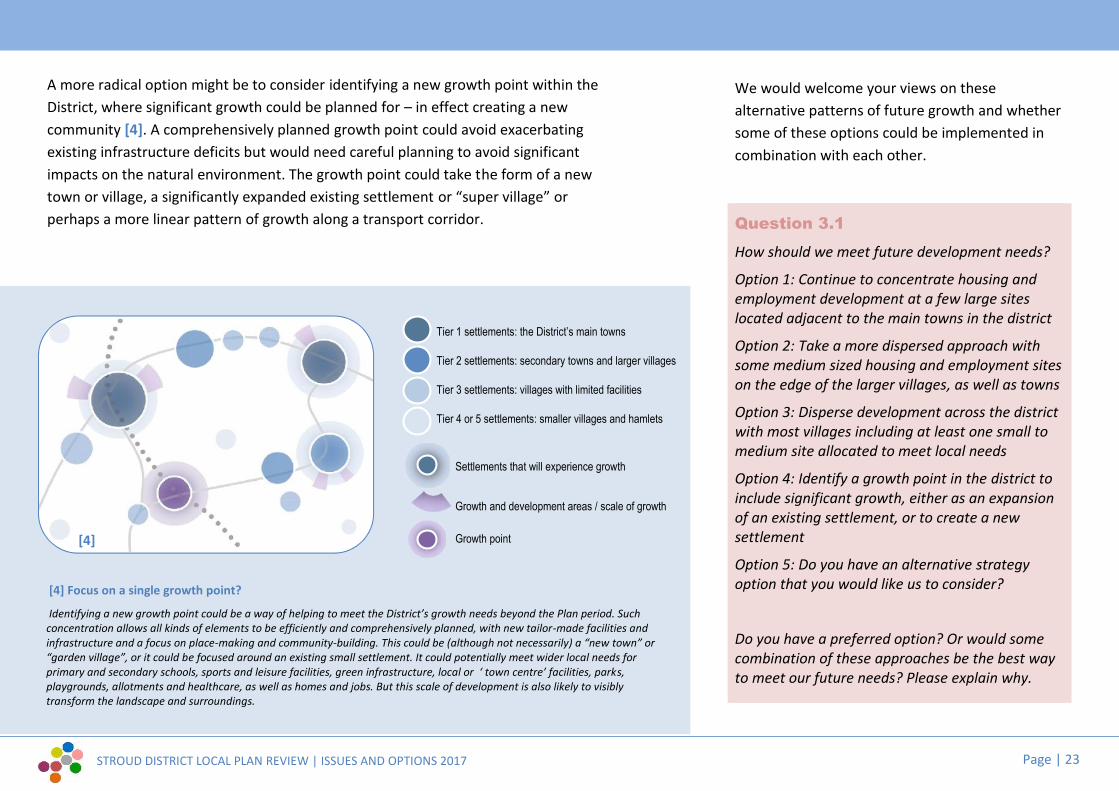
STROUD DISTRICT LOCAL PLAN REVIEW | ISSUES AND OPTIONS 2017 Page | 23
[4] Focus on a single growth point?
Identifying a new growth point could be a way of helping to meet the District’s growth needs beyond the Plan period. Suchconcentration allows all kinds of elements to be efficiently and comprehensively planned, with new tailor-made facilities andinfrastructure and a focus on place-making and community-building. This could be (although not necessarily) a “new town” or“garden village”, or it could be focused around an existing small settlement. It could potentially meet wider local needs forprimary and secondary schools, sports and leisure facilities, green infrastructure, local or ‘ town centre’ facilities, parks,playgrounds, allotments and healthcare, as well as homes and jobs. But this scale of development is also likely to visiblytransform the landscape and surroundings.
A more radical option might be to consider identifying a new growth point within theDistrict, where significant growth could be planned for – in effect creating a newcommunity [4]. A comprehensively planned growth point could avoid exacerbatingexisting infrastructure deficits but would need careful planning to avoid significantimpacts on the natural environment. The growth point could take the form of a newtown or village, a significantly expanded existing settlement or “super village” orperhaps a more linear pattern of growth along a transport corridor.
[3]
Tier 1 settlements: the District’s main towns
Tier 2 settlements: secondary towns and larger villages
Tier 3 settlements: villages with limited facilities
Tier 4 or 5 settlements: smaller villages and hamlets
Settlements that will experience growth
Growth and development areas / scale of growth
Growth point
We would welcome your views on thesealternative patterns of future growth and whethersome of these options could be implemented incombination with each other.
Question 3.1
How should we meet future development needs?
Option 1: Continue to concentrate housing andemployment development at a few large siteslocated adjacent to the main towns in the district
Option 2: Take a more dispersed approach withsome medium sized housing and employment siteson the edge of the larger villages, as well as towns
Option 3: Disperse development across the districtwith most villages including at least one small tomedium site allocated to meet local needs
Option 4: Identify a growth point in the district toinclude significant growth, either as an expansionof an existing settlement, or to create a newsettlement
Option 5: Do you have an alternative strategyoption that you would like us to consider?
Do you have a preferred option? Or would somecombination of these approaches be the best wayto meet our future needs? Please explain why.
[4]

STROUD DISTRICT LOCAL PLAN REVIEW | ISSUES AND OPTIONS 2017 Page | 24
3.2 Gloucester’s fringeThe very northern part of the District, includingthe settlements of Hardwicke and Upton St.Leonards, adjoins the city of Gloucester. There is aclose relationship between the two areas, withmany of the facilities and services that supportresidents living within the District located withinor on the southern edge of Gloucester.
A new local plan is being finalised that covers theGloucester City, Tewkesbury Borough andCheltenham Borough areas, known as the JointCore Strategy. This plan identifies that in thelonger term additional sites will be required tomeet Gloucester’s housing needs beyond 2028.These could include sites within the Gloucesterurban area, but might also include sites on theedge of Gloucester, either in Tewkesbury Boroughand/or Stroud District or elsewhere within theGloucestershire housing market area.
Landowners and developers are promoting landwithin the Gloucester fringe as potential sites forfuture housing and employment development tomeet some of Gloucester’s future needs and/orneeds arising from within the District. One view isthat these sites are relatively unconstrained, for
example not being within the Green Belt. Analternative view is that there may be moresuitable sites located closer to Gloucester citycentre to the north, northwest and east ofGloucester.
Stroud District Council is committed to workingwith Gloucester City and other adjoiningauthorities to identify the most sustainable sitesto meet Gloucester’s future needs. Your initialviews on the suitability of the broad locationswithin Stroud District that are identified on themap (over the page) are welcome; and we wouldlike to know whether you think there are otherlocations that should also be considered.
If development does occur at one or more ofthese locations, there may be opportunitiesthrough a masterplanning process to create amore permanent landscaped southern boundaryto Gloucester and to protect the local characterand setting of existing villages on the fringes ofGloucester within the District.
Question 3.2aWe welcome views on whether the followingbroad locations should be considered fordevelopment, if needed, or whether you canidentify better sites in Stroud District or inneighbouring areas that should be assessed:
G1 South of Hardwicke (housing/community uses)G2 Whaddon (for housing/ employment/
community uses)G3 South west of Brockworth (for housing/
community uses)G4 South of M5/J12 (for employment uses)
Question 3.2bCould any further development help to establish afirm southern landscaped boundary to the city, ineffect a “rounding off” of the urban area, or wouldit simply exacerbate further sporadic growth?
Question 3.2cAre there any specific community needs arisingfrom Hardwicke, Haresfield, Brookthorpe,Whaddon or Upton St. Leonards that could be metin these areas; and what safeguards could be putin place to protect the local character and settingof existing villages?

STROUD DISTRICT LOCAL PLAN REVIEW | ISSUES AND OPTIONS 2017 Page | 25
SEE HARDWICKESETTLEMENT MAP p52
SEE UPTON ST LEONARDSSETTLEMENT MAP p53
G1
G2
G4
G3
Hunts Grove
Brockworth
© Crown copyright and database rights 2017 Ordnance Survey 100019682
Gloucester fringe
Stroud Districtboundary
Gloucester City andTewkesbury Borough
Cotswolds AONB
Flood zones 2 and 3
Natural environmentconstraints (includingkey wildlife sites, SSSI,ancient woodland)
Existing strategy (currentLocal Plan):
Settlementdevelopment limits
Existing growth areas(site allocations incurrent local plan)
Existing employmentareas (keyemployment sites)
Growth areas plannedprior to the currentLocal Plan (HuntsGrove and Brockworth)
Potential Growth:
Potential broadlocations for housing,employment and/orcommunity facilities
SALA sites with somefuture potential
Rejected SALA sites
Planned housinggrowth (GloucesterCity)
G1

STROUD DISTRICT LOCAL PLAN REVIEW | ISSUES AND OPTIONS 2017 Page | 26
3.3 South of the DistrictThere is a clear relationship between settlementson the southern edge of the District and SouthGloucestershire and Bristol further south. Forexample, the Bristol housing market area extendsto include Wotton-under-Edge and southern partsof the Severn Vale. In addition, many residentsliving in the area commute southwards along theM5 and A38 to Thornbury, Yate, Bristol andbeyond for work.
The West of England authorities are currentlypreparing a Joint Spatial Plan. The emergingspatial strategy is proposing future housinggrowth at Charfield and Buckover Garden Village,together with transport improvements at M5Junction 14, the potential reopening of Charfieldstation and Metrobus and rural busimprovements.
Previous public consultations have identified localconcerns within the District around the impact ofgrowth at Charfield on local traffic, the localenvironment and on local services, particularly,within Wotton-under-Edge. However, growth mayalso provide opportunities to improve transport
connections north and south and to deliver new orextended local services.
Question 3.3a
We welcome views on whether there areopportunities to improve transport links betweenareas within Stroud District and SouthGloucestershire, Bristol and beyond; or to providenew local services; and what development withinthe District might be appropriate to deliver these.
Question 3.3b
We welcome views on the most appropriatelocations for housing and employment growth onthe southern edge of Stroud District. Current Tier 2settlements in the area are Berkeley and Wotton-under-Edge.
The current Local Plan identifies land at SharpnessDocks both for new employment growth and fornew housing to support a tourism and leisurerelated regeneration scheme for the northerndocks. Beyond this, there may be opportunities forfurther housing and employment growth at thislocation, taking advantage of underused
infrastructure in the local area and potentiallydelivering improved transport links to the A38, M5and mainline railway network. However, there areconstraints at Sharpness, including flooding issuesand a sensitive estuarial landscape and habitatthat would need careful handling. Any larger scalegrowth would need to consider the relationshipwith existing communities, particularly atWanswell and Brookend.
Question 3.3c
Do you consider that there is more potential forfurther growth at Sharpness/Newtown? What arethe opportunities and are there any potentialbarriers to growth?
Question 3.3d
We would also like to know whether there arespecific community needs arising from Berkeley,Wanswell and Brookend that could be met atSharpness/Newtown; and what safeguards couldbe put in place to protect the local character andsetting of existing villages.

STROUD DISTRICT LOCAL PLAN REVIEW | ISSUES AND OPTIONS 2017 Page | 27
Tier 1 settlements: Cam and Dursley
Tier 2 settlements: secondary towns and larger villages
Tier 3 settlements: villages with limited facilities
Tier 4 & 5 settlements: smaller villages
Town centres
Existing growth areas (siteallocations in the current Local Plan)
Existing employment areas(including Key Employment Sitesand Regeneration Sites)
Potential Growth:
Potential broad locations for housing,employment and/or community facilities
West of England Emerging Spatial Plan:
Bristol housing market area
Existing settlements in South Glos.
Proposed strategic developmentlocation
Likely transport mitigations to include:
Junction improvements includingM5 J14
New rail station
Strategic transport improvements
SEE NEWTOWN/SHARPNESSSETTLEMENT MAP p55
SEE BERKELEYSETTLEMENT MAP p54
SEE CAM & DURSLEYSETTLEMENT MAPS p48 / p50
Sharpness DocksNewtown
Berkeley
Wotton-Under-Edge
THORNBURY
CAM
DURSLEY
Charfield
Wickwar
Kingswood
Slimbridge
Uley
North Nibley
SEE WOTTONSETTLEMENT MAP p61
SEE KINGSWOODSETTLEMENT MAP p59
Buckover
Berkeley Wotton Cam & DursleyParish cluster Parish cluster Parish cluster
Existing strategy (current Local Plan):
Berkeley GreenUniversity TechnicalCollege
SOUTHGLOUCESTERSHIRE
COTSWOLDDISTRICT
Falfield
Stroud Districtboundary
Cotswolds AONB
Severn Estuary habitatarea
M5 Motorway
‘A’ Roads
Railway (existing railstation at Cam &Dursley)
Sharpness branch line(freight only)
Sharpness Canal
A38
M5
A4135
A46
© Crown copyright and database rights 2017 Ordnance Survey 100019682
South of the District

STROUD DISTRICT LOCAL PLAN REVIEW | ISSUES AND OPTIONS 2017 Page | 28
3.4 Our towns and villages | Settlement hierarchyMost of the need for new homes and jobs inStroud District is generated by the existingpopulation. Only a small number of homes andjobs are required by people arriving from outsideof the District. It is therefore important that theLocal Plan identifies opportunities for futuregrowth at existing towns and villages where mostpeople currently live and work.
The current Local Plan identifies a hierarchy ofsettlements, with the largest towns (containingthe best range of services and facilities)considered to be the most appropriate locationsfor significant levels of new homes and jobs. Bycontrast, the smallest settlements (containingminimal facilities) are not identified to receive anygrowth, other than specific needs identified inNeighbourhood Plans.
The evidence for this hierarchy is contained withina Settlement Role and Function Study thatcompares each town and village against a range ofcriteria, including settlement size, employmentrole, access to retail and community facilities.
The current Local Plan ‘hierarchy’ is as follows:
Tier / Settlement: Level of growth:
1 Cam & Dursley, Stonehouse, StroudPrimary focus for growth, toprovide significant levels ofjobs and homes.
2 Berkeley, Frampton on Severn, Hunts Grove,Minchinhampton, Nailsworth, Wotton under Edge
Potential to provide modestlevels of jobs and homes.
3 Amberley, Bisley, Brimscombe, Chalford, Coaley,Eastington, Hardwicke, Horsley, Kings Stanley,Kingswood, Leonard Stanley, Manor Village,Newtown & Sharpness, North Nibley, NorthWoodchester, Oakridge Lynch, Painswick,Slimbridge, Uley, Upton St. Leonards, Whiteshill &Ruscombe, Whitminster.
Potential to provide lesserlevels of development.
4 Box, Brookthorpe, Bussage, Cambridge,Eastcombe, France Lynch, Middleyard, Newport,Nympsfield, Randwick, Selsley, SouthWoodchester, Stinchcombe, Stone, Thrupp
Limited scope fordevelopment to meet specificneeds.
5 Arlingham, Cranham, Haresfield, Hillesley,Longney, Saul, Sheepscombe
Very limited development tomeet specific needs.

STROUD DISTRICT LOCAL PLAN REVIEW | ISSUES AND OPTIONS 2017 Page | 29
Whilst the hierarchy reflects the current functionof each town or village it does not reflect theenvironmental constraints that affect manysettlements. For example, whilst Stroud maycontain the most facilities in the District, futuregrowth is severely constrained by landscapefactors. Conversely, some smaller settlementshave more options for growth, for example, due totheir location outside the Cotswolds Area ofOutstanding Natural Beauty (AONB) and flood riskareas. Should the hierarchy be amended to reflectenvironmental constraints?
The current approach identifies the descriptivelevel of growth considered appropriate at eachtier of town or village, relative to othersettlements; but is not prescriptive in terms of theamount of growth. For example, “primary”,“modest”, “lesser”, “limited” or “very limited”levels of growth are not quantified. An alternativeapproach might be to specify the minimum ormaximum growth levels envisaged at each town orvillage, in terms of homes and/or jobs, based uponan assessment of local needs and capacity toaccommodate growth. This might be a morequasi-scientific approach, but may be tooprescriptive if opportunities or constraints notcurrently envisaged were to occur in the future.
Question 3.4
Do you agree with the current hierarchy-basedapproach towards identifying settlements suitablefor different levels of development? Is there adifferent approach you would prefer?
Do you agree with the different tiers identified inthe current Local Plan and the scale ofdevelopment proposed for each tier?
Are any of the settlements in the wrong tier and, ifso, for what reason?
Where can I find out more about the role andfunction of particular settlements?
You can find ourSettlements Role andFunction Study in theEvidence Base pages ofour website
www.stroud.gov.uk/localplan

STROUD DISTRICT LOCAL PLAN REVIEW | ISSUES AND OPTIONS 2017 Page | 30
3.5 Our towns and villages | Settlement boundariesThe current Local Plan manages growth on theedge of settlements by supporting developmentwithin tightly defined settlement developmentlimits but resisting most forms of developmentbeyond, except for a limited range of types ofdevelopment defined as acceptable within thecountryside.
The Plan argues that this approach providescertainty for the market and local communitiesand minimises urban sprawl, but it can be seen astoo prescriptive and lacking flexibility to assessindividual proposals. The Local Plan review offersthe potential to reassess current settlementdevelopment limits or to consider a differentapproach.
One alternative approach might be to rely oncriteria to judge the suitability of development,rather than whether a site lies within or outside aline on a map. For example, assessing a proposalby looking at landscape impact, setting of heritageassets, form of settlement, etc. Another approachmight be to maintain settlement developmentlimits but to widen the type of development thatis suitable on the edge of settlements but outside
the limits, for example to give support to smallerdevelopments such as barn conversions, live workunits, exemplar carbon neutral schemes, etc.
Question 3.5a
How should development proposals on the edgesof our towns and villages be managed?
Option 1: Continue with existing settlementdevelopment limits amended as necessary
Option 2: Assess proposals on a case by case basisusing broader criteria (e.g. landscape impact; formof settlement, proximity to services, etc.)
Option 3: Continue with settlement developmentlimits but expand the types of development thatare allowed beyond them in the countryside
Option 4: Do you have an alternative approachthat you would like us to consider?
You may have suggestions for minor changes toexisting settlement development limits either toprevent unsuitable development or to allow forsome limited development to create a better edgeto a town or village.
Question 3.5b
Are there any changes to existing settlementdevelopment limits that you would like to suggest?
Where can I see the current settlementdevelopment limits?The existing settlement boundaries are definedon the current Local Plan maps. You can accessthese and an interactive online mapping tool viaour local plan web page:
www.stroud.gov.uk/localplan
Earthstar Geographics, CNES/Airbus DS | (C) Crown copyright and databaserights 2017 Ordnance Survey 100019682 | OS, Esri, HERE, Garmin
© Crown copyright and database rights 2017 Ordnance Survey 100019682

STROUD DISTRICT LOCAL PLAN REVIEW | ISSUES AND OPTIONS 2017 Page | 31
3.6 Our towns and villages | Broad locations andpotential sitesWhilst some settlements may be suitable in termsof facilities and services for additional housing,employment or community facilities, not alllocations may be suitable because of physicalconstraints or potential impacts, for example,many of our settlements are located within areasknown for their landscape beauty or for theirbiodiversity. However, additional open space maybe appropriate.
In preparation for this consultation, the DistrictCouncil has undertaken an initial broadassessment of land around the main towns andthe larger villages in Stroud District – thoseidentified in the current Local Plan as Tier 1, Tier 2and Tier 3 settlements. Potential sites put forwardby landowners, developers and parish councilshave been assessed. Where it has been possibleto identify potential broad locations for futuregrowth, these are set out. Only the areas shown inpurple are considered to have future potential.The detailed site specific results are set out withinthe 2017 Strategic Assessment of LandAvailability (SALA).
Please note that the identification of broadlocations and sites in this document is for thepurposes of public consultation only. It does notindicate Council support for development atthese locations.
We would like to know your views on whether, iffuture housing, employment or community usesare required, we have identified the best broadlocations at each settlement and whether any ofthe SALA sites may be suitable. Alternatively, youmay wish to suggest a different location and/orsite for consideration.
At this stage, we have not looked at small villagesand hamlets (Tier 4 and 5 settlements) because ofthe very limited or minimal range of local servicesand facilities there. However, we would welcomesuggestions if you believe any village or hamletnot mentioned in this consultation paper couldbenefit from future development and, if so, whattype of development and where it could beaccommodated.
Question 3.6
Read through the settlement summaries over thefollowing pages and tell us whether you agreewith the potential broad locations for growth, iffuture housing, employment or communityfacilities are needed. Where more than onelocation is identified you can tell us which is thebest option.
You may identify an alternative or additionallocation or site by indicating so on a map.
You may also identify broad locations or sites atsmaller villages that you think are appropriate forsome development.
In all cases, please specify whether the site isappropriate for housing, employment, retailand/or community uses including open space.

STROUD DISTRICT LOCAL PLAN REVIEW | ISSUES AND OPTIONS 2017 Page | 32
www.stroud.gov.uk/localplan
Where can I find the SALA report?
You can find our 2017Strategic Assessmentof Land Availability(SALA) in the EvidenceBase pages of ourwebsite
3.6 Broad locations and potential sites: give us your views...
Are you interested in a specific settlement? Over the following pages, the settlement summaries are groupedinto ‘parish clusters’ (see p3) and are then ordered alphabetically by settlement name.
If future development is needed at a particular settlement, do you agree with thepotential broad locations for future growth that are shown on the map?
YesIf you agree, you don’t necessarily need tocomment, but you may wish to tell us why youagree, or if there are more than one potentialbroad location, which is the best option.
NoPlease explain why you disagree with some or allof a potential location for future growth.
(You may also reference a specific SALA site).
Visit stroud.gov.uk/localplanreview to submit your written comments ordownload a response form to send via post or email.
The maps show potential sites that were considered through the 2017SALA process.
If you have useful evidence about a specific site or if you would like tosuggest an alternative broad location for growth or to promote anadditional site (including at smaller settlements not covered by thesettlement summaries), please submit your written comments as above,accompanied by a map.
Would you like to identifyan alternative broadlocation for growth or topromote an alternativesite?
Please attach a mapalong with your writtencomments. The siteboundary and / or yourproposed broad locationfor growth must be clearlymarked on your map.
p33 p44 p48 p52 p54 p57 p59 p62
Key to settlement maps
Existing settlement development limit(settlement boundary)
Potential broad location for future growth
SALA sites with some future potential
Rejected SALA sites
Heritage constraints (includingconservation areas, listed buildings,scheduled monuments...)
Natural environment constraints(including key wildlife sites, ancientwoodland, SSSI, RAMSAR...)
The Cotswolds AONB
Flood zones 2 and 3
Site allocations in the current Local Plan
A

STROUD DISTRICT LOCAL PLAN REVIEW | ISSUES AND OPTIONS 2017 Page | 33
The Stroud Valleys | Broad locations and potential sites
Planning constraints and designations
Physical constraints include the steeptopography on the partly wooded westernvalley sides.
The Amberley Conservation Area covers thewhole of the village. There are a number oflisted buildings within the village and on theboundaries. Minchinhampton Common onthe eastern boundary is designated as aScheduled Ancient Monument.
Minchinhampton Common is also a Site ofSpecial Scientific Interest (SSSI) which includesland to the east and west of the village. Thereare Tree Preservation Orders (TPO) on thewestern edge of the village.
The Cotswolds AONB designation covers all ofthe village and surrounding land.The village is identified in the Local Plan as aThird Tier settlement and has settlementdevelopment limits.
Landscape sensitivityThe landscape parcels around the settlementare all considered to be of high sensitivity toboth housing and employment uses and donot offer any opportunity for housing oremployment allocation in terms of landscapeand visual factors.
Accessibility
The settlement is identified as an AccessibleSettlement with Limited Facilities in theLocal Plan.
There is no significant retail role and a basiclevel of services and facilities.
Access to services and facilitieselsewhere is rated good.
Amberley accommodates a smallnumber of jobs.
Broad locations for future growthThere are no identified locations for growthat Amberley.
Limited infill development within settlementdevelopment limits and other developmentappropriate to the settlement’s rurallocation is expected to continue.
Sites with future potentialNo SALA sites were promoted at Amberley.
...Amberley
© Crown copyright and database rights 2017 Ordnance Survey 100019682

STROUD DISTRICT LOCAL PLAN REVIEW | ISSUES AND OPTIONS 2017 Page | 34
The Stroud Valleys | Broad locations and potential sites
Planning constraints and designations
Physical constraints include the floodplainthat runs along the River Frome valley; thesteep topography on the valley sides andbrownfield site conditions.
The Industrial Heritage Conservation Arearuns through the settlement. There are anumber of listed buildings principally relatedto former mills located along the river.
The River Frome Key Wildlife Site lies alongthe river and canal corridor. There are anumber of unimproved grassland Key WildlifeSites located on the northern slopes.
The Cotswolds AONB surrounds thesettlement on three sides.
There is a protected open space to the west.The settlement is identified in the Local Planas a Third Tier settlement and has settlementdevelopment limits.
Landscape sensitivityLandscape sensitivity indicates that there areonly limited opportunities for housing,including an enclosed field to the south of thesettlement; and there is no identifiedpreferred direction for employment growth.
Accessibility
The settlement is identified as an AccessibleSettlement with Limited Facilities in theLocal Plan.
There is a basic level of local retail provisionand a limited range of local communityservices and facilities.
Access to services and facilitieselsewhere is rated fair.
Brimscombe accommodates a largenumber of jobs.
Broad locations for future growthThere may be the following broad locationsfor further growth around the settlement,should growth be required:
BRI A Brimscombe Mill
BRI B Brimscombe Port / Bourne Mills
BRI C Dockyard Works
BRI D Brimscombe Farm (for housingand/or community uses only)
Sites with future potentialSites identified through the 2017 SALA areshown on the map (right). Sites outlined inred may have future potential. Sites outlinedin blue are considered unsuitable or notavailable.
...Brimscombe
A BCD
© Crown copyright and database rights 2017 Ordnance Survey 100019682

STROUD DISTRICT LOCAL PLAN REVIEW | ISSUES AND OPTIONS 2017 Page | 35
The Stroud Valleys | Broad locations and potential sites
Planning constraints and designations
Physical constraints include the Frome valley-bottom floodplain; steep valley-sidetopography; and brownfield site conditions.
Four conservation areas cover the south andwest of the settlement: the IndustrialHeritage Conservation Area; Chalford Vale; StMary’s & Belvedere; Chalford Hill. Many listedbuildings along the canal/river corridor andwithin Chalford Hill CA.
River Frome and Thames & Severn Canal KeyWildlife Sites (KWS) on the valley bottom(within settlement). To the east, south andwest, Ancient Woodland and four other KWSadjoin or lie close to the settlement.
Within the Cotswolds AONB.
Four protected play spaces lie to the east(three at Burcombe Way; one in the GoldenValley)The settlement is identified in the Local Planas a Third Tier settlement and has settlementdevelopment limits.
Landscape sensitivity
The preferred direction of housing growth inlandscape terms is to the northwest.
There is no identified preferred direction ofemployment growth in landscape terms.
Accessibility
The settlement is identified as an AccessibleSettlement with Limited Facilities in theLocal Plan.
There is a basic level of local retail provision,and a limited range of local communityservices and facilities.
Access to services and facilitieselsewhere is rated poor.
Chalford accommodates a largenumber of jobs.
Broad locations for future growthThere may be the following broad locationsfor further growth around the settlement,should growth be required:
CHA A West of Middle Hill (for housingand/or community uses only)
Sites with future potentialSites identified through the 2017 SALA areshown on the map (right). Sites outlined inred may have future potential. Sites outlinedin blue are considered unsuitable or notavailable.
...Chalford
A
© Crown copyright and database rights 2017 Ordnance Survey 100019682

STROUD DISTRICT LOCAL PLAN REVIEW | ISSUES AND OPTIONS 2017 Page | 36
The Stroud Valleys | Broad locations and potential sites
Planning constraints and designations
The principal physical constraint is thefloodplain to the east of the settlement.
There are a number of listed buildingsincluding the church, Horsley Court and anumber of dwellings.
The Sandgrove Cottages and Hartley BridgeWood Key Wildlife Site wraps around thesouth east corner.
The settlement is within the Cotswolds AONB.
There is a protected open space to thesouthwest.
The settlement is identified in the Local Planas a Third Tier settlement and has settlementdevelopment limits.
Landscape sensitivity
Landscape sensitivity indicates that there isonly limited opportunity for housing growth,along the B4056.
There is no identified preferred direction ofemployment growth in landscape terms.
Accessibility
The settlement is identified as an AccessibleSettlement with Limited Facilities in theLocal Plan.
Horsley has no significant retail role (there isa village shop), but provides a reasonablerange of local services and facilities.
Access to services and facilitieselsewhere is rated fair.
Horsley has the smallest number ofjobs of any Tier 1-3 settlement.
Broad locations for future growthThere may be the following broad locationsfor further growth around the settlement,should growth be required:
HOR A South of The Street (for housingand/or community uses only).
Sites with future potentialSites identified through the 2017 SALA areshown on the map (right). Sites outlined inred may have future potential. Sites outlinedin blue are considered unsuitable or notavailable.
...Horsley
A
© Crown copyright and database rights 2017 Ordnance Survey 100019682

STROUD DISTRICT LOCAL PLAN REVIEW | ISSUES AND OPTIONS 2017 Page | 37
The Stroud Valleys | Broad locations and potential sites
Planning constraints and designations
Physical constraints include the steep valley-side topography to the northwest.
The Brownshill & Bussage Conservation Areaabuts the western side of the settlement andEastcombe Conservation Area abuts thenorth. Chalford Hill Conservation Area liesvery nearby to the southeast.
Frith Wood, (designated as Ancient Woodlandand a Key Wildlife Site) is a significantintrusion into the southern part of thesettlement.
The settlement is within the Cotswolds AONB.
There is protected outdoor play space at bothschools within the settlement and furthersites lie north east at Middle Hill andsouthwest at The Frith.The settlement is identified in the Local Planas a Third Tier settlement and has settlementdevelopment limits.
Landscape sensitivity
The preferred direction of housing growth inlandscape terms is to the northeast andsecondarily to the southwest, close to thesettlement edge.
There is no identified preferred direction ofemployment growth in landscape terms.
Accessibility
The settlement is identified as an AccessibleSettlement with Limited Facilities in theLocal Plan.
There is a basic level of local retail provision,and a limited range of local communityservices and facilities.
Access to services and facilitieselsewhere is rated fair.
Manor Village accommodates amedium number of jobs.
Broad locations for future growthThere may be the following broad locationsfor further growth around the settlement,should growth be required:
MAN A East of Middle Hill (for housingand/or community uses only)
Sites with future potentialSites identified through the 2017 SALA areshown on the map (right). Sites outlined inred may have future potential. Sites outlinedin blue are considered unsuitable or notavailable.
...”Manor Village”
A
© Crown copyright and database rights 2017 Ordnance Survey 100019682

STROUD DISTRICT LOCAL PLAN REVIEW | ISSUES AND OPTIONS 2017 Page | 38
The Stroud Valleys | Broad locations and potential sites
Planning constraints and designations
The principal physical constraint isMinchinhampton Common, which extends tothe north and east of the settlement.
Minchinhampton Common is designated as aScheduled Ancient Monument and SSSI.
Minchinhampton Conservation Area coversthe centre of the town. There are numerouslisted buildings within and to the north andsouth of the settlement, together with theBulwarks Scheduled Ancient Monument onthe eastern edge.
The settlement is within the Cotswolds AONB.
There are protected open spaces within andto the west of the town.
The town is identified in the Local Plan as aSecond Tier settlement and has settlementdevelopment limits.
Landscape sensitivity
The preferred direction of housing growth inlandscape terms is to the east.
There is no identified preferred direction ofemployment growth in landscape terms.
Accessibility
The settlement is identified as a LocalService Centre in the Local Plan.
The town has a limited strategic role butoffers an excellent level of local services andfacilities.
Access to services and facilitieselsewhere is rated poor.
Minchinhampton accommodates alarge number of jobs.
Broad locations for future growthThere may be the following broad locationsfor further growth around the settlement,should growth be required:
MIN A South of Cirencester Road (forhousing and/or community uses only)
MIN B East of Tobacconist Road (forhousing and/or community uses only)
Sites with future potentialSites identified through the 2017 SALA areshown on the map (right). Sites outlined inred may have future potential. Sites outlinedin blue are considered unsuitable or notavailable.
...Minchinhampton
AB
© Crown copyright and database rights 2017 Ordnance Survey 100019682

STROUD DISTRICT LOCAL PLAN REVIEW | ISSUES AND OPTIONS 2017 Page | 39
The Stroud Valleys | Broad locations and potential sites
Planning constraints and designations
The principal physical constraint is thefloodplain to the east and south of thesettlement along the River Frome Valley
The Industrial Heritage Conservation Areacovers the eastern edge of the settlementcontaining listed buildings.
The settlement is surrounded by the CotswoldAONB.
There are protected open spaces scatteredaround the settlement.
The settlement is identified in the Local Planas a Second Tier settlement and hassettlement development limits.
Landscape sensitivity
The preferred direction of housing growth inlandscape terms is to the west.
Small areas within the valley bottom offer theonly opportunities f or employment growth.
Accessibility
The settlement is identified as Local Servicecentre in the Local Plan.
Nailsworth offers a reasonable range of“strategic” facilities, as well as a full range of“local” services. Nailsworth has a strongcommunity role in meeting the needs of othersettlements.
Accessibility (contd...)
Access to services and facilitieselsewhere is rated fair.
Nailsworth accommodates a very largenumber of jobs.
Broad locations for future growthThere may be the following broad locationsfor further growth around the settlement,should growth be required:
NAI A North of Nympsfield Road/Nortonwood junction (for housing and/orcommunity uses only)NAI B South of Lower Newmarket Road (forhousing and/or community uses only)NAI C North of Avening Road (foremployment only)
Sites with future potentialSites identified through the 2017 SALA areshown on the map (right). Sites outlined inred may have future potential. Sites outlinedin blue are considered unsuitable or notavailable.
...Nailsworth
A
BC
© Crown copyright and database rights 2017 Ordnance Survey 100019682

STROUD DISTRICT LOCAL PLAN REVIEW | ISSUES AND OPTIONS 2017 Page | 40
The Stroud Valleys | Broad locations and potential sites
Planning constraints and designations
The principal physical constraint is thefloodplain to the east of the settlement alongthe River Frome valley
The Industrial Heritage Conservation Areacovers the eastern edge of the settlement andSouth Woodchester Conservation Area lies tothe south. There are numerous listedbuildings in and around the settlement; andWoodchester Roman Villa, a ScheduledAncient Monument, adjoins it to the north.
The Nailsworth Brook Key Wildlife Site (KWS)lies to the east of the settlement and RabbitWarren Wood KWS beyond to the west.
The north west and the eastern edge of thesettlement are within the Cotswold AONB.
There is a protected open space to the south.
The settlement is identified in the Local Planas a Third Tier settlement and has settlementdevelopment limits.
Landscape sensitivityLandscape sensitivity indicates that the onlypotential for housing growth is to thenorthwest, for a few well spaced propertieswith indented edge, west of Lawns Park.
The only potential for employment growthmay be to the north, where very smallcommercial premises may be acceptableadjoining the existing buildings.
Accessibility
The settlement is identified as an AccessibleSettlement with Limited Facilities in theLocal Plan.The settlement has no significant retail role(there is a village convenience store), butprovides a good range of local services andfacilities.
Access to services and facilitieselsewhere is rated very good.
North Woodchester accommodates amedium number of jobs.
Broad locations for future growthThere may be the following broad locationsfor further growth around the settlement,should growth be required:
NWO A West of Lavins Park (for housingand/or community uses only)
NWO B Rooksmoor Mill
Sites with future potentialSites identified through the 2017 SALA areshown on the map (right). Sites outlined inred may have future potential. Sites outlinedin blue are considered unsuitable or notavailable.
...North Woodchester
A
B
© Crown copyright and database rights 2017 Ordnance Survey 100019682

STROUD DISTRICT LOCAL PLAN REVIEW | ISSUES AND OPTIONS 2017 Page | 41
The Stroud Valleys | Broad locations and potential sites
Planning constraints and designationsPhysical constraints include the River Fromefloodplain; the steep valley topography andbrownfield site conditions.There are multiple conservation areas: EbleyMills; Industrial Heritage; Lodgemore &Fromehall; Stroud Station; Top of Town andTown Centre. Many listed buildings withinand near to the town centre and alongriver/canal corridor.Rodborough Common SAC / SSSI to the south.Key Wildlife Sites (KWS): River Frome KWSalong the river corridor; Bisley RoadCemetery, The Folly, The Horns Bank andWood and Slade Wood KWSs to the east.Rodborough Fields KWS to the south of thecentre. Nailsworth Brook KWS to the south.The Cotswolds AONB surrounds the town.There are protected open spaces within thetown.The town is a First Tier settlement and hassettlement development limits.
Landscape sensitivity
Landscape sensitivity indicates that there arelimited options for housing growth, butmodest interventions may be possible withinparcels to the west; north east and southeast. Small scale interventions are possiblewithin the canal corridor. If employmentgrowth is necessary, there are only very smallscale options within the canal corridor.
Accessibility
The town is identified as an Accessible LocalService Centre in the Local Plan.
The settlement has a strategic retail role andis the District’s principal town centre. There isalso a good level of local retail services tosupport its satellite communities.
The settlement has the most extensive rangeof strategic (e.g. further education college andhospital) and local services and facilities asthe District’s principal service town.
Stroud’s access to services and facilitieselsewhere is the best in the District.
Stroud accommodates the largest numberof jobs of any Tier 1-3 settlement.
Broad locations for future growthThere may be the following broad locations for further growtharound the settlement, should growth be required:
STR A Central river / canal corridor:
A1 Rear of Avocet business park
A2 Lodgemore / Fromehall Mills / Lower Wharf
STR B South of Stroud:
B1 Daniels Industrial Estate
B2 Bath Road Industrial Estate (for employment only)
STR C West of Devereaux Crescent (for housing and/or communityuses only)STR D North of Grange View/Delmont Grove (for housing and/orcommunity uses only)
Sites with future potentialSites identified through the 2017 SALA are shown on the followingmap (over the page). Sites outlined in red may have futurepotential. Sites outlined in blue are considered unsuitable or notavailable.
...Stroud

STROUD DISTRICT LOCAL PLAN REVIEW | ISSUES AND OPTIONS 2017 Page | 42
The Stroud Valleys | Broad locations and potential sites
D
C
B2 B1
A1 A2
...Stroud
© Crown copyright and database rights 2017 Ordnance Survey 100019682

STROUD DISTRICT LOCAL PLAN REVIEW | ISSUES AND OPTIONS 2017 Page | 43
The Stroud Valleys | Broad locations and potential sites
Planning constraints and designations
Physical constraints include the steeptopography on the valley sides and woodedareas to the north and west.
There are listed buildings within the villagesand on the southern edge of Whiteshill.
There is ancient woodland to the north westof Ruscombe. There are three Key WildlifeSites: Ruscombe Woods to the north west;The Throat Meadows and Quarry to the northand Ruscombe Meadows between thevillages. There are TPOs on the southern andwestern edge of Whiteshill
The Cotswolds AONB designation covers all ofthe villages and surrounding land.
There is a protected open space to the westof Whiteshill.The villages are identified in the Local Plan asThird Tier settlements and have settlementdevelopment limits.
Landscape sensitivityThe landscape parcels around the settlementare all considered to be of high sensitivity toboth housing and employment uses and donot offer any opportunity for housing oremployment allocation in terms of landscapeand visual factors.
Accessibility
The settlements are identified as AccessibleSettlements with Limited Facilities in theLocal Plan.
There is a basic level of local retail provisionand a reasonable range of local services andfacilities.
Access to services and facilitieselsewhere is rated very good.
Whiteshill & Ruscombe accommodateone of the smallest numbers of jobs ofany Tier 1-3 settlement.
Broad locations for future growthThere are no identified locations for growthat Whiteshill & Ruscombe.
Limited infill development within settlementdevelopment limits and other developmentappropriate to the settlement’s rurallocation is expected to continue.
Sites with future potentialNo SALA sites were promoted at Whiteshill& Ruscombe.
...Whiteshill & Ruscombe
© Crown copyright and database rights 2017 Ordnance Survey 100019682
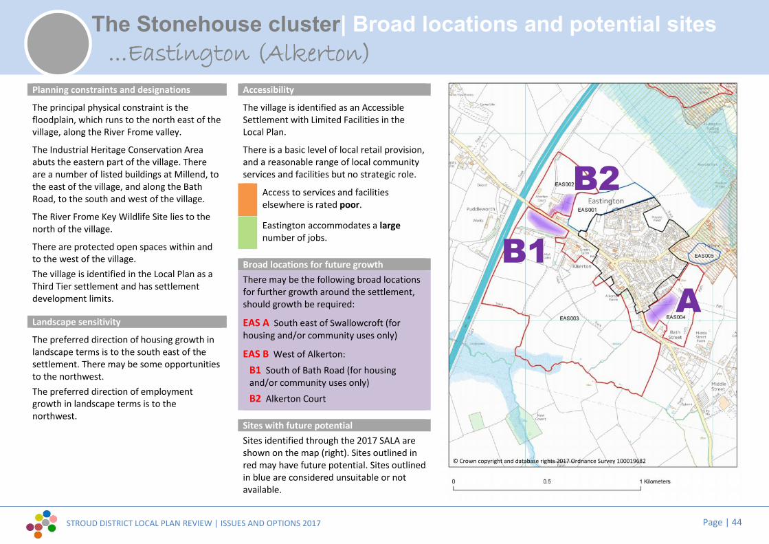
STROUD DISTRICT LOCAL PLAN REVIEW | ISSUES AND OPTIONS 2017 Page | 44
The Stonehouse cluster| Broad locations and potential sites
Planning constraints and designations
The principal physical constraint is thefloodplain, which runs to the north east of thevillage, along the River Frome valley.
The Industrial Heritage Conservation Areaabuts the eastern part of the village. Thereare a number of listed buildings at Millend, tothe east of the village, and along the BathRoad, to the south and west of the village.
The River Frome Key Wildlife Site lies to thenorth of the village.
There are protected open spaces within andto the west of the village.The village is identified in the Local Plan as aThird Tier settlement and has settlementdevelopment limits.
Landscape sensitivity
The preferred direction of housing growth inlandscape terms is to the south east of thesettlement. There may be some opportunitiesto the northwest.The preferred direction of employmentgrowth in landscape terms is to thenorthwest.
Accessibility
The village is identified as an AccessibleSettlement with Limited Facilities in theLocal Plan.
There is a basic level of local retail provision,and a reasonable range of local communityservices and facilities but no strategic role.
Access to services and facilitieselsewhere is rated poor.
Eastington accommodates a largenumber of jobs.
Broad locations for future growthThere may be the following broad locationsfor further growth around the settlement,should growth be required:
EAS A South east of Swallowcroft (forhousing and/or community uses only)
EAS B West of Alkerton:
B1 South of Bath Road (for housingand/or community uses only)B2 Alkerton Court
Sites with future potentialSites identified through the 2017 SALA areshown on the map (right). Sites outlined inred may have future potential. Sites outlinedin blue are considered unsuitable or notavailable.
...Eastington (Alkerton)stington (Alkerton
A
B2
B1
© Crown copyright and database rights 2017 Ordnance Survey 100019682

STROUD DISTRICT LOCAL PLAN REVIEW | ISSUES AND OPTIONS 2017 Page | 45
The Stonehouse cluster| Broad locations and potential sites
Planning constraints and designations
The principal physical constraint is thefloodplain to the north of the village along theRiver Frome valley.
The Industrial Heritage Conservation Areaabuts the northern part of the village. Thereare a number of listed buildings within thevillage and on the northern and easternboundaries.
The River Frome Key Wildlife Site abuts thevillage to the north.
The Cotswolds AONB lies immediately to theeast and south of the village.
There are protected open spaces within thesettlement.The village is identified in the Local Plan as aThird Tier settlement and has settlementdevelopment limits.
Landscape sensitivity
The preferred direction of housing growth inlandscape terms is to the north of thesettlement. There may be some smallopportunities to the south and east.
The preferred direction of employmentgrowth in landscape terms is to the north.
Accessibility
The settlement is identified as an AccessibleSettlement with Limited Facilities in the Plan
There is a good level of local retail provision,and a good range of local communityservices and facilities.
Access to services and facilitieselsewhere is rated fair.
Kings Stanley accommodates a smallnumber of jobs.
Broad locations for future growthThere may be the following broad locationsfor further growth around the settlement,should growth be required:
KST A Stanley Mills (for housing and/orcommunity uses only)
KST B North of Primary School (for housingand/or community uses only)
KST C Rear of Borough Close (for housingand/or community uses onlyKST D Brunsdons Yard (for employmentonly)
Sites with future potentialSites identified through the 2017 SALA areshown on the map (right). Sites outlined inred may have future potential. Sites in blueare considered unsuitable or not available.
...Kings Stanley
A D
C
BD
© Crown copyright and database rights 2017 Ordnance Survey 100019682

STROUD DISTRICT LOCAL PLAN REVIEW | ISSUES AND OPTIONS 2017 Page | 46
The Stonehouse cluster| Broad locations and potential sites
Planning constraints and designations
There are no significant physical constraints.
There are a number of listed buildings withinand to the south west of the village.
The River Frome Key Wildlife Site lies beyondthe village to the north.
The Cotswolds AONB lies beyond the south ofthe village.
There are protected open spaces within thesettlement.The village is identified in the Local Plan as aThird Tier settlement and has settlementdevelopment limits.
Landscape sensitivity
The preferred direction of housing growth inlandscape terms is to the north andnorthwest of the settlement.
There is no identified preferred direction ofemployment growth in landscape terms.
Accessibility
The settlement is identified as an AccessibleSettlement with Limited Facilities in theLocal Plan.
The settlement has no retail facilities andrelies on those within neighbouring KingsStanley. There is a reasonable range of localcommunity services and facilities.
Access to services and facilitieselsewhere is rated fair.
Leonard Stanley accommodates one ofthe smallest numbers of jobs of anyTier 1-3 settlement.
Broad locations for future growthThere may be the following broad locationsfor further growth around the settlement,should growth be required:
LEO A North of Bath Road (for housingand/or community uses only)
LEO B Severn Waters (for housing and/orcommunity uses only)
Sites with future potentialSites identified through the 2017 SALA areshown on the map (right). Sites outlined inred may have future potential. Sites outlinedin blue are considered unsuitable or notavailable.
...Leonard Stanley
AB
© Crown copyright and database rights 2017 Ordnance Survey 100019682
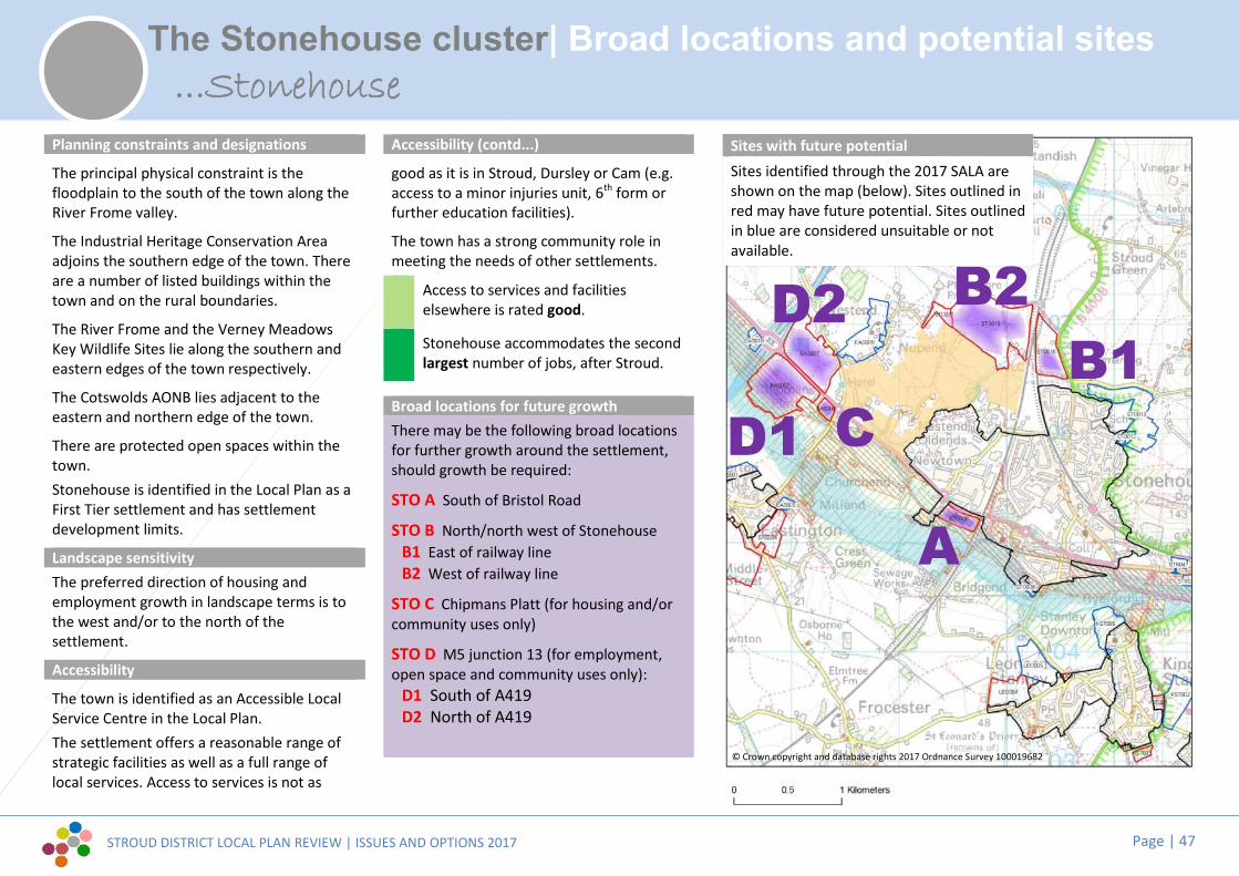
STROUD DISTRICT LOCAL PLAN REVIEW | ISSUES AND OPTIONS 2017 Page | 47
The Stonehouse cluster| Broad locations and potential sites
Planning constraints and designations
The principal physical constraint is thefloodplain to the south of the town along theRiver Frome valley.
The Industrial Heritage Conservation Areaadjoins the southern edge of the town. Thereare a number of listed buildings within thetown and on the rural boundaries.
The River Frome and the Verney MeadowsKey Wildlife Sites lie along the southern andeastern edges of the town respectively.
The Cotswolds AONB lies adjacent to theeastern and northern edge of the town.
There are protected open spaces within thetown.Stonehouse is identified in the Local Plan as aFirst Tier settlement and has settlementdevelopment limits.
Landscape sensitivityThe preferred direction of housing andemployment growth in landscape terms is tothe west and/or to the north of thesettlement.
Accessibility
The town is identified as an Accessible LocalService Centre in the Local Plan.The settlement offers a reasonable range ofstrategic facilities as well as a full range oflocal services. Access to services is not as
Accessibility (contd...)
good as it is in Stroud, Dursley or Cam (e.g.access to a minor injuries unit, 6th form orfurther education facilities).
The town has a strong community role inmeeting the needs of other settlements.
Access to services and facilitieselsewhere is rated good.
Stonehouse accommodates the secondlargest number of jobs, after Stroud.
Broad locations for future growthThere may be the following broad locationsfor further growth around the settlement,should growth be required:
STO A South of Bristol Road
STO B North/north west of StonehouseB1 East of railway lineB2 West of railway line
STO C Chipmans Platt (for housing and/orcommunity uses only)
STO D M5 junction 13 (for employment,open space and community uses only):
D1 South of A419D2 North of A419
Sites with future potentialSites identified through the 2017 SALA areshown on the map (below). Sites outlined inred may have future potential. Sites outlinedin blue are considered unsuitable or notavailable.
...Stonehouse
A
B2B1?CD1
D2
© Crown copyright and database rights 2017 Ordnance Survey 100019682

STROUD DISTRICT LOCAL PLAN REVIEW | ISSUES AND OPTIONS 2017 Page | 48
Cam & Dursley| Broad locations and potential sites
Planning constraints and designations
Physical constraints include the floodplainthat runs along the River Cam, together withthe topography of the valley sides to the east,and the Cotswold escarpment to thesoutheast and southwest.
There are a number of listed buildings,primarily within Upper and Lower Cam.
Westfield and Bownace Woods and Cam Peakand Longdown Key Wildlife Sites lie to thesouthwest and southeast of the townrespectively.
The Cotswolds AONB adjoins the southernedge of the settlement and lies to thesoutheast.
There are protected open spaces within thesettlement and to the northwest.The town is identified in the Local Plan as aFirst Tier settlement and has settlementdevelopment limits.
Landscape sensitivity
The preferred direction for housing growth inlandscape terms is to the north/north eastand east of the settlement.The preferred direction for employmentgrowth in landscape terms is to thenorth/northeast.
AccessibilityCam is identified as an Accessible LocalService Centre in the Local Plan.
The settlement has a very strong local retailrole. The main line rail station is the onlystrategic facility but there is very goodaccessibility to most key services andfacilities, within the town and elsewhere.
Access to services and facilitieselsewhere is rated very good.
Cam accommodates a large number ofjobs.
Broad locations for future growthThere may be the following broad locationsfor further growth around the settlement,should growth be required:CAM A South west of Manor Close (forhousing and/or community uses only)CAM B West of DraycottCAM C North of Box RoadCAM D South of Draycott FarmCAM E East of River Cam (for housingand/or community uses only)
Sites with future potentialSites identified through the 2017 SALA areshown on the map (right). Sites outlined inred may have future potential. Sites outlinedin blue are considered unsuitable or notavailable.
...Cam
CB
AE
D
© Crown copyright and database rights 2017 Ordnance Survey 100019682

STROUD DISTRICT LOCAL PLAN REVIEW | ISSUES AND OPTIONS 2017 Page | 49
Cam & Dursley| Broad locations and potential sites
Planning constraints and designations
There are no significant physical constraints.
There are listed buildings within the north ofthe settlement, clustered around Grade II StBartholomew’s Church. There are listedbuildings at Betworthy Farm and Field Farm,immediately south of the settlement edge.
The recreation ground, north of The Street,and the open space off The Close (in theBetworthy Estate) are both protected outdoorplay spaces.
The village is identified in the Local Plan as aThird Tier settlement and has settlementdevelopment limits.
Landscape sensitivity
The preferred direction of housing growth inlandscape terms is to the south.
There is no identified preferred direction ofemployment growth in landscape terms.
Accessibility
The settlement is identified as an AccessibleSettlement with Limited Facilities in theLocal Plan.
Coaley has a basic level of local retailprovision but a good range of localcommunity services and facilities.
Access to services and facilitieselsewhere is rated very poor.
Coaley accommodates one of thesmallest numbers of jobs of any Tier 1-3settlement.
Broad locations for future growthThere may be the following broad locationsfor further growth around the settlement,should growth be required:
COA A Land between Betworthy Farm andThe Close (for housing and/or communityuses only)
Sites with future potentialSites identified through the 2017 SALA areshown on the map (right). Sites outlined inred may have future potential. Sites outlinedin blue are considered unsuitable or notavailable.
...Coaley
A
© Crown copyright and database rights 2017 Ordnance Survey 100019682

STROUD DISTRICT LOCAL PLAN REVIEW | ISSUES AND OPTIONS 2017 Page | 50
Cam & Dursley| Broad locations and potential sites
Planning constraints and designations
Physical constraints include the floodplainthat runs along the River Ewelme, thetopography of the valley sides to the east, andthe Cotswold escarpment to the south andsouthwest.
Dursley Conservation Area lies at the centreof the town with Woodmancote ConservationArea to the south. There are a number oflisted buildings within the built up area and tothe east.
Hermitage Wood, Gravelpits Wood andDursley Woods Key Wildlife Sites follow theCotswold escarpment to the south west andsouth.
The Cotswolds AONB encloses the town tothe west and south.
There are protected open spaces within thesettlement.
The town is identified in the Local Plan as aFirst Tier settlement and has settlementdevelopment limits.
Landscape sensitivity
The preferred direction for housing growth inlandscape terms is to the southeast.
There is no identified preferred direction ofemployment growth in landscape terms.
Accessibility
The town is identified as an Accessible LocalService Centre in the Local Plan.
The town performs a strategic role, offeringan extensive range of services and facilities.There is very good accessibility to most keyservices and facilities.
Access to services and facilitieselsewhere is rated very good.
Dursley accommodates a very largenumber of jobs.
Broad locations for future growthThere may be the following broad locationsfor further growth around the settlement,should growth be required:
DUR A North of Ganzell Lane (for housingand/or community uses only)
Sites with future potentialSites identified through the 2017 SALA areshown on the map (right). Sites outlined inred may have future potential. Sites outlinedin blue are considered unsuitable or notavailable.
...Dursley
A
© Crown copyright and database rights 2017 Ordnance Survey 100019682

STROUD DISTRICT LOCAL PLAN REVIEW | ISSUES AND OPTIONS 2017 Page | 51
Cam & Dursley| Broad locations and potential sites
Planning constraints and designations
Physical constraints include the floodplainalong the River Ewelme and the topographyof the Cotswold escarpment to the north andwest.
Uley Conservation Area covers most of thevillage. There are a number of listed buildingswithin the village and beyond to the west andsouth. Uley Bury to the north of the village isa scheduled ancient monument.
Uley Bury is also a Key Wildlife Site to thenorth of the village. There are TPOs on thewestern and eastern edges of the village.
The Cotswolds AONB designation covers all ofthe village and surrounding land.
There are three protected outdoor play spaceto the west, east and south of the village.The village is identified in the Local Plan as aThird Tier settlement and has settlementdevelopment limits.
Landscape sensitivityThe landscape parcels around the settlementare all considered to be of high sensitivity toboth housing and employment uses and donot offer any opportunity for housing oremployment allocation, in terms of landscapeand visual factors.
Accessibility
The settlement is identified as an AccessibleSettlement with Limited Facilities in theLocal Plan.
There is a basic level of local retail provisionbut a good range of local services andfacilities.
Access to services and facilitieselsewhere is rated good.
Uley accommodates a small number ofjobs .
Broad locations for future growthThere are no identified locations for growthat Uley.
Limited infill development within settlementdevelopment limits and other developmentappropriate to the settlement’s rurallocation is expected to continue.
Sites with future potentialNo SALA sites were promoted at Uley.
...Uley
© Crown copyright and database rights 2017 Ordnance Survey 100019682
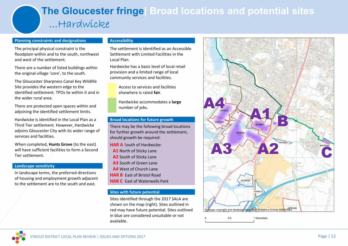
STROUD DISTRICT LOCAL PLAN REVIEW | ISSUES AND OPTIONS 2017 Page | 52
The Gloucester fringe| Broad locations and potential sites
Planning constraints and designations
The principal physical constraint is thefloodplain within and to the south, northwestand west of the settlement.
There are a number of listed buildings withinthe original village ‘core’, to the south.
The Gloucester Sharpness Canal Key WildlifeSite provides the western edge to theidentified settlement. TPOs lie within it and inthe wider rural area.
There are protected open spaces within andadjoining the identified settlement limits.
Hardwicke is identified in the Local Plan as aThird Tier settlement. However, Hardwickeadjoins Gloucester City with its wider range ofservices and facilities.
When completed, Hunts Grove (to the east)will have sufficient facilities to form a SecondTier settlement.
Landscape sensitivityIn landscape terms, the preferred directionsof housing and employment growth adjacentto the settlement are to the south and east.
Accessibility
The settlement is identified as an AccessibleSettlement with Limited Facilities in theLocal Plan.Hardwicke has a basic level of local retailprovision and a limited range of localcommunity services and facilities.
Access to services and facilitieselsewhere is rated fair.
Hardwicke accommodates a largenumber of jobs.
Broad locations for future growthThere may be the following broad locationsfor further growth around the settlement,should growth be required:HAR A South of Hardwicke:
A1 North of Sticky LaneA2 South of Sticky LaneA3 South of Green LaneA4 West of Church Lane
HAR B East of Bristol RoadHAR C East of Waterwells Park
Sites with future potentialSites identified through the 2017 SALA areshown on the map (right). Sites outlined inred may have future potential. Sites outlinedin blue are considered unsuitable or notavailable.
...Hardwicke
A1
A2?
A4
A3
B
C
© Crown copyright and database rights 2017 Ordnance Survey 100019682

STROUD DISTRICT LOCAL PLAN REVIEW | ISSUES AND OPTIONS 2017 Page | 53
The Gloucester fringe| Broad locations and potential sites
Planning constraints and designations
The principal physical constraints are thefloodplain to the south west and north east ofthe settlement and the proximity to the M5 tothe west.
There are a few listed buildings within thevillage centre. A notable cluster exists atNuthill around Bowden Hall on the easterneastern edge of the village.
To the east the Cotswold Beechwoods SAC. Asignificant group of TPO’s exist at Nuthill andon southern development limits. There is aSSSI at Hucclecote Meadows to the north.
The Cotswolds AONB adjoins the settlementto the south, and is adjacent to the east.
There are 3 protected open spaces within thevillage and on the settlement edge.
The village is identified in the Local Plan as aThird Tier settlement and has settlementdevelopment limits.
Landscape sensitivityThe preferred direction for housing growth inlandscape terms is to the southeast. There isalso potential west of Upton Lane in anenclosed field, away from the AONB.
There is no identified preferred direction ofemployment growth in landscape terms.
Accessibility
The settlement is identified as an AccessibleSettlement with Limited Facilities in theLocal Plan. Upton has a basic level of localretail provision, but a good range of localcommunity services and facilities.
Access to services and facilitieselsewhere is rated fair.
Upton St Leonards accommodates amedium number of jobs.
Broad locations for future growthThere may be the following broad locationsfor further growth around the settlement,should growth be required:
UPT A South of Upton St Leonards:
A1 East of The Stanley (for housing and/orcommunity uses only)A2 West of The Stanley, off Perry Orchard(for housing and/or community uses only)
Sites with future potentialSites identified through the 2017 SALA areshown on the map (right). Sites outlined inred may have future potential. Sites outlinedin blue are considered unsuitable or notavailable.
...Upton St Leonards
A2A1
© Crown copyright and database rights 2017 Ordnance Survey 100019682

STROUD DISTRICT LOCAL PLAN REVIEW | ISSUES AND OPTIONS 2017 Page | 54
The Berkeley cluster| Broad locations and potential sites
Planning constraints and designations
The principal physical constraint is thefloodplain to the south west and east of thesettlement.
The Conservation Area covers the towncentre and south eastern part of the town.There are a number of listed buildings withinthe town centre and on the south easternedge of the town.
The Berkeley Heath Key Wildlife Site liesbeyond the village to the north east.
There are protected open spaces within thesettlement.The town is identified in the Local Plan as aSecond Tier settlement and has settlementdevelopment limits.
Landscape sensitivity
The preferred direction of housing growth inlandscape terms is to the north west and westof the settlement.Landscape sensitivity suggests that there maybe a very limited opportunity for small scaleemployment growth to the north of the town,south of the Station Road employment area.
Accessibility
The settlement is identified as a LocalService Centre in the Local Plan.
The town has a very limited strategic rolebut it offers an excellent level of localservices.
Access to services and facilitieselsewhere is rated poor.
Berkeley accommodates a largenumber of jobs.
Broad locations for future growthThere may be the following broad locationsfor further growth around the settlement,should growth be required:
BER A Fitzhardinge Way (for housing and/orcommunity uses only)
BER B Northwest of Berkeley (for housingand/or community uses only)BER C Station Road
Sites with future potentialSites identified through the 2017 SALA areshown on the map (right). Sites outlined inred may have future potential. Sites outlinedin blue are considered unsuitable or notavailable.
...Berkeley
CBA
© Crown copyright and database rights 2017 Ordnance Survey 100019682
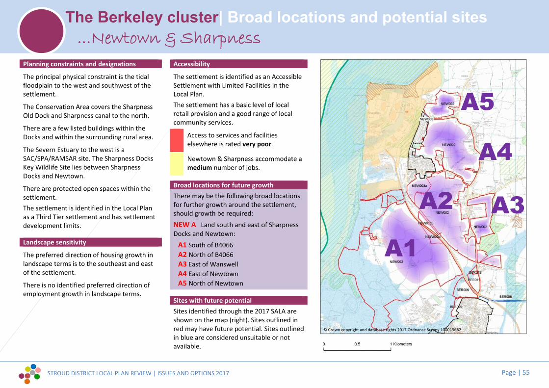
STROUD DISTRICT LOCAL PLAN REVIEW | ISSUES AND OPTIONS 2017 Page | 55
The Berkeley cluster| Broad locations and potential sites
Planning constraints and designations
The principal physical constraint is the tidalfloodplain to the west and southwest of thesettlement.
The Conservation Area covers the SharpnessOld Dock and Sharpness canal to the north.
There are a few listed buildings within theDocks and within the surrounding rural area.
The Severn Estuary to the west is aSAC/SPA/RAMSAR site. The Sharpness DocksKey Wildlife Site lies between SharpnessDocks and Newtown.
There are protected open spaces within thesettlement.The settlement is identified in the Local Planas a Third Tier settlement and has settlementdevelopment limits.
Landscape sensitivity
The preferred direction of housing growth inlandscape terms is to the southeast and eastof the settlement.
There is no identified preferred direction ofemployment growth in landscape terms.
Accessibility
The settlement is identified as an AccessibleSettlement with Limited Facilities in theLocal Plan.The settlement has a basic level of localretail provision and a good range of localcommunity services.
Access to services and facilitieselsewhere is rated very poor.
Newtown & Sharpness accommodate amedium number of jobs.
Broad locations for future growthThere may be the following broad locationsfor further growth around the settlement,should growth be required:NEW A Land south and east of SharpnessDocks and Newtown:
A1 South of B4066A2 North of B4066A3 East of WanswellA4 East of NewtownA5 North of Newtown
Sites with future potentialSites identified through the 2017 SALA areshown on the map (right). Sites outlined inred may have future potential. Sites outlinedin blue are considered unsuitable or notavailable.
...Newtown & Sharpness
A1
A2
A4
A5
A3
© Crown copyright and database rights 2017 Ordnance Survey 100019682

STROUD DISTRICT LOCAL PLAN REVIEW | ISSUES AND OPTIONS 2017 Page | 56
The Berkeley cluster| Broad locations and potential sites
Planning constraints and designations
The principal physical constraint is the Severnfloodplain, which lies to the north of thevillage and wraps around to the east and west(at approximately 0.4km – 1km distance).
The Severn Estuary (Ramsar, SPA, SAC) liesapproximately 1.5km north of the settlement.
There are several listed buildings within thevillage, most clustered around the Church.There is also a Scheduled moated site withinthe settlement, on its eastern edge.
There is protected outdoor play spaceadjoining the southwest settlement edge.
The village is identified in the Local Plan as aThird Tier settlement and has settlementdevelopment limits.
Landscape sensitivity
The preferred direction of housing growth inlandscape terms is to the southwest.
Landscape sensitivity indicates that there maybe only some very limited opportunity foremployment growth to the south, closest tothe A38.
Accessibility
The settlement is identified as an AccessibleSettlement with Limited Facilities in theLocal Plan.
Slimbridge has no significant retail role, butprovides a good range of local communityservices and facilities.
Access to services and facilitieselsewhere is rated poor.
Slimbridge accommodates a mediumnumber of jobs.
Broad locations for future growthThere may be the following broad locationsfor further growth around the settlement,should growth be required:
SLI A Rear of Tyning Crescent / south ofMoorend Lane (for housing and/orcommunity uses only)
Sites with future potentialSites identified through the 2017 SALA areshown on the map (right). Sites outlined inblue are considered unsuitable or notavailable.
...Slimbridge
A
© Crown copyright and database rights 2017 Ordnance Survey 100019682

STROUD DISTRICT LOCAL PLAN REVIEW | ISSUES AND OPTIONS 2017 Page | 57
The Severn Vale| Broad locations and potential sites
Planning constraints and designations
The principal physical constraints are the tidalfloodplain to the west of the settlement andthe floodplain to the north and east of thevillage along the River Frome.
The Frampton Conservation Area covers thecentre of the village. The Industrial HeritageConservation Area lies to the north and eastof the settlement. There are numerous listedbuildings within both conservation areas.
The Gloucester and Sharpness Canal KeyWildlife Site follows the canal to the west ofthe settlement and links to the River FromeKey Wildlife Site to the north and east of thevillage.
There are protected open spaces within andto the north west of the village.
The village is identified in the Local Plan as aSecond Tier settlement and has settlementdevelopment limits.
Landscape sensitivity
The preferred direction of housing growth inlandscape terms is to the northeast. Theremay be some small opportunities to thesoutheast.
The preferred direction of employmentgrowth in landscape terms is to the northeast.
Accessibility
The settlement is identified as a LocalService Centre in the Local Plan.The village has a very limited strategic role,but it offers a good level of local servicesand facilities. The settlement has only aminimal retail role.
Access to services and facilitieselsewhere is rated very poor.
Frampton on Severn accommodates alarge number of jobs.
Broad locations for future growthThere may be the following broad locationsfor further growth around the settlement,should growth be required:
FRA A South of Church Lane (foremployment only)
FRA B Northwest of Whitminster Lane (forhousing and community uses only)
FRA C North of Perry Way/A38 junction(for employment only)
Sites with future potentialSites identified through the 2017 SALA areshown on the map (right). Sites outlined inred may have future potential. Sites outlinedin blue are considered unsuitable or notavailable.
...Frampton on Severn
AB
C
© Crown copyright and database rights 2017 Ordnance Survey 100019682

STROUD DISTRICT LOCAL PLAN REVIEW | ISSUES AND OPTIONS 2017 Page | 58
The Severn Vale| Broad locations and potential sites
Planning constraints and designations
There are no significant physical constraints.
There are a number of listed buildings withinand to the north and south east of the village.
The River Frome Key Wildlife Site abuts thevillage to the south west.
There are protected open spaces within andon the western edge of the settlement.
The village is identified in the Local Plan as aThird Tier settlement and has settlementdevelopment limits.
Landscape sensitivityThe preferred directions of housing growth inlandscape terms are to the northeast andnorthwest.
There is no identified preferred direction ofemployment growth in landscape terms.
Accessibility
The settlement is identified as an AccessibleSettlement with Limited Facilities in the LocalPlan.There is a good, diverse level of local retailprovision and a good range of localcommunity services and facilities.
Accessibility (contd...)
Access to services and facilitieselsewhere is rated fair.
Whitminster accommodates a mediumnumber of jobs.
Broad locations for future growthThere may be the following broad locationsfor further growth around the settlement,should growth be required:
WHI A North of Whitminster Playing Field(for housing and/or community uses only)WHI B South of Whitminster Playing Field(for housing and/or community uses only)WHI C Northwest of Whitminster GardenCentre (for housing and/or community usesonly)WHI D Northeast of Kidnam’s Walk (forhousing and/or community uses only)WHI E East of School Lane (for housingand/or community uses only)
Sites with future potentialSites identified through the 2017 SALA areshown on the map (right). Sites outlined inred may have future potential. Sites outlinedin blue are considered unsuitable or notavailable.
...Whitminster
DE
AB
C
© Crown copyright and database rights 2017 Ordnance Survey 100019682

STROUD DISTRICT LOCAL PLAN REVIEW | ISSUES AND OPTIONS 2017 Page | 59
The Wotton cluster| Broad locations and potential sites
Planning constraints and designations
The principal physical constraint is thefloodplain to the north of the village along theOzleworth Brook.
The Kingswood Conservation Area covers thecentre of the village. There are a number oflisted buildings within and to the north of thevillage.
Ozleworth Brook is identified as a Key WildlifeSite.
There are protected open spaces within andon the western edge of the settlement.
The village is identified in the Local Plan as aThird Tier settlement and has settlementdevelopment limits.
Landscape sensitivityThe preferred directions of housing growth inlandscape terms are to the southwest and tothe southeast.
There is no identified preferred direction ofemployment growth in landscape terms.
Accessibility
The settlement is identified as an AccessibleSettlement with Limited Facilities in theLocal Plan.
There is a basic level of local retail provisionand a limited range of local communityservices and facilities.
Access to services and facilitieselsewhere is rated good.
Kingswood accommodates a largenumber of jobs.
Broad locations for future growthThere may be the following broad locationsfor further growth around the settlement,should growth be required:
KIN A Southeast of Wickwar Road (forhousing and/or community uses only)
KIN B Southeast of Walkmill Lane (forhousing and/or community uses only)
Sites with future potentialSites identified through the 2017 SALA areshown on the map (right). Sites outlined inred may have future potential. Sites outlinedin blue are considered unsuitable or notavailable.
...Kingswood
AB
© Crown copyright and database rights 2017 Ordnance Survey 100019682
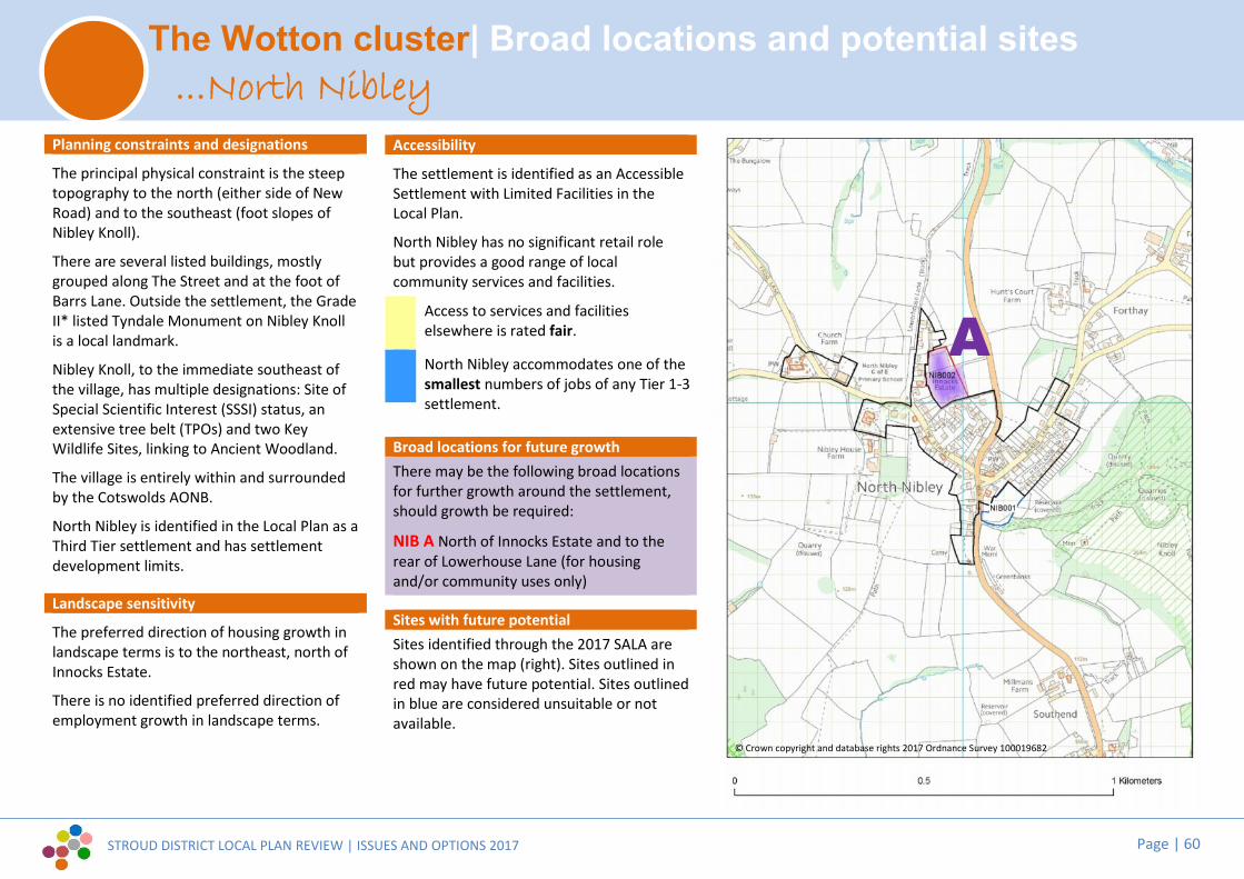
STROUD DISTRICT LOCAL PLAN REVIEW | ISSUES AND OPTIONS 2017 Page | 60
The Wotton cluster| Broad locations and potential sites
Planning constraints and designations
The principal physical constraint is the steeptopography to the north (either side of NewRoad) and to the southeast (foot slopes ofNibley Knoll).
There are several listed buildings, mostlygrouped along The Street and at the foot ofBarrs Lane. Outside the settlement, the GradeII* listed Tyndale Monument on Nibley Knollis a local landmark.
Nibley Knoll, to the immediate southeast ofthe village, has multiple designations: Site ofSpecial Scientific Interest (SSSI) status, anextensive tree belt (TPOs) and two KeyWildlife Sites, linking to Ancient Woodland.
The village is entirely within and surroundedby the Cotswolds AONB.
North Nibley is identified in the Local Plan as aThird Tier settlement and has settlementdevelopment limits.
Landscape sensitivity
The preferred direction of housing growth inlandscape terms is to the northeast, north ofInnocks Estate.
There is no identified preferred direction ofemployment growth in landscape terms.
Accessibility
The settlement is identified as an AccessibleSettlement with Limited Facilities in theLocal Plan.
North Nibley has no significant retail rolebut provides a good range of localcommunity services and facilities.
Access to services and facilitieselsewhere is rated fair.
North Nibley accommodates one of thesmallest numbers of jobs of any Tier 1-3settlement.
Broad locations for future growthThere may be the following broad locationsfor further growth around the settlement,should growth be required:
NIB A North of Innocks Estate and to therear of Lowerhouse Lane (for housingand/or community uses only)
Sites with future potentialSites identified through the 2017 SALA areshown on the map (right). Sites outlined inred may have future potential. Sites outlinedin blue are considered unsuitable or notavailable.
...North Nibley
A
© Crown copyright and database rights 2017 Ordnance Survey 100019682

STROUD DISTRICT LOCAL PLAN REVIEW | ISSUES AND OPTIONS 2017 Page | 61
The Wotton cluster| Broad locations and potential sites
Planning constraints and designations
The principal physical constraint is thefloodplain through the centre of thesettlement.
There are many listed buildings in the towncentre.
There are three Key Wildlife Sites within closeproximity to the settlement: Hentley Wood tothe east; Conygre Wood & Westridge Wood(south) to the north. There is a swathe of landto the north covered by Coombe SSSI &Wotton SSSI.
The settlement is within the Cotswolds AONB.
Wotton-under-Edge is identified in the LocalPlan as a Second Tier settlement and hassettlement development limits.
Landscape sensitivityThe only land parcels with slightly lesssensitivity in landscape terms are to the northeast, north west and south (inner central).
There is no identified preferred direction ofemployment growth in landscape terms.
Accessibility
The town is identified as a Local ServiceCentre in the Local Plan.
Wotton offers a reasonable range of“strategic” facilities, as well as a full range of“local” services and it has a strongcommunity role in meeting the needs ofother settlements.
Access to services and facilitieselsewhere is rated good.
Wotton accommodates a large numberof jobs.
Broad locations for future growthThere may be the following broad locationsfor further growth around the settlement,should growth be required:
WUE A North of Katharine Lady Berkeley’sschool (for community uses only)
Sites with future potentialSites identified through the 2017 SALA areshown on the map (right). Sites outlined inred may have future potential. Sites outlinedin blue are considered unsuitable or notavailable.
...Wotton-under-Edge
A
© Crown copyright and database rights 2017 Ordnance Survey 100019682

STROUD DISTRICT LOCAL PLAN REVIEW | ISSUES AND OPTIONS 2017 Page | 62
The Cotswold cluster| Broad locations and potential sites
Planning constraints and designations
The Bisley Conservation Area covers thesouthern half of the village and extendsfurther to the south, into countryside. Thereare numerous listed buildings, concentratedwithin central and southern parts of thesettlement.
The extensive designated Historic Park andGarden of Lypiatt Park lies 0.5km west of thesettlement.
Bisley is entirely within the Cotswolds AONB.
There is protected outdoor play spaceadjoining the east side of the settlement (offVan De Breen Street).The village is identified in the Local Plan as aThird Tier settlement and has settlementdevelopment limits.
Landscape sensitivity
The preferred direction of housing growth inlandscape terms is to the northeast.Landscape sensitivity indicates that there maybe only a very limited opportunity for smallscale employment use to the north of thevillage (south of existing commercialpremises).
Accessibility
The settlement is identified as an AccessibleSettlement with Limited Facilities in theLocal Plan.
Bisley has no significant retail role, butprovides a good range of local communityservices and facilities.
Access to services and facilitieselsewhere is rated very poor.
Bisley accommodates a small numberof jobs.
Broad locations for future growthThere may be the following broad locationsfor further growth around the settlement,should growth be required:
BIS A Land off Calfway Lane (for housingonly)
BIS B Northwest of the allotments on BisleyRoad (for employment uses only)
Sites with future potential
Sites identified through the 2017 SALA areshown on the map (right). Sites outlined inblue are considered unsuitable or notavailable.
...Bisley
AB
© Crown copyright and database rights 2017 Ordnance Survey 100019682

STROUD DISTRICT LOCAL PLAN REVIEW | ISSUES AND OPTIONS 2017 Page | 63
The Cotswold cluster| Broad locations and potential sites
Planning constraints and designations
Physical constraints include the steeptopography on the valley sides to the southand west and woods to the south.
There are a number of listed buildings withinthe village.
Strawberry Banks Site of Special ScientificInterest (SSSI) lies beyond the western edgeof the village. The Oakridge RecreationGround Key Wildlife Site (KWS) is on theeastern edge of the village. The Valley, Moleyand Great Moley KWS is beyond the village tothe south.
The Cotswolds AONB designation covers all ofthe village and surrounding land.
There is protected outdoor play spaceadjoining the east side of the village.The village is identified in the Local Plan as aThird Tier settlement and has settlementdevelopment limits.
Landscape sensitivity
The preferred direction of housing growth inlandscape terms is to the north of TheCrescent.The landscape parcels around the settlementare all considered to be of high sensitivity toemployment uses and do not offer anyopportunity for employment allocation interms of landscape and visual factors.
Accessibility
The settlement is identified as an AccessibleSettlement with Limited Facilities in theLocal Plan.
There is no significant retail role but thevillage provides a good range of localservices and facilities.
Oakridge Lynch has the worst access toservices and facilities elsewhere.
Oakridge Lynch accommodates one ofthe smallest numbers of jobs of anyTier 1-3 settlement.
Broad locations for future growthThere may be the following broad locationsfor further growth around the settlement,should growth be required:
OAK A North of The Crescent (for housingonly)
Sites with future potentialNo SALA sites were promoted at OakridgeLynch.
...Oakridge Lynch
A
© Crown copyright and database rights 2017 Ordnance Survey 100019682

STROUD DISTRICT LOCAL PLAN REVIEW | ISSUES AND OPTIONS 2017 Page | 64
The Cotswold cluster| Broad locations and potential sites
Planning constraints and designations
The Painswick Stream floodplain is a physicalconstraint to the south and south east of thesettlement.
The Painswick Conservation Area covers mostof the town. Gyde House Conservation Arealies to the north. The town contains asignificant number of listed buildings.
Bulls Cross/Frith Wood Site of SpecialScientific Interest (SSSI) lies beyond the villageto the east. The Cotswolds BeechwoodsSSSI/SAC lies beyond to the north. The towncontains a number of TPOs.
The Cotswolds AONB designation covers all ofthe town and surroundings.
There are protected open spaces with thesettlement.
Painswick is identified in the Local Plan as aThird Tier settlement and has settlementdevelopment limits.
Landscape sensitivity
Landscape sensitivity indicates that there isonly limited potential within or on the northedge of the town for housing growth.
There is no identified preferred direction ofemployment growth in landscape terms.
Accessibility
The settlement is identified as a LocalService Centre in the Local Plan.
Painswick has a quite limited strategic rolebut it offers a good level of local servicesand facilities including to surrounding ruralhamlets and villages.
Access to services and facilitieselsewhere is rated good.
Painswick accommodates a largenumber of jobs.
Broad locations for future growthThere may be the following broad locationsfor further growth around the settlement,should growth be required:
PAI A Washwell Fields (for housing and/orcommunity uses only)
PAI B Stamages (for housing and/orcommunity uses only)
Sites with future potentialSites identified through the 2017 SALA areshown on the map (right). Sites outlined inred may have future potential. Sites outlinedin blue are considered unsuitable or notavailable.
...Painswick
A
B

STROUD DISTRICT LOCAL PLAN REVIEW | ISSUES AND OPTIONS 2017 Page | 65
[1] [2]
[3]

STROUD DISTRICT LOCAL PLAN REVIEW | ISSUES AND OPTIONS 2017 Page | 66
4.1 Background studiesWhilst much of the evidence that underpins thecurrent Local Plan remains relevant and up-to-date, the review of the Local Plan will require theproduction of a number of new studies to identifyfuture needs, to generate options for delivery andto assess potential impacts. At the present time,the following major studies are envisaged, toupdate existing evidence:
Strategic housing market assessment (SHMA),including identifying the objectively assessedneeds for additional housing and affordablehousing needs.
Strategic employment land review
Retail and town centres study
Recreation open space and sports assessment
Energy study
Strategic Flood Risk Assessment (SFRA)
Sustainable transport assessment and audit
Infrastructure Delivery Plan
Viability study
Sustainability appraisal
Habitat regulation assessment
Local communities have produced an extensiverange of documents that will help us to producethe new Local Plan. These include community andparish plans, neighbourhood development plans,design statements, together with backgroundstudies relating to local character, local housingneeds, etc.
Question 4.1
Are there any specific additional local studies ordata that you believe are needed to inform theLocal Plan review? Have you any advice on thescope or content of any of these studies?
Have you prepared, or are you preparing your ownstudies, which may help to inform the Local Plan?

STROUD DISTRICT LOCAL PLAN REVIEW | ISSUES AND OPTIONS 2017 Page | 67
4.2 Image credits and information1. Key Issues
Page 6:[1] Credit: Assael Architecture. This scheme for Ham Mill, Thrupp,
was recently granted Planning Permission. Site section.[2] Credit: Assael Architecture. This scheme for Ham Mill, Thrupp,
was recently granted Planning Permission. Street scene.[3] Credit: Tomas Millar. Architectural practice Millar Howard
Workshop is one of many creative industries, particularly inthe Stroud Valleys, now putting former industrial buildings tonew use as modern work space.
[4] Young people grow up and need homes too.[5] Wotton-Under-Edge, the town centre is a focus for the rural
communities around it.[6] Residents have begun to move into new social rented and
shared-ownership Council homes in Stroud this year. Newhomes have been built to replace old, poorly insulatedconcrete section houses.
[7] New energy efficient homes being built in Leonard Stanley, toreplace older concrete section Council homes.
[8] Littlecombe (Dursley) in 2017.
Page 8:[8] Solar panels on a traditional stone roof.[9] Stonehouse railway station. Is there potential to improve
links to Bristol, South Wales and the Midlands?[10] A new build home in Frampton-on-Severn. Modern oak
framing techniques can be extremely energy efficient, whilstreflecting the architectural heritage of the Gloucester Vale.
[11] Extracts from the Stroud Industrial Heritage ConservationArea character appraisal.
[12] Westmorland Gloucester Services, designed by Glenn HowellsArchitects with AFL Architects, won several Royal Institute ofBritish Architects (RIBA) awards in 2016.
[13] Rural Suds Project: Stroud District Council is pioneering anapproach to natural flood management in the River Fromecatchment.
[14] The Severn Estuary is subject to multiple national andinternational landscape and habitat designations. Impacts onthe estuarine environment of leisure use and developmentneed to be managed and mitigated.
[15] © Nick Turner. Block Party at Stroud Fringe Festival. TheDistrict, and Stroud Town in particular, has a great deal ofartistic and cultural capital.
[16] Neighbourhood Development Plans (NDPs) adopted so far.[17] © Nick Turner.[18] Caring for the Commons ‘til the Cows Come Home. The
Rodborough Common Mitigation Strategy helps to deliverinfrastructure and mitigation measures, funded through acharge levied on some new development within theCommon’s catchment area.
[19] Rush Skate Park, Brimscombe Port.[20] The Cotswold Canals restoration project.
2.1 Local economy and jobsPage 11:[1] Credit: Megan Crouse. Millar Howard Workshop.[2] Sperry Way at Stroudwater Business Park in Stonehouse.
Stonehouse is one of the District’s largest employment hubs.[3] © Renishaw.
Page 13:[4] Credit: SpaceHoppers Co-Working[5] Credit: SpaceHoppers Co-Working[6] Discover Stroud District www.visitthecotswolds.org.uk
2.2 Our town centresPage 14:[1] © Nick Turner. Nailsworth town centre.
Page 16:[2] Stonehouse town centre.[3] © Nick Turner. Wotton-Under-Edge town centre.[4] © Nick Turner. Stroud’s night time economy.[5] © Nick Turner. Stroud’s Farmers Market[6] © Nick Turner. Stroud’s Farmers Market[7] Stroud Valley Artspace (SVA).[8] © Nick Turner. Dursley town centre.
2.3 A need for local housingPage 18:[1] New residents of recently-completed Council homes in Cam.[2] Homes under construction in Cam.
2.4 Local green spaces and community facilitiesPage 19:[1] Horsley Play Project.[2] Horsley Play project.
Page 65[1] © Nick Turner. Saul Junction.[1] © Nick Turner. Bourne Mill, Brimscombe.[1] © Nick Turner. Cotswold Way fingerpost.

[blank page]

Development ServicesStroud District CouncilEbley MillStroudGloucestershireGL5 4UB
The Planning Strategy Team01453 [email protected]
visit www.stroud.gov.uk/localplanreview
Development ServicesStroud District CouncilEbley MillStroudGloucestershireGL5 4UB
The Planning Strategy Team01453 [email protected]
visit www.stroud.gov.uk/localplanreview
Development ServicesStroud District CouncilEbley MillStroudGloucestershireGL5 4UB
The Planning Strategy Team01453 [email protected]
visit www.stroud.gov.uk/localplanreview