Embed Size (px)
Citation preview
Strike-slip faulting and block rotation: a possible triggering mechanism forlava flows in the Alban Hills?
Fabrizio Marra*
Istituto Nazionale di Geofisica e Vulcanologia, Via di Vigna Murata 605, 00143 Rome, Italy
Received 4 October 1999; accepted 30 May 2000
Abstract
It is suggested in this paper that two distinct tectonic triggers, tapping different depths of a magma reservoir, may be the cause of nearlycontemporaneous eruptions of lava flows and ignimbrites in the Alban Hills. The area between the Alban Hills and Rome underwentalternating regional extensional and strike-slip faulting during the Middle Pleistocene. The geometries of the main structural dislocations inQuaternary strata, combined with a statistical analysis of drainage network trends, show a structural pattern that is consistent with local strainpartitioning in transpressive zones at strike-slip fault bends, superimposed on regional extension. Based on this analysis, it is suggested thatlocal clockwise block rotation between parallel N–S strike-slip faults might have generated local crustal decompression, allowing relativelyvolatile-free magma to rise from deep reservoirs beneath the Alban Hills, triggering peripheral fissure lava flows. In contrast, the mainignimbrite eruptions appear to tap shallow, volatile-rich magma reservoirs and are controlled by extensional processes.q 2001 ElsevierScience Ltd. All rights reserved.
1. Introduction
Rome is located on the margin of the Central TyrrhenianSea, at the convergence of a series of major structural linea-ments (Fig. 1). The Latium Volcanoes (Vulsini, Cimini, MontiSabatini and Alban Hills) are aligned along the strike of exten-sional structures which formed at the rear of the Apenninefold-and-thrust belt (Funiciello et al., 1976; Locardi et al.,1977; Funiciello and Parotto, 1978). The continuity of theCentral Apennines is interrupted along the Olevano–Antro-doco line, a N-striking thrust front across which the Umbria-Marche Basin is thrusted eastward over the Latium-AbruzziCarbonate Platform (Parotto and Praturlon, 1975; Salvini andVittori, 1982). A few kilometers west of this line is the SabinaFault, a N10–208 shear zone described by Alfonsi et al.(1991). The southern end of the Sabina Fault had strike-slipactivity from Pliocene through middle–late Pleistocene time,developed through a series of N-striking right-lateral enechelon fault segments (Faccenna and Funiciello, 1993;Faccenna et al., 1994a). N-striking right-lateral strike-slipfaulting has been proposed as the most recent tectonic stylefor the area of Rome, implying a NW-strikings3 (Faccennaand Funiciello 1993; Faccenna et al., 1994a).
In contrast to this scenario, recent seismicity, including a
ML � 3.6 earthquake (June 12, 1995) in the Cecchignolaarea south of Rome (Figs. 1 and 2), is consistent with seis-mic activity associated with the Alban Hills volcano (Amatoet al., 1994; Amato and Chiarabba, 1995), which has apresent-day stress-field characterized by a NE-trendings3
(Montone et al., 1995). The Cecchignola earthquake showedright-lateral oblique slip and occurred at a depth of 11.5 kmon an E–W striking fault located 15 km west of the centralcaldera of the Alban Hills (Basili et al., 1996). It was there-fore interpreted as a tectonic earthquake that re-activated apre-existing strike-slip fault with oblique slip under NE–SW extension (Marra, 1999).
The common northeast orientation of the tension (T) axesof the Cecchignola and Alban Hills earthquakes suggeststhat back-arc extension along the Tyrrhenian margincontrols Roman seismicity (Marra, 1999). Alternatively,tectonic activity responsible for the E–W structures hasbeen proposed to be linked with N-striking right-lateralfaulting that generated localized transpression aroundRome (Marra, 1999). The transpressive feature of the N–Sshear zone associated with the Sabina Fault is due to a majorrestraining bend that occurs in the area of Rome (see Fig.1b). These strike-slip features are superimposed on regionalextension, possibly due to the northeast escape of theNorthern Apennines relative to the Central Apenninesalong the Sabina Fault (Marra, 1999).
The fault geometry that affects the sedimentary and
Journal of Structural Geology 23 (2001) 127–141
0191-8141/01/$ - see front matterq 2001 Elsevier Science Ltd. All rights reserved.PII: S0191-8141(00)00068-7
www.elsevier.nl/locate/jstrugeo
* Corresponding author.E-mail address:[email protected] (F. Marra).

volcanic strata and drainage network around Rome is inves-tigated here and reinterpreted in order to reconstruct the defor-mational history between Rome and the Alban Hills and toevaluate possible relationships between tectonism and volcan-ism. The aim of this work is to understand emplacementmechanisms for nearly contemporaneous lava and pyroclasticeruptions, since these volcanics cannot be explained as thesimple evolution of a common magma source.
2. Geological, volcanological and structural setting
The geology consists of a Plio-Pleistocene marine clay
substrate (Marra et al., 1995) which fills extensional basinsthat formed at the rear of the Apennine fold-and-thrustbelt. Middle Pleistocene age alluvial sediments (Karnerand Renne, 1998; Karner and Marra, 1998, Marra et al.,1998) lie above the substrate and interfinger with volcanicrocks from the Monti Sabatini and Alban Hills. Thick tuffhorizons form most of the outcrops around Rome, exceptwhere they are incised by Holocene cut-and-fill alluvialvalleys of the Tiber and Aniene Rivers and their tributaries(Fig. 1b).
The explosive activity of the Alban Hills started557^ 14 ka and lasted until 353 3 ka (Karner and Renne,1998). It was followed by an effusive period that emplaced
F. Marra / Journal of Structural Geology 23 (2001) 127–141128
Fig. 1. (a) Structural sketch map of Central Italy. (b) Geologic map of the investigated area: the mechanism capable of generating local transpression in the areaof Rome is shown.
several lava flows, and by a late hydromagmatic phase thattook place in more recent time (De Rita et al., 1988, 1995).
Several large pyroclastic flows (ignimbrites) wereemplaced during the explosive phase, whereas only minoreffusive activity is associated with this phase and was inter-preted to occur in the final stages of the eruptive cycles (DeRita et al., 1988). The pyroclastic flows which are importantfor this paper include the Pozzolane Rosse (‘pozzolana’ is aterm used to describe a scoriaceous ash-flow, 455^ 8 ka,Karner and Renne, 1998), and the Pozzolanelle–TufoLionato (353 4 ka, Karner and Renne, 1998). ThePozzolanelle and Tufo Lionato are interpreted as productsof two phases of the same eruption (Villa Senni Eruption,Marra and Rosa, 1995). Volumetrically less significant lavaflows are associated with these ignimbrite eruptions. Marra(1999) has shown that all the outcrops of lava to the south ofRome that were previously attributed to different eruptivecycles of early Alban Hills volcanism are one single lavaflow (hereafter the Vallerano Lava, 4578 ka by Karnerand Renne, 1998), erupted from a local fissure field ratherthan from the central edifice of the Alban Hills. Previously,
different outcrops of this lava (at Selcetta, Acquacetosa,Cecchignola and Vallerano) were interpreted as differentflows (De Rita and Rosa, 1990; De Rita et al., 1995),some supposedly below the Pozzolane Rosse (Selcetta,Acquacetosa and Cecchignola), and at Vallerano abovethe Pozzolane Rosse. However, Marra (1999) shows thatthe Vallerano Lava was erupted just prior to the PozzolaneRosse pyroclastic flow, consistent with its40Ar/39Ar age.Marra (1999) also indicates that at least some of the PozzolaneRosse erupted from a N1408-striking fissure cut through theVallerano Lava. This indicates that the Pozzolane Rossepostdates the Vallerano Lava, thus the eruptive sequenceis from effusive (Vallerano lava) to explosive (PozzolaneRosse), contrary to the more common sequence of pyro-clastic eruption followed by lava emission after de-gassing.
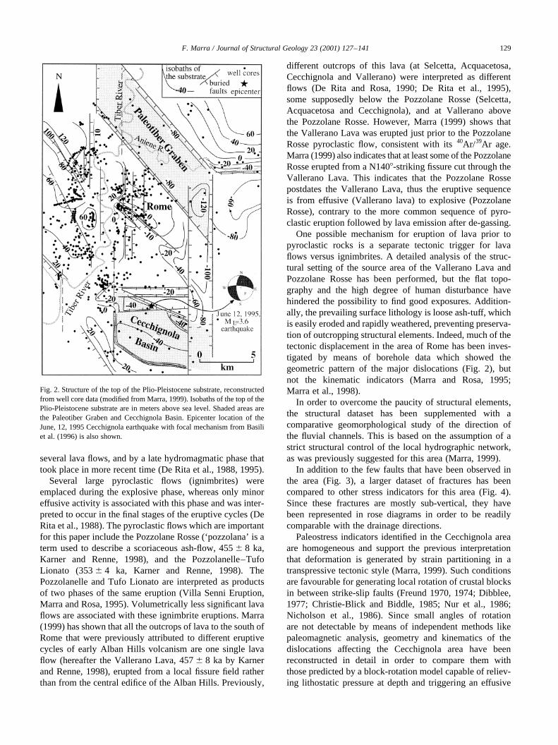
One possible mechanism for eruption of lava prior topyroclastic rocks is a separate tectonic trigger for lavaflows versus ignimbrites. A detailed analysis of the struc-tural setting of the source area of the Vallerano Lava andPozzolane Rosse has been performed, but the flat topo-graphy and the high degree of human disturbance havehindered the possibility to find good exposures. Addition-ally, the prevailing surface lithology is loose ash-tuff, whichis easily eroded and rapidly weathered, preventing preserva-tion of outcropping structural elements. Indeed, much of thetectonic displacement in the area of Rome has been inves-tigated by means of borehole data which showed thegeometric pattern of the major dislocations (Fig. 2), butnot the kinematic indicators (Marra and Rosa, 1995;Marra et al., 1998).
In order to overcome the paucity of structural elements,the structural dataset has been supplemented with acomparative geomorphological study of the direction ofthe fluvial channels. This is based on the assumption of astrict structural control of the local hydrographic network,as was previously suggested for this area (Marra, 1999).
In addition to the few faults that have been observed inthe area (Fig. 3), a larger dataset of fractures has beencompared to other stress indicators for this area (Fig. 4).Since these fractures are mostly sub-vertical, they havebeen represented in rose diagrams in order to be readilycomparable with the drainage directions.
Paleostress indicators identified in the Cecchignola areaare homogeneous and support the previous interpretationthat deformation is generated by strain partitioning in atranspressive tectonic style (Marra, 1999). Such conditionsare favourable for generating local rotation of crustal blocksin between strike-slip faults (Freund 1970, 1974; Dibblee,1977; Christie-Blick and Biddle, 1985; Nur et al., 1986;Nicholson et al., 1986). Since small angles of rotationare not detectable by means of independent methods likepaleomagnetic analysis, geometry and kinematics of thedislocations affecting the Cecchignola area have beenreconstructed in detail in order to compare them withthose predicted by a block-rotation model capable of reliev-ing lithostatic pressure at depth and triggering an effusive
F. Marra / Journal of Structural Geology 23 (2001) 127–141 129
Fig. 2. Structure of the top of the Plio-Pleistocene substrate, reconstructedfrom well core data (modified from Marra, 1999). Isobaths of the top of thePlio-Pleistocene substrate are in meters above sea level. Shaded areas arethe Paleotiber Graben and Cecchignola Basin. Epicenter location of theJune, 12, 1995 Cecchignola earthquake with focal mechanism from Basiliet al. (1996) is also shown.

lava eruption. This mechanism is here attributed to episodicstrike-slip faulting, superimposed on larger scale extension,the latter being responsible for triggering the main ash floweruptions of the Alban Hills.
Well data from previous work (Marra et al., 1998; Marra,1999) have been integrated to identify dislocations affectingthe substrate (Fig. 2) and to compare the attitudes of thesedislocations with trends of the hydrographic network
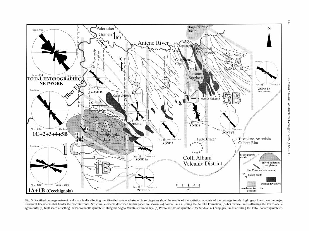
throughout the area, presumed to reflect in part more recenttectonic movements (Fig. 5). The subsurface of Rome isstrongly controlled structurally by N- and NW-strikingfaults, which have formed two principal basins (Fig. 2).The first is the Paleotiber Graben, a,N1408 trending,12× 5 km wide basin, filled with approximately 100 m offluvial-lacustrine sediments. The second is the CecchignolaBasin, a rhomb-shaped depression bordered by N-, and
F. Marra / Journal of Structural Geology 23 (2001) 127–141130
Fig. 3. Field evidence for transpressive and extensional faulting affecting rocks younger than approximately 300 ka. (a) Conjugate strike-slip faults cutting theTufo Lionato ignimbrite at Perna Stream Valley (Fig. 5 spot d for location). A principal fault plane strikes N608 and shows several oblique (pitch� 308) striae(close-up picture); a secondary fault plane strikes N1208 and has striae with a pitch of 358. Oblique, divergent striae with respect to a pure strike-slip theoreticalfaulting are probably linked with uplift and rotation of the faulted blocks. (b) Reverse fault striking N058 and dipping 35E in the Pozzolanelle ignimbrite(Fig. 5, spot b). (c) N3208, 75NE8 normal fault in lacustrine deposits of the Aurelia Formation (Fig. 5 spot a).

,N1208- to N908-striking faults. Agreement between theN1208- and N908-striking faults and the trends of the fluvialchannels inside the Cecchignola Basin was noted by Marra
(1999). Five meters of vertical displacement is seen in thePozzolanelle ignimbrite, generating an E–W fault scarp thatcontrols the course of the Vigna Murata stream (Figs. 4, 5
F. Marra / Journal of Structural Geology 23 (2001) 127–141 131
Fig. 4. Landsat image of the Cecchignola area. Rectilinear trends of the hydrographic network are particularly visible in the southern zone. Rose diagrams withfracture directions collected along the major stream valleys are shown and compared to rose diagram of rectified streambed directions. A conjugate faultsystem observed by Faccenna et al. (1993) near the San Martino Stream north of Rome is also shown for comparison with the small dataset from the PernaStream valley.
F.
Ma
rra/
Jou
rna
lof
Stru
ctura
lGe
olo
gy
23
(20
01
)1
27
–1
41
132
Fig. 5. Rectified drainage network and main faults affecting the Plio-Pleistocene substrate. Rose diagrams show the results of the statistical analysis of the drainage trends. Light gray lines trace the majorstructural lineaments that border the discrete zones. Structural elements described in this paper are shown: (a) normal fault affecting the AureliaFormation, (b–b’) reverse faults offsetting the Pozzolanelleignimbrite, (c) fault scarp offsetting the Pozzolanelle ignimbrite along the Vigna Murata stream valley, (d) Pozzolane Rosse ignimbrite feeder dike, (e) conjugate faults affecting the Tufo Lionato ignimbrite.

spot c, and 6). Moreover, several other tectonic displace-ments occur in correspondence with the stream valleys, asshown in the cross-section of Fig. 6.
The Cecchignola Basin contains the buried ValleranoLava plateau, an,2.25 km3 flow that accumulated in theBasin and subsequently has been dislocated by normal faults(Fig. 4a). The chemical composition of this lava (Trigila etal., 1995) is in the K-foidite field of the total-alkali-silica
(TAS) classification of Le Bas et al. (1986). Directly abovethe Vallerano Lava is the Pozzolane Rosse pyroclastic flow.Scoria clasts of the Pozzolane Rosse are in the Tephrite fieldof the TAS diagram (Trigila et al., 1995), thus have a highersilica content than the Vallerano Lava. Additionally, ageochemical study of phlogopite in the Vallerano Lavaand Pozzolane Rosse, as well as in other volcanic productsfrom the Alban Hills (Gaeta et al., 2000) shows that there is
F. Marra / Journal of Structural Geology 23 (2001) 127–141 133
Fig. 6. (a) N–S cross-section of the Vallerano lava plateau (see line of section in Fig. 5). (b) Feeder dike of the Pozzolane Rosse ignimbrite at Vallerano (seeFig. 5 spot d for location).

a systematic difference between phlogopite compositions inlavas and those in pyroclastic rocks. Gaeta et al. (2000)interpret the composition of groundmass phlogopite in thelavas as evidence of rapid magma ascent from a deep reser-voir. In contrast, they interpret the composition of phlogo-pite in the pyroclastic rocks to be from a more shallowmagma source, consistent with the depth of the magmachamber beneath the Alban Hills, which a tomographicstudy indicates is at a depth of 5–6 km (Amato andChiarabba, 1995). These geochemical differences suggestthat the Vallerano Lava and Pozzolane Rosse may havetapped different magma bodies, or at least different portionsof the same body.
At Vallerano, a lava-pyroclastite transition is seen in thefeeder dike of the Pozzolane Rosse (Fig. 6b). Here, anaggregate of rounded dark gray scoriae with dense coresand vessiculated rinds are at the top of the dike, and gradeoutwards into an ash-flow tuff. These textural features arethe same as those described by Locardi and Mittempergher(1967) who describe ‘foam lavas’ as the rounded scoriablocks that are observed in Vallerano. They interpret foamlavas to be the transition from lava to ‘ignimbrite’, in accor-dance with the observations at Vallerano. Laterally, areddish ash matrix develops away from the mouth of thefeeder dike. A 5-m-thick ‘sill’ of pozzolana horizontallyextends several tens of meters into the Vallerano Lava(Fig. 4b) showing that this dike is the eruptive conduit ofthe Pozzolane Rosse in this area. It is clear that the magmadecompressed upon reaching the surface, forming a fissureash flow. The initial, volatile-rich phase also intruded ahorizontal fracture in the Vallerano lava producing theobserved ‘sill’, whereas the final, de-gassed phase filledthe feeder conduit and spilled out of the eruptive mouthand onto the surface.
Field observations provide evidence for both transpres-sive and extensional faulting in the area of Rome. In parti-cular, a large set of structural elements associated with aprincipal right-lateral N–S fault zone has been documentedin the northern area of Rome (Faccenna and Funiciello,1993; Faccenna et al., 1993, 1994a,b). Local transpressionassociated with this fault zone has been suggested by Marra(1999) on the basis of its regional trend which forms arestraining bend and justifies the presence of severalE–W8- and N120-striking faults in this area as the resultof strain partitioning between the principal N–S faultsegments (Fig. 1b).
Few structural elements with clear kinematic indicatorshave been found in the Cecchignola area. Even though theyfit the proposed model of strain partitioning, they should beconsidered together with the stream channel direction datain order to evaluate a reliable local stress tensor for this area.Several N1008–1208 oblique faults affect the lithified TufoLionato along the Fosso della Perna valley (Figs. 3 and 4).Well defined oblique striae have generally poorly preservedslickensides, the exception being two large fault planesshown in Fig. 3. These two conjugate vertical faults with
oblique striae are at the west border of the CecchignolaBasin in a stream valley that flows E–W (Fig. 5, spot e).This stream channel is fragmented into a series of N908segments, connected by N608–708 and N1208 bends. Thefaults strike N608 and N1208, and both have vertical dip.Pitch of the striae is 308 and 358, respectively; slickensidesindicate left-lateral motion. Strikes and dips of these faultscorrespond to those expected for a conjugate system gener-ated by pure shear under E–W compression, as predicted ina model of strain partitioning by Marra (1999) for this area.Incompatible left-lateral motion on both fault planes isexplained in Fig. 3 as the effect of the extrusion of acompressed block. It is likely that the lack of lithostaticpressure that affects the near surface stress field causedupward displacement of the compressed blocks, whichresulted in an oblique rake for the faults rather than thetheoretical horizontal pitch (Fig. 3a).
Evidence for E–W compression is also 10 km north ofCecchignola, along the two N-striking faults that border theCecchignola Basin (Fig. 5, spot b). A reverse fault strikingN058 and dipping 358E displaces the Pozzolanelle verticallyby 1 m, with no detectable strike component (Fig. 5b).Another N–S reverse fault affects the volcanic rocks inRome, north of the Aniene River (Fig. 5, spot b’).
Extensional faulting also affects rocks younger than thePozzolanelle pyroclastic unit. A dip–slip normal fault,striking N3208 displaces sediment of the Aurelia Formation(Figs. 3c, 5 spot a), the approximate age of which is 300 ka(Karner and Renne, 1998). According to seismic data, thepresence of NW–SE-trending normal faults affectingterrains as young as 300 ka suggests, that NE–SWextension overprinted the trascurrent regime again in recenttime.
3. Geomorphological analysis
Preferential drainage alignments with left steps in fluvialchannels in the Cecchignola Basin (Figs. 4 and 5) are inter-preted as structural control on the present-day hydrographicnetwork (Marra, 1999). A quantitative analysis of drainagetrends in a larger area is made here for a 10-km-wide bandsoutheast of the Tiber and Aniene Rivers. Results from thisanalysis are plotted on rose diagrams and compared with theregional deformation pattern of the northwest half of theAlban Hills (Fig. 5). A common technique that rectifiesdirections of stream beds is applied (e.g. Ciccacci et al.,1987; Buonasorte et al., 1991; Caputo et al., 1993). Theassumption is made that each rectified portion of a fluvialbed may represent the direction of a fault controlling itscourse. While it is possible that rectifying drainage patternscan introduce directionality that is unrelated to structuralcontrol, it still does indicate preferential directions of riverflow. In the case that these preferential directions of riverflow are statistically significant and are different from thoseexpected from non-structural controls (e.g. topographic and
F. Marra / Journal of Structural Geology 23 (2001) 127–141134

geographic trends), they are interpreted to be diagnostic ofthe structural setting.
In rose diagrams, stream channel directions are plottedaccording to length and subdivided into three groups as afunction of their length, independent of hydrographic order.The highest hydrographic orders corresponding to theshortest fluvial channels have not been considered for thiswork, in order to avoid the introduction of bias into the dataset. Total trends for the 10-km-wide band are compared tolocal trends within discrete zones, corresponding to theareas bounded by the main structural lineaments (Figs. 2and 5). Three large zones (1, 3 and 5) are divided by twoN–S fault zones (zones 2 and 4), the latter of which containa series of structural basins. In zone 2, the top of the Plio-cene substrate and the base of the volcanics are significantlylowered (Marra and Rosa, 1995). In zone 4 are the recenttectonic basins of Bagni Albule, Pantano di Granaraccio andPantano Borghese, and the Castiglione and Faete volcanic
craters. Two unique zones (1A and 5A) are noted also fortheir common geological and structural features.
The analysis of the total area shows that the averagedirections of the stream channels are dominated by NW–SE alignments (Fig. 5, upper left corner). This is in goodagreement with a previous statistical analysis for the wholehydrographic network around the Alban Hills (Caputo et al.,1995), which showed two preferential northwest and northtrends, attributed by those authors to regional structuralcontrol. However, the N–S trend in Caputo et al. wasbased chiefly on analysis of the highest hydrographic orders,which have not been included in this study.
4. Discussion of geomorphological data
The hydrographic network has developed by cuttingthrough the Pozzolanelle ignimbrite, the top of whichforms a flat surface that now constitutes the ‘CampagnaRomana’. Without structural control, a radial drainagetrend would be expected leading away from the AlbanHills, but the plot in Fig. 5 shows a maximum concentrationof fluvial channel directions oriented N1458. This directionmatches the strike of extension-induced faults and fracturesand agrees with the present day stress field determined fromfocal mechanisms in the Alban Hills region (Montone et al.,1995).
A radial drainage trend is detectable in the western area,where stream bed rotation from E–W to NW–SE occurs(Fig. 5, zones 1A, B, 2, 3). In the eastern area, the super-position of a preferential NW–SE direction on the trends ofthe hydrographic network is recognizable (Fig. 5 zones 2, 3,4, 5B). Finally, N–S trending fluvial beds are parallel to N-striking fault zones in zones 2 and 4.
Drainage in the Cecchignola Basin is characterized bya unique concentration of the trends. Prevalent,N1208and N908 and minor ,N608 lineaments characterizethe drainage network between the two principal N-striking border faults (Fig. 5 zones 1A, B; Fig. 7b). Inparticular, ,N1208 and a secondary conjugate,N608,together with a N908 set of lineaments, are present to thesouth (Fig. 5 zone 1B; Fig. 7c). A similar pattern of major,N1258 and relatively minor N908 trends is present insidethe Cecchignola Basin (Fig. 5 zone 1A; Fig. 7c), while a,N708 trend is very poorly defined. While N1458-strikinglineaments are predominant immediately outside the twoborder faults (Fig. 5 zone 1C), they are nearly missing inzones 1A and 1B.
While a unimodal distribution of the trends would havebeen a strong indication of a control by the first order topo-graphic gradient in the investigated area, the observedconcentration around three different maxima in the twosubzones of the Cecchignola Basin (Fig. 8) is not consistentwith topographic control.
In agreement with a previous study (Marra, 1999), thepresence of 1208 and N908 and lack of N1458 drainage
F. Marra / Journal of Structural Geology 23 (2001) 127–141 135
Fig. 7. (a) Transpression model to generate localized pure-shear betweenplanes of simple shear (after Jones and Tanner, 1995). (b) Conjugate set ofvertical transcurrent faults, reverse faults and fractures expected inside thepure shear zone (after Sylvester, 1988) and induced block-rotation (afterNur et al., 1986). (c) Clockwise rotation of rigid blocks inside theCecchignola Basin interpreted from fluvial channel directions (Fig. 5zone 1A). (d) Decompression model (after Nicholson et al., 1986;Christie-Blick and Biddle, 1985) at the corner of the rotated blocks in theCecchignola Basin.

trends in the Cecchignola area is here interpreted to berelated to unique structural control of this area. TheseN1208 and N908 drainage trends are found in discretezones around Rome. E–W trends are still evident in zone1A, where the existence of a fault controlling the E–Wcourse of the Vigna Murata stream valley has been shown(Marra, 1999). Four E–W-trending faults have been identi-fied from well data, which also allow us to recognize a,N1208-striking fault bordering the south of theCecchignola Basin. Additionally, several,N1208-orientedfluvial channels inside zones 1A and 1B have left stepswhich constitute the N60–708 secondary concentration onthe rose diagrams (Figs. 4 and 5). A very similar set ofconjugate strike-slip faults is found in the northen area ofRome, near the N–S-striking San Martino stream valley(Faccenna et al., 1993), and it is here compared to thesmaller dataset from the Cecchignola area (Fig. 4).
Fig. 5 shows another zone (5A) north of the Alban Hillswhich has a structural setting similar to the Cecchignolaarea. Principal,N1208 and secondary,N908 bends ofthe left tributaries of the Aniene River are recognizablenear San Vittorino. This area mimics the stratigraphic, struc-tural, volcanological and seismological characteristics ofthe Cecchignola (Marra, 1999), and thus has been treatedseparately in the statistical analysis. The only other outcropof lava that occurs in the same stratigraphic position and hasprobably the same age as the Vallerano Lava lies here at SanVittorino (Fornaseri et al., 1963; see Fig. 5).
5. Block-rotation model
The N908-, N1208- and N608-striking faults controllingfluvial valleys and dislocating the volcanics suggests acommon tectonic origin for these trends. These fault orien-tations have been predicted by a theoretical model for strainpartitioning in transpressive zones (Marra, 1999). Trans-pression around Rome is caused by a left step in the right-lateral strike-slip Sabina Fault (Marra, 1999). A mechanismcapable of generating localized areas of pure shear betweenparallel strike-slip faults in transpressive zones wasproposed by Jones and Tanner (1995) (Fig. 7a). In thismodel, when a north strike for parallel strike-slip faults isconsidered, approximately N608 and N1208 conjugatestrike-slip faults are expected, together with E–W tensilefractures (Fig. 7b).
It is here proposed that after formation, the conjugate setsof faults rotated in response to transpression (Fig. 7b), amechanism that has been suggested for other areas (Nur etal., 1986; Freund 1970, 1974; Dibblee, 1977; Nicholson etal., 1986). Rotation of rigid blocks around a vertical axis canresult in the discharge of lithostatic pressure at the cornersof the blocks (Christie-Blick and Biddle, 1985; see Fig. 7d).In a volcanic region, the corners of such blocks may belikely sites for decompression melting, and the faultscould provide preferential magma conduits. De Rita et al.(1995) suggested a similar mechanism for eruptions of themajor pyroclastic flows from the Alban Hills central edifice.
An ,58 clockwise rotation in the Cecchignola Basin isinterpreted in Fig. 7. The lineaments inside the rhomb-shaped zone, corresponding to the buried lava plateau, strike,N1258 and,N708 (zone 1A, shaded in Fig. 7c), whereasto the south they strike close to N1208 and N608 (Fig. 5 zone1B; Fig. 7c). Further statistic treatment of the trends of thefluvial channels in zones A and B has been performed inorder to better define a possible systematic rotation. Thecomplete hydrographic network including the channels ofthe highest orders has been subdvided into rectifiedsegments. Each of the resulting directions has beenweighted as a function of the segment length. The resultingdistribution of stream channel directions is shown in histo-grams in Fig. 8.
The conjugate set of lineaments predicted in the theore-tical model is still well reproduced in zone B, where it ispossible to recognise the three concentrations around 608,908, and 1208. A less defined distribution is obtained forzone A, where a strong maximum concentration peaks at1278 and a secondary peak is at 1208. Only two other peakscan be distinguished in zone A, corresponding to 908 and1358. With the exception of the lack of any relevant concen-tration at 60–708, the distribution of stream directions inzone A mimics that of zone B as it shows a relative peakat 908 and a great dispersion between this value and a maxi-mum at 1278. This is something expected in the case weassume that most lineaments in the zone A underwent rota-tion through time. In particular, the second maximum at
F. Marra / Journal of Structural Geology 23 (2001) 127–141136
Fig. 8. Histograms showing frequency distributions of stream channeldirections inside the Cecchignola zones A and B.
1208 in zone A is possibly interpretable as the indication ofthe existence of some unrotated (or newly generated)lineaments with that strike. It is here proposed that a maxi-mum 78 clockwise rotation of zone A with respect to zone Bin the Cecchignola area occurred as a consequence oftranspressive tectonics. This 78 of rotation within theCecchignola Basin should be considered the cumulativeeffect of several 100 kyr of displacement on the N–S borderfaults.
Even though this interpretation based on geomorphicobservations is not unique and is far from being definitivelyproved, it is a supporting indication of local block rotationwhen considered in the light of the reconstructed geometryof dislocations and the recognised transpressive tectonicstyle. The sense of rotation, interpreted as unrelated to thehydrographic trend, is indicative of a right-lateral sense ofshear on the N-striking faults, which is the same as observedat the Sabina to Alban Hills shear zone (Alfonsi et al., 1991;Faccenna and Funiciello 1993). Slickensides on the striatedfault planes in Fig. 5a indicate left-lateral motion on theplane that strikes N608 and on the N1208 fault plane aswell. This is in agreement with the expected sense of motionfor the N1208 faults to accommodate clockwise block rota-tion by dextral N–S strike-slip faulting (Fig. 7d).
Different from the other faults, the E–W lineamentsappear to be generated more recently as tensile fracturesinduced by E–W compression inside the pure-shear zone,when the rotation of the faults among the blocks wascomplete. These E–W lineaments, as well as the,N1208ones, represent possible discontinuities which may act asoblique to normal faults under NE–SW extension, thusthey likely underwent a re-activation in recent time asproposed in order to explain the focal mechanism for theJune 12, 1995 Cecchignola earthquake (Marra, 1999).
Based on these data, it is here suggested that the eruptionand emplacement of the Vallerano Lava could be the resultof local block rotation. This mechanism would cause tensilefractures to extend through the upper crust, reaching to thedecollement level of the rotating blocks. It has been shownthat volcanism and geothermal potential could be associatedwith local extension induced by strike-slip faulting (Weaverand Hill, 1978/79; Bacon et al., 1980; Aydin et al., 1990).The Vallerano Lava is within the zone of,58 clockwiserotation of fluvial beds (Fig. 7c), suggesting a direct linkagebetween block-rotation and lava eruption.
The horizontal displacement necessary to induce a rigidblock rotation of 58 (considered as an average realistic value)in the Cecchignola Basin is estimated as follows (Fig. 7d).Assumingb� 58, blocks dimension width (w)� 2.5 km anda� 608 (from originally N1208-striking faults among therotating blocks), the simplified model in Fig. 7d allows usto estimate a horizontal displacement (d)� 0.164 km. Thearea (A) of potential decompression is given by:A � (L0 1 d)H/2 where H�wsinb and L0�w/(cos90-a).The induced decompression is given by: AZr where Z isthe decollement depth andr the rock density.
6. Discussion
Evidence for alternating extensional and strike-slip fault-ing are found throughout the area. The NW–SE strike of thefeeder dike of the Pozzolane Rosse indicates that NE–SWextensional faulting probably triggered this ash-flow erup-tion. It is therefore questionable whether another type ofdisplacement, namely strike-slip faulting, triggered theeruption of the lava flow.
A possible early utilisation of the N–S discontinuity underthe NE–SW extensional regime seems unlikely, because nosubstantial difference in the eruptive mechanism and itsproducts would be expected in this case. Moreover, the N–S discontinuities are regional faults that are less favourablyoriented with respect to the NW–SE ones in order to act asbetter pathways for the magma during NE–SW extension,even more in the early stages of the eruptive phase.
During transpressive tectonic phases instead, the NW–SEfaults are completely sealed and decompression can occuronly through NE–SW oriented fractures and as a conse-quence of local rotation of crustal blocks around a verticalaxis between strike-slip faults.
Horizontal displacement induced by strike-slip faultinghas been estimated at a minimum of 40 m over the past500 kyr in the Bagni Albule pull-apart basin northeast ofRome (De Rita et al., 1995; Fig. 5). This equates to a hori-zontal slip rate of 0.08 mm/yr. In contrast, a horizontal sliprate of 0.47 mm/yr is required in order to provide,58 ofrotation in the Cecchignola area, assuming that all rotationpostdates the emplacement of the Pozzolanelle ignimbrite(350 ka).
A possible explanation for this discrepancy is that the,58rotation of the Cecchignola Basin interpreted from streamchannel trends overestimates the true rotation over the last350 kyr. Two factors could contribute to an overestimation:1) radial drainage could cause a different rectified drainagedirection for the Cecchignola Basin with respect to the adja-cent areas, resulting in an apparent clockwise rotation of thefluvial beds; and 2) the trends of the stream channels in theCecchignola Basin might reflect the strike of buried faultsthat have been reactivated several times either as strike-slipfaults under transpression, or, more recently, as normal-to-oblique faults under extension. Regarding point 1), clock-wise rotation in the Cecchignola Basin is not observed forthe E–W drainages. This suggests that changes in theregional hydrographic trend (i.e. radial drainage) are notthe cause of the apparent rotation of the stream channels.An argument that favors point 2) is that strike-slip tectonicshave been active on the Tyrrhenian margin at least since thelate Pliocene (Alfonsi et al., 1991), thus the block-rotation inthe Cecchignola area is a process that might have beenactive for a long time. Assuming a constant horizontal slipof 0.08 mm/yr over the last 2.5 Ma from the value estimatedin Bagni Albule, we obtain 200 m of total horizontal slip forthe area of Rome, which is consistent with the amount ofslip predicted by the block rotation model proposed here for
F. Marra / Journal of Structural Geology 23 (2001) 127–141 137

the Cecchignola Basin. Moreover, the presence of the un-rotated E–W faults inside the rotated Cecchignola zonesuggests that significant block-rotation related to trans-current activity on the N–S faults has not occurred in recenttimes, when stress was released through compressive fault-ing induced by strain partitioning between the locked N–Sfaults under transpressive regime.
It is therefore suggested here that 58 of rotation in theCecchignola area may be the cumulative effect of severaltranscurrent phases that occurred since the late Pliocene,with a climax at 450 ka that triggered the eruption of theVallerano lava.
In contrast with the limited macroscopic surface evidenceof strike-slip faulting, other geomorphic observationssuggest that significant horizontal displacement may haveoccurred in middle Pleistocene times along N–S segmentsof the Sabina Fault. It is possible that significant horizontaldisplacement along a N–S segment of the Sabina Fault inthe Magliana area south of Rome occurred in the last 800kyr, based on geomorphic observations (Fig. 9). Here, apaleo-shoreline deposit correlated to marine oxygen isotopic
stage 19 (roughly 800 ka) (PG1 sequence in Marra et al.,1998) undergoes a sharp dextral bend or break of roughly3.5 km across the Tiber River Valley. The Tiber River heretrends N185, as do a number of sections of the Tiber valleyin Rome. These N–S sections of the Tiber valley aredisposed with a regular right-stepping geometry and areprobably controlled by segments of the Sabina Fault (seeFigs. 1B, 2 and Fig. 9). The correspondence of this straightportion of the Tiber River course with a right step of thepaleo-shoreline suggests a recently active underlyingsegment of a right-lateral strike-slip fault. It is likely thaterosion during the marine oxygen isotopic stage 20 sea-levellow stand would have smoothed any pre-existing sharpbends of the paleo-shoreline, as the substrate below thePG1 sequence is unconsolidated clay. Based on this notion,it is likely that the offset of the paleo-shoreline is a tectoniceffect. Based on the approximate age of 800 ka for the PG1sequence, an average horizontal slip rate of 4.4 mm/yr isinferred. This is much more than that calculated in order tojustify 58 of rotation in the Cecchignola Basin (0.47 mm/yr).These data suggest that horizontal slip on segments of theSabina Fault may increase to the west, or that a significantlyhigher slip-rate characterised the transcurrent activity in thearea of Rome between 800 and 450 ka.
Other surface features suggest dextral offset. The Capo diBove lava flow (Fig. 9) has a dextral bend of about 400 m, adisplacement larger than that predicted for the CecchignolaBasin. However, structural analysis of the Capo di Boveflow in a road cut at this bend reveals little evidence ofstrike-slip faulting. Based on this lack of surface evidence,the apparent offset of this lava flow has been attributedmainly to the pre-existing drainage network (Marra,1999). This fact supports the hypothesis that no significanttranscurrent activity occurred after the emplacement of thePozzolanelle–Tufo Lionato ignimbrite (350 ka), whereasthe locked N–S faults re-oriented the stress within theconfined sectors causing the origin of compressive struc-tures and E–W tensile fractures.
Presently, the possibility of significant horizontal dis-placement on N–S segments of the Sabina Fault in thelast 350 ka can neither be confirmed nor excluded. Thefew available structural data suggest that transpressonoccurred in the Cecchignola Basin in this time span, andthis could have generated local block rotation. Regardless ofwhether the inferred,58 of rotation occurred in the last 350ka at a significantly higher slip-rate than that proposed byDe Rita et al. (1995) or is the cumulative effect of block-rotation in a much longer period of time, this mechanismseems the most plausible to explain the eruption of theVallerano Lava flow shortly before emplacement of thePozzolane Rosse.
7. Conclusions
It is here suggested that transpressive tectonics linked
F. Marra / Journal of Structural Geology 23 (2001) 127–141138
Fig. 9. Geomorphological evidence for right-lateral displacement along twosegments of the Sabina Fault. In the Magliana area, south of Rome, thepaleo-shoreline of the first depositional sequence of the Ponte GaleriaFormation (PG1 sequence, Marra et al., 1998) shows an approximately3.5 km offset. No significant vertical displacement is inferred from thetwo cross-sections (A–A’, B–B’) west and east of the fault segment,respectively. Northeast of the Cecchignola area, the course of the Capodi Bove lava flow shows approximately a 0.4 km offset, although onlytwo small strike-slip fault planes have been observed in the road cutsalong the Rome ‘G.R.A.’ beltway (Marra, 1999).

with major N–S right-lateral strike-slip faults have gener-ated the lineaments that control the hydrographic network inthe Cecchignola Basin. Extension appears to be the control-ling mechanism on a regional scale, as shown by the hydro-graphic network in the greater area of Rome, and by thegeometry of the Latium volcanoes and major basins likethe Paleotiber Graben. Because extension has been activein this area since the early Pliocene (Montone et al., 1995;Marra, 1999), the compressional structures are interpretedas the result of minor transpression along strike-slip faultbends, superimposed on regional extension. The presence ofa crustal discontinuity along the Sabina Fault has beensuggested as the causal mechanism for concurrent regionalstrike-slip and extensional tectonics (Marra, 1999). If notexplained as a kinematic effect of differential movement oftwo adjacent extending crustal blocks, the right-lateralstrike-slip faulting would be dynamically incompatiblewith NE–SW extension.
Geologic data from recent literature (Faccenna andFuniciello, 1993; Faccenna et al., 1993, 1994a,b) and
those discussed here suggest that the local stress field under-went several changes that produced alternating extensionaland transcurrent features in the area of Rome. In particular,a recent switch from a mainly transpressive regime that wasactive after 350 ka and a present-day NE–SW extensionalregime is inferred by comparison of geologic and seismicdata. This recent switch is the plausible reason for thecontrast in previous interpretations of the trascurrent regimeas the most recent tectonic phase that occurred in this area.Indeed, the scarcity of significant tectonic structures andtheir low level of organization, combined with availablegeodetic data, suggest very low strain rates in this region:this is a condition that favours fast changes or permutationof the stress tensor.
It is here proposed that the emplacement of the ValleranoLava in the Cecchignola Basin shortly before eruption of thePozzolane Rosse ignimbrite was a consequence of localdecompression caused by block-rotation induced by trans-current activity on N–S oriented faults. Sudden decompres-sion combined with fracture opening may have tapped adeep magma source, consistent with the different chemicalcompositions (lower silica content) of the Vallerano lavawith respect to the Pozzolane Rosse, and a rapid and volu-metrically limited magma rising through narrow conduitsmight allow limited magma-host rock interaction, causinga relatively volatile-free eruption (Fig. 10). Additionally,the extensional NW–SE faults would be sealed during trans-pression, further reducing magma-host rock interaction, andallowing only small amounts of magma to ascend throughlocalized conduits.
In contrast, ignimbrite eruptions which characterize mostactivity of the Latium volcanoes (Locardi et al., 1977;Funiciello and Parotto, 1978) are possibly due to magma injec-tion along NW–SE extensional faults, which would allow forgreater hydration of magma through interaction with carbonatehost rocks along open fracture systems (see Fig. 10). The NW–SE strike of the feeder dike of the Pozzolane Rosse suggeststhat eruption was triggered by NE–SW extension. Identicalages for several of the major pyroclastic flows from theAlban Hills and nearby Monti Sabatini volcanoes (Karnerand Renne, 1998) also suggest a common triggering mechan-ism for these large ignimbrite eruptions.
Acknowledgements
I am grateful to Daniel B. Karner for his critical reviewand significant contribution to the paper. I also appreciatevery useful suggestions by Laurent Jolivet and MarioGrasso. Stefano Salvi kindly provided the Landsat image.
I would like to dedicate this work to my daughter Virginiawho has come among us while the paper was in review.
References
Alfonsi, L., Funiciello, R., Mattei, M., Girotti, O., Maiorani, A., Preite
F. Marra / Journal of Structural Geology 23 (2001) 127–141 139
Fig. 10. Block diagram proposed to explain the two tectonic triggeringmechanisms capable of generating: (a) Lava by transpression-inducedblock-rotation. Localized, narrow conduits originate by lithostaticdischarge at the corners of rotating crustal blocks: magma can rise alongthese fractures to produce volumetrically small lava flows. (b) Pyroclasticflows by regional extension. Regional extension causes the rupture of NW-striking normal faults that allow large amounts of magma to interact withwater reservoirs in the substrate, causing explosive volcanism simulta-neously in the Alban Hills and Monti Sabatini volcanic areas.
Martinez, M., Trudu, C., Turi, B., 1991. Structural and geochemicalfeatures of the Sabina strike-slip fault (Central Apennines). Bollettinodella Societa` Geologica Italiana 110, 217–230.
Amato, A., Chiarabba, C., 1995. Earthquake occurrence and crustal struc-ture. In: Trigila, R. (Ed.), The Volcano of the Alban Hills. Universita`degli Studi di Roma “La Sapienza”, Roma, pp. 193–211.
Amato, A., Chiarabba, C., Cocco, M., di Bona, M., Selvaggi, G., 1994. The1989–1990 seismic swarm in the Alban Hills volcanic area, centralItaly. Journal of Volcanology and Geothermal Research 61, 225–237.
Aydin, A., Schultz, R.A., Campagna, D., 1990. Fault-normal dilatation inpull-apart basins: implications for the relationship between strike-slipfaults and volcanic activity. Annales Tectonicae (Special Issue) IV (2),45–52.
Bacon, F., Duffield, W.A., Nakamura, K., 1980. Distribuition of quaternaryrhyolite domes of the Coso Range, California: implications for extent ofthe geothermal anomaly. Journal of Geophisical Research 85, 2425–2433.
Basili, A., Cantore, L., Cocco, M., Frepoli, A., Margheriti, L., Nostro, C.,Selvaggi, G., 1996. The June 12, 1995 microearthquake sequence in thecity of Rome. Annali di Geofisica 39, 1167–1175.
Buonasorte, G., De Rita, D., Ciccacci, S., Fredi, P., Lupia Palmieri, E.,1991. Some relations between morphological characteristics and geolo-gical structure in the Vulsini Volcanic Complex (Northern Latium,Italy). Zeitung fur Geomorphology, Suppl.-Bd. 82, 59–71.
Caputo, C., Ciccacci, S., De Rita, D., Fredi, P., Lupia Palmieri, E., Salvini,F., 1993. Drainage pattern and tectonics in some volcanic areas ofLatium (Italy). Geologica Romana 29, 1–13.
Caputo, C., Del Monte, M., Fredi, P., Lupia Palmieri, E., Pugliese, F., 1995.Geomorphological features. In: Trigila, R. (Ed.), The Volcano of theAlban Hills. Universitadegli Studi di Roma “La Sapienza”, Roma, pp.13–32.
Christie-Blick, N., Biddle, K.T., 1985. Deformation and basin formationalong strike-slip faults. In: Biddle, K.T., Christie-Blick, N. (Eds.),Strike-Slip Deformation, Basin Formation and Sedimentation. SpecialPublication No. 37. The Society of Economic Paleontologists andMineralogists,.
Ciccacci, S., Fredi, P., Lupia Palmieri, E., Salvini, F., 1987. An approachto the quantitative analysis of the relations between drainagepattern and fracture trend. In: Gardiner, V. (Ed.), International Geo-morphology 1986. Proceedings of the First International Conference onGeomorphology, Part II. John Wiley and Sons Ltd, Chichester, pp. 49–68.
De Rita, D., Rosa, C., 1990. Definizione delle relazioni stratigrafiche e dellageocronologia di alcune effusioni laviche nell’area dei Colli Albani.(Lava dell’Acquacetosa e Lava di Vallerano, Roma). Rendiconti dellaSocietaGelogica Italiana 13, 143–146.
De Rita, D., Funiciello, R., Parotto, M., 1988. Carta geologica delComplesso vulcanico dei Colli Albani. C.N.R., Roma, scale 1:50.000.
De Rita, D., Faccenna, C., Funiciello, R., Rosa, C., 1995. Stratigraphy andVolcano-Tectonis. In: Trigila, R. (Ed.), The Volcano of the Alban Hills.Universitadegli Studi di Roma “La Sapienza”, Roma, pp. 33–71.
Dibblee Jr, T.W., 1977. Strike-slip tectonics of the San Andreas Fault andits role in Cenozoic basin evolution. In: Nilsen, T.H. (Ed.), Late Meso-zoic and Cenozoic Sedimentation and Tectonics in California. SanJoaquin Geological Society, Bakersfield, California, pp. 26–38.
Faccenna, C., Funiciello, R., 1993. Tettonica pleistocenica tra il MonteSoratte ed i Monti Cornicolani (Lazio). Il Quaternario 6, 103–118.
Faccenna, C., Florindo, F., Funiciello, R., Lombardi, S., 1993. TectonicSetting and Sinkhole Features: Case histories from Western CentralItaly. Quaternary Proceedings 3, 47–56.
Faccenna, C., Funiciello, R., Montone, P., Parotto, M., Voltaggio, M.,1994a. An example of late Pleistocene strike-slip tectonics: theAcque Albule basin (Tivoli, Latium). Memorie Descrittive dellaCarta Geologica d’Italia 49, 37–50.
Faccenna, C., Funiciello, R., Mattei, M., 1994b. Late Pleistocene N–Sshear zones along the Latium Tyrrhenian margin: structural characters
and volcanological implications. Bollettino di Geofisica Teorica Appli-cata 36, 507–522.
Fornaseri, M., Scherillo, A., Ventriglia, U., 1963. La regione vulcanica deiColli Albani. Vulcano Laziale. C.N.R, Rome, Italy.
Freund, R., 1970. Rotation of strike-slip faults in Sistan, southeastern Iran.Journal of Geology 78, 188–200.
Freund, R., 1974. Kinematics of transform and transcurrent faults. Tecto-nophysics 21, 93–134.
Funiciello, R., Locardi, E., Parotto, M., 1976. Lineamenti geologicidell’area sabatina orientale. Bollettino della Societa` Geologica Italiana95, 831–849.
Funiciello, R., Parotto, M., 1978. Il substrato sedimentario nell’area deiColli Albani: considerazioni geodinamiche e paleogeografiche sulmargine tirrenico dell’Appennino centrale. Geologica Romana 17,233–287.
Gaeta, M., Fabrizio, G., Cavarretta, G., 2000. BaF-phlogopites in the AlbanHills Volcanic District (Central Italy): Indications regarding the role ofvolatiles in magmatic crystallization. Journal of Volcanolgy andGeothermal Research, (in press).
Jones, R.R., Tanner, P.W.G., 1995. Strain partitioning in transpressionzones. Journal of Structural Geology 17, 793–802.
Karner, D.B., Renne, P.R., 1998.40Ar/39Ar Geochronology of RomanProvince Tephra in the Tiber River Valley: Age Calibration of MiddlePleistocene Sea-Level Changes. Geological Society of America Bulle-tin 110, 740–747.
Karner, D.B., Marra, F., 1998. Correlation of Fluviodeltaic AggradationalSections with Glacial Climate History: A Revision of the ClassicalPleistocene Stratigraphy of Rome. Geological Society of AmericaBulletin 110, 748–758.
Le Bas, M., Le Maitre, R., Streckesein, A., Zanettin, B., 1986. A chemicalclassification of volcanic rocks based on the total alcali-silica diagram.Journal of Petrology 27, 745–750.
Locardi, E., Mittempergher, M., 1967. On the genesis of ignimbrites. Howignimbrites and other pyroclastic products originate from a flowingmelt. Bulletin of Volcanology 31, 131–152.
Locardi, E., Lombardi, G., Funiciello, R., Parotto, M., 1977. The Mainvolcanic groups of Latium (Italy): relations between structural evolu-tion and petrogenesis. Geologica Romana 15, 279–300.
Marra, F., 1999. Low-magnitude earthquakes in Rome: structural interpre-tation and implications for local stress-field. Geophysical Journal Inter-national 138, 231–243.
Marra, F., Rosa, C., 1995. Stratigrafia e assetto geologico dell’area romana.Memorie Descrittive della Carta Geologica d’Italia 50, 49–118.
Marra, F., Rosa, C., De Rita, D., Funiciello, R., 1998. Stratigraphic andtectonic features of the Middle Pleistocene sedimentary and volcanicdeposits in the area of Rome (Italy). Quaternary International 47/48,51–63.
Marra, F., Carboni, M.G., De Bella, L., Faccenna, C., Funiciello, R., Rosa,C., 1995. Il substrato Plio-Pleistocenico dell’area Romana. Bollettinodella Societa` Geologica Italiana 114, 195–214.
Montone, P., Amato, A., Chiarabba, C., Buonasorte, G., Fiordelisi, A.,1995. Evidence of active extension in Quaternary volcanoes of CentralItaly from breakout analysis and seismicity. Geophysical ResearchLetters 22, 1909–1912.
Nicholson, C., Seeber, L., Williams, P., Lynn, R.S., 1986. Seismicity andFault Kinematics through the Eastern Transverse Ranges, California:Block Rotation, Strike-slip Faulting and Low-Angle Thrusts. Journal ofGeophysical Research 91, 4891–4908.
Nur, A., Ron, H., Scotti, O., 1986. Fault mechanics and the kinematics ofblock rotation. Geology 14, 746–749.
Parotto, M., Praturlon, A., 1975. Geological summary of the Central Apen-nines. In: Ogniben, L., Parotto, M., Praturlon, A. (Eds.), StructuralModel of Italy, Quaderni della Ricerca Scientifica, 90. C.N.R, Rome,pp. 257–311.
Salvini, F., Vittori, E., 1982. Analisi strutturale della linea Olevano-Antro-doco-Posta (Ancona-Anzio Auct.): metodologia di studio delle
F. Marra / Journal of Structural Geology 23 (2001) 127–141140

deformazioni fragili e presentazione del tratto meridionale. Memoriedella Societa` Geolologica Italiana 24, 337–355.
Sylvester, A.G., 1988. Strike-slip faults. Geological Society of AmericaBulletin 100, 1666–1703.
Trigila, R., Agosta, E., Currado, C., De Benedetti, A.A., Freda, C., Gaeta,M., Palladino, D.M., Rosa, C., 1995. Petrology. In: Trigila, R. (Ed.),
The Volcano of the Alban Hills. Universita` degli Studi di Roma “LaSapienza”, Roma, pp. 95–165.
Weaver, C.S., Hill, D.P., 1978/79. Earthquake swarms and local crustalspreading along major strike-slip faults in California. Pure and AppliedGeophysics 117, 51–64.
F. Marra / Journal of Structural Geology 23 (2001) 127–141 141